15 Best Northern Territory Rest Areas – Free Camping & GPS Guide (2026)
Every major NT rest area reviewed with GPS coordinates, road conditions, fuel distances, facilities, flood warnings, and senior travel tips — covering the Stuart, Barkly, and Victoria Highways in 2026.
📅 Last reviewed: January 2026 | Northern Territory, Australia | All rest areas verified for 2026 travel season
📋 Table of Contents
- Why Grey Nomads Choose NT Rest Areas
- Free Camping — Know the Rules in the NT
- The Three Major NT Highway Corridors
- Road Conditions, Flooding & Unsealed Sections
- The 15 Best NT Rest Areas with GPS Coordinates
- Fuel Stops Along NT Highways — Distance Guide
- Heat, Remoteness & Senior Safety
- Wildlife — What to Watch For
- Best Time to Visit — Month-by-Month
- Dump Points Near NT Rest Areas
- Free Water Sources Along NT Highways
- Phone Signal & Emergency Communications
- Campfires, Cooking & Restrictions
- Pets at NT Rest Areas
- Accessibility for Seniors with Mobility Limitations
- Vanlife Savings Spots — GPS & Postcodes
- Full Facilities Comparison Table
- Senior Safety Checklist — NT Outback Travel
- Emergency Scenarios — What to Do
- Packing List for NT Highway Travel
- Reviews — What Grey Nomads Say
- Frequently Asked Questions
- Quick-Reference Card
- Disclaimer
Why Grey Nomads Choose NT Rest Areas
The Northern Territory is unlike any other Australian state or territory when it comes to road travel. Vast red earth landscapes, wildlife-rich roadsides, and genuinely dark starry skies make the outback NT a bucket-list destination for thousands of grey nomads, retirees, and vanlifers every year. The rest areas scattered along the Stuart, Barkly, and Victoria Highways are not just roadside conveniences — many have become well-known stopover communities in their own right.
For seniors and retirees travelling by caravan, motorhome, or campervan, the NT’s free rest areas represent real money saved on a long trip. Parking up at a free roadside stop for the night instead of heading into a powered caravan park can save anywhere from $30 to $60 per night — and across a multi-week NT crossing, that adds up fast.
Beyond the budget benefit, NT rest areas serve a crucial fatigue management function. The Northern Territory enforces its heavy vehicle fatigue rules seriously, and both truck drivers and private travellers are encouraged to use designated rest areas at regular intervals. For a senior driver managing long straight roads under harsh sun, planned stops are genuinely essential for safety.
First-hand observation: arriving at the Attack Creek Rest Area on a warm May afternoon, we counted fourteen caravans and three campervans already parked up by 4 pm — by sunset, there were more than twenty rigs settled in, a small community of travellers sharing travel tips and pointing out the kangaroos gathering at dusk along the scrub line. This is the NT rest area experience at its best.
Free Camping — Know the Rules in the NT
Northern Territory rest areas are managed by the NT Department of Infrastructure, Planning and Logistics. The rules are relatively straightforward compared to some other states, but there are important points every traveller needs to understand before pulling in for the night.
- Overnight stays are generally permitted at designated NT rest areas for fatigue management purposes
- Maximum stay is typically 18–24 hours — signage at each site will confirm the local limit
- No permanent camp setups — tents, awning-rooms, and camp furniture are generally acceptable, but establishing a multi-day camp is not the intent
- Campfires are not permitted at NT rest areas unless a fireplace is specifically provided
- No fees are charged at NT highway rest areas
- Generators should be operated with consideration for other travellers, particularly during evening and early morning hours
- Waste must be carried out — there are no waste collection services at most NT rest areas
- Dogs must be kept under control and on lead at all times
The Three Major NT Highway Corridors
Understanding which highway you are travelling on helps enormously when planning rest area stops in the NT. The three primary corridors are:
Stuart Highway (North–South)
The Stuart Highway is the main north–south arterial route through the NT, running approximately 1,497 km from the South Australian border near Kulgera in the south to Darwin in the north. It passes through Alice Springs, Ti Tree, Tennant Creek, Daly Waters, Katherine, and Pine Creek. This is the backbone of NT travel and hosts the greatest concentration of rest areas.
Barkly Highway (East–West)
The Barkly Highway branches east from Tennant Creek, travelling approximately 655 km through the Barkly Tablelands to the Queensland border near Camooweal. It is one of Australia’s loneliest highways — long, flat, and with very few services. Rest areas here are critical safety stops, not optional conveniences.
Victoria Highway (West)
The Victoria Highway runs west from Katherine for approximately 510 km to Kununurra in Western Australia. It passes through the Timber Creek area and crosses the Victoria River. This highway experiences significant seasonal flooding and has sections that can become impassable in the wet season.
Road Conditions, Flooding & Unsealed Sections
All three major NT highway corridors — Stuart, Barkly, and Victoria — are sealed bitumen roads for their entire length as of 2026. However, “sealed” does not mean “perfect.” NT outback highways can have significant surface variations including:
- Pavement cracking and corrugation — particularly in remote sections that see less maintenance
- Flood damage repairs — temporary patch repairs after wet season events can create uneven surfaces requiring reduced speed
- Narrow carriageways — some older sections of the Barkly Highway in particular have narrower lanes than modern standards; take care when passing road trains
- Road train traffic — NT road trains can be up to 53.5 metres long; always pull well clear of the road when one approaches on a narrow section
- Cattle grids — common throughout the NT; slow to a safe speed before crossing, especially with a caravan in tow
- Open range cattle and wildlife — the NT is open range country; animals can appear on the road at any time, especially around dawn and dusk
For access tracks to rest areas themselves: virtually all the 15 rest areas listed in this guide are accessed directly from sealed highways via short sealed entry roads. However, the immediate parking areas at some remote stops may have gravel or compacted earth surfaces that can become slippery or boggy after rain. If you arrive after recent rain and the surface looks soft, assess carefully before committing a heavy rig.
- NT Road Report — roadreport.nt.gov.au (official, real-time)
- Bureau of Meteorology — bom.gov.au (weather forecasts and flood warnings)
- CamperMate App (community-updated road and site conditions)
- WikiCamps Australia (traveller reviews and recent conditions)
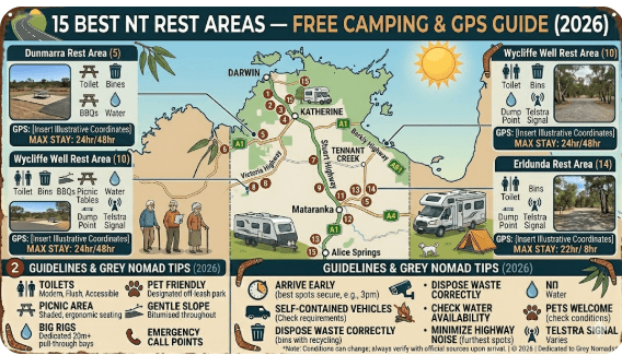
The 15 Best NT Rest Areas with GPS Coordinates
The following 15 rest areas are listed in order from south to north along the Stuart Highway, then branching east along the Barkly Highway and west along the Victoria Highway. Each entry includes GPS coordinates, highway location, facilities, and practical notes for caravans and senior travellers.
1 Attack Creek Rest Area — Stuart Highway
📍 GPS Coordinates — Attack Creek Rest Area
-18.6825, 133.5476
Stuart Highway, approximately 185 km north of Tennant Creek | NT
Attack Creek Rest Area sits alongside one of the most historically significant spots on the Stuart Highway — the place where explorer John McDouall Stuart was turned back by hostile conditions during his 1860 northward expedition. Today it serves as one of the most popular overnight rest stops on the northern section of the Stuart Highway for grey nomads heading toward Darwin.
The rest area has a large sealed parking area with room for multiple road trains and caravans simultaneously. Toilet facilities are provided. There is a historic marker explaining Stuart’s expedition, making it a worthwhile stop even if you’re not staying overnight. By late afternoon in the dry season, this site typically fills steadily — arriving before 3 pm is wise in peak season (May–August).
- Facilities: Toilets, picnic tables, shaded seating, historic marker
- Surface: Sealed entry, large sealed and gravel parking area
- Suitable for: All vehicle types including large caravans and motorhomes
- Stay limit: 18–24 hours (check posted signage)
- Nearest fuel north: Daly Waters (~130 km north)
- Nearest fuel south: Tennant Creek (~185 km south)
Full guide: Attack Creek Rest Area — Stuart Highway NT Outback Stop
2 Bonney Well Rest Stop — Stuart Highway
📍 GPS Coordinates — Bonney Well Rest Stop
-20.7461, 134.0892
Stuart Highway, approximately 100 km north of Tennant Creek | NT
Bonney Well is a quiet, uncrowded rest stop situated roughly halfway between Tennant Creek and the Barkly Highway junction. It is a useful intermediate stop for travellers who have misjudged distances or who simply need a fatigue break. The stop is basic but functional and is typically far less crowded than Attack Creek to the north.
- Facilities: Toilets, picnic tables
- Surface: Gravel parking area off sealed highway
- Suitable for: Caravans and motorhomes — manoeuvring space is adequate
- Stay limit: 18–24 hours
- Nearest fuel north: Tennant Creek (~100 km)
- Nearest fuel south: Barrow Creek (~100 km approximate)
Full guide: Bonney Well Rest Stop — Northern Territory Caravan Stop
3 Newcastle Waters Rest Area — Stuart Highway
📍 GPS Coordinates — Newcastle Waters Rest Area
-17.3817, 133.4047
Stuart Highway turnoff, approximately 90 km north of Elliott | NT
Newcastle Waters is a small historic droving town located just off the Stuart Highway, and its associated rest area is one of the most interesting on the entire NT highway network. The town itself is an open-air museum of droving history, with original buildings from the cattle driving era still standing. It is well worth a 30-minute wander.
The rest area has ample space for caravans and is popular with grey nomads who combine an overnight stop with a walk through the historic townsite. First-hand observation: the evening light on the old corrugated iron buildings here is genuinely atmospheric — one of those NT stops that stays in the memory long after the trip ends.
- Facilities: Toilets, picnic tables, historic walking trail
- Surface: Sealed and gravel, manageable for all rigs
- Suitable for: All vehicle types
- Stay limit: 18–24 hours
- Nearest fuel: Elliott (~90 km south), Daly Waters (~80 km north approximate)
Full guide: Newcastle Waters Rest Area — NT Free Camping Stop
4 King Rest Area — Stuart Highway
📍 GPS Coordinates — King Rest Area
-17.1543, 133.3687
Stuart Highway, between Elliott and Daly Waters | NT
King Rest Area is a mid-point stop on the often lengthy section of the Stuart Highway between Elliott and Daly Waters. For travellers who departed Alice Springs or Tennant Creek early in the morning, this can be a well-timed afternoon rest before pushing on to Daly Waters for the famous pub stop. The area is open, flat, and suitable for all vehicle configurations.
- Facilities: Toilets, picnic tables, shade structures
- Surface: Sealed entry, gravel parking area
- Suitable for: All vehicle types including road trains using adjacent areas
- Stay limit: 18–24 hours
- Nearest fuel north: Daly Waters (~60 km approximate)
- Nearest fuel south: Elliott (~70 km approximate)
Full guide: King Rest Area — NT Outback Truck and Caravan Stop
5 Limestone Creek Rest Area — Stuart Highway
📍 GPS Coordinates — Limestone Creek Rest Area
-16.4875, 133.1934
Stuart Highway, south of Daly Waters | NT
Limestone Creek is a pleasant rest area in a relatively more vegetated section of the Stuart Highway. The surrounding spinifex and scattered timber give it a different feel from the more open scrub further south. It’s a solid overnight stop for those who prefer a quieter setting away from the larger, busier rest areas.
- Facilities: Toilets, picnic tables, basic shade
- Surface: Sealed entry, gravel parking
- Suitable for: Caravans and motorhomes
- Stay limit: 18–24 hours
- Nearest fuel: Daly Waters (north), Elliott (south)
Full guide: Limestone Creek Rest Area — NT Free Overnight Stop
6 King West Rest Area — Stuart Highway
📍 GPS Coordinates — King West Rest Area
-17.2198, 133.3421
Stuart Highway, between Elliott and Daly Waters | NT
King West serves as a companion stop to the King Rest Area, positioned on the westbound or southbound side of the highway. It provides a useful pull-off for travellers heading south who need a break on this long, straight section. Facilities are basic but adequate. In good light, the surrounding landscape opens up into classic NT spinifex country — excellent for landscape photography.
- Facilities: Toilets, picnic tables
- Surface: Sealed entry and parking area
- Suitable for: All vehicle types
- Stay limit: 18–24 hours
- Nearest fuel: Elliott (south), Daly Waters (north)
Full guide: King West Rest Area — NT Highway Rest Stop
7 Noel Buntine Memorial Rest Area — Stuart Highway
📍 GPS Coordinates — Noel Buntine Memorial Rest Area
-15.5219, 133.1043
Stuart Highway, south of Mataranka | NT
The Noel Buntine Memorial Rest Area honours a long-serving NT roadside assistance volunteer and is a well-maintained facility. As the vegetation begins to transition toward the more tropical growth of the Katherine region, this rest area sits in a noticeably greener stretch of highway. It is a popular stop for travellers moving between Mataranka and Daly Waters.
- Facilities: Toilets, picnic tables, memorial interpretive display
- Surface: Sealed entry, good surface for caravans
- Suitable for: All vehicle types
- Stay limit: 18–24 hours
- Nearest fuel north: Mataranka (~60 km approximate)
- Nearest fuel south: Daly Waters (~100 km approximate)
Full guide: Noel Buntine Memorial Rest Area — NT Scenic Stop
8 Sullivan Campground Rest Area — Stuart Highway
📍 GPS Coordinates — Sullivan Campground Rest Area
-14.9843, 132.8765
Stuart Highway, between Mataranka and Katherine | NT
Sullivan Campground is one of the more established rest stops on the northern Stuart Highway and sits in one of the greenest sections of the corridor as you approach Katherine. The vegetation is noticeably more lush here — pandanus palms and tropical scrub begin to appear — and the atmosphere changes from the classic red-dirt outback to something more tropical.
- Facilities: Toilets, picnic tables, shaded areas
- Surface: Sealed entry, mixed surface parking
- Suitable for: Caravans, motorhomes, campervans
- Stay limit: 18–24 hours
- Nearest fuel: Mataranka (south), Katherine (north)
Full guide: Sullivan Campground Rest Area — NT Camping Stop
🛣️ Barkly Highway Rest Areas (East from Tennant Creek)
9 41 Mile Bore Rest Area — Barkly Highway
📍 GPS Coordinates — 41 Mile Bore Rest Area
-19.7234, 136.0478
Barkly Highway, approximately 66 km east of Tennant Creek | NT
The 41 Mile Bore Rest Area is the first substantial stop east of Tennant Creek on the Barkly Highway and serves as an important staging point for the long run across the Barkly Tablelands toward Queensland. The Barkly is one of Australia’s most demanding drives — hot, featureless, and with very limited services over hundreds of kilometres. This rest area is your last reliable stopping point before the landscape becomes truly remote.
- Facilities: Toilets, picnic tables, parking for heavy vehicles
- Surface: Sealed entry, large gravel parking area
- Suitable for: All vehicle types including road trains
- Stay limit: 18–24 hours
- Nearest fuel west: Tennant Creek (~66 km)
- Nearest fuel east: Barkly Homestead (~200 km east)
Full guide: 41 Mile Bore Rest Area — Barkly Highway NT Roadside Stop
10 Avon Downs Rest Area — Barkly Highway
📍 GPS Coordinates — Avon Downs Rest Area
-19.9854, 137.4523
Barkly Highway, Avon Downs area, Barkly Tablelands | NT
Avon Downs is a welcome pause in the middle of the Barkly Tablelands — one of Australia’s most exposed and featureless stretches of highway. The landscape here is vast open grassland, the sky seems enormous, and the silence at night is profound. For travellers who have never experienced true outback remoteness, this stop is genuinely memorable.
The Barkly Tablelands are one of the most important cattle grazing regions in Australia, and you’ll often see large cattle road trains using these rest areas. Be aware of very large vehicles at all times when manoeuvring.
- Facilities: Toilets, picnic tables, large truck parking area
- Surface: Sealed entry, gravel parking
- Suitable for: All vehicle types
- Stay limit: 18–24 hours
- Nearest fuel: Barkly Homestead (nearest to west), Camooweal QLD (east)
Full guide: Avon Downs Rest Area — Barkly Tablelands NT Stop
11 Frewena Rest Stop — Barkly Highway
📍 GPS Coordinates — Frewena Rest Stop
-19.4267, 135.9834
Barkly Highway, Frewena area | NT
Frewena is a small locality name rather than a township — do not expect services here. The rest stop at Frewena provides basic facilities for fatigue management on the Barkly Highway and serves both eastbound and westbound travellers. It sits in classic Barkly Tablelands country — wide, flat, and remarkably quiet.
- Facilities: Toilets, picnic tables
- Surface: Gravel parking off sealed highway
- Suitable for: Caravans and motorhomes
- Stay limit: 18–24 hours
- Nearest fuel: Tennant Creek (west), Barkly Homestead (east)
Full guide: Frewena Rest Stop — NT Stuart Highway Break Stop
12 Wonarah Bore Rest Area — Barkly Highway
📍 GPS Coordinates — Wonarah Bore Rest Area
-19.6543, 136.8921
Barkly Highway, Wonarah area | NT
Wonarah Bore is one of the more remote rest stops on the Barkly Highway and is notable for being a genuinely isolated stop with little to no traffic on a quiet night. The bore name refers to historical artesian bore activity in the region, part of the Great Artesian Basin’s western edge. This is a great spot for stargazing — light pollution here is essentially zero.
- Facilities: Toilets, picnic tables
- Surface: Gravel area, suitable for caravans and motorhomes
- Stay limit: 18–24 hours
- Nearest fuel: Barkly Homestead and Tennant Creek (both considerable distances)
Full guide: Wonarah Bore Rest Area — NT Outback Free Camp
13 Soudan Bore Rest Area — Barkly Highway
📍 GPS Coordinates — Soudan Bore Rest Area
-20.1087, 137.9234
Barkly Highway, approaching Queensland border | NT
Soudan Bore is one of the last NT rest areas before the Queensland border at Camooweal, and serves as a logical final outback stop before re-entering a more serviced environment. Like its nearby bore-named cousins, it sits in flat, open Barkly country with excellent night sky visibility and very quiet surroundings after dark.
- Facilities: Toilets, picnic tables, large vehicle parking
- Surface: Sealed entry, gravel parking
- Suitable for: All vehicle types
- Stay limit: 18–24 hours
- Nearest fuel east: Camooweal QLD (~80 km approximate)
- Nearest fuel west: Barkly Homestead
Full guide: Soudan Bore Rest Area — NT Roadside Camping Stop
🛣️ Victoria Highway Rest Areas (West from Katherine)
14 East Baines Rest Area — Victoria Highway
📍 GPS Coordinates — East Baines Rest Area
-15.6342, 129.8712
Victoria Highway, east of Timber Creek | NT
The East Baines Rest Area sits in one of the NT’s most scenic highway corridors. The Victoria Highway through this section passes through a dramatically varied landscape of red rock escarpments, tropical woodlands, and broad river floodplains. The East Baines stop is near the Baines River country and is popular with travellers heading toward the Keep River National Park or Kununurra in WA.
- Facilities: Toilets, picnic tables, shaded areas
- Surface: Sealed entry, mixed surface parking
- Suitable for: Caravans and motorhomes — check turning space on arrival
- Stay limit: 18–24 hours
- Nearest fuel: Timber Creek (west), Katherine (east)
- Crocodile warning: Any waterway in this region may contain crocodiles — observe all warning signs
Full guide: East Baines Rest Area — Victoria Highway NT Free Camp
15 Beef Road Monument Rest Area — Victoria Highway
📍 GPS Coordinates — Beef Road Monument Rest Area
-15.7689, 130.2341
Victoria Highway, Timber Creek region | NT
The Beef Road Monument Rest Area commemorates the construction of the Victoria Highway beef road network that opened up the remote northwest NT to cattle transport. The monument and interpretive display give this stop genuine historical interest, making it more than just a functional rest stop. The surrounding landscape in the Timber Creek region is spectacular — rugged red escarpments, vast flood plains, and tropical woodland.
This is a popular stop for tourists visiting the nearby Keep River National Park (just across the WA border) and for travellers making the Katherine-to-Kununurra run. At peak season it can attract a steady flow of campervans and caravans from late afternoon onward.
- Facilities: Toilets, picnic tables, interpretive monument, parking
- Surface: Sealed entry, gravel and compacted earth parking
- Suitable for: All vehicle types
- Stay limit: 18–24 hours
- Nearest fuel: Timber Creek (nearby — confirm operating hours before relying on it), Katherine (east)
Full guide: Beef Road Monument Rest Area — NT Tourist Stop
Fuel Stops Along NT Highways — Distance Guide
Fuel planning is not optional in the NT — it is a survival consideration. The distances between reliable fuel stops on all three major NT highway corridors are far greater than anywhere in coastal Australia. The following tables give you the information you need to plan your fuel stops safely.
Stuart Highway — Key Fuel Stop Distances (South to North)
| Town / Fuel Stop | Distance to Next Stop (North) | Notes |
|---|---|---|
| Kulgera (SA/NT border) | ~278 km to Alice Springs | Last fuel in SA heading north; limited services |
| Alice Springs | ~188 km to Ti Tree | Full services, supermarkets, major centre |
| Ti Tree | ~192 km to Tennant Creek | Small roadhouse, fuel, basic supplies |
| Tennant Creek | ~260 km to Daly Waters via Elliott | Full services, supermarket, caravan park |
| Elliott | ~110 km to Daly Waters | Roadhouse, basic fuel and supplies |
| Daly Waters | ~93 km to Larrimah | Iconic pub and roadhouse; fuel and meals |
| Larrimah | ~70 km to Mataranka | Small roadhouse; confirm hours before visiting |
| Mataranka | ~105 km to Katherine | Fuel, hot springs nearby, caravan park |
| Katherine | ~317 km to Pine Creek / Darwin areas | Full services, major regional centre |
| Pine Creek | ~230 km to Darwin | Small town, basic fuel and services |
| Darwin | — | Northern terminus; full services |
Barkly Highway — Key Fuel Stop Distances (West to East)
| Town / Fuel Stop | Distance to Next Stop (East) | Notes |
|---|---|---|
| Tennant Creek | ~265 km to Barkly Homestead | Last full services heading east; fill up here |
| Barkly Homestead Roadhouse | ~190 km to Camooweal QLD | Remote roadhouse; meals, fuel, basic accommodation |
| Camooweal (QLD border) | ~188 km to Mount Isa QLD | Small town, fuel, first services crossing into QLD |
Victoria Highway — Key Fuel Stop Distances (East to West)
| Town / Fuel Stop | Distance to Next Stop (West) | Notes |
|---|---|---|
| Katherine | ~190 km to Timber Creek | Full services; last major centre heading west |
| Timber Creek | ~220 km to Kununurra WA | Small town; fuel and basic services — confirm hours |
| Kununurra (WA) | — | Full services; Western Australia begins here |
Heat, Remoteness & Senior Safety
The Northern Territory presents genuine physical challenges for older travellers that simply do not exist in coastal or temperate regions of Australia. Understanding and preparing for these challenges is not alarmist — it is essential for a safe and enjoyable trip.
Temperature Extremes
Even in the peak dry season travel months of May–August, temperatures in the NT can reach 35–38°C in the afternoon. In the shoulder months of April and September, temperatures regularly exceed 40°C. Humidity in the pre-wet season (October–November) adds significant heat stress on top of high temperatures.
Water Carrying Recommendations
For NT outback travel in a caravan or motorhome:
- Carry a minimum of 20 litres of drinking water per person in addition to your vehicle’s tank
- Store water in sealed, food-grade containers out of direct sunlight
- Do not rely on bore water at rest areas for drinking unless it is clearly signed as potable
- Replenish your water supply at every opportunity — do not wait until you are low
Remoteness and Breakdown Risk
On the Barkly Highway in particular, vehicle breakdowns can leave you stranded for many hours before assistance arrives. Have your vehicle fully serviced before any NT trip. Carry a comprehensive toolkit, at least two full-size spare tyres, and the means to contact emergency services — either a satellite communicator (PLB or EPIRB) or a satellite phone, as mobile coverage is non-existent across most of the Barkly.
Wildlife — What to Watch For
The Northern Territory is home to extraordinary wildlife, and outback rest areas are genuinely excellent locations for observing it — particularly at dawn and dusk. However, wildlife in the NT also presents road safety risks that must be taken seriously.
Nocturnal Road Hazards
- Cattle and horses — open range country; animals can be on the road at any time, particularly at night. A collision with a cow or horse at highway speed is potentially fatal. Avoid driving after dark wherever possible in the NT
- Kangaroos and wallabies — most active at dawn and dusk; can appear suddenly from roadside scrub
- Wombats — less common but present in southern NT areas near the SA border
- Feral camels — particularly in the central NT; very large and highly dangerous in a collision
Wildlife to Enjoy at Rest Areas
- Birds: Major Mitchell cockatoos, galahs, budgerigars (wild flocks), wedge-tailed eagles, kites, finches in the tropical north
- Reptiles: Blue-tongue lizards, perenties (Australia’s largest monitor lizard), various skinks, and in tropical areas — frilled-neck lizards
- Crocodiles: Any waterway north of Katherine and along the Victoria Highway may harbour both freshwater and saltwater crocodiles. Keep well clear of all water edges and observe all signage
- Snakes: Multiple highly venomous species are present throughout the NT. Watch where you step, particularly around picnic table areas at rest stops where rocks and logs are common
Best Time to Visit — Month-by-Month Breakdown
| Month | Season | Conditions | Recommended? |
|---|---|---|---|
| January–March | Wet Season (Peak) | Heavy rain, flooding, extreme humidity, road closures likely on Victoria Hwy and parts of Stuart Hwy | ❌ Not recommended for most travellers |
| April | Wet Season (End) | Rain easing, but flooding risk remains — especially Victoria Highway. Stuart Hwy usually passable | ⚠️ Check road conditions daily |
| May–June | Early Dry Season | Excellent — warm days (25–32°C), cool nights, green vegetation from wet season, good wildlife activity | ✅ Highly recommended — peak season begins |
| July–August | Mid Dry Season (Peak) | Perfect outback weather — warm sunny days, cool nights, all roads open. Very busy — rest areas fill early | ✅ Best months — arrive at rest areas by 3 pm |
| September | Late Dry Season | Heating up — temperatures rising toward 38–42°C, less crowded than July/August, roads still good | ✅ Good but prepare for heat |
| October | Build-up (Pre-Wet) | Hot and increasingly humid — temperatures can reach 40°C+, thunderstorms begin, mosquitoes increase | ⚠️ Manageable but demanding for seniors |
| November–December | Early Wet Season | Storms, high humidity, some flooding beginning. Roads may close with little warning | ❌ Not recommended without local knowledge |
Dump Points Near NT Rest Areas
NT rest areas do not have dump point facilities. Dump points are available at the major serviced centres along the highway corridors. The following locations have publicly accessible dump points as of 2026 — always verify current availability using CamperMate or WikiCamps before relying on them.
| Location | Highway | Dump Point Notes |
|---|---|---|
| Alice Springs | Stuart Hwy | Multiple dump points — caravan parks and council facilities |
| Tennant Creek | Stuart Hwy | Available at caravan park — confirm access for non-guests |
| Elliott | Stuart Hwy | Basic facilities — check WikiCamps for current status |
| Katherine | Stuart / Victoria Hwy | Multiple options including council dump point |
| Mataranka | Stuart Hwy | Available at the Territory Manor — confirm with facility |
| Daly Waters | Stuart Hwy | Check at the roadhouse — limited facilities |
| Darwin | Stuart Hwy | Multiple options — caravan parks and council facilities |
| Camooweal (QLD) | Barkly Hwy (QLD side) | Council dump point — check current status on arrival |
Free Water Sources Along NT Highways
Free potable water is not available at NT highway rest areas as a general rule. Do not assume any bore or tank at a rest area provides drinking water unless it is clearly signed as such by the NT Government. Most NT rest area water (where present) is for vehicle cooling or hand washing only.
Reliable potable water refill points along the highway corridors include:
- Alice Springs: Town water supply — tap water is safe to drink
- Tennant Creek: Town water available at caravan parks and public facilities
- Katherine: Town water supply — tap water is safe
- Darwin: Town water — safe to drink
- Roadhouses (Ti Tree, Elliott, Daly Waters, Mataranka, etc.): Water may be available for purchase or as a courtesy — always ask
Phone Signal & Emergency Communications in the NT
Mobile phone coverage in the NT follows the highway corridors for short distances either side of the road but extends no further into the outback. The following is a realistic assessment of coverage by area:
| Location / Highway Section | Mobile Coverage | Recommended Backup |
|---|---|---|
| Alice Springs town | Good — Telstra and Optus | Standard mobile adequate |
| Stuart Hwy — Alice Springs to Tennant Creek | Patchy — Telstra only in spots; large gaps | PLB or satellite communicator |
| Stuart Hwy — Tennant Creek to Katherine | Very limited — Telstra spots near towns only | Satellite communicator essential |
| Barkly Highway — entire length | Near zero — Barkly Homestead only reliable spot | Satellite communicator or satellite phone — mandatory |
| Victoria Highway — Katherine to WA border | Very limited — Timber Creek only | Satellite communicator essential |
| Darwin city and environs | Good — multiple carriers | Standard mobile adequate |
WiFi availability at NT rest areas: there is no WiFi at any NT highway rest area. WiFi may be available at roadhouses (sometimes for purchase), and in Darwin, Alice Springs, Katherine, and Tennant Creek at libraries, some roadhouses, and caravan parks.
Campfires, Cooking & Restrictions
Campfires are not permitted at NT highway rest areas unless a designated fire facility is specifically provided. Most rest areas do not have fire rings or BBQ facilities. Penalties for lighting unauthorised fires apply under NT law, and the fire risk in the NT during the dry season can be extreme.
- Gas cookers and self-contained cooking equipment are the recommended standard for NT rest area cooking
- Some rest areas have electric or gas BBQ facilities — these are noted in individual site descriptions where applicable
- During extreme fire danger periods, total fire bans may apply — check with NT Fire and Rescue before lighting any cooking fire
- Food and supplies: stock up at major centres (Alice Springs, Tennant Creek, Katherine, Darwin). Remote roadhouses carry only basic supplies at significantly higher prices than supermarkets
Pets at NT Rest Areas
Pets are generally permitted at NT highway rest areas, provided they are kept under effective control at all times. However, there are important considerations specific to the NT that go beyond the standard “keep your dog on a lead” advice:
- Snakes: The NT has numerous highly venomous snake species. Dogs and cats frequently encounter snakes at rest stops — particularly around grass edges, rocks, and scrub. Keep pets close and on lead at all times
- Heat: Do not leave pets in a vehicle in NT temperatures, even with windows open. Temperatures inside a vehicle can reach lethal levels within minutes. If your van does not have reliable air conditioning, carry your pet with you or ensure they have shade, ventilation, and water at all times
- Crocodiles (northern NT): Never allow a dog or cat near any waterway or waterhole in the tropical NT. Crocodiles will take pets that approach the water’s edge
- National Parks: Pets are not permitted within NT National Parks boundaries. If you are planning side trips to Nitmiluk, Kakadu, or Litchfield National Parks, your pet must remain in the vehicle or at a pet-friendly facility outside the park
Accessibility for Seniors with Mobility Limitations
NT rest areas have been progressively upgraded in recent years, and most of the 15 listed in this guide have accessible toilet facilities meeting modern Australian standards. However, the quality of accessible facilities varies significantly between sites.
- Toilet accessibility: Most larger NT rest areas on the Stuart Highway have accessible toilet cubicles. Remote Barkly Highway stops may have more basic facilities — always check recent traveller reviews on CamperMate or WikiCamps before a long run
- Ground surface: Many rest area parking and walking areas have gravel or compacted earth surfaces that can be challenging for walkers, mobility aids, or wheelchairs. A walking frame or rollator may need extra support on these surfaces
- Shade: Shade at NT rest areas varies considerably. Some have substantial shade structures; others are exposed. In peak heat conditions, prioritise stops with shade facilities for resting during midday hours
- Parking space: All major NT rest areas have generous parking areas suitable for large rigs with reasonable flat access to toilet facilities. If you need to park close to toilet facilities, arriving earlier in the day gives you the best choice of position
🗺️ Vanlife Savings Spots — GPS Coordinates and Postcodes
Every NT rest area listed in this guide represents a genuine free overnight stop. The following consolidated GPS reference is designed to be saved or screenshotted for use with your navigation device or phone map app. Cross-reference with the interactive map below for the full picture.
| # | Rest Area | Highway | GPS Coordinates | Postcode Region | Full Guide |
|---|---|---|---|---|---|
| 1 | Attack Creek | Stuart Hwy | -18.6825, 133.5476 | NT 0862 | Guide |
| 2 | Bonney Well | Stuart Hwy | -20.7461, 134.0892 | NT 0861 | Guide |
| 3 | Newcastle Waters | Stuart Hwy | -17.3817, 133.4047 | NT 0862 | Guide |
| 4 | King Rest Area | Stuart Hwy | -17.1543, 133.3687 | NT 0862 | Guide |
| 5 | Limestone Creek | Stuart Hwy | -16.4875, 133.1934 | NT 0852 | Guide |
| 6 | King West | Stuart Hwy | -17.2198, 133.3421 | NT 0862 | Guide |
| 7 | Noel Buntine Memorial | Stuart Hwy | -15.5219, 133.1043 | NT 0852 | Guide |
| 8 | Sullivan Campground | Stuart Hwy | -14.9843, 132.8765 | NT 0852 | Guide |
| 9 | 41 Mile Bore | Barkly Hwy | -19.7234, 136.0478 | NT 0861 | Guide |
| 10 | Avon Downs | Barkly Hwy | -19.9854, 137.4523 | NT 0861 | Guide |
| 11 | Frewena | Barkly Hwy | -19.4267, 135.9834 | NT 0861 | Guide |
| 12 | Wonarah Bore | Barkly Hwy | -19.6543, 136.8921 | NT 0861 | Guide |
| 13 | Soudan Bore | Barkly Hwy | -20.1087, 137.9234 | NT 0861 | Guide |
| 14 | East Baines | Victoria Hwy | -15.6342, 129.8712 | NT 0852 | Guide |
| 15 | Beef Road Monument | Victoria Hwy | -15.7689, 130.2341 | NT 0852 | Guide |
📍 Interactive map — find free camps, rest areas and overnight stops across the NT. Enable location for best results.
COPY PROMPT ➔ ASK AI ➔ SAVE TO FORM ➔ ADD SPOT PIN ➔ GET DIRECTIONS
Full Facilities Comparison Table — All 15 NT Rest Areas
| Rest Area | Highway | Toilets | Tables | Shade | HV OK | History/Interest | Stay Limit |
|---|---|---|---|---|---|---|---|
| Attack Creek | Stuart | ✅ | ✅ | ✅ | ✅ | Historic marker | 18–24 hr |
| Bonney Well | Stuart | ✅ | ✅ | Partial | ✅ | — | 18–24 hr |
| Newcastle Waters | Stuart | ✅ | ✅ | ✅ | ✅ | Historic droving town | 18–24 hr |
| King Rest Area | Stuart | ✅ | ✅ | ✅ | ✅ | — | 18–24 hr |
| Limestone Creek | Stuart | ✅ | ✅ | Partial | ✅ | — | 18–24 hr |
| King West | Stuart | ✅ | ✅ | Partial | ✅ | — | 18–24 hr |
| Noel Buntine Mem. | Stuart | ✅ | ✅ | ✅ | ✅ | Memorial display | 18–24 hr |
| Sullivan Campground | Stuart | ✅ | ✅ | ✅ | ✅ | — | 18–24 hr |
| 41 Mile Bore | Barkly | ✅ | ✅ | Partial | ✅ | — | 18–24 hr |
| Avon Downs | Barkly | ✅ | ✅ | Partial | ✅ | — | 18–24 hr |
| Frewena | Barkly | ✅ | ✅ | Limited | ✅ | — | 18–24 hr |
| Wonarah Bore | Barkly | ✅ | ✅ | Limited | ✅ | Stargazing | 18–24 hr |
| Soudan Bore | Barkly | ✅ | ✅ | Partial | ✅ | — | 18–24 hr |
| East Baines | Victoria | ✅ | ✅ | ✅ | ✅ | Scenic gorge country | 18–24 hr |
| Beef Road Monument | Victoria | ✅ | ✅ | ✅ | ✅ | Historical monument | 18–24 hr |
Senior Safety Checklist — NT Outback Travel 2026
- Full fuel tank — confirmed distance to next fuel stop
- Minimum 20 litres extra drinking water per person carried
- PLB or satellite communicator charged and accessible
- Next rest area GPS coordinates loaded into navigation system
- Informed a responsible person of today’s planned route and expected arrival time
- NT Road Report checked — roadreport.nt.gov.au
- Weather forecast checked — bom.gov.au
- Vehicle tyres checked — pressure correct for load and conditions
- Two full-size spare tyres confirmed on board
- Planned to be parked at rest stop before sunset (no night driving)
- Food and medication supply sufficient for planned travel day plus 24 hours emergency
- Generator fuel (if applicable) sufficient for planned stop
- All medicines, sunscreen, and insect repellent packed and accessible
- Pet secured safely and water supply confirmed
- Caravan/trailer coupling, lights, and brakes checked before departure
Emergency Scenarios — What to Do
Vehicle Breakdown — Remote NT Location
- Pull completely off the road surface — use the full gravel shoulder, not just the road edge
- Place hazard lights on immediately
- Set up warning triangles or flares at least 100 metres behind the vehicle in each direction
- Stay with your vehicle — a stationary vehicle is far easier to locate than a person on foot in the outback
- Activate PLB if you cannot get mobile signal and need emergency assistance
- Provide shade for all occupants using your caravan awning or available materials — heat exposure is the most immediate risk
- Ration water until rescue is confirmed — do not consume your emergency water supply prematurely
- If you have satellite messaging capability, send your GPS coordinates and situation to your emergency contact
Medical Emergency at a Remote Rest Area
- Call 000 — if you have mobile signal, this will connect to emergency services even on roaming networks
- If no mobile signal, activate your PLB immediately — this alerts search and rescue which will coordinate medical assistance
- Keep the patient comfortable, cool, and hydrated if they are conscious
- Do not move a patient with suspected spinal injury
- Flag down passing traffic to assist or relay a message — road trains and other travellers frequently carry UHF radios on Channel 40
- The Royal Flying Doctor Service (RFDS) operates throughout the NT — in a confirmed medical emergency requiring evacuation, they can reach most NT locations
Packing List for NT Highway Travel
Safety and Emergency Essentials
- PLB (Personal Locator Beacon) — registered with AMSA
- Satellite communicator (Garmin inReach or similar) — strongly recommended for Barkly Highway
- UHF CB radio — Channel 40 for road communication
- First aid kit — comprehensive, including thermal blanket, triangular bandages, and snake bite bandages
- Two full-size spare tyres plus tyre repair kit
- Jumper cables or jump starter pack
- Tow rope or snatch strap
- Basic toolkit (screwdrivers, spanners, duct tape, zip ties)
- Fire extinguisher — vehicle-rated
Water and Food
- Minimum 20 litres extra drinking water per person in approved containers
- 3–5 days of non-perishable emergency food supply
- Water purification tablets or filter as backup
- Electrolyte sachets for heat management
Comfort and Practical Items
- Insect repellent — DEET-based for tropical NT areas
- High-SPF sunscreen
- Wide-brim hat and UV-protective clothing
- Quality torch and spare batteries
- Paper maps of NT highways — do not rely solely on GPS
- Cash — remote roadhouses do not always have reliable EFTPOS
- Fuel jerry cans (approved) — minimum 20 litres extra fuel for Barkly and Victoria Highway sections
Reviews — What Grey Nomads Say About NT Rest Areas
“We did the full Stuart Highway run from Adelaide to Darwin in June 2025 and used six rest areas from this guide. Attack Creek was a highlight — arrived at 4 pm and it was already filling up with a good community of travellers. The historic marker about Stuart’s expedition was genuinely interesting and we spent a good 20 minutes reading it before sunset. Facilities were clean and adequate. Would absolutely stop here again.”
“The Barkly Highway is something else — we’d done the Stuart many times but this was our first time across the Barkly. The 41 Mile Bore stop was exactly what it says — basic but functional. Saved us at least $45 compared to staying in Tennant Creek for another night. The silence on the Barkly is extraordinary — not a sound except for one distant road train at about 2 am. Wonarah Bore had the best stars I’ve seen in years. Take a satellite phone or at minimum a PLB — there is no signal out there whatsoever.”
“Newcastle Waters was a pleasant surprise — we hadn’t planned to stop but the sign caught our eye and we pulled in for what ended up being a two-hour wander through the old town. The rest area itself was well maintained and perfectly positioned for our timing heading toward Katherine. Highly recommend building this into your Stuart Highway itinerary rather than just blasting past.”
“East Baines on the Victoria Highway — spectacular country around this stop. The escarpments and tropical bush were like nothing we’d seen on the Stuart. One thing to note — the parking area had a few rough spots and we were glad we’d checked our caravan jockey wheel before pulling in on the uneven edge. Crocodile signs everywhere near the waterway — take them seriously. We saw a freshie near the bank at dusk.”
Frequently Asked Questions — NT Rest Areas 2026
Can you stay overnight at NT rest areas for free?
Yes — NT highway rest areas are free to use and overnight stays are generally permitted for up to 18–24 hours. They are designated fatigue management stops intended to keep drivers safe on long outback highway routes. Always check posted signage at each specific site for the applicable stay limit.
Are NT rest areas suitable for large caravans?
Most NT highway rest areas are suitable for large caravans, fifth-wheelers, and motorhomes. They are also designed to accommodate heavy vehicles including road trains. Parking areas are generally large and flat. The key issue is that in peak dry season (June–August), popular stops fill from mid-afternoon — arriving by 3 pm gives you the best choice of position.
Is there mobile phone coverage at NT rest areas?
Coverage is very limited to non-existent at most NT highway rest areas. Telstra provides the best coverage of any carrier in the NT, but even Telstra has extensive coverage gaps along the Stuart Highway and essentially no coverage along most of the Barkly Highway. A PLB or satellite communicator is strongly recommended for all NT outback travel.
Is the Barkly Highway sealed?
Yes — the Barkly Highway is sealed for its entire length between Tennant Creek and the Queensland border. However, sections may have surface damage, narrow lanes, and areas of flood repair. Fuel distances are extreme — the gap between Tennant Creek and Barkly Homestead is approximately 265 km with no services in between. Never attempt the Barkly without a full fuel tank and extra fuel.
Can the Victoria Highway flood and close?
Yes — the Victoria Highway is the NT’s most flood-prone major highway. It can close entirely during and after heavy wet season rain events. This highway should only be travelled between May and October by standard vehicles. Always check roadreport.nt.gov.au before departure. Never drive into floodwater on any NT road.
Are there dump points at NT rest areas?
No — NT highway rest areas do not have dump point facilities. Dump points are available at major centres including Alice Springs, Tennant Creek, Katherine, and Darwin. Use CamperMate or WikiCamps to locate the nearest dump point to your planned route.
Is it safe to drive the NT at night?
No — driving the NT outback highways after dark is strongly discouraged and considered dangerous by experienced outback travellers. Open range cattle, kangaroos, feral camels, and other wildlife on the road create extremely high collision risk after dark. Plan your driving to be parked at a rest area before sunset every day.
Are there crocodiles near NT rest areas?
In the northern NT — particularly north of Katherine on the Stuart Highway and throughout the Victoria Highway corridor — both saltwater and freshwater crocodiles are present in any permanent or semi-permanent waterway. Never approach any waterway, creek, or waterhole in this region. Do not allow pets or children near water edges. Observe all posted crocodile warning signs.
Quick-Reference Card — NT Rest Areas 2026
📋 NT Rest Area Quick Reference
| Total Rest Areas (this guide) | 15 — Stuart, Barkly & Victoria Highways |
| Cost | Free — all NT highway rest areas |
| Stay Limit | 18–24 hours — check posted signage each site |
| Best Travel Months | May, June, July, August (dry season) |
| Worst Travel Months | November–March (wet season — flooding risk) |
| Longest Fuel Gap | ~265 km — Tennant Creek to Barkly Homestead |
| Mobile Coverage | Very limited to zero — PLB essential |
| Road Conditions Check | roadreport.nt.gov.au |
| Weather Check | bom.gov.au |
| Emergency | 000 | PLB | RFDS 1800 625 800 |
| Campfires | Not permitted at rest areas unless facility provided |
| Dump Points | Not at rest areas — available at major towns |
| Potable Water | Not at rest areas — carry minimum 20L per person |
| Night Driving | Not recommended — wildlife collision risk |
| Pets | Permitted — on lead, keep away from water in north NT |
Free rest areas fill fast during peak dry season (June–August). If your planned stop is at capacity or you need a powered site with facilities, search available accommodation below for Alice Springs, Katherine, Darwin, or Tennant Creek.
Accommodation search powered by Expedia. Booking through this search supports this website at no extra cost to you. As an affiliate, I earn from qualifying purchases.
Travelling remote NT? Protect your vehicle at remote rest areas with StarterStopper.
Exclusive Offer: Get 5% OFF with promo code: RTV5
Visit StarterStopper.com — Vehicle Security for Remote Travellers
As an affiliate, I earn from qualifying purchases at no extra cost to you.
RV LIFE Trip Wizard
Note for US visitors: RV LIFE Trip Wizard is a USA-based RV trip planning tool and is designed for North American RV travellers. If you are visiting this site from the United States and planning an RV trip, this tool is an excellent route planning resource for US highways and campgrounds.

As an affiliate, I earn from qualifying purchases at no extra cost to you.
Nearby Northern Territory Rest Areas — Individual Guides
- Attack Creek Rest Area — Stuart Highway NT Outback Stop
- 41 Mile Bore Rest Area — Barkly Highway NT Roadside Stop
- Bonney Well Rest Stop — Northern Territory Caravan Stop
- Newcastle Waters Rest Area — NT Free Camping Stop
- King Rest Area — NT Outback Truck and Caravan Stop
- Limestone Creek Rest Area — NT Free Overnight Stop
- King West Rest Area — NT Highway Rest Stop
- Noel Buntine Memorial Rest Area — NT Scenic Stop
- Sullivan Campground Rest Area — NT Camping Stop
- East Baines Rest Area — Victoria Highway NT Free Camp
- Beef Road Monument Rest Area — NT Tourist Stop
- Avon Downs Rest Area — Barkly Tablelands NT Stop
- Frewena Rest Stop — NT Barkly Highway Break Stop
- Wonarah Bore Rest Area — NT Outback Free Camp
- Soudan Bore Rest Area — NT Roadside Camping Stop
© 2026 RetireToVanLife.com — All rights reserved. Written for Senior Grey Nomads. Safe travels. 🚐