King West Rest Area
Senior Grey Nomad Guide 2026 — GPS coordinates, road conditions, fuel stops, facilities, wildlife, heat safety, and everything you need for a comfortable overnight stop on the Stuart Highway, Northern Territory.
📅 Last reviewed: January 2026 | Stuart Highway, Northern Territory | Free overnight stop — remote outback highway setting
📋 Table of Contents
- Why Grey Nomads Stop at King West Rest Area
- Free Camping — Know the Rules for Seniors
- Quick Facts and Key Details 2026
- How to Get There + GPS Coordinates
- Road Conditions, Flooding and Sealed Highway Info
- Heat and Remoteness — Senior Safety
- Wildlife — Birds, Reptiles and What to Watch For
- What Other Websites Don’t Tell You
- Best Time to Visit — Month-by-Month Breakdown
- Free and Low-Cost Camping Alternatives Nearby
- Dump Points Near King West Rest Area
- Free Water Sources Near the Stuart Highway
- Fuel Stops Along the Stuart Highway
- Caravan Parks — Paid Alternatives
- Full Facilities Comparison Table
- Rates — All Options Near King West 2026
- Senior Safety Checklist — On and Off the Road
- What to Do Near King West — Senior Activity Guide
- Vanlife Savings Spots — GPS Coordinates and Postcodes
- Phone Signal and Emergency Communications
- Campfires, Cooking and Food Purchases Nearby
- Pets at King West Rest Area
- Accessibility for Seniors with Mobility Limitations
- Permits, Fees, Etiquette and Waste Management
- Emergency Scenarios — What to Do
- Packing List for This Section of the Stuart Highway
- 5 Rest Areas Near King West on the Stuart Highway
- Reviews — What Grey Nomads Say
- Frequently Asked Questions
- Quick-Reference Card
- Disclaimer
1. Why Grey Nomads Stop at King West Rest Area
The King West Rest Area sits alongside the Stuart Highway in the Northern Territory, positioned between Alice Springs and Tennant Creek — one of Australia’s most iconic and demanding long-distance drives. For senior grey nomads completing the centre crossing, this rest area provides a critical, no-cost overnight refuge on a stretch of highway where services can be separated by well over 100 kilometres.
The Stuart Highway is the backbone of the Red Centre. It connects Adelaide to Darwin across more than 3,000 kilometres of largely empty outback terrain. King West Rest Area is positioned in the vast pastoral country typical of central Australia — low scrub, red sandy soil, spinifex and a horizon that seems to go on forever. For those who have never driven this corridor before, the scale of it genuinely takes the breath away.
Grey nomads travelling south from Darwin or north from Alice Springs commonly use King West as a mid-point rest stop, a lunch break, or a full overnight stop. It breaks the fatigue that builds on this long, hypnotic highway where the road rarely bends and driver alertness can drop surprisingly fast — particularly in the heat of the afternoon.
First-hand observation: Arriving at King West late one April afternoon, we counted four vans already parked up and a couple of road-tripping families using the picnic facilities. By dusk, the rest area had filled further. The quiet that settles over this part of the NT after sunset is something most travellers don’t expect — a profound stillness broken only by the occasional road train thundering past.
2. Free Camping — Know the Rules for Seniors
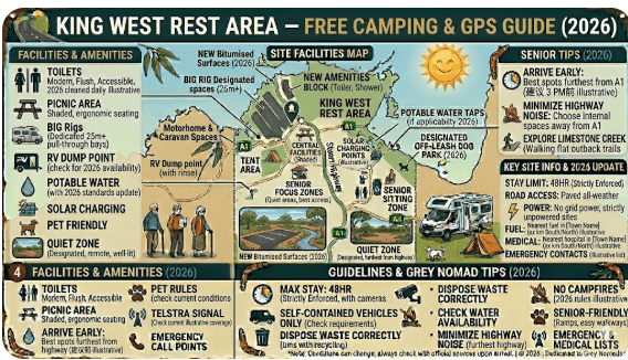
King West Rest Area is a designated NT Government rest area, positioned on the Stuart Highway specifically to reduce driver fatigue. Overnight stays are generally permitted at NT rest areas under the government’s fatigue management policy, though no formal booking is required and there is no defined maximum stay posted on-site (unlike some NSW rest areas which enforce a 20-hour limit).
There are no fees to use King West Rest Area. No permit is required. You pull in, park safely, rest, and move on. This is a genuine free overnight stop — and one of the few reliable options on this particular section of the highway.
Free Camping vs Paid Sites — Vanlife Savings Tip
Stopping at King West instead of pushing on to a caravan park at Tennant Creek or Alice Springs can realistically save you between $30 and $60 per night depending on your rig and whether you need powered sites. For grey nomads on a self-sufficient setup — solar, water tanks, and a composting or cassette toilet — this is a zero-cost stop with everything you need for a comfortable night.
3. Quick Facts and Key Details 2026
| Detail | Information |
|---|---|
| 📍 Location | Stuart Highway, Northern Territory |
| 🗺️ Nearest Town (North) | Tennant Creek (~approx. 100–120 km north) |
| 🗺️ Nearest Town (South) | Alice Springs (~approx. 200–220 km south) |
| 📮 Postcode | NT 0870 (general outback NT region) |
| 🧭 GPS Coordinates | Approx. -20.35, 134.18 (see GPS section for detail) |
| 💵 Cost | Free |
| 🕐 Stay Limit | No formal posted limit — 1 night recommended |
| 🚛 Suitable For | Caravans, motorhomes, campervans, trucks, heavy vehicles |
| 🚿 Toilets | Pit or composting toilets (basic; no flush) |
| 🪑 Picnic Tables | Yes — basic shade shelters with tables |
| 💧 Water | No potable water on-site — carry your own |
| 🔌 Power | No powered sites |
| 🗑️ Bins | Bins may or may not be present — carry-in/carry-out policy applies |
| 📶 Phone Signal | Very limited — Telstra may provide marginal signal |
| 🐕 Pets | Permitted — on lead at all times |
| 🔥 Campfires | No campfires permitted at the rest area |
| 🌡️ Climate Zone | Semi-arid to arid — extreme heat in summer |
Northern Territory Rest Area Network
If you’re travelling through the Northern Territory, these rest areas form part of a reliable network of free and low-cost stops across major outback highways. From the Stuart Highway to the Barkly and Victoria Highway routes, these locations are popular with caravanners, road trippers, and long-haul drivers.
- Attack Creek Rest Area on the Stuart Highway
- 41 Mile Bore Rest Area along the Barkly Highway
- Bonney Well Rest Stop in the NT outback
- Newcastle Waters Rest Area free camping stop
- King Rest Area suitable for caravans and trucks
- Limestone Creek Rest Area overnight stop
- King West Rest Area highway break stop
- Noel Buntine Memorial Rest Area scenic stop
- Sullivan Campground Rest Area camping area
- East Baines Rest Area on the Victoria Highway
- Beef Road Monument Rest Area tourist stop
- Avon Downs Rest Area on the Barkly Tablelands
- Frewena Rest Stop on the Stuart Highway
- Wonarah Bore Rest Area free camp
- Soudan Bore Rest Area roadside camping
4. How to Get There + GPS Coordinates
📍 GPS Coordinates — King West Rest Area
Approx. -20.3500, 134.1800
Stuart Highway, Northern Territory
Coordinate source: Publicly available mapping data. Always confirm using your GPS device, WikiCamps, or Campermate prior to departure.
Coming From Alice Springs (Travelling North)
Head north on the Stuart Highway (A1) out of Alice Springs. The road is fully sealed, flat, and well-maintained for the entire journey. King West Rest Area will appear on your right-hand (east) side of the highway, marked with standard NT rest area signage. The access point is a sealed or compacted gravel pull-off — take it slowly if towing a large rig, as the angle of entry can catch you off guard if approaching at highway speeds.
Coming From Tennant Creek (Travelling South)
Head south from Tennant Creek on the Stuart Highway. The rest area will appear on your left-hand (east) side of the highway. Signage typically begins 1–2 kilometres ahead of the turn-off. Allow time to slow safely — road trains and heavy vehicles travel this stretch at speed, and sudden braking on a long straight road can create a hazard for following traffic.
Suitability for Caravans, Motorhomes and Big Rigs
The rest area is designed for all vehicle types including road trains. The turning and parking area is generous — large motorhomes, fifth-wheelers, and caravans towed by large 4WD vehicles have ample room to manoeuvre. The surface is compacted gravel or hard-packed dirt — not sealed — so those with low-clearance motorhomes should approach carefully and check for any soft patches after recent rain. Standard highway-capable vehicles have no issue accessing the site.
5. Road Conditions, Flooding and Sealed Highway Info
Is the Stuart Highway Sealed?
Yes. The Stuart Highway through this section is fully sealed bitumen — one of the most important roads in Australia. It is maintained by the NT Government and is generally in good condition, though stretches can develop surface cracking and edge breaks in the intense heat. Road trains travel this route around the clock, and their passage can cause minor road surface deformation in the warmer months.
Does the Road Flood?
The Stuart Highway can and does flood in the wet season (approximately November to March/April). Heavy monsoonal rainfall — even from storms hundreds of kilometres away — can cause water to flow across the highway at low-lying sections. In major flood events, the highway can be closed for days at a time, leaving travellers stranded between towns.
Wet Season Road Conditions at the Rest Area
The rest area itself may become partially unusable in very heavy rain — access from the highway is typically via a compacted surface that can become slippery when wet. Large motorhomes and caravans should exercise caution entering and exiting the site after rain. Allow the surface to dry before attempting to re-join the highway if conditions have deteriorated overnight.
Is Any Section Unsealed?
The Stuart Highway itself is fully sealed. The rest area access surface is typically compacted gravel or packed dirt — effectively unsealed. Side roads or station tracks in the region are unsealed and require 4WD in wet conditions. Unless you are venturing off the highway, a 2WD motorhome or caravan has no issues on this route.
6. Heat and Remoteness — Senior Safety
This is one of the most important sections of this guide for senior travellers. The stretch of Stuart Highway around King West Rest Area runs through one of the most extreme climates in Australia. Summer temperatures regularly exceed 40°C and can reach well into the mid-40s. The overnight temperature drop can be significant — below 15°C in winter — which creates its own challenges for older travellers.
Heat-Related Health Risks
- Dehydration — occurs faster than most people realise in low-humidity outback heat. Drink water constantly, even when not thirsty.
- Heat exhaustion — symptoms include heavy sweating, weakness, dizziness, nausea. Move immediately to shade or an air-conditioned space.
- Heat stroke — a medical emergency. Call 000 immediately if a person stops sweating, becomes confused, or loses consciousness.
- Sun exposure — UV is intense year-round in the NT. Wear SPF 50+ sunscreen, a wide-brimmed hat, and avoid direct sun between 10am and 3pm.
Remoteness Factor
King West Rest Area is genuinely remote. If you break down here or have a medical emergency, help may be 60–120 minutes or more away depending on traffic and emergency services availability. This is not a criticism — it is a reality of travelling this part of Australia, and part of the experience. But it demands preparation.
7. Wildlife — Birds, Reptiles and What to Watch For
Central Australia’s wildlife is one of the genuine highlights of travelling this highway. Even at a roadside rest area, the variety of species you may encounter can be remarkable — particularly in the cooler months when animal activity increases around dawn and dusk.
Birds
- Budgerigars — massive flocks can be seen in good seasons, swirling across the sky in formations that defy description
- Cockatiels — regularly seen along the highway corridor
- Wedge-tailed Eagles — Australia’s largest bird of prey; frequently seen feeding on roadkill along the highway. Give them space — they are slow to take off and can be struck by passing vehicles
- Galahs, corellas and sulphur-crested cockatoos — common at watering points near the highway
- Zebra finches — often found in large flocks near any water source
Reptiles
- Perentie — Australia’s largest goanna; may be seen near rest areas scavenging food scraps. Do not feed them.
- Central bearded dragon — commonly seen basking on warm road edges in the morning
- Sand goannas — active during the day in moderate temperatures
- Various species of skink and gecko — particularly active at night
Dangerous Wildlife
- Camels — feral camels are present in central Australia and can appear on or near the highway at night. A collision with a camel is as serious as hitting a large cow. Drive slowly after dark.
- Kangaroos and wallabies — highly active at dusk and dawn. This is the most dangerous time to drive on the Stuart Highway. If possible, park up before dusk and don’t move until after full sunrise.
- Wild cattle and horses (brumbies) — station stock occasionally wanders onto the highway. Especially a risk at night.
8. What Other Websites Don’t Tell You
Most camping app listings and government rest area databases are bare-bones — they tell you a rest area exists, give you rough coordinates, and list toilet availability. Here’s what the apps and government sites typically miss about King West Rest Area and this section of the Stuart Highway:
- Road train noise at night is significant. The Stuart Highway is a 24-hour freight corridor. Road trains travel at speed day and night. If you are a light sleeper, earplugs are essential. The ground vibration from a triple-trailer road train at 3am is unlike anything you experience at a caravan park.
- Flies are ferocious in warmer months. The outback blowfly in this region is relentless between roughly August and April. A good fly net for your hat and insect-proof mesh for your van’s windows and doors is not optional — it is essential.
- The silence after the trucks stop is extraordinary. In the quieter early hours, the stillness of the outback here is something city-raised travellers genuinely don’t expect. The night sky, away from any light pollution, is one of the best in Australia.
- Dust from road trains. When a road train passes at highway speed while you are outside the vehicle, the dust cloud can be significant. Keep food covered and stay back from the highway boundary.
- The toilet facilities are basic. Do not expect a flush toilet or running water. Pit or composting toilet facilities at remote NT rest areas are functional but basic. Carry your own hand sanitiser and toilet paper. These facilities are cleaned periodically but may not have been serviced recently on the day you arrive.
- There is no dump point at the rest area. If you have a cassette or black water tank, you will need to plan your dump point stop in Tennant Creek or Alice Springs. See the dump points section below.
9. Best Time to Visit — Month-by-Month Breakdown
| Month | Weather | Conditions | Verdict for Grey Nomads |
|---|---|---|---|
| January | Extreme heat, possible storms | Wet season risk; road may flood | ❌ Avoid if possible |
| February | Extreme heat, storms | Wet season; highest flood risk | ❌ Avoid |
| March | Hot, storms easing | Roads may still be affected | ⚠️ Caution advised |
| April | Warming, drying | Conditions improving rapidly | ✅ Good — shoulder season |
| May | Mild and dry | Excellent conditions | ✅✅ Ideal |
| June | Cool nights, warm days | Peak grey nomad season | ✅✅ Peak — busiest time |
| July | Cool nights (can be cold), warm days | Peak season continues | ✅✅ Peak — rest area fills by afternoon |
| August | Warming, comfortable | Still good — flies increasing | ✅✅ Excellent |
| September | Warm to hot | Good — heat building | ✅ Good |
| October | Hot | Heat increasing significantly | ⚠️ Caution — early starts essential |
| November | Very hot, storms beginning | Wet season approaching | ⚠️ Caution |
| December | Extreme heat, storms | Wet season; road risk | ❌ Avoid |
The peak grey nomad season at King West is May through August — the dry season when temperatures are most comfortable for travel. During this period, the rest area can fill by late afternoon, particularly on long weekends or in the peak school holiday period of July. Arriving by 3:00–4:00 pm gives the best chance of securing your preferred parking position.
10. Free and Low-Cost Camping Alternatives Nearby
- Attack Creek Historical Reserve — North of King West on the Stuart Highway; a heritage site with basic rest facilities and historical significance. Free.
- Tennant Creek Rest Areas — Several designated free rest stops on approaches to Tennant Creek township. Free.
- Banka Banka Station — A working cattle station north of Tennant Creek offering basic camping to travellers; small nightly donation or fee expected. Check current status before arrival.
- Wauchope Rest Area — Southbound on the Stuart Highway; basic facilities, free overnight.
- Devils Marbles Conservation Reserve (Karlu Karlu) — Approximately 110 km south of Tennant Creek; camping available in the reserve. A fee applies — pay via the NT Parks and Wildlife self-registration system on-site. This is one of the most spectacular overnight stops in central Australia.
11. Dump Points Near King West Rest Area
There is no dump point at King West Rest Area. The nearest dump points are located in the major towns on either end of this stretch of highway.
| Location | Direction | Approximate Distance | Notes |
|---|---|---|---|
| Tennant Creek | North | ~100–120 km | Dump point at Tennant Creek caravan parks and council facilities. Verify current location via Campermate. |
| Alice Springs | South | ~200–220 km | Multiple dump points in Alice Springs — caravan parks and town facilities. Check Campermate for current locations. |
| Wauchope (Roadhouse) | South | ~60–80 km approx. | Small roadhouse — dump point availability varies. Confirm before relying on this stop. |
Use Campermate.com.au or the WikiCamps app to locate and verify the nearest dump point to your current position in real time.
12. Free Water Sources Near the Stuart Highway
Where to Fill Your Water Tanks
- Alice Springs — Multiple locations including caravan parks, service stations and town facilities. Fill completely before heading north.
- Tennant Creek — Town water supply available at caravan parks. Fill completely before heading south.
- Roadhouses along the Stuart Highway — Some roadhouses sell water or allow tank fills for a small fee. Ask at the counter — do not assume water is available at any roadhouse without confirming first.
13. Fuel Stops Along the Stuart Highway
Fuel planning on the Stuart Highway is not optional — it is a matter of safety. Between Alice Springs and Tennant Creek, fuel stops are spaced well apart and prices reflect the remoteness and freight costs. Always fill up when you have the opportunity, even if your tank is still half full.
| Fuel Stop | Direction | Approx. Distance from King West | Notes |
|---|---|---|---|
| Tennant Creek (multiple service stations) | North | ~100–120 km | Best fuel prices in the region relative to remote stops. Unleaded, diesel, LPG available. |
| Wauchope Roadhouse | South | ~60–80 km approx. | Remote roadhouse — fuel available, premium prices. Hours may vary. |
| Barrow Creek Roadhouse | South | ~120–140 km approx. | Small roadhouse, historic pub attached. Fuel and very basic supplies. |
| Alice Springs (multiple service stations) | South | ~200–220 km | Best variety and competitive pricing. Stock up on supplies here. |
14. Caravan Parks — Paid Alternatives
If the rest area is full, facilities are insufficient for your needs, or you want a powered site, a hot shower, or camp kitchen facilities, the nearest caravan parks are in Tennant Creek to the north and Alice Springs to the south.
| Park | Location | Direction | Approx. Distance | Facilities |
|---|---|---|---|---|
| Tennant Creek (various parks) | Tennant Creek, NT | North | ~100–120 km | Powered sites, ablutions, dump point, camp kitchen |
| Alice Springs (various parks) | Alice Springs, NT | South | ~200–220 km | Full facilities, pool, WiFi, powered sites, ensuite options |
| Devils Marbles Conservation Reserve | Karlu Karlu, Stuart Hwy | South | ~110 km south of Tennant Creek | Basic camping — toilets, no power; fee payable on-site |
Free campsites and powered sites fill fast during the peak June–August grey nomad season. If your preferred site is already taken, search remaining accommodation options below to explore the region.
Accommodation and flight search powered by Expedia. Booking through this search supports this website at no extra cost to you. As an affiliate, I earn from qualifying purchases at no extra cost to you.
15. Full Facilities Comparison Table
| Facility | King West Rest Area | Tennant Creek Caravan Park | Devils Marbles Reserve |
|---|---|---|---|
| Cost per night | Free | ~$35–$55 powered | Fee applies (NT Parks) |
| Toilets | ✅ Pit/composting | ✅ Flush | ✅ Pit toilets |
| Showers | ❌ None | ✅ Hot showers | ❌ None |
| Power | ❌ None | ✅ 240V powered sites | ❌ None |
| Water (potable) | ❌ None | ✅ Yes | ❌ None |
| Dump point | ❌ None | ✅ Yes | ❌ None |
| WiFi | ❌ None | ✅ Some parks | ❌ None |
| Camp kitchen | ❌ None | ✅ Some parks | ❌ None |
| Picnic tables | ✅ Basic | ✅ Yes | ✅ Yes |
| Shade shelters | ✅ Some | ✅ Yes | ✅ Some |
| Laundry | ❌ None | ✅ Some parks | ❌ None |
| Pet friendly | ✅ On lead | ⚠️ Varies by park | ⚠️ Check NT Parks rules |
| Big rig suitable | ✅ Yes | ✅ Yes | ✅ Yes |
| Scenery | ⭐⭐⭐ Open outback | ⭐⭐ Town setting | ⭐⭐⭐⭐⭐ Spectacular |
16. Rates — All Options Near King West 2026
| Option | Cost (per night) | Notes |
|---|---|---|
| King West Rest Area | Free | No booking, no fees |
| Tennant Creek Caravan Park (unpowered) | ~$25–$35 | Facilities included |
| Tennant Creek Caravan Park (powered) | ~$40–$58 | 240V, facilities included |
| Devils Marbles Conservation Reserve | NT Parks fee (check current rates at nt.gov.au) | Self-registration on-site |
| Alice Springs Caravan Parks (unpowered) | ~$30–$40 | Facilities included |
| Alice Springs Caravan Parks (powered) | ~$45–$70 | Full facilities, some with pool |
| Station Stays (Banka Banka etc.) | ~$15–$30 donation/fee | Basic facilities; verify before arrival |
17. Senior Safety Checklist — On and Off the Road
- Fuel tank full — do not leave town at less than a full tank
- Water tanks filled — minimum 10 litres per person per day
- Food supplies adequate — no roadhouses guaranteed between stops
- GPS loaded with rest area coordinates for your intended stop
- NT road conditions checked — nt.gov.au road conditions
- BOM weather forecast checked — bom.gov.au NT
- Responsible person told of your travel plan and expected arrival time
- PLB or satellite communicator charged and accessible
- Medications checked — have you packed all daily medications?
- First aid kit stocked and accessible
- Sunscreen, wide-brimmed hat, fly net in reach
- Insect repellent packed
- Recovery gear and basic tools carried (tyre repair kit, jumper cables)
- Emergency phone numbers saved (NT Police: 131 444; Emergency: 000)
- Plan to stop before sunset — no night driving on this highway
- Tyre pressures checked before departure
- Jacks and wheel brace accessible (not buried under gear)
- Dump point stop planned for next major town
- Grey water storage confirmed — no dumping on the ground
18. What to Do Near King West — Senior Activity Guide
King West Rest Area itself is a functional stop rather than a tourist destination. However, the surrounding region is rich in natural and cultural significance, and the rest area serves as a convenient base for day trips to several extraordinary attractions.
Karlu Karlu / Devils Marbles Conservation Reserve
Approximately 110 km south of Tennant Creek and within reasonable driving distance of King West, Karlu Karlu is one of central Australia’s most iconic landscapes. The massive rounded granite boulders — some balanced seemingly impossibly on one another — are sacred to the Warumungu, Kaytetye, Alyawarr, and Anmatyerr Aboriginal peoples. A short loop walk takes visitors around the main boulder field. This is accessible for most seniors and is particularly spectacular at sunrise and sunset when the rocks glow deep red.
🪨 Karlu Karlu / Devils Marbles
Entry fee: NT Parks fee applies — pay via self-registration on-site. Current fee information at nt.gov.au/leisure/parks-reserves.
Facilities: Toilets, picnic tables, camping area (overnight fee payable).
Accessibility: The main viewing area and some paths are suitable for seniors with mobility limitations. The loop trail is mostly flat but on uneven rock surfaces in sections.
Best time: Sunrise and sunset for photography and cooler temperatures.
Tennant Creek (to the north)
- Tennant Creek Battery Museum — Free or low-cost admission; fascinating history of the NT gold rush era
- Nyinkka Nyunyu Art and Culture Centre — Aboriginal cultural centre with gallery and guided tours
- Tennant Creek Telegraph Station — Historic site from the Overland Telegraph Line era; walking distance from town
- Supermarkets and services — Tennant Creek has a full supermarket, pharmacy, medical services and fuel — stock up here
Stargazing
One of the absolute highlights of staying at a remote rest area in central NT is the night sky. Free from light pollution, the Milky Way is visible to the naked eye from here in a way that surprises even well-travelled grey nomads. A pair of binoculars and a basic star chart app (downloaded offline before arrival) transforms an overnight rest stop into an unforgettable astronomical experience.
19. 🗺️ Vanlife Savings Spots — GPS Coordinates and Postcodes
Save every stop along the Stuart Highway and across Australia using the Vanlife Savings Spots interactive map below. Record King West Rest Area, nearby rest stops, and the best free camping spots as you travel — all in one place.
COPY PROMPT ➔ ASK AI ➔ SAVE TO FORM ➔ ADD SPOT PIN ➔ GET DIRECTIONS
📍 Interactive map — find free camps, rest areas and overnight stops. Enable location for best results.
| Stop Name | Approx. GPS | Postcode | Type | Cost | WiFi Nearby |
|---|---|---|---|---|---|
| King West Rest Area | -20.3500, 134.1800 | NT 0870 | Highway Rest Area | Free | None on-site |
| Attack Creek Historical Reserve | ~-19.10, 133.85 (approx.) | NT 0861 | Heritage Rest Area | Free | None |
| Wauchope Rest Area | ~-20.65, 134.22 (approx.) | NT 0870 | Highway Rest Area | Free | None |
| Karlu Karlu / Devils Marbles | -20.5381, 134.2697 | NT 0861 | Conservation Reserve Camping | NT Parks fee | None |
| Tennant Creek Caravan Parks | -19.6447, 134.1894 | NT 0861 | Caravan Park | ~$35–$58 | Some parks offer WiFi |
20. Phone Signal and Emergency Communications
Phone signal along the Stuart Highway between Alice Springs and Tennant Creek is highly variable. Telstra provides the best coverage in remote NT — but even Telstra has significant dead zones on this stretch of highway. Optus and Vodafone coverage is essentially non-existent at King West Rest Area and similar locations between the two towns.
Communication Options at King West
- Telstra mobile — marginal 3G or 4G possible; do not rely on it
- Satellite phone — reliable communication; hire available in Alice Springs
- Garmin inReach or SPOT device — two-way satellite messenger; allows text messages and SOS from anywhere
- PLB (Personal Locator Beacon) — one-way emergency beacon; triggers AMSA rescue coordination
- HF radio — used by some travellers; requires setup and operating knowledge
- CB radio — Channel 40 is the Australian road users’ channel; road trains on the Stuart Highway monitor this channel
21. Campfires, Cooking and Food Purchases Nearby
Campfires at King West Rest Area
Campfires are not permitted at NT highway rest areas. There are no firepit facilities at King West Rest Area, and lighting a fire in a rest area is not appropriate given the proximity to the highway, other travellers, and the extreme fire risk during the dry season.
Cooking at the Rest Area
Portable gas stoves and camp cookers are suitable for use at King West Rest Area. Keep stoves away from dry grass and scrub. Never leave a lit stove unattended in dry conditions. Shade shelters and picnic tables provide a reasonable cooking and eating area.
Food and Supplies — Where to Buy Near King West
| Location | Direction | Approx. Distance | What’s Available |
|---|---|---|---|
| Tennant Creek IGA/supermarket | North | ~100–120 km | Full supermarket; good range of groceries, fresh produce, meat |
| Wauchope Roadhouse | South | ~60–80 km approx. | Very basic roadhouse snacks and drinks; limited stock |
| Barrow Creek Roadhouse | South | ~120–140 km approx. | Limited basics; historic outback pub; cold drinks |
| Alice Springs (Woolworths, Coles, IGA) | South | ~200–220 km | Full range; best prices and selection in the region |
22. Pets at King West Rest Area
Pets are permitted at King West Rest Area. There are no specific NT Government restrictions preventing dogs or other domestic animals at highway rest areas, unlike some national parks or conservation reserves.
- Keep pets on lead at all times — the rest area is adjacent to a busy highway with fast-moving traffic and road trains
- Never leave pets unattended in a vehicle — at any time of year in central NT, vehicle interior temperatures can become lethal within minutes in direct sun
- Fresh water for pets — carry extra water specifically for animals. Dogs in the NT heat dehydrate rapidly
- Snake awareness with pets — venomous snakes in the area present a real risk to dogs that investigate burrows, rocks, or scrub. Keep dogs away from long grass and rocky areas
- Wildlife interaction — keep dogs well away from native wildlife including lizards, birds, and any kangaroos that may approach the rest area
23. Accessibility for Seniors with Mobility Limitations
King West Rest Area provides basic facilities that present a mixed picture for seniors with mobility limitations.
| Feature | Accessibility Notes |
|---|---|
| Parking surface | Compacted gravel or packed dirt — generally firm and navigable but uneven in places. Walking frames and wheelchairs may struggle on soft or sandy patches. |
| Toilet facilities | Basic pit or composting toilets — may not be wheelchair accessible. No grab rails likely. Assess on arrival. |
| Picnic tables | Fixed tables at basic height — suitable for most seniors. Not specifically designed for wheelchair users. |
| Shade shelters | Basic shade structures provided. Check clearance for mobility aids. |
| Steps/kerbs | Generally flat access from parking to facilities — no formal kerbs or steps expected. |
| Distance from vehicle to facilities | Short distances — typically suitable for seniors with mild mobility limitations. |
24. Permits, Fees, Etiquette and Waste Management
Permits and Fees
No permits or fees are required to use King West Rest Area. It is a free NT Government designated rest area on the Stuart Highway.
Rest Area Etiquette
- Keep noise to a minimum after 9:00 pm — other travellers are resting
- Do not monopolise the entire parking area with a single large rig — park considerately to allow other vehicles access
- Generator use should be limited to daylight hours where possible
- Do not block toilet access paths with your vehicle or slide-out
- Leave the area as you found it — or better
Waste Management
- Bin facilities may or may not be present — operate on a carry-in, carry-out basis and do not leave rubbish behind
- If bins are present and full — carry your rubbish to the next town. Do not dump beside overflowing bins.
- Human waste — use the toilet facilities provided. If facilities are not functioning, follow Leave No Trace principles and bury waste at least 200m from water and 50m from the highway
25. Emergency Scenarios — What to Do
Medical Emergency
Call 000 if mobile signal permits. If no signal, activate your PLB or satellite communicator. Stay with your vehicle — it is visible to passing road trains and other travellers. Flag down a passing vehicle if necessary to relay your emergency call. The nearest hospitals are in Tennant Creek (north) and Alice Springs (south).
Breakdown
Pull well off the highway and place warning triangles or reflectors behind your vehicle. Do not stand on the highway. Make sure your vehicle is fully visible. Contact your roadside assistance provider (NRMA, RAA, RACQ, RAC, or RACNT). Wait for assistance — do not attempt to walk to the nearest town in outback NT heat conditions. This is a potentially fatal mistake.
Flood on the Highway
If floodwater appears on the road ahead — stop. Do not drive through. Turn around if safe to do so and return to the last town. Monitor NT road conditions at nt.gov.au. Wait for the all-clear before proceeding. Have sufficient food, water, and fuel to wait — potentially for days.
Animal Strike
If you strike an animal on the highway — pull over safely off the road. Check yourself and passengers for injury. Do not approach injured large animals (kangaroos, camels, cattle) — they can be extremely dangerous when distressed. Report the incident to NT Police on 131 444 and document for insurance purposes.
Fire
If a grass or scrub fire approaches your position — do not wait. Leave immediately in your vehicle, driving away from the fire front, even if it means returning the direction you came from. Do not shelter inside a stationary vehicle in the path of a fast-moving grass fire. Call 000 to report the fire.
26. Packing List for This Section of the Stuart Highway
- Water — minimum 10 litres per person per day (more in summer)
- Food — at least 3 days of emergency rations over and above your plan
- Fuel — full tank plus minimum 20-litre jerry can reserve
- PLB or satellite communicator — charged and accessible
- First aid kit — comprehensive; include heat exhaustion and snake bite first aid supplies
- Offline maps downloaded (no mobile data in the field)
- GPS device with coordinates pre-loaded
- Spare tyre (in accessible location, not buried under luggage)
- Tyre repair kit and 12V inflator
- Jump start cables or battery booster
- Fly net for hat — essential in warmer months
- Insect repellent — DEET-based for outback flies and mozzies
- Sunscreen SPF 50+
- Wide-brimmed hat
- Lightweight long-sleeve shirts (sun protection)
- Warm layers for cool nights (especially May–August)
- Sleeping bag rated for cold — NT nights in winter can drop below 5°C
- Earplugs — road trains all night on the Stuart Highway
- Torch and spare batteries or USB-charged headlamp
- Medications — full supply; no pharmacy available on the highway between towns
- Toilet paper and hand sanitiser
- Grey water and black water management — no dumping in the bush
- Camp cooking equipment including windshield for gas burner
- Rubbish bags — carry-in, carry-out
- Binoculars for wildlife and stargazing
27. 5 Rest Areas Near King West on the Stuart Highway
| Rest Area | Direction | Approx. Distance | Facilities | Cost |
|---|---|---|---|---|
| Attack Creek Historical Reserve | North | ~60–80 km approx. | Toilets, picnic tables, heritage signage | Free |
| Tennant Creek Rest Areas | North | ~100–120 km | Basic toilets, parking | Free |
| Wauchope Rest Area / Roadhouse | South | ~60–80 km approx. | Basic toilets, fuel, limited food | Free (rest area) |
| Barrow Creek Rest Area / Roadhouse | South | ~120–140 km approx. | Toilets, historic pub, fuel | Free (rest area) |
| Karlu Karlu / Devils Marbles Conservation Reserve | South (near Tennant Creek) | ~110 km south of Tennant Creek | Toilets, picnic tables, camping (fee) | NT Parks fee |
28. Reviews — What Grey Nomads Say
“We stopped here on our way from Alice to Darwin in June last year. The toilet was clean enough and there was enough room for our 25-foot caravan and the Land Cruiser. Road trains all night but we’d brought earplugs — slept fine. No water and no bins when we arrived, so be prepared for that. Would stop here again over paying for a caravan park on this stretch.”
“Basic — but exactly what a rest area should be. We weren’t expecting a resort. Good solid parking area, the shade shelter was welcome in the afternoon heat, and we were on the road again at 6am to beat the heat. The flies in September were extraordinary — do not underestimate them. Our fly nets were the best gear we packed on this trip.”
“After 7 hours on the road from Alice, this was exactly what we needed. Pulled in around 4pm, had a hot meal on the gas stove, and just sat in our camp chairs watching the sky change colour. The stars that night were unbelievable — you simply cannot get that experience in a caravan park. This is why we do this. Highly recommend it to any grey nomad doing the Stuart Highway in the dry season.”
29. Frequently Asked Questions
Is King West Rest Area free to stay at overnight?
Yes. King West Rest Area is a free NT Government designated rest area on the Stuart Highway. No fees, no booking, and no formal permit is required for an overnight stay.
Is there water at King West Rest Area?
No. There is no potable water available at King West Rest Area. You must carry all your own water. Carry a minimum of 10 litres per person per day and fill your tanks completely in either Alice Springs or Tennant Creek before travelling this section of highway.
Can I take my caravan to King West Rest Area?
Yes. The rest area is accessible and suitable for caravans, motorhomes, campervans, and heavy vehicles including road trains. The parking area is spacious and the access is from the sealed Stuart Highway.
Does the road flood at King West Rest Area?
The Stuart Highway itself can flood during the wet season (approximately November to April). The rest area access surface may also become muddy or soft in heavy rain. Always check NT road conditions at nt.gov.au before travelling in the wet season.
How far is King West Rest Area from Tennant Creek?
King West Rest Area is approximately 100–120 km south of Tennant Creek along the Stuart Highway.
How far is King West Rest Area from Alice Springs?
King West Rest Area is approximately 200–220 km north of Alice Springs along the Stuart Highway.
Is there phone reception at King West Rest Area?
Mobile phone reception is very limited. Telstra may provide marginal coverage, but do not rely on mobile phones for communication or emergency contact. A PLB or satellite communicator is strongly recommended.
Is RV LIFE Trip Wizard useful for planning this route?
RV LIFE Trip Wizard is a US-based platform designed primarily for American RV travellers and US road networks. It is not optimised for Australian routes and is not suitable for planning NT outback travel. Australian grey nomads should use WikiCamps, Campermate, and the NT Government roads portal for this route.
Are campfires allowed at King West Rest Area?
No. Campfires are not permitted at NT highway rest areas. Portable gas stoves are suitable for cooking, but observe all fire danger rating advisories.
What is the maximum stay at King West Rest Area?
There is no formally posted maximum stay sign at most NT rest areas, unlike some NSW rest areas which specify 20 hours. However, NT rest areas are designated for driver fatigue rest — not extended camping. One night is the generally accepted community and government expectation. Moving on the next morning is the appropriate approach.
30. Quick-Reference Card
📋 King West Rest Area — Quick Reference
| GPS | Approx. -20.3500, 134.1800 |
| Highway | Stuart Highway (A87), NT |
| Nearest Town (North) | Tennant Creek ~100–120 km |
| Nearest Town (South) | Alice Springs ~200–220 km |
| Cost | Free |
| Toilets | Yes — basic pit/composting |
| Water | None — carry your own |
| Power | None |
| Dump Point | None — Tennant Creek or Alice Springs |
| Fires | Not permitted |
| Pets | Permitted on lead |
| Phone | Very limited — Telstra marginal only |
| Emergency | 000 | NT Police 131 444 |
| Road Conditions | nt.gov.au/driving |
| Weather | bom.gov.au/nt |
| Fuel (north) | Tennant Creek ~100–120 km |
| Fuel (south) | Wauchope ~60–80 km approx. |
| Best Time to Visit | May to August (dry season) |
| Stay Limit | 1 night (no formal sign — driver fatigue use) |
| Big Rig Suitable | Yes |
Exclusive Offer: Get 5% OFF all StarterStopper immobiliser products with promo code: RTV5
Visit StarterStopper.com to see our data-backed security solutions
As an affiliate, I earn from qualifying purchases at no extra cost to you.
🇺🇸 Planning a US Road Trip? RV LIFE Trip Wizard is for American Travellers
RV LIFE Trip Wizard is a US-based route planning tool designed for American RV travellers and the US road network. It is not suitable for Australian grey nomad route planning. If you are visiting from the USA and planning a domestic US RV trip, the link below may be of interest.

As an affiliate, I earn from qualifying purchases at no extra cost to you.
31. Disclaimer
© 2026 RetireToVanLife.com — All rights reserved. Written for Senior Grey Nomads. Safe travels. 🚐