Soudan Bore Rest Area
Senior Grey Nomad Guide 2026 — GPS coordinates, road conditions, fuel stops, facilities, wildlife, heat safety and everything you need for a safe overnight stop on one of Australia’s most remote outback highways.
📅 Last reviewed: January 2026 | Barkly Highway, Northern Territory 0862 | Free overnight roadside stop — remote outback setting
📋 Table of Contents
- Why Grey Nomads Stop at Soudan Bore
- Free Camping — Know the Limits for Seniors
- Quick Facts and Key Details 2026
- How to Get to Soudan Bore Rest Area + GPS
- Road Conditions, Flooding and Unsealed Sections
- Heat and Remoteness — Senior Safety
- Wildlife — Birds, Reptiles and What to Watch For
- What Other Websites Don’t Tell You
- Best Time to Visit — Month-by-Month Breakdown
- Free and Low-Cost Camping Nearby
- Dump Points Near Soudan Bore
- Free Water Sources Nearby
- Fuel Stops Along the Barkly Highway
- Caravan Parks — Paid Alternatives
- Full Facilities Comparison Table
- Rates — All Options Near Soudan Bore 2026
- Senior Safety Checklist — On and Off the Road
- What to Do Near Soudan Bore — Senior Activity Guide
- Vanlife Savings Spots — GPS Coordinates & Postcodes
- Phone Signal and Emergency Communications
- Campfires, Cooking Restrictions & Food Purchases
- Pets at Soudan Bore Rest Area
- Accessibility for Seniors with Mobility Limitations
- Permits, Fees, Etiquette and Waste Management
- Emergency Scenarios — What to Do
- Packing List for This Section of Highway
- 5 Nearby Rest Areas — Barkly Highway Network
- Reviews — What Grey Nomads Say
- Frequently Asked Questions
- Quick-Reference Card
- Disclaimer
Why Grey Nomads Stop at Soudan Bore Rest Area
The Barkly Highway is one of Australia’s great outback drives — a long, straight, relentless stretch of bitumen connecting Tennant Creek in the Northern Territory to Camooweal in Queensland. It’s a highway with very few services, minimal shade, and distances that can catch travellers off guard if they haven’t planned properly.
Soudan Bore Rest Area sits roughly mid-point between Tennant Creek and the NT/QLD border, offering a genuine roadside pull-off where drivers can stretch, rest, or spend the night. For grey nomads towing caravans, this stop is not just convenient — on a hot outback afternoon, it can be an essential safety stop.
The rest area takes its name from the historic Soudan cattle station, one of the great pastoral runs of the Barkly Tablelands. The surrounding country is classic Barkly — flat, open Mitchell grass plains stretching to every horizon, enormous skies, and almost complete silence once the road trains have passed. For travellers who have never experienced this kind of remoteness, the Barkly can feel both exhilarating and humbling in equal measure.
The Barkly Tablelands is also cattle country of the highest order. Road trains carrying livestock are common on this highway, and they are enormous — often triple or quad trailer configurations. Pulling off the road to rest is genuinely important here, not only for fatigue management but for overall safety.
Free Camping — Know the Limits for Seniors
Soudan Bore Rest Area is a Northern Territory Government managed roadside rest area. Overnight stays are permitted, and no fee applies. The NT Department of Infrastructure, Planning and Logistics manages rest areas along the Barkly Highway primarily as fatigue management stops for both commercial and private drivers.
Seniors travelling on a budget will appreciate that this is a genuine zero-cost stop. Stopping here instead of driving on to a paid caravan park could save you anywhere in the range of $30–$55 per night, depending on your rig and which park you’d otherwise use. Over a long trip across Australia, those savings add up significantly.
There are no booking systems, no check-in requirements, and no permits needed. Simply pull in, park safely, and rest. That said, facilities are basic by design — this is a highway rest area, not a campground.
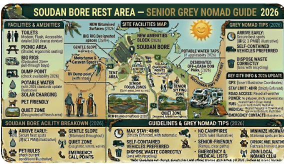
Quick Facts and Key Details 2026
| Detail | Information |
|---|---|
| Location | Barkly Highway, Northern Territory |
| Postcode | 0862 |
| GPS Coordinates | -19.9167° S, 136.5833° E (approx. — confirm on-device) |
| Highway | Barkly Highway (A2) |
| Cost | Free |
| Max Stay | 24 hours (NT guideline) |
| Toilets | Yes — pit/drop toilets on site |
| Showers | No |
| Potable Water | No — self-sufficient required |
| Powered Sites | No |
| Dump Point | No — nearest at Tennant Creek |
| Shade | Limited — bring your own shade setup |
| Surface | Gravel/compacted dirt parking area |
| Road to Site | Sealed highway — unsealed pull-off area |
| Caravan Access | Yes — suitable for large rigs |
| Nearest Town West | Tennant Creek (~185 km west) |
| Nearest Town East | Camooweal, QLD (~220 km east) |
| Phone Signal | Very limited to none — satellite device recommended |
| WiFi | None |
| Managed By | NT Department of Infrastructure, Planning and Logistics |
How to Get to Soudan Bore Rest Area + GPS
📍 GPS Coordinates — Soudan Bore Rest Area
-19.9167° S, 136.5833° E
Coordinate source: Publicly available mapping data. Always confirm coordinates on your own device before travelling. Coordinates are approximate for this remote location.
Address for navigation: Barkly Highway, NT 0862 — search “Soudan Bore Rest Area” in your preferred GPS app.
Driving Directions — From Tennant Creek (West)
From Tennant Creek, head east on the Barkly Highway (A2). The highway is fully sealed and well-maintained for its class. Soudan Bore Rest Area is located approximately 185 km east of Tennant Creek. The rest area is signed on both sides of the highway — watch for the standard NT rest area signage well in advance, as speed is high and pull-off time can be short.
Driving Directions — From Camooweal, QLD (East)
If travelling west from Queensland, enter the NT via the Barkly Highway from Camooweal. Soudan Bore Rest Area is approximately 220 km west of Camooweal. Again, watch for signed turnoffs — the rest area is set slightly off the highway proper on a gravel pull-off.
Vehicle Suitability
- Caravans and fifth-wheelers: Suitable — turning space is adequate for most standard configurations
- Motorhomes: Suitable — all sizes
- Road trains and heavy vehicles: Yes — this stop is specifically designed as a truck rest area as well
- 2WD campervans: Suitable — the highway is fully sealed and the pull-off is compacted gravel
- 4WD not required to access this rest area
Road Conditions, Flooding and Unsealed Sections
Barkly Highway — Surface Conditions
The Barkly Highway is a sealed bitumen highway for its entire length between Tennant Creek and Camooweal. The road surface is generally in reasonable condition for an outback highway, though sections can develop corrugations, rough patches, and heat-related surface damage during extreme temperatures.
The rest area pull-off at Soudan Bore is a compacted gravel and dirt surface. During rain, this surface can become slippery and muddy. If you arrive during wet conditions, drive into the rest area slowly and be aware that soft edges can cause bogging.
Check Road Conditions Before You Travel
- NT Road Conditions: nt.gov.au — NT Road Conditions
- Bureau of Meteorology: bom.gov.au — NT Weather Forecasts
- QLD Road Conditions (if crossing border): qld.gov.au/transport road conditions
Unsealed Road Sections Nearby
The Barkly Highway itself remains sealed. However, if you intend to explore any station tracks or off-highway routes in this region, you will encounter unsealed roads very quickly. These tracks are 4WD only in the wet season and should not be attempted without adequate recovery gear, communication devices, and local knowledge.
Heat and Remoteness — Senior Safety on the Barkly
The Barkly Tablelands is genuinely remote, and the heat here can be extreme. Summer temperatures regularly exceed 40°C, and ground-level radiant heat makes it feel significantly hotter. There is minimal shade at Soudan Bore Rest Area — the open Mitchell grass plains offer almost none naturally.
Heat Safety Checklist
- Carry a minimum of 10 litres of drinking water per person above your normal supply
- Fit external shade options — awning, shade cloth, windscreen reflectors
- Know the signs of heat stroke: confusion, dry skin, rapid heartbeat, no sweating
- Have a functioning 12V fan or portable air conditioning unit in your rig
- Plan travel for early morning (depart by 7am to avoid peak heat periods)
- Do not leave pets or passengers in an unventilated vehicle under any circumstances
- Carry emergency electrolyte sachets in your first aid kit
Remoteness — Distances and Self-Sufficiency
At Soudan Bore, you are genuinely remote. The nearest town with services (Tennant Creek) is approximately 185 km west. Camooweal in Queensland is approximately 220 km east. There is no fuel, no water, no shop, and no mechanic within reach. You must be fully self-sufficient for at least one to two days’ supplies as a minimum safety buffer.
Mobile phone coverage is extremely limited to non-existent at this location. See the Phone Signal section below for details on emergency communication options.
Wildlife — Birds, Reptiles and What to Watch For
The Barkly Tablelands is home to a surprising variety of wildlife despite its seemingly barren appearance. The Mitchell grass plains support large populations of birds, reptiles, and mammals that have adapted to this harsh environment.
Birds
- Brolgas — often seen in pairs or small groups near water sources after rain
- Bustards (Australian Bustard) — large, stately ground-dwelling birds that walk slowly across open plains
- Raptors — wedge-tailed eagles, black kites, and brown falcons are common overhead
- Zebra finches and budgerigars — small flocks often gather at any available water source
- Owls — barn owls and grass owls hunt at dusk and dawn along the highway verges
Reptiles
- Goannas (monitor lizards) — common around rest areas, particularly where food scraps may attract them
- Various skinks and dragons — bask on gravel surfaces, especially in the morning
- Snakes — king browns (mulga snakes) and western browns are present in this region. Always watch where you step, especially at dawn and dusk.
Kangaroos and Livestock — Road Hazard
Red kangaroos are extremely common in this region and represent a serious road hazard, particularly at dawn, dusk, and night. Cattle can also be found on or near the unfenced highway. Do not drive after dark if avoidable. If you must drive at night, reduce your speed and use high beam carefully.
What Other Websites Don’t Tell You About Soudan Bore
🔍 Real Information — Not Just a Dot on the Map
Most online resources list Soudan Bore Rest Area as simply a lat/lng coordinate with “toilets available” noted. Here’s what they typically leave out:
- Road trains don’t slow down. Even when you are stationary at the rest area, passing road trains generate significant wind blast. Ensure awnings are secured before you sleep.
- The bore itself is historic but not accessible to visitors as an active water source. Do not rely on bore water — it is not potable for human consumption.
- Shade is the #1 missing commodity. There are no trees at most Barkly rest areas. A quality awning and shade sail setup is not optional in summer — it is critical.
- Flies are relentless from around September through to May. A fly net for your hat and a good fly screen setup on your van are worth their weight in gold.
- Dust can be significant even during the dry season, particularly when road trains pass. Keep dust-sensitive equipment stowed and seal your van as best you can.
- Night sky viewing is exceptional. With zero light pollution and a clear horizon in all directions, the Milky Way is stunning from this location on clear nights. Bring a red-light torch for stargazing.
Best Time to Visit — Month-by-Month Breakdown
| Month | Season | Conditions | Grey Nomad Suitability |
|---|---|---|---|
| January | Wet Season | Extreme heat, storms, possible flooding | ⚠️ Not recommended |
| February | Wet Season | Hot, humid, flood risk remains | ⚠️ Not recommended |
| March | Wet Season end | Conditions improving, still hot | ⚠️ Caution — check road conditions |
| April | Transition | Cooling, drying roads, fresh green plains | ✅ Good — early birds catch the green |
| May | Dry Season | Pleasant temperatures, low humidity | ✅ Excellent |
| June | Dry Season | Cool nights, warm days — peak travel | ✅ Excellent — busiest period |
| July | Dry Season | Cool nights can reach near 5–8°C | ✅ Excellent — warmth layers needed at night |
| August | Dry Season | Slightly warming, still very comfortable | ✅ Excellent |
| September | Dry Season end | Warming rapidly, flies increasing | ✅ Good — early morning travel advised |
| October | Build-up begins | Hot, humidity building, flies bad | ⚠️ Caution — heat management critical |
| November | Pre-wet | Very hot, storm potential increasing | ⚠️ Not recommended for seniors |
| December | Wet Season | Storms, extreme heat, flooding risk | ⚠️ Not recommended |
Best months to visit: May, June, July, and August offer the most comfortable conditions on the Barkly. Grey nomad traffic peaks in June and July — expect to share the rest area with several other vans during these months.
Free and Low-Cost Camping Nearby
The Barkly Highway has a network of rest areas and free stops that most nomads string together as part of a staged crossing. Here are the key options near Soudan Bore:
Northern Territory Rest Area Network — Barkly Highway
These rest areas form part of a reliable free and low-cost stopping network across the Barkly and surrounding NT highways. Plan your fuel and water carefully between each stop.
- Wonarah Bore Rest Area — free camp on the Barkly Highway
- Avon Downs Rest Area — Barkly Tablelands free stop
- Frewena Rest Stop — small outback service stop
- 41 Mile Bore Rest Area — Barkly Highway stop
- Newcastle Waters Rest Area — historic droving town stop
Dump Points Near Soudan Bore Rest Area
There is no dump point at Soudan Bore Rest Area. This is a basic roadside rest area without waste disposal infrastructure.
| Location | Direction | Distance | Notes |
|---|---|---|---|
| Tennant Creek — Caravan Park dump points | West | ~185 km | Multiple caravan parks offer dump facilities — small fee may apply for non-guests |
| Camooweal, QLD | East | ~220 km | Camooweal Caravan Park — check availability on arrival |
Use Campermate.com.au or the Campermate app to locate the most current dump point information for Tennant Creek and surrounding areas.
Free Water Sources Near Soudan Bore
The distances between water sources on the Barkly Highway are significant. Senior travellers should carry a minimum of 40–60 litres of fresh drinking water before leaving Tennant Creek heading east, or leaving Camooweal heading west. This is not a guideline — in summer, it can be a life-saving requirement.
| Water Source | Direction | Distance | Type |
|---|---|---|---|
| Tennant Creek — town water/caravan parks | West | ~185 km | Town supply — reliable |
| Frewena (limited) | West — varies | Approx highway position | Roadhouse — small supply — verify before relying on it |
| Camooweal, QLD | East | ~220 km | Town water — reliable |
Fuel Stops Along the Barkly Highway
Fuel planning is critical on the Barkly Highway. Distances between reliable fuel sources are substantial, and not all roadhouses operate 24 hours or guarantee stock. Always fill up wherever fuel is available.
| Fuel Stop | Direction from Soudan Bore | Approx. Distance | Notes |
|---|---|---|---|
| Tennant Creek | West | ~185 km | Multiple fuel options — most reliable supply on this route |
| Frewena Roadhouse | West (highway position varies) | ~130–150 km (approx.) | Basic roadhouse — fuel availability should be confirmed — limited hours |
| Barkly Homestead Roadhouse | East | ~80–100 km (approx.) | Roadhouse with fuel, basic supplies, and accommodation — a key stop on the Barkly |
| Camooweal, QLD | East | ~220 km | Town with multiple fuel options |
Caravan Parks — Paid Alternatives Near Soudan Bore
If you prefer powered sites, full amenities, or simply want a proper shower and dump point, the two nearest caravan park options are in Tennant Creek (west) and Camooweal (east, QLD).
| Park | Location | Direction | Distance | Approx Cost (2026) |
|---|---|---|---|---|
| Tennant Creek Caravan Parks (multiple) | Tennant Creek, NT | West | ~185 km | $35–$55/night powered |
| Barkly Homestead Roadhouse | Barkly Highway, NT | East | ~80–100 km | Basic camping available — check current rates on site |
| Camooweal Drovers Camp | Camooweal, QLD | East | ~220 km | ~$30–$45/night — iconic stop on the Barkly route |
Free campsites and powered sites fill fast during school holidays and peak season. If your preferred site is already taken, search remaining accommodation options for Tennant Creek and the surrounding Barkly region.
Accommodation search powered by Expedia. Booking through this search supports this website at no extra cost to you. As an affiliate, I earn from qualifying purchases.
Full Facilities Comparison Table
| Facility | Soudan Bore Rest Area | Barkly Homestead (~100 km E) | Tennant Creek Parks (~185 km W) |
|---|---|---|---|
| Cost | Free | Paid | Paid ($35–$55) |
| Toilets | ✅ Pit toilets | ✅ Full amenities | ✅ Full amenities |
| Showers | ❌ No | ✅ Yes | ✅ Yes |
| Potable Water | ❌ No | ✅ Yes | ✅ Yes |
| Power | ❌ No | ✅ Some sites | ✅ Yes |
| Dump Point | ❌ No | Check on site | ✅ Yes |
| Fuel | ❌ No | ✅ Yes | ✅ Yes |
| Food/Shop | ❌ No | ✅ Limited | ✅ Full range |
| Shade | ⚠️ Minimal | ✅ Some | ✅ Some |
| Phone Signal | ❌ Very limited | ⚠️ Limited | ✅ Yes |
| Caravan Access | ✅ Yes | ✅ Yes | ✅ Yes |
Rates — All Options Near Soudan Bore 2026
| Option | 2026 Rate | Notes |
|---|---|---|
| Soudan Bore Rest Area | Free | 24-hour maximum stay guideline |
| Wonarah Bore Rest Area | Free | Similar basic facilities |
| Barkly Homestead camping | Check on arrival | Roadhouse camp — basic |
| Tennant Creek caravan parks | $35–$55/night | Powered sites, full facilities |
| Camooweal Drovers Camp | ~$30–$45/night | Iconic stop — verify rates on arrival |
Senior Safety Checklist — On and Off the Road
- Fuel tank full before leaving Tennant Creek or Camooweal
- Minimum 40–60 litres fresh drinking water on board
- Satellite communication device charged and activated (EPIRB or PLB registered)
- Responsible person notified of your planned route and expected arrival time
- First aid kit including heat illness treatments and electrolytes
- Medications for minimum 3 days beyond planned itinerary
- Spare tyre (more than one is recommended in this region)
- Tyre repair kit and compressor on board
- Recovery gear — snatch strap, high-lift jack, boards
- Fly nets for hats and fly screens for the van
- Awning and shade sail setup for rest periods
- Road conditions checked via NT roads authority before departure
- BOM weather check completed for next 48 hours
- Vehicle mechanically checked — tyres, coolant, oil, battery
- Phone signal expectations confirmed — satellite device or HF radio available
What to Do Near Soudan Bore — Senior Activity Guide
Soudan Bore is not a destination in the tourism sense — it is a strategic rest stop on a very long highway. But that doesn’t mean there’s nothing to experience here.
Stargazing
With zero light pollution and a perfectly flat horizon in all directions, the night sky at Soudan Bore is extraordinary. The Milky Way is visible with the naked eye on clear, moonless nights. Bring a red-light torch (preserves night vision) and a star map app on a device with offline capability.
Birdwatching at Dawn
The Mitchell grass plains come alive with bird activity around sunrise. Set up a chair outside and watch for bustards, brolgas, and raptors in the early morning light. Binoculars are recommended.
Nearby Tennant Creek (185 km West)
- Tennant Creek Battery Hill Mining Centre — fascinating gold mining history, accessible for seniors
- Pebbles (Kunj) — a smaller but impressive collection of rounded granite boulders, a sacred Aboriginal site
- Devil’s Marbles (Karlu Karlu) — approximately 100 km south of Tennant Creek — one of Australia’s great outback icons, sunrise and sunset visits highly recommended
- Tennant Creek town markets — when operating, a good chance to stock up on fresh produce
Nearby Camooweal, QLD (220 km East)
- Camooweal Caves National Park — extraordinary karst cave system accessible from the town — day trips available
- Georgina River — birdwatching, fishing, and photography along the river flats
- Drovers Camp — the famous droving history of the region is well documented at the Drovers Camp facilities in town
🗺️ Vanlife Savings Spots — GPS Coordinates and Postcodes
Save every free stop, rest area, and overnight pull-off along the Barkly Highway and across Australia using the RetireToVanLife interactive map tool. Pin Soudan Bore and nearby stops to plan your route before you leave home.
COPY PROMPT ➔ ASK AI ➔ SAVE TO FORM ➔ ADD SPOT PIN ➔ GET DIRECTIONS
📍 Interactive map — find free camps, rest areas and overnight stops across Australia. Enable location for best results.
| Stop Name | Postcode | Latitude | Longitude | Notes |
|---|---|---|---|---|
| Soudan Bore Rest Area | 0862 | -19.9167 | 136.5833 | Free — pit toilets — no water |
| Wonarah Bore Rest Area | 0862 | -19.8833 | 136.0000 | Free — basic — Barkly Highway |
| Avon Downs Rest Area | 0862 | -19.9833 | 136.8833 | Free — Barkly Tablelands |
| Barkly Homestead Roadhouse | 0862 | -19.7000 | 135.8333 | Paid camping — fuel — food |
| Frewena Rest Stop | 0862 | -19.4000 | 135.9333 | Basic stop — verify facilities |
Note: Coordinates for remote NT locations are approximate based on publicly available mapping data. Always verify on your own device before travel. Coordinate source: open mapping databases.
Phone Signal and Emergency Communications
Emergency Communication Options
- Personal Locator Beacon (PLB) — registered with AMSA (Australian Maritime Safety Authority). A PLB is a mandatory item for outback travel in our view. They activate a satellite-based rescue response. Registration is free at beacons.amsa.gov.au
- Satellite Messenger (Garmin inReach, SPOT) — allows two-way messaging and SOS activation via satellite. Subscription required.
- HF Radio — traditional outback communication tool. Requires licence and setup but works where nothing else does.
- Starlink (vehicle-mounted) — increasingly used by grey nomads for broadband satellite internet connectivity. Works well in open outback locations.
Nearest Emergency Services
- Police — Tennant Creek: (08) 8962 4444
- Emergency (all services): 000
- Royal Flying Doctor Service: Available via PLB activation or satellite communication
Campfires, Cooking Restrictions and Food Purchases
Campfires
Open campfires are not encouraged at roadside rest areas along the Barkly Highway. During the dry season, the Mitchell grass is highly flammable and fire risk is significant. A portable gas stove or camp oven using gas is the recommended cooking method.
Cooking and Food Supplies
There are no food purchase options at Soudan Bore Rest Area. The nearest options for resupply are:
- Barkly Homestead Roadhouse (~80–100 km east) — basic food and snacks available
- Tennant Creek (~185 km west) — full supermarket facilities
- Camooweal (~220 km east) — basic store supplies
Carry sufficient food for at least two full days more than your planned itinerary as a safety buffer. Non-perishable foods, snack bars, dried goods, and long-life dairy are ideal for outback travel.
Pets at Soudan Bore Rest Area
Pets are permitted at NT roadside rest areas. There are no fenced areas, so keep dogs on a lead at all times. The open Mitchell grass plains can look inviting for a dog to run — but snakes, heat, and the proximity to a fast highway make off-lead exercise genuinely dangerous here.
Cats must be contained at all times in the NT. Releasing cats or allowing them to roam is both illegal and harmful to native wildlife in this region.
Accessibility for Seniors with Mobility Limitations
Soudan Bore Rest Area is a basic roadside stop. It is not a fully accessible facility in a modern disability-access sense, but it does offer reasonable accessibility for seniors with mild to moderate mobility limitations.
- Parking surface: Compacted gravel — generally firm enough for walking frames and wheelchairs in dry conditions
- Toilet access: Pit toilets — not purpose-built for wheelchair users, but accessible for most seniors
- Flat terrain: The Barkly Tablelands is genuinely flat — no slopes or grades to navigate
- No kerbs or steps between parking area and toilet facilities in most rest area layouts
- High-sided vehicles (motorhomes) may need extra steps — ensure your step is stable on gravel
Permits, Fees, Etiquette and Waste Management
Permits and Fees
No permits or fees are required to use Soudan Bore Rest Area. It is a free, publicly accessible NT government rest area.
Etiquette — Leave No Trace on the Barkly
- Pack out all rubbish. There may be basic bins at some rest areas, but do not rely on them. Carry a rubbish bag and take everything with you.
- Do not dispose of grey water or toilet waste on the ground at the rest area. Use your onboard waste management systems.
- Respect other travellers — keep generators off during quiet hours and be mindful of noise and lights in overnight situations
- Do not block access to the toilet facilities or the highway pull-off entry/exit points
Waste Management
- Grey water: Contain and dispose at appropriate dump points — do not discharge at rest areas
- Black water: Cassette or tank — dump only at designated dump points (Tennant Creek or Camooweal)
- Rubbish: Pack and carry to next town facility
Emergency Scenarios — What to Do
Scenario 1: Medical Emergency
If a medical emergency occurs at Soudan Bore and you have no phone signal, activate your PLB or satellite messenger immediately. The Royal Flying Doctor Service operates in this region and can respond to properly activated beacons. If you can reach phone signal, dial 000.
Scenario 2: Breakdown on the Highway
If your vehicle breaks down, pull completely off the highway if possible. Use hazard lights and set out warning triangles. Do not attempt to walk along the highway — road train speeds make this extremely dangerous. Activate your PLB or satellite messenger and wait for assistance. A passing driver may be able to relay a message at the next point of phone coverage.
Scenario 3: Flash Flooding
If heavy rain begins and water starts rising across the highway, do not attempt to cross flooded sections. Turn back to higher ground and wait. Floodwater on the Barkly can rise rapidly and is often much deeper than it appears. This is a genuine life-threatening risk — no schedule is worth a flood crossing.
Scenario 4: Vehicle Bogged
If you drive onto soft ground adjacent to the rest area during or after rain and become bogged, do not spin wheels excessively — this makes the situation worse. Use recovery gear (snatch strap, boards) if you have it. If not, wait and signal for help from a passing truck or 4WD.
Packing List for This Section of the Barkly Highway
- Minimum 60 litres fresh drinking water
- Full fuel tank — fill at last opportunity
- PLB or satellite communicator (charged)
- First aid kit — heat illness treatments, bandages, pain relief
- Medications — 3+ days beyond planned itinerary
- Non-perishable food for 2 extra days
- Spare tyre (two recommended)
- Tyre repair kit and compressor
- Recovery gear — snatch strap, boards, high-lift jack
- Jumper cables or battery jump pack
- Awning and shade sail
- Fly nets and fly screens
- Gas camp stove and fuel canisters
- Torch and spare batteries (red-light torch for stargazing)
- Road atlas — paper backup for NT/QLD Barkly region
- Dustproof storage for cameras and electronics
- Electrolyte sachets
- Insect repellent
- Snake bite bandage kit
- Warmth layers — Barkly nights can be cold in winter
5 Nearby Rest Areas — Barkly Highway Network
| Rest Area | Direction | Approx. Distance | Cost | Toilets |
|---|---|---|---|---|
| Wonarah Bore Rest Area | West | ~60 km | Free | Yes |
| Avon Downs Rest Area | East | ~50 km | Free | Yes |
| Frewena Rest Stop | West | ~130 km | Free | Basic |
| 41 Mile Bore Rest Area | West | ~150 km+ | Free | Yes |
| Newcastle Waters Rest Area | West | ~200+ km | Free | Yes |
If you’re travelling through the Northern Territory, these rest areas form part of a reliable network of free and low-cost stops across major outback highways. From the Stuart Highway to the Barkly and Victoria Highway routes, these locations are popular with caravanners, road trippers, and long-haul drivers.
- Attack Creek Rest Area — Stuart Highway
- 41 Mile Bore Rest Area — Barkly Highway
- Bonney Well Rest Stop — NT Outback
- Newcastle Waters Rest Area — free camping
- King Rest Area — caravans and trucks
- Limestone Creek Rest Area — overnight stop
- King West Rest Area — highway break
- Noel Buntine Memorial Rest Area
- Sullivan Campground Rest Area
- East Baines Rest Area — Victoria Highway
- Beef Road Monument Rest Area
- Avon Downs Rest Area — Barkly Tablelands
- Frewena Rest Stop
- Wonarah Bore Rest Area — free camp
Reviews — What Grey Nomads Say About Soudan Bore
“We pulled in around 3pm on our way east from Tennant Creek. Clean toilet, quiet spot, and the road trains didn’t bother us much overnight. The flies during the day were something else though — thank goodness for fly nets. Would stop here again as part of a staged Barkly crossing.”
“Functional and free — which is exactly what you need out here. Don’t expect anything fancy. No shade trees, basic pit toilet, and no water. But as a sleep stop on a very long highway, it does the job. The stars at night were absolutely stunning — best sky I’ve seen in years.”
“People who skip this stop and try to push straight through the Barkly in one shot are taking unnecessary risks. We stopped here, had a three-hour rest, cooked dinner, and watched the most incredible sunset over the Mitchell grass. Set off at dawn the next morning completely refreshed. This is how you do the Barkly safely.”
Frequently Asked Questions — Soudan Bore Rest Area
Is Soudan Bore Rest Area free to stay at?
Yes. Soudan Bore Rest Area is a free NT government rest area. No fees, no booking, and no permits are required. The maximum stay guideline is 24 hours.
Are there toilets at Soudan Bore Rest Area?
Yes. Pit or drop toilets are available at the rest area. There are no flush toilets, showers, or other amenities.
Is there water at Soudan Bore Rest Area?
No. There is no potable water available. You must carry all your own drinking water. The bore water on site is not suitable for human consumption.
Can caravans and motorhomes use Soudan Bore Rest Area?
Yes. The rest area is accessible to caravans, motorhomes, campervans, and heavy vehicles. The pull-off is compacted gravel and the area provides adequate turning room for most standard rig configurations.
Does the Barkly Highway flood?
Yes. During the wet season (November to March/April), sections of the Barkly Highway can flood, particularly at creek crossings. Always check current road conditions via the NT roads authority before travelling. Never attempt to cross flooded sections of the highway.
Is there phone coverage at Soudan Bore Rest Area?
Mobile phone coverage is extremely limited to non-existent. Do not rely on mobile connectivity here. Carry a PLB, satellite messenger, or HF radio for emergency communication.
Where is the nearest fuel to Soudan Bore?
The nearest reliable fuel is at Barkly Homestead Roadhouse (approximately 80–100 km east) or Tennant Creek (approximately 185 km west). Always fill your tank before departing from either direction.
Where is the nearest dump point to Soudan Bore?
The nearest dump points are in Tennant Creek (approximately 185 km west) or Camooweal, QLD (approximately 220 km east). Use Campermate.com.au to locate current dump facilities.
What time of year is best to visit?
May through August offers the most comfortable conditions. June and July are peak grey nomad travel months on the Barkly. Avoid the wet season (November–March) due to extreme heat, flooding risk, and road closures.
How far is Soudan Bore from Tennant Creek?
Soudan Bore Rest Area is approximately 185 km east of Tennant Creek on the Barkly Highway.
⚡ Quick-Reference Card — Soudan Bore Rest Area
| Location | Barkly Highway, NT 0862 |
| GPS | -19.9167° S, 136.5833° E (approx.) |
| Cost | Free — 24hr max stay |
| Toilets | Yes — pit toilets |
| Water | No potable water on site |
| Dump Point | No — nearest Tennant Creek or Camooweal |
| Phone Signal | Very limited to none |
| Nearest Fuel (West) | Tennant Creek ~185 km |
| Nearest Fuel (East) | Barkly Homestead ~80–100 km |
| Best Months | May, June, July, August |
| Road Condition Check | nt.gov.au — NT Roads |
| Emergency | 000 / PLB / Satellite Messenger |
| Managed By | NT Dept Infrastructure, Planning & Logistics |
🔒 Protect Your Van in Remote Locations
Get 5% OFF all StarterStopper immobiliser products with promo code: RTV5
Visit StarterStopper.com — data-backed vehicle security solutions
As an affiliate, I earn from qualifying purchases at no extra cost to you.
RV LIFE Trip Wizard — USA-Based RV Trip Planning Tool
RV LIFE Trip Wizard is a USA-based RV trip planning tool designed for American RV travellers. If you’re visiting Australia from the USA and want to plan your home country RV trips, this tool is worth exploring.

As an affiliate, I earn from qualifying purchases at no extra cost to you.
© 2026 RetireToVanLife.com — All rights reserved. Written for Senior Grey Nomads. Safe travels. 🚐