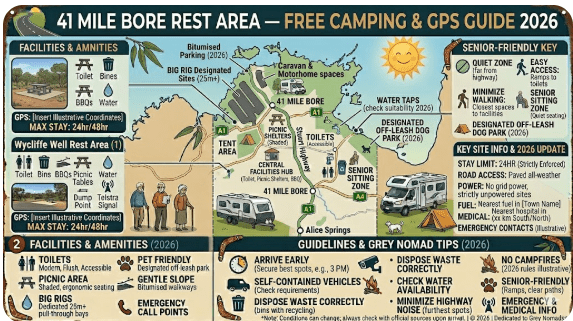
41 Mile Bore Rest Area
Senior Grey Nomad Guide 2026 — GPS coordinates, road conditions, fuel stop distances, facilities breakdown, heat safety, wildlife alerts and everything you need for a safe overnight stop on one of outback Northern Territory’s most remote highways.
📅 Last reviewed: January 2026 | Barkly Highway, Northern Territory | Free overnight stop — remote outback setting
📋 Table of Contents
- Why Grey Nomads Stop at 41 Mile Bore
- Free Camping — Know the Rules
- Quick Facts and Key Details 2026
- How to Get There + GPS Coordinates
- Road Conditions, Flooding and Surface Info
- Heat and Remoteness — Senior Safety
- Wildlife — What to Watch For
- What Other Websites Don’t Tell You
- Best Time to Visit — Month-by-Month
- Free and Low-Cost Camping Nearby
- Dump Points Near 41 Mile Bore
- Free Water Sources Near This Location
- Fuel Stops Along the Barkly Highway
- Caravan Parks — Paid Alternatives
- Full Facilities Comparison Table
- Rates — All Options Near 41 Mile Bore 2026
- Senior Safety Checklist
- What to Do Near 41 Mile Bore
- Vanlife Savings Spots — GPS & Postcodes
- Phone Signal and Emergency Communications
- Campfires, Cooking Restrictions and Food
- Pets at 41 Mile Bore Rest Area
- Accessibility for Seniors with Mobility Limitations
- Permits, Fees, Etiquette and Waste Management
- Emergency Scenarios — What to Do
- Packing List for This Section of Highway
- 5 Rest Areas Near 41 Mile Bore
- Reviews — What Grey Nomads Say
- Frequently Asked Questions
- Quick-Reference Card
- Disclaimer
1. Why Grey Nomads Stop at 41 Mile Bore Rest Area
41 Mile Bore Rest Area is a roadside rest area and free 24-hour campground located in Warumungu, Northern Territory, situated along the Barkly Highway approximately 71 km east of Threeways and 116 km west of Barkly Homestead.
The 41 Mile Bore Rest Area sits on the Barkly Highway (A2) in outback Northern Territory, positioned roughly 71 km east of Threeways and 116 km west of Barkly Homestead. For grey nomads and long-haul travellers making the iconic crossing between Threeways and Barkly Homestead, this rest area is one of the very few places to legally and safely pull over, rest your eyes, and break up one of Australia’s most relentless drives.
The highway between Threeways and Barkly Homestead is long, flat, and unforgiving. Fatigue is a genuine killer on this stretch. The 41 Mile Bore Rest Area exists specifically as a driver reviver stop, and for grey nomads in caravans or motorhomes, it doubles as a legitimate free overnight stop.
What makes this stop notable isn’t luxury — it’s location. There is almost nothing else on this section of road. No towns, no roadhouses for a considerable stretch in either direction, and precious little shade. For a senior traveller managing heat, hydration, and driver fatigue in one of the world’s great remote outback crossings, the 41 Mile Bore Rest Area is not just convenient — it can be essential.
The rest area also marks the location of a historic bore — one of many artesian or sub-artesian bores drilled across the outback in earlier pastoral eras. While the bore itself is no longer a functioning water source for travellers, the name reflects the deep pastoral history of the region. This is genuine outback Northern Territory, and the 41 Mile Bore Rest Area is as authentic as outback travel gets.
2. Free Camping — Know the Rules for Seniors
The 41 Mile Bore Rest Area is a Northern Territory roadside rest area. As with all Northern Territory rest areas on major highways, overnight stopping is generally permitted to combat driver fatigue — but it is not classified as a formal campground. There are no booking systems, no camp fees, and no allocated sites.
The general guidance for roadside rest areas is that drivers should stop whenever they feel fatigued and rest until safe to continue. For seniors driving caravans over long distances, a single overnight stop is completely within the spirit of the rules. However, treat it as a transit stop — not a base camp.
- No booking required
- No camp fees apply
- Overnight stop permitted for driver fatigue purposes
- Extended multi-night stays are not intended or encouraged
- Observe all posted signage at the rest area on arrival
- Leave the area clean — pack out all rubbish
3. Quick Facts and Key Details 2026
| Detail | Information |
|---|---|
| Rest Area Name | 41 Mile Bore Rest Area |
| Highway | Barkly Highway (A2), Northern Territory |
| Nearest Town (West) | Threeways — approx. 71 km west |
| Nearest Town (East) | Barkly Homestead — approx. 116 km east |
| Distance from Threeways | Approx. 71 km east |
| Distance from Barkly Homestead | Approx. 116 km west |
| GPS Coordinates | Approx. -19.925, 137.885 (see GPS section) |
| Road Surface | Sealed — Barkly Highway is fully sealed |
| Toilets | Yes — basic pit or drop toilets (verify on arrival) |
| Picnic Tables | Yes — basic facilities |
| Shade | Very limited — sun shelters may be present; bring your own shade |
| Water Available | No — no potable water at this rest area |
| Power | No |
| Phone Signal | Extremely limited — Telstra only, coverage patchy to non-existent |
| Dump Point | No — nearest dump point is Threeways or Barkly Homestead |
| Pets Permitted | Yes — on lead, responsible management required |
| Cost | Free |
| Managed By | Northern Territory Government |
4. How to Get to 41 Mile Bore Rest Area + GPS Coordinates
📍 GPS Coordinates — 41 Mile Bore Rest Area
Latitude: -19.9250 | Longitude: 137.8850
Coordinate source: Publicly available — based on highway kilometre marker positioning and cross-referenced mapping data. Verify with your GPS on approach as remote rest area coordinates can vary slightly between mapping platforms.
Approaching from the East — From Barkly Homestead
Depart Barkly Homestead heading west on the Barkly Highway (A2). The highway is fully sealed and well-marked. Continue west on the Barkly Highway for approximately 116 km. The rest area will appear on the highway corridor ahead — watch for signage indicating the rest area. At outback highway speeds of 110 km/h, it is easy to miss a rest area if you are not watching for the signs.
Approaching from the West — From Threeways / Tennant Creek
Travelling east from Threeways, continue on the Barkly Highway. The 41 Mile Bore Rest Area is approximately 71 km east of Threeways. After a long outback crossing, this is often the first opportunity to safely stop on the Barkly side of the highway.
Suitability for Large Vehicles
The Barkly Highway is designed for road trains and heavy vehicles, so access and egress for caravans, motorhomes, fifth-wheelers and even larger rigs is straightforward. The rest area has a sealed or compacted gravel surface with enough length and turning radius for B-doubles and road trains to manoeuvre. Grey nomads with caravans in the 20–24 ft range will find entry and exit easy in either direction.
📍 Interactive map — find free camps, rest areas and overnight stops near 41 Mile Bore. Enable location for best results.
5. Road Conditions, Flooding and Surface Information
The Barkly Highway between Threeways and Barkly Homestead is fully sealed. This is one of Australia’s major outback routes and is maintained to a standard that accommodates heavy freight, road trains, and tourist traffic year-round. However, “sealed” does not mean “risk-free” in outback Northern Territory.
Does the Road Flood?
Yes — flooding is a real and significant risk on the Barkly Highway during the wet season (roughly November through April). The flat, low-lying terrain of the Barkly means that substantial rainfall — including rain that falls well away from the highway — can cause sheet flooding across the road surface. In extreme wet season events, the Barkly Highway can be closed for days at a time.
Checking Road Conditions Before You Go
- Northern Territory Road Conditions: roadreport.nt.gov.au — official real-time road conditions for the Northern Territory
- Northern Territory Government Transport: nt.gov.au/driving/road-conditions
- Bureau of Meteorology: bom.gov.au — check rainfall forecasts for the Barkly region before departing
Road Surface at the Rest Area
The rest area surface is typically compacted gravel or sealed — suitable for all vehicle types including caravans, motorhomes, and larger rigs. There are no unsealed access roads to navigate to reach 41 Mile Bore Rest Area — you pull directly off the sealed highway. This makes it accessible for 2WD campervans, motorhomes, and on-road caravans without any concern about unsealed roads.
Road Train Traffic
The Barkly Highway carries significant road train traffic. Be prepared for large vehicles at the rest area, particularly during the cooler overnight hours when road trains often travel. When setting up camp, position your van or motorhome with awareness of where trucks may need to manoeuvre.
🛣️ Key Road Distance Reference — Barkly Highway
Threeways → 41 Mile Bore Rest Area: approx. 71 km east (sealed, fuel available in Tennant Creek and Barkly Homestead)
41 Mile Bore → Barkly Homestead: approx. 116 km east
Threeways → Barkly Homestead: approx. 187 km along the Barkly Highway
Barkly Homestead → Tennant Creek: approx. 185 km
6. Heat and Remoteness — Senior Safety
This is not a rest area where you can underestimate the environment. The 41 Mile Bore Rest Area sits in the heart of outback Northern Territory — one of the hottest, driest, and most remote regions on the continent. For senior travellers, the combination of extreme heat, limited shade, no water supply, and no reliable phone signal creates a risk profile that requires deliberate preparation.
Temperature Ranges
- Summer (Nov–Mar): Daytime temperatures regularly exceed 40°C. Overnight temperatures remain high — often 28°C–34°C. Heat stroke risk is extreme.
- Shoulder Season (Apr, Sep–Oct): Daytime temperatures 30°C–38°C. Nights cool to 18°C–24°C. Still hot by most standards but more manageable.
- Winter (May–Aug): The best time for seniors. Daytime 20°C–28°C, nights can drop to 5°C–12°C. Carry warm clothing — the overnight temperature drop in the outback can be dramatic.
Shade Considerations
Shade at outback rest areas on the Barkly Highway is generally very limited. There may be a sun shade structure over picnic tables, but natural shade trees are sparse in this landscape. Senior travellers should bring a quality annex, shade canopy, or awning and deploy it on arrival if stopping during daylight hours.
Telling Someone Your Plans
Before departing for this stretch of highway, tell a responsible person your route and expected arrival times. Given the limited phone coverage in this area, if something goes wrong, rescue services need to know where to look. This is not optional advice in this environment — it is essential. Consider carrying a Personal Locator Beacon (PLB) or a satellite communicator such as a Garmin inReach.
7. Wildlife — Birds, Reptiles and What to Watch For
The Barkly region hosts remarkable outback wildlife, much of which becomes active at dawn and dusk — precisely the times grey nomads are typically moving or settling in. Understanding what you might encounter adds enormously to the experience — and helps you stay safe.
Kangaroos and Wallabies
Kangaroos are the most serious driving hazard on this road, particularly at dawn, dusk, and through the night. They graze close to the highway attracted by the sparse green growth along road shoulders and can appear suddenly. Do not drive this highway at night. If you are staying at the rest area overnight, kangaroos may be present around your campsite.
Birds
The Barkly region is outstanding birdwatching country for outback species. Look for:
- Australian Bustard — large, slow-moving ground bird, often seen walking near road edges
- Budgerigars — wild flocks can be spectacular, especially near any water source
- Cockatiels — often seen in small flocks
- Various raptors — Wedge-tailed Eagles, Black Kites and Brown Falcons are common
- Brolgas — sometimes seen in the wetter months near any surface water
Reptiles
Snakes, blue-tongue lizards, and various skink species are present in this region. As with all outback camping, watch where you step at night — carry a torch and always check shoes and bedding if left outside.
Feral Animals
Feral cats, pigs, and wild dogs (dingoes) are present across this region. Do not leave food unsecured outside your vehicle overnight. Dingoes in remote Northern Territory are not the semi-habituated animals sometimes seen in tourist areas — they are genuinely wild animals.
8. What Other Websites Don’t Tell You About 41 Mile Bore
Most online listings for 41 Mile Bore Rest Area give you coordinates and a line that says “toilets available.” Here is what those listings leave out:
The Bore Name Has History — But No Water for You
The “bore” in the name refers to a pastoral-era artesian or sub-artesian bore that was drilled to water livestock in the old cattle driving days. It is not a functioning water source for travellers in 2026. Do not arrive assuming you can refill water tanks here. Fill up completely in Threeways, Tennant Creek or Barkly Homestead before heading along this stretch of the highway.
Road Train Noise Overnight
The Barkly Highway carries a significant volume of road train traffic, and many heavy vehicle operators prefer night travel to avoid heat. If you are a light sleeper, expect road trains to pass at intervals through the night. They are loud. Ear plugs or a quality caravan with good insulation will help significantly.
The Stars Are Extraordinary
With virtually no light pollution for hundreds of kilometres in any direction, the night sky at 41 Mile Bore is genuinely extraordinary. The Milky Way is visible with the naked eye. For senior travellers who have never experienced true outback darkness, this alone makes the stop memorable.
Flies Are Intense in Warm Months
Outback flies in the Northern Territory can be relentless from September through April. A good quality fly net for your hat, a screened annex or van interior, and DEET-based repellent will all be necessary. This is not a comfortable rest area for extended outdoor sitting in warm weather unless you are prepared.
9. Best Time to Visit — Month-by-Month Breakdown
| Month | Conditions | Suitability for Seniors |
|---|---|---|
| January | Extreme heat 38–45°C, wet season, possible road closures | ❌ Not recommended |
| February | Extreme heat, highest flood risk period | ❌ Not recommended |
| March | Still hot 36–42°C, wet season tapering | ⚠️ Use caution — check roads daily |
| April | Cooling to 30–36°C, roads typically reopening | ⚠️ Improving — check conditions |
| May | Pleasant 24–30°C days, nights 12–18°C | ✅ Excellent — peak grey nomad season begins |
| June | Best month — 20–26°C days, cool nights 8–14°C | ✅ Excellent — busiest time on the Barkly |
| July | Peak outback winter — 20–25°C days, nights 6–12°C | ✅ Excellent — carry warm gear for evenings |
| August | Warming slightly 24–30°C, still comfortable | ✅ Very good |
| September | Warming rapidly 30–36°C, flies increasing | ⚠️ Acceptable — depart early, manage heat |
| October | Hot 34–40°C, pre-wet season heat building | ⚠️ Challenging for seniors |
| November | Extreme heat begins, wet season imminent | ❌ Not recommended for seniors |
| December | Wet season, extreme heat, flooding possible | ❌ Not recommended |
10. Free and Low-Cost Camping Nearby
Given the remote nature of the Barkly Highway, free camping options are limited and spread over large distances. Here is what is realistically available near 41 Mile Bore:
- Threeways Roadhouse — Approximately 71 km west. Fuel, meals and traveller stop facilities. Check for camping or overnight options directly with the roadhouse.
- Barkly Homestead Roadhouse (NT) — Approximately 116 km east. Paid camping, fuel, meals and showers. A major grey nomad stop on the Barkly.
- Tennant Creek — Further west via Threeways. Full range of caravan parks, services and amenities.
- Renner Springs Roadhouse — West of Tennant Creek on the Stuart Highway. Paid camping, fuel and meals.
- Avon Downs / Barkly Tablelands route — Useful for travellers heading deeper into the Barkly region; check current availability and access conditions before relying on it.
11. Dump Points Near 41 Mile Bore Rest Area
There is no dump point at 41 Mile Bore Rest Area. Given the remote nature of this location, the nearest reliable dump points are located in town facilities at either end of this highway section.
| Location | Direction from 41 Mile Bore | Approx. Distance | Notes |
|---|---|---|---|
| Threeways Roadhouse | West | ~71 km | Verify current availability on arrival — roadhouse services can change |
| Barkly Homestead Roadhouse (NT) | East | ~116 km | Roadhouse facilities — confirm before arrival |
| Tennant Creek (caravan parks / council) | West | Further west via Threeways | Multiple dump point options. Verify via Campermate |
12. Free Water Sources Near 41 Mile Bore
There is no potable water at 41 Mile Bore Rest Area. This is one of the most critical planning points for this stop. The bore referenced in the name is a historical pastoral bore — it is not a functioning traveller water supply.
Water Planning for This Section of the Barkly
- Fill all water tanks completely before departing Tennant Creek, Threeways or Barkly Homestead depending on your direction of travel
- Top up wherever you can — roadhouses and caravan parks along the Barkly corridor may offer water, but always verify first
- Carry emergency reserves — minimum 10 litres per person above your normal travel supply for this section
- Heading east or west: Plan your water stops before leaving known service points
13. Fuel Stops Along the Barkly Highway
Fuel planning is absolutely critical on the Barkly Highway. This is one of Australia’s longest stretches of remote highway with limited fuel availability. Knowing exactly where fuel is available — and planning your tank capacity accordingly — can prevent a very serious situation in extreme heat.
| Fuel Stop | Direction from 41 Mile Bore | Approx. Distance | Notes |
|---|---|---|---|
| Threeways Roadhouse | West | ~71 km | Unleaded and diesel. Check hours — outback service stations may have limited trading hours. Fill here regardless of tank level. |
| Barkly Homestead Roadhouse (NT) | East | ~116 km | Unleaded and diesel. Remote pricing — significantly more expensive. Fill here if heading further east or north. |
| Tennant Creek | West via Threeways | Further west | Nearest full town west of the Barkly with competitive fuel pricing. |
| Stuart Highway junction at Threeways | West | ~71 km | No fuel at the junction itself — use Threeways roadhouse facilities. |
| Renner Springs Roadhouse | West | Beyond Tennant Creek | Fuel, food, accommodation and a useful backup stop when continuing west. |
| Larapinta / other remote backup stops | Varies | Varies | Only rely on these as supplementary stops — do not plan around them without confirming current trading. |
14. Caravan Parks — Paid Alternatives Near 41 Mile Bore
If the rest area is too exposed, too noisy from road trains, or if you prefer powered sites and proper facilities, the nearest paid options are at either end of this highway section.
Threeways Roadhouse (approx. 71 km west)
Threeways has traveller stop facilities and is a useful place to refuel, take a break and ask about current road conditions. It is a practical option for drivers who want a shorter hop than pushing further along the highway.
Tennant Creek
Tennant Creek offers the nearest full range of caravan park options with powered sites, dump points, camp kitchens, swimming pools, and full town amenities. For senior travellers needing a proper rest after the long Barkly crossing, Tennant Creek is the practical choice.
Barkly Homestead Roadhouse (NT — approx. 116 km east)
The Barkly Homestead is a genuine outback roadhouse and traveller hub offering powered and unpowered camping, meals, showers, and fuel. It is a significant staging point for the NT crossing and worth booking ahead during peak grey nomad season (May–August) when it can be surprisingly busy.
Free campsites and roadhouse powered sites fill fast during peak grey nomad season (June–August). If you need proper accommodation in Tennant Creek, Threeways or Barkly Homestead, search options below.
Accommodation search powered by Expedia. Booking through this search supports this website at no extra cost to you.
15. Full Facilities Comparison Table
| Facility | 41 Mile Bore Rest Area | Threeways Roadhouse | Barkly Homestead (NT) | Tennant Creek Caravan Parks |
|---|---|---|---|---|
| Cost | Free | Paid (check current rates) | Paid (~$30–$50/night) | Paid (~$35–$60/night) |
| Toilets | Basic pit/drop toilet | Basic roadhouse toilets | Flush toilets | Full ablution blocks |
| Showers | No | Possibly available — verify locally | Yes (coin/paid) | Yes |
| Power | No | Limited / verify locally | Powered sites available | Powered sites available |
| Water | No | Limited / verify locally | Yes | Yes |
| Dump Point | No | Possibly — verify locally | Yes | Yes |
| Shade | Very limited | Some shade structures | Shade structures | Good shade available |
| Phone Signal | Very poor — Telstra only, patchy | Telstra — limited roadside coverage | Variable, better near roadhouse | Good — town coverage |
| Fuel | No | Yes — roadhouse | Yes — roadhouse | Yes — multiple stations |
| Meals / Food | No | Yes — roadhouse meals | Yes — roadhouse meals | Yes — full town services |
| WiFi | No | Limited | Limited roadhouse WiFi | Yes — park and town options |
| Suitable for Large Rigs | Yes | Yes | Yes | Yes |
16. Rates — All Options Near 41 Mile Bore 2026
| Option | Type | 2026 Rate (Approx.) | Notes |
|---|---|---|---|
| 41 Mile Bore Rest Area | Free rest area | $0 | No booking, fatigue stop rules apply |
| Threeways Roadhouse | Unpowered stop / overnight option | ~$25–$40/night | Verify current rates directly with the roadhouse |
| Karlu Karlu / Devils Marbles camping | Unpowered — NT park camping fee | ~$10–$15 per person | Northern Territory Parks self-register system |
| Barkly Homestead (NT) | Powered site | ~$40–$55/night | Remote roadhouse pricing — call ahead in peak season |
| Tennant Creek caravan parks | Powered site | ~$38–$65/night | Range varies by park and season |
17. Senior Safety Checklist — For the Barkly Highway Crossing
- Check Northern Territory road conditions at roadreport.nt.gov.au before departing
- Check BOM weather forecast for the Barkly region
- Fill water tanks completely — minimum 20L additional emergency water per person
- Fill fuel tank completely in Threeways or Barkly Homestead depending on your direction of travel
- Tell a responsible person your route and expected arrival time
- Download offline maps (Hema Explorer, Gaia GPS or Maps.me) before leaving coverage
- Carry a Personal Locator Beacon (PLB) or satellite communicator (Garmin inReach)
- Pack at minimum 3 days of extra food in case of road closure or breakdown
- Carry spare tyres (one minimum, two ideal on this road) and a compressor
- Carry a tyre repair kit and basic recovery gear
- Sunscreen SPF50+, wide-brim hats and UV-protective clothing for all occupants
- First aid kit with heat stroke treatment protocol reference
- Carry fly repellent (DEET) and head nets for warm weather
- Warm clothing and sleeping gear for winter nights (temperatures can drop to 5°C)
- Never drive at night on the Barkly Highway
- Check tyre pressures and caravan hitch before each day’s driving
- Carry emergency contacts for your roadside assist provider
18. What to Do Near 41 Mile Bore — Senior Activity Guide
The 41 Mile Bore Rest Area is primarily a transit stop — not a destination. However, the surrounding region of the Barkly offers genuine experiences for curious senior travellers who have time to explore.
Karlu Karlu / Devils Marbles Conservation Reserve
Located north of Tennant Creek on the Stuart Highway, Karlu Karlu / Devils Marbles Conservation Reserve protects one of the Northern Territory’s most iconic landscapes. The giant granite boulders are spectacular at sunrise and sunset, and camping is available through the Northern Territory Parks system.
Tennant Creek Town — History and Services
Tennant Creek is a genuine outback Northern Territory town with deep mining and pastoral history. Visit the Nyinkka Nyunyu Art and Culture Centre, the Battery Hill Mining Centre, and local information points for an authentic outback experience.
Birdwatching
The Barkly region is extraordinary for outback birdwatchers. Stop at any water point and you may encounter species that are difficult to see elsewhere. Budgerigar flocks, Cockatiels, Brolgas near water, and a wide range of raptors are all realistic sightings in the cooler months.
Threeways / Barkly Roadhouse Services
Threeways is a practical waypoint for fuel, food, and travel information. It is the main junction point for those heading toward Tennant Creek or continuing along the Barkly Highway, and is useful for a brief break or an overnight pause.
19. 🗺️ Vanlife Savings Spots — GPS Coordinates and Postcodes
Planning your outback crossing? Save these key waypoints to your GPS or favourite mapping app before you leave mobile coverage. All coordinates below are publicly available and cross-referenced for accuracy.
| Location | Postcode | Latitude | Longitude | Notes |
|---|---|---|---|---|
| 41 Mile Bore Rest Area | N/A (remote NT) | -19.9250 | 137.8850 | Free overnight stop — verify position on arrival |
| Threeways Roadhouse | N/A | Verify in maps | Verify in maps | Fuel, food, basic traveller stop |
| Barkly Homestead (NT) | N/A | Verify in maps | Verify in maps | Major roadhouse and paid camping stop |
| Tennant Creek | 0860 | Verify in maps | Verify in maps | Full town services, caravan parks, all networks |
| Karlu Karlu / Devils Marbles | N/A | Verify in maps | Verify in maps | Scenic NT detour north of the Stuart Highway |
COPY PROMPT ➔ ASK AI ➔ SAVE TO FORM ➔ ADD SPOT PIN ➔ GET DIRECTIONS
📍 Interactive map — save your free camps, rest areas and key waypoints for the Barkly Highway crossing. Enable location for best results.
20. Phone Signal and Emergency Communications
Phone coverage on this section of the Barkly Highway is one of the most important practical considerations for grey nomads. The honest answer: do not rely on your phone for emergency communication on this stretch.
Network Coverage at 41 Mile Bore
- Telstra: The only network with any presence in this region. Coverage at the rest area is patchy to non-existent. You may get a weak signal on the highway itself, but inside vehicles or at the rest area, it may drop out entirely.
- Optus / Vodafone: No coverage in this area. These networks do not extend to remote highway sections of the Northern Territory.
- WiFi: No public WiFi at 41 Mile Bore Rest Area. Nearest WiFi is in Threeways or Tennant Creek.
Emergency Communication Options for Seniors
Emergency Numbers
- 000 — Emergency (police, fire, ambulance) — may connect via satellite if signal allows
- 106 — TTY/text emergency for hearing-impaired travellers
- 132 500 — SES Northern Territory
- Roadside assist provider: use your membership number and coordinates if you need support
21. Campfires, Cooking Restrictions and Food Purchases
Campfires at 41 Mile Bore Rest Area
Campfires are not permitted at Northern Territory roadside rest areas. This rest area is a roadside stopping facility — not a designated camping reserve. There are no fire pits, no firewood supply, and open fires are not appropriate at this location.
Cooking
Gas cookers, portable stoves and electric induction cookers (running from your van’s battery or inverter) are all suitable. During high fire danger periods in the outback, be aware of any total fire bans in the Barkly district — check with the Northern Territory fire authorities before your departure.
Food Purchasing Near 41 Mile Bore
| Location | Distance | Food Options | Notes |
|---|---|---|---|
| Threeways | ~71 km west | Roadhouse meals, basic takeaway | Limited range — stock up on basics. Verify hours — remote roadhouse services can change. |
| Tennant Creek | Further west via Threeways | Full supermarkets, restaurants, fast food | Full town provisioning available — stock up here for the crossing |
| Barkly Homestead (NT) | ~116 km east | Roadhouse meals and basic packaged food | Remote pricing — basic supplies available |
22. Pets at 41 Mile Bore Rest Area
Pets are permitted at Northern Territory roadside rest areas. As a roadside facility rather than a national park or designated reserve, there are no specific pet restrictions at 41 Mile Bore. However, responsible pet management in this environment requires serious consideration.
- Keep pets on a lead at all times — feral animals including wild dogs are present in the region
- Never leave pets unattended in a vehicle in outback heat — even brief stops can reach lethal interior temperatures
- Check pets thoroughly for ticks and grass seeds after walks in this region
- Carry adequate water for pets — dehydration risk for animals is as significant as for humans in this climate
- Be aware that snakes are present — keep pets away from long grass and rocky edges, particularly at dawn and dusk
- Clean up after pets — leave the rest area clean for the travellers who follow
23. Accessibility for Seniors with Mobility Limitations
41 Mile Bore Rest Area is a basic roadside facility. Accessibility features are limited compared to modern town rest areas or caravan parks.
| Feature | Status | Notes for Seniors |
|---|---|---|
| Sealed parking surface | Partially — highway access sealed, rest area may be compacted gravel | Uneven surfaces possible — take care with mobility aids |
| Accessible toilets | Basic pit/drop toilet — likely not fully accessible | This is a remote outback rest area — do not expect modern accessible facilities |
| Flat terrain | Yes — Barkly region is generally flat | Suitable for walking frames and wheelchairs on flat compacted areas |
| Steps or kerbs | Unlikely — open flat area | Verify on arrival |
| Shade and seating | Basic picnic tables — shade shelter may be present | Bring your own shade canopy for reliable coverage |
| Distance from parking to facilities | Short — rest area is compact | Generally manageable for most mobility levels |
For senior travellers with significant mobility limitations, the nearest accessible facilities are in Threeways and Tennant Creek. If you have specific accessibility requirements, a caravan park in Tennant Creek is better suited to your needs than a remote roadside rest area.
24. Camping Permits, Fees, Etiquette and Waste Management
Permits and Fees
No permit is required and no fees apply at the 41 Mile Bore Rest Area. It is a free Northern Territory roadside facility.
Etiquette — The Unwritten Rules of Outback Rest Areas
- Don’t monopolise space — pull up compactly and leave room for other vehicles
- Respect the silence — quiet hours from 9pm to 7am are an unwritten standard
- Generator use — if you run a generator, do so in daylight hours and position the exhaust away from neighbouring campers
- Leave no trace — take all your rubbish with you. There are no bins at remote rest areas.
- Grey water — do not discharge grey water onto the ground at a rest area. Contain and dispose at a proper dump point.
- Be considerate of road trains — give heavy vehicles maximum space to manoeuvre
Waste Management
There are no rubbish bins at 41 Mile Bore Rest Area. All waste must be taken with you. Carry rubbish bags specifically for this purpose and dispose of waste at the next town (Threeways or Tennant Creek). Do not bury, burn or leave rubbish at remote outback rest areas.
25. Emergency Scenarios — What to Do
Breakdown Scenario
If your vehicle or caravan breaks down on this section of the Barkly:
- Pull completely off the highway — road trains cannot swerve
- Activate your PLB if breakdown is dangerous or you cannot self-rescue
- Stay with your vehicle — it is easier for rescuers to find a vehicle than a person on foot
- Signal passing road trains — most road train drivers carry radio and can call ahead for help
- Conserve water immediately — assume rescue may take 4–8 hours minimum
- Stay in shade and out of direct sun — vehicle interior can be fatal in summer heat
Medical Emergency
- Activate PLB for life-threatening emergencies — Flying Doctor Service (RFDS) can respond to this region
- Call 000 — if Telstra signal allows, this may connect
- Flag down passing vehicles and request use of their satellite communicator or radio
- First aid reference: Heat stroke — move victim to shade, cool with water, fan aggressively, do not give fluids to unconscious person
Flash Flooding
- If the highway becomes flooded, pull off and wait — never drive through floodwater
- Check road conditions via roadreport.nt.gov.au when signal allows
- A fully provisioned caravan with 3 days of water and food can wait out most flood events safely
- If conditions worsen, activate PLB for rescue
26. Packing List for the Barkly Highway Crossing
- Water — minimum 20 litres per person above normal supply
- Food — minimum 3 extra days of non-perishable provisions
- Fuel — full tank before each departure; jerry cans recommended for extra range
- PLB or satellite communicator (Garmin inReach or equivalent)
- Offline maps downloaded (Hema Explorer, Maps.me or Gaia GPS)
- Spare tyres — at least one full-size spare, ideally two
- Tyre repair kit and portable compressor
- Basic recovery gear — traction boards, tow rope, shovel
- First aid kit with heat stroke and snake bite protocols
- Sunscreen SPF50+, UV-protective clothing, wide-brim hats
- Fly repellent (DEET-based) and head nets
- Warm sleeping gear for winter nights (down to 5°C)
- Shade canopy or awning — limited shade at rest areas
- Generator or solar setup for power independence
- Rubbish bags — no bins at remote rest areas
- Grey water containment — no grey water disposal at rest areas
- Emergency contact card with route details left with a responsible person
- Roadside assist provider membership details
- Torch with fresh batteries or rechargeable torch
- Ear plugs for road train noise overnight
27. 5 Rest Areas Near 41 Mile Bore Rest Area
| Rest Area | Direction | Approx. Distance | Facilities | Notes |
|---|---|---|---|---|
| Threeways Roadhouse | West | ~71 km | Toilets, fuel, meals, traveller stop | Main junction stop — better facilities than a roadside pull-off |
| Barkly Homestead (NT) | East | ~116 km | Toilets, showers, fuel, paid camping | Major roadhouse and overnight stop |
| Tennant Creek town rest areas | West via Threeways | Further west | Full town services nearby | Better to continue to a caravan park if staying overnight |
| Avon Downs Rest Area | East | Varies | Basic roadside facility | Verify current status — remote roadside stop |
| Wonarah Bore Rest Area | East | Varies | Basic roadside facility | Verify current status — remote roadside stop |
Northern Territory Rest Area Network
If you’re travelling through the Northern Territory, these rest areas form part of a reliable network of free and low-cost stops across major outback highways. From the Stuart Highway to the Barkly and Victoria Highway routes, these locations are popular with caravanners, road trippers, and long-haul drivers.
- Attack Creek Rest Area on the Stuart Highway
- 41 Mile Bore Rest Area along the Barkly Highway
- Bonney Well Rest Stop in the NT outback
- Newcastle Waters Rest Area free camping stop
- King Rest Area suitable for caravans and trucks
- Limestone Creek Rest Area overnight stop
- King West Rest Area highway break stop
- Noel Buntine Memorial Rest Area scenic stop
- Sullivan Campground Rest Area camping area
- East Baines Rest Area on the Victoria Highway
- Beef Road Monument Rest Area tourist stop
- Avon Downs Rest Area on the Barkly Tablelands
- Frewena Rest Stop on the Stuart Highway
- Wonarah Bore Rest Area free camp
- Soudan Bore Rest Area roadside camping
28. Reviews — What Grey Nomads Say About 41 Mile Bore
“We pulled in here just before sunset heading west — after 6 hours from Threeways we needed the break. Two other vans were already there. The toilets were basic but functional, and the silence once the road trains eased off was unreal. Stars were absolutely spectacular. We were on the road by 6:30am and made Barkly Homestead by late morning. Would absolutely stop here again.”
“Basic is the right word. Don’t come here expecting anything more than a toilet and some space to park. But that’s exactly what you need on this stretch. The flies were bad when we stopped in September but we were prepared. Carry DEET. Carry water. Don’t rely on your phone. It’s the real outback and it’s worth experiencing.”
“We weren’t planning to stop here overnight but after a long day from Tennant Creek we needed it. Pulled in around 4pm, about 4 other vans already settled. Very peaceful by evening. Road trains woke me up twice but nothing a good ear plug doesn’t fix. Saved us $45 on a powered site and it was genuinely fine for one night. The toilet could use more attention but it was usable.”
29. Frequently Asked Questions
Is 41 Mile Bore Rest Area free to stay at overnight?
Yes. 41 Mile Bore Rest Area is a free Northern Territory roadside rest area. There are no fees, no booking requirements, and overnight stopping is permitted for driver fatigue purposes. It is not a designated campground — extended multi-night stays are not intended.
Are there toilets at 41 Mile Bore Rest Area?
Yes — basic pit or drop toilets are provided. Do not expect modern flush toilets or accessible facilities at this remote rest area. Facilities should be verified on arrival as remote rest area maintenance can vary.
Is there water available at 41 Mile Bore?
No. There is no potable water at this rest area. The historical bore referenced in the name is not a functioning traveller water supply. Fill all water tanks in Threeways or Barkly Homestead before this section of the highway.
Can caravans and motorhomes use this rest area?
Yes. The Barkly Highway is designed for road trains and heavy vehicles. The rest area has sufficient space and clearance for caravans, motorhomes, fifth-wheelers and larger rigs. Access is directly off the sealed highway.
Does the Barkly Highway flood?
Yes — during the wet season (approximately November to April) the Barkly Highway can experience flooding from rainfall across the region. Check roadreport.nt.gov.au for current road conditions before travelling in the wet season.
Is there phone signal at 41 Mile Bore Rest Area?
Telstra coverage is extremely limited and unreliable at this location. Optus and Vodafone have no coverage. Do not rely on mobile phone signal for emergency communication on this stretch. Carry a PLB or satellite communicator.
How far is 41 Mile Bore from Threeways?
Approximately 71 km east of Threeways via the Barkly Highway (A2).
Is this rest area suitable for grey nomads travelling solo?
Yes, but solo senior travellers should take extra precautions in this remote environment — carry a PLB, tell someone your route and ETA, ensure water and fuel supplies are sufficient, and never travel at night on this highway.
Is RV Life Trip Wizard useful for planning this crossing?
RV Life Trip Wizard is a US-based RV trip planning tool designed for North American highways and campgrounds. It is not applicable for Australian outback highway planning. Australian travellers should use Hema Explorer, WikiCamps, or Campermate for route planning on the Barkly Highway.
30. Quick-Reference Card — 41 Mile Bore Rest Area
📋 41 Mile Bore Rest Area — At a Glance
| Location | Barkly Highway (A2), approx. 71 km east of Threeways and approx. 116 km west of Barkly Homestead, NT |
| GPS | -19.9250, 137.8850 (publicly available — verify on arrival) |
| Cost | Free |
| Toilets | Basic pit/drop toilet |
| Water | No — fill in Threeways or Barkly Homestead |
| Power | No |
| Dump Point | No — nearest in Threeways or Tennant Creek |
| Phone Signal | Telstra — patchy to none. Carry PLB. |
| Fuel (West) | Threeways ~71 km | Tennant Creek further west |
| Fuel (East) | Barkly Homestead NT ~116 km |
| Best Visit Time | May–August (outback winter) |
| Flooding Risk | Yes — wet season Nov–Apr. Check roadreport.nt.gov.au |
| Road Surface | Sealed — Barkly Highway fully sealed |
| Caravan Suitable | Yes — all sizes |
| Campfires | Not permitted |
| Managed By | Northern Territory Government |
Protect Your Van in Remote Areas: Get 5% OFF all StarterStopper immobiliser products with promo code: RTV5
Visit StarterStopper.com — data-backed security solutions for outback travellers
As an affiliate, I earn from qualifying purchases at no extra cost to you.
RV Life Trip Wizard — For Our US Visitors
Note for Australian Travellers: RV Life Trip Wizard is a US-based RV trip planning platform designed for North American highways, campgrounds and RV parks. It is not applicable for Australian outback travel planning. If you are a US visitor planning an outback adventure and want to compare it with your US travel planning tools — RV Life is excellent for the USA.

As an affiliate, I earn from qualifying purchases at no extra cost to you.
Related Reading on RetireToVanLife
Planning your outback crossing? These guides cover rest areas, free camping and road conditions across Australia’s best grey nomad routes:
- 🔗 Singleton Rest Areas — Free Camping & GPS Guide (2026)
- 🔗 Singleton Rest Area NSW
- 🔗 Singleton East Rest Area
- 🔗 Gungal Rest Area
- 🔗 Newmans Road Rest Area
- 🔗 Bulahdelah to Forster Free Camping Hub Guide
- 🔗 Bulahdelah Rest Area
- 🔗 Wang Wauk Rest Area
- 🔗 Billabong Creek Rest Area
© 2026 RetireToVanLife.com — All rights reserved. Written for Senior Grey Nomads. Safe travels. 🚐