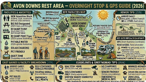
Avon Downs Rest Area
Senior Grey Nomad Guide 2026 — GPS coordinates, road conditions, fuel stops, Barkly Highway distances, facilities, wildlife and everything you need for a safe and comfortable overnight stop on the Barkly Tablelands.
📅 Last reviewed: May 2026 | Barkly Highway, NT 0862 | Free overnight rest area — remote outback setting
📋 Table of Contents
- Why Grey Nomads Stop at Avon Downs
- Free Camping — Know the Limits
- Quick Facts and Key Details 2026
- How to Get There + GPS
- Road Conditions, Flooding and Unsealed Sections
- Heat and Remoteness — Senior Safety
- Wildlife — Birds, Reptiles and What to Watch For
- What Other Websites Don’t Tell You
- Best Time to Visit — Month-by-Month
- Free and Low-Cost Camping Nearby
- Dump Points Near Avon Downs
- Free Water Sources
- Fuel Stops Along the Barkly Highway
- Caravan Park — Paid Alternatives
- Full Facilities Comparison Table
- Rates — All Options 2026
- Senior Safety Checklist
- What to Do Near Avon Downs
- Vanlife Savings Spots — GPS & Postcodes
- Phone Signal and Emergency Communications
- Campfires, Cooking and Food Nearby
- Pets at Avon Downs
- Accessibility for Seniors
- Permits, Fees, Etiquette and Waste
- Emergency Scenarios — What to Do
- Packing List for the Barkly Highway
- 5 Nearby Rest Areas on the Barkly Highway
- Reviews — What Grey Nomads Say
- Frequently Asked Questions
- Quick-Reference Card
- Disclaimer
Why Grey Nomads Stop at Avon Downs Rest Area
The Avon Downs Rest Area is a free, 24-hour roadside stop located along the Barkly Highway in the Northern Territory, situated approximately 70 km west of Camooweal and 190 km east of Barkly Homestead. It is best known as a safe overnight point for long-haul travellers due to its location directly opposite the Avon Downs Police Station.
The Barkly Tablelands is one of Australia’s most iconic but demanding drives. Distances between services are enormous, the heat is extreme, and fatigue can set in quickly. The Avon Downs Rest Area provides a genuine pause point — a place to rest, stretch, brew a cup of tea, and, if needed, spend a safe night before continuing west toward Tennant Creek or east toward Mount Isa.
The area takes its name from Avon Downs Station, a large cattle property in the region. The tablelands themselves are cattle country on a grand scale, with open grassland stretching to the horizon in every direction. There are no towns, no shopping centres, no distractions — just highway, sky, and the quiet satisfaction of crossing one of Australia’s great outback routes.
First-hand observation: Pulling in around 4pm on a weekday in the dry season, we counted four caravans and two camper trailers already parked up. By sunset, several more had arrived. The flat, open setting means there is no shade, but the wide parking area gives everyone plenty of room to spread out and enjoy the extraordinary outback sky.
Free Camping — Know the Limits for Seniors
The Avon Downs Rest Area is a Northern Territory Government-managed rest area on the Barkly Highway. Overnight stays are generally permitted as part of the NT’s rest area network, which is designed to support driver fatigue management across remote highways.
There are no fees to use this rest area. It is a free, publicly accessible stopping point on a public highway. However, facilities are basic — do not expect powered sites, dump points, or potable water on-site.
For seniors travelling on a budget, the NT’s rest area network along the Barkly Highway is one of the best free camping networks in Australia. Plan your distances carefully and use these stops strategically.
Quick Facts and Key Details 2026
| Detail | Information |
|---|---|
| Location | Barkly Highway, Avon Downs area, NT 0862 |
| GPS Coordinates | -19.9833° S, 136.7667° E (approx.) |
| Highway | Barkly Highway (A2) |
| Road Surface | Sealed highway — rest area on sealed/gravel hardstand |
| Cost | Free |
| Overnight Stays | Permitted (fatigue management — approx. 24hr guideline) |
| Toilets | Yes — basic pit or composting toilet on-site |
| Potable Water | Not available — carry your own |
| Dump Point | Not on-site — nearest at Tennant Creek or Mount Isa |
| Power | No |
| Shade | Minimal — open tablelands setting |
| Mobile Signal | Very limited — Telstra only, patchy coverage |
| Distance to Tennant Creek | Approx. 250 km west |
| Distance to Mount Isa | Approx. 200 km east |
| Heavy Vehicles | Yes — suitable for road trains and large rigs |
| Caravans | Yes — wide sealed/gravel area |
| Pets | Permitted — no specific restrictions noted |
| Nearest Fuel | Camooweal (QLD) approx. 120 km east; Barkly Homestead approx. 80 km west |
How to Get There + GPS
📍 GPS Coordinates — Avon Downs Rest Area
-19.9833° S, 136.7667° E
Coordinate source: Publicly available mapping data (approximate — verify with current mapping apps before travel).
Address reference: Barkly Highway, Avon Downs NT 0862
Driving Directions
The Avon Downs Rest Area is located on the Barkly Highway (A2), the major sealed highway connecting Tennant Creek (NT) in the west with Mount Isa (QLD) in the east.
- From Tennant Creek (west): Head east on the Barkly Highway. The rest area is approximately 250 km from Tennant Creek, shortly before or near the Avon Downs Station turnoff. Travel time is approximately 2.5–3 hours depending on road conditions and traffic.
- From Mount Isa (east): Head west on the Barkly Highway through Camooweal. After crossing the NT border, continue approximately 130 km further west. Travel time from Mount Isa is approximately 2–2.5 hours.
- From Three Ways Roadhouse (north/south junction): Three Ways is approximately 290 km west of Avon Downs via Tennant Creek. If you are travelling from Darwin or Alice Springs on the Stuart Highway, turn east at Three Ways onto the Barkly Highway.
Real traveller note: We entered the rest area from the eastbound direction, and found the entry and exit well-signed and easy to navigate even with a 20-foot caravan. The sealed highway gives a clean run on approach, and the rest area itself is wide enough for road trains to pull through separately from caravans and campers. The turning radius is generous — no tricky manoeuvres required.
Vehicle Suitability
| Vehicle Type | Suitability | Notes |
|---|---|---|
| 2WD car/SUV | ✅ Suitable | Sealed highway access |
| Caravan (up to 8m) | ✅ Suitable | Wide area, easy entry/exit |
| Large motorhome/RV | ✅ Suitable | Plenty of hardstand space |
| Road train / truck | ✅ Suitable | Designed for heavy vehicles |
| Camper trailer | ✅ Suitable | No off-road access required |
| 4WD + off-road van | ✅ Suitable | Highway stop only |
Road Conditions, Flooding and Unsealed Sections
The Barkly Highway itself is fully sealed from Mount Isa to Tennant Creek, and the Avon Downs Rest Area is accessed directly from the sealed highway. There are no unsealed roads required to reach this rest area. This makes it accessible to all vehicle types, including 2WD vehicles, caravans, and large motorhomes.
Seasonal Road Conditions
| Season | Condition | Risk Level |
|---|---|---|
| Dry season (May–Oct) | Excellent — sealed, smooth, clear | Low |
| Wet season (Nov–Apr) | Flooding possible at crossings — check before travel | High if flooded |
| Post-rain (any month) | May have localised flooding or road damage | Moderate |
Always check current road conditions before crossing the Barkly Tablelands during or after rain events. Use the official NT road condition reporting service:
- NT Road Report (roadreport.nt.gov.au) — real-time NT road conditions
- Bureau of Meteorology (bom.gov.au) — outback weather forecasts
Heat and Remoteness — Senior Safety
The Barkly Tablelands is one of the hottest and most remote regions in Australia. Temperatures regularly exceed 40°C in summer (November–March), and the flat, treeless landscape offers virtually no natural shade. For senior travellers, this environment demands careful planning.
Practical Heat Management Tips
- Travel during early morning and late afternoon — avoid driving during peak heat (10am–3pm) in summer
- Carry a minimum of 10 litres of drinking water per person above your normal requirements when crossing the Barkly
- Set up shade using your caravan awning or shade cloth — there are no trees at this rest area
- Use reflective window covers to reduce heat build-up inside your van or motorhome
- Never leave pets or children in a vehicle in outback heat
- Check in with a responsible person before and after crossing the Barkly Tablelands — give them your planned route and expected arrival time
Wildlife — Birds, Reptiles and What to Watch For
Despite its sparse, flat appearance, the Barkly Tablelands supports a surprising variety of wildlife. The grasslands are habitat for a range of birds, reptiles, and mammals — many of which are active at dawn, dusk, and after dark.
Common Wildlife at and Near Avon Downs
- Brolgas: These large, elegant cranes are iconic on the Barkly. They are commonly seen feeding in grassy areas near water and are a highlight for birdwatchers.
- Budgerigars: In good seasons, vast flocks of wild budgerigars sweep across the tablelands — a genuinely spectacular sight.
- Australian Bustard (Bush Turkey): Often seen walking slowly across the plains or road verges.
- Brown Snakes and King Browns: Present throughout the region. Always watch where you step, particularly at dusk and after dark. Shake out shoes and check under your vehicle before entering.
- Goannas: Large monitor lizards are common. They are generally not aggressive but can move surprisingly fast.
- Kangaroos and Wallabies: Active at dawn and dusk — an extremely serious road hazard on the Barkly Highway. Drive slowly after sunset.
- Cattle: Open range cattle country — stock can wander onto the highway at any time of day or night.
What Other Websites Don’t Tell You About Avon Downs Rest Area
The Real Picture — Honest Outback Insights
Most online guides simply list this rest area as “a stop on the Barkly Highway” and move on. Here’s what the standard tourist information leaves out:
- Road trains dominate this area at night. The Barkly Highway is a major freight route. Road trains pass throughout the night and their noise and vibration can disturb light sleepers. Ear plugs are worthwhile. They typically pull into rest areas to take their mandatory break — you may find yourself parked beside one.
- There is almost no natural shade. The tablelands are treeless. If you are stopping in summer and have no awning or shade setup, the rest area will be brutally hot from mid-morning onwards.
- Flies are exceptional in summer and spring. A fly net for your hat is not a luxury here — it is a necessity. If you sit outside during daylight hours between August and December, the fly pressure can be overwhelming without protection.
- The silence at night is profound. Once the road trains settle, the Barkly night sky is one of the darkest and clearest in Australia. Stargazing here is extraordinary — bring a chair and a red-light torch.
- Fuel management is critical. Do not assume you can rely on a roadside service that may be closed or out of fuel. This section of highway has long gaps between reliable fuel points.
Best Time to Visit — Month-by-Month Breakdown
| Month | Season | Temperature | Road Risk | Verdict |
|---|---|---|---|---|
| January | Wet | 38–42°C | High — flooding | ❌ Avoid |
| February | Wet | 38–42°C | High — flooding | ❌ Avoid |
| March | Wet/transition | 36–40°C | Moderate–High | ⚠️ Caution |
| April | Transition | 32–36°C | Low–Moderate | ⚠️ Improving |
| May | Dry | 27–32°C | Low | ✅ Good |
| June | Dry | 23–28°C | Low | ✅ Excellent |
| July | Dry | 22–28°C | Low | ✅ Best month |
| August | Dry | 24–30°C | Low | ✅ Excellent |
| September | Dry | 27–34°C | Low | ✅ Very good |
| October | Build-up | 32–38°C | Low | ⚠️ Hot |
| November | Build-up | 35–40°C | Moderate | ⚠️ Caution |
| December | Wet | 37–42°C | High | ❌ Avoid |
The peak season for grey nomads on the Barkly Highway is June–August. During these months, the rest area is typically well-occupied by late afternoon, with a mix of caravans, camper trailers, solo travellers, and truck drivers. Arriving before 3pm gives you the best choice of position.
Free and Low-Cost Camping Nearby
- Barkly Homestead Rest Area — approx. 80 km west on the Barkly Highway. Small roadhouse with fuel, meals, and basic accommodation. Free rest area alongside.
- Frewena Rest Stop — approx. 130 km west toward Tennant Creek. Free roadside stop on the Barkly Highway. Read the Frewena Rest Stop guide here.
- 41 Mile Bore Rest Area — on the Barkly Highway between Tennant Creek and Three Ways. Free camping with basic facilities. See the 41 Mile Bore Rest Area guide.
- Wonarah Bore Rest Area — free roadside camp on the Barkly Highway. Wonarah Bore Rest Area guide.
- Soudan Bore Rest Area — another free stop along this route. Soudan Bore Rest Area guide.
Dump Points Near Avon Downs Rest Area
| Location | Distance | Dump Point | Notes |
|---|---|---|---|
| Tennant Creek | ~250 km west | ✅ Yes | Multiple options in town |
| Mount Isa | ~200 km east | ✅ Yes | Caravan parks and council facility |
| Camooweal (QLD) | ~120 km east | Limited | Small roadhouse town — check current availability |
| Barkly Homestead | ~80 km west | Possibly | Check with roadhouse staff on arrival |
Use CamperMate (campermate.com.au) to find the most current dump point locations and availability along the Barkly Highway route.
Free Water Sources Near Avon Downs
Carry a minimum of 15–20 litres per person for any Barkly Highway crossing, over and above your normal daily requirements. This is not overcaution — it is basic outback safety. If your vehicle breaks down or you are delayed, adequate water is the difference between a manageable inconvenience and a life-threatening emergency.
Nearest Water Sources
- Barkly Homestead Roadhouse (~80 km west): Water available for purchase or at traveller facilities.
- Camooweal (~120 km east): Town water supply — ask at the roadhouse or service station.
- Tennant Creek (~250 km west): Full town amenities including potable water.
- Mount Isa (~200 km east): Full city amenities.
Fuel Stops Along the Barkly Highway
Fuel planning on the Barkly Highway is serious business. The gaps between reliable fuel stops are among the longest on any sealed highway in Australia. Do not rely on roadhouses being open or having your preferred fuel type. Always fill up at every available opportunity and carry a jerry can as backup.
| Location | Direction | Distance from Avon Downs | Fuel Type | Notes |
|---|---|---|---|---|
| Barkly Homestead Roadhouse | West | ~80 km | ULP, Diesel | Roadhouse — limited hours, check ahead |
| Tennant Creek | West | ~250 km | ULP, Diesel, LPG | Full town — reliable supply |
| Camooweal (QLD) | East | ~120 km | ULP, Diesel | Small town — may have limited stock |
| Mount Isa (QLD) | East | ~200 km | ULP, Diesel, LPG, AdBlue | Major city — full supply |
| Three Ways Roadhouse | West/North | ~290 km via Tennant Creek | ULP, Diesel | Junction of Stuart and Barkly Highways |
Caravan Park — Paid Alternatives
If you prefer powered sites, shower facilities, or dump point access, the nearest caravan parks are in Tennant Creek (west) and Mount Isa (east). The Barkly Homestead Roadhouse also offers basic accommodation and unpowered/powered sites approximately 80 km west of Avon Downs.
| Option | Distance | Cost (approx. 2026) | Features |
|---|---|---|---|
| Avon Downs Rest Area | On-site | Free | Toilets, parking, no power |
| Barkly Homestead Roadhouse | ~80 km west | ~$20–$35/night | Powered/unpowered, meals, fuel |
| Tennant Creek caravan parks | ~250 km west | ~$35–$55/night | Full facilities, dump point, showers |
| Mount Isa caravan parks | ~200 km east | ~$40–$65/night | Full facilities, city amenities |
Full Facilities Comparison Table
| Facility | Avon Downs RA | Barkly Homestead | Tennant Creek |
|---|---|---|---|
| Toilets | ✅ Basic | ✅ Yes | ✅ Full |
| Potable Water | ❌ No | ✅ Yes | ✅ Yes |
| Power | ❌ No | ✅ Powered sites | ✅ Yes |
| Showers | ❌ No | ✅ Yes | ✅ Yes |
| Dump Point | ❌ No | ⚠️ Check locally | ✅ Yes |
| Fuel | ❌ No | ✅ Yes | ✅ Yes |
| Food/Supplies | ❌ No | ✅ Basic meals | ✅ Full supermarket |
| Wi-Fi | ❌ No | ⚠️ Limited | ✅ Yes (town) |
| Mobile Signal | ⚠️ Patchy Telstra | ⚠️ Limited | ✅ Yes |
| Cost | Free | ~$20–$35 | ~$35–$55 |
Rates — All Options Near Avon Downs 2026
| Location | Type | Unpowered | Powered | En-suite |
|---|---|---|---|---|
| Avon Downs Rest Area | Rest Area | Free | N/A | N/A |
| Barkly Homestead | Roadhouse/Camp | ~$20–$25 | ~$30–$35 | N/A |
| Tennant Creek Caravan Parks | Caravan Park | ~$30–$40 | ~$40–$55 | ~$120–$160 |
| Mount Isa Caravan Parks | Caravan Park | ~$35–$45 | ~$50–$65 | ~$130–$180 |
All rates are approximate 2026 estimates. Confirm current pricing directly with each property before arrival.
Senior Safety Checklist — On and Off the Road
- Full tank of fuel before leaving the last fuel stop
- Jerry can with minimum 10 litres additional fuel
- Minimum 20 litres drinking water per person
- Food supplies for at least 2 days beyond planned trip
- Offline maps downloaded — no phone signal on tablelands
- Responsible person notified of your route and ETA
- First aid kit — fully stocked and accessible
- Personal medications — supply for at least 5 extra days
- Satellite communicator (EPIRB, PLB, or Garmin inReach) charged
- Basic vehicle recovery kit — tyre inflator, jump leads
- Sunscreen SPF 50+, wide-brim hat, fly net
- Awning or shade cloth — no natural shade at rest area
- Ear plugs — road train noise at night
- Snake-safe footwear for after-dark movement around site
- Torch with fresh batteries (red-light torch for stargazing)
- BOM weather forecast checked before departure
- NT Road Report checked for flooding or closures
What to Do Near Avon Downs — Senior Activity Guide
Avon Downs is not a destination in itself — it is a strategic rest point on a long outback crossing. That said, the Barkly Tablelands and its surrounding region offer genuine interest for curious travellers.
- Stargazing: The Barkly Tablelands has some of the darkest skies in Australia. On a clear night away from any artificial light, the Milky Way is breathtaking. Set up a camp chair and enjoy one of Australia’s natural wonders.
- Birdwatching: Dawn and dusk are productive times. Brolgas, budgerigars, kites, and ground birds are all possible. Bring binoculars.
- Photography: Flat, open landscape with enormous skies. Sunrise and sunset over the tablelands can produce remarkable colours. The sense of space is unlike anywhere else.
- Chattanooga Lookout (near Camooweal): Approx. 120 km east — Camooweal Caves National Park offers day trips to limestone cave systems. Suitable for most seniors on established walking tracks.
- Tennant Creek (west): The Pebbles, Nobles Nob mine site, battery museum, and local Indigenous art are all worthwhile stops.
- Mount Isa (east): Major city with the Outback at Isa experience, Lake Moondarra, and the world-class Riversleigh fossil fields (UNESCO World Heritage Area) nearby.
🗺️ Vanlife Savings Spots — GPS Coordinates and Postcodes
COPY PROMPT ➔ ASK AI ➔ SAVE TO FORM ➔ ADD SPOT PIN ➔ GET DIRECTIONS
📍 Interactive map — find free camps, rest areas and overnight stops across Australia. Enable location for best results.
| Location | Postcode | Latitude | Longitude | Notes | Nearby WiFi |
|---|---|---|---|---|---|
| Avon Downs Rest Area | 0862 | -19.9833 | 136.7667 | Free overnight — basic toilets | None on-site |
| Barkly Homestead Roadhouse | 0862 | -19.6910 | 135.8340 | Fuel, meals, camping | Limited |
| Frewena Rest Stop | 0862 | -19.8200 | 135.5700 | Free roadside stop | None |
| Tennant Creek township | 0860 | -19.6490 | 134.1913 | Full services, caravan parks | Library WiFi |
| Camooweal (QLD) | 4828 | -19.9238 | 138.1179 | Fuel, basic supplies | Limited |
Phone Signal and Emergency Communications
Emergency Communication Options
- PLB (Personal Locator Beacon): Every outback traveller should carry a registered PLB. If activated, it alerts Australian Maritime Safety Authority (AMSA) who coordinate rescue. Registration is free via AMSA.
- Satellite communicator (Garmin inReach, SPOT): Allows two-way messaging and SOS from anywhere in Australia. A subscription is required but is a worthwhile investment for remote travel.
- HF Radio: Traditional outback communication option — still used by some remote properties and travellers.
- Emergency: In an area with any Telstra signal, Triple Zero (000) should be attempted first. If no signal, use your PLB or satellite device.
Campfires, Cooking and Food Near Avon Downs
Campfires
Open campfires are generally not permitted at NT highway rest areas. This is both a fire risk issue (the dry tablelands grasses are highly flammable) and a practical safety consideration in a remote environment. Always use a gas stove or self-contained cooking unit.
Food and Supplies
There is no food available at Avon Downs Rest Area. The nearest food options are:
- Barkly Homestead Roadhouse (~80 km west): Basic meals, snacks, drinks available. Opening hours vary — do not assume 24-hour availability.
- Camooweal (~120 km east): Small roadhouse with limited supplies and basic meals.
- Tennant Creek (~250 km west): Full supermarket (Foodland), bakery, takeaway options.
- Mount Isa (~200 km east): Full city supermarkets (Coles, Woolworths) and all dining options.
Pets at Avon Downs Rest Area
Pets are generally permitted at NT highway rest areas. There are no specific restrictions noted for Avon Downs. However, travelling with pets in outback NT requires additional care:
- Heat: Dog paws can burn on hot bitumen and gravel. Always check surface temperature before walking your dog. In summer, even a brief walk on hot ground can cause serious burns.
- Snakes: Dogs are at risk of snakebite, particularly at dawn and dusk. Keep dogs on a leash and do not allow them to investigate holes, logs, or long grass.
- Water: Dogs need significantly more water in outback heat. Carry extra water specifically for your pet.
- Never leave pets in a closed vehicle in outback temperatures — temperatures inside a parked vehicle can be lethal within minutes.
Accessibility for Seniors with Mobility Limitations
The Avon Downs Rest Area is accessible from a sealed highway. The rest area surface is generally flat, which makes it manageable for most seniors. However, the toilet facilities are basic (likely a simple pit toilet structure) and may not be fully accessible for travellers with significant mobility limitations.
- Flat terrain: The tablelands setting means level ground throughout the rest area — a positive for mobility aid users.
- Toilet access: Basic pit toilets may have limited accessibility for wheelchair users. Travelling with your own portable toilet as a backup is recommended for travellers with specific accessibility needs.
- Step-free access to parking: Large, flat hardstand area — easy entry and exit from vehicles.
- No medical facilities nearby: The nearest hospital is in Tennant Creek (west) or Mount Isa (east). Seniors with complex medical needs should ensure their conditions are stable and that adequate medications are carried.
Permits, Fees, Etiquette and Waste Management
Permits and Fees
No permit is required to use Avon Downs Rest Area. There are no fees. It is a free public rest area managed by the NT Government as part of the highway fatigue management network.
Etiquette
- Do not monopolise multiple parking spaces — large rigs take what they need, but be considerate of others
- Keep noise to a reasonable level — truck drivers and other travellers are resting
- Respect the shared nature of the space — this is a rest area, not a private campsite
- Leave the area as you found it — take all rubbish with you
- Generators should be turned off by 10pm as a courtesy to other users
Waste Management
Emergency Scenarios — What to Do
⚠️ Emergency Planning is Not Optional in This Location
At Avon Downs Rest Area, you are in a genuinely remote location with minimal phone signal, no medical facilities, and long distances to any town. The following scenarios require specific preparation.
Vehicle Breakdown
- Stay with your vehicle — it is far more visible to other road users than a person walking
- Use your satellite communicator or PLB to alert rescue services
- Display a distress signal (bright cloth, hazard lights, warning triangle)
- Flag down passing trucks — road train drivers on the Barkly are experienced at outback emergencies and will assist or radio for help
- NRMA, RAA, RACQ, AANT — outback breakdown coverage can take many hours to arrive; ensure you are a member and that your coverage includes remote NT
Medical Emergency
- Activate PLB or satellite communicator immediately for serious medical events
- Royal Flying Doctor Service (RFDS) operates across the NT — activation via PLB or satellite device alerts AMSA who will coordinate RFDS response
- For non-life-threatening situations, drive to Tennant Creek Hospital or Mount Isa Hospital
- Carry a current list of medications, medical conditions, and emergency contacts on paper (not just on your phone)
Flooding / Road Closure
- Do not attempt to drive through floodwater — wait it out at the rest area if necessary
- Check NT Road Report for current conditions
- If flood is extending your stay, ration water and food carefully and alert your emergency contact
Packing List for the Barkly Highway Crossing
- Full fuel tank + minimum 10L jerry can reserve
- 20L+ drinking water per person (beyond normal supply)
- Food for 3+ days beyond planned trip duration
- Offline maps downloaded (Google Maps, Hema Explorer)
- PLB — registered, charged, within reach
- Satellite communicator charged and plan activated
- First aid kit — checked and stocked
- Medications — minimum 5 days supply above planned needs
- Emergency contact notified with route and ETA
- Fly net, wide-brim hat, SPF 50+ sunscreen
- Shade awning or cloth — no shade at rest area
- Ear plugs for road train noise overnight
- Torch and spare batteries
- Snake-safe boots or closed footwear for after-dark
- Jumper cables and basic tool kit
- Tyre inflator/compressor and repair kit
- NT Road Report and BOM weather checked
- Generator fuel if applicable
- Rubbish bags — take all waste with you
- Cool box / fridge running and checked
5 Nearby Rest Areas on the Barkly Highway
| Rest Area | Direction | Distance | Facilities | Cost |
|---|---|---|---|---|
| Frewena Rest Stop | West | ~130 km | Basic toilet, parking | Free |
| 41 Mile Bore Rest Area | West (via T.Creek) | ~290 km | Basic facilities | Free |
| Wonarah Bore Rest Area | West | ~180 km | Bore, basic stop | Free |
| Soudan Bore Rest Area | West | ~200 km | Roadside stop | Free |
| Camooweal Roadhouse (QLD) | East | ~120 km | Fuel, meals, basic camping | Fee applies |
Reviews — What Grey Nomads Say About Avon Downs Rest Area
“We stopped here heading west to Tennant Creek and were really glad we did — we were more tired than we realised after the Mount Isa run. Basic but exactly what you need. Toilet was clean when we arrived. Had three other vans join us during the night. No drama, everyone respectful.”
“The flies in October were absolutely something else — I’ve never experienced anything like it. But the night sky made up for everything. We were completely alone by 10pm and the Milky Way was just incredible. Carry ear plugs if you’re a light sleeper — road trains run through all night.”
“Don’t underestimate the fuel gaps out here. We nearly came unstuck between Camooweal and Barkly Homestead. Avon Downs rest area is about 40km past the NT border — it’s a good mental marker. Fill up at every opportunity on this road.”
Frequently Asked Questions — Avon Downs Rest Area
Can I camp overnight at Avon Downs Rest Area?
Yes. Overnight stays are permitted at NT Government rest areas for fatigue management purposes. The generally accepted guideline is up to 24 hours. There are no fees for overnight stops.
Is there water at Avon Downs Rest Area?
No. There is no potable water available at this rest area. You must carry all your own drinking water. The nearest reliable water sources are Barkly Homestead Roadhouse (~80 km west) and Camooweal (~120 km east).
Is the road to Avon Downs Rest Area sealed?
Yes. The Barkly Highway is a sealed highway and the rest area is accessed directly from it. No unsealed roads or 4WD capability required.
Can the road flood near Avon Downs?
Yes. During the wet season (November–April), the Barkly Highway can flood at drainage crossings. Always check NT Road Report before travelling during or after rain events.
How far is Avon Downs Rest Area from Tennant Creek?
Approximately 250 km east of Tennant Creek, or around 2.5–3 hours driving on the Barkly Highway.
How far is Avon Downs Rest Area from Mount Isa?
Approximately 200 km west of Mount Isa (approximately 130 km from the QLD/NT border), or roughly 2–2.5 hours driving.
Is there phone signal at Avon Downs Rest Area?
Mobile phone coverage is extremely limited across the entire Barkly Tablelands. Telstra has the best (but still patchy) coverage. Do not rely on phone signal for navigation or emergency communication — carry a PLB or satellite communicator.
Are caravans and motorhomes suitable for this rest area?
Yes. The rest area is on a flat, wide hardstand off the sealed Barkly Highway and is suitable for all vehicle sizes including large motorhomes and caravans. Road trains also use this rest area.
Is there a dump point at Avon Downs?
No. The nearest dump points are in Tennant Creek (~250 km west) and Mount Isa (~200 km east).
What fuel is available near Avon Downs Rest Area?
The nearest fuel is at Barkly Homestead Roadhouse (~80 km west) and Camooweal (~120 km east). Fill up at every opportunity across this route.
📋 Quick-Reference Card — Avon Downs Rest Area
| Location | Barkly Highway, NT 0862 |
| GPS | -19.9833° S, 136.7667° E (approx.) |
| Cost | Free |
| Overnight | Yes — up to 24 hrs guideline |
| Toilets | Basic pit/composting toilet |
| Water | None — carry your own |
| Power | No |
| Dump Point | No — Tennant Creek or Mt Isa |
| Fuel (nearest) | Barkly Homestead ~80 km W |
| Phone Signal | Very limited — Telstra only |
| Caravans | Yes — all sizes |
| Heavy Vehicles | Yes |
| Best Season | May–September (dry season) |
| Road Surface | Sealed highway access |
| Emergency | PLB/satellite — NT Police 131 444 |
| NT Road Report | roadreport.nt.gov.au |
Free campsites and powered sites fill fast during peak season. If your preferred site is taken, search remaining accommodation options for Tennant Creek or Mount Isa below.
Accommodation search powered by Expedia. Booking through this search supports this website at no extra cost to you. As an affiliate, I earn from qualifying purchases at no extra cost to you.
RV LIFE Trip Wizard — USA-Based RV Trip Planning Tool
RV LIFE Trip Wizard is a USA-based RV trip planning platform. If you are visiting from the United States and planning an Australian road trip with a hired RV or motorhome, this tool is useful for pre-trip route planning before you depart home.

As an affiliate, I earn from qualifying purchases at no extra cost to you.
Exclusive Offer: Get 5% OFF all StarterStopper immobiliser products with promo code: RTV5
Visit StarterStopper.com to see our data-backed security solutions
As an affiliate, I earn from qualifying purchases at no extra cost to you.
© 2026 RetireToVanLife.com — All rights reserved. Written for Senior Grey Nomads. Safe travels. 🚐