Noel Buntine Memorial Rest Area
Senior Grey Nomad Guide 2026 — GPS coordinates, road conditions, fuel distances, facilities, heat warnings, wildlife, and everything you need for a safe and comfortable overnight stop on the Castlereagh Highway in outback NSW.
📅 Last reviewed: January 2026 | Castlereagh Highway, NSW | Free overnight stop — outback setting between Gilgandra and Walgett
📋 Table of Contents
- Why Grey Nomads Stop at the Noel Buntine Memorial Rest Area
- Free Camping — Know the Limits for Seniors
- Quick Facts and Key Details 2026
- How to Get There + GPS Coordinates
- Road Conditions, Flooding and Sealed vs Unsealed
- Heat and Remoteness — Senior Safety
- Wildlife — What to Watch For
- What Other Websites Don’t Tell You
- Best Time to Visit — Month-by-Month Breakdown
- Free and Low-Cost Camping Alternatives Nearby
- Dump Points Near the Rest Area
- Free Water Sources Near the Castlereagh Highway
- Fuel Stops Along the Castlereagh Highway
- Caravan Parks — Paid Alternatives
- Full Facilities Comparison Table
- Rates — All Options Nearby 2026
- Senior Safety Checklist
- What to Do Near the Rest Area — Senior Activity Guide
- 🗺️ Vanlife Savings Spots — GPS & Postcodes
- Phone Signal and Emergency Communications
- Campfires, Cooking and Food Purchases Nearby
- Pets at the Noel Buntine Memorial Rest Area
- Accessibility for Seniors with Mobility Limitations
- Permits, Fees, Etiquette and Waste Management
- Emergency Scenarios — What to Do
- Packing List for This Section of Highway
- 5 Rest Areas Near the Castlereagh Highway
- Reviews — What Grey Nomads Say
- Frequently Asked Questions
- Quick-Reference Card
- Disclaimer
1. Why Grey Nomads Stop at the Noel Buntine Memorial Rest Area
The Noel Buntine Memorial Rest Area sits on the Castlereagh Highway in outback New South Wales, roughly between the townships of Gilgandra to the south and Walgett to the north. For grey nomads crossing the vast outback plains of central-western NSW, this rest area marks a welcome break on what is otherwise a long, flat and demanding drive through open country.
The rest area is named in honour of Noel Buntine, a recognition of community service common across rural NSW highways. These named memorial stops are more than just pull-offs — they carry local significance and are maintained as dignified resting places for travellers.
For senior travellers and grey nomads specifically, the logic of stopping here is straightforward: the Castlereagh Highway between Gilgandra and Walgett covers approximately 200 kilometres with minimal services, minimal fuel options, and near-zero mobile coverage for long stretches. This rest area provides a safe, sealed pull-off point to rest, sleep, eat, and regroup before continuing either north toward Walgett and Lightning Ridge, or south toward Gilgandra, Dubbo and the Mitchell Highway.
If you are travelling the classic grey nomad circuit — heading north to Queensland via Lightning Ridge, or westbound toward Bourke — the Castlereagh Highway is a key artery, and this rest area falls at a natural fatigue break point. Many senior travellers use it as a one-night stop rather than pushing through to Walgett, which is particularly wise for those leaving Gilgandra after midday.
2. Free Camping — Know the Limits for Seniors
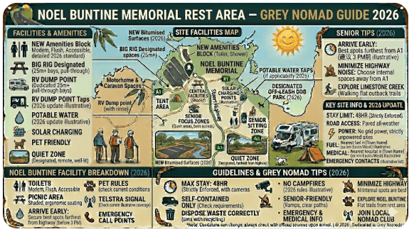
The Noel Buntine Memorial Rest Area is a designated NSW Roads and Maritime Services (Transport for NSW) rest area. As with all rest areas on NSW state highways, the following rules apply:
- Maximum stay: 20 hours within any 24-hour period
- No long-term camping or permanent occupation
- No campfires
- Self-contained vehicles recommended (no dump point on site)
- No booking required — first come, first served
- Free of charge
For seniors on a budget, this free stop is genuinely valuable. Staying one night here versus pulling into a caravan park in Walgett or Gilgandra can realistically save you $30 to $50 — not insignificant over a long trip. However, you will need to be fully self-contained: carry your own water, manage your own waste, and be prepared for no power, no toilets confirmed on-site (see facilities section), and no amenities block.
3. Quick Facts and Key Details 2026
| Detail | Information |
|---|---|
| Rest Area Name | Noel Buntine Memorial Rest Area |
| Highway | Castlereagh Highway, NSW |
| State | New South Wales, Australia |
| Postcode Region | Approx. NSW 2832–2839 corridor |
| Approximate GPS | -30.2500, 147.9500 (verify via Google Maps prior to travel) |
| Nearest Town North | Walgett (~90–100 km north) |
| Nearest Town South | Gilgandra (~90–110 km south) |
| Road Surface | Sealed (Castlereagh Highway is bitumen throughout) |
| Cost | Free |
| Maximum Stay | 20 hours (NSW rest area rule) |
| Toilets | Pit/drop toilet may be present — verify on arrival |
| Dump Point | Not on site — nearest in Gilgandra or Walgett |
| Power | No |
| Water | No potable water on site |
| Mobile Signal | Very limited — Telstra only patchy coverage |
| Suitable For | Caravans, motorhomes, campervans, trucks, heavy vehicles |
| Booking Required | No |
| Managed By | Transport for NSW |
Northern Territory Rest Area Network
If you’re travelling through the Northern Territory, these rest areas form part of a reliable network of free and low-cost stops across major outback highways. From the Stuart Highway to the Barkly and Victoria Highway routes, these locations are popular with caravanners, road trippers, and long-haul drivers.
- Attack Creek Rest Area on the Stuart Highway
- 41 Mile Bore Rest Area along the Barkly Highway
- Bonney Well Rest Stop in the NT outback
- Newcastle Waters Rest Area free camping stop
- King Rest Area suitable for caravans and trucks
- Limestone Creek Rest Area overnight stop
- King West Rest Area highway break stop
- Noel Buntine Memorial Rest Area scenic stop
- Sullivan Campground Rest Area camping area
- East Baines Rest Area on the Victoria Highway
- Beef Road Monument Rest Area tourist stop
- Avon Downs Rest Area on the Barkly Tablelands
- Frewena Rest Stop on the Stuart Highway
- Wonarah Bore Rest Area free camp
- Soudan Bore Rest Area roadside camping
4. How to Get There + GPS Coordinates
📍 GPS Coordinates — Noel Buntine Memorial Rest Area
Approx. -30.2500, 147.9500
Source: Publicly available mapping data. Always verify coordinates using Google Maps or your GPS device before departure. Coordinates may vary slightly depending on the exact pull-off point on the highway.
Enter into your GPS as: Castlereagh Highway, between Gilgandra and Walgett, NSW
Driving Directions — From the South (Gilgandra)
From Gilgandra, head north on the Castlereagh Highway. The highway is sealed and in reasonable condition for this stretch. After travelling approximately 90–110 kilometres north, watch for rest area signage on the left (westbound) side of the highway. The signage is standard brown NSW rest area designation. Entry is a straightforward pull-off — no sharp turn is required.
Driving Directions — From the North (Walgett)
From Walgett, head south on the Castlereagh Highway. Travel approximately 90–100 kilometres south until you see rest area signage on the right (eastbound) side. The pull-off is level and accessible without tight manoeuvring.
Vehicle Suitability
- ✅ Caravans (all sizes) — suitable
- ✅ Motorhomes and campervans — suitable
- ✅ Heavy vehicles and trucks — suitable (shared rest area)
- ✅ 2WD vehicles — suitable (sealed highway access)
- ⚠️ Very large outfits (over 25m combined) — allow extra time to position
5. Road Conditions, Flooding and Sealed vs Unsealed
Is the Road to This Rest Area Sealed?
Yes. The Castlereagh Highway along its full length between Gilgandra and Walgett is a sealed bitumen road. There are no unsealed sections required to reach the Noel Buntine Memorial Rest Area. This is one of its key advantages over more remote rest areas accessed via dirt roads — it is accessible to all vehicle types regardless of the weather, provided the road surface itself is not flood-affected.
Does the Road Flood?
This is a critical question for anyone travelling outback NSW. The Castlereagh Highway crosses the Castlereagh River system and its tributaries. After significant rainfall events — particularly during La Niña years and summer storm seasons — sections of the highway between Gilgandra and Walgett can and do flood. These flood events can close the highway for hours or days.
How to Check Road Conditions Before You Travel
- Live Traffic NSW: livetraffic.com — official highway closures and incidents
- Bureau of Meteorology: bom.gov.au — rainfall forecasts and river heights
- Local knowledge: Ask at the servo in Gilgandra or Walgett — roadhouse operators always know current conditions
- NSW SES: Call 132 500 for flood information
Road Surface Condition
The Castlereagh Highway through this stretch is regularly maintained but is a rural highway — expect occasional rough patches, sections of road edge cracking, and wildlife on the road at dawn and dusk. The road is mostly flat with long straight sections typical of outback NSW plains country. Speed limits are generally 100–110 km/h.
6. Heat and Remoteness — Senior Safety
This rest area sits on the outback plains of north-western NSW. Summer heat is not to be underestimated. Temperatures regularly exceed 38–45°C in December, January and February. There is minimal shade at the rest area itself — the flat plains landscape offers little natural shelter from the sun.
Remoteness Factor
This is genuinely remote country. The nearest town in either direction is 90–110 kilometres away. If you break down, have a medical episode, or run out of fuel or water at this location:
- Mobile phone signal is unreliable to non-existent (Telstra only, very patchy)
- Help is not guaranteed to pass within hours
- You are responsible for your own safety
Tell a responsible person your planned route and expected arrival times before departing Gilgandra or Walgett. If you don’t check in, they should know to contact police. This is standard outback travel practice and especially important for solo senior travellers.
7. Wildlife — Birds, Reptiles and What to Watch For
The outback plains around the Castlereagh Highway corridor are rich in wildlife — sometimes inconveniently so for travellers. Here is what to expect:
Common Wildlife in the Area
- 🦅 Wedge-tailed Eagles — frequently seen perched on road kills or soaring above the highway. Do not swerve for them — they are large and slow to lift off but will move.
- 🦘 Eastern Grey and Red Kangaroos — extremely common at dawn, dusk and throughout the night. This is one of the highest-risk zones for kangaroo strikes in NSW.
- 🐍 Eastern Brown Snake and other venomous species — common across outback NSW. Always check under and around your vehicle before moving it, and watch where you step at night.
- 🐸 Frogs after rain — in large numbers following wet weather events, particularly on the road surface at night.
- 🦎 Blue-tongue lizards and goannas — occasionally seen basking on the road surface in morning sun.
- 🦜 Parrots and budgerigars — flocks of wild budgerigars in particular are spectacular in this region when conditions are right.
8. What Other Websites Don’t Tell You
Most generic rest area listings will give you a name, a pin on a map, and a checkbox list of facilities. Here is what the standard listings miss about the Noel Buntine Memorial Rest Area:
- Trucks stop here too. This is a shared rest area on a major freight corridor. Heavy vehicles will pull in throughout the night. Light sleepers should carry earplugs or park away from the main truck pull-in area if space permits.
- No confirmed toilet on-site in all conditions. Pit toilets at remote rest areas are maintained by Transport for NSW, but their condition varies. Carry a portable toilet or cassette toilet as standard practice.
- The heat radiates off the bitumen at night. Even after sunset, the sealed surface holds heat in summer. Ground-level ventilation around your van will be minimal in still, hot conditions. A 12V fan or rooftop vent is essential.
- Stars are extraordinary. With zero light pollution, this area of outback NSW has some of the best night sky visibility in Australia. On a clear night, the Milky Way is visible with the naked eye. Senior nomads who enjoy astronomy often plan stops here specifically for this reason.
- Flies. In spring and summer, the fly pressure in outback NSW is intense. Carry a fly net for your hat, fly spray, and don’t leave your van door open. It sounds minor — after five minutes outside in December, it doesn’t.
- There is no shade structure. If you rely on sitting outside in the shade, this is not the stop for you in summer. Bring your own awning and use it.
9. Best Time to Visit — Month-by-Month Breakdown
| Month | Temperature Range | Conditions | Recommendation |
|---|---|---|---|
| January | 20–43°C | Extreme heat, storm risk, flies | ⚠️ Avoid if possible |
| February | 19–41°C | Extreme heat, possible flooding | ⚠️ Avoid if possible |
| March | 16–36°C | Cooling, storm risk reducing | ✅ Acceptable with care |
| April | 11–28°C | Pleasant, mild days, cool nights | ✅ Excellent |
| May | 7–22°C | Comfortable, cool mornings | ✅ Excellent |
| June | 3–17°C | Cold nights, clear days | ✅ Good — layer up |
| July | 2–16°C | Cold nights, frost possible | ✅ Good — warm bedding essential |
| August | 4–19°C | Warming, clear and dry | ✅ Very Good |
| September | 7–24°C | Wildflower season, pleasant | ✅ Excellent — peak season |
| October | 11–30°C | Warming up, still pleasant | ✅ Good |
| November | 14–35°C | Heat building, flies increasing | ⚠️ Caution — prepare for heat |
| December | 17–40°C | Extreme heat, fly season peak | ⚠️ Avoid if possible |
10. Free and Low-Cost Camping Alternatives Nearby
If the Noel Buntine Memorial Rest Area is full — or if you need more facilities — here are the realistic alternatives along this corridor:
- Walgett Showground — approximately 90–100 km north. Showground camping available, basic facilities, small donation or nightly fee. Toilets and showers typically available during open periods.
- Gilgandra Showground — approximately 90–110 km south. Another classic grey nomad showground stop. Facilities include toilets, showers and powered sites at low cost. Check with Gilgandra Shire Council for current availability.
- Coonamble — approximately 80 km south-west via Coonamble Road. Small outback town with showground and caravan park options.
- Narran Lake Nature Reserve — to the north-east of Walgett. A remote but spectacular free camping option if you have 4WD access and are seeking wilderness camping. Not suitable for large rigs.
- Lightning Ridge — approximately 70 km north-east of Walgett via the Castlereagh Highway and Cumborah Road. The famous opal mining town has multiple caravan parks and free camp areas — a natural end destination for this highway journey.
11. Dump Points Near the Noel Buntine Memorial Rest Area
There is no dump point at the Noel Buntine Memorial Rest Area itself. This is standard for remote highway rest areas. Plan your waste management around the nearest townships:
| Location | Direction | Approximate Distance | Notes |
|---|---|---|---|
| Walgett | North | ~90–100 km | Caravan park or council dump point — verify locally |
| Gilgandra | South | ~90–110 km | Dump point available — confirm with Gilgandra Shire Council |
| Coonamble | South-West | ~80 km | Check CamperMate for current availability |
To find the most current dump point information, use CamperMate.com.au — it is the most reliably updated Australian dump point database and is free to use.
12. Free Water Sources Near the Castlereagh Highway
There is no potable water available at the Noel Buntine Memorial Rest Area. This is critical planning information for outback travel. Water sourcing in this corridor requires forward planning:
- Walgett — town water available. Fill tanks at the caravan park, dump point, or town tap if accessible.
- Gilgandra — town water available. Fill up before heading north.
- Coonamble — town water available.
13. Fuel Stops Along the Castlereagh Highway
Fuel planning is non-negotiable on this stretch of highway. The Castlereagh Highway between Gilgandra and Walgett is essentially a 200-kilometre fuel gap with minimal intermediate services. Do not assume you can top up mid-route.
| Town / Fuel Stop | Direction from Rest Area | Approximate Distance | Fuel Type Available | Notes |
|---|---|---|---|---|
| Gilgandra | South | ~90–110 km | Unleaded, Diesel, LPG | Multiple servo options. Fill up here before heading north. |
| Coonamble | South-West (via detour) | ~80 km | Unleaded, Diesel | Requires detour off Castlereagh Hwy — confirm hours |
| Walgett | North | ~90–100 km | Unleaded, Diesel | Last major fuel before Lightning Ridge (70 km east) |
| Lightning Ridge | North-East (via Walgett) | ~160 km from rest area | Unleaded, Diesel | Fuel available in town — check prices, often higher than metro |
| Bourke | North-West (via Walgett) | ~220+ km | Unleaded, Diesel | Long detour — fuel plan carefully if heading to Bourke |
Check current fuel prices before departure using PetrolSpy.com.au. Outback fuel prices are consistently higher than metropolitan prices — expect to pay $0.20–$0.40 more per litre than major city prices.
14. Caravan Parks — Paid Alternatives
If you prefer powered sites, showers, a dump point and the security of a managed park, these are the realistic options on either side of the Noel Buntine Memorial Rest Area:
Walgett (North — ~90–100 km)
Walgett has a caravan park offering powered sites and basic facilities. It is a small outback town with a pub, supermarket, fuel and limited services. The caravan park provides access to toilets, showers and a dump point. Walgett is also the gateway to Lightning Ridge, making it a logical staging point.
Gilgandra (South — ~90–110 km)
Gilgandra is a well-serviced outback town on the Castlereagh Highway with a caravan park, showground camping, supermarket, fuel, dump point and public amenities. It is a more comfortable base than Walgett for extended stays and is popular with grey nomads heading north or south on the highway.
Lightning Ridge (via Walgett — ~160 km from rest area)
Lightning Ridge is one of Australia’s most famous outback destinations and has multiple caravan parks ranging from basic to well-equipped. If you are heading to Lightning Ridge, you will find far better facilities there and the famous artesian hot spring baths — a highlight for senior travellers.
Free campsites and rest areas fill fast during school holidays and peak grey nomad season. If your preferred stop is taken, search remaining accommodation options in Walgett, Gilgandra or Lightning Ridge below.
Accommodation search powered by Expedia. Booking through this search supports this website at no extra cost to you. As an affiliate, I earn from qualifying purchases.
15. Full Facilities Comparison Table
| Facility | Noel Buntine Rest Area | Walgett Caravan Park | Gilgandra Caravan Park | Lightning Ridge Parks |
|---|---|---|---|---|
| Cost per night | Free | ~$25–$35 | ~$25–$40 | ~$30–$50+ |
| Power | No | Yes | Yes | Yes |
| Toilets | Pit toilet (variable) | Yes | Yes | Yes |
| Showers | No | Yes | Yes | Yes |
| Dump Point | No | Yes | Yes | Yes |
| Potable Water | No | Yes | Yes | Yes |
| Wi-Fi | No | Limited/No | Limited | Some parks — limited |
| Mobile Signal | Very limited (Telstra only) | Telstra limited | Better — Telstra/Optus | Reasonable Telstra coverage |
| Shade | Minimal to none | Some trees | Some trees | Variable |
| Big Rig Suitable | Yes | Check with park | Yes | Most parks — yes |
| Booking Required | No | Recommended peak | Recommended peak | Yes — peak season |
| Maximum Stay | 20 hours | Flexible | Flexible | Flexible |
| Artesian Baths Access | No | No | No | Yes — Lightning Ridge |
16. Rates — All Options Nearby 2026
| Option | Type | Estimated 2026 Rate | Notes |
|---|---|---|---|
| Noel Buntine Memorial Rest Area | Free overnight (20hr max) | $0 | No facilities. Self-contained only. |
| Walgett Showground | Showground camping | ~$10–$20/night | Basic. Donation basis or small fee. Verify locally. |
| Walgett Caravan Park | Powered sites | ~$30–$40/night | Verify current rates directly with park. |
| Gilgandra Showground | Showground camping | ~$10–$15/night | Good base, basic facilities. Confirm with council. |
| Gilgandra Caravan Park | Powered sites | ~$30–$45/night | Better facilities. Verify current rates. |
| Lightning Ridge Caravan Parks | Powered/unpowered sites | ~$30–$55/night | Multiple parks. Book ahead in peak season (May–Aug). |
17. Senior Safety Checklist — On and Off the Road
✅ Before You Leave Your Last Town
Use this checklist every time you depart for a remote rest area stop. It is not a printable — use it as a mental walkthrough each time you hit the road in outback NSW.
- Fuel tank full — confirmed range exceeds next fuel stop distance by comfortable margin
- Water tanks full — minimum 20L extra per person above tank
- Food supplies adequate for 3+ days beyond planned stop
- PLB or satellite communicator charged and accessible
- Offline maps downloaded to phone or GPS device loaded
- Responsible person notified of your route and expected arrival times
- Road conditions checked via livetraffic.com before departure
- Weather checked via bom.gov.au — rain and temperature forecast
- Medications checked and accessible — not packed in hard-to-reach storage
- Vehicle checked — tyres, lights, tow coupling, van handbrake
- First aid kit stocked and within reach in vehicle cabin
- Fire extinguisher checked and accessible
- Portable toilet cassette emptied at last dump point
- Fly net, sunscreen and hat packed for outdoor use
- Bull bar and driving lights confirmed working before dusk/dawn driving
- Emergency contact numbers written down — not just stored in phone (phones die)
18. What to Do Near the Rest Area — Senior Activity Guide
The Noel Buntine Memorial Rest Area sits in the middle of open outback plains — it is not a destination in itself, but it sits between several genuinely remarkable places worth visiting as part of your Castlereagh Highway journey.
⚡ Lightning Ridge — Opals, Hot Springs and Outback Culture (70 km east of Walgett)
Australia’s famous opal mining capital is one of the great outback experiences for senior travellers. Activities include:
- Walk-in opal mine tours (accessible, many on flat ground)
- The artesian hot spring baths — free of charge, open to all, famous for joint and muscle relief
- Lightning Ridge Outback Art Gallery
- Opal buying from miners direct
- The Door of No Return — famous lightning ridge folk art installation
🌊 Macquarie Marshes Nature Reserve (south — via Coonamble)
One of Australia’s most significant inland wetland systems. During wet years, birdwatching here is extraordinary — tens of thousands of waterbirds including herons, ibis, egrets and spoonbills nest here. Check conditions before visiting — access tracks can be impassable after rain.
🌿 Gilgandra — Wildflower Season (Spring)
Gilgandra and the surrounding plains erupt in wildflowers during September and October following good winter rains. The Castlereagh Highway corridor is lined with native wildflowers, making this one of the most scenic drives in outback NSW during spring.
🌙 Stargazing
The outback plains around the Castlereagh Highway offer exceptional dark sky conditions. Zero light pollution combined with clear, dry air makes for outstanding stargazing. Many grey nomads specifically choose remote rest area stays in this region for the night sky experience. Download the SkySafari or Stellarium app on your phone for constellation identification.
19. 🗺️ Vanlife Savings Spots — GPS Coordinates and Postcodes
Use the interactive Vanlife Savings Spots map below to save this rest area and every stop along your Castlereagh Highway journey. Add your own pins, track your savings versus paid sites, and build your personal outback route — all in one tool designed specifically for grey nomads and vanlifers.
| Stop Name | Type | GPS (Approx.) | Postcode | Notes |
|---|---|---|---|---|
| Noel Buntine Memorial Rest Area | Free rest area | -30.2500, 147.9500 | NSW 2832 | 20hr max. No facilities. Sealed access. |
| Gilgandra (South anchor) | Town — fuel, water, dump | -31.7128, 148.6578 | NSW 2827 | Fill tanks and dump here before heading north |
| Walgett (North anchor) | Town — fuel, water, dump | -30.0347, 148.1133 | NSW 2832 | Last services before Lightning Ridge eastbound |
| Lightning Ridge | Destination — multiple parks | -29.4261, 147.9778 | NSW 2834 | Artesian baths, opal mines, caravan parks |
| Coonamble | Town — fuel, water, showground | -30.9542, 148.3793 | NSW 2829 | Detour option south-west of Castlereagh Hwy |
COPY PROMPT ➔ ASK AI ➔ SAVE TO FORM ➔ ADD SPOT PIN ➔ GET DIRECTIONS
📍 Interactive map — find free camps, rest areas and overnight stops. Enable location for best results.
20. Phone Signal and Emergency Communications
Mobile phone coverage along the Castlereagh Highway between Gilgandra and Walgett is one of the most important safety considerations for this journey. Do not assume you will have signal at or near the rest area.
| Network | Coverage at Rest Area | Notes |
|---|---|---|
| Telstra | Patchy — 0–1 bar possible | Best available option in remote NSW. Not reliable. |
| Optus | Unlikely / No coverage | Optus rural coverage does not extend consistently to this area |
| Vodafone | No coverage | Not available in remote outback NSW |
| Starlink (Satellite) | Full coverage | If you carry a Starlink unit — will work. Setup time required. |
| PLB / EPIRB | Always works | Satellite-based. Register with AMSA. Must-carry for outback travel. |
| HF Radio | Always works | RFDS (Flying Doctor) network. Some grey nomads carry HF radio units. |
Emergency Numbers — Save These Before You Leave Mobile Coverage
- 000 — Emergency services (police, ambulance, fire)
- 132 500 — NSW SES (flood, storm emergencies)
- RFDS (Flying Doctor) — contact via PLB activation or HF radio
- AMSA (Maritime Safety — PLB registration): beacons.amsa.gov.au
21. Campfires, Cooking and Food Purchases Nearby
Campfires at the Noel Buntine Memorial Rest Area
No campfires are permitted at NSW highway rest areas. This is a blanket rule across all Transport for NSW managed rest areas. Do not light fires on or near the rest area — the risk of grass fire in outback NSW is significant, and penalties for illegal fires are substantial.
Cooking at the Rest Area
Cooking in your van kitchen or with a portable gas stove is fine. Use a gas stove with a windshield — the outback plains are frequently windy and open flames can be difficult to manage. Carry a fire blanket as standard safety equipment.
Food and Supplies — Where to Purchase
| Town | Direction | Distance | Supermarket / Food Options |
|---|---|---|---|
| Gilgandra | South | ~90–110 km | IGA or similar, bakery, pub meals, roadhouse |
| Walgett | North | ~90–100 km | Small supermarket, pub, roadhouse food |
| Lightning Ridge | North-East (via Walgett) | ~160 km | Supermarket, bakery, cafes, pub meals |
| Coonamble | South-West | ~80 km | Small supermarket, bakery, pub meals |
22. Pets at the Noel Buntine Memorial Rest Area
Pets are permitted at NSW highway rest areas, but outback travel with pets requires careful planning in this region:
- ✅ Dogs and cats permitted at rest areas — keep on leash at all times
- ⚠️ Extreme heat risk for pets — never leave animals in a closed vehicle in summer. Even in autumn, temperatures inside a parked vehicle can reach lethal levels within minutes.
- ⚠️ Snake awareness — eastern brown snakes and other venomous species are common in this region. Walk dogs on a short lead and check the ground carefully before letting them sniff around the rest area.
- ⚠️ Dingoes and feral animals — while dingo sightings are more common further west, feral dogs and foxes can pose a risk to small pets in outback areas.
- ✅ Carry adequate water for your pet — double your normal allowance in hot weather
- ✅ Carry your pet’s veterinary records — nearest vet may be in Gilgandra, Narromine or Dubbo
23. Accessibility for Seniors with Mobility Limitations
The Noel Buntine Memorial Rest Area is a highway rest area on a sealed surface. Basic accessibility considerations:
- ✅ Flat, sealed or compacted surface — generally accessible for walkers and rollators in dry conditions
- ✅ No steps or kerbs to navigate on the flat pull-off area
- ⚠️ No designated accessible toilet facility confirmed on-site
- ⚠️ Surface may become soft or uneven in wet weather at the edges
- ⚠️ No shade structure — walkers and those who need to be outdoors for any time should carry sun protection
- ⚠️ Ground-level clearance around the van for walker/rollator use — check your own setup
24. Permits, Fees, Etiquette and Waste Management
Permits and Fees
No permit or booking is required for the Noel Buntine Memorial Rest Area. It is a free, open access rest area managed by Transport for NSW. There are no fees.
Etiquette — Leave No Trace
- Pack out all rubbish — there may be no bins on site, or bins may be full
- Do not pour grey water or black water waste on the ground
- Do not idle your generator for extended periods — respect other travellers
- Keep music and noise to a minimum, especially after 9pm and before 7am
- Leave the rest area exactly as you found it — if it was clean, leave it clean
- Do not block access for heavy vehicles — share the space
Waste Management
Carry your own rubbish bags and dispose of waste at the next town. Do not assume bins are available or emptied regularly at remote rest areas. Some rest area bins are only serviced weekly in remote locations. Overflowing bins attract wildlife and pests and create problems for other travellers.
25. Emergency Scenarios — What to Do
Scenario 1: Medical Emergency at the Rest Area
- Activate your PLB immediately if life-threatening
- Try 000 on Telstra mobile — signal may allow a connection even on 1 bar
- Use Garmin inReach or SPOT to send SOS message with GPS coordinates
- Flag down the next passing vehicle — the Castlereagh Highway has regular truck traffic
- The nearest hospital is in Gilgandra (south) or Walgett (north) — both are significant distances away
Scenario 2: Vehicle Breakdown
- Pull completely off the road — maximise your distance from the highway edge
- Hazard lights on immediately
- Place triangles or flares behind your vehicle (carry these as standard)
- Contact your roadside assistance (NRMA, RAA, RACQ, etc.) by satellite communicator if no mobile signal
- Do not walk along the highway — stay with your vehicle
- Nearest tow service is likely in Gilgandra or Walgett — wait times can be 3–6+ hours
Scenario 3: Highway Flooded — You Are Stranded at the Rest Area
- Do not drive into floodwater — turn back or stay at the rest area
- Check livetraffic.com for road closure updates (use satellite internet if available)
- You may need to wait 24–72 hours for water to recede
- If you have adequate water and food supplies, you can wait safely
- Contact emergency services via PLB only if there is immediate risk to life — being stuck is not an emergency in itself
26. Packing List for This Section of Highway
- Minimum 30L drinking water per person (above tank water)
- Food for 5 days beyond planned trip duration
- Full fuel tank + 10–20L jerry can backup
- PLB or satellite communicator — charged and accessible
- Offline maps downloaded to phone and GPS device
- 12V fan or roof vent for hot weather sleeping
- Fly net hat and fly spray
- Bull bar and driving lights operational
- Full first aid kit including snake bite bandages (pressure immobilisation method)
- Roadside triangle warning signs or flares
- Portable toilet with full spare cassette capacity
- Rubbish bags (take all waste with you)
- Fire blanket (for cooking and vehicle fire)
- Jump start pack or jumper cables
- Tyre repair kit and 12V compressor
- Heavy-duty sunscreen SPF50+ and wide-brim hat
- Insect repellent (DEET-based for outback conditions)
- Warm bedding and jacket (cold nights June–August)
- Paper maps as backup to electronic navigation
- Emergency contact list written on paper — not just stored in phone
27. Five Rest Areas Near the Castlereagh Highway Corridor
| Rest Area Name | Highway | Direction | Approx. Distance | Key Notes |
|---|---|---|---|---|
| Noel Buntine Memorial Rest Area | Castlereagh Hwy | — | This location | Free, 20hr max, remote, sealed access |
| Gilgandra Rest Area | Castlereagh Hwy (South) | South | ~90–110 km | Closer to town services. Check for additional facilities. |
| Walgett Rest Area | Castlereagh Hwy (North) | North | ~90–100 km | Near Walgett township. Truck stop shared. |
| Coonamble Rest Area | Castlereagh Hwy junction area | South-West | ~80 km (via detour) | Off-highway. Verify via WikiCamps before planning stop. |
| Narran Lake Rest Area / Access | North of Walgett | North-East | ~120+ km | Remote. 4WD recommended. Outstanding birdwatching in wet season. |
For the most up-to-date rest area locations and current user reviews along this highway, check:
- WikiCamps Australia — grey nomad community reviews
- CamperMate.com.au — rest areas, dump points and camp sites
Travelling from the USA? RV LIFE Trip Wizard is a USA-based RV trip planning tool
RV LIFE Trip Wizard is designed specifically for the North American RV market and is not applicable for Australian travel planning. However, if you are a US-based visitor researching Australian outback travel, it remains an excellent trip planning resource for your US road trips.

As an affiliate, I earn from qualifying purchases at no extra cost to you.
28. Reviews — What Grey Nomads Say About This Stop
“Stayed here overnight in May heading north to Lightning Ridge. Quiet, flat, no drama. A truck or two came through about 2am but nothing that woke us fully. The stars were absolutely stunning — hadn’t seen the Milky Way like that in years. Would definitely stop again.”
“Fine for what it is — a highway rest stop. The toilet was functional but not flash. No shade which was uncomfortable for our dog. Make sure you have everything you need before you stop — there is nothing between Gilgandra and Walgett. Filled up in Gilgandra and still had fuel to spare arriving in Walgett the next morning.”
“Travelling in August — perfect conditions. Cool nights, clear days. Saw a flock of budgies come through in the morning — hundreds of them. This is exactly why we travel. Outback rest areas like this one are a privilege. Treat them well and they’ll still be here for the next generation.”
“Stopped here in November — won’t do that again in a hurry. Flies were absolutely relentless. The heat at 2pm was brutal even with the van shaded. If you’re going through in summer, leave Gilgandra very early and get to Walgett by lunchtime rather than stopping here. Winter and spring are the go.”
29. Frequently Asked Questions
Is the Noel Buntine Memorial Rest Area free to stay at overnight?
Yes. It is a free NSW highway rest area. There are no fees and no booking required. The maximum stay is 20 hours under NSW rest area regulations.
Is the Castlereagh Highway sealed all the way between Gilgandra and Walgett?
Yes. The Castlereagh Highway is a sealed bitumen road for its full length through this corridor. No 4WD is required to reach the rest area. All vehicle types can access it in dry conditions.
Does the Castlereagh Highway flood?
Yes. Sections of the Castlereagh Highway between Gilgandra and Walgett can flood after significant rainfall events. Always check livetraffic.com before departure and do not drive through floodwater.
Is there a toilet at the Noel Buntine Memorial Rest Area?
A pit toilet may be present — these are maintained by Transport for NSW but condition varies. Always carry a portable toilet as backup when travelling remote NSW highways.
How far is it to the nearest fuel from the rest area?
Approximately 90–110 km south to Gilgandra, and approximately 90–100 km north to Walgett. Do not rely on finding fuel between these points.
Is there mobile phone signal at the rest area?
Signal is very limited to non-existent. Telstra may provide a patchy signal — Optus and Vodafone do not reliably cover this area. Carry a PLB or satellite communicator as your primary emergency communication device.
Can large caravans and motorhomes use this rest area?
Yes. The Castlereagh Highway is a major freight and touring route. The rest area is designed to accommodate heavy vehicles and large rigs. Allow extra time to position large outfits in the available space.
Are campfires allowed?
No. Campfires are not permitted at any NSW highway rest area. Use a gas stove for cooking.
What is the nearest town to the Noel Buntine Memorial Rest Area?
Walgett is approximately 90–100 km north, and Gilgandra is approximately 90–110 km south. There are no towns or services at or immediately near the rest area.
Is the rest area suitable for solo senior travellers?
It is suitable with the right preparation. Carry a PLB, have a trip plan lodged with a responsible person, travel with adequate water and food reserves, and be Telstra-networked if relying on mobile. It is a remote location and self-sufficiency is essential.
30. Quick-Reference Card
📍 Noel Buntine Memorial Rest Area — Quick Reference 2026
| Highway | Castlereagh Highway, NSW |
| GPS (Approx.) | -30.2500, 147.9500 — verify before travel |
| Direction | Between Gilgandra (south) and Walgett (north) |
| Cost | Free |
| Max Stay | 20 hours (NSW rest area rule) |
| Road Surface | Sealed bitumen — all vehicles in dry conditions |
| Flood Risk | Yes — check livetraffic.com before travel |
| Toilets | Pit toilet may be present — carry backup |
| Water | No potable water on site |
| Power | No |
| Dump Point | No — nearest Gilgandra or Walgett |
| Mobile Signal | Very limited — Telstra only, patchy |
| Best Season | April – September |
| Nearest Fuel South | Gilgandra — ~90–110 km |
| Nearest Fuel North | Walgett — ~90–100 km |
| Emergency | PLB/satellite — 000 when signal available |
| Road Conditions | livetraffic.com |
| Weather | bom.gov.au |
| Fuel Prices | petrolspy.com.au |
Exclusive Offer: Get 5% OFF all StarterStopper immobiliser products with promo code: RTV5
Visit StarterStopper.com to see our data-backed security solutions
As an affiliate, I earn from qualifying purchases at no extra cost to you.
Related Rest Area Guides — Singleton & Hunter Region
Planning your route from Sydney or the Hunter Valley before heading outback? These rest area guides cover the Singleton and Hunter region starting points for your journey:
- Singleton Rest Areas – Free Camping & GPS Guide (2026)
- Singleton Rest Area NSW
- Singleton East Rest Area
- Gungal Rest Area
- Newmans Road Rest Area
Disclaimer
GPS Disclaimer: Coordinates provided are approximate and intended as a guide only. Always cross-reference with current mapping services. The author accepts no responsibility for navigation errors arising from reliance on GPS coordinates in this article.
Safety: Outback travel carries genuine risks. The author accepts no liability for personal injury, vehicle damage, medical incidents or any loss arising from travel to or from the Noel Buntine Memorial Rest Area or any location mentioned in this guide. Always consult qualified medical, mechanical and emergency services professionals for advice specific to your situation.
Affiliate Disclosure: This article contains affiliate links. As an affiliate, I earn from qualifying purchases at no extra cost to you. All recommendations are made in good faith based on genuine utility for grey nomad and vanlife travellers.
© 2026 RetireToVanLife.com — All rights reserved. Written for Senior Grey Nomads. Safe travels. 🚐