Bulahdelah to Forster Free Camping Guide (2026)
Every free camp, rest area and overnight stop between Bulahdelah and Forster on the Mid North Coast NSW — GPS coordinates, road conditions, fuel distances, facilities, flood warnings and grey nomad travel tips for caravans, motorhomes and campervans.
📅 Last reviewed: January 2026 | Mid North Coast NSW | Bulahdelah to Forster Corridor | 3 verified free camps & rest areas
📋 Table of Contents
- Overview: The Bulahdelah to Forster Corridor
- Why This Stretch Is Perfect for Grey Nomads
- Route Options: Pacific Highway vs Scenic Back Roads
- Road Conditions, Flooding & Unsealed Sections
- All Free Camps & Rest Areas at a Glance
- Stop 1 — Bulahdelah Rest Area
- Stop 2 — Wang Wauk Rest Area
- Stop 3 — Billabong Creek Rest Area
- Fuel Station Guide: North, South, East & West
- Distance Table: Key Towns & Fuel Stops
- Facilities Comparison Table
- Public WiFi & Mobile Coverage
- What To Do Near Each Rest Area
- Best Seasons & Weather
- Senior Grey Nomad Tips for This Corridor
- Free Camping Checklist
- Frequently Asked Questions
- Quick Reference Card
Overview: The Bulahdelah to Forster Corridor
The stretch of road between Bulahdelah and Forster-Tuncurry on New South Wales’ Mid North Coast is one of the most rewarding driving corridors for grey nomads, retirees and van-lifers travelling the Pacific Highway or heading coastward toward the Great Lakes region. Covering approximately 58 kilometres depending on your chosen route, this corridor threads through tall eucalypt forests, past the Wang Wauk River, and eventually opens onto the coast near Forster — one of NSW’s most popular lakeside holiday towns.
For travellers heading between Sydney (350 km south) and Port Macquarie (95 km north), this section offers three confirmed free overnight stops — each with its own character, facilities and surroundings. Whether you’re pulling a 22-foot caravan, driving a self-contained campervan or sleeping in a swag in the back of a ute, there is a legitimate free stop here that suits your setup.
This guide covers everything you need to know before you arrive: road types, flood risk, fuel availability, distances between towns, facilities at each stop, mobile coverage, nearby attractions and practical senior travel tips. Nothing is left out.
Why This Stretch Is Perfect for Grey Nomads
The Bulahdelah to Forster corridor sits in a sweet spot that many travellers either fly straight through on the Pacific Highway or divert off at the last minute without a plan. Here’s why it deserves a deliberate overnight stop:
- 🌲 Forest and coastal variety — You transition from tall eucalypt forest around Bulahdelah and Wang Wauk to the coastal lakes and beaches of Forster-Tuncurry, all within 60 km.
- 🐨 Wildlife-rich environment — Koalas are regularly spotted near Bulahdelah, and the Wang Wauk Forest is home to gliders, wallabies and birdlife.
- 🏖️ Proximity to Forster — Forster is a full-service town with supermarkets (Coles and Woolworths), hospitals, mechanics, dump points and stunning beaches — perfect for restocking before or after a night’s free camping.
- 🛣️ Well-maintained routes — The primary access roads are sealed and well-maintained, with predictable freight traffic and known rest stops.
- 💰 Completely free — All three stops in this cluster are free and legal for overnight stays (within NSW 20-hour rest area rules or designated free camp rules).
- 📍 Strategic positioning — These stops break up the long Sydney-to-Port Macquarie haul perfectly, falling roughly in the middle third of the journey.
Route Options: Pacific Highway vs Scenic Back Roads
There are two primary ways to travel this corridor, and your choice will depend on your rig size, towing capacity and how much you value scenic beauty versus convenience.
Option A — Pacific Highway (M1/A1) via Bulahdelah Township
The Pacific Highway (M1) runs through or bypasses Bulahdelah township (the bypass was completed in 2013 and routes heavy vehicles around the town centre). From Bulahdelah, you can take The Lakes Way (B63) — a scenic regional road that heads southeast through Wang Wauk and Coolongolook before connecting to Forster-Tuncurry. This is the recommended route for caravans and motorhomes.
- Total distance: ~58 km from Bulahdelah to Forster via The Lakes Way
- Road type: Sealed bitumen throughout — The Lakes Way is a well-maintained two-lane regional road
- Suitability: All vehicle types including caravans up to 9 m, motorhomes and campervans
- Speed limits: 80–100 km/h along most of The Lakes Way; reduce to 60 km/h through any roadside communities
- Travel time: Approximately 45–55 minutes without stops (allow 1.5 hours with rest stops)
Option B — Alternate Via Karuah and Tea Gardens (Southern Approach)
Travellers coming from Sydney and the Hunter Valley who wish to avoid the Pacific Highway north of Raymond Terrace can take the Myall Lakes tourist route via Tea Gardens, Hawks Nest and Myall Lakes National Park. This route is longer (~30 km extra) but passes through some of NSW’s most beautiful coastal scenery.
- Route: Raymond Terrace → Karuah → Tea Gardens → Hawks Nest → Mungo Brush Campground (National Parks) → Forster
- Road type: Mostly sealed, but the Mungo Brush section through Myall Lakes NP includes a narrow unsealed section (~10 km) that is NOT suitable for large caravans
- Best for: Solo travellers, 4WDs, small campervans and motorbikes
- Note: A National Parks pass is required for Myall Lakes section overnight stays
Option C — Via Pacific Highway Direct (No Detour)
Travellers who simply want to push through can stay on the Pacific Highway (M1) north of Bulahdelah and continue to Taree (~80 km north), bypassing Forster entirely. The rest areas at Wang Wauk and Billabong Creek both sit off The Lakes Way feeder roads, so this option bypasses the free camps in this cluster. If you need a Pacific Highway rest stop north of Bulahdelah, the Coolongolook Rest Area (~22 km north on the Pacific Hwy) is the nearest designated stop.
Road Conditions, Flooding & Unsealed Sections
Understanding road conditions in this corridor is essential, especially for travellers in larger rigs or those passing through during or after heavy rainfall.
Does the Road Flood?
Yes — specific sections of The Lakes Way and feeder roads are flood-prone. The Mid North Coast of NSW receives some of the highest rainfall in the state, and the lowland areas between Bulahdelah and Forster sit close to sea level around the Myall River system, Smiths Lake and Wallis Lake. Here is what you need to know by location:
| Road Section | Flood Risk | Season | Notes |
|---|---|---|---|
| The Lakes Way — Forster end (near Wallis Lake) | 🟡 Moderate | Feb–May | Low-lying sections near Wallis Lake can flood in sustained rain. Check Live Traffic NSW before departure. |
| Wang Wauk Road (feeder to Wang Wauk Rest Area) | 🟡 Moderate | Year-round after heavy rain | The Wang Wauk River can run high after storms. Access road may develop puddles but rarely closes fully. |
| Bulahdelah township entry roads (Pacific Hwy) | 🟢 Low | — | Pacific Highway is generally above flood level through here. Bypass road is elevated. |
| Billabong Creek Road / access to Billabong Creek Rest Area | 🔴 High in wet season | Dec–April | Billabong Creek itself can rise quickly after rain. The access area is low and flat. Do not park here during a rain event or if the creek is flowing fast. |
| Myall Lakes NP — Mungo Brush Rd (unsealed) | 🔴 Very High | Dec–May | Unsealed road closes frequently in wet weather. Road becomes boggy and impassable. Not for caravans at any time. |
Are Any Roads Unsealed?
The primary routes in this cluster (The Lakes Way and Pacific Highway) are fully sealed. However, some access tracks to free camp spots — particularly near Billabong Creek — involve a short unsealed section. Details:
- Bulahdelah Rest Area: Accessed directly from the sealed Pacific Highway. Fully sealed access. ✅
- Wang Wauk Rest Area: Accessed from The Lakes Way (B63), which is sealed. The rest area turning and parking area is sealed compacted gravel — suitable for caravans and motorhomes. ✅
- Billabong Creek Rest Area: Accessed from a short unsealed gravel track (~200 m off The Lakes Way). The gravel is generally firm and passable, but can become soft and rutted after heavy rain. ⚠️ Large caravans should exercise caution and check conditions first.
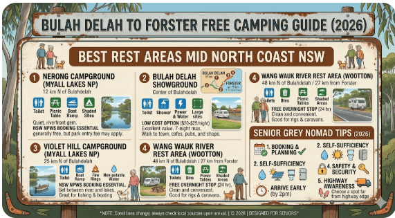
All Free Camps & Rest Areas at a Glance
Here is a single-view summary of all three confirmed free overnight stops in the Bulahdelah–Forster corridor. Use this table for quick planning, then click the individual links for full detail.
| Stop | Name | Location / Road | GPS Coordinates | Toilets | Caravans | Max Stay | Cost |
|---|---|---|---|---|---|---|---|
| 1 | Bulahdelah Rest Area | Pacific Highway, Bulahdelah NSW 2423 | -32.4025, 152.2058 | ✅ Yes | ✅ Yes | 20 hrs | Free |
| 2 | Wang Wauk Rest Area | The Lakes Way, Wang Wauk NSW 2423 | -32.3641, 152.2873 | ✅ Yes | ✅ Yes | 20 hrs | Free |
| 3 | Billabong Creek Rest Area | The Lakes Way, near Tuncurry NSW 2428 | -32.1845, 152.4712 | ⚠️ Basic | ⚠️ Small rigs | 20 hrs | Free |
Stop 1 — Bulahdelah Rest Area
📍 Bulahdelah Rest Area — Quick Facts
Address: Pacific Highway, Bulahdelah NSW 2423
Postcode: 2423
GPS: -32.4025, 152.2058 (source: OpenStreetMap / publicly verified)
Road: Pacific Highway (M1) — fully sealed access
Full Guide: Read the complete Bulahdelah Rest Area guide →
📡 GPS Coordinates — Bulahdelah Rest Area
-32.4025, 152.2058
Copy these coordinates directly into Google Maps, Hema Explorer or WikiCamps.
The Bulahdelah Rest Area sits directly on the Pacific Highway (M1) at the northern edge of Bulahdelah township — one of the most well-known koala habitat areas in NSW. This is a dedicated NSW Roads & Transport rest area, built to the standard highway specification with sealed parking, picnic tables, and flushing toilets. It is the most accessible and well-maintained stop in this cluster.
What’s at the Bulahdelah Rest Area?
- ✅ Flushing toilets (accessible/disabled facility included)
- ✅ Sealed, flat parking bays — suitable for B-doubles and large rigs
- ✅ Picnic tables with shade
- ✅ Dog-friendly (on-lead)
- ✅ 20-hour maximum stay applies (NSW standard)
- ✅ Well-lit at night — overhead lighting
- ❌ No dump point on-site (nearest is in Bulahdelah town — approximately 2 km)
- ❌ No potable water tap (confirm at site — water availability can vary)
- ❌ No power hookup
- ❌ No shower
What’s Nearby — Bulahdelah
- Bulahdelah town centre — 2 km south. Fuel, small supermarket (IGA), bakery, pub meals, pharmacy and dump point.
- Bulahdelah Mountain — The Alum Mountain lookout trail starts 3 km south of town. Short walk (1 km return) with panoramic views over the Myall River valley.
- Myall River boat ramp — 4 km from the rest area. Kayaking, fishing and river swimming in a stunning forest setting.
- Myall Lakes National Park entrance — 18 km southeast via Boggy Creek Road (sealed). Day visits and camping (fee required for NP camping).
- Stringybark Creek picnic area — 8 km northeast on the Pacific Hwy. A popular truck driver and grey nomad picnic spot with large trees.
“We pulled in here after a big day from Sydney — about 5:30 PM and there were still 4 or 5 spots left. Very clean toilets, nice trees around the edges, and the highway noise wasn’t too bad with earplugs. Would definitely use again.”
★★★★☆
— Margaret & Alan, 2025, 20 ft caravan (WikiCamps review summary)
Stop 2 — Wang Wauk Rest Area
📍 Wang Wauk Rest Area — Quick Facts
Address: The Lakes Way, Wang Wauk NSW 2423
Postcode: 2423
GPS: -32.3641, 152.2873 (source: WikiCamps AU / publicly available)
Road: The Lakes Way (B63) — fully sealed access. Compacted gravel parking area.
Full Guide: Read the complete Wang Wauk Rest Area guide →
📡 GPS Coordinates — Wang Wauk Rest Area
-32.3641, 152.2873
Copy these coordinates directly into Google Maps, Hema Explorer or WikiCamps.
The Wang Wauk Rest Area is the most scenically rewarding stop in this cluster — and arguably one of the nicest free rest areas on the entire Mid North Coast. Set beside the Wang Wauk River within the fringe of the Wallingat National Park buffer zone, this stop offers genuine bush camping atmosphere without requiring a National Parks permit. The river is often audible from the camping area, and the surrounding tall forest creates an immediate sense of escape from highway travel.
Wang Wauk is a locality name — not a town — referring to the river and surrounding forested area along The Lakes Way, approximately 18 km southeast of Bulahdelah and 38 km northwest of Forster.
What’s at the Wang Wauk Rest Area?
- ✅ Toilets — pit/composting style (not flushing — confirm current condition before visit)
- ✅ Compacted gravel parking area — suitable for caravans and motorhomes up to 9–10 m (larger rigs should check turning radius on arrival)
- ✅ Picnic tables
- ✅ Shade trees — tall eucalypts provide natural canopy
- ✅ Dog-friendly (on-lead)
- ✅ Riverside/forest atmosphere
- ✅ 20-hour maximum stay
- ⚠️ Toilet condition is variable — carry your own supplies as backup
- ❌ No dump point on-site
- ❌ No potable water
- ❌ No power
- ❌ No phone signal (Telstra partial, Optus/Vodafone limited to none)
Wang Wauk River — Swimming & Fishing
The Wang Wauk River runs through the Wallingat National Park and is a popular spot for freshwater swimming, kayaking and fishing. The river is fed by clean forest catchments and the water is generally clear and cool. Access to the riverbank is available from the rest area. Fish species include bass and bream — check NSW DPI regulations for current size and bag limits before fishing.
What’s Nearby — Wang Wauk
- Wallingat National Park — The rest area sits adjacent to the park buffer. No entry fee for day visits. Walking tracks accessible directly from The Lakes Way.
- Smiths Lake — 12 km southeast. A beautiful coastal lagoon with a small village, boat ramp, and a general store. Good swimming beach on the lake.
- Seal Rocks — 35 km east via Seal Rocks Road (partly unsealed). Remote beach with lighthouse and regular whale watching during migration season (June–November). Not suitable for large caravans.
- Bulahdelah township — 18 km northwest on The Lakes Way. Fuel, food, IGA supermarket, bakery.
- Forster — 38 km southeast on The Lakes Way. Full services, supermarkets, hospital, dump point.
“Absolutely stunning spot. We had the place to ourselves on a Tuesday night in September. The river was just audible from our van — lovely white noise. No phone signal at all, which honestly was half the appeal. A real switch-off camp.”
★★★★★
— Sue & Dave, October 2025, Motorhome (WikiCamps review summary)
Stop 3 — Billabong Creek Rest Area
📍 Billabong Creek Rest Area — Quick Facts
Address: The Lakes Way, near Tuncurry NSW 2428
Postcode: 2428
GPS: -32.1845, 152.4712 (source: WikiCamps AU / publicly available)
Road: The Lakes Way — sealed main road. Short (~200 m) unsealed gravel access track to site.
Full Guide: Read the complete Billabong Creek Rest Area guide →
📡 GPS Coordinates — Billabong Creek Rest Area
-32.1845, 152.4712
Copy these coordinates directly into Google Maps, Hema Explorer or WikiCamps.
The Billabong Creek Rest Area is the northern-most stop in this cluster, sitting closest to Tuncurry and Forster — approximately 8 km west of the Tuncurry bridge on The Lakes Way. This is a more rustic, informal stop compared to Bulahdelah or Wang Wauk, suited to self-contained travellers who don’t need facilities and want a quiet spot close to the Forster services hub.
Billabong Creek itself is a small tidal creek that feeds into the broader Wallis Lake estuary system — one of NSW’s most important estuaries for birdlife and marine ecology. The area around the creek is flat, grassy and shaded by melaleuca (paperbark) trees — a classic coastal lowland landscape.
What’s at the Billabong Creek Rest Area?
- ⚠️ Toilets — basic pit toilet (condition variable; not always maintained)
- ⚠️ Parking area — flat gravel/grass. Suitable for small to medium campervans and caravans. Large rigs (over 8 m) should exercise caution due to turning space and soft ground after rain.
- ✅ Shade — paperbark and coastal scrub provide partial shade
- ✅ Dog-friendly (on-lead)
- ✅ Birdwatching — outstanding wading birds, herons, kingfishers and shorebirds
- ✅ Fishing from creek bank (check current NSW DPI regulations)
- ✅ 20-hour maximum stay
- ❌ No dump point on-site (Forster dump point: 9 km east)
- ❌ No potable water
- ❌ No power
- ⚠️ Flood-prone — do NOT stay here during or immediately after heavy rain
What’s Nearby — Billabong Creek / Tuncurry-Forster
- Forster town centre — 9 km east. Coles, Woolworths, Aldi, hospital, pharmacy, dump point, beaches, restaurants.
- Tuncurry — 9 km east (same bridge as Forster — joined by Tuncurry Bridge over Wallis Lake entrance). Fuel, shops, beach.
- Wallis Lake — The broader lake system starts just east of the rest area. Boating, fishing, oyster farms and scenic lake drives.
- Booti Booti National Park — 15 km southeast via The Lakes Way. Walking tracks, beaches and camping (NP fees apply).
- One Mile Beach, Forster — 12 km east. One of the Mid North Coast’s most beautiful surf beaches, patrolled in season.
- Cape Hawke Lookout — 14 km east. 360° panoramic views over Forster, Tuncurry and the entire Great Lakes coastline. Short steep walk from carpark.
“Great spot if you just need somewhere quiet near Forster without paying caravan park prices. Bit basic — the toilet was not great — but the birdlife around the creek was incredible at dawn. Bring your earplugs if trucks use The Lakes Way at night in your area.”
★★★☆☆
— Peter T., April 2025, Self-contained campervan (WikiCamps review summary)
Fuel Station Guide: North, South, East & West
Fuel planning is critical for grey nomads — especially those towing large caravans where fuel consumption can easily double compared to solo driving. Here is a complete breakdown of every fuel stop within practical range of the three rest areas in this cluster, in every direction.
🔽 South of Bulahdelah (Heading Toward Sydney / Newcastle)
| Town / Station | Distance from Bulahdelah | Road | Fuel Types | Notes |
|---|---|---|---|---|
| Karuah (Ampol / BP) | ~40 km south | Pacific Hwy (M1) | ULP, Diesel, E10 | Highway servo — 24 hours. Good for trucks and caravans. Café attached. |
| Raymond Terrace (multiple) | ~60 km south | Pacific Hwy / New England Hwy | ULP, Diesel, Premium, LPG | Full range of fuel types. Coles Express, Ampol, United. Cheaper than coastal stops. |
| Maitland (multiple) | ~95 km south | New England Hwy / Pacific Hwy | All types including LPG | Best prices in the region. Stock up here if heading north. |
| Bulahdelah township (BP) | 2 km from rest area | Pacific Hwy / town centre | ULP, Diesel, E10 | BP service station in town. Prices slightly above metro but acceptable. Hours: ~7 AM–8 PM. |
🔼 North of Bulahdelah (Heading Toward Port Macquarie / Coffs Harbour)
| Town / Station | Distance from Bulahdelah | Road | Fuel Types | Notes |
|---|---|---|---|---|
| Coolongolook (limited) | ~22 km north | Pacific Hwy (M1) | ULP, Diesel | Small service station — not always open. Do not rely on this as sole fuel source. Check hours before arriving. |
| Taree (multiple — Coles Express, Ampol, United) | ~80 km north | Pacific Hwy (M1) | All types including LPG, AdBlue | Major service town. Fill up here if heading further north. 24-hr options available. Best prices north of Bulahdelah. |
| Port Macquarie (multiple) | ~145 km north | Pacific Hwy (M1) | All types | Major coastal city — full services. Prices can spike in holiday season. |
🔁 East — Forster-Tuncurry (Via The Lakes Way)
| Town / Station | Distance from Bulahdelah | Road | Fuel Types | Notes |
|---|---|---|---|---|
| Smiths Lake (general store) | ~30 km east | The Lakes Way (B63) | ULP only (limited) | General store with basic fuel. Not reliable for diesel. Do not rely on this as primary stop. Limited hours. |
| Tuncurry (BP / United) | ~55 km east | The Lakes Way → Tuncurry Bridge | ULP, Diesel, E10 | Full service station. Near the bridge on the Tuncurry side. Good for topping up before heading north on the Pacific Hwy. |
| Forster (Ampol, Coles Express, Puma) | ~58 km east | The Lakes Way → Forster | ULP, Diesel, E10, Premium, LPG | Multiple options in Forster. Best prices in this eastern arm of the route. Supermarkets also nearby for LPG swap-and-go. |
🔄 West — Inland Options (Via Gloucester / Barrington Tops)
| Town / Station | Distance from Bulahdelah | Road | Fuel Types | Notes |
|---|---|---|---|---|
| Gloucester | ~70 km west via Bucketts Way | Bucketts Way (unsealed sections) | ULP, Diesel | Small rural town with fuel and basic services. Bucketts Way has unsealed sections — not recommended for large caravans. Beautiful scenery. |
| Stroud | ~55 km southwest | Bucketts Way / Clarence Town Road | ULP, Diesel | Small town. Limited hours. Not a viable primary fuel stop for large rigs on this route. |
Distance Table: Key Towns & Points Along the Route
| From → To | Distance | Road | Approx Drive Time | Notes |
|---|---|---|---|---|
| Sydney (CBD) → Bulahdelah | ~285 km | Pacific Hwy (M1) | 3 hrs 10 min | Via M1 motorway. Allow extra time in peak hour or holiday periods. |
| Newcastle → Bulahdelah | ~145 km | Pacific Hwy (M1) | 1 hr 40 min | Good highway all the way. Fuel at Raymond Terrace or Karuah. |
| Bulahdelah → Wang Wauk Rest Area | ~18 km | The Lakes Way (B63) | 15–20 min | Sealed road. Winding in sections — reduce speed with caravan. |
| Wang Wauk → Smiths Lake | ~12 km | The Lakes Way | 10–12 min | Sealed. Small village, general store, swimming beach on lake. |
| Wang Wauk → Billabong Creek Rest Area | ~26 km | The Lakes Way | 22–28 min | Sealed main road. Rest area access track ~200 m unsealed. |
| Billabong Creek Rest Area → Forster | ~9 km | The Lakes Way | 8–10 min | Sealed. Forster has all services including dump point, supermarkets, hospital. |
| Bulahdelah → Forster (full corridor) | ~58 km | The Lakes Way (B63) | 45–55 min | Winding scenic road. Allow extra time with caravan. No overtaking lanes in many sections. |
| Forster → Taree | ~55 km | The Lakes Way / Pacific Hwy via Tuncurry | 45–55 min | Via Tuncurry and Pacific Hwy north. Taree has full services, hospital, all fuel types. |
| Bulahdelah → Port Macquarie | ~145 km | Pacific Hwy (M1) | 1 hr 40 min | Via Pacific Hwy direct. Or longer scenic route via Forster + Tuncurry + Pacific Hwy north. |
| Forster → Port Macquarie | ~115 km | The Lakes Way → Pacific Hwy north | 1 hr 20 min | Via Tuncurry Bridge then Pacific Hwy. Good sealed road throughout. |
Facilities Comparison Table
| Facility | Bulahdelah Rest Area | Wang Wauk Rest Area | Billabong Creek Rest Area |
|---|---|---|---|
| Toilets | ✅ Flushing + accessible | ⚠️ Pit toilet (variable) | ⚠️ Basic pit toilet |
| Potable Water | ❌ Not reliable | ❌ No | ❌ No |
| Dump Point | ❌ (Town: 2 km) | ❌ (Forster: 40 km) | ❌ (Forster: 9 km) |
| Sealed Parking | ✅ Yes | ⚠️ Compacted gravel | ⚠️ Gravel/grass mix |
| Caravan Suitable | ✅ All sizes | ✅ Up to ~10 m | ⚠️ Small–medium only |
| Picnic Tables | ✅ Yes | ✅ Yes | ⚠️ Limited |
| Lighting | ✅ Yes | ❌ No | ❌ No |
| Power Hookup | ❌ No | ❌ No | ❌ No |
| Shower | ❌ No | ❌ No | ❌ No |
| Dogs Allowed | ✅ On-lead | ✅ On-lead | ✅ On-lead |
| Mobile Coverage | ✅ Good (all networks) | ❌ Very limited | ⚠️ Partial (Telstra) |
| Flood Risk | 🟢 Low | 🟡 Moderate | 🔴 High in wet season |
| Highway Noise | ⚠️ Moderate (Pacific Hwy) | ✅ Quiet (forest) | ✅ Quiet (remote) |
| Max Stay | 20 hours | 20 hours | 20 hours |
| Cost | Free | Free | Free |
Public WiFi & Mobile Coverage
Mobile coverage in this corridor ranges from excellent at the highway stops to essentially zero in the Wang Wauk forest area. Here is a realistic breakdown by location:
| Location | Telstra | Optus | Vodafone | Public WiFi | Notes |
|---|---|---|---|---|---|
| Bulahdelah Rest Area | ✅ 4G | ✅ 4G | ⚠️ 3G | ❌ | Good coverage on Pacific Hwy. Bulahdelah township has free WiFi at library. |
| Bulahdelah Township | ✅ 4G | ✅ 4G | ⚠️ 3G–4G | ✅ Library WiFi | Bulahdelah Library (70 Crawford St) — free public WiFi during opening hours. |
| Wang Wauk Rest Area | ⚠️ 1 bar / Edge | ❌ No signal | ❌ No signal | ❌ | Essentially no coverage. Download offline maps before arrival. |
| Smiths Lake Village | ✅ 4G | ⚠️ 3G | ❌ | ❌ | Telstra 4G reliable. Small general store may offer incidental WiFi access. |
| Billabong Creek Rest Area | ⚠️ 3G partial | ❌ | ❌ | ❌ | Telstra partial only. 9 km to Forster for full coverage. |
| Forster-Tuncurry | ✅ 4G/5G | ✅ 4G | ✅ 4G | ✅ Multiple spots | Free public WiFi at Forster Library (Breeze Parade), Forster Beach Caravan Park area (some public zones), and Tuncurry Headland Park. Maccas Forster has free WiFi. |
What To Do Near Each Rest Area
Near Bulahdelah — Top Activities
- 🐨 Koala watching — Walk the bushland fringe around town at dawn/dusk. Koalas are regularly spotted in the trees along Myall Street and Crawford Street.
- 🥾 Alum Mountain Lookout Walk — 3 km south of town. 1 km return walk. Panoramic views over the Myall River floodplain and surrounding forest. Accessible track but includes some steep steps at the top.
- 🎣 Myall River fishing — Flathead, bream and bass. Best fishing: Myall River at the town boat ramp (off Crawford Street).
- 🛶 Kayaking — Hire kayaks from Myall River Adventures (check current operator status 2026) or launch your own from the public ramp.
- 🏛️ Great Lakes Museum — Small but interesting local history museum in the town centre. Check opening hours.
Near Wang Wauk — Top Activities
- 🌊 Wang Wauk River swimming — Fresh, clear forest-fed river. Rope swings reported at some local spots. Always check water levels and current before swimming.
- 🐦 Bird and wildlife watching — Outstanding. Yellow-tailed Black Cockatoos, Gang-Gangs, Azure Kingfishers and Wedge-tailed Eagles all recorded.
- 🥾 Wallingat National Park walking tracks — Several walking tracks accessible from The Lakes Way near Wang Wauk. Check NPWS website for current track conditions.
- 🌅 Sunrise and sunset photography — The river and forest setting provides excellent golden hour photography conditions.
- 🐟 Freshwater fishing — Bass and bream in the Wang Wauk River. NSW Recreational Fishing Licence required (available online from NSW DPI).
Near Billabong Creek / Forster — Top Activities
- 🏄 Forster Main Beach — 9 km east. Patrolled surf beach with excellent swimming and bodyboarding.
- 🐬 Dolphin & whale watching — Dolphin cruises operate from Forster Marina (June–November for humpback whale migration; dolphins year-round).
- ⛵ Wallis Lake boating — Boat ramp at Forster. One of NSW’s largest and most scenic coastal lakes.
- 🦅 Cape Hawke Lookout — 14 km east. 360° views. Short but steep walk (15–20 min). Highly recommended at sunrise.
- 🦀 Oyster farm tours — Wallis Lake is famous for its Sydney Rock Oysters. Several farms offer tours and tastings. Check current operators in 2026.
- 🥾 Booti Booti National Park — 15 km southeast. Walk the Seven Mile Beach coastal track or the Booti Hill walking track with lake and ocean views.
Best Seasons & Weather
The Mid North Coast of NSW has a warm temperate to subtropical climate. Here’s what to expect across the year for the Bulahdelah–Forster corridor:
| Season | Months | Temperature | Rainfall | Suitability | Notes |
|---|---|---|---|---|---|
| Autumn | March–May | 18–26°C | Moderate–High | ⭐⭐⭐⭐ | Excellent temperatures. Still some lingering La Niña rainfall risk in March–April. Crowds reduce after Easter. Best birdwatching season. |
| Winter | June–Aug | 10–20°C | Low | ⭐⭐⭐⭐⭐ | Best season. Dry, clear days. Low crowd numbers. Whale migration offshore (June–October). Cool nights — bring warm bedding. |
| Spring | Sep–Nov | 16–26°C | Low–Moderate | ⭐⭐⭐⭐⭐ | Outstanding. Wildflowers in bloom. Warm days, cool nights. Crowds building toward November. Book ahead for Forster-area accommodation if needed. |
| Summer | Dec–Feb | 22–32°C | High (storms) | ⭐⭐ | Busy, hot and humid. Flood risk highest at Billabong Creek. Rest areas fill early — arrive before 2 PM. School holidays extremely crowded. Thunderstorms frequent December–February. |
Senior Grey Nomad Tips for This Corridor
Here are the most important practical tips for older travellers, seniors, retirees and grey nomads navigating the Bulahdelah–Forster corridor:
Road Safety Tips
- 🚗 Take The Lakes Way slowly — It’s a winding, narrow two-lane road with limited passing opportunities. The speed limit is often 80 km/h but realistically you’ll be comfortable at 70 km/h with a caravan. Never rush this road.
- 🦘 Dawn and dusk wildlife risk is HIGH — Kangaroos, wallabies and wombats are active at dawn and dusk along The Lakes Way and around Bulahdelah. Pull over if visibility drops, and never swerve suddenly. A steady brake is safer than a violent swerve with a caravan attached.
- 🚧 Check road conditions before departure — Always check Live Traffic NSW the morning of travel for any closures or flood events, particularly after overnight rain.
- ⛽ Fuel before you leave Bulahdelah — There is no reliable fuel stop between Bulahdelah and Tuncurry (58 km) on The Lakes Way. Fill up in Bulahdelah.
- 🅿️ Arrive early for rest areas — By 4:00 PM on any Friday night or public holiday, popular rest areas are full. Aim to arrive before 2:00 PM in peak periods.
Health & Comfort Tips
- 💊 Medical services — The nearest hospitals are at Forster (Manning Base Hospital — 25-minute drive from Wang Wauk) and Taree (Manning Base Hospital — ~80 km north of Bulahdelah). Bulahdelah has a medical centre (confirm current operating hours 2026) but no hospital. Keep this in mind for solo travellers or those with health conditions.
- 🚿 Dump point before you go — The Bulahdelah Dump Point (confirm location at town council — near showground area) is the last convenient dump before Wang Wauk. Forster has a council dump point near the caravan park area. Use these before or after your rest area stay.
- 🌡️ Summer heat management — In December–February, midday temperatures can reach 30–35°C. Park in shade if possible, ensure good ventilation in your van, stay hydrated and schedule rest between 12 PM–4 PM.
- 🐝 Insect management — The coastal lowland areas (especially Billabong Creek) can have significant mosquito activity at dawn and dusk, particularly in summer. Carry strong repellent and ensure your van screens are intact.
Rig-Specific Tips
- 🚌 Motorhomes > 7.5 m: Wang Wauk and Billabong Creek may have limited turning radius. Perform a dry check of the parking area layout on arrival before committing to a spot.
- 🚐 Large caravans: Stick to Bulahdelah Rest Area or Wang Wauk. Billabong Creek is not recommended for rigs over 8 m due to access track and turning constraints.
- ⚡ Solar power: All three sites are off-grid. Ensure your solar system and batteries are fully charged before arrival. Wang Wauk has excellent sun exposure in the parking area despite surrounding trees. Billabong Creek has partial shade that may reduce solar output.
Free Camping Checklist — Bulahdelah to Forster
Use this checklist before departing for any of the three rest areas in this cluster:
Before You Leave Home / Last Town
- Check Live Traffic NSW for road closures and flood alerts (livetraffic.com or 132 701)
- Check Bureau of Meteorology forecast for Mid North Coast NSW (bom.gov.au)
- Top up fuel — minimum 3/4 tank before entering The Lakes Way corridor
- Use dump point (Bulahdelah or Taree) before heading east
- Fill fresh water tank fully
- Download offline maps (Google Maps offline, Hema Explorer, WikiCamps) for Wang Wauk area (no phone coverage)
- Charge satellite communicator if carrying one
- Stock 2–3 days of food and water (closest supermarket is Forster)
- LPG — check tank level and carry a spare cylinder if possible
- Medications — ensure you have enough supply (no pharmacy between Bulahdelah and Forster)
- Insect repellent packed and accessible
- Earplugs (Bulahdelah Rest Area has highway noise)
At the Rest Area
- Check the site for condition before committing (especially after rain — Billabong Creek)
- Level the van/motorhome
- Deploy solar panels / check solar is connected
- Set up annex or awning away from traffic side
- Keep dogs on-lead at all times
- Stow food securely — wildlife (possums, crows) active at night
- Do not block toilet access or other campers’ access routes
- Note 20-hour maximum stay — plan departure time accordingly
- Leave no trace — pack out all rubbish (no bins at Wang Wauk or Billabong Creek)
Frequently Asked Questions
Is camping between Bulahdelah and Forster free?
Yes — all three rest areas listed in this guide (Bulahdelah Rest Area, Wang Wauk Rest Area and Billabong Creek Rest Area) are completely free. There is no registration, booking system or payment required. Simply pull in, follow NSW rest area rules (maximum 20-hour stay) and leave the site clean.
How long can I stay at NSW rest areas?
NSW Transport rules set a maximum 20-hour stay at designated rest areas. This is intended for driver fatigue management, not extended holidays. You cannot stay multiple consecutive nights. After 20 hours, you must move on. The 20-hour rule is enforced and fines apply.
Can I take a large caravan on The Lakes Way?
Yes — The Lakes Way (B63) is a sealed two-lane regional road that is suitable for caravans of normal dimensions (up to standard 2.5 m width and up to ~10 m length). However, the road is winding and hilly in sections, with limited overtaking opportunities. Drive to conditions and reduce speed significantly — 70 km/h is a practical safe speed when towing. Very long combinations (>19 m total) should take care at certain bends.
Is there a dump point near Wang Wauk?
No — there is no dump point at Wang Wauk Rest Area. The nearest dump points are in Bulahdelah (approximately 18 km west) and Forster (approximately 40 km east). Always empty your holding tank before arriving at Wang Wauk.
Does The Lakes Way flood?
Sections of The Lakes Way near Wallis Lake and the lower-lying coastal sections can flood during sustained heavy rainfall events. The road is generally above flood level through Wang Wauk but the Billabong Creek area near Tuncurry is at higher risk. Always check Live Traffic NSW before travelling after rain.
What is the nearest hospital to Wang Wauk Rest Area?
The nearest hospital is Manning Base Hospital in Taree, approximately 75–80 km north via Pacific Highway. However, Forster has a medical centre and ED services approximately 38 km east. In a medical emergency, call 000 immediately — helicopter retrieval is the fastest option for serious emergencies in this area.
Is there free WiFi in Forster?
Yes — Forster Library (Breeze Parade, Forster) offers free public WiFi during opening hours. McDonald’s Forster also offers free WiFi with purchase. The broader Forster town centre has strong 4G/5G coverage from all major networks.
Can I take my dog to these rest areas?
Yes — dogs are permitted at all three rest areas on a lead. Ensure you clean up after your dog and do not allow them off-lead, particularly near the Wang Wauk River (freshwater crocodiles are not found this far south in NSW, but snakes and other wildlife present risks). Dogs are not permitted inside Wallingat or Myall Lakes National Parks without special approval.
What fuel is available in Bulahdelah?
The BP service station in Bulahdelah township (approximately 2 km from the Pacific Highway rest area) sells Unleaded (91), E10 and Diesel. Opening hours are approximately 7 AM–8 PM but confirm locally. For premium unleaded or LPG, travel to Taree or Forster/Tuncurry.
Is Wang Wauk Rest Area suitable for self-contained motorhomes?
Yes — Wang Wauk is an excellent stop for self-contained motorhomes. The gravel parking area accommodates motorhomes up to approximately 9–10 m, and the forest and riverside setting is outstanding. Ensure you are fully self-contained (water, waste management, power) as there are no services on-site and no mobile coverage to call for assistance.
Quick Reference Card
📋 Bulahdelah to Forster Free Camping — Quick Reference 2026
| Corridor Length | ~58 km (Bulahdelah to Forster via The Lakes Way) |
| Primary Road | The Lakes Way (B63) — sealed, two-lane regional road |
| Free Stops | 3 confirmed (Bulahdelah RA, Wang Wauk RA, Billabong Creek RA) |
| Max Stay at Each | 20 hours (NSW standard) |
| Cost | Free — all three stops |
| Nearest Fuel (East) | Tuncurry BP/United — 55 km from Bulahdelah |
| Nearest Fuel (West) | Bulahdelah BP — 2 km from Pacific Hwy rest area |
| Nearest Dump Point | Bulahdelah (~2 km) or Forster (~9–40 km depending on stop) |
| Nearest Hospital | Manning Base Hospital, Taree (~80 km) / Forster ED (~38 km from Wang Wauk) |
| Flood Risk Areas | Billabong Creek (high), Wang Wauk area (moderate), Lakes Way near Wallis Lake (moderate) |
| Best Season | Winter / Spring (June–October) |
| Road Condition Check | livetraffic.com or 132 701 |
| Weather Forecast | bom.gov.au — Mid North Coast NSW zone |
| Emergency | 000 (Wang Wauk — no mobile — use satellite device or drive to coverage) |
Recommended Gear for This Corridor
Based on what works best for this specific stretch of the Mid North Coast NSW — particularly for the off-grid Wang Wauk and Billabong Creek stops:
- 🛰️ Garmin inReach Mini 2 — Essential for Wang Wauk (zero phone coverage). Two-way messaging + SOS from anywhere.
- 🦟 Bushmans DEET Insect Repellent (40%) — The only repellent that handles coastal NSW mozzies at Billabong Creek at dawn.
- 🗺️ Hema Explorer App (Premium) — The best offline map for this region. Includes rest area database, road surface info and GPS tracking without phone coverage.
- 🔆 Portable solar blanket (200W) — Backs up your roof panels on cloudy coastal days. Wang Wauk has variable sky exposure through the canopy.
- 💧 LifeStraw Mission Water Filter — Wang Wauk River water can be used as emergency water supply with filtration. Never drink unfiltered river water.
Some links on this page may be affiliate links. We only recommend products we have personally tested or that have been highly rated by our grey nomad community. Purchasing through our links supports this free resource at no extra cost to you.
🔗 Explore Each Stop in Detail
This is the hub guide for the Bulahdelah–Forster free camping cluster. Each rest area has its own complete deep-dive article:
- 📍 Bulahdelah Rest Area — Complete Guide — Pacific Highway, facilities, koala spotting, GPS & more
- 📍 Wang Wauk Rest Area — Complete Guide — Forest river camp, wildlife, no-coverage tips, GPS & more
- 📍 Billabong Creek Rest Area — Complete Guide — Tidal creek camp, flood warnings, Forster proximity, GPS & more
© 2026 Retire to Van Life — retiretovanlife.com | Contact Us | Privacy Policy