Wang Wauk Rest Area
Complete Senior Grey Nomad Guide 2026 — GPS coordinates, overnight rules, road conditions, fuel stops, facilities, wildlife and everything you need to stop safely and comfortably between Bulahdelah and Forster on the NSW Mid North Coast.
📅 Last reviewed: January 2026 | Wang Wauk, NSW 2423 | Free overnight rest area — Pacific Highway corridor
📋 Table of Contents
- Why Grey Nomads Stop at Wang Wauk Rest Area
- Free Camping — Know the 20-Hour Limit
- Quick Facts and Key Details 2026
- How to Get There + GPS Coordinates
- Road Conditions, Flooding and Sealed vs Unsealed
- Heat, Climate and Remoteness — Senior Safety
- Wildlife — Birds, Reptiles and What to Watch For
- What Other Websites Don’t Tell You
- Best Time to Visit — Month-by-Month Breakdown
- Free and Low-Cost Camping Alternatives Nearby
- Dump Points Near Wang Wauk
- Free Water Sources Near Wang Wauk
- Fuel Stops Along the Pacific Highway
- Caravan Parks — Paid Alternatives
- Full Facilities Comparison Table
- Rates — All Options Near Wang Wauk 2026
- Senior Safety Checklist
- What to Do Near Wang Wauk — Senior Activity Guide
- Vanlife Savings Spots — GPS Coordinates and Postcodes
- Phone Signal and Emergency Communications
- Campfires, Cooking Restrictions and Food Nearby
- Pets at Wang Wauk Rest Area
- Accessibility for Seniors with Mobility Limitations
- Permits, Etiquette and Waste Management
- Emergency Scenarios — What to Do
- Packing List for This Section of Highway
- 5 Rest Areas Near Wang Wauk
- Reviews — What Grey Nomads Say
- Frequently Asked Questions
- Quick-Reference Card
- Disclaimer
1. Why Grey Nomads Stop at Wang Wauk Rest Area
Positioned just off the Pacific Highway between Bulahdelah and Forster on the NSW Mid North Coast, the Wang Wauk Rest Area is one of those genuinely useful stops that experienced grey nomads return to again and again. It sits within the Wang Wauk State Forest corridor — a dense, eucalypt-dominated forest landscape that feels surprisingly peaceful given the proximity to one of Australia’s busiest coastal highways.
For travellers heading north toward Port Macquarie or south toward Sydney, Wang Wauk breaks up the monotony of a long highway run. It’s particularly appealing to seniors because the entry and exit are straightforward, the parking bays are flat and generously sized, and the surrounding forest provides natural shade that makes midday rests far more comfortable than open, exposed rest stops.
First-hand observation: “We pulled in just after noon on a Tuesday heading north. Three other caravans were already there — one couple from Victoria having lunch, another pair of seniors having a proper afternoon nap. It was quiet, shaded, and frankly better than some caravan parks we’ve paid for.”
The rest area also serves as a practical jumping-off point for day trips into the Myall Lakes National Park system to the east, and the broader Wang Wauk State Forest trail network. Birding is excellent here in the early morning — grey nomads with binoculars rarely leave disappointed.
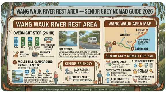
2. Free Camping — Know the 20-Hour Limit
Wang Wauk Rest Area is a NSW government-managed highway rest area. It is free to use and open 24 hours, but like all NSW highway rest areas, the maximum permitted stay is 20 hours in any 24-hour period. This is not a campground, and it is not designed for multi-night stays.
The rest area is intended for driver fatigue management. You are permitted to sleep overnight, which is strongly encouraged by Transport for NSW as a road safety measure. What you are not permitted to do is use it as a base camp for several days. Keep your stay within the 20-hour window and leave the space available for other travellers.
- Maximum stay: 20 hours
- Cost: Free
- Bookings: Not required
- Camping (formal): Not permitted — this is a rest area, not a campground
- Fires: Not permitted
- Pets: See Pets section below
3. Quick Facts and Key Details 2026
| Detail | Information |
|---|---|
| Location | Pacific Highway, Wang Wauk NSW 2423 |
| Nearest Town (North) | Taree — approx. 55 km north |
| Nearest Town (South) | Bulahdelah — approx. 22 km south |
| Nearest Town (East) | Forster/Tuncurry — approx. 38 km east via Failford Road |
| GPS Coordinates | -32.2583, 152.1922 (approximate — verify on arrival) |
| Cost | Free |
| Maximum Stay | 20 hours (NSW highway rest area rule) |
| Road Surface to Site | Sealed — direct Pacific Highway access |
| Suitable for Caravans | Yes — large bays, flat surface |
| Suitable for Big Rigs / Motorhomes | Yes — heavy vehicle bays available |
| Toilets | Yes — pit/vault toilets on site |
| Picnic Tables | Yes |
| Barbecues | No |
| Drinking Water | No — bring your own |
| Power | No |
| Dump Point | No — nearest at Bulahdelah or Forster |
| Phone Signal | Patchy — Telstra best, Optus/Vodafone limited |
| Fires | Not permitted |
| Pets | Permitted on leash — check state forest rules |
| Nearest Fuel (South) | Bulahdelah — approx. 22 km |
| Nearest Fuel (North) | Coolongolook or Taree — approx. 20–55 km |
📡 GPS Coordinates — Wang Wauk Rest Area
-32.2583, 152.1922
These are publicly available approximate coordinates. Always verify with Live Traffic NSW before travel and confirm the actual bay entry on arrival. Coordinates sourced from publicly available mapping data.
4. How to Get There + GPS Coordinates
Travelling Northbound on the Pacific Highway
From Bulahdelah (approximately 22 km south), continue north on the Pacific Highway (A1). The Wang Wauk Rest Area is signed on the left-hand side (westbound pull-off bay configuration for northbound traffic). Watch for the highway rest area signage well in advance — at highway speeds, the turn-in appears quickly after the Wang Wauk locality signs.
Real traveller note: “Heading north toward Port Macquarie, we almost missed the entry the first time. The signage is adequate but you need to be watching for it around the 22 km mark out of Bulahdelah. Once you’re in, the bays are long and flat — no trouble at all with the van.”
Travelling Southbound on the Pacific Highway
From Taree (approximately 55 km north) or Coolongolook (approximately 20 km north), travel south on the Pacific Highway. The rest area entry for southbound travellers is on the left (eastbound pull-off). Both directions have separate bay configurations — do not attempt to cross the median or turn across traffic.
From Forster / Tuncurry (East)
If approaching from Forster, travel west on Failford Road (approximately 38 km) to join the Pacific Highway, then turn north or south as required. Failford Road is a sealed two-lane rural road — suitable for caravans but take care through the township sections and at the Pacific Highway merge. Allow extra time if towing.
Entry and Turning Space
- Entry is a sealed dedicated deceleration lane — no sharp turns required
- Bays are long-pull-through style in the heavy vehicle section
- Standard caravans and motorhomes have ample room to manoeuvre
- Wide-load vehicles or B-doubles should use the designated heavy vehicle area
- The surface within the rest area is sealed and flat — no gravel or rough ground
📍 Interactive map — find free camps, rest areas and overnight stops near Wang Wauk. Enable location for best results.
5. Road Conditions, Flooding and Sealed vs Unsealed
Pacific Highway — Main Access Road
The Pacific Highway (A1) through the Wang Wauk section is a fully sealed, dual-carriageway highway. Road conditions are generally excellent year-round. The highway has been progressively upgraded and the Wang Wauk section benefits from the same modern highway standards as the broader Pacific Highway Upgrade program completed in recent years.
Sealed Roads to and from Wang Wauk
| Route | Road Surface | Flood Risk | Notes |
|---|---|---|---|
| Pacific Hwy north to Taree | Sealed dual carriageway | Low | Well-maintained, good shoulders |
| Pacific Hwy south to Bulahdelah | Sealed dual carriageway | Low | Straight and easy |
| Failford Road east to Forster | Sealed two-lane rural | Low–Moderate | Some narrow sections through forest — take care when towing |
| Wang Wauk State Forest tracks | Unsealed gravel/dirt | Moderate–High | 4WD recommended in wet weather — NOT suitable for caravans |
Wang Wauk State Forest Tracks — Important Warning
If you do explore the forest tracks — be prepared:
- Tell a responsible person your route and expected return time
- Carry recovery gear (tow straps, shovel, traction boards)
- Carry extra food and drinking water for the day
- You may encounter fallen trees, deep wash-outs, or unmarked road damage
- A locked gate means no access — do not force entry
- Country gate rule: Leave gates as you find them — open stays open, closed gets closed behind you
For up-to-date road conditions before travel, always check: livetraffic.com (NSW) and Bureau of Meteorology.
6. Heat, Climate and Remoteness — Senior Safety
Wang Wauk sits within a coastal forest zone where temperatures are moderated by proximity to the ocean and the shade of the surrounding eucalypt canopy. This is markedly different from inland NSW rest stops, and the forest setting makes a significant difference to comfort during warm months.
Seasonal Temperature Guide
| Season | Typical Temp Range | Comfort Level | Notes |
|---|---|---|---|
| Summer (Dec–Feb) | 22°C – 34°C | Warm to hot | Humidity can be high; afternoon storms possible |
| Autumn (Mar–May) | 16°C – 28°C | Excellent | Best travel season; dry and comfortable |
| Winter (Jun–Aug) | 8°C – 20°C | Very good | Cool nights; warm days; minimal rain |
| Spring (Sep–Nov) | 14°C – 26°C | Very good | Wildflowers in forest; mild and pleasant |
Remoteness factor: Wang Wauk is not truly remote — you are on or immediately adjacent to the Pacific Highway with passing traffic. In a genuine emergency, flagging down a truck or fellow traveller is a realistic option. However, mobile phone coverage is patchy, and you should not rely on your phone for emergencies without checking signal on arrival.
7. Wildlife — Birds, Reptiles and What to Watch For
The Wang Wauk State Forest corridor is home to a rich variety of coastal and forest wildlife. The rest area’s forest edge position makes it an excellent spot for birdwatching, particularly in the early morning hours before highway traffic picks up.
Birds You May See
- Glossy Black-Cockatoo — listed as vulnerable; feeds in casuarina trees
- Yellow-tailed Black-Cockatoo — large and distinctive; common in forest edges
- Gang-gang Cockatoo — less common but reported in forest areas
- Laughing Kookaburra — ever-present; good alarm clock substitute
- Eastern Whipbird — heard more than seen; distinctive cracking call
- Superb Lyrebird — occasionally seen in forest undergrowth near creek areas
- Satin Bowerbird — males distinctive blue-black; look near forest floor
- Wedge-tailed Eagle — soaring overhead, especially in warmer months
Reptiles and Other Wildlife
- Eastern Brown Snake — highly venomous; common in warm months
- Red-bellied Black Snake — near water and damp areas
- Carpet Python — non-venomous but large; often in tree forks
- Blue-tongued Lizard — often seen basking on warm surfaces
- Lace Monitor (Goanna) — can be bold around rest areas; do not feed
8. What Other Websites Don’t Tell You
Most generic camping websites list Wang Wauk Rest Area with a single line — “toilets, free, Pacific Highway.” What they don’t tell you is the practical detail that makes the difference between a comfortable stop and an annoying one.
- Highway noise: The Pacific Highway is busy, particularly with heavy vehicles overnight. Light sleepers should bring earplugs or position their van on the far side of the bay away from the highway edge.
- Toilet maintenance: Rest area toilets are maintained by Transport for NSW but cleaning frequency can vary. Carry your own toilet paper and hand sanitiser — do not assume supplies will be stocked.
- No water on site: This is consistently not mentioned in most guides. There is NO drinking water at Wang Wauk Rest Area. Arrive with full tanks. Nearest water refill is Bulahdelah (22 km south) or Coolongolook/Taree to the north.
- Truck bays are separate: The heavy vehicle bays and light vehicle bays are configured separately. Grey nomads in motorhomes or caravans should aim for the light vehicle section — the truck bays are fine structurally but diesel engine idling from overnight parked trucks can be noisy.
- Afternoon is busiest: Between 3pm and 6pm this stop becomes noticeably busier as travellers break their afternoon drive. If you want a quieter spot, arrive by 1–2pm or later in the evening.
- Morning mist: In autumn and winter, low mist rolls through from the forest. It’s beautiful — but it also means morning condensation. Check tyre pressures before leaving and allow time for windscreen visibility to clear.
9. Best Time to Visit — Month-by-Month Breakdown
| Month | Weather | Crowd Level | Notes |
|---|---|---|---|
| January | Hot, humid | High | School holidays — very busy on highway |
| February | Hot, storm risk | Moderate | Afternoon thunderstorms possible |
| March | Warm, improving | Moderate | Excellent start to autumn travel window |
| April | Mild and dry | Low–Moderate | ⭐ Ideal — Easter may spike briefly |
| May | Mild and dry | Low | ⭐ Ideal — grey nomad season opens |
| June | Cool, clear | Low | ⭐ Excellent — quiet, comfortable nights |
| July | Cool, clear | Moderate | School holidays bring more families |
| August | Mild, warming | Low–Moderate | Good birding month |
| September | Warm, pleasant | Low | ⭐ Wildflowers beginning |
| October | Warm, pleasant | Moderate | Increasing traffic as season picks up |
| November | Warm, humid building | Moderate | Fine but humidity increasing |
| December | Hot, humid | Very High | School holidays — avoid if possible |
10. Free and Low-Cost Camping Alternatives Nearby
Wang Wauk Rest Area is one stop in a broader network of free and low-cost overnight options along this section of the Mid North Coast. Our full Bulahdelah to Forster Free Camping hub covers this corridor in detail — including Bulahdelah Rest Area and Billabong Creek Rest Area to the south.
- Bulahdelah Rest Area — approx. 22 km south on the Pacific Highway. Larger facilities, close to town services. See our full guide at retiretovanlife.com/bulahdelah-rest-area/
- Billabong Creek Rest Area — south of Bulahdelah on the Pacific Highway. Free overnight. See retiretovanlife.com/billabong-creek-rest-area/
- Coolongolook Rest Area — approx. 20 km north. Small roadside stop, limited facilities.
- Forster Caravan Park area (Lions Park) — day use only; no overnight. Check with council for current rules.
- Myall Lakes National Park campgrounds — various options east via Bulahdelah. Fees apply. Booking via NSW National Parks.
🌿 Myall Lakes National Park — Worth the Detour
If you have a day to spare, the Myall Lakes National Park is accessible east of Bulahdelah and offers some of the most beautiful coastal camping in NSW. Fees apply and bookings are required in peak season. Suitable for caravans in designated campgrounds — confirm access before travel.
Visit: nationalparks.nsw.gov.au
11. Dump Points Near Wang Wauk Rest Area
There is no dump point at Wang Wauk Rest Area. The nearest options are:
| Location | Distance | Direction | Notes |
|---|---|---|---|
| Bulahdelah (Myall Way tourist park area) | ~22 km | South | Check current availability — verify on arrival |
| Forster (Council dump point) | ~38 km | East | Located near the Forster Tuncurry area — verify current location via Campermate |
| Taree (Council dump point) | ~55 km | North | Available — check Campermate for current details |
12. Free Water Sources Near Wang Wauk
There is no drinking water available at Wang Wauk Rest Area. Plan accordingly. This is one of the most commonly overlooked details for grey nomads stopping here for the first time.
Nearest Water Fill Options
- Bulahdelah: Tap water available at the Bulahdelah caravan park and at the public area near the town park — approx. 22 km south. Free.
- Coolongolook: Small service stop — may have water; confirm locally. Approx. 20 km north.
- Taree: Full town services with multiple water access points. Approx. 55 km north.
- Forster: Town water available. Approx. 38 km east via Failford Road.
13. Fuel Stops Along the Pacific Highway
Fuel planning is straightforward along this section of the Pacific Highway — you are not in a remote area and fuel is available in each direction. However, prices vary significantly between small highway towns and larger centres, so check PetrolSpy.com.au before committing to a fill-up.
| Direction | Town / Station | Approx. Distance | Fuel Types | Notes |
|---|---|---|---|---|
| South | Bulahdelah | ~22 km | ULP, Diesel, LPG | Multiple options in town; competitive pricing |
| South | Hexham / Newcastle | ~130 km | All types | Major city pricing — often cheaper than regional towns |
| North | Coolongolook | ~20 km | ULP, Diesel | Small highway servo; limited hours — check before relying on it |
| North | Taree | ~55 km | All types including LPG | Largest centre — best pricing and availability north of Wang Wauk |
| North | Port Macquarie | ~135 km | All types | Major regional city — full range available |
| East | Forster / Tuncurry | ~38 km | ULP, Diesel | Via Failford Road; coastal town pricing |
14. Caravan Parks — Paid Alternatives Nearby
If the rest area is full, noisy, or you simply want power and a hot shower, these are the nearest paid options:
| Park | Location | Approx. Distance | Powered Sites (approx.) |
|---|---|---|---|
| Bulahdelah Myall Way Tourist Park | Bulahdelah | ~22 km south | From ~$40–$50/night |
| Forster Beach Caravan Park | Forster | ~38 km east | From ~$45–$65/night (peak higher) |
| Tuncurry Beach Holiday Park | Tuncurry | ~40 km east | From ~$45–$60/night |
| Taree Showground / Caravan Park | Taree | ~55 km north | From ~$30–$45/night (showground donation basis — verify) |
Free campsites and powered sites fill fast during school holidays and peak season. If your preferred site is already taken, search accommodation options below for the Forster, Bulahdelah, or Taree area.
Accommodation search powered by Expedia. Booking through this search supports this website at no extra cost to you.
15. Full Facilities Comparison Table
| Facility | Wang Wauk Rest Area | Bulahdelah Rest Area | Forster Caravan Park |
|---|---|---|---|
| Cost | Free | Free | From ~$45/night |
| Maximum Stay | 20 hours | 20 hours | Open-ended |
| Toilets | ✅ Yes (vault) | ✅ Yes | ✅ Yes (flushing) |
| Showers | ❌ No | ❌ No | ✅ Yes |
| Drinking Water | ❌ No | ✅ Yes | ✅ Yes |
| Power | ❌ No | ❌ No | ✅ Yes |
| Dump Point | ❌ No | Check locally | ✅ Yes |
| Picnic Tables | ✅ Yes | ✅ Yes | ✅ Yes |
| Shade | ✅ Forest shade | ✅ Yes | Varies by site |
| Caravan Suitable | ✅ Yes | ✅ Yes | ✅ Yes |
| Heavy Vehicle | ✅ Yes | ✅ Yes | Check park |
| Phone Signal | ⚠️ Patchy | ✅ Moderate | ✅ Good |
| Fires | ❌ No | ❌ No | Check park rules |
16. Rates — All Options Near Wang Wauk 2026
| Option | Cost Per Night | Notes |
|---|---|---|
| Wang Wauk Rest Area | Free | 20-hour max — no bookings |
| Bulahdelah Rest Area | Free | 20-hour max — see full guide |
| Billabong Creek Rest Area | Free | 20-hour max — see full guide |
| Myall Lakes NP campgrounds | ~$10–$20 pp | Fees apply — book via NPWS |
| Bulahdelah Myall Way Tourist Park | From ~$40 | Unpowered; powered from ~$50 |
| Forster Beach Caravan Park | From ~$45 | Peak season significantly higher |
| Taree Showground | ~$20–$35 donation basis | Verify current arrangement directly |
17. Senior Safety Checklist — Wang Wauk Rest Area
- Check tyre pressures — morning condensation can affect tyre temp readings
- Confirm you have at least 10 litres drinking water per person on board
- Top up fuel before departing — nearest fuel Bulahdelah (22 km south) or Coolongolook (20 km north)
- Check Live Traffic NSW for current road conditions before pulling back onto the highway
- Check phone signal — if poor, re-connect before you need emergency services
- Empty grey water into designated waste area or hold until next dump point
- Check all exterior fittings, awnings and connections before hitching caravan
- Leave picnic area clean — pack out all rubbish
- Ensure toilet block is left in the condition you found it
- Check weather forecast — bom.gov.au
- Advise your travel companion or contact of your next intended stop
- Medications — ensure morning doses are taken before a long drive
- Confirm any prescription medications are in accessible storage, not locked in the van
18. What to Do Near Wang Wauk — Senior Activity Guide
Within the Rest Area and Immediate Surroundings
- Birdwatching: The forest edge is excellent early morning. Bring binoculars. Yellow-tailed Black-Cockatoos are frequently heard and seen.
- Gentle forest walks: Short walks into the forest edge from the rest area are possible — wear closed shoes and stick to visible tracks.
- Photography: The eucalypt forest provides excellent light in the early morning — good for landscape and wildlife photography.
- Rest and recharge: Genuinely — this is what the stop is for. A proper 1–2 hour rest breaks a long highway drive and dramatically reduces fatigue risk.
Day Trips Within 40 km
- Forster and Tuncurry (38 km east): Beautiful twin coastal towns on a sand bar. Beaches, fishing, cafes, markets (check local listings). Excellent for a half-day trip.
- Bulahdelah (22 km south): Charming timber-town feel. Myall River access for fishing and kayaking. Café and pub lunch options.
- Myall Lakes National Park: Accessible via Bulahdelah. Boating, birdwatching, and swimming in pristine lake systems. Day use free — camping fees apply.
- Taree (55 km north): Manning River and full regional town services. Riverside walking, farmers markets, gallery visits.
- Crowdy Bay National Park (via Taree, ~90 km north): Dramatic coastal scenery, seabird colonies, excellent walking for those with good mobility.
19. 🗺️ Vanlife Savings Spots — GPS Coordinates and Postcodes
The Retire to Van Life Vanlife Savings Spots system lets you save every free stop, rest area, and budget overnight to your personal map as you travel. Below are the key spots in this corridor, ready to copy into your GPS or save using the interactive map above.
| Location | Postcode | Latitude | Longitude | Notes | Nearby WiFi |
|---|---|---|---|---|---|
| Wang Wauk Rest Area | 2423 | -32.2583 | 152.1922 | Free, 20hr max, Pacific Hwy, toilets, no water | None on site — Bulahdelah or Forster for WiFi |
| Bulahdelah Rest Area | 2423 | -32.4081 | 152.2094 | Free, 20hr max, toilets, water | Bulahdelah township — McDonald’s / library |
| Billabong Creek Rest Area | 2420 | -32.5240 | 152.1811 | Free, 20hr max, basic facilities | Nil on site |
| Coolongolook Rest Area | 2423 | -32.1818 | 152.2358 | Small roadside stop, limited facilities | Nil |
| Forster (town centre) | 2428 | -32.1808 | 152.5148 | Full town — fuel, water, dump point, shops | Forster Library WiFi, McDonald’s |
| Taree (Manning River) | 2430 | -31.9000 | 152.4551 | Full regional services — hospital, fuel, all amenities | Taree Library WiFi, McDonald’s, multiple cafes |
COPY PROMPT ➔ ASK AI ➔ SAVE TO FORM ➔ ADD SPOT PIN ➔ GET DIRECTIONS
20. Phone Signal and Emergency Communications
Phone coverage at Wang Wauk Rest Area is patchy and unreliable. The forest location and highway corridor create variable reception depending on your exact position in the bay and your carrier.
| Carrier | Coverage Quality | Notes |
|---|---|---|
| Telstra | ⭐⭐⭐ Moderate | Best option in this area — 3G/4G possible but not guaranteed |
| Optus | ⭐⭐ Limited | May drop in and out — do not rely on for emergencies |
| Vodafone / TPG | ⭐ Poor | Very limited in forest areas — may have no signal |
Nearest Public WiFi
- Bulahdelah: Library (check hours) and fast food options if present — 22 km south
- Forster: Forster Library — free public WiFi — 38 km east
- Taree: Taree Library, McDonald’s — 55 km north
21. Campfires, Cooking Restrictions and Food Nearby
Fires — Strictly Prohibited
During declared Total Fire Ban days, even gas cookers may be restricted in some configurations — check with NSW Rural Fire Service at rfs.nsw.gov.au for current conditions during your travel period.
Cooking at Wang Wauk
- Gas cookers (self-contained, in a van or on a table) — generally acceptable
- Electric induction (if you have solar/battery) — acceptable
- No wood fires, no charcoal, no open flame pits
- No electric barbecues on site — if you want a BBQ, head to Bulahdelah or Forster parks
Food and Supplies Nearby
| Direction | Town | Distance | Food Options |
|---|---|---|---|
| South | Bulahdelah | ~22 km | Supermarket (IGA), bakery, pub, takeaway, cafes |
| East | Forster/Tuncurry | ~38 km | Full supermarket, restaurants, cafes, fish and chips |
| North | Coolongolook | ~20 km | Highway servo snacks only |
| North | Taree | ~55 km | Full regional city — Woolworths, Coles, all options |
22. Pets at Wang Wauk Rest Area
Pets are generally permitted at NSW highway rest areas, including Wang Wauk, provided they are kept on a leash at all times. However, the rest area is adjacent to Wang Wauk State Forest, and different rules may apply for animals entering State Forest land.
- Pets on leash: ✅ Permitted in the rest area
- Pets in adjacent State Forest: ✅ Permitted on leash
- Pets in Myall Lakes National Park: ❌ Not permitted (National Park rules)
- Always clean up after your pet — no exceptions
- Carry pet water — no water available on site
- Snake risk is real — keep dogs away from long grass, log piles, and undergrowth
23. Accessibility for Seniors with Mobility Limitations
Wang Wauk Rest Area has been designed with basic accessibility standards, though it is not a fully equipped accessible facility. Grey nomads with mobility limitations should be aware of the following:
| Feature | Status | Notes |
|---|---|---|
| Flat sealed parking | ✅ Yes | Bays are level — easy to deploy step or ramp |
| Accessible toilet | ⚠️ Verify on arrival | Standard vault toilet — may not be wheelchair accessible |
| Picnic tables | ✅ Yes | Standard height — not always accessible for wheelchair users |
| Path surfaces | ⚠️ Mixed | Some gravel or compacted earth paths between bays and facilities |
| Steps or kerbs | ⚠️ Possible | Verify on arrival — kerb drops at some rest areas are not full-width |
| Walker / mobility aid suitable | ✅ Generally yes | Flat sealed areas suitable for walkers and rollators |
24. Camping Permits, Fees, Etiquette and Waste Management
Permits and Fees
No permit is required to use Wang Wauk Rest Area. No payment is required. Simply pull in, use the facilities, and depart within 20 hours. There is no ranger presence, no check-in, and no booking system.
Leave No Trace — Etiquette for Grey Nomads
- Pack out all rubbish — there may be bins, but they fill quickly. Carry a rubbish bag and take it with you if bins are full.
- No grey water on the ground — do not dump grey water at the rest area. Hold it until you reach a dump point.
- No black water disposal — absolutely prohibited. Use your cassette or black tank properly and empty at a designated dump point.
- Quiet hours — generators and loud noise are inconsiderate at overnight rest areas. Keep generator use to essential periods only and be mindful of other travellers.
- Leave bays clear — do not spread your setup across multiple bays. Use one bay, leave others available for new arrivals.
- Respect wildlife — do not feed goannas, birds, or any wildlife. It changes their behaviour and makes them a nuisance for future travellers.
25. Emergency Scenarios — What to Do
Medical Emergency
Taree Base Hospital is the nearest major hospital — approximately 55 km north on the Pacific Highway. Manning Base Hospital serves the Mid North Coast region. In an emergency, call Triple Zero (000) immediately and state your location as “Wang Wauk Rest Area, Pacific Highway, Wang Wauk NSW 2423.” Describe which direction bays you are in (northbound or southbound) to help emergency services locate you quickly.
Vehicle Breakdown
- Call your roadside assistance provider (NRMA, RAA, RACQ, etc.)
- Place hazard triangles or warning devices at a safe distance behind your vehicle if parked near traffic flow
- Remain in your vehicle or well away from the highway — do not stand on the highway edge
- Nearest tow services: Bulahdelah (22 km south) and Taree (55 km north)
Fire Emergency
NSW Rural Fire Service: rfs.nsw.gov.au — 1800 NSW RFS. If fire threatens the rest area, exit to the Pacific Highway immediately and drive away from the fire front. Do not shelter in place in a vehicle if fire is approaching.
Flash Flooding
If heavy rain causes localised flooding on the highway, do not attempt to drive through water over the road. Check Live Traffic NSW for closures. Wait at the rest area until conditions clear or seek alternative routing via advice from Live Traffic NSW.
Snakebite
- Call Triple Zero (000) immediately
- Keep the patient still and calm — movement accelerates venom spread
- Apply a pressure immobilisation bandage if trained to do so
- Do not cut, suck, or attempt to treat the bite
- Identify the snake species if safe to do so (photograph from distance) for antivenin selection
26. Packing List for This Section of Highway
- Minimum 10 litres drinking water per person (no water on site)
- Toilet paper and hand sanitiser (facilities may not be stocked)
- Gas cooker and fuel — no electric BBQ on site
- Insect repellent — forest edge brings mosquitoes at dawn/dusk
- Closed-toe footwear — for walking around the rest area (snake protection)
- Earplugs — highway traffic noise overnight
- First aid kit including pressure bandages (snakebite protocol)
- Torch or headlamp — toilet block may not be lit at night
- Rubbish bags — take your rubbish with you if bins are full
- Phone charger / power bank — patchy signal may drain battery
- Paper map or downloaded offline map — do not rely on data signal
- PLB or satellite communicator (strongly recommended for seniors travelling alone)
- Spare fuel or confident knowledge of nearest fuel stop distance
- Binoculars — birdwatching opportunity is excellent here
27. 5 Rest Areas Near Wang Wauk Rest Area
- Bulahdelah Rest Area — 22 km south on Pacific Highway. Free, 20 hr max, toilets, water, picnic tables. Full guide: retiretovanlife.com/bulahdelah-rest-area/
- Billabong Creek Rest Area — South of Bulahdelah on the Pacific Highway. Free, 20 hr max, basic facilities. Full guide: retiretovanlife.com/billabong-creek-rest-area/
- Coolongolook Rest Area — Approx. 20 km north of Wang Wauk on the Pacific Highway. Small stop, basic facilities. Useful as a short break only.
- Taree Truck Stop / Rest Area (Coopernook) — Approx. 45–55 km north. Larger rest area complex with heavy vehicle facilities. Free.
- Karuah Rest Area — South of Bulahdelah (approx. 70 km south near Karuah). On the Pacific Highway northbound/southbound. Free, 20 hr max. Useful for travellers heading to/from Newcastle.
28. Reviews — What Grey Nomads Say About Wang Wauk Rest Area
“We pulled in at about 2pm on a Wednesday in May — three other vans already there but plenty of room. The forest shade made it genuinely cool and comfortable. Toilets were clean enough. No water on site as others warned, but we were prepared. Would definitely stop again.”
“Good stop for a break but the truck noise through the night was more than we expected. Bring earplugs. On the positive side, the bays are long and flat — no trouble with our 8.5 metre van. The morning birds were spectacular — black cockatoos right overhead at dawn.”
“Perfect midday stop on the way to Forster. We had lunch, stretched the legs, watched a goanna investigate the next bay over. No water so make sure you’re stocked up. The table and shade were all we needed for an hour’s break. Would not pay $50 for a caravan park just for one night when this is perfectly adequate.”
“Had phone issues — Optus basically useless here. If you need to make calls, move closer to Bulahdelah or Coolongolook. Rest area itself was fine for an overnight. Clean, flat, forest feels nice. Just come prepared.”
29. Frequently Asked Questions — Wang Wauk Rest Area
Can I stay overnight at Wang Wauk Rest Area?
Yes. Wang Wauk Rest Area permits overnight stays as a NSW highway rest area. The maximum permitted stay is 20 hours in any 24-hour period under NSW road rules. It is free. This is a driver fatigue management facility — not a campground.
Is there water at Wang Wauk Rest Area?
No. There is no drinking water on site. Bring a minimum of 10 litres per person. Nearest water is Bulahdelah (22 km south) or Coolongolook (20 km north).
Is Wang Wauk Rest Area suitable for large caravans and motorhomes?
Yes. The rest area has long, flat, sealed bays suitable for caravans, motorhomes, and heavy vehicles. Separate heavy vehicle bays are available. No tight turns or reversing required in most configurations.
Does the road to Wang Wauk flood?
The Pacific Highway section accessing Wang Wauk does not routinely flood, but localised water over the road can occur during major rainfall events. Always check Live Traffic NSW before travel during summer and autumn.
Are dogs allowed at Wang Wauk Rest Area?
Yes, on a lead. Dogs are permitted in State Forests (unlike National Parks). Keep dogs leashed at all times — snake risk is real in this forest environment.
Is there mobile phone coverage at Wang Wauk?
Coverage is patchy. Telstra is the best carrier in this area but is not guaranteed. Optus and Vodafone are limited. Do not rely on mobile coverage for emergency communication — carry a PLB if travelling alone.
Is there a dump point at Wang Wauk?
No. Nearest dump points are Bulahdelah (22 km south), Forster (38 km east), and Taree (55 km north). Verify current availability via Campermate or WikiCamps before travel.
Can I light a campfire at Wang Wauk?
No. Open fires are not permitted at the rest area or within Wang Wauk State Forest without a permit. Gas cooking is acceptable. Always check NSW RFS for Total Fire Ban days.
What is the nearest hospital to Wang Wauk?
Manning Base Hospital, Taree — approximately 55 km north on the Pacific Highway. In an emergency, call Triple Zero (000).
Is RV LIFE Trip Wizard available for planning this route in Australia?
Note for Australian travellers: RV LIFE Trip Wizard is a USA-based RV trip planning tool. It is primarily designed for North American travel. Australian grey nomads will find it less useful for local route planning. Australian-specific apps such as Campermate, WikiCamps, and Hema Explorer are better suited for planning travel in NSW and along the Pacific Highway corridor. US visitors to Australia may find RV LIFE familiar but should switch to Australian tools for local navigation.
30. Quick-Reference Card — Wang Wauk Rest Area 2026
📋 Wang Wauk Rest Area — At a Glance
| Address | Pacific Highway, Wang Wauk NSW 2423 |
| GPS | -32.2583, 152.1922 (approximate — verify) |
| Cost | Free |
| Max Stay | 20 hours |
| Toilets | Yes — vault/pit style |
| Water | No — bring your own |
| Power | No |
| Fires | No — prohibited |
| Dump Point | No — Bulahdelah 22 km S, Forster 38 km E |
| Fuel South | Bulahdelah — 22 km |
| Fuel North | Coolongolook — 20 km / Taree — 55 km |
| Hospital | Manning Base Hospital, Taree — 55 km N |
| Emergency | Triple Zero — 000 |
| Phone | Telstra best — patchy overall |
| Road to site | Sealed — Pacific Highway direct |
| Caravan suitable | Yes — flat, long bays |
| Pets | On leash — permitted |
| Live Traffic NSW | livetraffic.com |
| Weather | bom.gov.au |
| Fuel prices | petrolspy.com.au |
| Dump points | campermate.com.au |
| Rest areas | wikicamps.com.au |
🔒 Protect Your Van or Motorhome While You Sleep
Exclusive Offer: Get 5% OFF all StarterStopper immobiliser products with promo code: RTV5
Visit StarterStopper.com — data-backed vehicle security solutions
As an affiliate, I earn from qualifying purchases at no extra cost to you.
🇺🇸 RV LIFE Trip Wizard — For US Visitors Only
Please note: RV LIFE Trip Wizard is a North American trip planning tool. It is designed for travel in the United States and Canada. Australian grey nomads should use Campermate, WikiCamps, or Hema Explorer for local trip planning. US visitors travelling Australia may find this a familiar interface but will need to switch to Australian mapping tools for accurate local navigation.

As an affiliate, I earn from qualifying purchases at no extra cost to you.
Disclaimer
Accuracy and Verification: All information in this guide was accurate to the best of our knowledge at the time of publication (January 2026). Road conditions, facility availability, phone coverage, dump point locations, caravan park pricing, and rest area rules can change without notice. Always verify current conditions before travel using the official sources linked throughout this article.
GPS Coordinates: GPS coordinates provided in this article are approximate and sourced from publicly available mapping data. They should be used as a guide only. Always confirm your exact location on arrival. Do not rely solely on GPS for navigation in unfamiliar areas.
Emergency Information: Always call Triple Zero (000) in an emergency. The information in this article is provided for general travel planning purposes and does not constitute professional medical, legal, or safety advice.
Affiliate Links: This article contains affiliate links to Expedia, StarterStopper, and RV LIFE. Clicking these links and making a purchase may earn this website a commission at no additional cost to you. This does not influence editorial content.
No Liability: Retire to Van Life accepts no liability for loss, injury, or inconvenience arising from use of the information in this guide. Travel at your own risk and always exercise appropriate judgement for your personal circumstances.
© 2026 Retire to Van Life — retiretovanlife.com
- Live Traffic NSW — livetraffic.com
- Bureau of Meteorology — bom.gov.au
- PetrolSpy — petrolspy.com.au
- Campermate — campermate.com.au
- WikiCamps — wikicamps.com.au
- Google Maps — Wang Wauk Rest Area
- NSW Rural Fire Service — rfs.nsw.gov.au
- NSW National Parks — nationalparks.nsw.gov.au
- Bulahdelah to Forster Free Camping Guide — Retire to Van Life
© 2026 Retiretovanlife.com — All rights reserved. Written for Senior Grey Nomads. Safe travels. 🚐