Home › Free Camping & Rest Areas › Mooki River Rest Area
✅ Last updated: March 2026. Written for Australian senior grey nomads travelling the Newell Highway
Mooki River Rest Area — Free Camping on the Newell Highway: Senior Grey Nomad Guide 2026
Is the Mooki River Rest Area safe, genuinely free and suitable for senior caravanners in 2026 — and does it flood? Here is the honest answer before you pull off the Newell Highway.
- Location: Newell Highway, Mooki River crossing, near Quirindi NSW 2343
- GPS: Approximately -31.5087, 150.6391 (approx — verify in Google Maps before departure)
- Cost: Free — no permit or booking required
- Stay Limit: 24 hours recommended (Transport for NSW rest area — confirm on-site signage)
- Toilets: ✅ Yes — pit/drop toilets on site
- Drinking Water: ❌ None on site — fill tanks in Quirindi (~10 km south) or Werris Creek (~20 km north)
- Mains Power: ❌ None — CPAP users must have battery backup or generator
- Dump Point: ❌ Not on site — nearest in Quirindi (~10 km south)
- Telstra Signal: ⚠️ Generally reasonable on the highway; can be patchy in the river valley
- Flood Risk: ⚠️ Yes — sits adjacent to the Mooki River; check conditions after rain
- Nearest Hospital: ⛑️ Quirindi Community Hospital — ~10 km south | (02) 6746 1200
- Pets: ✅ Allowed on leash — supervise near the river
- Road Surface: ✅ Fully sealed — Newell Highway direct access
- Big Rigs & Caravans: ✅ Suitable — heavy vehicle rest area design
📋 Table of Contents
- What Is the Mooki River Rest Area and Where Does It Sit?
- The Honest Truth for Seniors — What Looks Easy But Isn’t
- How to Get to the Mooki River Rest Area — Road Conditions and Access
- Mooki River Rest Area — Full Facilities, GPS and Access Details
- Is a Permit or Fee Required?
- What the Mooki River Rest Area Doesn’t Tell You Online
- Fires, Generators and Noise Rules
- Free and Low-Cost Camping Near the Mooki River
- Dump Points on Your Route — Before and After the Mooki River Rest Area
- Free Potable Water — GPS Before and After the Mooki River
- Quirindi and Tamworth as Your Alternative Senior Base
- Full Facilities Comparison: Mooki River vs Quirindi vs Tamworth
- Monthly Weather and Best Time to Visit
- Wildlife and Nature at the Mooki River
- Fuel Stations — Distances North, South, East and West
- Senior Day Plan — Making the Most of a Mooki River Stop
- Senior Checklist — Mooki River Rest Area Stop
- Safety and Emergency Plan
- What Grey Nomads Say
- GPS Master Table — Every Location in This Guide
- Frequently Asked Questions — Mooki River Rest Area
- Quick-Reference Card — Save Before You Leave
1. Mooki River Rest Area and the Newell Highway: Why Grey Nomads Stop Here
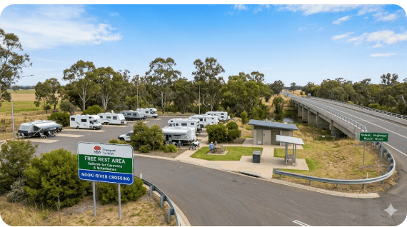
The Mooki River Rest Area sits on the Newell Highway at the Mooki River crossing, just north of the town of Quirindi in the Liverpool Plains region of New South Wales. For grey nomads travelling one of Australia’s great inland highways — the Newell — this rest area marks a natural break point between the Hunter Valley and New England tablelands to the south, and Tamworth, Narrabri and beyond to the north.
The Newell Highway is the backbone route for grey nomads travelling between Melbourne and Brisbane without going coastal. It is one of the busiest inland highways in eastern Australia, and the Mooki River Rest Area is one of the most frequently mentioned stopping points on this stretch. The location is genuinely scenic by highway rest area standards — the Mooki River provides a green, tree-lined corridor in an otherwise agricultural landscape, and the sounds of running water and riverside birdlife make it a noticeably more pleasant overnight stop than a simple bitumen bay.
In 2026, the Mooki River Rest Area remains a well-known and well-used free stop for senior caravanners travelling the Newell. It appears consistently in WikiCamps and CamperMate listings with positive feedback — but like all rest areas, it has specific characteristics that senior travellers need to understand before they arrive. Chief among these is the flood risk that comes with any riverside location in eastern NSW.
2. The Honest Truth for Seniors — What Looks Easy But Isn’t
The Mooki River Rest Area is one of the more attractive roadside stops on the Newell Highway. The riverside setting, easy highway access and proximity to Quirindi make it tempting to treat as a no-fuss overnight stop. And for well-prepared travellers, it genuinely is. But there are specific realities that app listings and forum posts tend to gloss over — and senior travellers deserve the full picture.
- Flooding is a real risk. The rest area sits directly adjacent to the Mooki River. After significant rainfall in the Liverpool Range catchment, the river can rise quickly. There are documented instances of the rest area being affected by floodwater or becoming inaccessible during and after heavy rain events. Always check Live Traffic NSW before arriving after any rain — even if conditions seem fine where you currently are.
- No drinking water on site. The river water is not safe for drinking or cooking. The nearest reliable potable water is Quirindi, approximately 10 km south. Always fill tanks before arriving.
- No mains power. CPAP users without a lithium battery backup or generator will have a problem here. The nearest powered sites are in Quirindi or Werris Creek.
- No dump point on site. Manage your black water and cassette capacity before you arrive. The nearest dump point is in Quirindi, approximately 10 km south.
- Insects can be significant. A riverside location in eastern NSW means flies during the day and mosquitoes at dusk and dawn — particularly after rain and in the warmer months. Screens and repellent are essential.
- Road noise from the Newell Highway. The rest area is adjacent to a major truck route. Heavy vehicle traffic runs 24 hours. Light sleepers will notice it.
- Hospital is 10 km away — this is actually one of the better-positioned rest areas. Quirindi Community Hospital is a short drive south. However, for major emergencies, Tamworth Base Hospital (approximately 60 km north) provides a higher level of care.
The flood risk in particular sets the Mooki River Rest Area apart from a standard highway stop. It requires active checking — not just a glance at the sky. If there has been significant rain anywhere in the Liverpool Plains or Liverpool Range in the 48 hours before your arrival, check the river level and road status before committing to an overnight stay here.
3. How to Get to the Mooki River Rest Area — Road Conditions, Access and Distances
The Mooki River Rest Area is accessed directly off the Newell Highway (B84) at the Mooki River bridge, between Quirindi and Werris Creek. The entry is off the sealed highway — no unsealed road or dirt track is required at any point.
Approaching from the South (from Quirindi or Sydney)
From Quirindi, head north on the Newell Highway. The Mooki River crossing and rest area are approximately 10 km north of the Quirindi township. The highway is fully sealed, wide and in generally good condition on this section. Allow approximately 10–12 minutes from Quirindi main street to the rest area entry. The approach is straightforward with no tight turns, steep grades or narrow sections that would concern caravanners.
Approaching from the North (from Werris Creek or Tamworth)
From Werris Creek, travel south on the Newell Highway. Werris Creek is approximately 20 km north of the rest area. From Tamworth, the rest area is approximately 60 km south via the Newell Highway. The road is sealed throughout and suitable for all vehicle and caravan combinations.
Does the Road Flood Near the Mooki River Rest Area?
- The Mooki River is a tributary of the Namoi River system and drains a significant catchment area across the Liverpool Range. After heavy rain events — which can occur at any time of year but are most common between October and April — the Mooki River can rise rapidly.
- The rest area sits in the river floodplain. In significant flood events the area can become inundated or inaccessible. The Newell Highway at the bridge can itself become affected in major floods.
- Always check Live Traffic NSW at livetraffic.com or call 132 701 before arriving after any rain in this region.
- Check the Bureau of Meteorology flood warnings for the Mooki River at bom.gov.au — the BOM issues specific Mooki River flood warnings when levels are rising.
- Never drive into or through floodwater. If the access to the rest area appears flooded on arrival, do not attempt to drive in. Proceed to Quirindi or Werris Creek and wait for conditions to clear.
Is the Road to the Mooki River Rest Area Unsealed?
No. The Newell Highway is fully sealed between Quirindi and Werris Creek, including the Mooki River bridge section where the rest area is located. The rest area entry itself is also sealed. No unsealed roads are required at any point. All vehicles — including large motorhomes, fifth-wheelers and caravans — can access this rest area without difficulty in normal conditions.
4. Mooki River Rest Area — Full Facilities, GPS and Access Details
| 📍 Mooki River Rest Area — Quick Facts 2026 | |
|---|---|
| Full Name | Mooki River Rest Area |
| Address | Newell Highway, Mooki River crossing, near Quirindi NSW 2343 |
| GPS | -31.5087, 150.6391 (approx — verify in Google Maps before departure) |
| Cost | Free |
| Stay Limit | 24 hours recommended (Transport for NSW — confirm on-site signage on arrival) |
| Road Access | ✅ Fully sealed — Newell Highway direct access |
| Flood Risk | ⚠️ Yes — riverside location; check BOM and Live Traffic NSW after any rain |
| Caravans | ✅ Yes — heavy vehicle rest area design |
| Big Rigs | ✅ Yes — designed for heavy vehicles and B-doubles |
| Toilets | ✅ Pit/drop toilets — bring toilet paper and hand sanitiser |
| Drinking Water | ❌ None on site — do not use river water; fill in Quirindi (~10 km south) |
| Mains Power (240V) | ❌ None — CPAP users must carry battery backup or use generator (courteously) |
| Showers | ❌ None on site |
| Picnic Tables | ✅ Yes — standard rest area picnic furniture |
| Shade | ✅ Good — river gums and riparian vegetation provide natural shade |
| Telstra Reception | ⚠️ Generally reasonable on the highway; can be patchy in the river valley — check on arrival |
| Pets | ✅ Allowed on leash — supervise near river at all times |
| Dump Point | ❌ Not on site — nearest: Quirindi ~10 km south (confirm with Liverpool Plains Shire) |
| Nearest Hospital | ⛑️ Quirindi Community Hospital — ~10 km south | (02) 6746 1200 (verify before travel) |
| Major Hospital | ⛑️ Tamworth Base Hospital — ~60 km north | (02) 6767 7777 (verify before travel) |
| Nearest Fuel | Quirindi ~10 km south (multiple options) or Werris Creek ~20 km north |
| Managed By | Transport for NSW |
| Senior Rating | ⭐⭐⭐⭐ — One of the better-positioned Newell Highway rest areas for seniors; proximity to Quirindi services is a genuine advantage. Flood risk requires active checking after rain. |
📍 Mooki River Rest Area — Map View
Map centred on approximate GPS coordinates. Verify exact entry point on arrival. Coordinates: -31.5087, 150.6391 (approx).
5. Is a Permit or Fee Required at the Mooki River Rest Area?
No permit and no fee are required to use the Mooki River Rest Area. It is a public rest area managed by Transport for NSW and is free to use, 24 hours a day, seven days a week.
As with all Transport for NSW highway rest areas, a recommended 24-hour stay limit applies. This limit exists because the rest area is designed as a fatigue management stop — not a campground. If you need more than one overnight rest in this area, Quirindi Caravan Park or Tamworth to the north are the appropriate alternatives.
No National Parks pass is required. The rest area is not within a national park. No booking system exists — simply pull in and park safely in the designated areas. There are no rangers checking length of stay in most cases, but respecting the 24-hour guideline is the right thing to do for yourself and other travellers who may need the space.
6. What the Mooki River Rest Area Doesn’t Tell You Online
App listings tell you the basics. Here is what experienced grey nomads who have actually stopped here know — and what most online listings leave out.
The River Setting Is the Highlight — But It Has a Catch
The river gums along the Mooki River make this one of the more pleasant-looking rest areas on the Newell Highway. Travellers consistently mention the shade, the birdsong and the sound of running water as positives. What they mention less often is that the same setting brings mosquitoes at dusk — particularly between October and April when temperatures are warm and water levels are higher. A good quality insect screen for your van doorway is not optional here in summer. It is essential.
The Quirindi Proximity Is a Genuine Advantage
Unlike many rest areas on remote sections of the Newell, the Mooki River Rest Area is only 10 km from Quirindi — a town with a supermarket, fuel, a hospital, an ATM and a dump point. This proximity fundamentally changes the risk profile of stopping here. If you realise at 7:00 pm that you need something, Quirindi is a short drive away. This is a significant comfort for senior travellers who stop at rest areas further from services with no backup option.
Signal Can Drop in the River Valley
While the Newell Highway generally has reasonable Telstra coverage in this area, the river valley topography can affect signal quality at the actual rest area site. Travellers report that signal is good on the highway itself but can be patchy once you pull into the lower-lying rest area. Check your signal on arrival and do not assume it will be consistent throughout the night.
Toilet Maintenance Is Not Daily
Rest area toilets on the Newell Highway are serviced on a contractor schedule — not daily. During peak grey nomad season (June–August) when traffic through this rest area is at its highest, the pit toilets can reach capacity between service visits. Always carry your own supplies. A small portable camping toilet is a worthwhile investment for travellers who use highway rest areas frequently.
Departure Timing Matters More Than You Think
7. Fires, Generators and Noise Rules at the Mooki River Rest Area
Open Fires
Generators
No formal written generator curfew is posted by Transport for NSW for this specific rest area. However, the universal grey nomad courtesy rule applies here as it does across all highway rest areas: do not run a generator between approximately 8:00 pm and 8:00 am. Truck drivers and fellow travellers at this fatigue management stop are attempting mandatory rest. A generator running through the night is inconsiderate and will draw complaints. If you need overnight power for CPAP, a lithium battery bank charged before departure from Quirindi is the correct and courteous solution.
Noise
Treat the Mooki River Rest Area as you would any shared overnight space: quiet after sunset, music kept low or off, and vehicle movements kept to a minimum during nighttime hours. The Newell Highway itself will supply plenty of ambient noise from passing trucks — your fellow travellers do not need additional noise from your camp as well.
8. Free and Low-Cost Camping Near the Mooki River Rest Area
If the Mooki River Rest Area is flooded, full, or simply not suited to your needs on a given night, there are genuine alternatives on this stretch of the Newell Highway. For the full free camp database covering the Newell Highway corridor — including the ability to ask the AI for GPS to the nearest dump point, potable water, or next suitable free camp on your specific route — visit the Van Life Savings Spots App. It is built specifically for senior grey nomads and gives GPS-specific answers to real questions like:
- “Find me the nearest free camp to the Mooki River Rest Area with a dump point nearby”
- “What is the nearest powered site between Quirindi and Tamworth tonight?”
- “Is there potable water between Quirindi and Narrabri on the Newell Highway?”
- “Find me a quiet overnight stop on the Newell Highway suitable for a 23-foot caravan and tow vehicle”
- “Is the Mooki River Rest Area affected by flooding today?”
| Location | Distance | Cost | Notes for Seniors |
|---|---|---|---|
| Quirindi Showground / Caravan Park area Quirindi NSW 2343 Approx GPS: -31.5139, 150.6784 (approx) |
~10 km south | Low cost — powered sites available. Confirm rates with Liverpool Plains Shire Council: (02) 6746 1755 | Best option when Mooki River floods or if you need power, showers, dump point. Hospital 1 km. Supermarket nearby. Genuinely senior-friendly town. |
| Werris Creek Rest Area / Town area Werris Creek NSW 2341 Approx GPS: -31.3596, 150.6545 (approx) |
~20 km north | Free / low cost — confirm locally | Small railway town. Fuel available. Some informal stopping options. Limited services. Better suited as a fuel stop than an overnight base for seniors needing full facilities. |
| Tamworth Caravan Parks (multiple options) Tamworth NSW 2340 Approx GPS (city centre): -31.0927, 150.9320 (approx) |
~60 km north | Paid — multiple caravan parks with full facilities | Major regional city. Full services, major hospital, supermarkets, dump points, WiFi. Best choice for seniors needing full facilities or medical access on this stretch of the Newell. |
| Caroona Rest Area (Newell Hwy, north of rest area) Caroona NSW 2343 Approx GPS: -31.4029, 150.4223 (approx) |
~16 km northwest | Free — Transport for NSW rest area | Another highway rest area option on the Newell. No flooding risk as it is away from the river. No dump point, no water, no power. Suitable as an alternative overnight stop if Mooki River is not accessible. Verify current facilities before relying on this stop. |
9. Dump Points on Your Route — Before and After the Mooki River Rest Area
There is no dump point at the Mooki River Rest Area. Plan your cassette and black water tank management around the facilities in Quirindi (south) and Tamworth (north). Here are the confirmed locations on either side.
| Direction | Location | GPS (Approx) | Distance | Notes |
|---|---|---|---|---|
| 🗑️ SOUTH (Before, from Quirindi) | Quirindi Dump Point Quirindi NSW 2343 |
Approx -31.5139, 150.6784 (verify at toiletmap.gov.au) |
~10 km south | Use before heading north. Verify exact location at toiletmap.gov.au or call Liverpool Plains Shire Council: (02) 6746 1755. |
| 🗑️ ON SITE | Mooki River Rest Area | — | — | ❌ No dump point on site. |
| 🗑️ NORTH (After, toward Tamworth) | Tamworth Dump Point(s) Tamworth NSW 2340 |
Approx -31.0927, 150.9320 (verify at toiletmap.gov.au — multiple locations in Tamworth) |
~60 km north | Tamworth has multiple dump points. Verify exact location at toiletmap.gov.au or call Tamworth Regional Council: (02) 6767 5555 (verify before travel). |
- Never use the dump point rinse hose for drinking water, filling your tank, or food preparation — it is not potable.
- During peak grey nomad season on the Newell Highway (June–August), Quirindi’s dump point may have a queue during morning peak times (7:00–9:00 am). Plan extra time.
- Always carry gloves, a bucket and disinfectant spray. Hygiene standards at small-town dump points can vary significantly.
- If the Mooki River Rest Area is flood-affected and you are detouring to Quirindi anyway, use the dump point there before deciding whether to wait for the rest area to become accessible again.
10. Free Potable Water — GPS Before and After the Mooki River Rest Area
There is no potable water at the Mooki River Rest Area. The Mooki River water is not safe for drinking or cooking. Here are the confirmed potable water sources on either side.
| Location | Water Status | GPS (Approx) | Distance |
|---|---|---|---|
| 💧 Mooki River Rest Area — On Site | ❌ No potable water on site. River water is not safe for drinking. | — | — |
| 💧 Quirindi (South — before rest area) | ✅ Mains/scheme water — town taps and caravan park | Approx -31.5139, 150.6784 | ~10 km south |
| 💧 Werris Creek (North — after rest area) | ✅ Town water available — confirm access point locally | Approx -31.3596, 150.6545 | ~20 km north |
| 💧 Tamworth (North — major top-up point) | ✅ Mains water — multiple caravan parks and town facilities | Approx -31.0927, 150.9320 | ~60 km north |
- Do not drink, cook with, or fill tanks from the Mooki River. Agricultural and pastoral land surrounds this waterway and the water quality cannot be assumed safe even if it looks clean and clear.
- Never fill from an unmarked tap at a rest area. If a tap does not carry a clearly posted “Drinking Water” sign, treat it as non-potable.
- Carry a minimum of two days emergency drinking water beyond your planned daily use whenever travelling any NSW highway rest area corridor.
11. Quirindi and Tamworth as Your Alternative Senior Base
For senior travellers who need more than a basic overnight stop — or who arrive to find the Mooki River Rest Area flooded, full or not suitable — both Quirindi and Tamworth offer proper alternatives with the full range of services.
Quirindi — 10 km South
Quirindi is a pleasant Liverpool Plains agricultural town with genuine services for grey nomads. It has a supermarket, fuel stations, an ATM, a pharmacy, and the Quirindi Community Hospital on Ramsay Street. Caravan facilities are available at the showground or through local arrangements — contact Liverpool Plains Shire Council on (02) 6746 1755 for current options and rates. For senior travellers who want the Mooki River experience but with the security of being close to a hospital and town services, Quirindi is the sensible base — use the rest area for a riverside lunch stop rather than an overnight stay.
Tamworth — 60 km North
Tamworth is one of regional NSW’s great inland cities and a genuine grey nomad hub on the Newell Highway. It has multiple caravan parks with full facilities, a major supermarket precinct, a Bunnings, specialist stores, and most importantly Tamworth Base Hospital on Dean Street — one of the better-equipped regional hospitals in NSW. For seniors travelling northward through New England, Tamworth is worth spending at least two to three nights exploring the city, the Guitar Museum, the Kamilaroi walking trail along the Peel River, and the wider region.
12. Full Facilities Comparison: Mooki River Rest Area vs Quirindi vs Tamworth
| Facility / Factor | Mooki River Rest Area | Quirindi (~10 km south) | Tamworth (~60 km north) |
|---|---|---|---|
| Cost per night | ✅ Free | Low cost — confirm with Shire | Paid — multiple price points |
| Mains Power (240V) | ❌ None | ✅ Powered sites available | ✅ Multiple powered options |
| Flush Toilets / Showers | ❌ Pit toilets only | ✅ Yes at caravan park | ✅ Yes — full facilities |
| Drinking Water | ❌ None on site | ✅ Mains water — top up here | ✅ Mains water available |
| Dump Point | ❌ None | ✅ Yes — confirm location | ✅ Multiple locations |
| Telstra Signal | ⚠️ Variable in river valley | ✅ Good in town | ✅ Excellent — major regional city |
| Hospital Distance | ✅ 10 km to Quirindi | ✅ Hospital in town | ✅ Major hospital in city |
| Supermarket | ❌ None at rest area | ✅ IGA and local stores | ✅ Woolworths, Coles, Aldi |
| Flood Risk | ⚠️ Yes — river location | ✅ Low risk in town itself | ✅ Low risk at caravan parks |
| Pets | ✅ Yes — on leash | ⚠️ Confirm with caravan park | ⚠️ Confirm with each park |
| Big Rigs | ✅ Heavy vehicle design | ✅ Confirm large rig suitability | ✅ Multiple park options |
| WiFi | ❌ None | ⚠️ Limited — check library or caravan park | ✅ Available at caravan parks and library |
| Scenic Setting | ✅ Riverside — river gums, birdlife, water sounds | ⚠️ Agricultural town — pleasant but not scenic | ✅ Peel River corridor — some parks very pleasant |
13. Monthly Weather and Best Time to Visit the Mooki River Rest Area
The Liverpool Plains near Quirindi experiences a temperate to warm inland climate with hot summers, mild winters, and a meaningful flood risk in the wetter months. Planning your visit around the right season makes a significant difference to comfort and safety.
| Month | Avg Max °C | Avg Min °C | Rainfall / Flood Risk | Senior Travel Rating |
|---|---|---|---|---|
| January | 32–36°C | 18–22°C | Moderate–high; storm risk; flooding possible | ⚠️ Caution — heat, storms and flood risk combined |
| February | 31–35°C | 17–21°C | Moderate; storm risk; flooding possible | ⚠️ Caution — flood risk; check before arriving |
| March | 28–32°C | 14–18°C | Moderate; rain events possible | ⚠️ Acceptable — check flood status before arriving |
| April | 23–27°C | 10–13°C | Low–moderate | ✅ Good — comfortable temperatures, lower flood risk |
| May | 19–23°C | 7–10°C | Low | ✅ Excellent — ideal grey nomad travel weather |
| June | 15–18°C | 4–7°C | Very low | ✅ Excellent — cold nights; bring warm bedding; low flood risk |
| July | 14–17°C | 2–5°C | Very low | ✅ Excellent — peak grey nomad season; cold nights; near-zero flood risk |
| August | 16–20°C | 3–6°C | Very low | ✅ Excellent — warming days, clear skies, low humidity |
| September | 20–24°C | 6–9°C | Low — spring; river vegetation green | ✅ Very good — beautiful riverside setting in spring |
| October | 24–28°C | 10–13°C | Moderate — spring storms possible | ⚠️ Good but check flood status — spring storms can bring rapid river rises |
| November | 27–32°C | 13–17°C | Moderate; storm risk building | ⚠️ Caution — heat and storm/flood risk increasing |
| December | 30–35°C | 17–21°C | Moderate–high; storm and flood risk | ⚠️ Caution — check flood status; heat management important |
Temperature ranges based on historical averages for the Quirindi/Liverpool Plains region. Source: Bureau of Meteorology (bom.gov.au). Always check the BOM forecast and flood warnings before departure.
14. Wildlife and Nature at the Mooki River Rest Area
The Mooki River corridor provides a genuinely rich natural experience by highway rest area standards. The riparian vegetation — river gums, casuarinas and native shrubs along the water’s edge — supports a diverse community of birds and wildlife that many grey nomads mention as the highlight of stopping here.
Birds
The river gum corridor along the Mooki is excellent habitat for a wide range of woodland and waterway birds. Expect to see sacred kingfishers, azure kingfishers (when water is flowing), sulphur-crested cockatoos, galahs, magpies, pied currawongs, honeyeaters and a range of thornbills in the riverside scrub. At dusk, listen for boobook owls and tawny frogmouths in the larger gums. Early morning birding from your van door is a genuine pleasure here.
The River Itself
The Mooki River is a relatively modest stream for most of the year — pleasant and picturesque but not large. After rain events it can rise significantly and quickly. When flowing at normal levels, the riverside setting is genuinely attractive, with the sound of running water adding to the appeal of the overnight stop. Do not swim in the river — agricultural runoff from the Liverpool Plains makes water quality unpredictable.
Kangaroos — Dusk and Dawn Warning
- The Newell Highway through the Liverpool Plains is one of the more significant kangaroo strike corridors in NSW. Eastern grey kangaroos are active at dawn and dusk and frequently move across the highway.
- Do not drive the Newell Highway at night towing a caravan. The combination of limited visibility, truck traffic and kangaroo activity makes night driving genuinely high risk.
- If departing early, wait at least 30–45 minutes after full sunrise before pulling onto the highway. Dawn is peak kangaroo activity time.
- Fit a quality bull bar or kangaroo deflector if travelling rural NSW highways regularly. It will not eliminate the risk but significantly reduces the likelihood of a strike causing a write-off.
15. Fuel Stations — Distances North, South, East and West of the Mooki River Rest Area
The Mooki River Rest Area is relatively well-served for fuel compared to more remote NSW highway stops. Quirindi is only 10 km south with multiple fuel options. However, fuel management on the Newell Highway still requires forward planning — particularly for heavier rigs with higher consumption.
| Direction | Town | Distance (Approx) | Notes |
|---|---|---|---|
| ⛽ South | Quirindi | ~10 km | Multiple fuel options including diesel. Fill up before heading north if you are uncertain about your range. |
| ⛽ North | Werris Creek | ~20 km | Small railway town. Fuel available — verify hours before relying on it. Limited retail. |
| ⛽ North (major) | Tamworth | ~60 km | Major regional city. All fuel types, competitive pricing, multiple stations. Best major top-up point north of Quirindi. |
| ⛽ South (major) | Murrurundi / Muswellbrook | ~60–100 km south via Newell and New England Hwy | If approaching from Sydney direction via New England Highway, Murrurundi and Muswellbrook are your major fuel towns before Quirindi. |
16. Senior Day Plan — Making the Most of a Mooki River Stop
| Time | Activity | Senior Notes |
|---|---|---|
| Morning — Quirindi | Top up fuel, water, groceries in Quirindi. Use dump point if needed. Check BOM and Live Traffic NSW for flood status. | Do all town errands before heading to the rest area. Pharmacy, ATM, supermarket all in Quirindi. Hospital is on Ramsay Street if needed. |
| Mid-morning | Drive 10 km north to the Mooki River Rest Area. Arrive early for best parking position. | The drive is 10 minutes in a caravan. Straightforward on the sealed Newell Highway. Check flood status before arrival if any rain has fallen. |
| Late morning | Set up van. Walk along the river bank in the shade of the river gums. Birdwatching with binoculars. | The river bank walking is flat and easy. Wear enclosed shoes — the ground can be uneven in places. Take water and sun protection even on mild days. |
| Afternoon | Rest under awning in the shade of the river gums. Read. Cook lunch. Afternoon nap. | The river gum shade is genuinely good here — better than most highway rest areas. Use insect repellent from mid-afternoon onward. |
| Late afternoon | Photography along the river at golden hour. The light on the river gums in late afternoon is excellent for landscape photography. | Apply insect repellent before heading to the riverbank at dusk — mosquitoes are active from late afternoon. Wear long sleeves at dusk. |
| Evening | Cook dinner. Listen to the sounds of the river and the bush at night. Star-gazing — away from major city light pollution, the sky is clear. | Cooler nights even in spring and autumn — have a warm layer ready. The sound of the river and owls calling is a genuine highlight of this stop. |
| Next morning | Early morning birdwatching before breakfast — dawn chorus at a river camp is exceptional. Depart at least 45 minutes after full sunrise. | Do not depart at first light — kangaroo activity on the Newell Highway is highest at dawn. Wait for full daylight. Leave site as found — take all rubbish with you. |
17. Senior Checklist — Mooki River Rest Area Stop
| ☐ | Item or Action | Notes |
|---|---|---|
| ☐ | BOM flood warning checked | bom.gov.au — check Mooki River flood warnings before arrival after any rain |
| ☐ | Live Traffic NSW checked | livetraffic.com or 132 701 — confirm no road closures on the Newell Highway |
| ☐ | Water tanks full | Fill in Quirindi — no potable water at the rest area. River water is not safe for drinking. |
| ☐ | Fuel topped up | Fill in Quirindi before heading to the rest area — next major fuel is Werris Creek 20 km north or Tamworth 60 km north |
| ☐ | Dump point used in Quirindi | 🗑️ Quirindi Dump Point — approx GPS: -31.5139, 150.6784 | Confirm location: Liverpool Plains Shire (02) 6746 1755 |
| ☐ | Next dump point GPS saved | 🗑️ Tamworth — approx GPS: -31.0927, 150.9320 | ~60 km north | Verify at toiletmap.gov.au |
| ☐ | CPAP battery charged | No mains power on site — lithium battery or generator (used courteously, not after 8 pm) required |
| ☐ | PLB registered and charged | Signal can be patchy at the river — PLB is your emergency backup |
| ☐ | Hospital GPS and phone saved | ⛑️ Quirindi Community Hospital — Ramsay St, Quirindi NSW 2343 | (02) 6746 1200 | ~10 km south ⛑️ Tamworth Base Hospital — Dean St, Tamworth NSW 2340 | (02) 6767 7777 | ~60 km north |
| ☐ | Flood contingency plan confirmed | If rest area is flooded on arrival: proceed to Quirindi Caravan Park — Quirindi NSW 2343, approx GPS: -31.5139, 150.6784 |
| ☐ | Insect repellent and screens packed | Mosquitoes active at dusk in this riverside location — essential from October to April; advisable year-round |
| ☐ | Torch for night toilet visits | Rest area is not lit — essential for safe movement at night especially near the river |
| ☐ | Toilet paper and hand sanitiser | Pit toilets — maintenance frequency varies; always carry your own supplies |
| ☐ | Warm layers for evening | Temperatures drop at night even in spring and autumn — river locations can feel colder than open country due to humidity |
| ☐ | Offline map downloaded | Download Google Maps or Maps.me offline coverage while in Quirindi with good signal |
| ☐ | Told someone your overnight plan | Name + GPS + expected departure time — given to a family member or friend before leaving Quirindi |
| ☐ | Rubbish bags packed | Take all rubbish with you — bins may not be available or may be full |
18. Safety and Emergency Plan — Mooki River Rest Area
The Mooki River Rest Area is close to Quirindi and therefore better positioned than many NSW highway rest areas for emergency access. Nevertheless, a clear emergency plan is always required when overnight camping away from town services.
| Emergency Scenario | What to Do |
|---|---|
| Medical emergency at the rest area | Call 000. Give your GPS: -31.5087, 150.6391 and state you are on the Newell Highway at the Mooki River Rest Area, north of Quirindi NSW. Quirindi Community Hospital is 10 km south — if the person can be safely moved, this may be faster than waiting for an ambulance from Tamworth. For major emergencies, Tamworth Base Hospital has higher-level care. |
| Rest area flooding during overnight stay | If the river begins to rise noticeably during your stay, do not wait for the access to flood. Depart immediately and return to Quirindi. Never attempt to drive through floodwater — even shallow, slow-moving water can carry a caravan off the road. Park on high ground and call Live Traffic NSW: 132 701 for road status. |
| Vehicle breakdown at the rest area | Stay with your vehicle. Call NRMA, RAA or your roadside assist provider. If no phone signal, walk to the highway and flag down a passing vehicle — the Newell Highway carries regular traffic including trucks with CB radio. Do not walk along the highway itself — stay well clear of the road. |
| No phone signal | Activate PLB if there is a risk to life. For non-emergency signal issues, driving to the highway and moving north or south 1–2 km often restores Telstra coverage. Quirindi town (10 km south) has full coverage. |
| Unexpected overnight heat event | The Liverpool Plains can experience sudden temperature spikes in spring and late summer. If conditions inside your van become unsafe, drive to Quirindi immediately — the hospital has air-conditioned facilities and the town has a supermarket. Do not tough out serious heat stress at a rest area with no power. |
19. What Grey Nomads Say About the Mooki River Rest Area
The following comments are representative of the feedback posted by grey nomads on WikiCamps, CamperMate and grey nomad forums about the Mooki River Rest Area. They reflect common themes from publicly available user reviews.
“One of the nicest rest area spots on the Newell. The river gums give you proper shade and the birds in the morning are wonderful. Arrived about 2 pm and had our pick of the spots. Very few issues — just bring insect repellent for dusk.”
— Representative grey nomad feedback theme, Mooki River Rest Area
“Good spot but check the river before you commit to staying. We arrived after heavy rain up in the ranges and the river was running hard. We decided to go back to Quirindi for the night — glad we did because by morning the area was partially underwater. Always check the BOM before stopping here.”
— Representative grey nomad feedback theme, Mooki River Rest Area
“We stop here every trip north. It’s become a tradition — a riverside lunch, a walk along the river gums, then push on to Tamworth. The birding is consistently good. Spotted a kingfisher last visit. The trucks are audible at night but no worse than most Newell rest areas.”
— Representative grey nomad feedback theme, Mooki River Rest Area
“The mozzies in summer are something else. October to March, cover yourself at dusk or you’ll be miserable. But in winter — perfect. Cold nights, clear skies, no insects, quiet. A really lovely overnight stop for the price (free!).”
— Representative grey nomad feedback theme, Mooki River Rest Area
Note: These quotes represent common sentiment themes from publicly available grey nomad community reviews of the Mooki River Rest Area. Always check current WikiCamps and CamperMate listings before your visit for the most recent specific user reports and flood status updates.
COPY PROMPT ➔ ASK AI ➔ SAVE TO FORM ➔ ADD SPOT PIN ➔ GET DIRECTIONS
📍 Interactive map — find free camps, rest areas and overnight stops. Enable location for best results.
20. GPS Master Table — Every Location in This Guide
Save these GPS coordinates to your device before leaving Quirindi. All coordinates marked (approx) should be verified in Google Maps or your navigation app before departure.
| Location | Address | Postcode | GPS Coordinates | Phone |
|---|---|---|---|---|
| 📍 Mooki River Rest Area | Newell Highway, Mooki River crossing, near Quirindi NSW | 2343 | -31.5087, 150.6391 (approx — verify in Google Maps) | Transport for NSW: 132 701 |
| ⛑️ Quirindi Community Hospital | Ramsay Street, Quirindi NSW | 2343 | Approx -31.5162, 150.6834 (approx — verify before travel) | (02) 6746 1200 (verify) |
| ⛑️ Tamworth Base Hospital | Dean Street, Tamworth NSW | 2340 | Approx -31.0826, 150.9199 (approx — verify before travel) | (02) 6767 7777 (verify) |
| 🏕️ Quirindi Caravan / Showground area | Quirindi NSW — confirm address with Shire | 2343 | Approx -31.5139, 150.6784 (approx) | Liverpool Plains Shire: (02) 6746 1755 |
| 📍 Werris Creek | Newell Highway, Werris Creek NSW | 2341 | Approx -31.3596, 150.6545 (approx) | — |
| 📍 Caroona Rest Area (alternate stop) | Newell Highway, Caroona NSW | 2343 | Approx -31.4029, 150.4223 (approx — verify before use) | — |
| 🗑️ Dump Point — Quirindi (SOUTH — before rest area) | Quirindi NSW — confirm exact location with Shire | 2343 | Approx -31.5139, 150.6784 (approx — verify at toiletmap.gov.au) | Liverpool Plains Shire: (02) 6746 1755 |
| 🗑️ Dump Point — Tamworth (NORTH — after rest area) | Tamworth NSW — multiple locations; verify at toiletmap.gov.au | 2340 | Approx -31.0927, 150.9320 (approx — verify at toiletmap.gov.au) | Tamworth Regional Council: (02) 6767 5555 (verify) |
| 🗑️ Dump Point — ON SITE | Mooki River Rest Area | 2343 | — | ❌ None on site |
| 💧 Potable Water — ON SITE | Mooki River Rest Area | 2343 | — | ❌ None — river water is NOT potable |
| 💧 Potable Water — Quirindi (SOUTH) | Town taps / caravan park, Quirindi NSW | 2343 | Approx -31.5139, 150.6784 (approx) | — |
| 💧 Potable Water — Werris Creek (NORTH) | Town water — confirm access point, Werris Creek NSW | 2341 | Approx -31.3596, 150.6545 (approx) | — |
| 💧 Potable Water — Tamworth (NORTH major) | Caravan parks and town taps, Tamworth NSW | 2340 | Approx -31.0927, 150.9320 (approx) | — |
21. Frequently Asked Questions — Mooki River Rest Area for Grey Nomads 2026
Is the Mooki River Rest Area free to stay overnight?
Yes. The Mooki River Rest Area is completely free. It is a public rest area managed by Transport for NSW, requiring no permit, booking or fee. A 24-hour recommended stay limit applies — check on-site signage on arrival.
Does the Mooki River Rest Area flood?
Yes — this is one of the most important things to know about this rest area. It sits adjacent to the Mooki River and can be affected by flooding after significant rainfall in the Liverpool Range catchment. Always check BOM flood warnings at bom.gov.au and Live Traffic NSW at livetraffic.com before arriving after any rain. If the river is running high, proceed to Quirindi Caravan Park, 10 km south.
Does the Mooki River Rest Area have toilets?
Yes. Pit or drop toilets are available on site. Maintenance schedules vary — always carry your own toilet paper and hand sanitiser. During peak grey nomad season (June–August), the toilets can be heavily used between service visits.
Is there drinking water at the Mooki River Rest Area?
No potable drinking water is available on site. The Mooki River water is not safe for drinking or cooking. Fill your tanks in Quirindi (approximately 10 km south) before arriving. Werris Creek (approximately 20 km north) also has town water available.
Can I take my caravan or motorhome to the Mooki River Rest Area?
Yes. The rest area is designed as a heavy vehicle fatigue stop on the Newell Highway. It can accommodate caravans and motorhomes of all sizes including large fifth-wheelers. Entry and exit are directly off the sealed Newell Highway with no tight turns required.
What is the nearest hospital to the Mooki River Rest Area?
The nearest hospital is Quirindi Community Hospital, Ramsay Street, Quirindi NSW 2343 — approximately 10 km south. Phone: (02) 6746 1200 (verify before travel). For higher-level care, Tamworth Base Hospital is approximately 60 km north — phone: (02) 6767 7777 (verify before travel).
Is there a dump point at the Mooki River Rest Area?
No. There is no dump point at this rest area. Use the dump point in Quirindi (approximately 10 km south) before heading north, or plan to empty in Tamworth (approximately 60 km north). Verify the Quirindi dump point location at toiletmap.gov.au or call Liverpool Plains Shire Council: (02) 6746 1755.
Are dogs allowed at the Mooki River Rest Area?
Pets are generally permitted at Transport for NSW rest areas. Keep dogs on a leash at all times. Supervise dogs near the river carefully — the Mooki River can have swift currents after rain and the banks can be slippery.
Does Telstra have coverage at the Mooki River Rest Area?
Telstra coverage on the Newell Highway in this area is generally reasonable but can be patchy in the river valley itself. Check on arrival. Quirindi town, 10 km south, has reliable coverage. Do not rely on having signal at the rest area for medical or emergency communication — carry a PLB as backup.
Is the Newell Highway sealed all the way to the Mooki River Rest Area?
Yes. The Newell Highway is fully sealed between Quirindi and Werris Creek including the Mooki River bridge section where the rest area is located. No unsealed roads are required at any point. All vehicle types including large motorhomes and caravans can access this rest area in normal conditions.
What is the best time of year to visit the Mooki River Rest Area?
May through September offers the most comfortable conditions with the lowest flood risk. July is peak grey nomad season on the Newell Highway — the rest area will be busier but the weather is ideal. Spring (September–October) brings green river vegetation and pleasant temperatures but increases the flood risk as spring storms can cause rapid river rises. Avoid January–February for the combination of heat and flood risk.
Can I use a generator at the Mooki River Rest Area?
There is no formal written generator curfew for this specific rest area. As a universal rest area courtesy, avoid running a generator between 8:00 pm and 8:00 am. Truck drivers and other travellers at this fatigue management stop are attempting mandatory rest. A lithium battery bank is the considerate solution for CPAP power overnight.
22. Quick-Reference Card — Save Before You Leave Quirindi
- Rest Area: Mooki River Rest Area, Newell Highway, near Quirindi NSW 2343
- GPS: -31.5087, 150.6391 (approx — verify in Google Maps)
- Cost: Free | Stay limit: 24 hrs | Power: None | Water: None | Dump: None
- Toilets: Pit/drop | Shade: ✅ Good river gums | Pets: ✅ Leash | Big rigs: ✅ Yes
- Flood Risk: ⚠️ Yes — check BOM and Live Traffic NSW before arrival after rain
- ⛑️ Quirindi Hospital: Ramsay St, Quirindi NSW 2343 | (02) 6746 1200 | ~10 km south
- ⛑️ Tamworth Hospital: Dean St, Tamworth NSW 2340 | (02) 6767 7777 | ~60 km north
- 🚨 Emergency: 000 | Nurse-on-Call: 1300 60 60 24
- 🛣️ Road/flood conditions: livetraffic.com | 132 701
- 🌊 BOM flood warnings: bom.gov.au — search Mooki River flood warnings
- 🗑️ Dump (before): Quirindi ~10 km south | GPS: -31.5139, 150.6784 (approx) | Confirm: (02) 6746 1755
- 🗑️ Dump (after): Tamworth ~60 km north | GPS: -31.0927, 150.9320 (approx)
- 💧 Water: Fill in Quirindi — no potable water at the rest area. River water is NOT safe.
- 🌊 Flood backup plan: If rest area flooded → Quirindi Caravan Park, Quirindi NSW | GPS: -31.5139, 150.6784 (approx) | Shire: (02) 6746 1755
📖 Related Reading on retiretovanlife.com
- Van Life Savings Spots App — Free Camp Finder for Grey Nomads
- Best Routes to Drive Around Australia — Grey Nomad Planning Guide 2026
- Caravan Preparation for Remote Australia — What to Check Before You Go
- Living in Retirement on the Road — The Full Grey Nomad Lifestyle Guide
- Coolabah Northwest Rest Area — Free Camping on the Barrier Highway
Disclaimer: Mooki River Rest Area information is provided in good faith based on publicly available data as of March 2026. Facilities, rules, flood risk, road conditions and services can change without notice. Always verify current conditions with Transport for NSW (132 701) and check BOM flood warnings at bom.gov.au and Live Traffic NSW at livetraffic.com before travelling to this riverside rest area, particularly after any rainfall event. GPS coordinates marked (approx) are sourced from publicly available mapping data — verify against your preferred navigation app before departure. Medical facility details including phone numbers should be confirmed before travel as services and contact numbers in regional NSW can change. This article does not constitute medical, flood safety or travel safety advice. Carry appropriate travel insurance, a registered PLB, and adequate emergency supplies including water and food when travelling on NSW highways. Never drive through floodwater. If in doubt about river conditions, proceed to Quirindi or another town and wait for conditions to be confirmed safe before returning to the rest area.
If the Mooki River Rest Area is flood-affected or simply doesn’t suit your needs tonight, search remaining accommodation options in Quirindi, Tamworth or nearby.
Accommodation and flight search powered by Expedia. Booking through this search supports this website at no extra cost to you. As an affiliate, I earn from qualifying purchases at no extra cost to you.

As an affiliate, I earn from qualifying purchases at no extra cost to you.