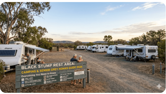
Black Stump Rest Area Camping — Senior Grey Nomad Guide 2026: Everything You Need to Know Before You Pull In
Black Stump Rest Area sits on the Barrier Highway (A32) between Coolabah and Nyngan in far-western New South Wales — a stretch of road that is long, flat, hot, and unforgiving if you are not prepared. For grey nomads travelling the inland route between Broken Hill and Dubbo in 2026, this rest area is one of the few places to pull over, stretch your legs, and — if you know the rules — camp legally overnight. But it is not a caravan park, it is not serviced, and it comes with limitations that every senior driver must understand before they commit to the turn-off. This guide covers every detail: the road conditions getting here, fuel distances in every direction, whether the road floods, what facilities actually exist on-site, the nearest hospital and dump point GPS, and how Black Stump Rest Area compares against paid and free alternatives nearby. If you are a grey nomad planning to travel this corridor in March 2026 or beyond, read this entire guide before you leave the bitumen.
📑 Table of Contents
- 1. Why Grey Nomads Stop at Black Stump Rest Area
- 2. The Barrier Highway — Road Conditions, Flooding and Fuel Distances
- 3. Your Options Side by Side — Black Stump vs Paid Alternatives
- 4. Black Stump Rest Area: Quick Facts and Facilities
- 5. Heat, Shade and Solo Safety — What Seniors Must Know
- 6. What Black Stump Rest Area Doesn’t Tell You
- 7. Van Life Savings Spots: Free and Low-Cost Camping Near the Barrier Highway
- 8. Nyngan Riverside Caravan Park — The Powered Alternative
- 9. Full Facilities Comparison
- 10. Dump Points and Free Water — Before, On-Site and After
- 11. The Barrier Highway Day Plan for Seniors
- 12. Senior Checklist: Black Stump Rest Area and Barrier Highway
- 13. What to Do in Nyngan: Your Senior Day Plan
- 14. GPS Coordinates and Postcodes — Save Every Stop
- 15. Frequently Asked Questions — Black Stump Rest Area for Grey Nomads
- 16. Quick-Reference Card, Booking CTAs and Affiliate Resources
1. Why Grey Nomads Stop at Black Stump Rest Area
The Barrier Highway between Nyngan and Broken Hill is one of the great inland corridors of Australian grey nomad travel, but it is also one of the loneliest. Between Coolabah and Nyngan — a roughly 80 km stretch — Black Stump Rest Area provides a legal, gazetted pull-off on the southern side of the highway. For seniors driving large rigs, it breaks up a long day’s drive and avoids the dangerous fatigue that causes so many highway accidents in outback NSW.
The rest area is located approximately 45 km west of Nyngan on the Barrier Highway (A32), in Bogan Shire, NSW 2825. The name “Black Stump” is famous across Australia — it is said to mark the boundary between the settled country and the outback. Whether this particular site is the “original” Black Stump is debated, but what matters to you as a grey nomad in 2026 is this: it is a flat, accessible, free overnight stop with basic facilities, on a sealed highway, in an area where your next options are a long way apart.
If you are researching grey nomad routes across Australia, the Barrier Highway is a key east–west connector, and knowing every rest area, fuel stop and water point along it is not optional — it is essential safety planning.
2. The Barrier Highway — Road Conditions, Flooding and Fuel Distances
This is the section that could save your trip — or your life. The Barrier Highway (A32) is fully sealed between Nyngan and Broken Hill, but “sealed” does not mean “worry-free.” Here is what you need to know in March 2026:
Road Surface and Condition
The road is a single carriageway, two lanes, with no centre barrier. The surface is bitumen and generally well maintained by Transport for NSW, but expect rough patches, edge damage, and occasional potholes — especially after heavy rain. Road trains use this highway. If you are towing a wide caravan, you will need to pull left and slow down when a road train passes. The turn-off into Black Stump Rest Area is on the left (south side) if you are heading west from Nyngan.
Does the Road Flood?
Is Any Part of the Road Unsealed?
No — the Barrier Highway from Nyngan to Broken Hill is fully sealed. The access into Black Stump Rest Area itself is a short sealed or hard-packed gravel pull-off directly adjacent to the highway. You do not need a 4WD. Standard caravans and motorhomes access it without difficulty in dry conditions. After rain, the gravel edges can become soft — park on the hardstand areas.
Fuel Station Distances — All Directions from Black Stump Rest Area
| Direction | Nearest Fuel | Distance | Notes |
|---|---|---|---|
| East (towards Nyngan) | Nyngan — multiple fuel stations (Caltex, BP) | ~45 km | Full range of fuels. Open 7 days. EFTPOS. Last reliable fuel heading west before Coolabah. |
| West (towards Coolabah/Bourke turn-off) | Coolabah Roadhouse | ~35 km | Limited hours. Check availability. Diesel and unleaded usually available. Cash recommended as backup. |
| Further West (towards Wilcannia) | Wilcannia | ~250 km from Black Stump | Long stretch. Fill up in Nyngan or Coolabah — do not rely on a single source. |
| North (towards Bourke) | Bourke (via Mitchell Highway from Coolabah) | ~160 km from Black Stump | Multiple fuel options in Bourke. Major resupply town. |
| South (towards Tottenham/Dubbo) | Nyngan first, then Tottenham (via Mitchell Hwy south) | Nyngan ~45 km, Tottenham ~120 km from Nyngan | If heading south towards Dubbo, fill in Nyngan. Dubbo is ~165 km south of Nyngan — full services. |
3. Your Two Main Options Side by Side — Black Stump Rest Area vs Nyngan Caravan Park
The biggest myth seniors hear online is: “Just free camp at Black Stump — it’s got everything you need.” It does not. Here is the honest comparison:
| Feature | Black Stump Rest Area (Free) | Nyngan Riverside Caravan Park (Paid) |
|---|---|---|
| Cost | Free — no booking, no fee | Powered sites from ~$35–$45/night (2026 rates — call to confirm) |
| 240V Power | ❌ No power | ✅ Powered sites available |
| Toilets | ⚠️ Pit toilet / long-drop only (condition varies) | ✅ Flush toilets and hot showers |
| Dump Point | ❌ No dump point on-site | ✅ Dump point on-site |
| Potable Water | ❌ No potable water — BYO | ✅ Town water available |
| Shade / Trees | ⚠️ Limited native shade — some trees but not guaranteed over your rig | ✅ Established shade trees along the river |
| Phone Signal | ⚠️ Patchy Telstra — no Optus | ✅ Good Telstra in town |
| Dogs | ✅ Dogs allowed — on lead | ✅ Pet-friendly (confirm on booking) |
| Nearest Hospital | Nyngan Multi Purpose Health Service — ~45 km east | Nyngan Multi Purpose Health Service — ~2 km |
| Senior Recommendation | Suitable for one-night driver-fatigue stop. Not ideal for extended stays for seniors with medical needs. | ← Senior Recommended — power, water, dump point, medical proximity |
4. Black Stump Rest Area: Quick Facts, Full Address and Facilities
Black Stump Rest Area is managed by Bogan Shire Council and Transport for NSW as a designated driver rest area on the Barrier Highway. Overnight stays are permitted — this is a legal free camp. No permit is required. No fees apply. There is no booking system.
| Quick Fact | Detail |
|---|---|
| Official Name | Black Stump Rest Area |
| Full Address | Barrier Highway (A32), approximately 45 km west of Nyngan, NSW 2825 |
| GPS Coordinates | GPS: -31.5530, 147.0690 |
| Postcode | 2825 |
| Cost | Free — no permit, no booking required |
| Overnight Stay | ✅ Permitted (driver fatigue rest area — overnight stays allowed) |
| Maximum Stay | Typically 24–48 hours (check signage on-site for current limits) |
| Toilets | Pit toilet / long-drop (condition varies — BYO toilet paper recommended) |
| Potable Water | ❌ No — BYO water |
| Power (240V) | ❌ No |
| Dump Point | ❌ No — nearest dump point in Nyngan (~45 km east) |
| Dogs | ✅ Allowed — on lead |
| Surface | Hard-packed gravel/dirt with some sealed areas. Flat. Suitable for caravans and motorhomes. |
| Drive-Through Access | ✅ Yes — pull-through layout. No reversing needed for most rigs. |
| Picnic Tables / Shelter | Yes — picnic tables and some shade shelter structures |
| Rubbish Bins | ⚠️ Sometimes available — council serviced. Do not rely on them. Carry your own rubbish out. |
| Phone Coverage | Telstra: Patchy (external antenna helps). Optus: Unlikely. Public WiFi: ❌ None |
| Nearest Hospital | Nyngan Multi Purpose Health Service, 28 Pangee Street, Nyngan NSW 2825. GPS: -31.5600, 147.1940. Phone: 02 6832 1409. Distance: ~45 km east. |
| Managed By | Bogan Shire Council / Transport for NSW |
| Coordinate Source | WikiCamps AU, verified against NSW rest area listings |
5. Heat, Shade and Solo Safety — What Seniors Must Know About Black Stump Rest Area
In March 2026, temperatures in the Nyngan–Coolabah corridor regularly exceed 38°C. The Bureau of Meteorology records for this area show March can produce heatwave conditions with consecutive days above 40°C. At Black Stump Rest Area, there is limited natural shade. Some scattered native trees provide patchy cover, but you cannot guarantee your caravan or motorhome will be shaded — especially in the afternoon when the sun is on the western side.
Solo Traveller Safety
Black Stump Rest Area is adjacent to the highway. You will hear road trains passing at night. The site is not fenced and is not lit. For solo travellers — especially solo women — this means: park close to other travellers if any are present, keep your rig locked, and have a PLB (Personal Locator Beacon) registered with AMSA accessible inside your vehicle. Phone signal is unreliable. If something goes wrong at 2 am, your PLB is your lifeline. Read more about grey nomad security and caravan theft prevention before heading into remote areas.
6. What Black Stump Rest Area Doesn’t Tell You Online
Most online listings for Black Stump Rest Area give you the GPS and a brief “toilet, tables, free camp” summary. Here are the details that matter to seniors and that you won’t find on most apps:
- Toilet condition varies wildly by season: The pit toilet is serviced by council, but in peak travel season (April–September), it gets heavy use. By late March, it can be in poor shape. BYO toilet paper and hand sanitiser are essential. If you are mobility-limited, the pit toilet may not be suitable — consider using your own onboard facilities.
- Road noise is real: Road trains pass at all hours. If you are a light sleeper, earplugs are not optional. The site is directly adjacent to the highway — not set back hundreds of metres like some rest areas.
- Flies in March are extreme: The Barrier Highway corridor in late summer produces some of the worst bush flies in NSW. A fly net for your head and a good screen door on your caravan are essential, not luxury items.
- Other travellers may include non-campers: Because this is a highway rest area, you will share it with truck drivers on mandated fatigue breaks, grey nomads, and occasionally people sleeping rough. Most encounters are perfectly fine — but be aware of your surroundings, especially if arriving after dark.
- No mobile phone boost tower nearby: Even with an external Telstra antenna on your caravan, signal is marginal. Download offline maps, save all GPS waypoints, and have emergency numbers written on paper in your glovebox — not just on your phone.
7. Van Life Savings Spots: Free and Low-Cost Camping Near the Barrier Highway
Black Stump Rest Area is not the only free option along this corridor. Use the Van Life Savings Spots app to search for alternatives in real time. Here are example AI queries tailored to this location that you can paste directly into the app:
- “Free overnight camping within 100 km of Nyngan NSW with toilets”
- “Rest areas on Barrier Highway with dump points”
- “Pet-friendly free camps near Coolabah NSW”
- “Powered caravan sites under $40 near Nyngan”
COPY PROMPT ➔ ASK AI ➔ SAVE TO FORM ➔ ADD SPOT PIN ➔ GET DIRECTIONS
📍 Interactive map — find free camps, rest areas and overnight stops. Enable location for best results.
Below are verified free and low-cost camping options near Black Stump Rest Area for 2026:
| Site Name | Cost | Address / Location | GPS | Distance from Black Stump | Senior Verdict |
|---|---|---|---|---|---|
| Black Stump Rest Area | Free | Barrier Highway (A32), ~45 km W of Nyngan, NSW 2825 | -31.5530, 147.0690 | On-site | Good one-night driver-fatigue stop. No power, no water. Fine for self-contained rigs. |
| Coolabah Rest Area | Free | Barrier Highway, Coolabah, NSW 2831 | -31.4210, 146.8470 | ~35 km west | Basic. Toilets reported. Close to Coolabah Roadhouse for fuel. Similar conditions to Black Stump. |
| Nyngan Rotary Park / Riverside Free Area | Free (check signage for current rules — council managed) | Bogan River, near Pangee Street, Nyngan, NSW 2825 | -31.5610, 147.1900 | ~45 km east | In town. Toilets nearby. Close to shops, hospital, fuel. Better choice for seniors needing services. Check current overnight rules with Bogan Shire Council. |
| Hermidale Rest Area | Free | Barrier Highway, Hermidale, NSW 2831 | -31.4360, 146.6320 | ~60 km west | Small rest area. Very basic. Quiet. For self-contained rigs only. Check availability of toilet on arrival. |
8. Nyngan Riverside Caravan Park — The Powered Alternative for Grey Nomads
If you are a senior who needs power for a CPAP machine, wants hot showers, a dump point, and proximity to a hospital — the smart move is to drive the 45 km to Nyngan and stay at a powered caravan park. Nyngan Riverside Caravan Park is the primary option:
| Detail | Information |
|---|---|
| Name | Nyngan Riverside Caravan Park |
| Address | Barrier Highway (Pangee Street), Nyngan, NSW 2825 |
| GPS | GPS: -31.5620, 147.1870 |
| Phone | 02 6832 1850 (call to confirm current rates and availability) |
| Facilities | Powered sites, flush toilets, hot showers, dump point, laundry, camp kitchen, BBQ, town water, shaded sites along Bogan River |
| Pets | Pet-friendly — confirm on booking |
| Senior Notes | Close to hospital (~2 km), fuel, supermarket. Shaded riverside sites are the best for hot weather. Ask for a drive-through site if you have a large rig. For how long you can stay, see our guide on how long you can stay in a caravan park in Australia. |
9. Full Facilities Comparison — Black Stump vs Nyngan Riverside vs Coolabah Rest Area
| Facility | Black Stump Rest Area | Nyngan Riverside Caravan Park | Coolabah Rest Area |
|---|---|---|---|
| 240V Power | ❌ | ✅ | ❌ |
| Flush Toilets / Showers | ❌ Pit toilet only | ✅ Flush toilets, hot showers | ❌ Pit toilet only |
| Dump Point | ❌ | ✅ | ❌ |
| Potable Water | ❌ | ✅ | ❌ |
| Dogs Allowed | ✅ | ✅ (confirm) | ✅ |
| Phone Coverage | ⚠️ Patchy Telstra | ✅ Good Telstra in town | ⚠️ Patchy |
| Medical Proximity | 45 km to Nyngan Hospital | ~2 km to Nyngan Hospital | ~80 km to Nyngan Hospital |
| Wi-Fi | ❌ | ⚠️ Check with park | ❌ |
| Shade | ⚠️ Limited | ✅ Riverside shade trees | ⚠️ Limited |
| Senior Overall Rating | ⭐⭐⭐ — Acceptable one-night stop | ⭐⭐⭐⭐ — ← Senior Recommended | ⭐⭐ — Very basic |
10. Dump Points and Free Water — Before, On-Site and After Black Stump Rest Area
There is no dump point and no potable water at Black Stump Rest Area. This is the most critical planning point for grey nomads with onboard grey/black water tanks. You must plan your dump and water fill before and after stopping here.
🗑️ Dump Point Table
| Location | Type | Address | GPS | Distance from Black Stump | Notes |
|---|---|---|---|---|---|
| Black Stump Rest Area | On-site | Barrier Hwy, NSW 2825 | -31.5530, 147.0690 | — | ❌ No dump point on-site |
| 🗑️ Nyngan Dump Point (before/after — east) | Before / After | Nyngan Riverside Caravan Park, Pangee Street, Nyngan, NSW 2825 | -31.5620, 147.1870 | ~45 km east | Dump point at the caravan park. May be accessible to non-guests — call ahead: 02 6832 1850. Also check the Nyngan public dump point near the showground area. |
| 🗑️ Nyngan Showground Dump Point | Before / After | Nyngan Showground, Cobar Street, Nyngan, NSW 2825 | -31.5570, 147.1950 | ~45 km east | Public dump point — free. Verify access and condition on arrival. Council-managed. |
| 🗑️ Cobar Dump Point (after — further west) | After (heading west) | Cobar Caravan Park, Barrier Highway, Cobar, NSW 2835 | -31.4960, 145.8390 | ~170 km west | Dump point available. Cobar is a major resupply town with fuel, supermarket, hospital. |
💧 Free Water Table
| Location | Type | Address | GPS | Distance from Black Stump | Notes |
|---|---|---|---|---|---|
| Black Stump Rest Area | On-site | Barrier Hwy, NSW 2825 | -31.5530, 147.0690 | — | ❌ No potable water on-site |
| 💧 Nyngan — Town Water | Before / After | Nyngan Riverside Caravan Park or public tap (check with council), Nyngan, NSW 2825 | -31.5620, 147.1870 | ~45 km east | Fill tanks in Nyngan before heading west. Town water. Use a food-grade hose. |
| 💧 Cobar — Town Water | After (heading west) | Cobar Caravan Park, Barrier Highway, Cobar, NSW 2835 | -31.4960, 145.8390 | ~170 km west | Potable water available. Fill up here if continuing west towards Wilcannia. |
11. The Barrier Highway Day Plan for Seniors — Nyngan to Black Stump and Beyond
If you are heading west from Nyngan and plan to use Black Stump Rest Area as your overnight stop, here is a senior-friendly timed plan for a March 2026 day:
| Time | Activity | Location / GPS |
|---|---|---|
| 7:00 am | Fuel up, fill water tanks, check tyre pressures. Dump tanks if needed. | Nyngan fuel stations / caravan park — GPS: -31.5600, 147.1940 |
| 7:30 am | Depart Nyngan heading west on Barrier Highway (A32) | Barrier Highway west |
| 8:00 am | Arrive Black Stump Rest Area (~45 km). Walk around, check facilities, stretch. | Black Stump Rest Area — GPS: -31.5530, 147.0690 |
| 8:30 am | Decision point: Continue west to Coolabah (~35 km further) or set up for the day if staying. | — |
| By 10:00 am | If continuing, aim to be set up at your next stop before the heat peaks. In March, temperatures above 35°C are common by midday. | — |
| 4:00 pm | If arriving late in the day for an overnight stop at Black Stump — set up awning on western side, walk dog, prepare for an early departure the next morning. | Black Stump Rest Area — GPS: -31.5530, 147.0690 |
| 6:00 am (next day) | Depart Black Stump before heat builds. Drive to Coolabah for fuel check, then continue west towards Cobar or north towards Bourke. | — |
12. Senior Checklist: Black Stump Rest Area and Barrier Highway
Print this checklist or screenshot it to your phone before you leave WiFi coverage. Every item is specific to this location and this route in 2026.
| Item | Why It Matters for the Barrier Highway | ✓ |
|---|---|---|
| Travel insurance with medical evacuation cover | Nearest major hospital (Dubbo Base Hospital) is 165+ km from Nyngan. RFDS may be needed for serious emergencies. Evacuation cover is essential. | ☐ |
| PLB registered with AMSA | No reliable phone signal at Black Stump Rest Area. A registered PLB (beacons.amsa.gov.au) is the only reliable emergency signal in this area. | ☐ |
| 2-week prescription medication supply | Nyngan pharmacy has limited stock. Specialist medications unavailable. Stock up before departing from a major centre (Dubbo or Orange). | ☐ |
| Medicare card + medication list in waterproof pouch | Keep accessible in the cabin — not packed in the caravan. A printed medication list saves critical time at Nyngan Health Service. | ☐ |
| Full water tanks (minimum 100L drinking water) | No water at Black Stump. Fill in Nyngan. 4L per person per day minimum for drinking in March heat. | ☐ |
| Full fuel tank + 20L jerry can | Coolabah Roadhouse may be closed. Next reliable fuel west is Cobar (~170 km from Black Stump). | ☐ |
| Sunscreen SPF 50+ and wide-brim hat | UV index extreme in March. No shade guaranteed at rest area. Cover up even for short walks. | ☐ |
| Offline maps downloaded (Google Maps / Hema) | No data signal at Black Stump. Download offline maps covering Nyngan to Cobar corridor while in WiFi. | ☐ |
| CPAP lithium battery (fully charged) | No power at Black Stump. If you need CPAP, either have a lithium battery or drive to Nyngan for a powered site. | ☐ |
| Emergency numbers on paper in glovebox | Write down: 000, Nyngan Hospital 02 6832 1409, RFDS 1800 625 800, roadside assist number. Phone may be flat or have no signal. | ☐ |
| Dog water, lead and tie-out | Dogs allowed at Black Stump — on lead. Carry extra water for your dog. No off-lead areas. | ☐ |
| BYO toilet paper and hand sanitiser | Pit toilet at Black Stump may have no paper. Always carry your own. | ☐ |
| 🗑️ Dump point GPS saved — Nyngan (before) | Nearest dump point: Nyngan — GPS: -31.5620, 147.1870. Dump before departing west. | ☐ |
| 🗑️ Dump point GPS saved — Cobar (after) | Next dump point heading west: Cobar — GPS: -31.4960, 145.8390. ~170 km from Black Stump. | ☐ |
| 💧 Water top-up location GPS saved — Nyngan | Fill tanks in Nyngan — GPS: -31.5620, 147.1870. No water between Nyngan and Cobar. | ☐ |
| Live Traffic NSW checked (livetraffic.com) | Check for road closures before departing. The Barrier Highway floods. Do not drive into floodwater. | ☐ |
13. What to Do in Nyngan: Your Senior Day Plan
Nyngan is the nearest town to Black Stump Rest Area with services, and it deserves a stop — not just a fuel fill. Here are senior-friendly activities:
| Activity | Address / Location | GPS | Senior Notes |
|---|---|---|---|
| Nyngan Museum | Pangee Street, Nyngan, NSW 2825 | -31.5610, 147.1930 | Local history including the 1990 flood. Air-conditioned. Flat access. Gold coin donation. Check opening hours. |
| Bogan River Walk | Along the Bogan River, central Nyngan, NSW 2825 | -31.5600, 147.1900 | Flat, shaded walking path along the river. Suitable for mobility-limited walkers. Early morning only in March heat. |
| 1990 Flood Memorial | Central Nyngan near the river, NSW 2825 | -31.5590, 147.1920 | Memorial to the devastating 1990 Nyngan flood. Short walk from main street. Informative panels. |
| Big Bogan (public art) | Barrier Highway entry, Nyngan, NSW 2825 | -31.5570, 147.1980 | Photo opportunity. Quick stop. Flat access from parking area. |
| Nyngan Swimming Pool | Cobar Street, Nyngan, NSW 2825 | -31.5560, 147.1960 | Public pool — essential in March heat. Check opening hours and season dates. Small entry fee. Shade available. |
| Nyngan RSL Club (air-conditioned lunch) | Pangee Street, Nyngan, NSW 2825 | -31.5600, 147.1940 | Air-conditioned dining. Affordable seniors meals. Good place to cool down in the afternoon heat. Check opening hours. |
14. GPS Coordinates and Postcodes — Save Every Stop Before You Leave WiFi
Copy every GPS coordinate below to your navigation app or the Van Life Savings Spots app while you still have WiFi or phone signal. Once you are west of Nyngan, reliable data coverage disappears. Save these now.
| Stop | Full Address + Postcode | GPS (Copy to App) |
|---|---|---|
| Black Stump Rest Area | Barrier Highway (A32), ~45 km W of Nyngan, NSW 2825 | -31.5530, 147.0690 |
| Coolabah Rest Area | Barrier Highway, Coolabah, NSW 2831 | -31.4210, 146.8470 |
| Nyngan Riverside Caravan Park | Pangee Street, Nyngan, NSW 2825 | -31.5620, 147.1870 |
| Nyngan Rotary Park / Riverside Free Area | Near Pangee Street, Nyngan, NSW 2825 | -31.5610, 147.1900 |
| Hermidale Rest Area | Barrier Highway, Hermidale, NSW 2831 | -31.4360, 146.6320 |
| 🏥 Nyngan Multi Purpose Health Service | 28 Pangee Street, Nyngan, NSW 2825 | -31.5600, 147.1940 — Phone: 02 6832 1409 |
| 🏥 Dubbo Base Hospital (major hospital) | Myall Street, Dubbo, NSW 2830 | -32.2490, 148.6130 — Phone: 02 6885 0900 |
| 🏥 Cobar Health Service | Lewis Street, Cobar, NSW 2835 | -31.4940, 145.8360 — Phone: 02 6836 0222 |
| 🗑️ Nyngan Dump Point (Caravan Park) | Pangee Street, Nyngan, NSW 2825 | -31.5620, 147.1870 |
| 🗑️ Nyngan Dump Point (Showground) | Cobar Street, Nyngan, NSW 2825 | -31.5570, 147.1950 |
| 🗑️ Cobar Dump Point | Cobar Caravan Park, Barrier Highway, Cobar, NSW 2835 | -31.4960, 145.8390 |
| 💧 Water — Nyngan | Nyngan Riverside Caravan Park, Pangee Street, Nyngan, NSW 2825 | -31.5620, 147.1870 |
| 💧 Water — Cobar | Cobar Caravan Park, Barrier Highway, Cobar, NSW 2835 | -31.4960, 145.8390 |
| ⛽ Nyngan Fuel | Barrier Highway / Mitchell Highway, Nyngan, NSW 2825 | -31.5580, 147.1950 |
| ⛽ Coolabah Roadhouse | Barrier Highway, Coolabah, NSW 2831 | -31.4200, 146.8460 |
| Nyngan Museum | Pangee Street, Nyngan, NSW 2825 | -31.5610, 147.1930 |
| Nyngan Swimming Pool | Cobar Street, Nyngan, NSW 2825 | -31.5560, 147.1960 |
| Nyngan RSL Club | Pangee Street, Nyngan, NSW 2825 | -31.5600, 147.1940 |
15. Frequently Asked Questions — Black Stump Rest Area for Grey Nomads
Can you camp overnight at Black Stump Rest Area NSW?
Yes. Black Stump Rest Area on the Barrier Highway (A32), approximately 45 km west of Nyngan, NSW 2825, is a gazetted driver rest area where overnight stays are permitted. There is no fee and no booking required. Check on-site signage for any current time limits (typically 24–48 hours). GPS: -31.5530, 147.0690.
Is there a toilet at Black Stump Rest Area?
Yes — a pit toilet / long-drop is provided. Condition varies by season and use. BYO toilet paper and hand sanitiser. There are no flush toilets or showers. If you need accessible or flush toilet facilities, Nyngan Riverside Caravan Park (~45 km east) is the nearest option.
Is there water at Black Stump Rest Area?
No. There is no potable water at Black Stump Rest Area. Fill your water tanks in Nyngan before heading west. Carry a minimum of 4 litres per person per day for drinking in March heat.
Does the Barrier Highway between Nyngan and Coolabah flood?
Yes. The Barrier Highway passes through flat floodplain country and can be cut for days or weeks during major rain events. Always check Live Traffic NSW (livetraffic.com) before departing. Never drive through floodwater. In March 2026, late-summer storms are a real possibility.
Where is the nearest dump point to Black Stump Rest Area?
The nearest dump point is in Nyngan, approximately 45 km east. Options include Nyngan Riverside Caravan Park (GPS: -31.5620, 147.1870) and the Nyngan Showground public dump point (GPS: -31.5570, 147.1950). Heading west, the next dump point is in Cobar (~170 km, GPS: -31.4960, 145.8390).
Where is the nearest hospital to Black Stump Rest Area?
Nyngan Multi Purpose Health Service, 28 Pangee Street, Nyngan, NSW 2825. GPS: -31.5600, 147.1940. Phone: 02 6832 1409. Distance: approximately 45 km east. For major emergencies, Dubbo Base Hospital is 165+ km further east (GPS: -32.2490, 148.6130, phone: 02 6885 0900). RFDS (Royal Flying Doctor Service) can be contacted on 1800 625 800.
Is Black Stump Rest Area suitable for large caravans?
Yes. The rest area has a pull-through layout and flat, hard-packed surface suitable for large caravans and motorhomes. No reversing is required for most rigs. The access is directly off the sealed Barrier Highway.
Is there phone signal at Black Stump Rest Area?
Telstra signal is patchy at best. An external antenna may improve reception slightly. Optus coverage is unlikely. There is no public WiFi. Save all maps, GPS coordinates, and emergency numbers offline before leaving Nyngan. A PLB (Personal Locator Beacon) registered with AMSA is strongly recommended for this stretch of highway.
Do I need a permit to camp at Black Stump Rest Area in 2026?
No permit is required. No fee applies. Black Stump Rest Area is a free, gazetted driver rest area managed by Bogan Shire Council and Transport for NSW. Simply pull in and set up. Always check the on-site signage for any rule changes — councils occasionally update time limits or conditions.
Are dogs allowed at Black Stump Rest Area?
Yes. Dogs are allowed at Black Stump Rest Area — keep them on a lead. Carry extra water for your dog in the March heat. There are no off-lead exercise areas.
16. Quick-Reference Card — Black Stump Rest Area 2026
Screenshot this card to your phone — it contains everything you need at a glance:
| Detail | Information |
|---|---|
| Name | Black Stump Rest Area |
| Location | Barrier Highway (A32), ~45 km west of Nyngan, NSW 2825 |
| GPS | -31.5530, 147.0690 |
| Cost | Free — no permit, no booking |
| Toilets | Pit toilet (BYO paper) |
| Water | ❌ No — BYO |
| Power | ❌ No |
| Dump Point | ❌ No — nearest Nyngan 45 km east |
| Dogs | ✅ On lead |
| Nearest Fuel East | Nyngan — 45 km |
| Nearest Fuel West | Coolabah Roadhouse — 35 km (check hours) |
| Nearest Hospital | Nyngan — 45 km — 02 6832 1409 |
| RFDS | 1800 625 800 |
| Emergency | 000 |
| Phone Signal | Telstra patchy — no Optus — no WiFi |
| Road Floods? | Yes — check livetraffic.com before departing |
Address: Pangee Street, Nyngan, NSW 2825
GPS: -31.5620, 147.1870
Phone: 02 6832 1850
What to ask: “Do you have a shaded, powered, drive-through site for [your dates]? We have a [X]-foot rig. We need power for CPAP. Is the dump point accessible? Are dogs allowed?”
Save the GPS for both Black Stump Rest Area and Nyngan Riverside to your Van Life Savings Spots app before you leave WiFi.
Disclaimer: Black Stump Rest Area information in this article is current as of March 2026 based on publicly available sources including WikiCamps AU, NSW rest area listings, and community reports. Facilities, rules, road conditions and phone numbers can change without notice. Always verify current conditions on-site, check Live Traffic NSW for road closures, and confirm details by phone before travelling. GPS coordinates are approximate and sourced from publicly available databases — always cross-reference with your own navigation device. This article contains affiliate links. As an affiliate, the author earns from qualifying purchases at no extra cost to you. This website is not affiliated with Bogan Shire Council, Transport for NSW, or any caravan park mentioned. Always carry adequate water, fuel, medication and emergency communication devices when travelling in remote NSW.
Free campsites and powered sites fill fast during school holidays and peak season. If your preferred site is already gone, search remaining accommodation options below to explore the region.
Accommodation and flight search powered by Expedia. Booking through this search supports this website at no extra cost to you. As an affiliate, I earn from qualifying purchases at no extra cost to you.

As an affiliate, I earn from qualifying purchases at no extra cost to you.