Home › Queensland Rest Areas › Square Bush Rest Area
Square Bush Rest Area — Complete Senior Grey Nomad Guide 2026
Last updated: June 2026 | Burnett Highway, QLD | Reading time: approx. 18 min
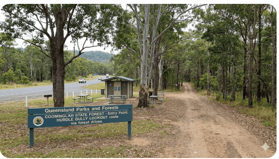
If you’re driving the Burnett Highway between Monto and Biloela in central Queensland, Square Bush Rest Area is one of those quiet, easy-to-miss stops that grey nomads and road-trippers genuinely need to know about — and not just for a toilet break. It’s the official gateway into Coominglah State Forest, the last point with toilet facilities before the forest tracks begin, and an important fuel-and-water planning checkpoint for anyone heading deeper into this remote stretch of inland Queensland.
This guide covers everything a senior traveller or grey nomad needs in 2026: GPS coordinates, road conditions, flood risk, fuel distances, overnight rules, accessibility, wildlife, nearby free camps, and honest notes about what other websites don’t tell you.
📋 Table of Contents
- Why Grey Nomads Stop at Square Bush Rest Area
- Free Camping — Know the Limits for Seniors
- Your Two Main Options Side by Side
- Quick Facts and Key Details 2026
- How to Get to Square Bush Rest Area + GPS
- Road Conditions, Flooding and Unsealed Sections
- Heat and Remoteness — Seniors
- Wildlife — Birds, Reptiles and What to Watch For
- What Other Websites Don’t Tell You
- Best Time to Visit — Month-by-Month Breakdown
- Free and Low-Cost Camping Nearby
- Dump Points Near Square Bush Rest Area
- Free Water Sources Near Monto
- Fuel Stops Along the Burnett Highway
- Showground or Caravan Park — Paid Alternatives
- Full Facilities Comparison Table
- Rates — All Options Near Square Bush Rest Area 2026
- Senior Checklist — Safety On and Off the Road
- What to Do Near Square Bush Rest Area — Senior Activity Guide
- 🗺️ Vanlife Savings Spots GPS Coordinates and Postcodes
- Phone Signal and Emergency Communications
- Campfires, Cooking Restrictions and Food Purchases
- Pets at Square Bush Rest Area
- Accessibility for Seniors with Mobility Limitations
- Camping Permits, Fees, Etiquette and Waste Management
- Emergency Scenarios — What to Do
- Packing List for This Section of Highway
- 5 Rest Areas Near Square Bush / Burnett Highway
- Reviews — What Grey Nomads Say
- Frequently Asked Questions
- Quick-Reference Card
- Disclaimer
1. Why Grey Nomads Stop at Square Bush Rest Area
Square Bush Rest Area sits on the Burnett Highway approximately 19 km north-west of Monto, Queensland, on the road heading toward Biloela (roughly 100 km further north-west). For travellers on the long inland route that connects the Sunshine Coast hinterland and Wide Bay region with central Queensland, it’s one of the few formal stopping points in an otherwise remote, sparse corridor.
Grey nomads stop here for three main reasons:
- 🚽 It’s the only toilet facility in this section of Coominglah State Forest and the last one before the forest drive begins.
- 🌳 Gateway to the Hurdle Gully Lookout drive — one of Queensland’s underrated scenic 4WD day trips through eucalypt forest and dry rainforest, with panoramic views over Three Moon Creek Valley.
- ☕ A sensible rest break on a long, hot, monotonous inland drive. The shade and picnic tables here make it far more comfortable than pulling over on the highway shoulder.
2. Free Camping — Know the Limits for Seniors
Square Bush Rest Area is NOT a campground. Overnight stays are not permitted here. It is a roadside rest area managed under Queensland Transport and Main Roads guidelines, which means it’s intended for short rest stops only — typically no more than a few hours.
This is one of the most important things to get right before you park up for the night. Queensland rest areas along state highways carry fines for unauthorised overnight camping, and unlike some rest areas in other states, there are no 20-hour informal allowances posted here.
This is a day-use rest stop only. Camping is also not permitted in Coominglah State Forest. If you plan to camp, you must move on to Kalpowar State Forest (north of Monto) or Tolderodden Conservation Park (west of Eidsvold). See Section 11 for full details.
3. Your Two Main Options Side by Side
| Option | Best For | Cost | Overnight? |
|---|---|---|---|
| Square Bush Rest Area | Toilet break, picnic, day stop, forest drive entry point | Free | ❌ No |
| Kalpowar State Forest (free camp) | Overnight free camping, basic bush camp | Free | ✅ Yes |
| Monto Showground / Caravan Park | Powered sites, showers, laundry, seniors comfort | ~$20–$35/night | ✅ Yes |
| Tolderodden Conservation Park | Bush camping west of Eidsvold | Free | ✅ Yes (basic) |
4. Quick Facts and Key Details 2026
| Detail | Information |
|---|---|
| Location | Burnett Highway, ~19 km NW of Monto, QLD |
| Nearest town | Monto (19 km SE) |
| Postcode | 4630 (Monto area) |
| GPS Coordinates | Approx. -24.7650, 150.9120 (publicly available estimate — verify with Google Maps) |
| Road type (access) | Sealed — Burnett Highway to the rest area entrance |
| Toilets | Yes — this is the ONLY toilet in the area before the forest drive |
| Picnic tables | Yes |
| Drinking water | ❌ Not available — carry your own |
| Overnight camping | ❌ Not permitted |
| Managed by | Queensland Transport and Main Roads / Forestry |
| Mobile reception | Limited to none beyond the highway |
| 4WD access to forest | Begins here — Kington Road into Coominglah |
| Entry fee (rest area) | Free |
5. How to Get to Square Bush Rest Area + GPS
From Monto (heading north-west toward Biloela)
Take the Burnett Highway north-west out of Monto. After approximately 19 km, look for the signed rest area and turn-off on the left side of the highway. The turnoff for Square Bush Rest Area and the Hurdle Gully Lookout / Coominglah State Forest drive is signposted — do not miss it, as the next toilet is over 30 km away.
From Biloela (heading south-east toward Monto)
Take the Burnett Highway south-east from Biloela. Monto is approximately 100 km from Biloela. Square Bush Rest Area will appear on the right side of the highway approximately 19 km before Monto.
GPS Coordinates
Square Bush Rest Area (estimated): -24.7650, 150.9120
Note: These are publicly available approximate coordinates based on the described location (~19 km NW of Monto on the Burnett Highway). Always cross-reference with Google Maps or your GPS unit before departing. Search “Square Bush Rest Area Burnett Highway” in Google Maps for the pinned location.
Distances to Key Towns
| Town / Location | Direction | Approx. Distance | Road Type |
|---|---|---|---|
| Monto | South-East | ~19 km | Sealed (Burnett Hwy) |
| Biloela | North-West | ~100 km | Sealed (Burnett Hwy) |
| Eidsvold | South-East (via Monto) | ~68 km | Sealed |
| Rockhampton | North (via Biloela) | ~250 km | Sealed |
| Gayndah | South-East (via Burnett Hwy) | ~115 km | Sealed |
| Cania Gorge NP | East (via Monto/Cedar Creek Rd) | ~45 km | Sealed + some gravel |
6. Road Conditions, Flooding and Unsealed Sections
This is one of the most critical sections of this guide — particularly for grey nomads towing caravans or driving larger rigs.
The Burnett Highway (Sealed Access to the Rest Area)
The Burnett Highway to the rest area turnoff is fully sealed and generally in good condition. However, like many Queensland inland highways, it is subject to:
- 🌊 Flooding — Three Moon Creek and other waterways in this region flood rapidly during heavy rain, and sections of the Burnett Highway have been cut by floodwaters historically. Always check the Queensland TMR road conditions website before driving (conditions.transport.qld.gov.au).
- 🐾 Wildlife crossings at dawn and dusk — kangaroos, wallabies and cattle on unfenced sections.
- 🚚 Road trains — heavy vehicle traffic is common on the Burnett Highway. Keep left and allow extra passing distance.
Coominglah State Forest Roads (Unsealed — Beyond the Rest Area)
The roads beyond Square Bush Rest Area into Coominglah State Forest are unsealed, steep and extremely hazardous in wet weather. The weathered sandstone and clay soils become dangerously slippery after even a light shower. Vehicles have slid off the road and become bogged on soft shoulders. Help can be hours away. Mobile reception is virtually non-existent.
Here is what the Queensland Government’s own guidance states about these roads:
- 4WD vehicles only — high clearance and differential locking capability required on the 4WD-rated tracks.
- No caravans, 2WD campervans, mobile homes or conventional camper trailers — clearance and slippery conditions make these impossible safely.
- Steep sections must not be attempted in wet weather — braking may be ineffective on clay surfaces.
- Some tracks have fallen trees or deep washouts — expect obstacles.
- Gate rules apply: leave gates as you find them. Never force a locked gate.
Does the Road Flood?
Yes — both the Burnett Highway and the forest tracks can flood. The region sits within the Burnett River catchment, and Three Moon Creek (visible from the Hurdle Gully Lookout) rises quickly in heavy rain events. The period from November through March (wet season / cyclone season) carries the highest flood risk. If you are travelling in this period:
- Check road conditions: conditions.transport.qld.gov.au
- Never drive through floodwater — “If it’s flooded, forget it.”
- Factor in a 24–48 hour delay contingency in your travel schedule.
7. Heat and Remoteness — Senior Safety
Central Queensland can be brutally hot between October and April. Monto and the surrounding region regularly see temperatures exceed 38°C–42°C in summer. At Square Bush Rest Area and anywhere on the Coominglah forest drives, there is no emergency infrastructure — no phone signal, no passing traffic on the forest tracks, no water taps, and no shade beyond what the eucalypt canopy provides.
- 🌡️ Always carry a minimum of 5 litres of drinking water per person per day — more in summer.
- 🕗 Plan forest drives early morning (before 9am) to avoid peak heat.
- 🚗 Never leave pets or passengers in parked vehicles in this heat.
- 💊 Seniors on blood pressure or heart medications should check with their doctor before undertaking strenuous activity in this climate.
- 🛑 If someone in your party shows signs of heat stroke — confusion, hot dry skin, no sweating — this is a medical emergency. Move them to shade, cool with water, and activate your PLB or satellite communicator immediately.
Before driving into Coominglah State Forest beyond Square Bush Rest Area, tell a responsible person your route and expected return time. Ask them to contact Queensland Police (131 444) if you have not made contact by an agreed time. Carry a PLB (Personal Locator Beacon) or Garmin inReach satellite communicator as a minimum.
8. Wildlife — Birds, Reptiles and What to Watch For
Coominglah State Forest surrounding Square Bush Rest Area supports an extraordinary 650+ plant species and 440+ animal species. Even a brief rest stop here can reward patient observers with remarkable wildlife sightings.
Birds
- 🦅 Wedge-tailed Eagles — commonly seen soaring over the forest canopy. Australia’s largest bird of prey.
- 🦜 Glossy Black-Cockatoos — uncommon and special. They feed almost exclusively on allocasuarina seeds; look for mangled seed pod remains (called “orts”) on the ground under trees as a sign of their presence.
- 🦋 The Hurdle Gully area is also a butterfly hotspot — many species have been recorded in the warmer months.
- 🦆 Various honeyeaters, rosellas, kookaburras and raptors are common throughout the area.
Mammals and Reptiles
- 🦘 Eastern Grey Kangaroos — common in the grassy understorey, especially at the Hurdle Gully Lookout clearing. High density at dawn and dusk — drive with care.
- 🐾 Yellow-bellied Gliders — large, noisy, gregarious gliders active at night in spotted gums. A spectacular sighting if you’re camped legally nearby.
- 🦎 Golden-tailed Gecko (Strophurus taenicauda) — a tiny, beautiful gecko that hunts insects under bark and leaf litter at night.
- 🐍 Snakes — eastern brown and taipan country. Always watch where you step, especially around picnic tables and toilet facilities. Wear closed shoes.
Threatened Species
The Hurdle Gully Scrub — accessible via the forest drive starting at Square Bush Rest Area — is an extreme form of dry seasonal subtropical rainforest and supports 18 known threatened species. This makes the Coominglah corridor genuinely significant for conservation and a must-visit for wildlife-focused grey nomads.
9. What Other Websites Don’t Tell You
Most travel and camping websites give Square Bush Rest Area a single sentence: “Rest area with toilets on the Burnett Highway.” Here is what they consistently leave out:
- 🚽 It’s the ONLY toilet for a very long stretch — there are no toilets anywhere on the forest drive beyond this point, and none at the Hurdle Gully Lookout itself (which is 10.6 km further on Kington Road). If you don’t use the facilities here, you’re looking at a very uncomfortable 57 km round trip through the bush.
- 💧 There is no drinking water at this rest area or anywhere on the forest drive — this is not mentioned anywhere clearly online. Travellers have been caught out.
- 📵 Phone signal drops to zero quickly — once you turn off the Burnett Highway onto the forest tracks, you should assume you have no mobile coverage. Even Telstra’s coverage is marginal on the highway itself in this area.
- 🚐 Grey nomads with caravans get it wrong here — every season, caravans attempt the Kington Road forest drive and become stuck. The road is genuinely 4WD only. Not “4WD recommended for comfort” — 4WD required for safety.
- 🌧️ The roads can change condition in under an hour — a storm 30 km away can make the clay tracks impassable before you get back to the highway. Check the Bureau of Meteorology radar before you go in, and keep an eye on it.
- 🔒 Some gates in the forest are locked — don’t assume you can drive all the way through on the loop route. Seasonal closures happen. Check with Queensland Forestry before your trip if completing the full circuit matters to you.
10. Best Time to Visit — Month-by-Month Breakdown
| Month | Conditions | Suitability |
|---|---|---|
| Jan–Feb | Hot, humid, high flood risk, forest tracks often closed | ❌ Avoid forest drives |
| Mar | Wet season tapering, tracks may still be boggy | ⚠️ Check before going |
| Apr–May | Cooling, drying out, beautiful autumn colours, ideal | ✅ Excellent |
| Jun–Aug | Dry, mild days (15–22°C), cold nights possible, peak grey nomad season | ✅ Best months |
| Sep–Oct | Warming up, dry conditions, wildflowers starting | ✅ Very good |
| Nov | Hot and building humidity, storm season beginning | ⚠️ Manageable with care |
| Dec | Wet season, high temperatures, road closure risk | ❌ Not recommended |
Best months for grey nomads: June, July and August. The days are mild and dry, the forest tracks are at their best, the wildlife is active and the roads are clear. This is also peak season for the inland Queensland grey nomad circuit (Burnett Highway, Landsborough Highway, Capricorn Highway loop).
11. Free and Low-Cost Camping Nearby
Since camping is not permitted at Square Bush Rest Area or in Coominglah State Forest, here are the legitimate free and low-cost options in the region:
Kalpowar State Forest (Free Camp — North of Monto)
The closest legal free camping to Square Bush Rest Area. Kalpowar State Forest is located north of Monto and offers basic bush camping. No facilities — self-sufficient campers only. Suitable for camper trailers and small caravans on tracks (check before towing). BYO water and waste management.
- Distance from Square Bush Rest Area: ~25–35 km (via Monto)
- Cost: Free
- Facilities: None — self-contained only
Tolderodden Conservation Park (West of Eidsvold)
A quiet bush camping option west of Eidsvold, approximately 70 km south-east of Monto. Basic facilities. Suited to experienced bush campers who are self-sufficient. Good bird watching in the dry woodland habitat.
- Cost: Free
- Facilities: Minimal / none
Lake Cania Area (Near Cania Gorge National Park)
Two privately-run camping and caravan parks near Lake Cania, approximately 45 km east of Monto (via Cedar Creek Road and Cania Road). Lake Cania also has boat ramp, toilets, kiosk and picnic areas. Canoeing, water skiing and fishing are permitted on Lake Cania.
- Cost: Varies — private operators (~$20–$40/night powered)
- Facilities: Powered sites, amenities blocks at caravan parks
Monto Showground
A classic grey nomad favourite — affordable, central and with basic facilities. See Section 15 for full details.
12. Dump Points Near Square Bush Rest Area
| Location | Distance | Cost | Notes |
|---|---|---|---|
| Monto Caravan Park | ~19 km SE | Guests: usually free / Others: fee | Confirm with park office |
| Monto Council Facilities | ~19 km SE | Free (community) | Check availability with North Burnett Regional Council |
| Biloela (Callide Coalfields Showground or Caravan Park) | ~100 km NW | Varies | Larger service centre, better facilities |
13. Free Water Sources Near Monto
There is no drinking water at Square Bush Rest Area or anywhere on the Coominglah State Forest drive. This point cannot be overstated. The nearest reliable water access is in Monto township.
| Water Source | Location | Cost | Notes |
|---|---|---|---|
| Monto Town (taps) | 19 km SE | Free | Town supply — potable |
| Monto Caravan Park | 19 km SE | Guests: free | Ask at reception if not a guest |
| Lake Cania facilities | ~45 km E | Free (kiosk area) | Toilets and picnic facilities at lake |
Rule of thumb for this region: Fill your water tank completely before leaving Monto. Carry a minimum of 10 litres per person in emergency reserves. Do not rely on finding water along the Burnett Highway or in the forest.
14. Fuel Stops Along the Burnett Highway
Fuel planning is essential on the Burnett Highway. The gaps between towns are long, and fuel is not available at Square Bush Rest Area or anywhere in Coominglah State Forest. Fuel prices in rural Queensland are typically 20–40 cents per litre higher than in major cities.
Heading North-West from Square Bush Rest Area (toward Biloela)
| Town | Distance from Square Bush RA | Fuel Available | Notes |
|---|---|---|---|
| Biloela | ~100 km | ✅ Unleaded, Diesel, LPG | Multiple service stations, good facilities |
| Thangool | ~80 km | ✅ Limited — verify | Small town — confirm fuel hours before relying |
Heading South-East from Square Bush Rest Area (toward Monto, then Gayndah)
| Town | Distance from Square Bush RA | Fuel Available | Notes |
|---|---|---|---|
| Monto | ~19 km | ✅ Unleaded, Diesel | Fill up here before the forest drive |
| Eidsvold | ~68 km SE | ✅ Unleaded, Diesel | Small regional town |
| Gayndah | ~115 km SE | ✅ Unleaded, Diesel, LPG | Larger service hub on the Burnett |
| Mundubbera | ~130 km SE | ✅ Full range | Good services, mandarin capital of QLD |
15. Showground or Caravan Park — Paid Alternatives
Monto — The Nearest Town
Monto is the closest service town to Square Bush Rest Area, just 19 km south-east on the Burnett Highway. It’s a solid grey nomad base and a much better overnight option than roadside camping.
- Monto Showground: Classic showground camping — grassy sites, basic amenities, hot showers (donation or fee). Great for grey nomads. Contact the Monto Show Society or North Burnett Regional Council for current rates.
- Monto Caravan Park: Powered and unpowered sites, amenities block, laundry. Approximately $20–$35/night depending on site type. Centrally located in town.
- Hotel / Motel accommodation: Limited options in Monto — book ahead during peak season (June–August).
Lake Cania / Cania Gorge Area
Two privately operated camping and caravan parks are located near Lake Cania, about 45 km east of Monto. This is an excellent two-night base for exploring both the gorge walks and the Coominglah forest drive (returning to Square Bush Rest Area via the Burnett Highway).
- Facilities at Lake Cania include boat ramp, toilets, kiosk and picnic areas.
- Activities: canoeing, water skiing, fishing (check current regulations).
Biloela
A larger regional centre ~100 km north-west, Biloela has multiple caravan parks, motels, supermarkets, a hospital and full services. Ideal for seniors who need a rest day with full facilities after the forest drive.
16. Full Facilities Comparison Table
| Facility | Square Bush RA | Kalpowar SF | Monto Showground | Lake Cania Parks |
|---|---|---|---|---|
| Toilets | ✅ | ❌ | ✅ | ✅ |
| Showers | ❌ | ❌ | ✅ | ✅ |
| Drinking Water | ❌ | ❌ | ✅ | ✅ |
| Picnic Tables | ✅ | ❌ | ✅ | ✅ |
| Power (Electrical) | ❌ | ❌ | ✅ (select sites) | ✅ |
| Dump Point | ❌ | ❌ | ✅ (ask) | ✅ |
| Overnight Camping | ❌ | ✅ | ✅ | ✅ |
| Phone Signal | ⚠️ Limited | ⚠️ Very limited | ✅ | ✅ (varies) |
| Caravan Access | ✅ (rest area only) | ⚠️ Check tracks | ✅ | ✅ |
| Cost | Free | Free | ~$15–$35/night | ~$20–$45/night |
17. Rates — All Options Near Square Bush Rest Area 2026
| Option | Unpowered | Powered | Extra Notes |
|---|---|---|---|
| Square Bush Rest Area | Free | N/A | Day use only — no overnight |
| Kalpowar State Forest | Free | N/A | Self-contained, no facilities |
| Tolderodden CP | Free | N/A | Basic bush camp |
| Monto Showground | ~$15–$20 | ~$25–$35 | Confirm with local council |
| Lake Cania Caravan Parks | ~$20–$25 | ~$35–$45 | Private — book ahead in peak season |
| Biloela Caravan Parks | ~$20–$30 | ~$35–$50 | Full facilities, closest major town NW |
Rates are estimates based on 2025–2026 regional Queensland pricing. Always confirm current rates directly with operators.
18. Senior Checklist — Safety On and Off the Road
(Not printable — copy the list below into your notes app or read aloud to your travel partner before each day of driving)
- ☐ Fuel tank full — filled in Monto
- ☐ Fresh water tank filled — minimum 10 litres emergency reserve per person
- ☐ Road conditions checked — conditions.transport.qld.gov.au
- ☐ BOM weather radar checked — any storms forecast in the region?
- ☐ Trip lodged with a responsible contact — they know your route and expected return
- ☐ PLB or satellite communicator charged and accessible (not buried in a bag)
- ☐ Forest drive map downloaded or printed — Coominglah State Forest map (available from Queensland Forestry)
- ☐ Medications packed and accessible — not in locked external storage
- ☐ First aid kit checked and stocked
- ☐ Vehicle tyres checked — including spare tyre pressure
- ☐ Recovery gear onboard if doing the forest drive (snatch strap, shovel, traction boards)
- ☐ Extra food for the day minimum (2 days supply in the vehicle at all times)
- ☐ Phone charged — download offline maps before signal drops
- ☐ Know the gate rules: leave gates as you find them
19. What to Do Near Square Bush Rest Area — Senior Activity Guide
The Hurdle Gully Lookout Drive (4WD, Dry Conditions Only)
Starting from Square Bush Rest Area, the Hurdle Gully Lookout Drive is the headline attraction of this whole area. The circuit drive (sections 1 and 2 combined) is 57 km total, with an estimated drive time of 2 hours return from Monto including the stop at the lookout.
- Section 1 (Monto to Hurdle Gully Lookout): 29.3 km one-way, allow 40 minutes. The lookout is 10.6 km along Kington Road from the rest area. Interpretive display, picnic tables and parking at the lookout. No water or toilet at the lookout.
- View from the Lookout: You can see across the valley of Three Moon Creek, across to the Mulgildie Plateau and further to the Burnett River catchment. On a clear winter morning, this is genuinely spectacular.
- Section 2 (Loop via Hurdle Gully Road): Dry conditions only, 4WD only. 27 km one-way back to Monto via Airport Drive. Route passes through Hurdle Gully Scrub — one of the last remaining patches of dry rainforest of its type in Queensland and possibly the world.
Coominglah to Cania Gorge Drive
A longer adventure — 32 km from the lookout to Cania Gorge National Park via backtracking on Kington Road, then onto Roths Road, Main Camp Road, Mount Margaret Road, Cedar Creek Road (13 km) and Cania Road (7.4 km). Allow 1 hour for this section. Day-use facilities at Cania Gorge include picnic tables, toilets, electric BBQs and an interpretation display. Walking tracks through and around the gorge suit all fitness levels.
Other Activities Accessible from Square Bush Rest Area
- 🚴 Cycling and trail bike riding — permitted on Coominglah State Forest roads (but conditions apply).
- 🐴 Horse riding — permitted on forest roads (check current rules with Forestry).
- 🎣 Fishing at Lake Cania — 45 km east via Monto. Canoeing, water skiing and fishing permitted. Popular for bream and bass.
- 🦜 Bird watching — 650+ plant species support enormous bird diversity. Glossy Black-Cockatoos are the highlight for twitchers.
- 🌿 Photography — the forest at the lookout, the valley views, the wildflowers in spring and the unique dry rainforest of Hurdle Gully Scrub are all exceptional.
- 🌅 Sunrise at the lookout — if camping legally nearby, timing the drive to reach the lookout at sunrise is unforgettable.
20. 🗺️ Vanlife Savings Spots — GPS Coordinates and Postcodes
Save these verified stops for this section of the Burnett Highway and Coominglah region. Add each stop to your GPS or offline map before you leave. Copy this list into your notes app or glovebox folder for this route.
| Name | Address / Location | Postcode | Lat / Long | Overnight? | Notes |
|---|---|---|---|---|---|
| Square Bush Rest Area | Burnett Hwy, ~19 km NW of Monto | 4630 | -24.7650, 150.9120 | ❌ No | Toilets, picnic tables, forest drive entry. Day use only. |
| Kalpowar State Forest Camp | Kalpowar SF, north of Monto | 4630 | Approx. -24.6200, 150.9700 | ✅ Yes | Free bush camp. No facilities. Self-contained only. Verify access with QLD Forestry. |
| Tolderodden Conservation Park | West of Eidsvold, QLD | 4620 | Approx. -25.4200, 150.9000 | ✅ Yes | Free bush camping. Basic. Verify coords with QLD Parks. |
| Hurdle Gully Lookout | Kington Rd, 10.6 km from Square Bush RA | 4630 | Approx. -24.7200, 150.8500 | ❌ No | Day use only. Picnic, interpretive display. No water or toilet. |
| Monto Showground | Monto Township, QLD | 4630 | Approx. -24.8678, 151.1150 | ✅ Yes | Powered and unpowered sites. Showers. ~$20–$35/night. |
| Lake Cania (Boat Ramp / Picnic) | Cania Road, via Monto (~45 km east) | 4630 | Approx. -24.7100, 151.1800 | ✅ Nearby parks | Toilets, kiosk, boat ramp. Two private caravan parks nearby. |
| Cania Gorge NP Day-Use Area | Cania Road, Cania Gorge NP | 4630 | Approx. -24.7050, 151.1600 | ❌ Day use | Toilets, electric BBQ, picnic, walking track start. Starting point for gorge walks. |
Coordinate source: publicly available approximations based on described road distances and publicly available mapping. Always cross-reference with Google Maps, Hema Explorer or WikiCamps before departing. Coordinates marked “Approx.” should be verified on-screen before use.
Use the interactive map below to save each of these GPS points, get directions and discover more free camps and rest areas along the Burnett Highway corridor. No app download required — works in your browser.
COPY PROMPT ➔ ASK AI ➔ SAVE TO FORM ➔ ADD SPOT PIN ➔ GET DIRECTIONS
📍 Interactive map — find free camps, rest areas and overnight stops. Enable location for best results.
21. Phone Signal and Emergency Communications
Mobile phone coverage in this part of inland Queensland is unreliable and in many places entirely absent. Here is an honest breakdown:
| Location | Telstra Coverage | Optus / Vodafone | Public WiFi |
|---|---|---|---|
| Monto Township | ✅ Generally available | ⚠️ Patchy | Monto Library (check hours) |
| Burnett Hwy (Monto to Square Bush RA) | ⚠️ Marginal / patchy | ❌ Unlikely | None |
| Square Bush Rest Area | ⚠️ Very limited | ❌ None | None |
| Coominglah Forest Tracks | ❌ None to minimal | ❌ None | None |
| Biloela | ✅ Good | ✅ Available | Biloela Library / Council |
Do NOT drive into Coominglah State Forest beyond Square Bush Rest Area without a means of emergency communication that does not rely on mobile networks. Options include:
- EPIRB / PLB (Personal Locator Beacon) — registered with AMSA, this is the gold standard for remote Australia. Activate and emergency services are notified via satellite.
- Garmin inReach Mini or similar satellite communicator — two-way messaging via Iridium satellite network. Works anywhere on earth. Allows you to send your GPS position to emergency contacts.
- Satellite phone — expensive but comprehensive coverage.
22. Campfires, Cooking Restrictions and Food Purchases
Campfires
As camping is not permitted in Coominglah State Forest, campfires are also not permitted in the forest. At Square Bush Rest Area (a roadside rest stop), open fires are not appropriate and are subject to Queensland fire regulations. During periods of Total Fire Ban, no open fires of any kind are permitted across the region.
If you are camping legally at Kalpowar State Forest or Tolderodden Conservation Park, check current fire conditions with the Queensland Fire and Emergency Services (QFES) before lighting any fire. Always use an elevated fire pit, clear a 3-metre ring, have water ready to douse, and never leave a fire unattended. During the dry season (May–October), fire risk can be extreme — a gas stove is strongly recommended as your primary cooking method.
Cooking at the Rest Area
Picnic tables are available at Square Bush Rest Area. Portable gas cookers are fine for a rest stop lunch. BBQs are available at the Cania Gorge day-use area (electric BBQs) and at Lake Cania picnic facilities.
Food Purchases Near Square Bush Rest Area
- Monto (19 km SE): Supermarket, bakery, takeaway food, hotel meals, service station snacks. Stock up here before heading out.
- Lake Cania (45 km east): Kiosk at the lake — basic supplies, ice cream, drinks.
- Biloela (100 km NW): Full supermarket (Woolworths), fast food chains, bakeries, restaurants and cafes.
- On the forest drive: Nothing — absolutely zero food or supply options. Carry everything you need.
23. Pets at Square Bush Rest Area
- 🐕 At Square Bush Rest Area (roadside rest stop): Pets on leads are generally acceptable at roadside rest areas. Keep dogs leashed at all times and clean up after them.
- 🐾 In Coominglah State Forest: Domestic animals including dogs are generally not permitted in Queensland State Forests unless specific regulations allow. This is to protect the threatened wildlife, including the 18 threatened species in the Hurdle Gully Scrub. Check current regulations with Queensland Forestry (13 74 68).
- 🌡️ Heat warning: Never leave a pet in a parked vehicle in central Queensland heat. Even with windows open, a car interior can reach 50°C+ within minutes in summer. This is a welfare emergency and potentially a legal issue.
- 🐍 Snake country: Keep dogs on short leads — eastern brown snakes and taipans are present in this region and both are deadly. A snake bite to a dog in an area with no mobile signal and hours from a vet is a tragic outcome.
24. Accessibility for Seniors with Mobility Limitations
Square Bush Rest Area sits on flat ground off the highway and is accessible to most travellers. However, accessibility for seniors with mobility limitations varies significantly depending on where you plan to go from here.
| Location | Wheelchair Suitable? | Notes |
|---|---|---|
| Square Bush Rest Area | ⚠️ Partially | Flat gravel/grass, basic toilet block. Surface may be uneven — use caution. Verify disability toilet on arrival. |
| Hurdle Gully Lookout | ❌ Not accessible | 4WD unsealed road, steep sections, no disabled facilities |
| Cania Gorge Day-Use Area | ✅ Partially accessible | Sealed road access, picnic and toilets, some walking tracks are flat. Check individual track ratings. |
| Monto Caravan Park | ✅ Generally yes | Flat sites, amenities block. Phone ahead to confirm accessible facilities. |
| Biloela | ✅ Yes | Full town facilities, hospital, accessible accommodation options |
25. Camping Permits, Fees, Etiquette and Waste Management
Permits
- Square Bush Rest Area: No permit required. Free day use.
- Coominglah State Forest: No camping permitted — no permit available.
- Kalpowar State Forest: Free camp — no permit required (verify with QLD Forestry).
- Tolderodden Conservation Park: Check with Queensland Parks — some conservation parks require a free self-registration or park use fee. Register at parks.des.qld.gov.au.
- National Parks camping (Cania Gorge adjacent areas): Book online through Queensland National Parks booking system — high demand in peak season.
Waste Management and Etiquette
- 🗑️ Pack it in, pack it out — there are no rubbish bins at the rest area or on the forest tracks. Take all your waste with you.
- 🚽 Cassette and black water: Empty at Monto or the next appropriate dump point — never at a rest area.
- 🌿 Grey water: Do not dump grey water at the rest area or on the road. Use a containment system.
- 🔇 Noise: Be considerate — this is a shared rest area and a quiet rural area. Generator use should be minimised and respected.
- 🐾 Wildlife and vegetation: Do not feed wildlife, do not pick plants, do not collect bark or wood from the forest. The threatened species here are particularly vulnerable to habitat disturbance.
26. Emergency Scenarios — What to Do
- Emergency (Police/Fire/Ambulance): 000
- Queensland Police (non-emergency): 131 444
- RACQ Roadside Assistance: 13 11 11
- Queensland Parks and Forests: 13 74 68
- Queensland Road Conditions: 13 19 40 or conditions.transport.qld.gov.au
Scenario 1 — Vehicle Bogged or Stuck on Forest Track
Stay with your vehicle. Activate your PLB or satellite communicator. If you have lodged a trip plan, your contact can alert police if you miss your check-in. Do NOT attempt to walk out — distances are long, heat is extreme and the chance of being found walking is lower than staying with your vehicle.
Scenario 2 — Medical Emergency on the Forest Drive
Drive back toward the Burnett Highway immediately — even slowly on a deflated tyre is better than waiting deep in the forest. Once on the highway, activate your PLB or call 000. Get to the highway junction as fast as safely possible — passing vehicles can summon help faster.
Scenario 3 — Road Flooded (Burnett Highway)
Turn around. Never attempt to cross floodwater. Return to Monto, which has accommodation, fuel, food and phone signal. Monitor BOM and the Queensland Road Conditions website for opening times.
Scenario 4 — Forest Track Cut Off by Rain (Rapid Deterioration)
If rain begins during your forest drive, do not continue on any steep section — turn around immediately and return the way you came. Clay track surfaces can become unpassable in 15–20 minutes of moderate rain.
27. Packing List for This Section of Highway
(Copy this into your notes or glovebox planning folder — not printable)
- ☐ Full fuel tank (fill in Monto or your last town)
- ☐ Jerry can with extra fuel (minimum 10 L for remote driving)
- ☐ 10+ litres of water per person (emergency reserve)
- ☐ Food for 2 days (emergency supply, non-perishable)
- ☐ PLB or satellite communicator (charged)
- ☐ Downloaded offline maps (Hema Explorer, Maps.me or Google Maps offline)
- ☐ Coominglah State Forest map PDF (downloaded before you lose signal)
- ☐ First aid kit (including snake bite bandages)
- ☐ Medications (accessible, not locked away)
- ☐ Snatch strap and recovery gear (if doing 4WD forest drive)
- ☐ Tyre repair kit and portable compressor
- ☐ Spare tyre (inflated to correct pressure)
- ☐ High-vis vest and torch (with fresh batteries)
- ☐ Sunscreen (SPF 50+) and wide-brim hats
- ☐ Insect repellent
- ☐ Closed-toe shoes (snake protection)
- ☐ Binoculars (wildlife viewing at lookout)
- ☐ Camera (charged, SD card space cleared)
- ☐ Toilet paper and hand sanitiser (no facilities on forest tracks)
- ☐ Emergency cash — some rural facilities don’t accept card
- ☐ RACQ or roadside assist membership contact details saved
28. 5 Rest Areas Near Square Bush / Burnett Highway
| # | Name | Location | Approx. Distance | Facilities | Overnight? |
|---|---|---|---|---|---|
| 1 | Square Bush Rest Area | Burnett Hwy, 19 km NW of Monto | 0 km | Toilets, picnic tables | ❌ |
| 2 | Monto Town Rest Area / Showground | Monto Township | ~19 km SE | Full facilities, powered sites | ✅ |
| 3 | Burnett Highway Rest Area (NW of Square Bush) | Burnett Hwy toward Thangool | ~30–40 km NW | Basic — verify on TMR site | ⚠️ Check signage |
| 4 | Eidsvold Rest Area | Eidsvold Township | ~68 km SE via Monto | Toilets, parking | ⚠️ Check local council |
| 5 | Gayndah Rest Area / Showground | Gayndah Township, Burnett Hwy | ~115 km SE | Showground with facilities, powered sites | ✅ |
Rest area details should be verified against current Queensland TMR listings and WikiCamps. Rest area overnight rules can change without notice.
29. Reviews — What Grey Nomads Say About Square Bush Rest Area
Feedback from grey nomads and travellers who have passed through Square Bush Rest Area and completed the Hurdle Gully Drive consistently highlights the following themes:
— Grey nomad couple, travelling from Bundaberg to Emerald, 2025
— Caravanner, Queensland Grey Nomad Forum, 2025
— Wildlife photographer, North Queensland, June 2025
— Retired couple, Sunshine Coast, July 2025
30. Frequently Asked Questions
Can you camp overnight at Square Bush Rest Area?
No. Square Bush Rest Area is a roadside rest stop — not a designated campground. Overnight camping is not permitted. The nearest legal free camping is Kalpowar State Forest north of Monto.
Is the road to Hurdle Gully Lookout suitable for caravans?
No. The roads into Coominglah State Forest beyond Square Bush Rest Area are 4WD only and are not suitable for caravans, 2WD campervans, mobile homes or conventional camper trailers. Clearance and slippery road conditions are the main hazards.
Does the road flood near Square Bush Rest Area?
Yes. The Burnett Highway and the dirt tracks through Coominglah State Forest can become impassable after rain. The clay and sandstone soils make forest roads extremely slippery — even after light showers. Check Queensland road conditions before travelling.
How far is Square Bush Rest Area from Monto?
Square Bush Rest Area is approximately 19 km north-west of Monto on the Burnett Highway, heading toward Biloela.
Is there phone reception at Square Bush Rest Area?
Mobile phone reception is very limited throughout the Coominglah State Forest area and may be non-existent on the forest tracks beyond Square Bush Rest Area. A satellite communicator such as a Garmin inReach is strongly recommended.
What are the GPS coordinates for Square Bush Rest Area?
Approximate coordinates: -24.7650, 150.9120. These are estimated from the described location (~19 km NW of Monto on the Burnett Highway). Always verify with Google Maps before departing.
Is there water at Square Bush Rest Area?
No. There is no drinking water at Square Bush Rest Area or anywhere on the Coominglah forest drive. Fill your water tank fully before leaving Monto.
What is Hurdle Gully Scrub?
Hurdle Gully Scrub is one of the last remaining patches of dry seasonal subtropical rainforest of its type in Queensland — and possibly in the world. It supports 18 known threatened species and is accessible via the forest drive starting from Square Bush Rest Area. It is a genuinely rare and significant ecosystem.
Can I ride a bike or horse through Coominglah State Forest?
Yes. Bicycles, trail bikes and horses are permitted on Coominglah State Forest roads (subject to current regulations and track conditions). Verify with Queensland Forestry before visiting.
Is Cania Gorge National Park nearby?
Yes. Cania Gorge National Park is approximately 45 km from Monto via sealed and gravel roads through cedar creek and cania. It has day-use facilities including electric BBQs, toilets, picnic tables and excellent walking tracks through the gorge. Lake Cania and two private caravan parks are nearby.
31. Quick-Reference Card
- 📍 Location: Burnett Highway, ~19 km NW of Monto QLD 4630
- 🗺️ GPS (approx.): -24.7650, 150.9120
- 🚽 Toilets: ✅ Yes (only facility in this section)
- 🍽️ Picnic tables: ✅ Yes
- 💧 Water: ❌ None — fill up in Monto
- ⚡ Power: ❌ None
- 🏕️ Overnight camping: ❌ Not permitted
- 📵 Phone signal: Very limited to none
- 🛣️ Road type (access): Sealed Burnett Highway
- 🚐 Caravan access (to rest area): ✅ Yes (highway access only)
- 🚗 Forest drive beyond: 4WD only — no caravans
- ⛽ Nearest fuel: Monto (19 km SE)
- 🏥 Nearest hospital: Monto Multi-Purpose Health Service / Biloela Hospital
- 🐦 Wildlife highlight: Glossy Black-Cockatoos, Eastern Grey Kangaroos, Yellow-bellied Gliders
- 📅 Best months: June, July, August
- 🚨 Emergency: 000 | PLB / satellite communicator essential
32. Disclaimer
The information in this guide is provided in good faith for general travel planning purposes and was accurate to the best of our knowledge at the time of publication (2026). Road conditions, camping regulations, facility availability, opening hours and pricing can change without notice.
Always verify current conditions directly with:
- Queensland Transport and Main Roads: conditions.transport.qld.gov.au or 13 19 40
- Queensland Parks and Forests: parks.des.qld.gov.au or 13 74 68
- Bureau of Meteorology: bom.gov.au
- Local operators and councils before relying on any site or facility
Free campsites and powered sites fill fast during school holidays and peak season. If your preferred site is already gone, search remaining accommodation options below to explore the region.
Accommodation and flight search powered by Expedia. Booking through this search supports this website at no extra cost to you. As an affiliate, I earn from qualifying purchases at no extra cost to you.

As an affiliate, I earn from qualifying purchases at no extra cost to you.
Exclusive Offer: Get 5% OFF all StarterStopper immobiliser products with promo code: RTV5
Visit StarterStopper.com to see our data-backed security solutions
As an affiliate, I earn from qualifying purchases at no extra cost to you.