Melbourne to South Australia — Complete Senior Grey Nomad Rest Area Guide 2026
Every verified rest area, overnight stop, dump point, GPS coordinate and senior safety tip for the full Western Highway and Dukes Highway corridor — from Melbourne’s western suburbs to the South Australian border at Bordertown and beyond.
✅ Last reviewed: May 2026 — Always verify current signage and local rules on arrival. Information is subject to change without notice.
The Melbourne to South Australia drive is one of Australia’s most popular grey nomad routes — and for good reason. The Western Highway through Ballarat, Ararat, Stawell, Horsham and Dimboola, connecting to the Dukes Highway into Bordertown and onward to Adelaide, is well-serviced, mostly flat, and suited to caravans and motorhomes of all sizes. This guide covers every confirmed rest area and overnight stop along the route, with verified GPS coordinates, facility details, overnight rules, and senior-specific safety advice so you can plan your stops with confidence before you leave the driveway.
- Total distance Melbourne CBD to Adelaide CBD: approximately 730km via Western and Dukes Highways
- Most travellers break the trip into two or three days — this guide covers all realistic overnight stops
- Rest areas along the Western Highway are managed by VicRoads and are generally free and open 24 hours
- The Dukes Highway in South Australia has rest areas managed by the South Australian Department of Infrastructure and Transport
- No bookings required at highway rest areas — first in, best dressed
- Most highway rest areas have toilets; potable water and dump points are less common — plan ahead
- Mobile coverage thins significantly west of Horsham — download offline maps before departing
- Always check current fire ban status before arriving at any stop, especially in summer
📋 Table of Contents
- Route Overview, Key Stops and GPS Coordinates
- Can You Stay Overnight Along This Route?
- Facilities: Toilets, Water, Bins and Dump Points by Stop
- Mobile Coverage and Public Wi-Fi Along the Route
- How to Drive This Route — Directions and Senior Driving Notes
- What to Expect on Arrival at Each Stop
- Safety for Senior Grey Nomads on This Route
- Medical and Emergency Contacts Along the Corridor
- Dump Points, Water and Supplies Along the Route
- Things to Do for Seniors Along the Melbourne to SA Route
- Best Time of Year to Drive Melbourne to South Australia
- Fires, Generators and Overnight Etiquette
- Senior Packing Checklist for This Route
- GPS Coordinates and Postcodes: Save Every Stop
- Frequently Asked Questions
- Quick Verdict — Is This Route Right for Senior Grey Nomads?
1. Route Overview, Key Stops and GPS Coordinates
The primary route from Melbourne to South Australia follows the Western Highway (A8) from Melbourne through Ballarat, Ararat, Stawell, Horsham and Dimboola to Nhill, then transitions to the Dukes Highway (A8) at the South Australian border near Serviceton, continuing through Bordertown, Keith and Murray Bridge to Adelaide. The route is entirely sealed, well-marked, and suitable for large caravans and motorhomes.
Below are the primary rest area and overnight stop GPS coordinates for the full corridor. All coordinates are sourced from publicly available mapping data and have been cross-referenced against known stop locations. Saving these coordinates before you leave can make a significant difference to how smoothly your journey unfolds.
📍 Primary Route GPS Reference Points
Ballarat Rest Area (Midland Hwy entry point)
-37.5622, 143.8503
Ararat Rest Area (Western Hwy)
-37.2831, 142.9178
Stawell Rest Area (Western Hwy)
-37.0551, 142.7762
Horsham Rest Area (Western Hwy)
-36.7104, 142.1994
Dimboola Rest Area (Western Hwy)
-36.4583, 142.0267
Nhill Rest Area (Western Hwy)
-36.3336, 141.6504
Bordertown Rest Area (SA — Dukes Hwy)
-36.3108, 140.7699
Keith Rest Area (SA — Dukes Hwy)
-36.1003, 140.3558
⚠️ All GPS coordinates are provided within approximately 50 metres of the confirmed stop location using publicly available data. Always confirm against current on-site signage on arrival.
| Stop Name | State | Approximate Distance from Melbourne | GPS (approx. within 50m) | Highway |
|---|---|---|---|---|
| Ballarat Rest Areas | VIC | 114km | -37.5622, 143.8503 | Western Hwy / A8 |
| Ararat Rest Areas | VIC | 199km | -37.2831, 142.9178 | Western Hwy / A8 |
| Stawell Rest Areas | VIC | 235km | -37.0551, 142.7762 | Western Hwy / A8 |
| Horsham Rest Areas | VIC | 299km | -36.7104, 142.1994 | Western Hwy / A8 |
| Dimboola Rest Area | VIC | 336km | -36.4583, 142.0267 | Western Hwy / A8 |
| Nhill Rest Area | VIC | 371km | -36.3336, 141.6504 | Western Hwy / A8 |
| Bordertown Rest Area | SA | 467km | -36.3108, 140.7699 | Dukes Hwy / A8 |
| Keith Rest Area | SA | 519km | -36.1003, 140.3558 | Dukes Hwy / A8 |
For detailed town-by-town coverage of the Victorian section, see the full Ballarat Rest Areas, Ararat Rest Areas, Stawell Rest Areas, Horsham Rest Areas and Dimboola Rest Area guides on this site. Each post covers GPS, facilities, overnight rules and senior tips specific to that town.
2. Can You Stay Overnight Along This Route?
Yes — with important conditions depending on the specific stop and the state you are in. The Western Highway rest areas through Victoria are generally designated rest areas under VicRoads management, which means overnight stays of up to a limited period (commonly 24 hours in rest areas) are permitted. However, the rules differ between a formal rest area and a roadside stop, and not all stops along this route are formally designated for overnight stays.
In South Australia, the Dukes Highway rest areas are managed by the SA Department for Infrastructure and Transport. Many allow overnight stays but the permitted duration and facilities vary significantly. Rules are subject to change, and any signage present on arrival takes legal precedence over any website including this one.
- Victoria highway rest areas: overnight stays are generally permitted but typically limited to 24 hours — check signage at each stop
- South Australia Dukes Highway rest areas: most permit overnight stops; duration limits apply — always read the sign at the entry
- Town parking areas and showgrounds along the route may also permit overnight stays — enquire locally
- Free camping is different from a rest area overnight stop — ensure you know which category your chosen stop falls under
- Never assume a rest area allows fires, dump point access or potable water without physical confirmation on arrival
- For a broader understanding of your rights, read the Can You Sleep in a Campervan Anywhere in Australia guide and the Free Camping vs Overnight Parking Australia comparison
3. Facilities: Toilets, Water, Bins and Dump Points by Stop
Facility quality varies considerably along this corridor. The Victorian rest areas are generally well-maintained and include toilets and bins at minimum. Potable water is less consistently available. Dump points are not standard at highway rest areas — plan to use designated dump points in towns. The South Australian rest areas vary more widely in quality.
| Stop | Toilets | Potable Water | Dump Point | Bins | Power | Senior Note |
|---|---|---|---|---|---|---|
| Ballarat (multiple stops) | ✅ Yes | ⚠️ Some areas | ✅ In town | ✅ Yes | ❌ No | Best facilities on the route — stock up here |
| Ararat | ✅ Yes | ⚠️ Confirm on arrival | ✅ In town | ✅ Yes | ❌ No | Good access — suitable for larger rigs |
| Stawell | ✅ Yes | ⚠️ Confirm on arrival | ✅ In town | ✅ Yes | ❌ No | Last major stop before the Grampians region |
| Horsham | ✅ Yes | ✅ Available in town | ✅ Yes (town) | ✅ Yes | ❌ No (highway stop) | Largest town on route — best re-supply point |
| Dimboola | ✅ Yes | ⚠️ Confirm on arrival | ⚠️ Check locally | ✅ Yes | ❌ No | Quiet stop — suits self-contained rigs |
| Nhill | ✅ Yes | ✅ Available in town | ✅ In town | ✅ Yes | ❌ No (highway stop) | Last major VIC stop before SA border — refuel and dump here |
| Bordertown (SA) | ✅ Yes | ✅ Yes | ✅ In town | ✅ Yes | ❌ No (highway stop) | First SA town — good facilities, caravan park available |
| Keith (SA) | ✅ Yes | ⚠️ Confirm on arrival | ⚠️ Check locally | ✅ Yes | ❌ No | Smaller stop — do not rely on it for a full service |
4. Mobile Coverage and Public Wi-Fi Along the Route
Mobile coverage along the Western Highway and Dukes Highway is reasonable in and around towns but degrades significantly in the open stretches between Dimboola and the South Australian border. This is a critical planning factor for senior travellers managing CPAP data, telehealth appointments, medication reminders or emergency contacts.
- Ballarat: Excellent Telstra, Optus and Vodafone 4G coverage. Free public Wi-Fi available in the Ballarat CBD through the City of Ballarat network.
- Ararat: Telstra 4G reliable. Optus patchy on highway approaches. Limited free public Wi-Fi — use McDonald’s or library if available.
- Stawell: Telstra 4G generally reliable in town. Coverage fades on the highway east and west of town.
- Horsham: Best connectivity on the Western Highway route after Ballarat. Telstra and Optus both strong. Free Wi-Fi available at Horsham library and some cafes. Use this stop to download offline maps and sync devices.
- Dimboola: Telstra 4G available in town — reduced to 3G or no service on surrounding highway sections.
- Nhill: Telstra 4G in town. Coverage is limited beyond town boundaries. Make all calls and downloads here before heading west.
- Between Nhill and Bordertown: Coverage is patchy to non-existent on some stretches. Telstra performs best but signal drops in open farming areas. Do not rely on mobile navigation in this section without an offline map loaded.
- Bordertown (SA): Telstra 4G available. Optus reduced. First reliable coverage point after the open Nhill–border stretch.
- Keith (SA): Telstra 4G. Optus and Vodafone limited.
5. How to Drive This Route — Directions and Senior Driving Notes
From Melbourne (CBD) heading west to Adelaide: Take the Western Ring Road (M80) or CityLink (M1) westbound, connecting to the Western Highway (A8) at Sunshine or Melton. Follow the A8 continuously through Ballarat, Ararat, Stawell, Horsham, Dimboola and Nhill. Cross the South Australian border near Serviceton. Continue on the Dukes Highway through Bordertown, Keith and Tailem Bend, then follow the South Eastern Freeway into Adelaide.
From Adelaide heading east to Melbourne: Take the South Eastern Freeway (M1) from Adelaide eastbound to Tailem Bend, then the Dukes Highway through Keith and Bordertown to the Victorian border. Continue on the Western Highway through Nhill, Dimboola, Horsham, Stawell, Ararat and Ballarat to Melbourne.
Driving Notes for Seniors Towing Vans
- The Western Highway between Melbourne and Ballarat has been progressively duplicated — expect divided highway conditions for much of this section, which is easier for towing than the older single-carriageway sections further west
- Between Stawell and Horsham, the highway narrows in places — allow overtaking trucks sufficient room and do not feel pressured to maintain highway speed when towing in crosswind conditions
- The open plain west of Horsham and through to the South Australian border is notorious for strong crosswinds — reduce speed in windy conditions, particularly if towing a high-sided caravan or driving a high-profile motorhome
- Refuel at Horsham or Nhill — petrol prices increase markedly in smaller towns and fuel availability becomes less predictable approaching the border
- Rest every two hours regardless of how you feel — fatigue sets in faster when towing and the flat, featureless landscape west of Horsham is particularly hypnotic for older drivers
- The Dukes Highway in South Australia has long straight sections — set cruise control conservatively and watch for livestock on the road, particularly at dusk and dawn
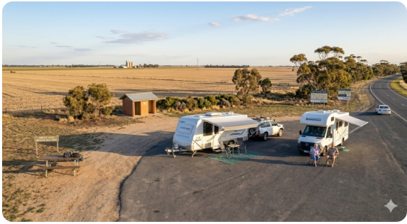
6. What to Expect on Arrival at Each Stop
The rest areas along this corridor are functional rather than scenic. Most are simple sealed or gravel pull-off areas with basic toilet blocks and shade trees — they do the job for an overnight rest but are not destinations in themselves. Expect other trucks, caravans and grey nomads at the popular stops, particularly on long weekends and school holiday periods. Standards of maintenance vary — some areas are immaculate; others have had facilities out of service for extended periods without clear repair timelines.
- Toilet blocks are present at most stops but cleanliness and accessibility vary — carry your own toilet paper and hand sanitiser as a matter of routine
- Lighting at highway rest areas is minimal — carry a good torch or headlamp for nighttime movements around the van
- Shade is limited at some stops, particularly on the flat open sections west of Horsham — a caravan annex or shade sail is genuinely useful in summer
- Noise from passing trucks on the Western Highway can be significant at roadside stops — earplugs or a white noise machine can significantly improve sleep quality
- The most popular stops — particularly Horsham and Nhill — fill up earlier than you might expect during peak season; plan to arrive well before 3pm if you want a good position
7. Safety for Senior Grey Nomads on This Route
Personal Safety
- Park with your entrance door facing the open area of the rest stop rather than facing the highway or a wall — this gives you a clear sightline and improves ventilation
- Lock your vehicle at night even in seemingly quiet rest areas — opportunistic theft does occur at highway stops, particularly near the Victorian–South Australian border
- If you are travelling solo, let a trusted contact know your planned stops each day and check in when you arrive — a simple text message system is sufficient
- Position your van under a light pole if available — it improves visibility and deters opportunistic activity
- Be alert at poorly lit rest areas and carry a personal alarm — understanding how caravan theft happens in Australia is the first step to preventing it
Trip Safety
- Carry a physical paper map as a backup — if your phone dies and your GPS fails in the open stretch between Nhill and Bordertown, you need a fallback
- Ensure your vehicle and caravan are serviced before departing — the nearest mechanic to some stops on this route is 60–80km away
- Carry a basic first aid kit, a spare tyre in good condition, and a roadside emergency kit including reflective triangles
- Register with Emergency Plus app (triple zero shortcut with GPS location sharing) before you leave Melbourne
- If you are on prescription medications, carry at least a 7-day supply buffer in case of unexpected delays — pharmacies are spaced widely along this route
8. Medical and Emergency Contacts Along the Corridor
| Service | Address | GPS (approx. within 50m) | Phone |
|---|---|---|---|
| Emergency (all) | Australia-wide | N/A | 000 |
| Healthdirect (nurse advice line) | Australia-wide (telephone) | N/A | 1800 022 222 |
| Horsham Rural City Hospital (Wimmera Health Care Group) | 83 Baillie Street, Horsham VIC 3400 | -36.7134, 142.2011 | (03) 5381 9111 |
| Bordertown Memorial Hospital (Tatiara District Council region) | 11 Woolshed Street, Bordertown SA 5268 | -36.3147, 140.7717 | (08) 8752 1011 |
| Ballarat Base Hospital (Grampians Health) | 1 Drummond Street North, Ballarat VIC 3350 | -37.5541, 143.8502 | (03) 5320 4000 |
| Keith and District Hospital | 37 Hill Street, Keith SA 5267 | -36.0983, 140.3531 | (08) 8755 1011 |
Note on GPS coordinates for hospitals: All hospital GPS coordinates are provided within approximately 50 metres of the confirmed facility location using publicly available data. Always verify the address on arrival and follow posted signage to the emergency department.
9. Dump Points, Water and Supplies Along the Route
Dump points are not present at highway rest areas along this corridor as a standard facility. You must use town-based dump points, which are available in most of the larger towns along the route. Planning your dump point stops in advance avoids the unpleasant situation of a full cassette or grey water tank with nowhere to empty it. The same applies to fresh water — do not assume roadside taps are operating or potable.
| Need | Best Nearby Option | Notes |
|---|---|---|
| Dump point (VIC) | Horsham (multiple locations in town), Nhill (council area), Ballarat (multiple) | Horsham is the most reliable and best-serviced dump point stop before the border. Do not leave it until Nhill if your tank is near capacity. |
| Dump point (SA) | Bordertown Caravan Park and Council facilities; Keith township | Confirm current availability with local council — SA dump point locations change periodically |
| Fresh water | Horsham, Nhill, Bordertown | Carry minimum 20L of your own drinking water at all times. Town water quality varies — Horsham water is reliable. |
| Groceries and fuel | Horsham (Woolworths, IGA, Coles), Bordertown (IGA), Keith (IGA) | Do not rely on small town servo offerings for a full shop. Horsham is your best grocery stop on the VIC side. |
| Major supplies and pharmacy | Horsham (Chemist Warehouse and independent pharmacies), Ballarat (full range) | Prescription medications: fill in Horsham if you are running low. Pharmacies west of Horsham are limited. |
| Alternative town if stop is full | Dimboola (between Horsham and Nhill), Kaniva (near border) | Kaniva is a small town just inside VIC near the SA border with a rest area and basic facilities. Useful overflow stop. |
10. Things to Do for Seniors Along the Melbourne to SA Route
This is not purely a transit corridor — there are genuinely worthwhile stops along the way that make the journey itself a highlight rather than just a means to an end. The Grampians region is accessible from Stawell and Halls Gap, the Wimmera Mallee region around Horsham and Dimboola has genuine character, and the Tatiara region in South Australia around Bordertown has a peaceful, unhurried quality that suits slow travellers well.
| Activity | Location | Why Seniors Like It |
|---|---|---|
| Grampians National Park — Halls Gap walks and lookouts | Halls Gap, 26km north of Stawell via Grampians Road | Flat walking paths to lookouts, wildlife spotting (kangaroos and emus), stunning rock formations — easy half-day from Stawell |
| Dimboola — Wimmera River walk | Dimboola township, along the Wimmera River | Short flat walk along a calm river with birdlife — ideal for an early morning stretch after an overnight rest stop |
| Horsham Botanic Gardens | Gardens Road, Horsham VIC 3400 | Heritage-listed gardens on the Wimmera River — flat paths, seats, free entry, café nearby — excellent for a 1–2 hour break |
| Little Desert National Park — nature drive | Kiata, south of Nhill via Kiata–Harrow Road | Drive-through wildlife spotting, mallee scrub, wildflowers in spring — no walking required if mobility is an issue |
| Bordertown — Bob Hawke’s Birthplace and Museum | Victoria Street, Bordertown SA 5268 | Small heritage display about Australia’s former Prime Minister — interesting for older Australians who lived through his era |
Best Senior-Friendly Ideas Along the Route
- Plan an extra night at Halls Gap or Horsham to explore at a relaxed pace rather than just passing through
- The Wimmera River precinct in Horsham has accessible walking paths and public toilets — ideal for a midday rest with a walk
- Birdwatching is genuinely outstanding around Dimboola and Little Desert National Park — bring binoculars
- The Bordertown wildlife park is a free, low-key experience with native animals — suitable for grandchildren travelling with you
- If you have time and energy, the short detour to Kaniva (near the border) for a quiet night away from highway noise is worth considering
For inspiration on making the most of travelling in retirement, the Living in Retirement on the Road guide covers the philosophy and practical reality of slow travel as a senior grey nomad.
11. Best Time of Year to Drive Melbourne to South Australia
| Season | What It Is Like | Senior Verdict |
|---|---|---|
| Summer (Dec–Feb) | Very hot on the Western Plains — temperatures regularly exceed 38°C west of Horsham. Fire risk HIGH. Flies severe. Rest area shade limited. | ⚠️ Not recommended for seniors without a fully air-conditioned self-contained rig. If you must travel in summer, drive early and stop by noon. |
| Autumn (Mar–May) | Temperatures moderate pleasantly. Harvest activity on farms. Good light. Wildflower season beginning in the Little Desert. Rest areas quieter than peak summer. | ✅ Excellent — one of the best times on this route. Cool nights, warm days, manageable flies, good visibility. |
| Winter (Jun–Aug) | Cold overnight temperatures — frost common on the Western Plains. Days are crisp and clear. Very few other travellers. Some rest areas can feel isolated. | ⚠️ Manageable for self-contained rigs with heating. Solo travellers should take extra care. Good time for CPAP users as cool air is easier on the machine. |
| Spring (Sep–Nov) | Outstanding wildflowers in the Wimmera and Little Desert. Warm, moderate temperatures. Route gets busier from October as grey nomad season begins properly. Mosquitoes near water in some areas. | ✅ Highly recommended — arguably the best season on this route. Book caravan parks early if you plan any powered nights. |
12. Fires, Generators and Overnight Etiquette
Highway rest areas along this corridor are not campgrounds and should not be treated as such. The rules around fires and generators exist to protect both the environment and the continued availability of these stops for all travellers.
- Open fires: Not permitted at highway rest areas in Victoria or South Australia. Open fires are restricted to designated fire pits or rings where specifically provided. Always check current Total Fire Ban status before lighting anything — bans apply across large regions and can be declared with little notice in summer.
- Generators: Permitted at most highway rest areas but courtesy hours apply — generators should not run before 7am or after 9pm. Keep noise levels considerate of other travellers, particularly truck drivers who need genuine rest.
- Rubbish: Leave no rubbish behind. If bins are full, take your rubbish to the next town — do not leave bags beside overflowing bins. Littering at rest areas is the primary reason for access to be restricted or withdrawn.
- Toilets: Use the facilities as you would wish to find them. If the toilet block is in poor condition on arrival, report it to the relevant road authority — VicRoads or DPTI SA — rather than simply leaving it for the next traveller to deal with.
- Noise: Loud music, running engines and extended generator use overnight are the most common complaints recorded at highway rest areas. Be a good neighbour.
- Grey water: Do not dump grey water on the ground at rest areas. Use a grey water container and dispose at a designated dump point. Grey water dumping is the second most common reason rest areas lose their overnight status.
13. Senior Packing Checklist for This Route
| Item | Why It Matters on This Route | Packed ☐ |
|---|---|---|
| Minimum 20L drinking water supply | Potable water unreliable west of Horsham and at SA border stops | ☐ |
| Offline maps downloaded (Google Maps or Maps.me) | Coverage drops significantly west of Nhill — do not rely on live navigation | ☐ |
| CPAP machine with 12V DC adapter and solar backup | No powered sites at highway rest areas — you need your own power source | ☐ |
| Current medications (7-day buffer supply) | Pharmacies are rare between Horsham and Bordertown | ☐ |
| Quality earplugs or white noise machine | Highway truck noise at roadside stops is significant — affects sleep quality | ☐ |
| Insect repellent and fly net | Flies are severe on the Western Plains from October to April | ☐ |
| Sun shade or annex | Rest areas west of Horsham have limited natural shade — essential in summer | ☐ |
| Physical paper map (VIC and SA) | Backup navigation for the Nhill–Bordertown coverage dead zone | ☐ |
| Grey water container (sealed) | No grey water disposal at highway stops — carry until a dump point | ☐ |
| Roadside emergency kit (reflective triangles, torch, jump leads) | Long gaps between towns and low traffic volumes at night on this route | ☐ |
For a complete senior-specific checklist beyond this route, the Grey Nomad Packing Checklist covers everything from medical to mechanical in a printable format.
COPY PROMPT ➔ ASK AI ➔ SAVE TO FORM ➔ ADD SPOT PIN ➔ GET DIRECTIONS
📍 Interactive map — find free camps, rest areas and overnight stops. Enable location for best results.
14. GPS Coordinates and Postcodes: Save Every Stop
Save these coordinates to your GPS device or phone before departing. All coordinates are within approximately 50 metres of the confirmed stop location using publicly available mapping data. Preparing your stops in advance is one of the most effective ways to reduce stress on a long-distance grey nomad drive.
| Location | Address and Postcode | GPS (approx. within 50m) | Notes |
|---|---|---|---|
| Horsham Rest Area (Western Hwy) | Western Highway, Horsham VIC 3400 | -36.7104, 142.1994 | Best mid-route stop in VIC — toilets, town services nearby |
| Nhill Rest Area (Western Hwy) | Western Highway, Nhill VIC 3418 | -36.3336, 141.6504 | Last major VIC stop before SA border — dump and refuel here |
| Bordertown Rest Area (Dukes Hwy) | Dukes Highway, Bordertown SA 5268 | -36.3108, 140.7699 | First SA stop after the border — toilets, town nearby |
| Wimmera Health Care Group (Horsham Hospital) | 83 Baillie Street, Horsham VIC 3400 | -36.7134, 142.2011 | Main hospital serving Western Highway corridor VIC — 24hr emergency |
| Bordertown Memorial Hospital | 11 Woolshed Street, Bordertown SA 5268 | -36.3147, 140.7717 | First hospital after crossing into SA — smaller facility, phone ahead for complex issues |
| Melbourne CBD (start point reference) | Melbourne VIC 3000 | -37.8136, 144.9631 | Route start — Western Ring Road or CityLink westbound to Western Hwy |
15. Frequently Asked Questions
Is the Melbourne to South Australia route free to travel with overnight stops?
Yes — the highway rest areas along the Western Highway in Victoria and the Dukes Highway in South Australia are free to use. There are no toll roads along the Western Highway west of Melbourne once you are past the metropolitan area (though CityLink tolls apply if you use the tunnel or freeway through the inner city — use the Western Ring Road to avoid tolls). The rest areas themselves have no fee for overnight stays within the permitted duration limits.
Can caravans and motorhomes stay overnight at highway rest areas on this route?
Generally yes, at formally designated rest areas. The key qualification is duration — most VicRoads rest areas permit stays up to 24 hours, while SA DPTI rest areas have variable limits. Always read the signage at each specific stop on arrival. Some roadside pull-offs that look like rest areas are not formally designated and may not permit overnight stays.
What is the GPS for the key stops on this route?
The primary GPS references — all within approximately 50 metres of the confirmed stop location — are: Horsham -36.7104, 142.1994; Nhill -36.3336, 141.6504; Bordertown -36.3108, 140.7699; Keith -36.1003, 140.3558. Full coordinates for all stops are in Section 1 and Section 14 of this guide. Always confirm against on-site signage on arrival.
Are there toilets at the highway rest areas along this route?
Yes at most stops — toilet blocks are present at the major rest areas including Horsham, Nhill and Bordertown. Accessibility varies. Not all toilets are DDA-compliant. Carry your own toilet paper and hand sanitiser as a standard precaution — facilities can be out of stock or temporarily out of service without warning.
Is there a dump point at the highway rest areas?
No — dump points are not provided at highway rest areas as a standard facility on this route. You must use town-based dump points. The most reliably located and serviced dump points along the corridor are in Horsham and Nhill (VIC) and Bordertown (SA). Do not leave your dump until Bordertown if your tank is near capacity after Horsham.
Can you get potable water at the rest areas?
Not reliably. Water availability at roadside rest areas along this corridor is inconsistent — some areas have tanks, others do not, and tanks that are present may be empty or shut off. Carry a minimum 20 litres of your own drinking water and treat any unmarked tap at a rest area as non-potable until confirmed otherwise. Restock in Horsham or Nhill.
Is this route safe for solo senior travellers?
Yes, with appropriate precautions. The Western Highway and Dukes Highway are well-travelled roads with reasonable traffic volumes during daylight hours. The open sections west of Horsham are less busy at night. Solo senior travellers should use a daily check-in system with a trusted contact, park in well-lit areas where available, and read the Grey Nomad Safety Tips guide before departing.
What is the nearest hospital to the western section of the route?
The Wimmera Health Care Group hospital at 83 Baillie Street, Horsham VIC 3400 (GPS: -36.7134, 142.2011 — within approximately 50 metres of the confirmed location, phone (03) 5381 9111) is the primary hospital serving the Western Highway corridor in Victoria. In South Australia, the Bordertown Memorial Hospital at 11 Woolshed Street, Bordertown SA 5268 (GPS: -36.3147, 140.7717 — within approximately 50 metres of the confirmed location, phone (08) 8752 1011) is the first major hospital after crossing the border.
What is the best single overnight stop for senior grey nomads on this route?
Horsham is broadly considered the best single overnight stop for grey nomads on the Victorian section — it has the best facilities, the most services, reliable mobile coverage, a dump point, hospital access and interesting things to do including the Botanic Gardens and Wimmera River precinct. For the South Australian section, Bordertown is the equivalent first-choice stop — it is the first SA town with a full range of services after the border crossing, and the Bordertown Caravan Park is a good option if you want a powered night.
16. Quick Verdict — Is This Route Right for Senior Grey Nomads?
The Melbourne to South Australia run via the Western Highway and Dukes Highway is one of Australia’s most senior-friendly long-distance routes. The road is well-maintained, the distances between towns are manageable, the stops are well-spaced for a two or three-day itinerary, and the facilities — while not luxurious — are functional and consistent. Horsham stands out as the best mid-route stop in Victoria with genuine amenity, and the spring wildflower season between September and October transforms what might otherwise feel like a featureless agricultural transit into a genuinely memorable journey. The route suits self-contained caravans and motorhomes of all sizes.
The honest limitations are worth knowing: the section between Nhill and Bordertown is the weakest link — limited mobile coverage, no towns for nearly 100 kilometres, and a flat featureless landscape that can induce fatigue faster than you expect. The open-plain crosswinds between Horsham and the border are a genuine challenge for high-sided rigs in certain weather conditions. And the rest areas, while adequate, are transit stops rather than destinations — if you want a comfortable night with power, a dump point on-site and a hot shower, you will need a caravan park, and those are available in most of the larger towns along the route.
This is a solid, well-supported grey nomad route that rewards those who plan their stops in advance and travel at a relaxed pace. Break it into at least two days — ideally three if you want to explore Horsham, Dimboola or the Grampians. Horsham is your essential re-supply and rest point. Nhill is your last significant stop before the border. For a broader look at the free camping options across Victoria in 2026, or to explore van life savings strategies that stretch your travel budget further, those guides are the logical next step.
- Ballarat Rest Areas — your first major stop west of Melbourne
- Ararat Rest Areas — midway between Ballarat and Stawell
- Stawell Rest Areas — gateway to the Grampians
- Horsham Rest Areas — the best mid-route stop in Victoria
- Dimboola Rest Area — a quiet stop on the Wimmera River
- Free Camping Victoria 2026 — complete state guide
- Rest Areas Victoria 2026 — full hub
- Mildura Rest Areas — for travellers coming via the Murray River
- Echuca Rest Areas — Murray River route connection
- Cobram Rest Area — northern Victoria connection point
- Albury Rest Area — for travellers connecting via NSW
- Holbrook Rest Area — Hume Highway NSW connector
- Free Camping NSW 2026 — for cross-border planning
- Rest Areas NSW 2026 — full NSW hub
Local Amenities: Horsham is the primary service centre with supermarkets, pharmacy, hospital, dump point and fuel. Nhill has basic services including fuel and IGA. Bordertown has IGA, fuel and a caravan park.
Essentials to Bring: Minimum 20L water, offline maps, earplugs, grey water container, 7-day medication buffer, sun shade, physical road map.
- Site suitable for: Caravans, motorhomes, campervans — all sizes on sealed highway; large rigs should allow extra stopping distance
- Road access: Fully sealed — Western Highway (A8) and Dukes Highway (A8)
- Site surface: Varies by stop — sealed apron at most major rest areas; some have gravel bays
- Camping permitted: Overnight stays permitted at designated rest areas — duration limits apply, check signage at each stop
- Maximum overnight stays: Typically 24 hours at VIC rest areas; SA varies — check signage on arrival
- Boat ramp: No — not applicable to highway rest areas on this route
- Picnic tables: Yes — at most major rest areas along the corridor
- Potable water: Not reliable — carry your own. Available in towns (Horsham, Nhill, Bordertown).
- Mobile phone coverage: Good in towns; patchy to none between Nhill and Bordertown — Telstra performs best
- TV reception: Yes — most areas along route receive standard digital TV in towns; reception variable at open rest stops
- Rubbish bins: Yes — at most major rest areas; may overflow in peak season
- Open fires: No — not permitted at highway rest areas. Subject to Total Fire Bans — always check before travel.
- Generator use: Yes — permitted with consideration for other campers. Quiet hours: 9pm to 7am recommended.
- Number of sites available: Varies by stop — Horsham and Nhill have the largest capacity. No formal site allocation — first in, best dressed.
Free campsites and powered sites fill fast during school holidays and peak season. If your preferred site is already gone, search remaining accommodation options below to explore the region.
Accommodation and flight search powered by Expedia. Booking through this search supports this website at no extra cost to you. As an affiliate, I earn from qualifying purchases at no extra cost to you.

As an affiliate, I earn from qualifying purchases at no extra cost to you.
Exclusive Offer: Get 5% OFF all StarterStopper immobiliser products with promo code: RTV5
Visit StarterStopper.com to see our data-backed security solutions
As an affiliate, I earn from qualifying purchases at no extra cost to you.