Free Camping Tasmania: The Complete Grey Nomad Circuit Guide
Everything you need to plan the full Tasmania grey nomad circuit — from the Spirit of Tasmania ferry arrival at Devonport through to Launceston, the East Coast, Hobart, the Huon Valley, Strahan, Queenstown and Cradle Mountain, with free and low-cost camp sites, GPS references, facilities, safety notes and honest advice at every stop.
📅 Last reviewed: May 2026 | Tasmania Full Circuit | Free camping, low-cost sites and rest areas — rules and facilities vary by stop
Most grey nomads who make it to Tasmania say the same thing afterwards: they wish they had planned it better and stayed longer. Free camping in Tasmania is genuinely different from the mainland — the island is smaller, the crowds thinner outside summer, and the commitment of a Spirit of Tasmania ticket means everyone arriving has already done more research than the average roadside stopper. That research instinct is exactly right, because Tasmania rewards the prepared traveller and quietly punishes the one who wings it. Roads narrow without warning. Weather shifts from warm sunshine to horizontal sleet in forty minutes. Some of the best free camps sit two kilometres off the highway on unsealed tracks that look fine on a map and are emphatically not fine with a 25-foot van behind you. This guide covers the complete grey nomad Tasmania circuit — the full loop from the Devonport ferry terminal through to Launceston, down the East Coast, into Hobart, south to the Huon Valley, across to the wild West Coast at Strahan and Queenstown, north to Cradle Mountain and back to Devonport for the return sailing — with honest, specific information at every stop.
- The full loop is approximately 2,400 kilometres depending on side trips — most grey nomads allow 2 to 4 weeks for a comfortable pace
- Tasmania has no dedicated free camping legislation equivalent to Queensland’s rest areas — free camping exists on crown land, council-designated areas and some national park boundaries, and rules vary significantly between councils
- Self-contained certification is required at most designated free camps — carry your Campervan and Motorhome Club of Australia (CMCA) or equivalent documentation
- Telstra provides the broadest regional coverage in Tasmania — Optus is adequate in major centres but sparse on the West Coast and some East Coast sections
- West Coast roads including the road into Strahan and the Lyell Highway can be genuinely challenging for long rigs in wet weather — check conditions before departing Hobart
- The Spirit of Tasmania operates from Station Pier Melbourne and arrives at Devonport — book well ahead in summer (December to February) as vehicle deck space sells out months in advance
- Cradle Mountain National Park entry requires a Parks Pass — purchase online before arrival as signal at the park gate can be unreliable
- Dump points are less frequent on the West Coast than elsewhere — plan tank capacity carefully between Strahan and Cradle Mountain
What You Will Find in This Guide
- Why Tasmania Works So Well for Grey Nomads
- The Ferry Factor — What to Expect Arriving at Devonport
- The Full Circuit at a Glance
- Stop 1 — Devonport: Ferry Arrival and First Night
- Stop 2 — Launceston: Northern Tasmania Base
- Stop 3 — East Coast: Freycinet, Bicheno and St Helens
- Stop 4 — Hobart: The Capital
- Stop 5 — Huon Valley: The Southern Loop
- Stop 6 — Strahan and Queenstown: The Wild West
- Stop 7 — Cradle Mountain: The High Country
- Free Camping Rules in Tasmania — What You Must Know
- Self-Contained Requirements in Tasmania
- Mobile Coverage Across the Circuit
- Fuel Planning for the Tasmania Circuit
- Medical and Emergency Contacts for the Circuit
- Best Time of Year to Do the Circuit
- Fires, Generators and Etiquette in Tasmania
- Grey Nomad Tasmania Packing Checklist
- Frequently Asked Questions
- Quick Verdict — Is Tasmania Worth the Ferry Ticket?
Why Tasmania Works So Well for Grey Nomads
Tasmania is the only Australian state where you are guaranteed to arrive at your first overnight stop having already committed to the journey. The Spirit of Tasmania crossing — eleven hours overnight from Melbourne — functions as a natural filter. By the time you drive off the ramp at Devonport at 6am, you have booked the ticket, packed deliberately, and thought about where you are going. That level of pre-commitment produces a different quality of traveller and, frankly, a different quality of experience.
The island’s compact size is deceptive. At roughly 68,000 square kilometres Tasmania is smaller than Ireland, but it packs in an extraordinary range of terrain — alpine wilderness, button-grass plains, temperate rainforest, the dolerite columns of the Hazards at Freycinet, the eerie green of the Gordon River, the industrial heritage of Queenstown’s copper-stripped hills. You do not drive enormous distances to feel like you have crossed into a different world. A two-hour drive from Launceston south delivers you to the East Coast’s white sand beaches. A two-hour drive west from Hobart puts you in the kind of silence most Australians never encounter.
For grey nomads specifically, the smaller scale means less fatigue. Drives between stops are rarely more than two to three hours. Services — fuel, medical, supplies — are closer together than in outback Western Australia or the Gulf of Carpentaria. And outside the December to February summer peak, free camps and low-cost sites are genuinely uncrowded. If you are arriving in May, June, September or October you will find Tasmania at its most beautiful and least busy.
Because Tasmania is small, you can afford to slow down at every stop without losing the full circuit. Build in at least one full rest day at Freycinet, one at Strahan and one at Cradle Mountain. These are not places to drive through — they are the reason you came.
The Ferry Factor — What to Expect Arriving at Devonport
The Spirit of Tasmania docks at the TT-Line Terminal on The Esplanade, Devonport. Overnight crossings typically arrive between 6:00am and 7:30am depending on sea conditions and schedule. This matters more than most guides acknowledge, because a 6am arrival means you are driving off a ferry in the dark or early light, potentially after a poor night’s sleep on a moving vessel, towing a van or motorhome, into an unfamiliar city, needing to immediately make decisions about where to go and what you need.
The practical answer is to plan your first night before you leave Melbourne. Do not assume you will figure it out on arrival. The area immediately around the Devonport terminal has a small number of rest areas and a larger number of caravan parks within 15 minutes. Knowing exactly where you are going when you drive off that ramp removes an enormous amount of stress.
The drive off the Spirit of Tasmania ramp puts you immediately onto The Esplanade heading into central Devonport. If you have not pre-planned your route, you will be making navigation decisions in the first three minutes of being in Tasmania while fatigued and potentially in low light. Program your GPS the night before on the boat. Know your first stop. Do not leave this to arrival morning.
For full detail on Devonport rest areas, overnight stops near the terminal, facilities and GPS coordinates, see the dedicated guide: Free Camping Near Devonport: Best Rest Areas After the Spirit of Tasmania.
The Full Circuit at a Glance
The classic grey nomad Tasmania circuit follows a logical loop that takes in the ferry arrival point, the two major cities, the spectacular East Coast, the deep south, the wild West Coast and the alpine high country before returning to the ferry. The order below is the recommended direction — clockwise from Devonport, down the East Coast to Hobart, west to Strahan, north to Cradle Mountain and back to Devonport. You can reverse it, but the clockwise direction puts the most dramatic scenery — the West Coast and Cradle Mountain — in the second half of the trip when you are most relaxed and familiar with Tasmanian driving conditions.
| Stop | Location | Approx Drive from Previous Stop | Dedicated Guide |
|---|---|---|---|
| Ferry Arrival | Devonport — TT-Line Terminal | — | Devonport Free Camping Guide |
| Stop 1 | Launceston | 1h 10min (100km via A1) | Launceston Free Camping Guide |
| Stop 2 | East Coast — Freycinet, Bicheno, St Helens | 2h–2h 30min (180–200km via A3/A4) | East Coast Tasmania Free Camping Guide |
| Stop 3 | Hobart | 2h 30min from Freycinet (200km via A3) | Hobart Free Camping Guide |
| Stop 4 | Huon Valley | 45min from Hobart (50km via B64) | Huon Valley Free Camping Guide |
| Stop 5 | Strahan and Queenstown | 3h 30min from Hobart (260km via A10 Lyell Hwy) | Strahan and Queenstown Free Camping Guide |
| Stop 6 | Cradle Mountain | 2h 30min from Strahan (160km via C132/A10) | Cradle Mountain Free Camping Guide |
| Return | Devonport — Ferry Departure | 1h 30min from Cradle Mountain (85km via B14/A1) | Devonport Free Camping Guide |
Drive times above are approximate and do not account for stops, slow trucks on mountain roads or weather delays. On the Lyell Highway between Hobart and Queenstown, budget at least an extra 30 minutes over Google Maps estimates when towing. The road is genuinely beautiful and genuinely winding.
Stop 1 — Devonport: Ferry Arrival and First Night
Devonport is a working port city of around 25,000 people. It is not Tasmania’s most dramatic destination, but it has everything you need for the first 24 to 48 hours after the crossing — supermarkets, pharmacies, fuel, a hospital, and several free and low-cost overnight options within easy reach of the terminal. The city also has the Tiagarra Aboriginal Cultural Centre and the House of Anvers chocolate factory, both of which are worth a morning stop before heading inland.
What to Do on Your First Morning
- After driving off the ferry, find your first camp and sleep before driving further — fatigued driving after an overnight crossing is a genuine risk
- Fill water tanks and dump grey water near Devonport before heading south — services become less frequent south of Launceston on some routes
- Fill fuel in Devonport — prices here are generally lower than regional Tasmania
- Buy groceries at one of the major supermarkets before heading east or south
- Check the TasAlerts website and Bureau of Meteorology Tasmania forecast before proceeding — Tasmanian weather can change the viability of some camps quickly
An overnight Spirit of Tasmania crossing is not restful sleep. The vessel moves, the noise is constant in lower-deck cabins, and the 6am arrival demands immediate alertness behind the wheel. If you are towing, pull over at the first available rest area after the terminal and sleep for two hours before driving further. No camp is worth a fatigue-related accident on an unfamiliar road.
For full details on specific free camps, rest areas, GPS coordinates and facilities near Devonport, see the dedicated guide: Free Camping Near Devonport: Best Rest Areas After the Spirit of Tasmania.
Stop 2 — Launceston: Northern Tasmania Base
Launceston is Tasmania’s second city and the gateway to the Tamar Valley wine region, the Cataract Gorge (one of the most accessible natural attractions in Australia for seniors — a flat riverside walk leads to the first basin and the chairlift), and the Ben Lomond alpine plateau to the east. At around 100,000 people, it has full services — two major hospitals, all major supermarkets, large fuel stations and a reasonable selection of free and low-cost camps within 20 to 40 kilometres of the centre.
What Other Guides Miss About Launceston
Most grey nomad content focuses on the Cataract Gorge and moves on. What gets overlooked is the Tamar Valley loop north of the city — a sealed road circuit through Rosevears, Grindelwald and Exeter that takes in genuine vineyard scenery, cellar doors open to seniors travelling mid-week, and a handful of free camps along the Tamar River foreshore that are significantly quieter than anything close to the Gorge. The drive is flat, the roads are good for towing and the views across the Tamar to the western ranges are genuinely beautiful.
Launceston also has one of Tasmania’s better hospital facilities at Launceston General Hospital — relevant for grey nomads with complex medical needs who want to be reasonably close to specialist care during their first few days in the state.
After the overnight ferry crossing and the first night at Devonport, Launceston is an excellent place to spend a full day resetting — laundry, groceries, a proper dump and fill, a walk through the Gorge, and a relaxed afternoon at a vineyard. You will be better prepared for the East Coast drive south.
For specific free camps, GPS coordinates, dump point locations and facilities near Launceston, see: Free Camping Near Launceston: Top Spots for Grey Nomads in Northern Tasmania.
Stop 3 — East Coast: Freycinet, Bicheno and St Helens
The East Coast of Tasmania is where most grey nomads fall in love with the island. The Tasman Highway south from St Helens through Bicheno and down to the Freycinet Peninsula is one of the genuinely great Australian coastal drives — and unlike the Great Ocean Road or the Pacific Coast Highway, it is largely unhurried, uncrowded outside summer, and blessed with a series of small towns and accessible beaches that make it ideal for slow travel.
Freycinet Peninsula
Wineglass Bay is the headline attraction and deserves it — but the walk to the lookout is a genuine climb and is not accessible for all grey nomads. The alternative is to take the boat cruise from Coles Bay, which delivers the view without the elevation gain. Operators run half-day and full-day trips from the Coles Bay boat ramp area. Bookings are essential in peak season.
Camping at Freycinet National Park requires a Parks Pass and advance booking through the Parks Tasmania website. There is no free camping inside the park. The nearest free and low-cost options are outside the park boundary and are covered in the dedicated East Coast guide.
Bicheno
Bicheno is underrated as a grey nomad stop. The blowhole walk is flat and accessible, the town has a supermarket, fuel and a bakery, and the little penguin colony at Bicheno Penguin Tours operates nightly guided walks that are genuinely moving — small groups, no flash photography, and the penguins return to their burrows at dusk within walking distance of town. Bookings essential.
St Helens
St Helens at the northern end of the East Coast run is a proper service town — fuel, supermarket, medical centre and a range of camping options including some of the East Coast’s more accessible free camps near the Georges Bay foreshore. Many grey nomads use St Helens as a base for two or three nights and day-trip south to Bay of Fires without moving camp.
The Tasman Highway between St Helens and Bicheno includes several sections with narrow shoulders and tight bends, particularly around the Elephant Pass area. Elephant Pass Road (the old route) is not suitable for long rigs. Stay on the Tasman Highway main route. Allow extra time and do not tailgate — local logging trucks use this corridor.
For specific free camps, GPS, facilities and more detail on Freycinet, Bicheno and St Helens, see: Free Camping East Coast Tasmania: Freycinet, Bicheno and St Helens Grey Nomad Guide.
Stop 4 — Hobart: The Capital
Hobart is the smallest and arguably most liveable of Australia’s state capitals. For grey nomads it offers full services, excellent food markets (the Salamanca Market on Saturday morning is genuinely one of Australia’s best), Mount Wellington (renamed kunanyi) rising directly behind the city to 1,271 metres, and the remarkable MONA — the Museum of Old and New Art — which is either the most extraordinary art museum in Australia or deeply confronting depending on your sensibilities, and worth at least a look.
Free camping in central Hobart does not exist — but there are a number of low-cost options in the suburbs and within 30 kilometres of the CBD, and the Hobart Showground and several caravan parks provide powered sites at reasonable rates for those wanting a full-service stop. The city also has excellent medical facilities including the Royal Hobart Hospital.
What Most Guides Miss About Hobart
The best grey nomad experience in Hobart is not in the centre — it is the drive south along the Channel Highway toward Huonville, which begins to reveal the orchard country and quiet river towns of the Huon Valley. Many grey nomads fly through Hobart in a day and miss the fact that the Huon Valley is 45 minutes south and is one of the genuinely beautiful and undervisited parts of the circuit.
Arrive in Hobart on a Friday afternoon, camp nearby, and spend Saturday morning at the Salamanca Market. It opens at 8:30am and is at its best before 10:30am before the crowds build. Then drive the 45 minutes south to Huonville for Saturday afternoon.
For specific free and low-cost camps near Hobart, dump points, GPS and facilities, see: Free Camping Near Hobart: Best Free and Low-Cost Sites for Campervans and RVs.
Stop 5 — Huon Valley: The Southern Loop
The Huon Valley is Tasmania’s apple country — and in autumn (March to May) the orchards are at their most beautiful, with harvest activity visible from the road and roadside stalls selling fruit that has been off the tree for hours. The Huon River is wide and calm through this section, the towns of Huonville, Geeveston and Cygnet are genuinely charming, and the drive out to Cockle Creek in the south — the southernmost point accessible by sealed road in Australia — is one of the more extraordinary things you can do in a caravan or motorhome on this continent.
Cockle Creek is free to camp at and is managed by the Tasmania Parks and Wildlife Service. It is within the Southwest National Park boundary. You need no Parks Pass to camp at Cockle Creek itself, but the area has no facilities and is genuinely remote. Carry everything you need including water. The drive from Huonville to Cockle Creek is approximately 70 kilometres and takes around 90 minutes — the last section on Cockle Creek Road is unsealed but generally suitable for most rigs in dry conditions. Check conditions before departing.
Cockle Creek Road beyond Recherche Bay can deteriorate significantly after heavy rain. It is unsealed for the final section and not suitable for large rigs in wet weather. If in doubt, stop at Recherche Bay and walk or use a smaller vehicle. Do not attempt the final section if the road surface looks compromised — recovery in this location is very difficult and mobile coverage is essentially nil.
For specific camp sites, GPS, facilities and more on the Huon Valley circuit, see: Free Camping Huon Valley: Southern Tasmania Grey Nomad Guide.
Stop 6 — Strahan and Queenstown: The Wild West
Nothing else on the Tasmania circuit — and very little else in Australia — prepares you for the West Coast. Queenstown rises out of the landscape like a geological wound, its copper-leached hills stripped of vegetation and stained in colours that shift from rust to ochre to grey depending on the light. It is genuinely strange and genuinely compelling. The town itself is a working-class mining community that has reinvented itself for tourism without losing its character, and it is worth a morning stop before dropping down the Gordon River Road to Strahan.
Strahan is the only significant town on Tasmania’s entire West Coast — a population of around 700 people serving the Gordon River cruise industry. The Gordon River cruise is the highlight of the West Coast for most grey nomads — a full-day return journey through Heritage Landing rainforest and Sarah Island, the ruins of Australia’s most brutal convict settlement. Book in advance through World Heritage Cruises or Gordon River Cruises. Full-day cruises depart in the morning and return by late afternoon.
What Most Guides Miss About the West Coast
The drive from Hobart to Queenstown on the Lyell Highway (A10) is one of the great Australian road experiences — but it is also one of the more demanding for towing. The highway crosses the Central Plateau at over 1,000 metres and descends into Queenstown via the famous series of hairpin bends known locally as the Gorge Road. These bends are sealed and manageable for most rigs, but they require full concentration, appropriate gear selection and patience with the vehicles behind you. Use your low gear selector on the descent and do not ride the brakes.
The Lyell Highway between Derwent Bridge and Queenstown is subject to ice and black ice in winter months (June to August) and can close without warning in severe conditions. Check the TasRoads (transport.tas.gov.au) road conditions page before departing Hobart in the cooler months. Do not assume conditions at Hobart reflect conditions at altitude.
For specific free and low-cost camps at Strahan and Queenstown, GPS, facilities and driving notes, see: Free Camping Strahan and Queenstown: West Coast Tasmania Grey Nomad Guide.
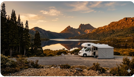
Stop 7 — Cradle Mountain: The High Country
Cradle Mountain is the icon of Tasmanian wilderness — the jagged dolerite summit reflected in Dove Lake, the ancient pencil pine forests, the wombats that wander the Ronny Creek boardwalk at dusk with complete indifference to human observers. It is extraordinary. It is also cold, wet and frequently foggy, and the Park’s visitor infrastructure has changed significantly in recent years.
The Cradle Mountain Shuttle Bus now operates within the park and is the recommended way to access Dove Lake from the visitor centre, regardless of whether you have a vehicle. Private vehicle access to the lake is restricted at peak times — the shuttle operates frequently and is genuinely accessible for most mobility levels. The Parks Pass is required for entry and can be purchased online or at the visitor centre.
Free camping does not exist inside Cradle Mountain – Lake St Clair National Park. The nearest free and low-cost camps are outside the park boundary, ranging from a few kilometres to around 20 kilometres from the visitor centre. Many grey nomads base at one of these camps and day-trip into the park. The drive back to Devonport from Cradle Mountain is approximately 85 kilometres and takes around 90 minutes — plan to arrive at Devonport at least two hours before your scheduled Spirit of Tasmania departure.
Cradle Mountain sits at around 1,000 metres elevation and is subject to rapid weather changes at any time of year. In May and June — autumn into early winter — snow is possible and temperatures can drop below freezing overnight. If you are camping outside the park near Cradle Mountain, carry appropriate cold-weather gear regardless of the weather in Hobart or Devonport. The altitude difference is significant.
For specific free camps near Cradle Mountain, GPS, facilities and seasonal notes, see: Free Camping Near Cradle Mountain: Best Nearby Sites Outside the National Park.
Free Camping Rules in Tasmania — What You Must Know
Tasmania does not have a single statewide free camping framework equivalent to Queensland’s rest area network. Free camping in Tasmania falls across several categories — crown land, council-managed reserves, Parks Tasmania managed areas, and roadside rest areas managed by the Department of State Growth — and the rules are different for each category and each council area.
| Land Type | Who Manages It | Rules Overview | Where to Check |
|---|---|---|---|
| National Parks | Parks Tasmania | Parks Pass required. Designated camp sites only. No free camping outside designated areas. Book in advance for popular sites. | parks.tas.gov.au |
| Crown Land | Department of Natural Resources and Environment Tasmania | Generally permitted but varies by area. Check before camping. No facilities in most cases. | nre.tas.gov.au |
| Council Reserves | Individual councils | Highly variable. Some councils permit free camping with time limits; others prohibit it entirely. Always check local signage. | Relevant council website |
| Roadside Rest Areas | Dept of State Growth | Short rest stops only — not designated for overnight camping. Some are tolerated for one night but this can change. | transport.tas.gov.au |
| State Forests | Forestry Tasmania | Camping generally permitted in designated areas. Road access varies — some tracks close seasonally. | forestrytas.com.au |
In Tasmania as everywhere in Australia, any signage present on the ground when you arrive takes legal precedence over any website, app or guide including this one. Rules change. Councils update bylaws. Parks Tasmania reviews access conditions seasonally. Always read signage on arrival and comply with whatever it states regardless of what you read online.
Use WikiCamps Australia and CamperMate to cross-reference free camps before arriving at any location. Both apps carry community-updated information on rule changes, closures and conditions. Download both for offline use before leaving Devonport or Launceston — coverage becomes patchy on the West Coast and in some rural areas.
Self-Contained Requirements in Tasmania
Many of Tasmania’s designated free camping areas require self-contained certification. Self-contained means your vehicle has an onboard toilet that is entirely contained within the vehicle, fresh water storage sufficient for your stay, and grey water storage that does not discharge onto the ground. It does not simply mean you have a portable camping toilet — the toilet must be permanently installed and the grey water system must be contained.
Certification in Tasmania
Tasmania recognises the CMCA (Campervan and Motorhome Club of Australia) self-contained certificate and the NZ Caravan Association certificate. Some council areas require current certification displayed in the windscreen when using self-contained-only areas. Carry your documentation and display it proactively — it demonstrates good faith to rangers and other campers and reduces the risk of being moved on.
- CMCA or equivalent self-contained certificate — original, not a phone photo
- Cassette toilet or equivalent fully contained waste system operational and empty on arrival
- Grey water tank capacity sufficient for your planned stay without overflow
- Fresh water tank filled before arriving at remote free camps — do not assume water is available on site
- Dump point planned for every two to three days of travel — check campermate.com.au/dump-points before departing each stop
For broader context on the difference between free camping and overnight parking rules across Australia, see: Free Camping vs Overnight Parking in Australia.
Mobile Coverage Across the Circuit
Telstra provides the best and most consistent coverage across the Tasmania circuit. It is not continuous — the West Coast in particular has significant gaps — but for the major stops Telstra is reliable. Optus is adequate in Hobart, Launceston and Devonport but deteriorates rapidly in regional and rural areas. Vodafone/TPG coverage in regional Tasmania is limited and should not be relied upon outside major centres.
| Stop | Telstra | Optus | Notes |
|---|---|---|---|
| Devonport | Good | Good | Full 4G/5G in town |
| Launceston | Good | Good | Full 4G/5G in town |
| East Coast (St Helens) | Good | Patchy | Gaps south of St Helens on Tasman Hwy |
| East Coast (Freycinet/Bicheno) | Patchy | Poor | Coles Bay has limited coverage — download maps before leaving Bicheno |
| Hobart | Good | Good | Full 4G/5G in town |
| Huon Valley | Patchy | Poor | Gaps south of Huonville. Cockle Creek — essentially nil |
| Strahan/Queenstown | Patchy to Poor | Very Poor | West Coast is the worst coverage zone in Tasmania. Do all calls and downloads before leaving Hobart. |
| Cradle Mountain | Patchy | Poor | Visitor centre area has some coverage — remote camp sites may have none |
Between Queenstown and Strahan, and on much of the Lyell Highway west of Derwent Bridge, mobile coverage of any carrier is unreliable to non-existent. Before leaving Hobart for the West Coast, make all medical check-in calls, update your family or travel companion on your route plan, download offline maps for the full West Coast section using Maps.me or Google Maps offline, and download WikiCamps and CamperMate for offline use. Carry a personal locator beacon (PLB) if you have one. On the West Coast, 000 may not connect from your phone.
Download offline maps for the full Tasmania circuit before leaving Devonport. Use Maps.me or Google Maps offline. WikiCamps Australia (wikicamps.com.au) and CamperMate (campermate.com.au) both work offline once downloaded. Do this on the ferry or in Devonport while you still have reliable Wi-Fi. Also enable Emergency Plus on your phone — it uses GPS to provide your exact coordinates to emergency services even without mobile data, which is critical in coverage black spots.
Fuel Planning for the Tasmania Circuit
Fuel planning in Tasmania is simpler than outback Australia but more complex than driving between major mainland cities. The key danger zones are the West Coast and the remote sections of the East Coast south of Swansea. Fuel in Tasmania is generally more expensive than mainland cities and cheapest in Hobart, Launceston and Devonport. Regional prices can be 20 to 35 cents per litre higher than city prices.
| Section of Circuit | Key Fuel Stops | Max Gap (Approx) | Notes |
|---|---|---|---|
| Devonport to Launceston | Devonport, Launceston | 100km | No fuel anxiety — frequent stops |
| Launceston to St Helens | Launceston, St Helens, Scottsdale (if via B82) | 160km | Fill at Launceston before heading east |
| East Coast — St Helens to Hobart | St Helens, Bicheno, Swansea, Orford | 80–90km | All stops have fuel but prices increase south of Bicheno |
| Hobart to Queenstown (Lyell Hwy) | Hobart, Hamilton, Ouse, Derwent Bridge, Queenstown | 115km (Ouse to Derwent Bridge) | Fill at Hobart. Verify Derwent Bridge has diesel before departing Ouse |
| Queenstown to Strahan | Queenstown, Strahan | 40km | Short run — fill at Queenstown |
| Strahan to Cradle Mountain | Strahan, Tullah, Rosebery, Cradle Mountain area (limited) | 100km+ | Fill at Strahan. Verify fuel availability at Tullah before proceeding. Cradle Mountain area fuel is limited and expensive. |
| Cradle Mountain to Devonport | Sheffield, Devonport | 85km | Sheffield has fuel — straightforward run |
Use PetrolSpy to compare fuel prices across Tasmania before you fill up. It is free, updated daily by users and works in most Tasmanian regional areas when you have coverage. Search by postcode for the most accurate results. The difference between a full tank at Hobart prices versus Strahan prices on a 90-litre diesel tank can be $25 to $35 — real money over a four-week circuit.
On the Lyell Highway and the road between Strahan and Cradle Mountain, the rule is simple — if your tank is below half when you reach a fuel stop, fill it. The distances are not extreme but the fuel stops are limited and some — particularly Tullah and Derwent Bridge — operate limited hours and may be closed in the early morning or evening when you arrive. There are no emergency fuel deliveries on the West Coast.
Medical and Emergency Contacts for the Circuit
Tasmania has strong medical infrastructure in its three main centres — Hobart, Launceston and Devonport. On the West Coast and in remote southern areas, the picture changes significantly. Strahan’s nearest hospital is in Queenstown (approximately 40 kilometres) and the Queenstown facility is a small district hospital with limited specialist capacity. For serious cardiac events, stroke or major trauma on the West Coast, evacuation by Royal Flying Doctor Service or road to Hobart (approximately 3.5 hours) is the realistic outcome.
| Service | Location | Phone | Notes |
|---|---|---|---|
| Emergency | All locations | 000 | Use Emergency Plus app for GPS coordinates if mobile data is unavailable |
| Royal Hobart Hospital | 48 Liverpool St, Hobart TAS 7000 | (03) 6166 8308 | Major trauma and specialist centre. Emergency department 24 hours. |
| Launceston General Hospital | 274–280 Charles St, Launceston TAS 7250 | (03) 6777 6777 | Second major hospital. Emergency department 24 hours. |
| Mersey Community Hospital | Brickport Rd, Latrobe TAS 7307 | (03) 6426 5400 | Nearest hospital to Devonport — approximately 10km from ferry terminal. Emergency department. |
| West Coast District Hospital (Queenstown) | Driffield St, Queenstown TAS 7467 | (03) 6471 5211 | Small district hospital. Limited specialist capacity. For serious emergencies, evacuation to Hobart. |
| Healthdirect | National phone service | 1800 022 222 | 24-hour medical advice line. Free call. Useful for non-emergency medical questions on the road. |
| RFDS Tasmania | Based at Cambridge Airport, Hobart | See rfds.org.au | Covers remote Tasmania. If you are in a genuine remote emergency and 000 connects, RFDS will be coordinated through Ambulance Tasmania. |
If you or your travel partner has a serious cardiac condition, recent stroke history, insulin-dependent diabetes requiring clinical monitoring, or any condition requiring rapid specialist intervention, discuss the West Coast section of this circuit with your GP before departing. Strahan to Hobart by road is approximately 3.5 hours. The RFDS covers the region but weather and terrain can delay response. This is not a reason to avoid the West Coast — it is a reason to plan carefully, carry adequate medication, and ensure someone knows your itinerary and expected check-in times.
For broader grey nomad safety planning before your departure, see: Grey Nomad Safety Tips and the Grey Nomad Road Safety Checklist.
Best Time of Year to Do the Tasmania Circuit
| Season | What It Is Like | Temperature Range | Senior Verdict |
|---|---|---|---|
| Summer (Dec–Feb) | Warmest and busiest. Long days, reliable weather, full services everywhere. Cradle Mountain and East Coast at their most crowded. Ferry and camp bookings sell out months ahead. | Hobart 18–24°C. Cradle Mountain 10–18°C. Occasionally over 30°C in Hobart. | Best weather, worst crowds. Book everything 3–4 months ahead. Avoid if you hate queues. |
| Autumn (Mar–May) | Arguably the best season. Orchard harvest in the Huon Valley, deciduous colour in the Tamar Valley, fewer tourists, mild temperatures, reliable weather before winter sets in. May starts to cool noticeably. | Hobart 14–20°C. Cradle Mountain 5–12°C. Frosts possible at altitude from May. | Highly recommended for grey nomads. The sweet spot of good conditions and manageable crowds. |
| Winter (Jun–Aug) | Cold, especially in the highlands and West Coast. Cradle Mountain gets snow. Lyell Highway can ice over. Some regional camps close or conditions deteriorate. But Hobart and the East Coast are mild and genuinely beautiful in the low winter light. Very few tourists. | Hobart 9–14°C. Cradle Mountain sub-zero overnight. West Coast 7–13°C with heavy rain. | For hardy, well-prepared grey nomads only. Check road conditions daily. Ensure you have adequate heating and cold-weather gear. Rewarding but demanding. |
| Spring (Sep–Nov) | Weather improving from September. October is excellent — wildflowers on the alpine plateau, warming temperatures, increasing day length. November starts to feel like early summer and crowds begin building toward December. | Hobart 12–18°C. Cradle Mountain 6–14°C. Occasional late cold snaps in September. | Very good for grey nomads. September can still be cold at altitude but October and November offer near-ideal conditions with manageable visitor numbers. |
If you can choose only one window, choose late March to late April. The Huon Valley orchards are in harvest, the Tamar Valley deciduous trees are turning, the East Coast beaches are warm enough to walk and the crowds have gone home. Accommodation is easier to book, free camps are genuinely uncrowded, and the Tasmanian light in autumn is extraordinary.
If you are travelling in June, July or August, check the TasRoads road conditions page (transport.tas.gov.au) every morning before departing. The Lyell Highway, the road through the Central Highlands, and the access roads to Cradle Mountain can all carry ice and black ice in winter. Carry a snow scraper. Know how to identify black ice on road surfaces. If in doubt — wait until after 10am when sunlight has had time to clear shaded sections.
Fires, Generators and Etiquette in Tasmania
Tasmania’s fire risk is real but different from the mainland. The West Coast and Southwest wilderness experience some of the highest rainfall in Australia. The East Coast, Central Highlands and northern Tasmania are drier and experience genuine fire danger in summer and early autumn. The 2019 bushfires that burned significant areas of the Tasmanian Wilderness World Heritage Area are a reminder that the island is not immune.
- Open fires: Permitted in designated fire pits and rings where provided, subject to current fire bans. Never light a fire on the ground at a free camp unless a designated ring is present. Carry a camp stove for all cooking in fire-restricted areas.
- Total Fire Ban days: Declared by Tasmania Fire Service (www.fire.tas.gov.au) — no fires of any kind including camp stoves using solid fuel. Check the TFS website or app every morning in summer and autumn.
- Generators: Observe quiet hours — generally no generators before 7:00am or after 9:00pm at any shared camping area in Tasmania. Position your generator downwind of neighbouring camps. In remote National Park adjacent areas, many grey nomads choose not to run generators at all as a courtesy to the silence.
- Grey water: Do not discharge grey water onto the ground at any Tasmanian free camp. Use your onboard grey water tank and dump at a designated point. This is both law in many areas and simple courtesy in a state that places high value on its environmental reputation.
- Rubbish: Pack out everything at sites with no bins. Tasmania’s free camping culture is healthy specifically because users have maintained it. One person who leaves a rubbish bag at a remote camp poisons the goodwill that keeps that camp accessible for everyone.
- Wildlife: Do not feed wildlife. Wombats, wallabies, possums and pademelons will approach camps — they are wild animals and feeding them creates dependency, aggression and health problems. Keep food secured at night. Quolls and masked owls are curious and will investigate an open tucker box.
Several Tasmanian free camps that existed five years ago are now closed because a small number of users left rubbish, discharged grey water, lit fires outside rings, or camped in vehicle exclusion zones. Tasmania Parks and Wildlife Service and local councils have limited enforcement resources — access depends on goodwill. Camps that generate complaints get closed. The responsibility sits with every person who uses the site.
Grey Nomad Tasmania Circuit Packing Checklist
| Item | Why It Matters for the Tasmania Circuit | ☐ |
|---|---|---|
| Cold-weather sleeping gear (down to -5°C rated) | Cradle Mountain, Central Highlands and West Coast nights can be very cold at any time of year — especially April through September | ☐ |
| Waterproof jacket and pants | West Coast rainfall is extreme. Strahan receives over 2,500mm per year. A basic raincoat is not enough. | ☐ |
| CMCA self-contained certificate | Required at many Tasmanian free camps. Carry the original in the glove box. | ☐ |
| Parks Tasmania Pass (or purchase online before arrival) | Required for Freycinet, Cradle Mountain, Mount Field and several other stops on the circuit | ☐ |
| Personal Locator Beacon (PLB) | West Coast and Huon Valley remote camps can have zero mobile coverage. A PLB sends your location to rescue authorities without mobile signal. | ☐ |
| Offline maps downloaded (Maps.me or Google Maps) | Download before leaving Devonport. West Coast and southern areas have significant coverage gaps. | ☐ |
| WikiCamps and CamperMate downloaded for offline use | Essential for finding open camps, dump points and water sources when off-grid | ☐ |
| 30-day medication supply plus one week’s emergency reserve | Pharmacies are scarce on the West Coast. The nearest major pharmacy to Strahan is Queenstown or Hobart. Do not rely on finding your specific medication on the West Coast. | ☐ |
| CPAP machine with battery backup or 12V adaptor | Most Tasmanian free camps have no power. A 12V adaptor or lithium battery bank is essential for CPAP users at off-grid sites. | ☐ |
| Tyre pressure gauge and 12V tyre inflator | Unsealed roads to Cockle Creek, some forestry camps and the Freycinet area can cause slow punctures. Check pressures before every unsealed section. | ☐ |
| Grey water tank capacity — confirm before West Coast | Dump points between Strahan and Cradle Mountain are limited. Know your tank capacity and plan accordingly. | ☐ |
| Binoculars | Tasmania has extraordinary birdlife — forty-spotted pardalotes at Bruny Island, yellow wattlebirds at Freycinet, orange-bellied parrots at Melaleuca. Binoculars transform the experience. | ☐ |
For the complete senior grey nomad packing list applicable to all Australian travel, see: Grey Nomad Packing Checklist.
For tips on sleeping comfortably off-grid including CPAP management, see: Sleeping in a Campervan in Australia.
COPY PROMPT ➔ ASK AI ➔ SAVE TO FORM ➔ ADD SPOT PIN ➔ GET DIRECTIONS
📍 Interactive map — find free camps, rest areas and overnight stops across the Tasmania circuit. Enable location for best results.
Frequently Asked Questions
Is free camping actually legal in Tasmania?
Yes, in designated areas — but Tasmania has no single statewide free camping law that makes all crown land available the way some travellers assume. Free camping is legal on crown land where it is not prohibited, in council-designated free camping areas, and in some state forest areas. It is not legal inside National Parks outside designated (and usually paid) campgrounds, on roadside rest areas intended for short stops only, or on private land without permission. The key is to use WikiCamps or CamperMate to verify the status of any site before you arrive, and to comply with any signage present on the ground regardless of what any online source says.
Do I need a Parks Pass for the Tasmania circuit?
Yes, if you plan to visit Freycinet National Park, Cradle Mountain – Lake St Clair National Park, Mount Field National Park or any other Parks Tasmania managed reserve. A Parks Pass is available as a single-entry pass or an 8-week holiday pass — the holiday pass is significantly better value for a circuit trip. Purchase online at parks.tas.gov.au before arriving in Tasmania to avoid queuing at park gates. Note that purchasing at Cradle Mountain in particular can be problematic if mobile signal is poor at the gate.
How much does the Tasmania circuit cost in total?
Costs vary enormously depending on your accommodation choices. A grey nomad who uses free camps for the majority of nights, self-cooks most meals, plans fuel stops carefully and books the Spirit of Tasmania well in advance in a shoulder season might complete the circuit for $3,000 to $5,000 per couple including the ferry, Parks Pass, fuel, groceries and a handful of paid camp nights. A couple who uses caravan parks every night, eats out regularly and travels in peak summer season might spend $8,000 to $12,000 or more. The ferry is typically the single largest fixed cost — book early and choose a shoulder season sailing for the best price.
What is the Spirit of Tasmania crossing actually like for grey nomads towing a van?
The booking process requires you to provide your vehicle length including the tow vehicle and caravan combined. This determines your deck allocation and pricing — longer rigs cost more and have fewer available spaces. On the vessel, your vehicle is parked on the car deck and you sleep in your cabin, not your van. You cannot access the car deck during the crossing. This means medications, CPAP machines, overnight bags, and anything you need during the eleven-hour overnight crossing must be taken to your cabin before the vessel departs. Do not leave essential items in the van.
Is the West Coast of Tasmania suitable for a large caravan?
The Lyell Highway (A10) from Hobart to Queenstown and Strahan is sealed and suitable for most rig sizes, but the hairpin descents into Queenstown require care and the road is genuinely winding in sections. The Gordon River Road from Queenstown to Strahan is also sealed and manageable. What is not suitable for large rigs is any of the unsealed tracks leading off the main West Coast roads — these are for smaller vehicles only. Stay on the sealed routes with a large van and you will be fine. Use your low gear on the Queenstown descent and do not rely solely on brakes.
Where are the dump points on the Tasmania circuit?
CamperMate (campermate.com.au/dump-points) is the most reliable and up-to-date source for Tasmania dump point locations — use it and download the data for offline use before leaving Devonport. Major dump points are available at Devonport, Launceston, Bicheno, Swansea, Hobart, Huonville, Queenstown, Strahan (verify current availability) and Sheffield. The gap between confirmed dump points on the West Coast between Strahan and the Cradle Mountain area is the tightest on the circuit — plan your grey water and black water capacity accordingly and dump at Queenstown or Strahan before heading north.
Is the Tasmania circuit safe for solo senior travellers?
Yes, with appropriate planning. Tasmania has a very low crime rate by Australian standards and the grey nomad community is well-established and genuinely supportive — you will rarely be the only grey nomad at a popular free camp. The safety considerations for solo travellers on this circuit are primarily medical (distance to hospital in remote sections), mechanical (breakdown recovery on the West Coast is slow and expensive), and weather-related (conditions can deteriorate rapidly in the highlands). Solo travellers should carry a PLB, file a trip plan with a trusted contact on the mainland, check in by phone or satellite communicator daily, and be conservative about remote camp site choices in poor weather. See: Grey Nomad Safety Tips for comprehensive solo travel planning.
What is the best way to see Cradle Mountain if I have limited mobility?
The Cradle Mountain Shuttle Bus operates from the visitor centre to Dove Lake and is accessible for most mobility levels. The Dove Lake Circuit boardwalk has sections that are manageable for walkers with trekking poles but is not wheelchair accessible throughout. The Enchanted Walk near the visitor centre is a 30-minute loop through ancient myrtle forest and pencil pines that is relatively flat and accessible — it is one of the most beautiful short walks in Australia and completely underrated by visitors who head straight for the lake. The Ronny Creek boardwalk is also flat and is the best place in Tasmania to reliably see wombats in the late afternoon.
Should I do the circuit clockwise or anticlockwise?
Clockwise — Devonport, Launceston, East Coast, Hobart, Huon Valley, Strahan, Cradle Mountain, back to Devonport — is the recommended direction for most grey nomads. The reasons are practical: the East Coast drive is easier heading south (you have the water on your left and better visibility of beach access points), the Lyell Highway descent into Queenstown is more comfortable from the east, and saving the West Coast and Cradle Mountain for the second half of the trip means you tackle the most demanding driving when you are most familiar with Tasmanian roads and conditions. The anticlockwise direction works perfectly well but puts the challenging West Coast roads in your first week when you are still adapting to the island.
Quick Verdict — Is Tasmania Worth the Ferry Ticket?
Yes. Unambiguously, for grey nomads who have the flexibility to go, Tasmania is worth the Spirit of Tasmania ticket, the planning effort and the additional cost compared to a mainland circuit. The combination of compact geography, extraordinary landscape variety, manageable driving distances, genuine wilderness without the tyranny of distance that characterises outback Australia, and a free camping culture that has largely been maintained in good health makes the Tasmania circuit one of the best grey nomad experiences available in this country. The West Coast alone — the Lyell Highway, Strahan, the Gordon River, the button-grass plains — is unlike anything else on the Australian mainland. Cradle Mountain in clear autumn light with the water reflecting the summit is a scene that stays with you. The Huon Valley in harvest is a scene that stays with you. The little penguins returning to their burrows at Bicheno at dusk stay with you.
The genuine weaknesses are real and worth stating plainly. The Spirit of Tasmania costs money and time and must be booked far ahead in peak season. Some West Coast roads are demanding for large rigs and genuinely punishing in bad weather. Medical resources on the West Coast are limited — Strahan to Hobart is 3.5 hours in an emergency. Mobile coverage is patchy to non-existent in significant sections of the circuit and requires proper preparation rather than optimism. Winter travel requires cold-weather gear that goes beyond what most mainland grey nomads carry. None of these are reasons not to go. They are reasons to plan properly, take the preparation seriously, and travel with the respect the island deserves.
Give yourself more time than you think you need. Almost every grey nomad who has done the Tasmania circuit says the same thing: they wished they had allowed another week. Tasmania does not reward rushing. The places that look like a half-day stop on a map reveal themselves as two-day destinations when you actually arrive. Build slack into the circuit. If you find you love Strahan more than expected, stay an extra night. The ferry will wait — as long as you have booked your return sailing in advance.
For security considerations while free camping on this circuit, see: How Caravan Theft Happens in Australia.
For the best routes to drive around Australia including how the Tasmania circuit fits into a full national loop, see: The Best Routes to Drive Around Australia for Grey Nomads.
For general advice on the van life and grey nomad lifestyle, see: Living in a Camper.

As an affiliate, I earn from qualifying purchases at no extra cost to you.
Exclusive Offer: Get 5% OFF all StarterStopper immobiliser products with promo code: RTV5
Visit StarterStopper.com to see our data-backed security solutions
As an affiliate, I earn from qualifying purchases at no extra cost to you.