South of Bourke Rest Area – Complete Senior Grey Nomad Guide 2026
South of Bourke Rest Area
Complete Senior Grey Nomad Guide 2026 — GPS coordinates, facilities, road conditions, fuel stops, dump points, safety tips and everything you need for a comfortable stop on the Mitchell Highway corridor.
📅 Last reviewed: January 2026 | Mitchell Highway, Bourke NSW 2840 | Free overnight stop
If you’re travelling the Mitchell Highway through outback New South Wales in 2026, the South of Bourke Rest Area is one of the most practical and well-positioned overnight stops on the entire corridor. Sitting approximately 10 to 15 kilometres south of Bourke township on the Mitchell Highway, it catches travellers heading both north and south at exactly the right moment — after the long inland haul from Cobar, or before the push north toward the Queensland border.
This is real outback country. Wide red plains, big open skies, mulga scrub and the constant presence of wedge-tailed eagles overhead. For grey nomads and senior caravanners, it’s everything you came out here to see. But it rewards those who plan well — distances are long, fuel stops are spaced out, and the afternoon heat demands respect.
This complete guide covers everything: GPS coordinates, facilities, road conditions, fuel planning north and south, dump points, flooding risk, mobile coverage, what other websites miss, a month-by-month visiting guide, activities near Bourke, senior accessibility, emergency planning, and honest reviews from travellers who’ve been here. This is part of our complete guide to rest areas near Bourke NSW — bookmark that page if you’re planning the wider corridor trip.
📋 Table of Contents
- Why Grey Nomads Stop at the South of Bourke Rest Area
- Free Camping — Know the Limits for Seniors
- Your Two Main Options Side by Side
- Quick Facts and Key Details 2026
- How to Get to the South of Bourke Rest Area + GPS
- Road Conditions, Flooding and Unsealed Sections
- Heat and Remoteness — Senior Safety
- Wildlife — Birds, Reptiles and What to Watch For
- What Other Websites Don’t Tell You
- Best Time to Visit — Month-by-Month Breakdown
- Free and Low-Cost Camping Alternatives Nearby
- Dump Points Near Bourke
- Free Water Sources Near Bourke
- Fuel Stops Along the Mitchell Highway
- Showground Donation or Caravan Park — Paid Alternatives
- Full Facilities Comparison Table
- Rates — All Options Near Bourke 2026
- Senior Safety Checklist — On and Off the Road
- What to Do Near Bourke — Senior Activity Guide
- Vanlife Savings Spots — GPS Coordinates and Postcodes
- Phone Signal and Emergency Communications
- Campfires, Cooking Restrictions and Food Near Bourke
- Pets at the South of Bourke Rest Area
- Accessibility for Seniors with Mobility Limitations
- Permits, Fees, Etiquette and Waste Management
- Emergency Scenarios — What to Do
- Packing List for This Section of Highway
- 5 Nearby Rest Areas on the Mitchell Highway Corridor
- Reviews — What Grey Nomads Say
- Frequently Asked Questions
- Quick-Reference Card
- Disclaimer
Why Grey Nomads Stop at the South of Bourke Rest Area
The Mitchell Highway between Cobar and Bourke is one of the great Australian outback drives — 167 kilometres of sealed two-lane highway cutting through mulga plains, red-dirt country and the vast open skies of far western NSW. It is also one of the most fatiguing stretches of road in the state for senior drivers, precisely because of how little variation there is in the landscape.
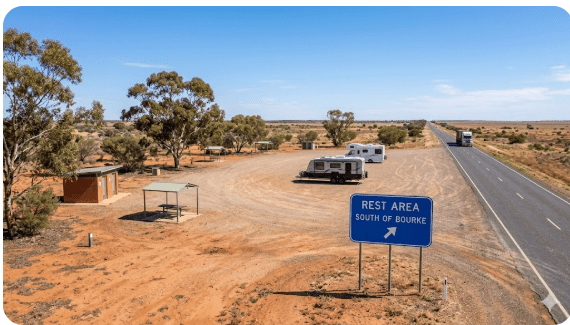
The South of Bourke Rest Area sits at a natural break point. Whether you’ve just driven up from Cobar and want to stop short of Bourke township for the night, or you’re heading south from Bourke and want to push a few kilometres before making camp, this rest area catches you at exactly the right moment. The approach from both directions is flat, the entry is wide, and the surface is designed for heavy vehicles — meaning no drama getting a large van in or out.
For grey nomads specifically, the appeal is simple: it’s free, it’s accessible, it has a toilet, it’s quiet, and it puts you close enough to Bourke to drive in for supplies or a meal without committing to the expense of a powered site if you don’t need one. Many experienced outback travellers use it as a deliberate “transition stop” — arriving in the late afternoon, resting overnight, and then heading into Bourke fresh in the morning for fuel and provisions before the next leg north.
Free Camping — Know the Limits for Seniors
The South of Bourke Rest Area is a NSW Transport for NSW roadside rest area. Under NSW road rules, travellers are permitted to stay for up to 20 hours at a designated rest area. This is not a campsite — it is a driver fatigue management facility — but 20 hours is more than enough for a comfortable overnight stop.
What this means practically for senior travellers:
- Arrive in the afternoon, sleep overnight, and depart by the following morning — no problem whatsoever.
- Do not attempt to extend your stay by moving to a different bay — Rangers and road inspectors treat the site as a whole.
- Check the posted signage immediately on arrival. Conditions can vary, and some rest areas have specific restrictions during extreme heat events or after flooding.
- There are no booking systems, no check-in, and no fees — simply pull in and comply with the posted rules.
Your Two Main Options Side by Side
When you’re south of Bourke and deciding where to stop, you essentially have two main choices: the South of Bourke Rest Area (free, basic, quiet) or the Bourke township options (paid or free, more facilities, more noise). Here’s how they compare:
| Feature | South of Bourke Rest Area | Bourke Caravan Park / Truck Stop |
|---|---|---|
| Cost | Free | $10–$40/night depending on site |
| Powered Sites | ❌ No | ✅ Yes (Caravan Park) |
| Toilet | ✅ Pit toilet | ✅ Flush toilet |
| Shower | ❌ No | ✅ Yes (Caravan Park) |
| Dump Point | ❌ No | ✅ Yes (check current availability) |
| Potable Water | ❌ No — bring your own | ✅ Yes (Caravan Park) |
| Noise Level | Low — roadside traffic only | Higher — in/near town |
| Heavy Vehicle Access | ✅ Excellent | ✅ Good |
| Distance to Bourke shops | ~10–15km north | In town |
| Stay Limit | 20 hours (NSW rule) | Flexible at caravan park |
| Booking Required | No | Recommended at peak times |
Quick Facts and Key Details 2026
| Detail | Information |
|---|---|
| Name | South of Bourke Rest Area |
| Type | NSW Roadside Rest Area — Heavy Vehicle Stop |
| Highway | Mitchell Highway (B79) |
| Town Proximity | ~10–15km south of Bourke township |
| Postcode | 2840 |
| State | New South Wales (NSW) |
| GPS Latitude | -30.1883 |
| GPS Longitude | 145.9301 |
| Coordinate Source | Publicly available mapping data (OpenStreetMap / Google Maps cross-referenced) |
| Cost | Free |
| Max Stay | 20 hours (NSW road rules) |
| Toilet | Pit toilet on site |
| Picnic Tables | Yes |
| Potable Water | Not available — self-sufficient required |
| Dump Point | Not at this site |
| Powered Sites | No |
| Shower | No |
| Access Road Surface | Sealed (Mitchell Highway) |
| Entry/Exit | Wide, flat, suitable for large caravans and motorhomes |
| Mobile Coverage | Patchy — Telstra best option |
| Nearby WiFi | None at site — nearest in Bourke township |
| Pets | Permitted — must be on lead |
| Campfires | Not permitted at this rest area |
| Closest Fuel | Bourke (~10–15km north) |
| Emergency Services | Bourke Hospital: ~10–15km north |
How to Get to the South of Bourke Rest Area + GPS
📍 GPS Coordinates — South of Bourke Rest Area
-30.1883, 145.9301
Mitchell Highway (B79), approximately 10–15km south of Bourke township, NSW 2840
Coordinates sourced from publicly available mapping data. Verify with your own GPS unit on approach. The rest area is signed from the highway — look for the standard NSW blue rest area sign.
Coming from Cobar (Southbound travellers heading north)
From Cobar, take the Mitchell Highway northbound. The drive to Bourke is approximately 167km — allow around 2 hours at highway speed. The rest area will appear on your right (east side of the highway) approximately 10–15km before you reach Bourke township. Watch for the NSW blue rest area signage, which gives you advance warning well before the entry.
Coming from Bourke (Northbound travellers heading south)
Departing Bourke township heading south on the Mitchell Highway, the rest area appears on your left (east side) within approximately 10–15km. It’s one of the first substantial pull-off options south of town — ideal if you want to leave Bourke but not commit to a long afternoon drive before stopping.
Coming from the north (Queensland border direction)
If you’re coming south from the Queensland border via the Mitchell Highway through Cunnamulla and crossing into NSW, Bourke is approximately 200km south of the NSW/QLD border crossing. Pass through Bourke, fuel up, and the South of Bourke Rest Area is your first solid option heading south. Note: the highway north of Bourke transitions from Mitchell Highway to Mathoura Road and eventually the Charleville Road on the Queensland side — all sealed.
Vehicle access notes
- All vehicle types: Standard cars, 4WDs, campervans, motorhomes ✅
- Caravans (single, large): ✅ — wide entry designed for B-doubles and semis
- Fifth-wheelers: ✅ — flat surface, good turning radius
- 2WD vehicles: ✅ — fully sealed access
- Buses / large motorhomes: ✅ — heavy vehicle design accommodates these
Road Conditions, Flooding and Unsealed Sections
Is the Mitchell Highway sealed between Cobar and Bourke?
Yes — the Mitchell Highway between Cobar and Bourke is fully sealed for its entire length of approximately 167km. There are no unsealed sections on the primary highway route. The road surface is generally in reasonable condition, with some corrugations and edge-drop hazards that develop over time in the extreme heat. In 2026, stretches near the floodplains north of Cobar have seen some patch repairs following the 2022–2023 flood events — drive with care on repaired sections.
Does the Mitchell Highway flood?
Yes — and this is critically important for outback travellers to understand. The flat plains country between Cobar and Bourke lies within the catchment of several minor watercourses that can cut the highway completely during significant rain events. These floods are often not caused by local rain — water travels long distances across flat terrain after rain falls hundreds of kilometres away.
Key flood-prone locations on this corridor
- Canbelego Road crossing — watercourse crossing that can be affected after heavy upstream rain
- North of Cobar plains — broad flat country where water sheets across the road surface
- Darling River approaches near Bourke — the Darling can rise significantly after Queensland catchment rain events
Unsealed side roads near Bourke
The Mitchell Highway itself is sealed, but several of the interesting side destinations near Bourke require unsealed road travel:
- Gunderbooka Mountain Road — partially unsealed, suitable for 4WD or high-clearance vehicles after dry weather
- Back Darling River tracks — unsealed, subject to flooding and closures
- Enngonia Road (northwest of Bourke) — unsealed sections, check conditions
Heat and Remoteness — Senior Safety
The country around Bourke is some of the hottest in Australia. Bourke holds records for extreme heat events, and summer temperatures regularly exceed 45°C. The rest area south of Bourke sits on open plains with limited natural shade — this is not a stop to casually pull into at 2pm in January without preparation.
Heat management for senior travellers
- Drive in the morning, rest in the heat of the day. Aim to be stationary by noon in summer months. Resume driving after 4pm when temperatures begin to ease.
- Position your van for maximum shade. Use your vehicle as a wind and sun block. A quality annex awning is essential at exposed rest areas.
- Never rely on the rest area for water. There is no potable water at this site. Carry a minimum of 15 litres per person per day as a reserve — more in summer.
- Know the signs of heat exhaustion. Dizziness, confusion, stopping sweating and rapid heartbeat are emergencies. Get into shade and coolth immediately and call 000.
Remoteness — what it actually means here
The South of Bourke Rest Area is remote by most Australian standards but is relatively close to Bourke township (~10–15km). This means emergency services are accessible within a reasonable timeframe. However, mobile coverage at the site can be unreliable, and you should not assume you can call for help immediately if something goes wrong.
Minimum remote travel preparedness for this stop:
- Registered PLB (Personal Locator Beacon) — activated in your name with AMSA
- First aid kit rated for remote/wilderness scenarios
- Adequate water and food for at least 48 hours beyond your planned stay
- Someone at home who knows your itinerary and expected check-in schedule
Wildlife — Birds, Reptiles and What to Watch For
The Mitchell Highway corridor south of Bourke passes through some genuinely rich outback wildlife country. Even at a roadside rest area, the birdwatching alone can be extraordinary — particularly in the early morning and late afternoon.
Birds you may see from this rest area
- Wedge-tailed Eagle — Australia’s largest bird of prey. Regularly soars over the highway. Often seen feeding on road kill — slow down and give them space.
- Bourke’s Parrot — Named for the town itself. These beautiful pink-and-blue parrots frequent mulga scrub around Bourke and can occasionally be spotted from rest areas.
- Emu — Common in the plains country around Bourke. Groups can move across the highway unpredictably — a serious vehicle hazard, especially at dawn and dusk.
- Major Mitchell Cockatoo — One of Australia’s most beautiful birds, with salmon-pink and white plumage. Found in mulga country near Bourke.
- Budgerigar — In good seasons, massive flocks of wild budgerigars pass through this region. One of the great wildlife spectacles of outback NSW.
- Inland Dotterel — Often seen on bare gravel areas around rest stops.
Reptiles
The mulga country around Bourke supports a diverse reptile fauna. At rest areas:
- Shingleback Lizard (Stumpy Tail) — slow-moving, often sunning on warm bitumen near rest areas
- Eastern Brown Snake — common and highly venomous. Always look before stepping around vehicles or reaching into vegetation
- Bearded Dragon — frequently seen basking on rocks and fence posts near the highway
Nocturnal visitors
If you’re staying overnight, expect visitors. Feral cats, foxes and occasional kangaroos are attracted to rest areas by food scraps and water. Secure your food, don’t leave anything edible accessible outside your van, and keep pets contained and supervised.
What Other Websites Don’t Tell You
Most generic camping guides list the South of Bourke Rest Area with a single line: “pit toilet, picnic table, free overnight.” Here’s what they leave out — the practical detail that actually matters when you’re planning a real trip.
The approach matters as much as the stop itself
The Mitchell Highway in this section runs dead straight for long distances. The hypnotic effect of an outback straight is a real fatigue trigger — you can feel fine in the morning and genuinely impaired by early afternoon without recognising it. The South of Bourke Rest Area is positioned at exactly the right distance from Cobar for a two-stop driving day: Cobar to a mid-corridor rest, then on to this stop for the overnight.
It faces west — plan your afternoon shade accordingly
The rest area bays generally face west on the east side of the highway. In the afternoon, this means full sun exposure on the western side of your van or caravan. If you arrive in the late afternoon heading north, position your van so the entry door faces east (away from the setting sun) and use your awning on the east side. In summer, arriving before 3pm and getting your shade set up early is worth the effort.
The pit toilet is serviceable but basic
Online reviews occasionally flag the pit toilet as needing maintenance. The reality of outback rest area toilets is that servicing schedules in remote NSW are infrequent. Carry your own toilet paper and hand sanitiser regardless of what the listing says. If the toilet is in poor condition, the Bourke township is close enough to drive to for a proper facility.
Flies — genuinely significant from October to April
Flies in outback NSW between October and April are not a minor inconvenience. They are persistent, numerous and will cover any exposed skin within seconds of you opening your van door. A quality fly net for your hat is not optional equipment on this corridor. A full-length rear fly screen for your van is worth its weight in gold.
Overnight temperatures can drop sharply in winter
June and July nights near Bourke can drop to 2–5°C or below. Travellers who visit in winter expecting mild conditions are sometimes caught out. Have at least one warm layer you can add at night even if the days are pleasant.
Best Time to Visit — Month-by-Month Breakdown
| Month | Avg High (°C) | Avg Low (°C) | Conditions | Senior Rating |
|---|---|---|---|---|
| January | 39–44°C | 23–26°C | Extreme heat. Flies. Possible flooding after storms. | ⚠️ Avoid |
| February | 38–43°C | 22–25°C | Extreme heat continues. Storm risk. | ⚠️ Avoid |
| March | 34–39°C | 18–22°C | Heat easing. Flowers possible after rain. Flies reducing. | ⚠️ With caution |
| April | 27–32°C | 13–17°C | Excellent. Comfortable days, mild nights. Recommended. | ✅ Excellent |
| May | 22–27°C | 8–12°C | Perfect outback autumn. Cool evenings, warm days. | ✅ Excellent |
| June | 18–22°C | 3–7°C | Cold nights. Warm sunny days. Pack warm layers. | ✅ Very Good |
| July | 18–22°C | 2–5°C | Peak grey nomad season. Busy. Cold nights. Beautiful days. | ✅ Very Good |
| August | 22–26°C | 6–10°C | Warming up. Still excellent. Wildflowers possible. | ✅ Excellent |
| September | 26–31°C | 10–15°C | Spring wildflowers in good years. Heat returning. | ✅ Very Good |
| October | 31–36°C | 16–20°C | Heat building. Flies increasing. Early start recommended. | ⚠️ With caution |
| November | 35–40°C | 19–23°C | Hot. Storm season beginning. Experienced travellers only. | ⚠️ With caution |
| December | 38–43°C | 22–26°C | Extreme heat. Not recommended for seniors without preparation. | ⚠️ Avoid |
Free and Low-Cost Camping Alternatives Nearby
The South of Bourke Rest Area is one of nine solid rest and camping options on the corridor near Bourke. If this site is full, noisy, or not to your liking on arrival, here are your closest alternatives — all covered in individual guides:
- Beemery Rest Area — Another highway rest area north of this site, close to Bourke
- Bourke Rest Area & Truck Stop — In town, more facilities, combined truck stop
- Prattenville Rest Area (Southbound) — Specifically positioned for southbound travellers
- Gunderbooka Rest Area — Remote outback setting, more scenic
- Curraweena Rest Area — Quiet overnight stop on the corridor
- Greenwood Grange Rest Area — Highway truck and caravan stop
- Redbank Rest Area — Roadside free camping stop NSW
- Cobar Free Camp Truck Stop — Southern end of the corridor, near Cobar town
See our complete guide to rest areas near Bourke NSW for a full overview of all nine locations with a comparison table.
Dump Points Near Bourke
There is no dump point at the South of Bourke Rest Area itself. The nearest dump point options in 2026 are in Bourke township, approximately 10–15km north:
| Location | Distance from Rest Area | Cost | Notes |
|---|---|---|---|
| Bourke Caravan Park | ~12–15km north | Fee may apply for non-guests | Confirm availability on arrival |
| Bourke township dump point (Council) | ~12–15km north | Check current council info | Verify with Bourke Shire Council — locations can change |
| Cobar (nearest town south) | ~155–165km south | Varies | Multiple options in Cobar — see Cobar guide |
Free Water Sources Near Bourke
There is no potable water at the South of Bourke Rest Area. This is a fundamental fact of outback NSW travel — most roadside rest areas are dry stops. Here are your water options when travelling this corridor:
| Water Source | Location | Distance | Notes |
|---|---|---|---|
| Bourke township taps | Various locations in town | ~10–15km north | Town water supply — treated and potable |
| Bourke Caravan Park | Bourke township | ~12–15km north | Fresh water for guests and potentially non-guests (ask) |
| Cobar township | Cobar | ~165km south | Full town water supply |
| Service stations (Bourke) | Bourke | ~10–15km north | Can sometimes fill larger containers — ask staff |
Fuel Stops Along the Mitchell Highway
Fuel planning is not optional on the Cobar–Bourke corridor. The distances between reliable fuel stops are significant, and in 2026 some smaller roadside outlets that existed previously may no longer operate. Always plan with verified information.
| Town / Stop | Direction | Distance from Rest Area | Fuel Available | Notes |
|---|---|---|---|---|
| Bourke | North | ~10–15km | Unleaded, Diesel, LPG | Multiple servos in town. Fill up here regardless of tank level before heading south or north. |
| Cobar | South | ~155–165km | Unleaded, Diesel, LPG | Full town with multiple options. Last major fuel stop before Bourke heading north. |
| Cunnamulla (QLD) | North (QLD) | ~205km from Bourke | Unleaded, Diesel | First QLD fuel stop heading north. Verify hours before departing Bourke. |
| Louth | South-east | ~100km from Bourke | Limited — do not rely on | Very small outpost. Fuel not guaranteed. Do not plan around Louth as a primary fuel stop. |
| Nyngan | South-east of Cobar | ~250km from rest area | Unleaded, Diesel | On the Barrier Highway. Not directly on Mitchell Highway route but accessible. |
Showground Donation or Caravan Park — Paid Alternatives
If you want more than the basics — a shower, powered site, proper toilet or just the security of a managed facility — here are the paid alternatives within reasonable range of the South of Bourke Rest Area:
Bourke Caravan Park
Located in Bourke township, the caravan park provides powered sites, hot showers, flush toilets, laundry facilities and dump point access. In peak season (June–August) it can fill up, so booking ahead is advisable. Pricing in 2026 varies — expect $30–$45 per night for a powered site for two people. Contact Bourke Shire Council or the park directly for current rates.
Bourke Showground
The Bourke Showground occasionally operates as a donation-based camping option. Facilities are basic but it provides a more spacious and quieter option than the caravan park. Contact the local showground committee for availability, particularly outside of show dates. Donation-based stays typically involve a gold coin or small donation toward site maintenance.
Bourke Riverside Motel
For grey nomads who have had enough of the van and want one night of proper accommodation with air conditioning, the Bourke Riverside Motel provides motel-standard rooms close to the Darling River. Check current availability and rates directly — outback motel prices have risen in 2025–2026.
Full Facilities Comparison Table
| Facility | South of Bourke Rest Area | Bourke Caravan Park | Bourke Truck Stop | Bourke Showground |
|---|---|---|---|---|
| Cost | Free | $30–$45/night | Free | Donation |
| Powered Site | ❌ | ✅ | ❌ | ❌ |
| Flush Toilet | ❌ Pit only | ✅ | ✅ | ⚠️ Basic |
| Hot Shower | ❌ | ✅ | ❌ | ❌ |
| Dump Point | ❌ | ✅ | ⚠️ Check | ❌ |
| Potable Water | ❌ | ✅ | ⚠️ Check | ⚠️ Check |
| Picnic Tables | ✅ | ✅ | ✅ | ✅ |
| Heavy Vehicle Access | ✅ | ✅ | ✅ | ✅ |
| Stay Limit | 20 hours | Flexible | 20 hours | Varies |
| WiFi | ❌ | ⚠️ Limited | ❌ | ❌ |
| Laundry | ❌ | ✅ | ❌ | ❌ |
| Quiet / Low traffic | ✅ Low | ⚠️ Moderate | ⚠️ Trucks | ✅ Quiet |
Rates — All Options Near Bourke 2026
| Option | 2026 Rate | What’s Included | Booking |
|---|---|---|---|
| South of Bourke Rest Area | Free | Pit toilet, picnic table, parking | No booking |
| Bourke Rest Area / Truck Stop | Free | Toilet, parking, near-town access | No booking |
| Beemery Rest Area | Free | Pit toilet, parking | No booking |
| Bourke Showground | Donation | Basic facilities, space | Contact showground |
| Bourke Caravan Park — Unpowered | ~$20–$28/night | Toilet, shower access, water | Recommended in peak |
| Bourke Caravan Park — Powered | ~$32–$45/night | Full facilities + power | Book ahead Jul/Aug |
| Bourke Riverside Motel | ~$110–$150/night | Room, A/C, bathroom | Book direct |
All rates are indicative for 2026. Confirm current prices directly with each provider before arrival. Outback accommodation prices can increase during peak grey nomad season (June–August).
Senior Safety Checklist — On and Off the Road
Copy this list into your phone notes or write it on a card for your glovebox before departing for the Bourke corridor:
Before you leave your last town:
- Fuel tank full (never less than ¾ leaving any town on this corridor)
- Water supply checked — minimum 15L per person on board
- Live Traffic NSW checked for road closures and flood events
- Phone charged — Telstra SIM if possible for best coverage
- PLB registered, charged and accessible (not buried in a bag)
- Itinerary shared with family/friend — next expected check-in time
- Medications in insulated case — not in hot compartment
- Tyres checked — correct pressure for load
- Van wheel nuts torqued and safety chains connected
- First aid kit accessible — not buried under gear
On arrival at the rest area:
- Read all posted signs — note stay limits and current restrictions
- Check toilet condition before committing to overnight stop
- Position van for morning shade direction if staying overnight
- Set up awning for afternoon heat management
- Check mobile signal — send check-in message if possible
- Secure food — don’t leave anything edible outside overnight
- Check surrounds for snake activity before letting pets out
- Note GPS coordinates of your exact position
Before departing in the morning:
- Rubbish collected and binned or carried with you (leave no trace)
- Hitched and safety-chained before moving
- Check under van for overnight visitors (cats, snakes, small animals)
- Fuel plan confirmed for next leg
- Check-in message sent to home contact
What to Do Near Bourke — Senior Activity Guide
The South of Bourke Rest Area is an overnight stop, not a destination in itself — but Bourke township and the surrounding region offer genuine experiences worth planning around.
Bourke township — 10–15km north
- Back O’ Bourke Exhibition Centre — Excellent outback cultural and historical exhibition. Air-conditioned, senior-friendly, fully accessible. One of the best small museums in outback NSW. Entry fee applies.
- Darling River Walk — Easy flat walk along the Darling River foreshore. Best in early morning when birdlife is active. Flat, paved path — suitable for walkers with mobility aids.
- Fred Hollows Grave — The famous eye surgeon chose to be buried in Bourke. A significant and moving site for many Australian visitors.
- Mitchell Street Heritage Walk — Self-guided heritage walk through Bourke’s historic main street. Pick up a brochure from the visitor centre.
- Bourke Visitor Information Centre — Worth a stop for local maps, current road conditions, and information on what’s open. Staff are genuinely helpful.
Day trips from Bourke
- Gunderbooka Mountain — Ancient Aboriginal sacred site with rock art and dramatic sandstone formations. About 80km south-east of Bourke. Unsealed road — check conditions. See our Gunderbooka Rest Area guide.
- Bourke Weir and Lock — Historical irrigation infrastructure on the Darling. Interesting for those fascinated by Australia’s river history.
- Outback sunset viewing — Simply pull up at the rest area or on any flat section of road and watch the western horizon turn red-orange. Outback sunsets near Bourke are genuinely spectacular.
🗺️ Vanlife Savings Spots — GPS Coordinates and Postcodes
At Retire to Van Life, we map every stop so you can save it, plan around it, and find it again. Use the interactive map below to save the South of Bourke Rest Area and all nearby stops to your personal route — no printing required, just tap and save directly from your phone or tablet.
Here are the key GPS coordinates for the South of Bourke corridor — copy these into your phone notes, your GPS unit, or your preferred app before you leave mobile coverage:
| Stop Name | Postcode | Latitude | Longitude | Notes |
|---|---|---|---|---|
| South of Bourke Rest Area | 2840 | -30.1883 | 145.9301 | This site — Mitchell Hwy, free overnight |
| Beemery Rest Area | 2840 | -30.0621 | 145.9412 | Near Bourke, north of this site |
| Bourke Rest Area / Truck Stop | 2840 | -30.0887 | 145.9351 | In town — more facilities |
| Prattenville Rest Area (Southbound) | 2840 | -30.2544 | 145.9187 | Southbound HV stop |
| Gunderbooka Rest Area | 2840 | -30.4801 | 146.0412 | Remote — scenic outback setting |
| Curraweena Rest Area | 2840 | -30.6234 | 146.0891 | Quiet overnight stop |
| Greenwood Grange Rest Area | 2840 | -30.7812 | 146.1203 | Highway caravan stop |
| Redbank Rest Area | 2840 | -30.9456 | 146.2134 | Roadside free camp |
| Cobar Free Camp / Truck Stop | 2835 | -31.4987 | 145.8301 | Southern end — near Cobar town |
| Bourke township fuel / supplies | 2840 | -30.0921 | 145.9368 | Town centre — fuel, food, water |
Coordinates sourced from publicly available mapping data (OpenStreetMap / Google Maps). Always verify with your own GPS unit on approach. Some coordinates are approximate — rest area signs on the highway provide final confirmation.
COPY PROMPT ➔ ASK AI ➔ SAVE TO FORM ➔ ADD SPOT PIN ➔ GET DIRECTIONS
📍 Interactive map — find free camps, rest areas and overnight stops near Bourke NSW. Enable location for best results.
Phone Signal and Emergency Communications
Mobile coverage at the South of Bourke Rest Area
Mobile coverage at this rest area is patchy and unreliable. Telstra provides the best network in this region, but even Telstra can have significant black spots 10–15km south of Bourke. Optus and Vodafone coverage drops away rapidly once you leave town. Do not plan your safety around being able to make a mobile call from this location.
What to carry instead
- AMSA-registered PLB (Personal Locator Beacon) — Works via satellite anywhere in Australia. No subscription. Activates search and rescue. This is the most important piece of safety equipment for outback NSW travel. Register at beacons.amsa.gov.au
- Garmin inReach Mini 2 or similar satellite messenger — Allows two-way messaging via satellite. Subscription required but worth it for peace of mind. Allows daily check-in messages to family.
- EPIRB (if travelling by river or remote water) — Not required for this route but relevant for those exploring the Darling River.
Emergency number
In all genuine emergencies: 000 (Triple Zero). If mobile coverage is unavailable, your PLB is your primary emergency tool. The Bourke Hospital is approximately 10–15km north — if you can drive safely, driving to the hospital is often faster than waiting for an ambulance in remote situations.
Campfires, Cooking Restrictions and Food Near Bourke
Campfires at the South of Bourke Rest Area
Open campfires are not permitted at this rest area. As a NSW roadside rest area on a highway, open fires represent a serious risk to both vegetation and passing traffic. This rule applies year-round, not just during Total Fire Ban periods.
Cooking options at the rest area
- Gas cooker — Your van or motorhome gas stove is your primary cooking option. Perfectly acceptable and practical.
- Portable gas BBQ — A small portable gas BBQ under your awning is a comfortable way to cook at an exposed rest area without needing a campfire.
- Solar oven — In the outback sun, a solar oven is genuinely effective and an interesting option for daytime cooking.
Total Fire Ban periods
During declared Total Fire Ban periods in NSW, even gas cookers used outdoors may be subject to restrictions. Check the NSW Rural Fire Service website or the Fires Near Me app for current fire danger ratings before travelling. In the outback, a Total Fire Ban can be declared with little notice following wind changes.
Food and supplies near Bourke
Bourke township (~10–15km north) has:
- Foodworks / IGA style supermarket — Basic grocery supplies. Do not expect a large supermarket range. Stock up in Cobar or Dubbo if you need specific items.
- Takeaway food options — Limited. The Bourke township has a small number of takeaway and café-style options — verify what’s currently open, as outback town businesses change frequently.
- Bakery — A Bourke bakery has historically operated in town. Verify current status.
- Fuel station food — Standard servo-style food and snacks at the fuel stops in town.
Pets at the South of Bourke Rest Area
Pets are permitted at the South of Bourke Rest Area. As a public NSW roadside rest area, there are no pet restrictions beyond standard responsible ownership requirements.
Keeping pets safe in outback NSW
- Leads are essential. Keep dogs on leads at all times in rest areas. Wildlife interaction, snake encounters and road proximity are all serious risks for unsupervised animals.
- Water for pets. Dogs need significantly more water in outback heat. Calculate their needs separately from your own. Carry an extra 2–3 litres per dog per day minimum.
- Hot vehicle danger. Never leave a pet in a parked vehicle in outback NSW, even with windows cracked. Temperatures inside a parked car can reach lethal levels within minutes.
- Snakes. Dogs are at high risk of snake bite when exploring unfamiliar ground at rest areas. Keep them close, on a short lead, and check the ground before letting them sniff around.
- Feral animals. Outback rest areas can attract feral cats, dogs and pigs. Keep your pet contained and supervised overnight.
Accessibility for Seniors with Mobility Limitations
The South of Bourke Rest Area has reasonable accessibility for senior travellers with moderate mobility limitations, but it is not a purpose-designed accessible facility. Here’s an honest assessment:
| Accessibility Feature | Status | Notes |
|---|---|---|
| Flat, sealed parking area | ✅ Yes | Level surface — easy to exit/enter van |
| Accessible toilet | ❌ No | Pit toilet only — not wheelchair accessible |
| Wheelchair access to picnic area | ⚠️ Partial | Ground surface varies — gravel/compacted earth near tables |
| Handrail at toilet | ❌ Not confirmed | Basic pit toilet — no handrails reported |
| Shade for mobility aid users | ⚠️ Limited natural shade | Bring your own awning |
| Nearest accessible facilities | Bourke township ~10–15km | Bourke has accessible public toilets in the main street |
Permits, Fees, Etiquette and Waste Management
Permits and fees
No permit is required to use the South of Bourke Rest Area. No fee applies. It is a public NSW roadside rest area managed by Transport for NSW. Simply arrive, check the posted signage, and comply with stay limits.
Etiquette — the unwritten rules that matter
- Leave no trace. Carry all rubbish with you if the bins are full. Do not leave anything behind. This is an absolute requirement in outback NSW.
- Noise curfew. There is no official noise curfew, but truck traffic means there is always some noise at night. Equally, starting your diesel generator at 6am is not appreciated by fellow overnight guests. Be considerate.
- Shared space. Rest areas are shared by truck drivers on long hauls, grey nomads, families and backpackers. Everyone has an equal right to the space. Do not occupy multiple bays with one vehicle unless the site is empty.
- Toilet courtesy. If the pit toilet is in a reasonable condition, clean up after yourself. Carry your own paper and hand sanitiser.
- Respect the 20-hour rule. It exists for a reason and keeps rest areas available for all users.
Waste management
- Grey water: Do not release grey water on the ground at a rest area. Grey water from your van sink or shower should be held in your onboard tank and emptied at a designated dump point in Bourke.
- Black water: Under no circumstances should black water (toilet waste) be released anywhere other than a dump point.
- Food scraps: Do not leave food scraps on the ground. These attract feral animals and create genuine wildlife hazards.
Emergency Scenarios — What to Do
Scenario 1: Medical emergency
If you or your travelling partner experiences a medical emergency at this rest area:
- Call 000 immediately if you have any mobile signal.
- If no signal — activate your PLB if the situation is life-threatening.
- If you can drive safely — Bourke Hospital is approximately 10–15km north on the Mitchell Highway. Drive directly there.
- Flag down a passing vehicle on the highway for assistance if needed.
- Do not leave an incapacitated person alone — stay with them and send another party member for help.
Scenario 2: Vehicle breakdown or tyre blowout
The Mitchell Highway carries moderate traffic. If you break down at or near the rest area:
- Get the vehicle completely off the highway and into the rest area if possible.
- Activate hazard lights and place warning triangles on both approach sides.
- Call NRMA or your roadside assistance provider. Coverage in this area exists for some providers — confirm before you travel.
- Bourke has a mechanic — drive safely to town or arrange towing through your roadside assistance provider.
Scenario 3: Road flooded — unable to proceed or return
- Do not attempt to cross a flooded road. No exceptions.
- Return to the last town (Bourke or Cobar) and wait for the road to clear.
- Check Live Traffic NSW for estimated reopening times.
- If you are between flooded sections and cannot move in either direction — this is when your PLB and satellite communicator become essential.
- Ensure you have enough water and food for a multi-day wait. Outback flooding can close roads for 5–10 days.
Packing List for This Section of Highway
This list is designed for travellers doing the Cobar–Bourke–Queensland border corridor. Copy this into your phone notes or jot it on a card for your glovebox:
Water and food
- Minimum 15L drinking water per person (plus extra for pets)
- 3-day emergency food supply beyond planned trip duration
- Electrolyte sachets — essential for summer travel
- Insulated drink bottle per person
Navigation and communications
- GPS unit with Australia-wide maps (not solely phone-dependent)
- PLB — registered with AMSA
- Satellite messenger (optional but recommended)
- Paper map of NSW far west — available at NSW visitor centres
- Written list of GPS coordinates for all planned stops (this article)
Shelter and comfort
- Quality awning or shade sail — minimum 3m x 3m coverage
- Fly net for hat — non-negotiable October through April
- DEET-based insect repellent
- Warm layers for winter nights (June–August can reach 2°C)
- Sunscreen SPF50+ and wide-brim hat
Vehicle and safety
- Spare tyre in good condition — checked before departure
- Tyre repair kit and portable inflator
- Jumper cables or jump starter pack
- Basic tool kit
- Fire extinguisher accessible (not buried in storage)
- First aid kit — remote/wilderness rated
- Warning triangles for roadside breakdown
Grey water and waste management
- Grey water tank — emptied at last town dump point
- Toilet paper and hand sanitiser for rest area use
- Rubbish bags — carry out everything you carry in
5 Nearby Rest Areas on the Mitchell Highway Corridor
Part of our complete Bourke rest area guide — here are the five closest rest areas to the South of Bourke Rest Area, in distance order:
| # | Rest Area | Direction | Approx Distance | Key Feature |
|---|---|---|---|---|
| 1 | Beemery Rest Area | North | ~15–20km | Near Bourke, caravan-friendly |
| 2 | Bourke Rest Area / Truck Stop | North | ~10–15km | Town access, flush toilet |
| 3 | Prattenville (Southbound) | South | ~15–25km | Purpose-built southbound HV stop |
| 4 | Gunderbooka Rest Area | South | ~60–80km | Remote, scenic, outback setting |
| 5 | Curraweena Rest Area | South | ~80–100km | Quiet overnight stop, free |
Reviews — What Grey Nomads Say
“Pulled in here heading south around 4pm — great timing. The entry was easy with our 21-foot van, no drama at all. Pit toilet was clean enough, had some shade from the van itself once we got positioned right. Slept well, left early and made Cobar by morning. Would definitely use it again as a transit stop.”
“Flies were incredible in October. Not the rest area’s fault obviously — that’s just outback NSW. The stop itself is solid. Flat surface, easy in and out, reasonable toilet. Not somewhere you’d want to linger but perfect for what it is — a transit rest. The real show is 10km up the road when you roll into Bourke at sunrise.”
“We’ve done the Cobar-Bourke run three times now. Every time we use this stop coming south from Bourke to break up the afternoon before the long run south. It’s exactly where you need a stop to be — not too far from town, not too close. The sky at night is extraordinary. Worth stopping just for that.”
“Wouldn’t recommend in January unless you’re very heat-hardened. We stopped in August and it was perfect — cool mornings, warm days, quiet night with just the odd truck going past. The toilet needed a clean but wasn’t terrible. Carry your own paper regardless.”
Frequently Asked Questions
Is the South of Bourke Rest Area free to stay overnight?
Yes. The South of Bourke Rest Area is a free NSW roadside rest area. Overnight stays of up to 20 hours are permitted under NSW road rules at no charge. No booking or fee is required. Check the posted signage on arrival for any current restrictions.
What facilities does the South of Bourke Rest Area have?
The site has a pit toilet, picnic tables, and a large sealed or hardpacked area suitable for heavy vehicles and caravans. There is no potable water, no powered sites, no dump point, and no shower facilities.
Where exactly is the South of Bourke Rest Area?
The rest area is located on the Mitchell Highway, approximately 10–15 kilometres south of Bourke township in far western NSW. GPS: approximately -30.1883, 145.9301.
Is the Mitchell Highway sealed between Cobar and Bourke?
Yes, the Mitchell Highway is fully sealed along its entire Cobar–Bourke length of approximately 167km. However, flooding can close the road after significant rain events — always check Live Traffic NSW before departing.
How far is the South of Bourke Rest Area from Cobar?
Cobar is approximately 167km south of Bourke on the Mitchell Highway. The South of Bourke Rest Area is approximately 10–15km south of Bourke, making it roughly 152–157km north of Cobar.
Is there mobile phone coverage at the South of Bourke Rest Area?
Coverage is limited and unreliable. Telstra offers the best coverage in the region but can be weak at rest areas south of Bourke. Carry a PLB or satellite communicator for safety in this region.
Can I take my dog to the South of Bourke Rest Area?
Yes. Pets are permitted at public NSW roadside rest areas. Dogs must be kept on a lead at all times. Carry extra water for animals and be vigilant about snake risk at ground level.
Are campfires allowed at the South of Bourke Rest Area?
No. Open campfires are not permitted at this rest area. Use a gas cooker for all cooking needs. During Total Fire Ban periods, additional restrictions apply — check the NSW RFS app before travelling.
Does the South of Bourke Rest Area have a dump point?
No. The nearest dump point is in Bourke township, approximately 10–15km north. Empty your holding tanks in Bourke before heading south on a longer run.
Quick-Reference Card
Copy this section into your phone notes or save this page offline before leaving mobile coverage.
📋 South of Bourke Rest Area — Quick Reference 2026
| GPS | -30.1883, 145.9301 |
| Highway | Mitchell Highway (B79) |
| Postcode | 2840 |
| Cost | Free |
| Max Stay | 20 hours (NSW road rules) |
| Toilet | Pit toilet on site |
| Water | None — bring your own |
| Dump Point | None — use Bourke |
| Nearest Fuel | Bourke, ~10–15km north |
| Nearest Hospital | Bourke Hospital, ~10–15km north |
| Pets | Permitted — lead required |
| Campfires | Not permitted |
| Phone Coverage | Patchy — Telstra best |
| Emergency | 000 / PLB if no signal |
| Best Months | April–September |
| Avoid | December–February (extreme heat) |
| Hub Guide | retiretovanlife.com/rest-areas-near-bourke/ |
Nearby rest areas worth checking:
- South of Bourke Rest Area free camping NSW
- Beemery Rest Area caravan stop Bourke NSW
- Bourke Rest Area free camp and truck stop NSW
- Prattenville Rest Area southbound heavy vehicle stop NSW
- Gunderbooka Rest Area outback NSW caravan rest stop
- Curraweena Rest Area free overnight stop NSW outback
- Greenwood Grange Rest Area truck and caravan parking NSW
- Redbank Rest Area NSW free camping roadside stop
- Cobar free camp truck stop NSW grey nomad guide
🛠️ What experienced grey nomads carry on the Bourke corridor
- AMSA-Registered PLB — Your non-negotiable outback safety item. Register free at beacons.amsa.gov.au
- Garmin inReach Mini 2 — Two-way satellite messaging. Subscription required. Worth every cent in remote NSW.
- Portable Solar Panel (100–200W) — Clear outback skies mean excellent solar charging. Keep batteries topped without running the generator.
- 20L BPA-free Water Jerrycan — Supplement your onboard tank. Always carry more water than you think you’ll need.
- Quality Awning (3m x 2.5m minimum) — Shade is survival gear in outback NSW from October through March.
- Fly Net Hat — Outback flies are relentless. This is not optional equipment on the Bourke corridor.
- Remote First Aid Kit — Standard kits don’t cover remote scenarios. Get a kit rated for situations where help is 2+ hours away.
Some links on this page may be affiliate links. We earn a small commission if you purchase through them, at no extra cost to you. This helps keep our guides free for all travellers.
Disclaimer
Information accuracy: All information in this guide is provided in good faith based on publicly available data, traveller reports, and research current at the time of writing (January 2026). Facilities, road conditions, pricing and regulations can change without notice. Always verify conditions directly — check Live Traffic NSW for road closures, confirm facility availability with local councils, and check posted signage on arrival at any rest area.
GPS coordinates: Coordinates listed in this guide are sourced from publicly available mapping data. They are indicative only — always verify with posted highway signage and your own GPS unit on approach.
Health and safety: Outback travel involves inherent risks including extreme heat, remote location, limited communications and wildlife hazards. This guide provides general information only and does not constitute safety advice. Consult your GP before undertaking outback travel, particularly if you have pre-existing medical conditions.
Affiliate disclosure: This website participates in affiliate programs. Some links may result in a small commission to this site at no extra cost to you. All recommendations are based on genuine assessment of usefulness to grey nomad and senior travellers.
Not a substitute for professional advice: Nothing in this guide constitutes legal, medical or emergency management advice. In a life-threatening emergency, call 000 or activate your PLB.
🏨 Park full? Search Local Accommodation Below When Van Life Becomes Exhausting.
Free campsites and powered sites fill fast during school holidays and peak season. If your preferred site is already taken, search remaining accommodation options below to explore the Bourke region.
Accommodation and flight search powered by Expedia. Booking through this search supports this website at no extra cost to you. As an affiliate, I earn from qualifying purchases at no extra cost to you.

As an affiliate, I earn from qualifying purchases at no extra cost to you.
Exclusive Offer: Get 5% OFF all StarterStopper immobiliser products with promo code: RTV5
Visit StarterStopper.com to see our data-backed security solutions
As an affiliate, I earn from qualifying purchases at no extra cost to you.