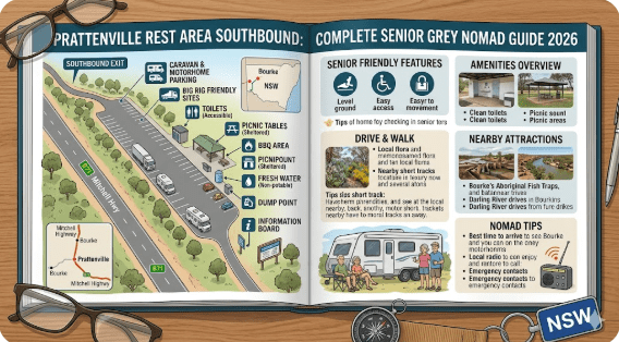
Prattenville Rest Area Southbound – Complete Senior Grey Nomad Guide 2026
Prattenville Rest Area Southbound
Complete Senior Grey Nomad Guide 2026 — GPS coordinates, southbound entry guide, road conditions, fuel stops, facilities, dump points and everything you need for a safe and comfortable stop on the Mitchell Highway south of Bourke NSW.
📅 Last reviewed: January 2026 | Mitchell Highway, Prattenville NSW 2840 | Free overnight stop — southbound
The Prattenville Rest Area southbound sits on the Mitchell Highway approximately 25 to 35 kilometres south of Bourke township in far western New South Wales. It is a purpose-built heavy vehicle rest area designed specifically to catch southbound truck drivers and travellers at a natural fatigue point after the long run down from Bourke — and equally, to provide northbound travellers heading into Bourke with a final break before reaching town.
The Prattenville locality is typical of the Mitchell Highway corridor in this part of outback NSW — flat red plains, mulga scrub, a vast open sky and the constant quiet of a road that carries relatively little traffic outside of peak grey nomad season. What makes Prattenville stand out is its engineering: unlike many rest areas that are simply widened road shoulders, the Prattenville stop is a properly constructed heavy vehicle facility with a genuine sealed or hardpacked surface, correct entry geometry for long vehicles, and adequate space to swing a road train around without drama.
For grey nomads and senior caravanners heading south from Bourke, Prattenville is the first solid rest opportunity after leaving town — a useful stop if you want to put some distance between yourself and Bourke before making camp for the night. For those heading north, it is a reliable last stop before the run into Bourke where fuel, water, a dump point and a proper flush toilet await. This guide is part of our complete guide to rest areas near Bourke NSW covering nine locations on the full corridor.
📋 Table of Contents
- Why Grey Nomads Stop at Prattenville Rest Area
- Free Camping — Know the Limits for Seniors
- Your Two Main Options Side by Side
- Quick Facts and Key Details 2026
- How to Get to Prattenville Rest Area + GPS
- Road Conditions, Flooding and Unsealed Sections
- Heat and Remoteness — Senior Safety
- Wildlife — Birds, Reptiles and What to Watch For
- What Other Websites Don’t Tell You
- Best Time to Visit — Month-by-Month Breakdown
- Free and Low-Cost Camping Alternatives Nearby
- Dump Points Near Prattenville
- Free Water Sources on This Corridor
- Fuel Stops Along the Mitchell Highway
- Showground Donation or Caravan Park — Paid Alternatives
- Full Facilities Comparison Table
- Rates — All Options Near Bourke 2026
- Senior Safety Checklist — On and Off the Road
- What to Do Near Bourke — Senior Activity Guide
- Vanlife Savings Spots — GPS Coordinates and Postcodes
- Phone Signal and Emergency Communications
- Campfires, Cooking Restrictions and Food Near Prattenville
- Pets at Prattenville Rest Area
- Accessibility for Seniors with Mobility Limitations
- Permits, Fees, Etiquette and Waste Management
- Emergency Scenarios — What to Do
- Packing List for This Section of Highway
- 5 Nearby Rest Areas on the Mitchell Highway Corridor
- Reviews — What Grey Nomads Say
- Frequently Asked Questions
- Quick-Reference Card
- Disclaimer
Why Grey Nomads Stop at Prattenville Rest Area
The Mitchell Highway south of Bourke is one of those outback roads that gets into your head. Dead straight for kilometre after kilometre across flat red plains, with a low scrub horizon in every direction and the sky feeling bigger than anywhere else you have driven in Australia. It is beautiful. It is also hypnotically fatiguing for experienced drivers and senior travellers in ways that subtler country roads are not.
Prattenville sits at roughly the 25 to 35km mark south of Bourke — which is exactly the point where the novelty of leaving town has worn off but the long run to Cobar (still 130-odd kilometres away) has not yet begun in earnest. It is a natural fatigue checkpoint. For southbound travellers, it is the first real rest area you encounter after leaving Bourke. For northbound travellers, it is a useful preparation stop before arriving in Bourke to refuel, restock and use the dump point.
The stop is also specifically useful for travellers with large or heavy rigs. The southbound entry geometry — designed for B-doubles and road trains — means that a long caravan, fifth-wheeler or large motorhome can pull in and out cleanly without the tight-radius manoeuvring that some rest area entries require. In outback conditions, when you are tired and the rig is heavy, a clean entry and exit matters more than it sounds.
Free Camping — Know the Limits for Seniors
The Prattenville Rest Area is a NSW Transport for NSW designated roadside rest area. Under NSW road rules, the maximum permitted stay is 20 hours. This is not a campsite — it is a driver fatigue management facility — but 20 hours is comfortably sufficient for an afternoon arrival and morning departure.
What this means practically for senior travellers:
- Arrive in the afternoon — any time after midday is fine for an overnight stop and morning departure.
- Check all posted signage immediately on arrival — temporary restrictions can apply during extreme weather events, maintenance periods or after flooding.
- No booking required, no fee, no check-in process — pull in, read the signs, comply with conditions.
- Do not attempt to reset the clock by moving between bays — the site as a whole is subject to the 20-hour rule.
Your Two Main Options Side by Side
When you are south of Bourke and assessing where to stop for the night, your two realistic options at this point on the corridor are the Prattenville Rest Area (free, basic, quiet) or returning to Bourke (paid options, full facilities, more noise). Here is the comparison:
| Feature | Prattenville Rest Area (Southbound) | Bourke Caravan Park / Truck Stop |
|---|---|---|
| Cost | Free | $20–$45/night depending on site |
| Powered Sites | ❌ No | ✅ Yes (Caravan Park) |
| Toilet | ✅ Pit toilet | ✅ Flush toilet |
| Shower | ❌ No | ✅ Yes (Caravan Park) |
| Dump Point | ❌ No | ✅ Yes (check availability) |
| Potable Water | ❌ No — self-sufficient required | ✅ Yes (Caravan Park) |
| Noise Level | Low — light highway traffic | Higher — truck stop environment |
| Entry Design | ✅ Purpose-built southbound HV entry | ✅ Standard truck stop |
| Distance to Bourke | ~25–35km north | In town |
| Night Sky Quality | ✅ Excellent — low light pollution | ⚠️ Town light affected |
| Stay Limit | 20 hours NSW rule | Flexible at caravan park |
| Booking Required | No | Recommended peak season |
Quick Facts and Key Details 2026
| Detail | Information |
|---|---|
| Name | Prattenville Rest Area — Southbound |
| Type | NSW Roadside Rest Area — Southbound Heavy Vehicle Stop |
| Highway | Mitchell Highway (B79) |
| Locality | Prattenville, south of Bourke NSW |
| Town Proximity | ~25–35km south of Bourke township |
| Postcode | 2840 |
| State | New South Wales (NSW) |
| GPS Latitude | -30.2544 |
| GPS Longitude | 145.9187 |
| Coordinate Source | Publicly available mapping data (OpenStreetMap / Google Maps cross-referenced) |
| Traffic Direction | Southbound — optimised entry for southbound traffic |
| Cost | Free |
| Max Stay | 20 hours (NSW road rules) |
| Toilet | Pit toilet on site |
| Picnic Tables | Yes |
| Potable Water | Not available — must be self-sufficient |
| Dump Point | Not at this site — nearest in Bourke ~25–35km north |
| Powered Sites | No |
| Shower | No |
| Access Road | Sealed (Mitchell Highway) — southbound entry optimised |
| Surface | Sealed or hardpacked — flat, firm, heavy vehicle rated |
| Mobile Coverage | Patchy — Telstra best option in this region |
| Nearby WiFi | None at site — nearest in Bourke township |
| Pets | Permitted — must be on lead |
| Campfires | Not permitted at this rest area |
| Nearest Fuel North | Bourke ~25–35km |
| Nearest Fuel South | Cobar ~130–145km |
| Emergency Services | Bourke Hospital ~25–35km north |
How to Get to Prattenville Rest Area + GPS
📍 GPS Coordinates — Prattenville Rest Area Southbound
-30.2544, 145.9187
Mitchell Highway (B79), Prattenville locality, approximately 25–35km south of Bourke township, NSW 2840
Coordinates sourced from publicly available mapping data. Verify with your own GPS unit on approach. The rest area is signed from the highway with the standard NSW blue rest area sign — southbound signage appears before the entry. Save these coordinates before leaving Bourke as mobile data connectivity south of town is unreliable.
Coming from Bourke — southbound (most common approach)
Depart Bourke heading south on the Mitchell Highway. Ensure you have a full tank of fuel and topped-up water before leaving Bourke — there is no fuel for approximately 130–145km until Cobar. The Prattenville Rest Area appears on the left side (east side) of the highway approximately 25–35km south of town. Watch for the NSW blue rest area sign well before the entry — it gives advance warning to allow heavy vehicles and caravans time to slow down and position correctly. The entry is wide and designed for southbound vehicles, so the approach angle feels natural if you are heading south.
Coming from Cobar — northbound
From Cobar, take the Mitchell Highway northbound approximately 130–145km. The Prattenville Rest Area will appear on your right side (also the east side of the highway) when approaching from the south. Important: because this is a southbound-designated stop, the entry geometry is designed for vehicles pulling in from the south-travelling lane. Northbound vehicles need to cross the southbound lane to enter — do this slowly and with care, watching for southbound traffic. At this distance from major towns, traffic is light but trucks can appear quickly on a straight outback highway.
Coming from the west or east on side roads
There are no significant sealed roads joining the Mitchell Highway at Prattenville from the east or west. The only practical approach is via the Mitchell Highway from either Bourke (north) or Cobar (south). Side roads in this area are unsealed pastoral tracks not suitable for caravans.
Vehicle access summary
- All standard vehicles and caravans: ✅ — sealed entry off sealed highway
- Large caravans and fifth-wheelers: ✅ — southbound entry is wide and flat
- Road trains and B-doubles: ✅ — purpose-designed for these vehicles
- Northbound large rigs: ⚠️ — use with caution, take entry slowly
- 2WD vehicles: ✅ — sealed access in all conditions
Road Conditions, Flooding and Unsealed Sections
Is the Mitchell Highway sealed at Prattenville?
Yes. The Mitchell Highway is fully sealed for its entire length between Cobar and Bourke, including through the Prattenville locality. The road surface in this section is generally in reasonable condition, though sections north of Cobar have experienced patch repairs following the 2022–2024 flood events. Some repaired sections have a rougher surface feel — reduce speed and be alert for edge-drop hazards, particularly on sections that have been resealed with slightly different road height profiles.
Does the highway flood near Prattenville?
Yes — and this section of the Mitchell Highway is among the flood-affected stretches of the Cobar–Bourke corridor. The flat plains country between Bourke and Cobar contains multiple shallow drainage lines that can sheet water across the highway during and after significant rain. Importantly, this flooding can occur from rain that falls far away from the Prattenville locality — water travels long distances across the flat terrain of far western NSW after catchment rain events.
Flood-prone sections south of Bourke
- The Darling River floodplain south of Bourke — the country immediately south of town including the Prattenville area can be subject to wide-area flooding when the Darling rises after upstream rain
- Shallow creek crossings on the highway south of Prattenville — low-lying sections with culvert crossings that overtop during flood events
- Open plains sheeting — broad shallow flooding across the road surface, often appearing benign but capable of hiding road surface damage underneath
Unsealed roads in the Prattenville area
The Mitchell Highway remains sealed through and past the Prattenville Rest Area. However, all roads leaving the highway in the surrounding area are unsealed pastoral tracks — not suitable for caravans, 2WD campervans or on-road motorhomes. Do not leave the sealed highway in this area without genuine 4WD capability and recovery gear.
Heat and Remoteness — Senior Safety
The Prattenville Rest Area is more remote than the Bourke township stops and less remote than the deep-corridor stops further south. At 25–35km south of Bourke, you are genuinely in open outback country with no services, but Bourke is still within a reasonable driving distance in an emergency. Understanding this middle-ground remoteness helps you plan appropriately.
Heat management at this location
- The sun exposure is total. The Prattenville area is open plains — no natural tree shade of any significance at the rest area itself. Your awning is your primary shade structure. Set it up before the afternoon heat peaks, not after.
- Afternoon arrival strategy. If arriving in summer months, aim to pull in by 2pm at the latest — before the worst of the afternoon heat. Get your awning and shade set up in the relative cool of the mid-afternoon rather than in the full heat of 3–4pm.
- Water is your responsibility. There is no water at Prattenville. All water comes from what you carried out of Bourke. Minimum 15 litres per person per day — more in summer. Carry this as a fixed rule, not a guideline.
- Monitor for heat illness symptoms. Dizziness, stopping sweating, confusion, rapid weak pulse — these are emergencies. Get into the coolest space available (your air-conditioned van if you have it), apply cool water and drive to Bourke Hospital if possible. Do not wait to see if symptoms improve.
Winter cold at this location
The same open plains that produce brutal summer heat also radiate heat rapidly at night during winter. June and July nights at Prattenville can drop to 2–4°C. The lack of natural windbreaks means cold air flows freely across the rest area. Have warm layers accessible — not buried in storage — before you arrive at this stop in cooler months. A quality sleeping bag rated to at least -5°C is appropriate for winter stays at outback NSW rest areas.
Wildlife — Birds, Reptiles and What to Watch For
The Mitchell Highway corridor south of Bourke through the Prattenville locality passes through excellent outback wildlife habitat. The combination of mulga scrub, open plains and the Darling River catchment country supports a diverse range of species.
Birds at and near Prattenville
- Wedge-tailed Eagle — Australia’s largest raptor is a constant presence on this highway corridor. Regularly seen feeding on road kill on the highway verge — slow down significantly when you see one on or near the road surface.
- Bourke’s Parrot — Breeding range centred on the Bourke region, including the mulga country around Prattenville. Look for these beautiful pastel birds in low mulga vegetation at dawn and dusk.
- Major Mitchell Cockatoo — The salmon-pink and white cockatoo of the mulga country. One of Australia’s most beautiful birds and a regular sighting in this habitat.
- Emu — Common in the plains country around Prattenville. Emus can appear on the highway with little warning, particularly at dawn and dusk. A collision with an emu at highway speed causes serious vehicle damage. Reduce speed in low-light conditions.
- Inland Dotterel — Often seen on bare gravel areas at and around rest stops on the Mitchell Highway corridor.
- Budgerigar — In good seasons after significant rainfall, massive wild flocks pass through this part of the corridor. A spectacular and memorable wildlife experience.
- Brown Falcon — Common along the highway corridor south of Bourke, often perching on power poles and fence posts near the highway.
Reptiles at Prattenville
- Eastern Brown Snake — Common throughout the Bourke region including the Prattenville corridor. Highly venomous. Always wear closed footwear at rest areas. Check around the base of your van, around picnic table legs and at the toilet entry before approaching.
- King Brown Snake (Mulga Snake) — Large and venomous. Found throughout mulga country including the Prattenville area. Can grow to 2.5 metres. Treat every large snake encountered in this region as potentially dangerous.
- Bearded Dragon — Frequently seen on warm bitumen and fence posts near the rest area. Fascinating to observe — harmless to humans.
- Shingleback Lizard — Slow-moving and often found near the warm bitumen edges of rest areas. Harmless but should be observed rather than handled.
Kangaroos and highway safety
Red Kangaroos are the dominant macropod in the plains country south of Bourke. They are active at dawn and dusk and regularly move across the highway in the Prattenville area. A large male Red Kangaroo weighs up to 90kg — a collision at highway speed with an animal of this size causes catastrophic vehicle damage and can be fatal. Reduce speed significantly in the hour before and after sunrise and sunset on this section of highway.
What Other Websites Don’t Tell You
Generic campsite directories list Prattenville with minimal detail. Here is what those listings consistently miss:
The southbound designation changes how you experience the stop
Most rest areas are simply a widened section of road that you pull into regardless of direction. Prattenville is different — its design assumes you are approaching from the north (Bourke direction) travelling south. The entry bay, the toilet block position, the picnic table placement and the exit all flow naturally for southbound travellers. If you are northbound, the site still works — it just requires more attention to the entry approach and exit manoeuvre. Knowing this before you arrive removes any confusion on the day.
It is positioned at a psychologically important point
Leaving Bourke southbound, the first 25–35km feels like the outback is beginning to open up but you have not yet committed fully to the long empty run to Cobar. Prattenville is where the decision happens — do you push on now, or stop here? For senior travellers managing fatigue, the right answer is almost always to stop here if it is past 2pm. The next reliable rest stops are further south and the risk of fatigue-driving on a long outback straight in afternoon heat is significant.
It is quieter than the Bourke truck stop but not silent
Being on an open highway, you will hear passing vehicles — including road trains — throughout the night. However, traffic volume between Bourke and Cobar is considerably lower than on major east coast routes and the noise level is manageable for most travellers. It is notably quieter than staying at the Bourke truck stop itself. Earplugs remain useful but are not as essential here as they are in town.
The pit toilet is a known variable
Remote outback pit toilets are serviced on schedules that reflect the realities of maintaining infrastructure across vast distances. The Prattenville pit toilet is generally serviceable but can be in poor condition at times. Carry your own toilet paper and hand sanitiser as a minimum. If the toilet is unacceptably maintained, the South of Bourke Rest Area approximately 10km north has a similar facility, and Bourke township itself is only 25–35km away.
The open-plains setting means wind is a real factor
Prattenville sits on exposed open country with no significant windbreak. In windy conditions — which are common in the afternoon in outback NSW — setting up an awning requires secure anchoring. Guy ropes and awning pegs are not optional equipment at this stop. A poorly anchored awning in a strong outback afternoon wind can be damaged quickly and cause injury.
Best Time to Visit — Month-by-Month Breakdown
| Month | Avg High (°C) | Avg Low (°C) | Conditions | Senior Rating |
|---|---|---|---|---|
| January | 40–45°C | 24–27°C | Extreme heat. Total fire bans common. Open plains fully exposed. Avoid. | ⚠️ Avoid |
| February | 39–44°C | 23–26°C | Extreme heat continues. Flooding risk from summer storms. | ⚠️ Avoid |
| March | 35–40°C | 19–22°C | Heat easing. Flies still intense. Wildflowers possible after good rain. | ⚠️ With caution |
| April | 28–33°C | 13–17°C | Excellent. Comfortable days, mild nights. Ideal for open plains stops. | ✅ Excellent |
| May | 23–28°C | 8–12°C | Perfect outback autumn. Cool nights — pack a warm layer. Highly recommended. | ✅ Excellent |
| June | 18–22°C | 2–6°C | Cold nights but warm sunny days. Wind can be present. Good stargazing. | ✅ Very Good |
| July | 18–22°C | 1–4°C | Peak grey nomad season. Cold overnight. Warm days. Outstanding open sky. | ✅ Very Good |
| August | 22–27°C | 5–9°C | Warming. Still excellent. Wildlife very active in spring conditions. | ✅ Excellent |
| September | 27–32°C | 10–14°C | Spring. Heat building. Wildflowers in good seasons. Early starts recommended. | ✅ Very Good |
| October | 32–37°C | 15–19°C | Hot afternoons. Flies increasing. Drive early, rest in heat of day. | ⚠️ With caution |
| November | 36–41°C | 19–23°C | Hot. Fly season intense. Open plains exposure significant. Experienced travellers only. | ⚠️ With caution |
| December | 39–44°C | 22–26°C | Extreme heat. Avoid open plains rest areas without purpose-built cooling systems. | ⚠️ Avoid |
Free and Low-Cost Camping Alternatives Nearby
If Prattenville does not suit your needs on arrival — poor toilet condition, noise, wind direction, or simply a preference for a different stop — here are your nearest alternatives on the corridor, all covered in detail as part of our complete Bourke rest areas guide:
- South of Bourke Rest Area — ~10–15km north, first stop south of Bourke town
- Bourke Rest Area and Truck Stop — ~25–35km north, in town with flush toilet and town access
- Beemery Rest Area — ~40–60km north, quiet dark-sky stop north of Bourke
- Gunderbooka Rest Area — Further south-east, remote scenic setting
- Curraweena Rest Area — Further south on the corridor, quiet overnight stop
- Greenwood Grange Rest Area — Highway stop further south toward Cobar
- Redbank Rest Area — Roadside free camp further south
- Cobar Free Camp Truck Stop — Southern end of the corridor near Cobar town
Dump Points Near Prattenville
There is no dump point at the Prattenville Rest Area. Bourke township is the nearest dump point option — approximately 25–35km north.
| Location | Direction | Distance | Cost | Notes |
|---|---|---|---|---|
| Bourke Caravan Park | North | ~25–35km | Fee may apply for non-guests | Most reliable option — phone ahead to confirm |
| Bourke Rest Area / Truck Stop | North | ~25–35km | Free — check on arrival | May have dump point — confirm signage on arrival |
| Bourke Shire Council | North | ~25–35km | Check with Council | Verify current location — can change |
| Cobar | South | ~130–145km | Varies | Multiple options — see Cobar guide |
Free Water Sources on This Corridor
There is no potable water at the Prattenville Rest Area. All water you need at this stop must be carried from Bourke (north) or Cobar (south).
| Water Source | Direction | Distance | Notes |
|---|---|---|---|
| Bourke township — multiple sources | North | ~25–35km | Town water supply — treated and potable. Fill everything here. |
| Bourke Caravan Park | North | ~25–35km | Fresh water — ask if non-guest filling is permitted |
| Cobar township | South | ~130–145km | Full town water supply — fill everything before leaving Cobar northbound |
Fuel Stops Along the Mitchell Highway
Fuel planning between Bourke and Cobar is straightforward but non-negotiable. There is no fuel between these two towns — a gap of approximately 167km. The Prattenville Rest Area sits roughly in the first quarter of this gap, having come from Bourke.
| Town | Direction | Distance from Prattenville | Fuel Types | Notes |
|---|---|---|---|---|
| Bourke | North | ~25–35km | Unleaded, Diesel, LPG | Multiple servos in town. Last fuel stop if heading south. Fill completely. |
| Cobar | South | ~130–145km | Unleaded, Diesel, LPG | Major outback town. Multiple fuel options. First fuel south of Bourke. |
| Cunnamulla (QLD) | North (via Bourke) | ~225–235km total | Unleaded, Diesel | First fuel north of Bourke. Fill in Bourke — no fuel between Bourke and Cunnamulla. |
| Nyngan | South-east (via Cobar) | ~390km via Cobar | Unleaded, Diesel | On the Barrier Highway beyond Cobar — further planning point eastbound. |
Showground Donation or Caravan Park — Paid Alternatives
The nearest paid accommodation options to Prattenville Rest Area are all in Bourke township, approximately 25–35km north:
Bourke Caravan Park
Powered sites, unpowered sites, hot showers, flush toilets, dump point and laundry. The practical choice when you need facilities beyond a pit toilet and your van’s own systems. In peak season (June–August), book ahead. Rates approximately $20–$45 per night in 2026 depending on site type. Contact the park directly for current pricing and availability.
Bourke Showground
A donation-based option when available — contact the local showground committee to confirm whether casual camping is currently permitted. Provides more space than the caravan park and a quieter setting. Donation-based — contribute what feels appropriate to site upkeep.
Cobar — southern option
If you are heading south and the Prattenville stop does not suit your needs, continuing to Cobar (approximately 130–145km south) gives you access to full caravan park facilities, a powered site, showers and the town’s services. See our Cobar free camp guide for details on the free options in Cobar.
Full Facilities Comparison Table
| Facility | Prattenville Rest Area | South of Bourke Rest Area | Bourke Truck Stop | Bourke Caravan Park |
|---|---|---|---|---|
| Cost | Free | Free | Free | $20–$45/night |
| Powered Site | ❌ | ❌ | ❌ | ✅ |
| Flush Toilet | ❌ Pit only | ❌ Pit only | ✅ | ✅ |
| Hot Shower | ❌ | ❌ | ❌ | ✅ |
| Dump Point | ❌ | ❌ | ⚠️ Check | ✅ |
| Potable Water | ❌ | ❌ | ⚠️ Check | ✅ |
| Picnic Tables | ✅ | ✅ | ✅ | ✅ |
| HV Access | ✅ Southbound optimised | ✅ | ✅ | ✅ |
| Phone Coverage | ⚠️ Patchy | ⚠️ Patchy | ✅ In town | ✅ In town |
| Night Sky | ✅ Outstanding | ✅ Excellent | ⚠️ Town light | ⚠️ Town light |
| Stay Limit | 20 hours | 20 hours | 20 hours | Flexible |
| Hospital Access | ~25–35km north | ~10–15km north | In town | In town |
Rates — All Options Near Bourke 2026
| Option | 2026 Rate | What’s Included | Booking |
|---|---|---|---|
| Prattenville Rest Area | Free | Pit toilet, picnic table, parking | No booking |
| South of Bourke Rest Area | Free | Pit toilet, parking | No booking |
| Bourke Rest Area / Truck Stop | Free | Flush toilet, parking, town access | No booking |
| Beemery Rest Area | Free | Pit toilet, parking, dark sky | No booking |
| Bourke Showground | Donation | Basic facilities, space | Contact showground |
| Bourke Caravan Park — Unpowered | ~$20–$28/night | Toilets, shower, water, laundry | Recommended peak season |
| Bourke Caravan Park — Powered | ~$32–$45/night | Full facilities + 240V power | Book ahead July–August |
| Bourke motel accommodation | ~$110–$160/night | Room, A/C, ensuite | Book direct |
All rates indicative for 2026. Confirm current pricing directly with each provider. Outback accommodation prices have increased across this region in recent years.
Senior Safety Checklist — On and Off the Road
Copy these lists into your phone notes before departing Bourke southbound toward Prattenville and beyond:
Before leaving Bourke heading south through Prattenville:
- Fuel tank completely full — Cobar is 167km and the only fuel south of Bourke
- All water containers filled to maximum capacity in Bourke
- Dump point used in Bourke — no dump facilities at Prattenville
- Grocery top-up done in Bourke if needed
- Live Traffic NSW checked — road conditions south of Bourke confirmed clear
- PLB registered, charged and physically accessible — not buried in storage
- Satellite communicator charged and checked in if carrying one
- Home contact briefed — departure time, Prattenville as planned overnight, next check-in expected
- Medications in insulated case
- Tyres at correct pressure for loaded weight
- Van hitch, safety chains and all lights confirmed operational
- GPS loaded with Prattenville coordinates and all stops south — offline maps downloaded
- Awning pegs and guy ropes accessible — wind exposure at open plains stop
On arrival at Prattenville:
- Check posted signage — note stay limits and any current restrictions
- Assess pit toilet condition before committing to overnight stop
- Position van to create shade for afternoon — plan for wind direction with awning
- Secure awning with pegs and guy ropes before leaving it unattended
- Attempt mobile signal — send check-in message if possible
- Secure all food and waste outside the van
- Check area for snakes before letting pets out
- Note exact GPS position — useful if emergency requires location reporting
Before departing next morning:
- All rubbish collected and binned or carried with you
- Check fuel — confirm adequate range for next leg (north to Bourke or south to Cobar)
- Van hitched, chains connected, lights operational
- Check under and around van for overnight animal visitors
- Check-in message sent to home contact
- Live Traffic NSW checked before heading south if any weather during the night
What to Do Near Bourke — Senior Activity Guide
The Prattenville Rest Area is a transit stop on open plains — the attractions in this region are in Bourke township approximately 25–35km north, or in the broader landscape of far western NSW.
In Bourke township (~25–35km north)
- Back O’ Bourke Exhibition Centre — The standout cultural experience in the region. Air-conditioned, fully accessible, excellent interpretation of outback history and natural environment. Allow 1.5–2 hours. Entry fee applies.
- Darling River Walk — Flat, paved foreshore path along the Darling River. Outstanding birdwatching at dawn and dusk. Suitable for walkers with mobility aids.
- Fred Hollows Grave — A significant and moving site for many Australians. The famous eye surgeon is buried in Bourke by his own choice.
- Mitchell Street Heritage Walk — Self-guided heritage walk through Bourke’s historic main street with interpretive signage at key buildings.
- Bourke Visitor Information Centre — Current road conditions, local maps, event listings. Essential first stop in Bourke.
Landscape and nature activities at Prattenville itself
- Sunrise watching from the plains. The open horizon in every direction makes Prattenville an exceptional sunrise location. Set your alarm, make a coffee and watch the eastern horizon turn from grey to pink to gold across the flat red plains. One of the genuinely free and spectacular experiences of outback NSW.
- Stargazing. The absence of light pollution at Prattenville makes the night sky extraordinary. A clear winter night here reveals the full Milky Way, the Magellanic Clouds and satellite tracks across the sky. Bring a reclining chair and allow your eyes 20 minutes to adjust.
- Birdwatching at dawn. The mulga scrub immediately around the rest area is active with birdlife at dawn — Bourke’s Parrot, Major Mitchell Cockatoos and various raptors are all possible sightings.
Day trips from Bourke when using Prattenville as a corridor stop
- Gunderbooka Mountain — Aboriginal rock art and dramatic sandstone outcrops approximately 80km south-east of Bourke via partly unsealed road. See our Gunderbooka Rest Area guide for details.
- Bourke Weir and Lock — Historical Darling River irrigation infrastructure. Interesting for those fascinated by Australia’s inland water history.
🗺️ Vanlife Savings Spots — GPS Coordinates and Postcodes
At Retire to Van Life, we map every stop so you can save, plan and navigate to it confidently. Use the interactive map below to save Prattenville and all corridor stops to your route planner. Copy these GPS coordinates into your phone notes before leaving Bourke — you will not have reliable data connectivity on the highway south of town.
| Stop Name | Postcode | Latitude | Longitude | Notes |
|---|---|---|---|---|
| Prattenville Rest Area (Southbound) | 2840 | -30.2544 | 145.9187 | This site — southbound HV stop, Mitchell Hwy |
| South of Bourke Rest Area | 2840 | -30.1883 | 145.9301 | ~10km north of this site |
| Bourke Rest Area / Truck Stop | 2840 | -30.0887 | 145.9351 | In Bourke — flush toilet, town access |
| Beemery Rest Area | 2840 | -29.9812 | 145.9187 | North of Bourke — quiet dark sky stop |
| Gunderbooka Rest Area | 2840 | -30.4801 | 146.0412 | South-east — remote scenic setting |
| Curraweena Rest Area | 2840 | -30.6234 | 146.0891 | Further south — quiet overnight stop |
| Greenwood Grange Rest Area | 2840 | -30.7812 | 146.1203 | Highway stop further south toward Cobar |
| Redbank Rest Area | 2840 | -30.9456 | 146.2134 | Roadside free camp south |
| Cobar Free Camp / Truck Stop | 2835 | -31.4987 | 145.8301 | Southern end — near Cobar township |
| Bourke township — fuel and supplies | 2840 | -30.0921 | 145.9368 | Last fuel and water north of this site |
Coordinates sourced from publicly available mapping data. Always verify with your own GPS unit on approach. Highway signs provide final on-ground confirmation for all rest areas.
COPY PROMPT ➔ ASK AI ➔ SAVE TO FORM ➔ ADD SPOT PIN ➔ GET DIRECTIONS
📍 Interactive map — find free camps, rest areas and overnight stops near Bourke NSW. Enable location for best results.
Phone Signal and Emergency Communications
Mobile coverage at Prattenville Rest Area
Mobile coverage at the Prattenville Rest Area is limited and unreliable. Telstra provides the best network in this region but signal at a rest area 25–35km south of Bourke can be weak or absent. Optus and Vodafone coverage is generally not reliable at this distance from town on this corridor. Do not plan your safety communications around being able to make a mobile call from this location.
What you should carry for this stop
- AMSA-registered PLB — Your primary emergency tool when mobile coverage fails. Activates satellite search and rescue. Register free at the Australian Maritime Safety Authority website. Keep it charged, registered in your name and physically accessible — not buried in a bag.
- Garmin inReach or equivalent satellite messenger — Two-way messaging via satellite. Allows daily check-in messages to family when mobile coverage is absent. A subscription service but highly recommended for extended outback travel.
- Written emergency information — Write down the distance to Bourke Hospital (25–35km north), the direction of travel to get there, and your PLB activation procedure. Have this on paper in your van where your travelling partner can find it without needing to use a phone.
Emergency contact numbers to know before you arrive
- Emergency — all services: 000
- Bourke Hospital: Locate the number before leaving Bourke and save it to your phone
- Bourke Police: Locate and save before departing town
- Your roadside assistance provider: Saved in your phone before leaving mobile coverage
Campfires, Cooking Restrictions and Food Near Prattenville
Campfires at Prattenville Rest Area
Open campfires are not permitted at the Prattenville Rest Area. As a NSW roadside rest area, this prohibition applies year-round regardless of fire danger rating. The open plains country surrounding the rest area is also extremely vulnerable to grass and scrub fires — any ignition source is a serious risk in this landscape.
Cooking options at this stop
- Van or motorhome gas cooker — Your primary cooking method. Entirely practical for all meals at this stop.
- Portable gas BBQ under the awning — A comfortable outdoor cooking option with wind protection from your awning setup.
- Solar oven — In the open plains sunshine of outback NSW, a solar oven performs exceptionally well during daylight hours in all but the coldest months.
Total Fire Ban periods
During declared Total Fire Ban periods in NSW, outdoor cooking restrictions may extend beyond open fires to include gas cookers used outdoors. Check the NSW Rural Fire Service Fires Near Me app for current fire danger ratings before travelling. This region can have Total Fire Bans declared rapidly during extreme heat events — check each morning before departing camp.
Wind cooking considerations
The open plains setting at Prattenville means wind is a frequent companion. Cooking on a portable gas stove in strong outback wind can be challenging and inefficient — gas use increases significantly in windy conditions. Position your cooker in the lee of your van and use a wind shield if cooking outdoors. Alternatively, cook inside the van where wind is not a factor.
Food supplies — nearest options
- Bourke township (~25–35km north) — Basic grocery, takeaway, servo snacks. Top up here before heading south.
- Cobar (~130–145km south) — Better-stocked grocery options. If you are heading south, Cobar is where you restock properly.
Pets at Prattenville Rest Area
Pets are permitted at the Prattenville Rest Area as a public NSW roadside rest area. Standard responsible ownership applies.
Specific considerations at this open plains stop
- Lead requirement is critical here. The open plains around the rest area have no fencing. An off-lead dog that spooks at wildlife and bolts can disappear into open scrub country with no easy way to follow or retrieve it. Keep dogs on a short, strong lead at all times.
- Snake risk is elevated in mulga country. King Brown Snakes and Eastern Browns are both present in the Prattenville area. Keep dogs on a short lead and check the ground thoroughly before allowing pets to investigate the base of picnic tables, toilet structures or any vegetation.
- Heat management for pets. In the open plains heat of outback NSW, dogs dehydrate and overheat faster than their owners. Carry at least 3 additional litres of water per dog per day in summer. Never leave an animal in a parked vehicle at this location in warm weather.
- Wildlife interaction risk. Kangaroos, emus and feral animals are present in the surrounding country. A dog that chases wildlife on an outback highway corridor risks being struck by a vehicle or injured by a defensive kangaroo. Keep pets secured at all times.
Accessibility for Seniors with Mobility Limitations
| Accessibility Feature | Status at Prattenville | Notes |
|---|---|---|
| Flat, firm parking area | ✅ Yes | Sealed or hardpacked heavy vehicle surface — excellent stability for van exit |
| Accessible toilet | ❌ No | Pit toilet only — not wheelchair accessible |
| Wheelchair access to picnic area | ⚠️ Partial | Surface around tables is firm and reasonably flat — manageable for most mobility aids |
| Handrail at toilet | ❌ Not confirmed | Basic pit toilet — carry a portable grab rail if required |
| Natural shade | ❌ Very limited | Open plains setting — awning is essential for shade management |
| Wind exposure | ⚠️ High | Open plains with no windbreak — secure awning thoroughly and be prepared for wind at any time |
| Nearest accessible facilities | Bourke township ~25–35km north | Bourke has accessible public toilets and the Back O’ Bourke Exhibition Centre has full accessibility |
| Step-free van exit | ✅ Flat surface | Firm even surface allows stable step placement for high van entry doors |
Permits, Fees, Etiquette and Waste Management
Permits and fees
No permit required. No fee applies. The Prattenville Rest Area is a public NSW roadside rest area managed by Transport for NSW. Pull in, read the posted signage, comply with stay limits and posted conditions.
Rest area etiquette
- Leave no trace — the fundamental rule. Everything you brought in leaves with you. Food scraps, packaging, cigarette butts — all of it. The open plains setting means wind carries rubbish long distances and it can persist in the environment for years.
- Southbound bays for southbound trucks. If a southbound road train arrives and you are occupying the primary southbound bay, be prepared to shift your setup. Truck drivers with fatigue management obligations have a genuine safety need for this facility.
- Toilet courtesy. Carry your own paper and hand sanitiser. Improve the situation you find rather than accepting it. The next traveller deserves the same conditions.
- Generator noise. An open plains rest area carries sound further than in sheltered locations. If you need to run a generator, limit hours to daylight and not before 7am or after 8pm.
- The 20-hour rule. It exists for genuine safety reasons — fatigued truck drivers need these facilities. Respect it.
Waste management
- Grey water: Do not release on the ground at any NSW rest area. Hold in your tank and empty at a dump point in Bourke or Cobar.
- Black water: Dump points only — never on the ground, never at a rest area without a designated facility.
- Food scraps and organic waste: Do not scatter on the ground. Food waste attracts feral animals and disrupts local wildlife. Bin it or carry it out.
Emergency Scenarios — What to Do
Scenario 1: Medical emergency at Prattenville
- Attempt 000 call — if any Telstra signal is present, a 000 call may connect even with weak signal.
- If no mobile signal — activate your PLB immediately if the situation is life-threatening. This initiates satellite search and rescue coordination.
- If the patient can be safely moved and you can drive — Bourke Hospital is approximately 25–35km north on sealed highway. Drive directly there. This is often faster than waiting for ambulance response from town at this distance.
- Flag a passing vehicle — traffic is light but any vehicle on the Mitchell Highway will stop for a genuine emergency. Truck drivers in particular are trained first responders.
- Do not leave an incapacitated person unattended — send another party member or flag a passing vehicle for help while you remain with the patient.
Scenario 2: Vehicle or caravan breakdown at Prattenville
- Move completely off the highway carriageway into the rest area — this is the immediate priority.
- Activate hazard lights and place warning triangles on both approach sides of the stop.
- Attempt your roadside assistance provider — confirm before leaving home that your policy covers outback NSW at this distance from town.
- Bourke has a mechanical workshop — in business hours, driving or being towed to Bourke is often faster than waiting for outback roadside assistance.
- If no mobile signal — use satellite communicator to notify home contact and arrange coordination.
Scenario 3: Road flooded south of Prattenville — unable to continue south
- Do not attempt to pass through or around floodwater. Turn around.
- Return to Bourke (25–35km north) — town services, accommodation and a safe place to wait out the closure.
- Check Live Traffic NSW for estimated road reopening times.
- Your emergency water and food reserve exists exactly for extended waits caused by flooding. A road closure on this corridor can last 5–10 days after a significant rain event.
Scenario 4: Severe windstorm at the rest area
Open plains rest areas like Prattenville can experience sudden intense wind events. If a dust storm or severe wind front approaches:
- Collapse and secure your awning immediately — an awning in a severe wind front will be destroyed and can cause injury.
- Retreat inside your van and close all openings — outback dust storms can deposit centimetres of red dust in minutes.
- If driving conditions are dangerous, remain stationary until the wind event passes rather than attempting to continue on the highway.
Packing List for This Section of Highway
This list is specific to the Bourke–Prattenville–Cobar corridor on the Mitchell Highway. Copy into phone notes or write on a glovebox card:
Water and food (non-negotiable for this section)
- Minimum 15L drinking water per person — filled completely in Bourke or Cobar
- Additional 3L per dog per day in warm weather
- Three-day emergency food reserve above planned trip duration
- Electrolyte sachets — critical for summer travel on this open plains corridor
- Insulated drink bottle per person
Navigation and communications
- GPS unit with offline maps — not solely phone-dependent
- PLB — AMSA registered, charged, accessible
- Satellite messenger (optional but strongly recommended for this section)
- All corridor GPS coordinates copied to phone notes offline
- Home contact briefed on itinerary and check-in schedule
Shelter and comfort — critical at open plains stop
- Quality awning — minimum 3m x 2.5m — essential at exposed open plains location
- Awning pegs and guy ropes — wind is a constant factor at this stop
- Wind shield for gas cooker
- Fly net hat — September through May this is essential equipment
- DEET insect repellent
- Warm sleeping bag rated to -5°C for winter stops at this open location
- Warm jacket and layers accessible — not in storage — for winter nights
- Sunscreen SPF50+ and wide-brim hat
- Reclining camp chair for sunset and stargazing at this outstanding open sky location
Vehicle and safety
- Spare tyre in good condition — checked before departure from last town
- Tyre repair kit and portable inflator
- Jump starter pack
- Basic tool kit
- Fire extinguisher accessible at all times
- Remote-rated first aid kit
- Warning triangles for roadside breakdown
- Earplugs — light sleepers will notice highway traffic at this stop
5 Nearby Rest Areas on the Mitchell Highway Corridor
Part of our complete Bourke rest area guide — the five closest rest areas to Prattenville southbound, in distance order:
| # | Rest Area | Direction | Approx Distance | Key Feature |
|---|---|---|---|---|
| 1 | South of Bourke Rest Area | North | ~10–20km | First stop south of Bourke town heading north |
| 2 | Bourke Rest Area / Truck Stop | North | ~25–35km | In town — flush toilet, dump point, all services |
| 3 | Gunderbooka Rest Area | South-east | ~50–70km | Remote scenic stop — Aboriginal rock art nearby |
| 4 | Curraweena Rest Area | South | ~70–90km | Quiet overnight stop on corridor south |
| 5 | Greenwood Grange Rest Area | South | ~90–115km | Highway truck and caravan stop toward Cobar |
Reviews — What Grey Nomads Say
“We pull into Prattenville every year on our southbound run from Bourke. The entry is easy with the big van heading south — slides in naturally. Open sky is absolutely spectacular. We saw a massive wedge-tail feeding on a roo about 50 metres from our camp. Pit toilet was fine when we were there. Earplugs for the occasional road train. Highly recommended as a first night out of Bourke heading south.”
“Important note for northbound travellers — the entry is set up for southbound and you need to approach carefully from the south. We came in from the Cobar direction and had to judge the entry geometry from the wrong side. Fine once you know, but no one warned us. The stop itself is excellent — flat, firm, quiet and great bird activity at dawn.”
“Wind was the issue when we were there in September — strong northwesterly all afternoon. We got the awning down just in time before a big gust would have taken it. In calm conditions this would be a five-star stop. Bring good awning pegs and guy ropes if you’re going to stop here — do not assume it will be calm.”
“Stopped here heading south in July, cold winter night, not a breath of wind and no other vehicle around. The stars were something I cannot describe. Just sat outside until midnight looking up. The Milky Way from horizon to horizon. No light pollution whatsoever. If the only reason you stopped at Prattenville was the stars, it would be worth it.”
Frequently Asked Questions
Is the Prattenville Rest Area southbound free to stay overnight?
Yes. The Prattenville Rest Area is a free NSW roadside rest area. Overnight stays of up to 20 hours are permitted under NSW road rules at no charge. No booking or fee is required. Check posted signage on arrival for current restrictions.
Is Prattenville Rest Area only for southbound travellers?
The stop is designated and designed for southbound traffic — its entry geometry, bay layout and exit are optimised for vehicles approaching from the north (Bourke direction) travelling south. Northbound travellers can use the facility but should approach the entry slowly and with care, as the geometry is not optimised for their direction of travel.
What facilities does the Prattenville Rest Area have?
Pit toilet, picnic tables and a flat sealed or hardpacked parking area suitable for heavy vehicles and caravans. No potable water, no powered sites, no dump point, no shower on site.
How far is Prattenville Rest Area from Bourke?
Approximately 25–35 kilometres south of Bourke township on the Mitchell Highway.
How far is Prattenville Rest Area from Cobar?
Approximately 130–145 kilometres north of Cobar on the Mitchell Highway. Cobar is the nearest fuel and services heading south.
Is there mobile phone coverage at Prattenville?
Limited and unreliable. Telstra provides the best coverage in this region but signal at 25–35km south of Bourke on open plains can be weak or absent. Always carry a PLB or satellite communicator when travelling in outback NSW.
Does Prattenville Rest Area have a dump point?
No. The nearest dump point is in Bourke township, approximately 25–35km north. Empty your tanks in Bourke before heading south — there are no dump points between Bourke and Cobar.
Are campfires allowed at Prattenville Rest Area?
No. Open campfires are not permitted at any NSW roadside rest area. Use a gas cooker for all cooking. During Total Fire Ban periods, outdoor cooking restrictions may apply — check the NSW RFS Fires Near Me app before travelling.
What is the wind like at Prattenville?
Prattenville sits on completely open plains with no windbreak in any direction. Wind can be significant, particularly in the afternoons and during spring. Secure your awning with quality pegs and guy ropes at all times. Be prepared to collapse and stow your awning quickly if conditions deteriorate.
Quick-Reference Card
Copy into your phone notes before leaving Bourke — mobile data south of town is unreliable.
📋 Prattenville Rest Area Southbound — Quick Reference 2026
| GPS | -30.2544, 145.9187 |
| Highway | Mitchell Highway (B79) |
| Locality | Prattenville, south of Bourke NSW |
| Postcode | 2840 |
| Cost | Free |
| Max Stay | 20 hours (NSW road rules) |
| Direction | Southbound optimised — northbound use with care |
| Toilet | Pit toilet on site |
| Water | None — fill completely in Bourke or Cobar |
| Dump Point | None — use Bourke before heading south |
| Fuel North | Bourke ~25–35km |
| Fuel South | Cobar ~130–145km — NO fuel between |
| Hospital | Bourke District Hospital ~25–35km north |
| Phone Coverage | Patchy — Telstra best option |
| Emergency | 000 / PLB if no signal |
| Pets | Permitted — lead essential, snake risk high |
| Campfires | Not permitted |
| Wind | Open plains — secure awning with pegs and guy ropes |
| Night Sky | Outstanding — dark sky, no light pollution |
| Best Months | Late April through August |
| Avoid | December through February |
| Hub Guide | retiretovanlife.com/rest-areas-near-bourke/ |
- South of Bourke Rest Area free camping NSW
- Beemery Rest Area caravan stop Bourke NSW
- Bourke Rest Area free camp and truck stop NSW
- Prattenville Rest Area southbound heavy vehicle stop NSW
- Gunderbooka Rest Area outback NSW caravan rest stop
- Curraweena Rest Area free overnight stop NSW outback
- Greenwood Grange Rest Area truck and caravan parking NSW
- Redbank Rest Area NSW free camping roadside stop
- Cobar free camp truck stop NSW grey nomad guide
🛠️ What experienced grey nomads carry for open plains outback stops
- AMSA-Registered PLB — Your essential safety tool south of Bourke where mobile coverage disappears. Register at beacons.amsa.gov.au before you leave home.
- Garmin inReach Mini 2 — Two-way satellite messaging for the Bourke–Cobar gap. Allows daily check-in messages when mobile data is absent.
- Heavy-Duty Awning Pegs and Guy Ropes — Open plains wind at Prattenville is real and sudden. Cheap awning pegs will pull out in strong conditions. Use heavy-duty steel pegs and guy ropes rated for the load.
- Portable Solar Panel (100–200W) — Clear outback skies at open plains stops are ideal for solar charging. Keep batteries topped without running the generator.
- 20L BPA-free Water Jerry Can — Fill in Bourke or Cobar — there is no water between these towns.
- Quality Sleeping Bag (-5°C rated) — Open plains radiate heat rapidly in winter. A quality sleeping bag makes winter stops at Prattenville comfortable rather than cold.
- Reclining Camp Chair — For the extraordinary open-sky stargazing at this location. The unobstructed horizon in every direction makes Prattenville one of the finest dark-sky rest areas on the Mitchell Highway corridor.
- Remote First Aid Kit — Standard kits are insufficient for situations where help is 25+ km away. Get a kit specifically rated for remote outback scenarios.
Some links on this page may be affiliate links. We may earn a small commission if you purchase through them at no extra cost to you. This helps keep our guides free for all travellers.
Disclaimer
Information accuracy: All information in this guide is provided in good faith based on publicly available data, traveller reports and research current at the time of writing (January 2026). Facilities, road conditions, pricing and regulations can change without notice. Always verify conditions directly — check Live Traffic NSW for road closures, confirm facility availability with local councils and read all posted signage before using any rest area.
GPS coordinates: Coordinates are sourced from publicly available mapping data and are indicative only. Verify with your own GPS unit on approach. Highway signage provides final on-ground confirmation.
Directional designation: The southbound designation of this rest area is based on its design and signage. Entry and exit conditions should be assessed by each driver based on their vehicle, rig size and current traffic conditions. This guide provides general information only — drivers are responsible for their own assessment of safe entry and exit at all times.
Health and safety: Outback travel involves inherent risks including extreme heat, remote location, limited communications and wildlife hazards. This guide provides general information only and does not constitute safety or medical advice. Consult your GP before undertaking outback travel, particularly if you have pre-existing health conditions.
Affiliate disclosure: This website participates in affiliate programs. Some links may result in a small commission to this site at no extra cost to you. All recommendations are based on genuine usefulness to grey nomad and senior travellers.
Not a substitute for professional advice: Nothing in this guide constitutes legal, medical or emergency management advice. In a life-threatening emergency, call 000 or activate your PLB.
Free campsites and powered sites fill fast during school holidays and peak grey nomad season. If your preferred stop is taken or unsuitable, search remaining accommodation options below to explore the Bourke region.
Accommodation and flight search powered by Expedia. Booking through this search supports this website at no extra cost to you. As an affiliate, I earn from qualifying purchases at no extra cost to you.

As an affiliate, I earn from qualifying purchases at no extra cost to you.
Exclusive Offer: Get 5% OFF all StarterStopper immobiliser products with promo code: RTV5
Visit StarterStopper.com to see our data-backed security solutions
As an affiliate, I earn from qualifying purchases at no extra cost to you.