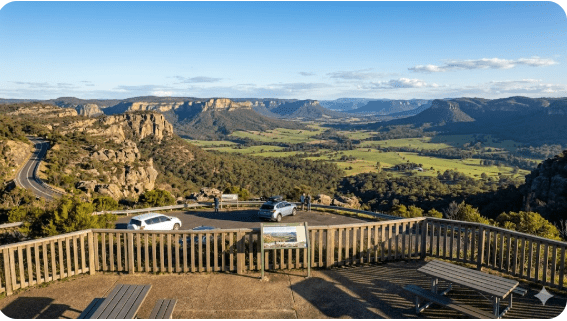
Pearsons Lookout Rest Area
Senior Grey Nomad Guide 2026 — GPS coordinates, road access, Capertee Valley views, fuel stops, facilities, wildlife and everything you need for a safe and memorable stop on the Castlereagh Highway.
📅 Last reviewed: June 2026 | Capertee Valley, NSW 2846 | Free roadside rest area — day use and overnight stop
Pearsons Lookout Rest Area is a free roadside rest area located on the Castlereagh Highway in the Capertee Valley, approximately 15 kilometres north of Capertee township and around 55 kilometres north of Lithgow, in the Central West region of New South Wales, Australia. Sitting at elevation above the Capertee Valley — widely regarded as one of the world’s widest canyons — this rest area offers travellers exceptional panoramic views across sandstone escarpments, farmland and bushland. It is a signed, sealed-road rest stop suitable for caravans, motorhomes and heavy vehicles, used as a short-break and overnight stop by grey nomads and highway travellers heading between Lithgow and Mudgee or Kandos.
📋 Table of Contents
- Why Grey Nomads Stop at Pearsons Lookout
- Free Camping — Know the Limits for Seniors
- Quick Facts and Key Details 2026
- How to Get There + GPS
- Road Conditions, Flooding and Unsealed Sections
- Heat, Altitude and Remoteness — Seniors
- Wildlife — Birds, Reptiles and What to Watch For
- What Other Websites Don’t Tell You
- Best Time to Visit — Month-by-Month
- Free and Low-Cost Camping Nearby
- Dump Points Near Pearsons Lookout
- Water Sources Near Capertee Valley
- Fuel Stops Along the Castlereagh Highway
- Caravan Parks — Paid Alternatives
- Full Facilities Comparison Table
- Rates — All Options 2026
- Senior Safety Checklist
- What to Do Near Pearsons Lookout — Senior Activity Guide
- Vanlife Savings Spots — GPS Coordinates and Postcodes
- Phone Signal and Emergency Communications
- Campfires, Cooking and Food Nearby
- Pets at Pearsons Lookout
- Accessibility for Seniors with Mobility Limitations
- Permits, Etiquette and Waste Management
- Emergency Scenarios — What to Do
- Packing List for This Section of Highway
- 5 Rest Areas Near Pearsons Lookout
- Reviews — What Grey Nomads Say
- Frequently Asked Questions
- Quick-Reference Card
- Disclaimer
1. Why Grey Nomads Stop at Pearsons Lookout
The Castlereagh Highway between Lithgow and Mudgee is a popular touring route for grey nomads heading into the Central West or connecting toward Dubbo, Coonamble and beyond. Pearsons Lookout Rest Area sits at one of the most visually rewarding points along this entire stretch — positioned on the edge of the Capertee Valley escarpment, offering a broad open view that many travellers find genuinely surprising after the long climb out of Lithgow.
For grey nomads, this stop ticks several practical boxes. It provides a legitimate place to pull off the highway, stretch legs, rest, eat, and take in a view that rivals much more famous lookouts in the Blue Mountains — but with far less crowds. The Capertee Valley is often cited as the world’s widest canyon by some Australian sources (wider than the Grand Canyon at certain measurement points), and this rest area sits directly above it.
The road pulls you up steadily from the valley floor. When you arrive at the lookout, the scale of the valley below you is quite striking — particularly in the early morning light when a mist often sits in the lower sections.
2. Free Camping — Know the Limits for Seniors
Pearsons Lookout Rest Area is a NSW Government-designated roadside rest area on the Castlereagh Highway. As with the majority of roadside rest areas on NSW state highways, there is no fee to stop or stay overnight. However, the standard NSW rest area overnight stay guideline applies.
NSW Rest Area Overnight Stay Rule
In New South Wales, roadside rest areas are designated for driver fatigue management. Travellers may generally stop overnight for up to 20 hours within any 24-hour period. Rest areas are not classified as camping sites — they are fatigue stops. Long-term camping is not permitted. Always observe any signage on-site as local conditions and rules can vary.
Source: Transport for NSW rest area guidelines. Verify current rules via Transport for NSW.
For grey nomads travelling the Castlereagh Highway, this rest area is most commonly used as a one-night stop between Lithgow and Mudgee — a practical and free alternative to a caravan park for a single overnight break. It is not a destination camp; it is a transit rest stop with outstanding scenery.
3. Quick Facts and Key Details 2026
| Detail | Information |
|---|---|
| Name | Pearsons Lookout Rest Area |
| Type | Roadside Rest Area / Lookout |
| Highway | Castlereagh Highway (between Lithgow and Kandos/Mudgee) |
| Nearest Town | Capertee (approx. 15 km south) |
| Distance from Lithgow | Approximately 55 km north via Castlereagh Highway |
| Distance from Mudgee | Approximately 80 km south via Castlereagh Highway and Mudgee Road |
| Postcode Region | NSW 2846 (Capertee area) |
| Cost | Free |
| Max Stay | 20 hours (NSW roadside rest area guideline) |
| Road Surface to Area | Sealed (Castlereagh Highway) |
| Suitable for Caravans | Generally yes — confirm current pull-in space on arrival |
| Toilets | Not confirmed on-site — verify before travel |
| Water | Not available on-site — carry your own |
| Power | Not available |
| Mobile Signal | Variable — Telstra generally best in this region |
| Pets | Permitted (on lead — standard roadside area) |
| Campfires | Not permitted |
4. How to Get There + GPS
📍 GPS Coordinates — Pearsons Lookout Rest Area
Approximate: -33.158, 149.986
These are publicly available approximate coordinates for navigation purposes. The rest area is situated on the Castlereagh Highway approximately 15 km north of Capertee township. Use these coordinates as a navigation guide — confirm your position on arrival. Coordinates are approximate to within a practical navigation range for this location.
Travelling from Lithgow (South)
From Lithgow town centre, take the Castlereagh Highway heading north. The road climbs steadily through the escarpment, passing through Cullen Bullen and then descending briefly into the Capertee Valley before climbing again toward the lookout. The drive from Lithgow to the rest area is approximately 55 kilometres and takes around 45 to 55 minutes, depending on your rig and road conditions. The lookout pull-in is on the western side of the highway at the crest of the climb above the Capertee Valley.
Travelling from Mudgee or Kandos (North)
From Mudgee, head south on the Castlereagh Highway through Rylstone and Kandos. Continue south through the upper valley. Pearsons Lookout will appear on your right (east side of highway when travelling south) as you reach the escarpment edge above Capertee. Total distance from Mudgee is approximately 80 kilometres, taking around 60 to 75 minutes by caravan.
Using a GPS or mapping app, search “Pearsons Lookout, Capertee NSW” or use the coordinates above. Most major mapping apps recognise the location. The road surface on the Castlereagh Highway is sealed to this point. No unsealed sections are required to reach this rest area from either direction on the main highway.
5. Road Conditions, Flooding and Unsealed Sections
The Castlereagh Highway between Lithgow and Mudgee is a sealed state highway maintained by Transport for NSW. Road quality is generally good, though sections through the mountain grades can have reduced lane width and steep drops on the valley side. The climb out of Lithgow and the descent into the Capertee Valley involve significant gradient changes.
Does the Road Flood?
The Capertee Valley floor is susceptible to flooding during heavy rainfall events. The Castlereagh Highway passes through the valley floor in sections, and the low-lying areas near the Capertee River can be subject to water over the road during and after significant rain. If you are travelling during or after wet weather, always check conditions before entering the valley from either direction.
Unsealed Sections
The Castlereagh Highway to Pearsons Lookout Rest Area itself is sealed. However, if you plan to explore side roads in the Capertee Valley — including tracks toward the Glen Davis area or into the surrounding state forests — many of these roads are unsealed and should be treated with caution.
- Glen Davis Road from Capertee: unsealed in sections, not suitable for large caravans
- State forest access tracks in the broader Capertee region: 4WD recommended, not suitable for caravans or 2WD motorhomes
- The Castlereagh Highway itself (to the rest area): fully sealed
Always check NSW Live Traffic for current road status before departure and check Bureau of Meteorology for forecast conditions.
6. Heat, Altitude and Remoteness — Seniors
The Capertee Valley region sits at an elevated plateau with the valley floor below. Pearsons Lookout itself is at the ridge line, so temperatures at the lookout are generally cooler than the valley floor — but wind exposure is much greater. In winter months (June to August), temperatures at this elevation can drop sharply overnight, including the possibility of frost on the lookout platform and surrounding areas.
Summer Heat
In summer, the valley floor heats up significantly while the lookout ridge can remain cooler with a breeze. However, the approach drive on the Castlereagh Highway passes through exposed sections with little shade. Avoid travelling in extreme heat conditions without adequate water on board. The recommended minimum for an overnight stop in this region is 20 litres of drinking water per adult.
Winter Cold
If you plan an overnight stay at this elevation in winter, prepare for cold nights. Temperatures can fall close to or below zero at the escarpment edge. Ensure your van heating system is working and that you have adequate blankets and cold-weather clothing. The views at sunrise from this elevation in winter can be extraordinary, with mist filling the valley below.
Remoteness
While not as remote as outback NSW, the Capertee Valley region is sufficiently rural that you cannot assume quick emergency response times. The nearest hospital with emergency facilities is at Lithgow — approximately 55 kilometres south. The nearest medical clinic closer to the area is at Kandos or Rylstone — both north of the location. Carry a personal emergency communication device (PLB or satellite communicator) if you have health conditions that may require rapid assistance.
7. Wildlife — Birds, Reptiles and What to Watch For
The Capertee Valley is one of the most significant bird habitats in New South Wales and holds national and international recognition among birdwatchers. The valley is the stronghold of the Regent Honeyeater — a critically endangered species — and is recognised as one of the most important sites for this bird in Australia. If you have any interest in birdwatching, this region is genuinely exceptional.
Birds You May See at or Near the Lookout
- Regent Honeyeater (critically endangered — seasonal)
- Swift Parrot (critically endangered — migratory)
- Superb Parrot
- Wedge-tailed Eagle
- Peregrine Falcon
- Eastern Spinebill
- Various honeyeaters, wrens, and thornbills typical of the sandstone escarpment habitat
Reptiles and Mammals
Eastern grey kangaroos, wallabies and wombats are common in the Capertee region. At dusk and dawn, kangaroos and wallabies move actively — particularly along highway margins. This is a significant road hazard for all vehicles, and especially for caravans where braking distances are extended.
Various snake species are present in the sandstone escarpment habitat. When walking around the lookout or rest area, wear closed shoes at all times. Do not reach into rock crevices or dense grass without looking first. Lace monitors (goannas) and blue-tongue lizards are also commonly seen in this habitat.
8. What Other Websites Don’t Tell You
Most online listings for Pearsons Lookout Rest Area give you little more than a pin on a map and a one-line description. Here is what travellers actually need to know that other resources leave out.
- The approach from the south involves a significant grade. Climbing out of Lithgow toward the lookout, your tow vehicle will be under load for an extended section. Ensure your transmission and brakes are in good condition before this route. The descent back toward Lithgow can be steep — use engine braking.
- Afternoon westerly winds can be strong at the lookout ridge. If you plan to set up awnings, secure them well. The exposed ridge position means wind can pick up quickly and without warning, particularly in spring and summer afternoons.
- The views require you to get out of your vehicle. Unlike some pull-off lookouts with a wide panorama from the car, Pearsons Lookout is most rewarding when you walk to the lookout edge. Factor in walking ability for your group.
- Mobile signal is inconsistent at this location. Telstra generally offers the best coverage in the Capertee region, but signal at the actual lookout rest area can be one bar or less depending on atmospheric conditions.
- Truck traffic uses this highway. The Castlereagh Highway between Lithgow and Mudgee carries heavy vehicle traffic including B-doubles. The rest area is shared with truck drivers taking mandatory rest breaks. This is normal for all NSW highway rest areas.
9. Best Time to Visit — Month-by-Month
| Month | Conditions | Notes for Grey Nomads |
|---|---|---|
| January | Hot, occasional storms | Valley floor can be very hot; lookout ridge cooler but exposed. Watch for afternoon thunderstorms. |
| February | Hot, humid periods, storms | Flood risk on valley floor after heavy rain. Check road conditions before travel. |
| March | Warm, settling | A pleasant transitional month. Birdwatching conditions improving as autumn begins. |
| April | Mild, excellent | One of the best months. Comfortable temperatures, clear views, birds active. |
| May | Cool, excellent | Very good conditions. Cold nights beginning. Pack warm clothing for overnight. |
| June | Cold nights, frosty | Frost possible at lookout elevation. Stunning winter morning mist in valley. Bring heating. |
| July | Cold, clear | Best views and least traffic. Cold nights. Excellent photography conditions at sunrise. |
| August | Cold warming, clear | Still cold but beautiful. Wildflowers beginning in some areas of the valley. |
| September | Warming, good | Regent Honeyeater season begins in the valley. Excellent for birdwatching. |
| October | Warm, excellent | Peak birdwatching season. Comfortable temperatures. Book any paid sites in advance. |
| November | Warm, some wind | Good conditions but afternoon winds increasing. Secure awnings. |
| December | Hot, storm risk | School holidays — increased traffic on highway. Watch for afternoon thunderstorms. |
10. Free and Low-Cost Camping Nearby
Pearsons Lookout Rest Area is best used as a transit stop, not a base camp. If you want to spend more time in the Capertee Valley region, there are nearby free and low-cost options worth investigating.
Capertee Valley Camping Options
Capertee township area: The Capertee region has some informal areas used by travellers. Always confirm current rules with local councils or land managers before staying — conditions and permissions change. Do not rely on outdated app listings without current verification.
Nearby Rest Areas on the Castlereagh Highway: See the Rest Areas section below for a list of five nearby stops on this highway.
For your broader Lithgow region research, check the hub page listing all rest areas and free camps in the Lithgow region:
- Lake Wallace (Wallerawang) free camping Lithgow NSW
- Lockyers Track Campground bush camping Lithgow NSW
- Londonderry Reserve free camp Lithgow NSW
- Sunny Corner Recreation Reserve forest camping Lithgow NSW
- Capertee Rest Area Lithgow NSW roadside stop
- Lidsdale State Forest Rest Area Lithgow NSW
- Marrangaroo Tunnel Hill Rest Area Lithgow NSW
- Meadow Glen Rest Area Lithgow NSW
- Ben Bullen Rest Area Lithgow NSW
- Portland Town Common free camping Lithgow NSW
- Blackfellows Hand Rest Area Lithgow NSW
11. Dump Points Near Pearsons Lookout
There is no dump point at Pearsons Lookout Rest Area itself. This is a basic roadside rest area with no sewage or waste management infrastructure on-site. Plan your waste management accordingly.
| Location | Approximate Distance from Pearsons Lookout | Notes |
|---|---|---|
| Lithgow (various) | Approx. 55 km south | Lithgow has dump point facilities — verify current locations via CamperMate or WikiCamps |
| Mudgee | Approx. 80 km north | Mudgee has caravan park and public dump point facilities |
| Kandos / Rylstone | Approx. 30–40 km north | Smaller towns — verify if public dump point available via CamperMate before relying on this |
12. Water Sources Near Capertee Valley
There is no potable water supply at Pearsons Lookout Rest Area. This is a fundamental point for grey nomads planning an overnight stay. You must carry all your own water.
- Lithgow: Town water available — fill up before heading north. Multiple petrol stations and supermarkets in town.
- Capertee township: Very small community — do not assume public water facilities are available without confirming locally.
- Kandos and Rylstone: Larger communities with town water available at service stations and caravan facilities.
- Mudgee: Full services available.
13. Fuel Stops Along the Castlereagh Highway
The Castlereagh Highway between Lithgow and Mudgee passes through some areas with limited fuel availability. Plan your fuel load before leaving any serviced town on this route.
| Town / Location | Direction from Pearsons Lookout | Approximate Distance | Fuel Availability |
|---|---|---|---|
| Lithgow | South | Approx. 55 km | Multiple fuel stations — all fuel types available |
| Wallerawang | South (before Lithgow) | Approx. 45 km | Limited — verify via PetrolSpy before relying on this |
| Capertee | South | Approx. 15 km | Very small community — do not assume fuel is available. Verify before travel. |
| Kandos | North | Approx. 35 km | Small town with fuel — verify current availability |
| Rylstone | North | Approx. 40 km | Fuel generally available — verify current hours |
| Mudgee | North | Approx. 80 km | Full services — multiple fuel stations |
14. Caravan Parks — Paid Alternatives Nearby
If you prefer a powered site, dump point access, and amenities block, the nearest caravan parks to Pearsons Lookout Rest Area are located in the surrounding towns.
| Option | Direction | Approx. Distance | Type |
|---|---|---|---|
| Lithgow (various caravan parks) | South | Approx. 55 km | Full-service caravan parks with powered sites |
| Kandos / Rylstone area | North | Approx. 35–40 km | Smaller facilities — verify current availability and services |
| Mudgee | North | Approx. 80 km | Multiple caravan parks — full services, powered sites, dump points |
Free campsites and powered sites fill fast during school holidays and peak season. If your preferred site is already gone, search remaining accommodation options below to explore the region.
Accommodation and flight search powered by Expedia. Booking through this search supports this website at no extra cost to you. As an affiliate, I earn from qualifying purchases at no extra cost to you.
15. Full Facilities Comparison Table
| Facility | Pearsons Lookout Rest Area | Lithgow Caravan Park | Mudgee Caravan Park |
|---|---|---|---|
| Cost per night | Free | Paid (verify locally) | Paid (verify locally) |
| Power | No | Yes (powered sites) | Yes (powered sites) |
| Water on-site | No | Yes | Yes |
| Toilets | Not confirmed — verify before travel | Yes | Yes |
| Showers | No | Yes | Yes |
| Dump point | No | Generally yes | Yes |
| Sealed access road | Yes | Yes | Yes |
| Views | Exceptional — Capertee Valley panorama | Town setting | Town setting |
| Max Stay | 20 hours (NSW rest area rule) | Flexible (paid) | Flexible (paid) |
| Pet-friendly | Yes (on lead) | Varies — confirm with park | Varies — confirm with park |
| Mobile signal | Variable — Telstra best | Generally good | Generally good |
16. Rates — All Options Near Pearsons Lookout 2026
| Option | Nightly Rate (approx. 2026) | Notes |
|---|---|---|
| Pearsons Lookout Rest Area | Free | 20-hour NSW rest area rule applies. No facilities. |
| Lithgow Caravan Parks | Approx. $35–$55+ per night powered | Verify directly with individual parks — rates change |
| Kandos / Rylstone area | Approx. $25–$45 per night | Smaller facilities — verify current availability and services |
| Mudgee Caravan Parks | Approx. $40–$65+ per night powered | Higher demand location — book ahead in peak periods |
17. Senior Safety Checklist — On and Off the Road
Use this checklist before departing for or from Pearsons Lookout Rest Area. This is a reference list — not a printable document.
- Fuel tank filled in Lithgow or Mudgee — do not rely on Capertee for fuel
- Fresh water supply confirmed — minimum 20 litres drinking water per adult on board
- Grey water and black water tanks checked — dump point planned before tanks are full
- NSW Live Traffic checked for road conditions before departure
- BOM weather forecast checked — bom.gov.au
- Someone at home knows your planned route, overnight location, and expected next contact time
- Personal Locator Beacon (PLB) charged and accessible
- Vehicle and caravan brakes confirmed working — especially important before mountain grade descent
- Tyre pressure checked including caravan tyres and spare
- Cold-weather clothing packed — nights at this elevation can be cold year-round
- Snakebite first aid protocol reviewed — closed shoes when walking outside
- Awning secured for wind — ridge location is exposed
- Arrive at rest area before dark on first visit
- Emergency contact numbers saved: 000 (all emergencies), Lithgow Hospital, NRMA roadside (if member)
- Medications in accessible location — not buried in storage
18. What to Do Near Pearsons Lookout — Senior Activity Guide
While the rest area itself is a transit stop, the surrounding Capertee Valley offers a genuinely rich range of activities suitable for senior travellers.
Birdwatching — Capertee Valley
The Capertee Valley is one of Australia’s most significant birdwatching destinations. The valley floor, accessible from Capertee township via the valley road, provides habitat for the critically endangered Regent Honeyeater and a vast range of other woodland birds. Bring binoculars and a field guide. Early morning (shortly after sunrise) is the most productive time. The valley floor roads are generally accessible to standard vehicles in dry conditions.
Glen Davis Ghost Town
Glen Davis is a former oil shale mining town located in the northern section of the Capertee Valley, approximately 35 kilometres from Capertee by road. It is a fascinating piece of Australian industrial history. Note that the road to Glen Davis from Capertee is unsealed in sections and not suitable for caravans or large motorhomes. It is accessible by car if dry.
Capertee Valley Drive
The drive through the Capertee Valley floor on local roads is scenic and accessible by most standard vehicles in dry weather. The scale of the sandstone cliffs above the valley floor is remarkable. The valley is often described as one of the widest canyons in the world and the sheer scale of the landscape rewards slow, careful exploration.
Lithgow and Surrounds (55 km South)
Lithgow offers the State Mine Heritage Park and Railway Museum, the Eskbank House and Museum, and the famous Lithgow Small Arms Factory Museum. The Blue Mountains National Park is accessible from the Lithgow side via Bell and Mount Victoria. Lithgow has full supermarket, fuel, pharmacy and medical services.
Mudgee Wine Region (approx. 80 km North)
Mudgee is one of NSW’s oldest and most respected wine regions. There are numerous cellar doors suitable for seniors, excellent restaurants, and good caravan park facilities. If you are travelling north through Pearsons Lookout, Mudgee makes an excellent next destination for a longer stay.
19. 🗺️ Vanlife Savings Spots — GPS Coordinates and Save Every Stop
Use the interactive map below to save Pearsons Lookout Rest Area as a pin, find nearby free camps, and plan your next stops along the Castlereagh Highway. The Vanlife Savings Spots tool lets you collect GPS coordinates, add your own notes, and get directions to every stop on your route.
COPY PROMPT ➔ ASK AI ➔ SAVE TO FORM ➔ ADD SPOT PIN ➔ GET DIRECTIONS
📍 Interactive map — find free camps, rest areas and overnight stops. Enable location for best results.
| Location | Approx. GPS | Postcode | Type | Notes |
|---|---|---|---|---|
| Pearsons Lookout Rest Area | -33.158, 149.986 | 2846 | Roadside Rest Area | Free, 20hr max, no water or power. Scenic valley views. |
| Capertee Rest Area | Verify via mapping app | 2846 | Roadside Rest Area | South of Pearsons Lookout on Castlereagh Hwy |
| Ben Bullen Rest Area | Verify via mapping app | 2845 | Roadside Rest Area | South of Capertee — verify facilities |
| Kandos area | Verify via mapping app | 2848 | Town / Services | North of lookout — fuel, limited services |
| Lithgow | -33.483, 150.158 | 2790 | Full Service Town | Fuel, supermarket, dump point, caravan parks |
20. Phone Signal and Emergency Communications
Mobile phone coverage in the Capertee Valley and surrounding escarpment areas is variable. The valley geography — high sandstone walls and a deep basin — creates signal shadows in some parts of the valley floor. At the Pearsons Lookout ridge position, signal can be better than in the valley below, but this is not consistent.
Coverage by Provider
- Telstra: Best coverage in this region. Recommended provider for rural and remote NSW travel. Signal at the lookout is variable — expect one to two bars in most conditions.
- Optus and Vodafone: Coverage in the Capertee Valley is limited and patchy. Do not rely on these networks for emergency communication in this area.
Emergency Numbers
- Emergency (police, fire, ambulance): 000
- SES (flood/storm emergency NSW): 132 500
- Lithgow Hospital: (02) 6352 9000
- NRMA Roadside Assist: 13 11 11 (members)
21. Campfires, Cooking and Food Nearby
Campfires
Campfires are not permitted at Pearsons Lookout Rest Area. This is a roadside rest area on a sealed highway, not a campground, and open fires are not appropriate or permitted at this type of facility. During declared Total Fire Ban periods in NSW, all open fires are prohibited regardless of location — and penalties apply.
Check current fire danger ratings and Total Fire Ban declarations at the NSW Rural Fire Service website before any travel in this region.
Cooking at the Rest Area
Gas cookers and portable stoves used inside your caravan or motorhome are generally fine subject to current fire danger conditions. Do not use gas cookers or any external cooking appliance on Total Fire Ban days. Bring your own food, snacks and drinks — there are no food facilities at this rest area.
Food and Supplies Nearest the Area
| Location | Direction | Approx. Distance | What’s Available |
|---|---|---|---|
| Capertee | South | Approx. 15 km | Very small community — very limited supplies. Do not rely on finding a shop here. |
| Lithgow | South | Approx. 55 km | Full supermarkets (Coles, Woolworths), bakeries, takeaway, cafes, pharmacies |
| Kandos | North | Approx. 35 km | Small store, limited supplies — verify locally |
| Rylstone | North | Approx. 40 km | Small town services — general store, limited options |
| Mudgee | North | Approx. 80 km | Full supermarkets, restaurants, cafes, excellent shopping |
22. Pets at Pearsons Lookout Rest Area
As a roadside rest area on a state highway, standard NSW road rules apply. Pets are permitted at roadside rest areas but must be kept under control at all times. For the safety of your pet and wildlife in the area:
- Keep dogs on a lead at all times — including when outside the vehicle
- Do not allow pets to chase or disturb wildlife — the Capertee Valley is a significant bird habitat including endangered species
- Clean up after your pet — waste bags are essential
- Do not leave pets unattended in vehicles in warm or hot conditions — temperatures inside vehicles rise rapidly
- Ensure your pet has adequate water — do not assume water is available on-site
23. Accessibility for Seniors with Mobility Limitations
Pearsons Lookout Rest Area is on the edge of an escarpment, and the lookout viewing area may involve some uneven ground. The following considerations apply for seniors with mobility limitations:
- The highway pull-off area is sealed, making initial vehicle parking reasonably accessible
- The area between the car park and the lookout viewing point may involve uneven ground, gravel, or natural surface — not necessarily suitable for wheelchairs or walking frames without assistance
- There is no confirmed accessible toilet facility on-site
- Wind exposure at the lookout edge can be significant — walkers with balance concerns should take care near the escarpment edge
- The views from the vehicle or immediately adjacent to the parking area may be partially accessible without needing to walk to the full lookout edge
24. Permits, Etiquette and Waste Management
Permits
No permit is required to use Pearsons Lookout Rest Area. It is a free, publicly accessible roadside rest area on the NSW state highway network. No booking is required. First come, first served.
Etiquette
- Observe the 20-hour maximum stay — do not block the area for extended periods
- Do not spread your campsite across the entire rest area — leave space for other vehicles
- Keep noise to a minimum, particularly at night — truck drivers resting here need quiet
- Do not light fires
- Respect the lookout area — do not damage fences, barriers, or natural vegetation
- Be considerate of the early morning visitors who may arrive to use the lookout as a day-use stop
Waste Management
There are no confirmed bin facilities at Pearsons Lookout Rest Area. The grey nomad principle applies: carry in, carry out. Do not leave rubbish at the rest area. Bring a sealed rubbish bag system in your van and dispose of waste at the next town with appropriate facilities.
25. Emergency Scenarios — What to Do
Medical Emergency
Call 000. Your location is Pearsons Lookout Rest Area on the Castlereagh Highway, approximately 55 km north of Lithgow. Advise the operator you are on the Castlereagh Highway and provide your GPS coordinates. The nearest hospital with emergency facilities is Lithgow Hospital — (02) 6352 9000 — approximately 55 km south.
If mobile signal is insufficient to make a call, activate your PLB or satellite communicator. This will alert Australian search and rescue with your GPS position.
Vehicle Breakdown
If you break down on the highway approaching the rest area, move your vehicle as far off the road as safely possible, activate hazard lights, and place warning triangles if you have them. Call NRMA (13 11 11 for members) or your roadside assist provider. On this section of the Castlereagh Highway, response times can be extended — be prepared to wait. Carry water and food to sustain yourself while waiting.
Flood or Road Closure
If conditions change overnight and the highway is closed due to flooding or a road incident, do not attempt to drive through closed roads. Stay in the rest area until conditions are confirmed safe. Check NSW Live Traffic at livetraffic.com.
Fire
In the event of a bushfire threatening your location on the highway, do not shelter in a caravan or tent. Your vehicle (particularly a metal-bodied one) is your best protection if evacuation is not possible. Follow current NSW RFS advice. Monitor fire conditions at NSW RFS. If a Total Fire Ban is declared, leave the area before conditions deteriorate.
26. Packing List for This Section of Highway
- Water: Minimum 20 litres drinking water per adult — no water on-site
- Food: Minimum 2 days supplies — limited shops between Lithgow and Kandos
- Fuel: Full tank from Lithgow or Mudgee — do not rely on Capertee
- Cold weather gear: Warm jacket, thermal underlayer, extra blankets — cold nights year-round at this elevation
- PLB or satellite communicator: Essential for this region
- First aid kit: Current, stocked, accessible
- Snakebite bandages: Part of your first aid kit in all Australian bush environments
- Torch or headlamp: No lighting at rest area
- Insect repellent: Mozzies and flies active at dawn and dusk
- Binoculars: The birdwatching here is exceptional
- Rubbish bags: Carry out all waste
- Portable toilet or cassette: No confirmed toilet on-site
- Tyre pressure gauge and pump: Check before mountain grades
- Paper map of Central West NSW: Do not rely solely on mobile data in this region
- Emergency contact list: Written down, not just in your phone
27. Five Rest Areas Near Pearsons Lookout
| Rest Area | Direction from Pearsons Lookout | Approx. Distance | Notes |
|---|---|---|---|
| Capertee Rest Area | South | Approx. 15 km | Roadside rest area near Capertee township on Castlereagh Hwy |
| Ben Bullen Rest Area | South | Approx. 25–30 km | Castlereagh Highway — verify current facilities |
| Lidsdale State Forest Rest Area | South (near Lithgow) | Approx. 45–50 km | State forest roadside stop — verify access and facilities |
| Meadow Glen Rest Area | South (near Lithgow) | Approx. 50 km | Quiet stop near Lithgow — verify current status |
| Blackfellows Hand Rest Area | South (near Lithgow) | Approx. 50 km | Historic named site — roadside rest stop on highway route |
28. Reviews — What Grey Nomads Say About Pearsons Lookout
“Stopped here on our way to Mudgee and the view across the valley absolutely stopped us in our tracks. We’d driven this road before but never pulled in here. The scale of the valley is something you don’t appreciate until you’re standing at the edge looking out. We ended up staying the night and were glad we did — the mist in the valley at sunrise the next morning was stunning.”
“It’s a simple spot — nothing fancy. No power, no water, and we weren’t sure about the toilet situation. But the view is genuinely spectacular and the pull-off is big enough for our 21-foot van. Windy overnight though — the awning had to stay in. Would stop again but come prepared for the cold.”
“We are keen birdwatchers and had come specifically for the Capertee Valley. Used Pearsons Lookout as our overnight before heading down into the valley early the next morning. The Regent Honeyeater sightings were incredible. The rest area is perfectly positioned for this type of itinerary.”
Protect Your Van While You Sleep — Remote Area Security
Exclusive Offer: Get 5% OFF all StarterStopper immobiliser products with promo code: RTV5
Visit StarterStopper.com to see our data-backed security solutions
As an affiliate, I earn from qualifying purchases at no extra cost to you.
RV LIFE Trip Wizard — USA-Based RV Trip Planning Tool
RV LIFE Trip Wizard is a USA-based RV trip planning tool designed for American RVers. If you are an international visitor from the United States travelling in an RV, this tool helps you plan routes, find campgrounds and manage your trip across the USA. Note: This tool is designed for US-based RV travel and is not an Australian travel planning tool.

As an affiliate, I earn from qualifying purchases at no extra cost to you.
29. Frequently Asked Questions
Is Pearsons Lookout Rest Area free?
Yes. Pearsons Lookout Rest Area is a free, publicly accessible roadside rest area on the Castlereagh Highway in NSW. There is no charge to stop, rest, or stay overnight within the NSW 20-hour rest area guideline.
Can I camp overnight at Pearsons Lookout Rest Area?
You can stop overnight as a rest area stay under NSW’s 20-hour guideline for roadside rest areas. This is not a campground — camping (in the sense of multi-night stays) is not permitted. It is a fatigue management rest stop.
Are there toilets at Pearsons Lookout Rest Area?
Toilet facilities at this rest area are not confirmed. Rest area facilities can change and are subject to maintenance. Always carry your own toilet solution when travelling in rural NSW and do not assume facilities will be in service on arrival.
Is the road to Pearsons Lookout Rest Area sealed?
Yes. The Castlereagh Highway to the rest area is a sealed state highway. You do not need to travel on unsealed roads to reach this location from either Lithgow or Mudgee.
Is Pearsons Lookout Rest Area suitable for caravans?
Generally yes. The highway is sealed and the rest area pull-off is accessible to most caravans and motorhomes. The approach from the south (Lithgow direction) involves a significant uphill grade. Arrive in daylight on your first visit to assess the pull-in area for your specific rig size.
What is the Capertee Valley famous for?
The Capertee Valley is widely regarded as one of the world’s widest canyons and is nationally recognised as one of Australia’s most significant birdwatching locations. It is the stronghold for the critically endangered Regent Honeyeater.
Is there mobile signal at Pearsons Lookout Rest Area?
Mobile signal is variable. Telstra provides the best coverage in this region. Signal at the lookout can range from one to two bars in most conditions, but cannot be relied upon. Carry a PLB or satellite communicator for emergencies.
Where is the nearest fuel to Pearsons Lookout Rest Area?
The safest fuel options are in Lithgow (approximately 55 km south) and Mudgee (approximately 80 km north). Kandos and Rylstone (approximately 35–40 km north) also have fuel — verify current availability. Do not rely on Capertee township for fuel without confirming in advance.
Where is the nearest dump point to Pearsons Lookout?
The nearest reliable dump point options are in Lithgow (south) and Mudgee (north). Check CamperMate.com.au for current verified dump point listings along your route.
Are campfires allowed at Pearsons Lookout Rest Area?
No. Campfires are not permitted at this roadside rest area. Gas cookers used inside your van are generally acceptable — but on Total Fire Ban days, all cooking fires including gas are subject to restrictions. Check current fire danger at NSW RFS.
30. Quick-Reference Card
📍 Pearsons Lookout Rest Area — Quick Reference
| Location | Castlereagh Highway, Capertee Valley, NSW 2846 |
| GPS (Approx.) | -33.158, 149.986 |
| Cost | Free |
| Max Stay | 20 hours (NSW rest area rule) |
| Road Surface | Sealed highway (Castlereagh Highway) |
| Water On-Site | No — carry your own |
| Toilets | Not confirmed — carry your own solution |
| Power | No |
| Campfires | Not permitted |
| Pets | Permitted on lead |
| Mobile Signal | Variable — Telstra best |
| Nearest Fuel (South) | Lithgow — approx. 55 km |
| Nearest Fuel (North) | Kandos/Rylstone — approx. 35–40 km |
| Nearest Hospital | Lithgow Hospital — approx. 55 km south |
| Best Time to Visit | April–May and September–October |
| Highlight | Panoramic Capertee Valley views — world-class birdwatching |
| Road Conditions | livetraffic.com |
| Weather | bom.gov.au |
| Emergency | 000 — PLB recommended for this region |
Explore all Lithgow region rest areas and free camps: Lithgow Rest Areas and Free Camps Hub — RetireToVanLife.com
31. Disclaimer
Information accuracy: This guide was written and reviewed in 2026 to be as accurate as possible at the time of publication. Road conditions, facility availability, rest area rules, fuel availability, and caravan park rates can change without notice. Always verify current conditions before travel.
GPS coordinates: Coordinates provided in this article are publicly available approximate coordinates intended as a navigation guide only. They are not surveyed or certified. Always use on-site signage and physical observation to confirm your location.
Medical and emergency advice: Information in this guide relating to emergencies and health is general in nature. In any genuine emergency, call 000 immediately. This guide does not constitute medical advice.
Affiliate disclosure: This article contains affiliate links. If you make a purchase through an affiliate link, this website may earn a commission at no extra cost to you. Only products and services considered genuinely relevant to grey nomads and vanlife travellers are included.
External links: Links to external websites (NSW Live Traffic, BOM, CamperMate, PetrolSpy, etc.) are provided as a convenience. RetireToVanLife.com is not responsible for the content or accuracy of external websites.
Verify before you go: Check NSW Live Traffic and BOM before every trip.
© 2026 RetireToVanLife.com — All rights reserved. Written for Senior Grey Nomads. Safe travels. 🚐