Capertee Rest Area — Free Overnight Stop & Senior Grey Nomad Guide 2026
GPS coordinates, road conditions, fuel stops, facilities, wildlife and everything you need for a safe and informed overnight stop in the spectacular Capertee Valley on the Castlereagh Highway, NSW.
📅 Last reviewed: June 2026 | Capertee, NSW 2846 | Free Roadside Overnight Stop
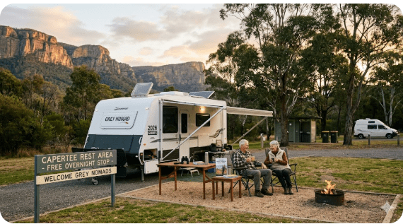
Capertee Rest Area is a free roadside rest area located on the Castlereagh Highway in Capertee, NSW 2846, approximately 50 kilometres north of Lithgow and roughly 55 kilometres south of Rylstone. Positioned at the entrance to the Capertee Valley — recognised as one of the largest enclosed valleys in the world — this stop provides grey nomads, caravanners, and long-distance travellers with a legal, free overnight rest point on the main inland highway route between Lithgow and Mudgee. The rest area is on a sealed road, accessible to caravans and motorhomes, and sits within a striking natural landscape flanked by sandstone escarpments and open valley farmland.
📋 Table of Contents
- Why Grey Nomads Stop at Capertee Rest Area
- Free Camping — Know the Rules for Seniors
- Quick Facts and Key Details 2026
- How to Get There + GPS Coordinates
- Road Conditions, Flooding and Sealed vs Unsealed
- Heat, Cold and Remoteness — Senior Considerations
- Wildlife — Birds, Reptiles and What to Watch For
- What Other Websites Don’t Tell You
- Best Time to Visit — Month-by-Month Breakdown
- Free and Low-Cost Camping Alternatives Nearby
- Dump Points Near Capertee
- Free Water Sources Near Capertee
- Fuel Stops Along the Castlereagh Highway
- Caravan Parks and Paid Alternatives Nearby
- Full Facilities Comparison Table
- Rates — All Options Near Capertee 2026
- Senior Safety Checklist — On and Off the Road
- What to Do Near Capertee — Senior Activity Guide
- Vanlife Savings Spots — GPS Coordinates and Postcodes
- Phone Signal and Emergency Communications
- Campfires, Cooking Restrictions and Food Near Capertee
- Pets at Capertee Rest Area
- Accessibility for Seniors with Mobility Limitations
- Permits, Fees, Etiquette and Waste Management
- Emergency Scenarios — What to Do
- Packing List for This Section of the Castlereagh Highway
- 5 Rest Areas Near Capertee on the Castlereagh Highway
- Reviews — What Grey Nomads Say
- Frequently Asked Questions
- Quick-Reference Card
- Disclaimer
Why Grey Nomads Stop at Capertee Rest Area
The Castlereagh Highway is the primary inland route connecting Lithgow on the Great Western Highway with Mudgee, Coonabarabran and the central-west regions of NSW. It is a well-travelled route for grey nomads moving between the Blue Mountains region and the New South Wales outback, wine regions, and the Warrumbungles.
Capertee Rest Area sits roughly halfway between Lithgow and Rylstone, making it a logical and practical overnight stop for travellers who have crossed the Blue Mountains or who are heading south toward Sydney. The stop also positions you perfectly for an early morning exploration of the Capertee Valley, the Capertee National Park, or the nearby Gardens of Stone National Park — all before the summer heat sets in.
Unlike some remote rest areas, Capertee is a well-established community with a general store (verify opening hours locally before relying on it), and the nearby Capertee Valley has a loyal following among birders, photographers and bushwalkers. Many grey nomads use this stop as a base for a night or two before continuing north or south.
From a budget perspective, staying at Capertee Rest Area rather than checking into a caravan park in Lithgow or Rylstone can save travellers roughly $30–$55 per night depending on the season — a meaningful saving for long-term travellers on a fixed income.
Free Camping — Know the Rules for Seniors
Capertee Rest Area is a NSW roadside rest area managed under Transport for NSW guidelines. As with all designated NSW roadside rest areas, overnight stays are permitted for the purpose of driver fatigue management, with a general limit of up to 20 hours in any 24-hour period.
There are no booking requirements and no fees for using the rest area. You simply pull in, rest, and move on. The rest area is open 24 hours, 7 days a week.
Grey nomads travelling the Castlereagh Highway regularly use this stop as a legal overnight rest point while travelling between the Blue Mountains and the central-west or north-west NSW regions. By late afternoon on weekdays, it’s not uncommon to see two to four caravans or motorhomes parked up for the night. On long weekends and school holiday periods, numbers can be higher.
Quick Facts and Key Details 2026
| Detail | Information |
|---|---|
| Location | Castlereagh Highway, Capertee NSW 2846 |
| Region | Lithgow Local Government Area, Central Tablelands NSW |
| Cost | Free |
| Maximum Stay | Up to 20 hours (NSW roadside rest area rule) |
| Road Type | Sealed — Castlereagh Highway (State Highway) |
| Access for Caravans | Yes — suitable for caravans and motorhomes |
| Heavy Vehicles | Yes — rest area designed for heavy vehicles |
| Toilets | Pit/composting toilet on site (verify condition on arrival) |
| Potable Water | Not supplied — BYO water |
| Power | No powered sites |
| Dump Point | Not on site — nearest in Lithgow or Rylstone |
| Distance from Lithgow | Approximately 50 km north via Castlereagh Highway |
| Distance from Rylstone | Approximately 55 km south via Castlereagh Highway |
| Distance from Mudgee | Approximately 100 km north via Castlereagh Highway |
| Phone Signal | Limited — Telstra generally better; signal can be patchy in the valley |
| Fires | Not permitted at the rest area |
| Pets | Permitted on lead at the rest area (not in adjacent national parks) |
| Nearby Attraction | Capertee National Park, Gardens of Stone NP, Capertee Valley birding |
| Postcode | 2846 |
How to Get There + GPS Coordinates
📍 GPS Coordinates — Capertee Rest Area
Approximate: -33.147, 149.987
⚠️ GPS coordinates for roadside rest areas can vary slightly depending on the mapping source. Always confirm your approach via Google Maps before travel and look for the designated rest area signage on the Castlereagh Highway at Capertee. Do not rely solely on any single coordinate source — verify against live mapping before departure.
📍 Search: “Capertee Rest Area NSW” in Google Maps or Apple Maps for the most current pin location.
Driving Directions — From the South (Lithgow)
From Lithgow, take the Castlereagh Highway heading north. The highway climbs through the lower Blue Mountains escarpment country before descending into the Capertee Valley. The drive is approximately 50 km and takes around 40–45 minutes in normal conditions. The Capertee Rest Area is signed on the highway — watch for the standard blue and white NSW rest area signage as you enter the township area of Capertee.
Driving Directions — From the North (Rylstone / Mudgee)
From Rylstone, travel south on the Castlereagh Highway for approximately 55 km. From Mudgee, travel south on the Castlereagh Highway for approximately 100 km. The highway through this section is sealed and generally in reasonable condition, though some sections have road surface wear — travel at appropriate speeds and watch for livestock and kangaroos, particularly at dusk and dawn.
Suitability for Different Vehicles
| Vehicle Type | Suitability | Notes |
|---|---|---|
| Car + Caravan | ✅ Suitable | Sealed highway access, wide pull-in area |
| Motorhome (Class A/C) | ✅ Suitable | Good turning space reported; confirm dimensions on arrival |
| Campervan / Van Conversion | ✅ Suitable | No restrictions |
| Truck / Heavy Vehicle | ✅ Designed for HV | Standard NSW heavy vehicle rest area |
| 5th Wheeler / Large Rig | ⚠️ Use caution | Check turning circle and available space on arrival |
| 2WD Vehicle | ✅ Suitable | Castlereagh Highway is sealed |
Road Conditions, Flooding and Sealed vs Unsealed Sections
The Castlereagh Highway — Lithgow to Capertee
The Castlereagh Highway between Lithgow and Capertee is a sealed state highway and is generally trafficable in all weather conditions for standard vehicles and caravans. However, sections of the highway pass through valleys and lower-lying areas that can be affected by heavy rain events.
Checking Road Conditions Before You Travel
- Check NSW Live Traffic — the official NSW road conditions resource
- Check Bureau of Meteorology for weather forecasts for the Lithgow and Central Tablelands region
- Local Lithgow Council may post road alerts on their website for local roads
Unsealed Roads Around Capertee
The Castlereagh Highway through Capertee village is sealed. However, if you intend to explore the Capertee Valley more broadly — including access to the Capertee National Park or surrounding state forest and fire trail roads — many of these side roads are unsealed gravel or dirt tracks.
Country Gates — Know the Rules
If you explore any private or state forest roads near Capertee that have gates, follow the standard country gate rules:
- If the gate is open — drive through and leave it open
- If the gate is closed — open it, drive through and close it behind you
- If the gate is closed and locked — do not force it open. A locked gate means no access
Heat, Cold and Remoteness — Senior Considerations
The Capertee Valley sits at an elevation of approximately 500–600 metres above sea level. This means it has a distinctly different climate to coastal NSW. Summers can bring genuinely hot days, while nights — even in summer — can cool rapidly after sunset. Winter nights in the valley can be cold enough for frost.
Remoteness and Self-Sufficiency
Capertee is a small rural community, not a major service town. While there is a small local store (trading hours are limited and variable — do not rely on it for essential supplies without confirming in advance), the nearest major services are in Lithgow to the south and Rylstone or Mudgee to the north.
- Carry sufficient water: No potable water is supplied at the rest area. Carry a minimum of 10–15 litres per person per day in hot weather
- Fuel up before you arrive: The nearest reliable fuel is in Lithgow (~50 km south) or Rylstone (~55 km north). Do not assume fuel is available in Capertee itself
- Tell someone your plans: Let a responsible person know your travel itinerary and expected next check-in point before entering remote areas around Capertee
- Carry a first aid kit: The nearest hospital is in Lithgow
Wildlife — Birds, Reptiles and What to Watch For
The Capertee Valley is internationally recognised as one of the finest birdwatching locations in Australia. It holds the largest known population of the Regent Honeyeater — a critically endangered species — and is a significant site for the Swift Parrot, also critically endangered. Birdwatchers travel from across Australia and internationally to visit the Capertee Valley specifically for these birds.
Key Bird Species to Watch For
- Regent Honeyeater (critically endangered — rare sighting)
- Swift Parrot (critically endangered — seasonal visitor)
- Gang-gang Cockatoo
- Superb Lyrebird (in forested gully areas)
- Painted Honeyeater
- Brown Treecreeper
- Various thornbills, wrens and honeyeaters
- Wedge-tailed Eagle — regularly seen soaring over the valley
Reptiles and Ground Animals
- Eastern Brown Snake: Present in the area. Highly venomous. Watch where you step, especially in warm months
- Blue-tongue Lizard: Common and harmless. Often seen basking on warm bitumen edges
- Lace Monitor: Large monitor lizards can be seen near campsites and picnic areas
- Red-necked Wallaby and Eastern Grey Kangaroo: Common in the valley. Active at dawn and dusk — major road hazard
- Wombat: Present in the forested areas around the valley
What Other Websites Don’t Tell You
Most listing sites — including CamperMate and WikiCamps — provide basic details like GPS pins and a quick photo. Here’s what they typically miss for senior travellers:
- The toilet situation: Rest area toilets at smaller stops like Capertee can be pit or composting style. They are typically cleaned on a council or Transport for NSW maintenance schedule, but cleanliness is variable. Carry your own toilet paper and hand sanitiser regardless
- No water whatsoever: This is not listed prominently on most sites. There is no potable water tap at the rest area. This is non-negotiable — carry all your own water
- The valley flood risk: The valley floor can hold water after prolonged rain. If you’re camping in winter during a wet spell, the surrounding countryside can become soggy. The highway itself is elevated slightly, but approach roads to other areas may not be
- The noise factor: The Castlereagh Highway carries both local and long-distance truck traffic. Rest areas adjacent to active highways can be noisy, particularly with heavy vehicles pulling in at night. Bring earplugs if you’re a light sleeper
- The cold at night: Even in spring and autumn, the Capertee Valley can drop to near-zero overnight temperatures. Experienced grey nomads who know the valley always pack an extra layer regardless of the season
- Phone signal is variable: Telstra has the best coverage in the area, but even Telstra can be patchy in the lower valley. Optus and Vodafone/TPG coverage drops significantly. Do not rely on mobile data for navigation or emergency calls without a backup plan
Best Time to Visit — Month-by-Month Breakdown
| Month | Weather | Best For | Watch Out For |
|---|---|---|---|
| January | Hot — 30–38°C days | Early morning birding | Heat stress, fire danger periods |
| February | Hot, some storms | Wildflowers beginning | Afternoon thunderstorms |
| March | Warm and settling | Excellent — mild days, cooler nights | School holiday traffic early March |
| April | Mild — 18–24°C | Peak autumn birding, scenic valley colour | Easter school holiday crowds |
| May | Cool — 12–20°C days | Excellent birding, quiet roads | Cold nights — below 5°C possible |
| June | Cold — frost possible | Quiet, atmospheric valley mornings | Freezing nights, frost on roads early |
| July | Cold — frost frequent | Clear skies, good photography | Ice on surfaces, cold van nights |
| August | Cold but improving | Start of spring bird activity | Still cold overnight |
| September | Warming — 16–24°C | Spring wildflowers, Regent Honeyeater activity | Some wet spells possible |
| October | Warm — 18–26°C | Peak birding season — highly recommended | School holidays — busier |
| November | Warm, some hot days | Good balance of warmth and activity | Increasing fire danger |
| December | Hot — summer setting in | Early morning visits only | School holidays, fire risk, heat |
Free and Low-Cost Camping Alternatives Nearby
🌿 Nearby Free Camps and Reserves Worth Considering
If the Capertee Rest Area is occupied or you need more space, these nearby options are worth considering. Always verify current conditions and access rules before arrival.
| Location | Type | Distance from Capertee | Notes |
|---|---|---|---|
| Ben Bullen Rest Area | Free roadside rest area | ~15 km south on Castlereagh Hwy | Smaller stop, suitable for overnight |
| Sunny Corner Recreation Reserve | Free forest camping | ~35 km south-east | Bush setting, limited facilities |
| Rylstone Showground | Showground camping (donation) | ~55 km north | Basic facilities; verify availability locally |
| Lake Windamere (near Mudgee) | Reserve camping area | ~80 km north | Near Windamere Dam; verify current rules |
| Portland Town Common | Free camping | ~45 km south via Castlereagh Hwy | Basic facilities, verify current access |
For a full list of rest areas and free camps in the Lithgow region, visit the hub guide at Rest Areas Lithgow — RetireToVanLife.com.
Dump Points Near Capertee
There is no dump point at Capertee Rest Area. The nearest verified dump points for grey nomads travelling this route are in Lithgow and Rylstone. Always verify current dump point availability using the resources below before travelling.
| Location | Distance from Capertee | Where to Find It | Cost |
|---|---|---|---|
| Lithgow (verify location via CamperMate) | ~50 km south | Check CamperMate or WikiCamps for current pin | Typically free (public) |
| Rylstone (verify location via CamperMate) | ~55 km north | Check CamperMate or WikiCamps for current pin | Typically free (public) |
| Mudgee (multiple options) | ~100 km north | Mudgee Visitors Centre area — check CamperMate | Typically free (public) |
Free Water Sources Near Capertee
There is no potable water supply at the Capertee Rest Area. This is the single most important practical fact for travellers using this stop. Do not arrive without sufficient water for your stay.
Nearest Water Sources
- Lithgow (~50 km south): Town water supply available at various public taps and facilities. Fill up before departing Lithgow heading north
- Rylstone (~55 km north): Town water available. Fill up here if travelling south
- Mudgee (~100 km north): Full facilities and water available
- Capertee township: There may be limited water available locally — do not rely on this without confirming in advance. It is a very small community
Fuel Stops Along the Castlereagh Highway
| Town / Stop | Direction from Capertee | Approximate Distance | Fuel Available |
|---|---|---|---|
| Lithgow | South | ~50 km | Yes — multiple service stations including major brands |
| Portland | South (via Castlereagh Hwy) | ~40 km | Limited — verify before relying on this stop |
| Rylstone | North | ~55 km | Yes — available in township |
| Kandos | North (adjacent to Rylstone) | ~55 km | Yes — available in township |
| Mudgee | North | ~100 km | Yes — full range of service stations |
| Glen Davis | West (via Glen Davis Rd) | ~35 km (unsealed section) | Very limited / not reliable — do not rely on |
Caravan Parks and Paid Alternatives Nearby
If the rest area is occupied, conditions aren’t suitable for a free overnight stop, or you simply prefer powered facilities, the following paid options are the nearest alternatives. Always confirm current pricing and availability directly with the park.
| Option | Location | Type | Approx Distance |
|---|---|---|---|
| Lithgow Caravan Park options | Lithgow NSW | Caravan park — powered & unpowered | ~50 km south |
| Rylstone Showground | Rylstone NSW | Showground — donation based | ~55 km north |
| Mudgee region caravan parks | Mudgee NSW | Multiple caravan parks — full facilities | ~100 km north |
| Kandos area | Kandos NSW | Limited options — verify locally | ~55 km north |
Free campsites and powered sites fill fast during school holidays and peak season. If your preferred site is already gone, search remaining accommodation options below to explore the region.
Accommodation and flight search powered by Expedia. Booking through this search supports this website at no extra cost to you. As an affiliate, I earn from qualifying purchases at no extra cost to you.
Full Facilities Comparison Table
| Facility | Capertee Rest Area | Lithgow Caravan Park | Rylstone Showground | Mudgee Caravan Parks |
|---|---|---|---|---|
| Cost per night | Free | $35–$55+ | Donation | $35–$65+ |
| Powered sites | ❌ | ✅ | ❌ (some may have) | ✅ |
| Toilets | ✅ (pit/basic) | ✅ (amenities block) | ✅ (basic) | ✅ (full) |
| Hot showers | ❌ | ✅ | ⚠️ (vary) | ✅ |
| Potable water | ❌ | ✅ | ✅ (verify) | ✅ |
| Dump point | ❌ | ✅ (most) | ⚠️ (verify) | ✅ |
| WiFi | ❌ | ⚠️ (some parks) | ❌ | ⚠️ (some parks) |
| Pet friendly | ✅ (on lead) | ⚠️ (park rules vary) | ✅ (generally) | ⚠️ (park rules vary) |
| Heavy vehicle access | ✅ | ✅ | ✅ | ✅ |
| Scenic setting | ✅ (valley views) | ⚠️ (urban) | ✅ (rural) | ✅ (wine country) |
Rates — All Options Near Capertee 2026
| Option | 2026 Rate (approx) | Notes |
|---|---|---|
| Capertee Rest Area | Free | Up to 20 hours — no booking required |
| Ben Bullen Rest Area | Free | Roadside stop — basic facilities |
| Rylstone Showground | Donation (suggest $5–$15) | Basic facilities — verify availability |
| Lithgow Caravan Parks | $35–$55/night unpowered; $50–$70/night powered | Confirm current pricing directly with each park |
| Mudgee Caravan Parks | $40–$65/night unpowered; $55–$85/night powered | Peak season pricing may be higher |
Senior Safety Checklist — On and Off the Road
Use this checklist before departing for and arriving at Capertee Rest Area. This is for reference — not a printable format.
- Fuel tank full before leaving Lithgow or Rylstone
- Fresh water tanks filled at last major town
- Sufficient food and snacks for overnight stay plus extra day
- Medications packed and accessible (not buried in storage)
- First aid kit stocked and accessible
- Someone at home knows your travel itinerary and next check-in time
- Weather forecast checked via BOM before departure
- NSW Live Traffic checked for road conditions
- Satellite communicator or personal locator beacon (PLB) packed if heading to remote areas
- Torch and spare batteries accessible
- Extra blankets and warm clothing for cold nights
- Toilet paper and hand sanitiser packed (rest area facilities are basic)
- Waste bags for grey water and rubbish management
- Solar panels working / battery charged
- Tyre pressures checked before departure
- Spare tyre in good condition and accessible
- Vehicle immobiliser or security device active (see StarterStopper below)
Exclusive Offer: Get 5% OFF all StarterStopper immobiliser products with promo code: RTV5
Visit StarterStopper.com to see our data-backed security solutions
As an affiliate, I earn from qualifying purchases at no extra cost to you.
What to Do Near Capertee — Senior Activity Guide
Capertee National Park
Capertee National Park borders the Capertee Valley and protects significant areas of sandstone escarpment, eucalypt woodland and riparian vegetation. Day-use access is available. The park does not have developed camping areas — the rest area on the highway is the designated overnight stop for travellers. Entry to the park for day use does not require payment at the Capertee end, but always check current NPWS rules via the NSW National Parks website as these can change.
Birdwatching in the Capertee Valley
The Capertee Valley is one of Australia’s premier birdwatching locations. Bring binoculars and a field guide. The area around the Capertee Village and the valley floor east of the township offers some of the best access for birdwatchers. Early morning — within the first two hours of sunrise — is the optimal time for bird activity.
Gardens of Stone National Park
Located to the south and east of Capertee, the Gardens of Stone National Park features spectacular pagoda rock formations — unusual sandstone formations that are unlike anything else in NSW. Day-use access is available from several points. The park is accessible from the Lithgow side as well. Check NPWS for current access details and any fee requirements.
Glen Davis — Historic Ghost Town
Glen Davis, approximately 35 km west of Capertee via the Glen Davis Road (partly unsealed — check conditions), is the site of a former oil shale processing town that operated in the mid-twentieth century. It’s a fascinating piece of Australian industrial history in a remote valley setting. The road to Glen Davis includes unsealed sections and is not recommended for caravans or large motorhomes — it suits 4WD vehicles or smaller campervans in dry conditions only.
Photography and Landscape
The Capertee Valley offers outstanding landscape photography opportunities. The sandstone escarpments that frame the valley — particularly the western wall — catch the early and late light dramatically. Sunrise and sunset from the valley floor are highly recommended if conditions are clear.
Fishing
The Capertee River and Coco Creek in the valley area can offer local fishing for native species. A valid NSW fishing licence is required for recreational fishing. Check current local fishing regulations via the NSW Department of Primary Industries.
🗺️ Vanlife Savings Spots — GPS Coordinates and Postcodes
Save every stop on your route through the Capertee Valley and the Lithgow region using the interactive Vanlife Savings Spots map below. Pin your own spots, add notes, and plan your next overnight stop — all in one place.
COPY PROMPT ➔ ASK AI ➔ SAVE TO FORM ➔ ADD SPOT PIN ➔ GET DIRECTIONS
📍 Interactive map — find free camps, rest areas and overnight stops. Enable location for best results.
| Location | Postcode | Approx GPS | Type | Notes |
|---|---|---|---|---|
| Capertee Rest Area | 2846 | ~-33.147, 149.987 | Free rest area | Castlereagh Hwy — verify GPS via Google Maps |
| Ben Bullen Rest Area | 2845 | Search Google Maps | Free rest area | ~15 km south on Castlereagh Hwy |
| Sunny Corner Rec Reserve | 2795 | Search Google Maps | Free forest camp | ~35 km south-east — bush setting |
| Portland Town Common | 2847 | Search Google Maps | Free camp | ~45 km south via Castlereagh Hwy |
| Rylstone Showground | 2849 | Search Google Maps | Showground/donation | ~55 km north — verify before arrival |
Phone Signal and Emergency Communications
Mobile phone coverage in the Capertee Valley is variable and should not be relied upon for emergency communications without a backup plan. The valley’s geography — enclosed by sandstone escarpments — can create coverage shadows even in areas that might otherwise receive reasonable signal.
| Carrier | Coverage at Capertee | Notes |
|---|---|---|
| Telstra | Generally best available | May be 1–2 bars — data may be slow or absent |
| Optus | Limited to patchy | May drop to no service in lower valley areas |
| Vodafone / TPG | Very limited | Do not rely on in this area |
Emergency Numbers
- 000 — Police, Ambulance, Fire (works on any carrier with any signal)
- 112 — Emergency number that works on mobile networks including when roaming
- Lithgow Hospital: (02) 6350 2300 — nearest major medical facility
- NSW SES: 132 500 — for flood or storm assistance
- NRMA Roadside Assistance: 13 11 11
Campfires, Cooking Restrictions and Food Near Capertee
Campfires
Open campfires are not permitted at the Capertee Rest Area. This is a roadside rest area on a state highway — fires of any kind in the rest area would be a safety hazard and are not appropriate.
Cooking at the Rest Area
Gas cooking from within your van, caravan or motorhome is the standard approach at this rest area. A small portable gas stove used responsibly outside on a calm day is generally acceptable when there is no Total Fire Ban in effect, but always check current conditions and use common sense. In high fire danger conditions, cook inside your vehicle.
Food Supplies Near Capertee
Capertee has very limited food purchasing options. The small general store in Capertee has historically provided basic supplies, but hours are variable and it may not always be open. Do not rely on Capertee for food resupply. Stock up thoroughly in Lithgow before heading north, or in Rylstone/Mudgee if heading south.
- Lithgow (~50 km south): Full supermarket options including Woolworths and Coles
- Rylstone (~55 km north): Small supermarket and local shops
- Mudgee (~100 km north): Full supermarket range and variety of food options
Pets at Capertee Rest Area
Pets are permitted at the Capertee Rest Area, subject to the standard requirements for pets in public places in NSW:
- Pets must be kept on a leash at all times at the rest area
- Clean up after your pet — pack waste bags and dispose of waste responsibly
- Do not leave pets unattended in vehicles in warm weather — temperatures can rise rapidly even with windows slightly open
- Pets are not permitted in adjacent national park areas (Capertee National Park, Gardens of Stone National Park) — check current NPWS pet policy before visiting these areas with animals
Accessibility for Seniors with Mobility Limitations
The Capertee Rest Area is a highway rest stop — it is not a fully accessible facility in the same way that a modern caravan park would be. Consider the following when planning your visit:
| Feature | Accessibility Status | Notes |
|---|---|---|
| Parking surface | Gravel / compacted surface | Generally level — may be uneven in spots |
| Toilet access | Basic pit or composting toilet | May not have handrails or accessible layout |
| Steps / kerbs | Minimal at rest area | Ground level access — no high kerbs reported |
| Lighting at night | Limited or none | Bring a torch — no overhead lighting at most rest stops |
| Surface for mobility aids | Gravel — may be challenging for wheelchairs | Not a purpose-built accessible facility |
| Distance to nearest accessible facilities | Lithgow ~50 km south | Full accessible facilities in Lithgow |
Permits, Fees, Etiquette and Waste Management
Permits and Fees
No permit or fee is required to use the Capertee Rest Area. It is a public NSW roadside rest area. Simply pull in and use the facilities.
Etiquette at the Rest Area
- Respect other travellers — keep noise to a reasonable level, especially in the evening
- Do not occupy more space than your vehicle requires — share the rest area with other travellers including heavy vehicles
- Do not dump grey water on the ground at the rest area — this is environmentally damaging and illegal
- Take all rubbish with you — there may be a bin at the rest area, but do not leave excess rubbish if the bin is full
- Do not block highway access for trucks — rest areas are designed for heavy vehicles and must remain accessible
- Keep your stay to the 20-hour NSW limit — do not treat a rest area as a multi-night free camping destination
Waste Management
Grey water and black water must be managed responsibly. The Capertee Rest Area has no dump point. Do not discharge waste water onto the ground, near the toilet, or into any drainage. Contain all waste and use the nearest dump point in Lithgow or Rylstone.
Emergency Scenarios — What to Do
Medical Emergency
Call 000 immediately. If mobile coverage is insufficient, drive toward Lithgow (south on the Castlereagh Highway) or toward Rylstone (north) until you gain signal. The nearest hospital is Lithgow Hospital — approximately 50 km south. Do not wait for signal to improve if the situation is life-threatening — get moving toward help.
Vehicle Breakdown
- Move your vehicle as far off the road as possible and deploy warning triangles or markers
- Call NRMA on 13 11 11 for roadside assistance — be aware that wait times in remote areas can be significant
- If you cannot move the vehicle safely off the highway, turn on hazard lights and exit the vehicle safely away from the traffic lanes
- Let someone know your situation — call a family member or contact point even if only a text message goes through
Flood or Road Closure
- Never drive through floodwater — even shallow-looking water can be faster and deeper than it appears
- Check NSW Live Traffic at livetraffic.com for current road closures
- If roads are closed, turn around and wait — do not attempt to bypass road closures
- Contact NSW SES on 132 500 if you require assistance due to flood
Bushfire
- Monitor the NSW RFS website and the Hazards Near Me app for current fire activity
- If you see smoke or a fire approaching, do not shelter in your caravan — leave immediately via the safest available road
- A caravan or motorhome offers very little protection from a fast-moving grassfire or bushfire
- Head for cleared areas or sealed roads away from the fire front
Packing List for This Section of the Castlereagh Highway
- Minimum 15–20 litres of drinking water per person (no water at rest area)
- 3 days of food supplies beyond what you need (don’t rely on Capertee township)
- Full fuel tank topped up at Lithgow or Rylstone
- Spare tyre and tyre repair kit
- Jump starter / battery pack
- Recovery tracks (if heading off sealed roads)
- PLB or satellite communicator
- Detailed paper map of the region (do not rely solely on mobile GPS)
- Torch and spare batteries
- Warm clothing and extra blankets (cold nights year-round)
- Sunscreen, hat and insect repellent
- Binoculars (Capertee Valley birding is outstanding)
- Camera and spare batteries / power bank
- Medications (sufficient supply plus extras)
- First aid kit
- Toilet paper and hand sanitiser
- Grey water containment and waste bags
- Fire extinguisher in vehicle
5 Rest Areas Near Capertee on the Castlereagh Highway
| # | Rest Area | Direction | Approx Distance | Key Notes |
|---|---|---|---|---|
| 1 | Ben Bullen Rest Area | South | ~15 km | Smaller roadside stop on Castlereagh Hwy |
| 2 | Lidsdale State Forest Rest Area | South | ~45 km | Bush setting near Lithgow — good alternative |
| 3 | Portland Town Common | South | ~45 km | Free camping — basic facilities |
| 4 | Rylstone area rest stops | North | ~55 km | Check CamperMate for current options near Rylstone |
| 5 | Sunny Corner Recreation Reserve | South-East | ~35 km | Forest camping — check access road conditions |
Reviews — What Grey Nomads Say
“We pulled in here after crossing the mountains from Sydney — it was getting late and we needed a safe stop. The rest area is signed and easy to pull into with the van. A bit of truck noise in the night but nothing we couldn’t sleep through. Toilet was basic but fine. Would use it again heading north.”
“The valley views in the morning were stunning — we hadn’t really appreciated what we were stopping in the middle of until sunrise lit up the escarpment. Cold night in June — very cold. Pack blankets. Bird noise at dawn was incredible, even from the rest area itself. Highly recommend as a stop for anyone who appreciates the natural setting.”
“No water and the toilet was a bit rough but it does the job. We were just passing through and needed somewhere to sleep before pushing on to Coonabarabran. For a free stop it’s fine. Fill up in Lithgow — don’t expect anything in Capertee itself.”
Frequently Asked Questions
Is the Capertee Rest Area free to use?
Yes. The Capertee Rest Area is a free NSW roadside rest area on the Castlereagh Highway. No booking or fee is required. Overnight stays of up to 20 hours are permitted under NSW roadside rest area guidelines.
Is there a toilet at the Capertee Rest Area?
A basic pit or composting toilet is generally available at the rest area. Bring your own toilet paper and hand sanitiser as supplies are not provided and cleanliness varies.
Is there water at the Capertee Rest Area?
No. There is no potable water supply at the rest area. Fill your water tanks at Lithgow before heading north, or at Rylstone before heading south.
Can I camp for multiple nights at Capertee Rest Area?
No. NSW roadside rest areas are intended for short-term driver rest, not extended camping. The maximum stay is 20 hours in a 24-hour period. For longer stays in the area, use a designated campground or caravan park.
Is camping permitted in Capertee National Park?
Camping is not permitted within Capertee National Park. The park is available for day use. Use the designated Capertee Rest Area on the Castlereagh Highway for your overnight stop.
What is the best route from Sydney to Capertee?
From Sydney, the most common route is via the Great Western Highway to Lithgow, then north on the Castlereagh Highway to Capertee — approximately 180–200 km depending on your starting point in Sydney. The entire route is on sealed roads. Allow approximately 2.5–3 hours from western Sydney.
Is the road to Capertee suitable for caravans?
Yes. The Castlereagh Highway is a sealed state highway and is suitable for caravans and motorhomes. Some winding sections between Lithgow and Capertee require careful driving when towing — take your time on bends and be alert to road surface variations.
Is there phone coverage at Capertee?
Mobile coverage at Capertee is variable. Telstra generally provides the best coverage in the area. Optus and Vodafone/TPG coverage is limited to patchy. Do not rely on mobile coverage for emergency communications without a backup plan such as a PLB or satellite communicator.
Is the Capertee Rest Area suitable for a 5th wheeler or large rig?
The rest area is designed as a highway heavy vehicle rest stop and should accommodate most large rigs. However, confirm turning space and available bay length on arrival. Very long combinations should proceed carefully.
Does the road to Capertee flood?
The Castlereagh Highway is generally not subject to frequent flooding, but the Capertee Valley floor can hold water in prolonged heavy rain events. Check NSW Live Traffic and BOM weather forecasts before travel, particularly in winter and spring wet weather periods.
Quick-Reference Card
📋 Capertee Rest Area — Quick Reference 2026
| Location | Castlereagh Highway, Capertee NSW 2846 |
| GPS (approx) | -33.147, 149.987 — verify via Google Maps before travel |
| Cost | Free |
| Max Stay | 20 hours (NSW roadside rest area) |
| Road | Sealed — Castlereagh Highway (State Highway) |
| Toilets | Basic pit/composting toilet — BYO paper & sanitiser |
| Water | None on site — fill up in Lithgow or Rylstone |
| Dump Point | None on site — Lithgow (~50 km south) or Rylstone (~55 km north) |
| Fuel (nearest) | Lithgow (~50 km south) or Rylstone (~55 km north) |
| Phone signal | Variable — Telstra best; patchy in valley |
| Fires | Not permitted at rest area |
| Pets | On lead — permitted at rest area |
| Emergency | 000 | Lithgow Hospital: (02) 6350 2300 |
| Road conditions | livetraffic.com | bom.gov.au |
| Fuel prices | petrolspy.com.au |
| Dump points | campermate.com.au |
- Lake Wallace (Wallerawang) free camping Lithgow NSW
- Lockyers Track Campground bush camping Lithgow NSW
- Londonderry Reserve free camp Lithgow NSW
- Sunny Corner Recreation Reserve forest camping Lithgow NSW
- Capertee Rest Area Lithgow NSW roadside stop
- Lidsdale State Forest Rest Area Lithgow NSW bush stop
- Marrangaroo Tunnel Hill Rest Area Lithgow NSW highway stop
- Meadow Glen Rest Area Lithgow NSW quiet stop
- Pearsons Lookout Rest Area Lithgow NSW scenic stop
- Ben Bullen Rest Area Lithgow NSW free stop
- Portland Town Common free camping Lithgow NSW
- Blackfellows Hand Rest Area Lithgow NSW historic site
Travelling from the USA? RV LIFE Trip Wizard
RV LIFE Trip Wizard is a USA-based RV trip planning tool designed for North American travellers. Australian grey nomads should use local tools such as WikiCamps, CamperMate and NSW Live Traffic for Australian route planning. If you’re a visiting American traveller, RV LIFE may be useful for your home-country travels.

As an affiliate, I earn from qualifying purchases at no extra cost to you.
The information in this guide was researched and compiled in good faith for the 2026 travel season. Road conditions, facility availability, dump point locations, fuel prices, campground fees and overnight stay rules can change without notice. Always verify current conditions via official sources — NSW Live Traffic (livetraffic.com), Bureau of Meteorology (bom.gov.au), and NSW National Parks and Wildlife Service — before departure. GPS coordinates provided are approximate and sourced from publicly available mapping data. Always confirm your GPS approach via live mapping before travel. RetireToVanLife.com accepts no liability for decisions made based on the information in this article. Travel safely and always carry appropriate safety equipment.
© 2026 RetireToVanLife.com — All rights reserved. Written for Senior Grey Nomads. Safe travels. 🚐