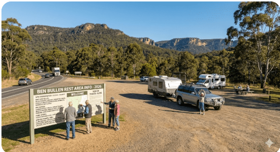
Ben Bullen Rest Area
Senior Grey Nomad Guide 2026 — GPS coordinates, day-use rules, road conditions, fuel stops, facilities breakdown, nearby alternatives and everything you need to plan a safe and informed stop on the Castlereagh Highway between Lithgow and Mudgee.
📅 Last reviewed: June 2026 | Castlereagh Highway, Ben Bullen NSW 2850 | Day-use only — no overnight camping
Ben Bullen Rest Area is a free, dog-friendly, day-use roadside rest stop located on the Castlereagh Highway, approximately 5 kilometres south of Cullen Bullen in the Lithgow region of New South Wales. Positioned between Lithgow to the south and Mudgee to the north, this rest area provides a practical break point for caravans, motorhomes and passenger vehicles travelling the Castlereagh Highway corridor. Day-use only — overnight camping and overnight parking are not permitted at this location.
📋 Table of Contents
- Why Grey Nomads Stop at Ben Bullen
- Day-Use Rules — What Seniors Need to Know
- Quick Facts and Key Details 2026
- How to Get to Ben Bullen Rest Area + GPS
- Road Conditions, Flooding and Sealed Surface
- Heat and Conditions — Senior Awareness
- Wildlife — What to Watch For
- What Other Websites Don’t Tell You
- Best Time to Travel This Section of Highway
- Overnight Alternatives Near Ben Bullen
- Dump Points Near Ben Bullen
- Water Sources in the Area
- Fuel Stops Along the Castlereagh Highway
- Caravan Parks — Paid Alternatives Nearby
- Full Facilities Comparison Table
- Rates — All Options Near Ben Bullen 2026
- Senior Checklist — Safety On and Off the Road
- What to Do Near Ben Bullen — Senior Activity Guide
- Vanlife Savings Spots — GPS Coordinates and Postcodes
- Phone Signal and Emergency Communications
- Campfires, Cooking and Food Nearby
- Pets at Ben Bullen Rest Area
- Accessibility for Seniors with Mobility Limitations
- Etiquette, Waste Management and Permits
- Emergency Scenarios — What to Do
- Packing List for the Castlereagh Highway
- 5 Rest Areas Near Ben Bullen
- Reviews — What Grey Nomads Say
- Frequently Asked Questions
- Quick-Reference Card
- Disclaimer
Why Grey Nomads Stop at Ben Bullen Rest Area
The Castlereagh Highway between Lithgow and Mudgee is a steady, rolling drive through Central Western NSW — scenic but without the density of roadside stops found on the major highways. Ben Bullen Rest Area sits at a natural break point on this route, roughly halfway through the climb and descent through the ranges above the Capertee Valley region.
For senior travellers hauling a caravan north toward Mudgee or south toward Lithgow and the Blue Mountains, this rest area provides a safe, no-cost opportunity to stop the vehicle, stretch, walk the dog, use basic facilities and re-assess how you’re feeling before continuing. The road can be demanding in sections — it undulates significantly and demands driver attention, making a planned rest break genuinely worthwhile.
The area also attracts travellers doing longer loops — those heading from the Blue Mountains across to Mudgee, then north toward Dunedoo or Gilgandra, or south back down through Bathurst. Ben Bullen marks the start of the more elevated, forested country north of Lithgow, and the air and scenery change noticeably as you climb.
Day-Use Rules — What Seniors Need to Know
As with all NSW highway rest areas managed under Roads and Maritime Services guidelines, Ben Bullen Rest Area is intended as a fatigue management stop. It is not a campground and is not managed by National Parks or a council with camping provisions.
Key rules at this rest area:
- Day use only — no overnight stays or camping
- No fires permitted
- Dogs are permitted on leash
- Pack out all rubbish — there may or may not be bins present; do not assume
- No generators running during rest periods
- Respect other travellers’ space — this is a shared stop
Quick Facts and Key Details 2026
| Detail | Information |
|---|---|
| Rest Area Name | Ben Bullen Rest Area |
| Highway | Castlereagh Highway |
| Nearest Town | Cullen Bullen (approx. 5 km north) |
| Region | Lithgow Local Government Area, NSW |
| Postcode Area | NSW 2850 (Mudgee region) / near 2790 (Lithgow boundary) |
| GPS Coordinates | Approximately -33.175, 149.945 (see GPS section for detail) |
| Cost | Free |
| Overnight Stay | Not permitted — day use only |
| Toilets | Pit toilet / basic facilities reported — verify on arrival |
| Running Water | Not available — carry your own |
| Bins | Not guaranteed — carry rubbish out |
| Dogs | Permitted on leash |
| Road Surface | Sealed highway access — Castlereagh Highway is sealed bitumen |
| Caravan Access | Yes — suitable for caravans and motorhomes off sealed highway |
| Fires | Not permitted |
| Phone Signal | Patchy — Telstra generally better in this region; verify with carrier |
How to Get to Ben Bullen Rest Area + GPS
📍 GPS Coordinates — Ben Bullen Rest Area
Approx. -33.175, 149.945
Castlereagh Highway, Ben Bullen NSW — approximately 5 km south of Cullen Bullen township.
Google Maps: Open in Google Maps
⚠️ Coordinates are approximate. Verify your position as you approach — the rest area is signed from the highway. GPS accuracy at this location is expected to be within approximately 100 metres. Always use road signage to confirm your turn-off.
Approaching from Lithgow (Southbound to Northbound — heading toward Mudgee)
From Lithgow, take the Castlereagh Highway heading north-west. The route climbs out of the Lithgow township through Wallerawang and then continues north-west through Capertee and Ben Bullen. The drive from Lithgow to Ben Bullen is approximately 35–40 kilometres and takes around 30–35 minutes under normal conditions. Watch for the rest area signage on the left-hand side as you travel north along the highway. The rest area is positioned on the highway before you reach Cullen Bullen village.
Approaching from Mudgee (Northbound to Southbound — heading toward Lithgow)
From Mudgee, head south on the Castlereagh Highway. The drive from Mudgee to Ben Bullen is approximately 65–70 kilometres and takes around 55–65 minutes. Cullen Bullen is the first main reference point — Ben Bullen Rest Area sits approximately 5 kilometres south of the Cullen Bullen township. Watch for highway signage indicating the rest area on the right-hand side when travelling south.
Vehicle Suitability
- ✅ Passenger vehicles — suitable
- ✅ Caravans and motorhomes — suitable (sealed highway access)
- ✅ Large motorhomes and camper trailers — suitable with care
- ✅ Heavy vehicles — this is a designated highway rest area suitable for trucks
- ❌ No off-road access required — road is sealed
Road Conditions, Flooding and Sealed Surface
The Castlereagh Highway from Lithgow north through Ben Bullen and Cullen Bullen to Mudgee is a sealed, two-lane bitumen road maintained by Transport for NSW (formerly Roads and Maritime Services). The highway is generally in reasonable condition, though it passes through elevated country that can be affected by frost in winter and occasional flooding in low-lying sections after heavy rain.
Does the Road Flood?
Low-lying sections of the Castlereagh Highway in the Capertee Valley area can be subject to flooding after significant rainfall events. The Ben Bullen locality sits at a higher elevation than the valley floor, reducing but not eliminating flood risk in the immediate area. Always check road conditions before departure during or after heavy rainfall.
Check live NSW road conditions before travelling: livetraffic.com (NSW Live Traffic — official)
Check the Bureau of Meteorology weather forecast for the Lithgow and Mudgee region before your trip: bom.gov.au
Is Any Section Unsealed?
The Castlereagh Highway itself is fully sealed from Lithgow through to Mudgee. There are no unsealed sections on the main highway route that travellers using Ben Bullen Rest Area will need to navigate. Side roads branching off toward state forests or properties in the area may be unsealed — stick to the highway and you will remain on sealed road.
Heat and Conditions — Senior Awareness
While the Ben Bullen area is not as remote or as hot as outback NSW, summer days can still reach into the mid-to-high 30s Celsius, and the rest area offers limited shade. In January and February, midday stops here can be uncomfortable without shade management — a portable awning or vehicle shade setup is worth having.
Winter mornings in this elevated country can be genuinely cold — below zero temperatures are not unusual in June and July. The rest area is exposed and offers no shelter from the wind. If you’re stopping here on a winter morning for a break, be prepared for cold.
- Carry a minimum 4 litres of drinking water per person when travelling this highway
- In summer, keep electrolyte sachets accessible
- In winter, carry a spare warm layer accessible in the cab — not buried in the van
- Use sunscreen at any rest stop — UV levels in central NSW are high year-round
- Seniors with heart or blood pressure conditions: hot vehicles after a rest stop can spike readings — cool the vehicle before re-entering
Wildlife — What to Watch For
The Ben Bullen and Cullen Bullen area sits on the edge of farmland and eucalyptus bush country. The Castlereagh Highway through here cuts through terrain that supports a range of native wildlife — much of which becomes road-active at dawn and dusk.
Common Wildlife in the Area
- Eastern grey kangaroos — highly active at dawn and dusk along the highway verges; a genuine collision risk
- Wallabies — smaller than kangaroos but equally unpredictable near roads
- Wombats — slower moving but very solid; a collision can cause serious vehicle damage
- Echidnas — may cross roads slowly; give them room
- Eastern brown snakes — active in warmer months; watch when walking around rest areas, especially in long grass
- Blue-tongue lizards — slow-moving reptiles that may be near or under vehicles parked in the sun
- Wedge-tailed eagles — often feeding on road kill; can be startled into low flight when vehicles approach
- Cockatoos and galahs — large flocks can cross roads quickly and low; slow down if you see them
When walking your dog at the rest area, keep them on a short lead and check long grass for snakes — particularly in the warmer months from October through April.
What Other Websites Don’t Tell You
Most online listings for Ben Bullen Rest Area simply note its location and that it’s a day-use stop. What they don’t tell you is the practical detail that matters for senior travellers on this route:
- The rest area is near Ben Bullen township, not Cullen Bullen — despite the two names being commonly confused. Ben Bullen is the locality name; Cullen Bullen is the nearest village approximately 5 km further north. Don’t confuse the two when navigating.
- The Capertee Valley — one of the most spectacular natural features in NSW — is in the general area to the south-west. If you’re travelling this route, the valley detour via Capertee township is well worth considering. The Capertee Valley is reportedly the world’s largest enclosed valley by some measurements and is home to the critically endangered regent honeyeater. It is a worthwhile side trip.
- No powered sites, no hook-up, no water: This is a rest area only. Travellers who arrive expecting dump points, water or power will be disappointed. Plan your service stops in Lithgow or Mudgee.
- Truck traffic: The Castlereagh Highway carries agricultural and mining-related heavy vehicles. The rest area is shared with truck drivers who use it for fatigue management. This is normal — be courteous, allow space, and expect the rest area to be occupied at any time of day.
- No phone charging or powered facilities: If your devices need charging, plan around Lithgow or Mudgee. Solar charging while driving is your best option between towns.
Best Time to Travel This Section of Highway
| Month | Conditions | Senior Recommendation |
|---|---|---|
| January – February | Hot, dry. Can reach 35°C+. Fire risk elevated. | Travel early morning. Check Total Fire Ban days at RFS NSW. |
| March – April | Cooling, pleasant days. Autumn colour in some areas. | Excellent time to travel. Comfortable temperatures. Fewer school holiday crowds. |
| May – June | Cool to cold. Morning frost possible above 800m elevation. | Good travel period. Pack warm layers. Reduce speed on frosty mornings. |
| July – August | Cold. Sub-zero mornings common. Ice on road possible. | Caution with early starts. Delay driving until frost has cleared from road surface. |
| September – October | Warming. Spring wildflowers. Can have unsettled rain. | Good time to travel. Check rainfall and road conditions before departing. |
| November – December | Warming to hot. School holiday peak period. | Travel mid-week if possible. Rest area may be busier. Start early to avoid midday heat. |
Overnight Alternatives Near Ben Bullen
Since Ben Bullen Rest Area does not permit overnight stays, the following options are the most practical overnight solutions for grey nomads in this corridor:
🏕️ Capertee Rest Area
Located on the Castlereagh Highway near Capertee township, south of Ben Bullen. Check current overnight rules at this location before arrival — rest area rules can change. See our detailed guide: Capertee Rest Area Lithgow NSW.
🏕️ Portland Town Common
Portland is located south-east of this area, closer to Lithgow. The town common has historically provided a free or low-cost overnight option. Verify current conditions before arrival. Portland Town Common guide.
🏕️ Mudgee (approx. 65 km north)
Mudgee has multiple caravan parks and a well-established tourist infrastructure. If you’re planning to overnight anywhere after Ben Bullen when heading north, Mudgee is the clear target town with full facilities.
🏕️ Lithgow (approx. 35–40 km south)
Lithgow offers caravan parks and powered sites. If you’re heading south and need to stop before the Blue Mountains descent, Lithgow is the logical overnight base.
Also see our full list of rest areas in the Lithgow region:
- Lake Wallace (Wallerawang) free camping Lithgow NSW
- Lockyers Track Campground bush camping Lithgow NSW
- Londonderry Reserve free camp Lithgow NSW
- Sunny Corner Recreation Reserve forest camping Lithgow NSW
- Capertee Rest Area Lithgow NSW roadside stop
- Lidsdale State Forest Rest Area Lithgow NSW bush stop
- Marrangaroo Tunnel Hill Rest Area Lithgow NSW highway stop
- Meadow Glen Rest Area Lithgow NSW quiet stop
- Pearsons Lookout Rest Area Lithgow NSW scenic stop
- Ben Bullen Rest Area Lithgow NSW free stop
- Portland Town Common free camping Lithgow NSW
- Blackfellows Hand Rest Area Lithgow NSW historic site
Dump Points Near Ben Bullen
There is no dump point at Ben Bullen Rest Area. The nearest dump point options for grey nomads travelling this route are in Lithgow or Mudgee. Use the campermate app or the WikiCamps dump point locator to identify the current closest option:
- Campermate.com.au — search dump points near your current location
- WikiCamps Australia — user-reported dump points across NSW
Water Sources in the Area
There is no potable water supply at Ben Bullen Rest Area. This is a basic highway rest stop — carry all your own water. For a two-person setup, a minimum of 8–10 litres for the day is recommended when travelling in this region, with more in summer.
Nearest Water Refill Options
- Cullen Bullen township (approx. 5 km north) — small community; verify availability of public water access locally
- Lithgow (approx. 35–40 km south) — full town amenities, multiple refill options
- Mudgee (approx. 65–70 km north) — full town amenities, visitor park facilities
Fuel Stops Along the Castlereagh Highway
Fuel planning is important on the Castlereagh Highway. This is not a major freight corridor with frequent fuel stops — there are significant gaps between reliable fuel sources.
| Location | Direction from Ben Bullen | Approx. Distance | Notes |
|---|---|---|---|
| Cullen Bullen | North (toward Mudgee) | ~5 km | Small community. Verify fuel availability before relying on this stop — it is a small village and fuel availability may be limited or have restricted hours. |
| Lithgow | South | ~35–40 km | Full range of fuel options. Multiple service stations. Recommended fuel-up point before heading north. |
| Mudgee | North | ~65–70 km | Full range of fuel. Major regional centre — all fuel types available. |
| Rylstone | North (between Cullen Bullen and Mudgee) | ~35–40 km north of Cullen Bullen | Small town with fuel. Useful intermediate stop if needed. Verify hours. |
Caravan Parks — Paid Alternatives Nearby
For travellers who prefer a powered site with full amenities, the following options are the closest to Ben Bullen Rest Area. Pricing is indicative only — always verify directly with the facility before arrival.
| Option | Location | Distance from Ben Bullen | Type | Est. Cost 2026 |
|---|---|---|---|---|
| Mudgee Riverside Caravan Park | Mudgee NSW | ~65–70 km north | Powered sites, facilities | ~$40–$55/night (verify directly) |
| Lithgow Tourist Caravan Park | Lithgow NSW | ~35–40 km south | Powered sites, amenities | ~$35–$50/night (verify directly) |
| Rylstone Caravan Park area | Rylstone NSW | ~35–40 km north of Cullen Bullen | Basic facilities — verify current operation | Verify locally |
Free campsites and powered sites fill fast during school holidays and peak season. If your preferred site is already taken, search remaining accommodation options in the Lithgow or Mudgee region below.
Accommodation and flight search powered by Expedia. Booking through this search supports this website at no extra cost to you. As an affiliate, I earn from qualifying purchases at no extra cost to you.
Full Facilities Comparison Table
| Facility | Ben Bullen Rest Area | Capertee Rest Area | Mudgee Caravan Park | Lithgow Caravan Park |
|---|---|---|---|---|
| Cost | Free | Free | ~$40–$55/night | ~$35–$50/night |
| Overnight Stay | ❌ Not permitted | Check current rules | ✅ Yes | ✅ Yes |
| Toilets | Basic pit toilet (verify) | Basic (verify) | ✅ Full amenities | ✅ Full amenities |
| Running Water | ❌ No | ❌ No | ✅ Yes | ✅ Yes |
| Power | ❌ No | ❌ No | ✅ Yes (powered sites) | ✅ Yes (powered sites) |
| Dump Point | ❌ No | ❌ No | ✅ Yes | ✅ Yes |
| Dog Friendly | ✅ Yes (on leash) | ✅ Yes (on leash) | Check with park | Check with park |
| Sealed Road Access | ✅ Yes | ✅ Yes | ✅ Yes | ✅ Yes |
| Caravan Suitable | ✅ Yes | ✅ Yes | ✅ Yes | ✅ Yes |
| Fires | ❌ Not permitted | Check local rules | Check with park | Check with park |
| WiFi | ❌ No | ❌ No | Check with park | Check with park |
| Phone Signal | Patchy — Telstra best | Patchy | ✅ Town coverage | ✅ Town coverage |
Rates — All Options Near Ben Bullen 2026
| Option | Type | Cost Per Night 2026 | Notes |
|---|---|---|---|
| Ben Bullen Rest Area | Day use only | Free | No overnight stays permitted |
| Capertee Rest Area | Rest area | Free | Verify overnight rules on arrival |
| Portland Town Common | Free/donation camp | Free or donation | Verify current status before arrival |
| Lithgow Caravan Park options | Powered site | ~$35–$50/night est. | Verify directly with facility |
| Mudgee Caravan Park options | Powered site | ~$40–$55/night est. | Verify directly with facility |
Senior Checklist — Safety On and Off the Road
- Water tanks and drinking water checked and topped up before leaving last town
- Fuel tank level confirmed — don’t leave Lithgow or Mudgee below half a tank when towing
- Phone charged and in reach of driver
- Next overnight stop planned and confirmed (not Ben Bullen — day use only)
- Dump point planned if tanks approaching capacity
- Road conditions checked at livetraffic.com
- Weather forecast checked at bom.gov.au
- Medications accessible — not buried in storage
- Responsible person notified of travel plan and expected arrival time
- Warm layer accessible in cab for cold-morning starts
- Dog water bowl and lead accessible for rest stops
- Sunscreen applied before leaving the vehicle at rest stops
- Fatigue check — if feeling tired, stop at Ben Bullen rather than pushing on
- Caravan hitching and lights checked after every rest stop before re-entering highway
- Speed reduced for dawn and dusk sections — kangaroo risk is high on this highway
What to Do Near Ben Bullen — Senior Activity Guide
The Ben Bullen and Cullen Bullen area is not a tourist hub in itself, but it sits within reach of several genuinely worthwhile attractions for senior travellers who want to explore the region rather than simply pass through.
Capertee Valley
Located to the south-west, the Capertee Valley is one of the great natural spectacles of Central NSW. Described by some as the world’s largest enclosed valley, it sits between towering sandstone walls and contains a variety of wildlife including the critically endangered regent honeyeater. The valley floor is accessible via sealed road through Capertee township. Birdwatching is excellent here — bring binoculars. The light in the late afternoon is spectacular against the cliffs.
Glen Davis
At the northern end of the Capertee Valley, the historic shale oil town of Glen Davis is a fascinating detour. The ruins of the old oil works are a reminder of a remarkable industrial experiment in the mid-20th century. The road to Glen Davis is sealed to the township. Glen Davis is approximately 40 km from Capertee on a scenic sealed road — check road conditions before departure.
Mudgee Wine Region
Mudgee, approximately 65–70 km north of Ben Bullen via the Castlereagh Highway, is one of NSW’s best-known wine regions. For senior travellers, several cellar doors offer seated tastings and are accessible without walking long distances. Mudgee also has an excellent main street with cafes, produce stores and a strong local food culture.
Lithgow and surrounds
South of Ben Bullen, Lithgow provides access to the Zig Zag Railway experience, the Lithgow Blast Furnace heritage site, and the spectacular scenery of the Blue Mountains escarpment. For seniors, the Lithgow Information and Neighbourhood Centre is a good first port of call for local advice.
🗺️ Vanlife Savings Spots — GPS Coordinates and Postcodes
Use the interactive map below to save Ben Bullen Rest Area and nearby stops directly to your trip planner. Pin your next stop, get directions and compare options along the Castlereagh Highway corridor.
COPY PROMPT ➔ ASK AI ➔ SAVE TO FORM ➔ ADD SPOT PIN ➔ GET DIRECTIONS
📍 Interactive map — find free camps, rest areas and overnight stops. Enable location for best results.
| Location | Postcode | Approx. Latitude | Approx. Longitude | Notes |
|---|---|---|---|---|
| Ben Bullen Rest Area | ~2850 | -33.175 | 149.945 | Day use only. No overnight. |
| Cullen Bullen Village | 2790 | ~-33.138 | ~149.938 | Nearest township ~5 km north |
| Capertee township | 2846 | ~-33.177 | ~150.007 | Access point for Capertee Valley |
| Lithgow town centre | 2790 | ~-33.484 | ~150.158 | Full services — fuel, water, dump point |
| Mudgee town centre | 2850 | ~-32.596 | ~149.587 | Full services — fuel, water, caravan parks |
Phone Signal and Emergency Communications
Phone coverage in the Ben Bullen and Cullen Bullen area is patchy. Telstra’s network generally provides the most reliable rural coverage in this part of NSW. Optus and Vodafone coverage diminishes quickly outside of town centres on the Castlereagh Highway.
Emergency Communications Options
- Triple Zero (000) — always try this first. Emergency calls may connect on networks other than your own carrier’s.
- 112 — international emergency number; can connect via any available mobile network signal
- Personal Locator Beacon (PLB) — recommended for grey nomads travelling rural highways. Operates via satellite and does not require phone coverage. Register your PLB at beacons.amsa.gov.au
- Satellite communicators (e.g. Garmin inReach) — allow two-way text communication via satellite from any location
- UHF CB Radio Channel 40 — monitored by many truck drivers on this highway; useful for road condition updates and assistance alerts
Campfires, Cooking and Food Nearby
Campfires
Campfires are not permitted at Ben Bullen Rest Area. This is a managed highway rest stop — open fires are prohibited. During declared Total Fire Ban periods across the Lithgow and Greater Western region, even gas cookers may be subject to restrictions in some classifications. Check the NSW Rural Fire Service website for current fire danger ratings and Total Fire Ban declarations before your trip: rfs.nsw.gov.au
Cooking at the Rest Area
There are no BBQ facilities at Ben Bullen Rest Area. If you want to have a hot meal at this stop, a portable camp stove or a vehicle-mounted cooking setup is your only option. Be mindful of fire ban conditions when using gas cookers outdoors.
Food and Coffee Nearby
- Cullen Bullen (~5 km north) — very small community; limited food options. Do not plan a meal stop here without verifying current open businesses first.
- Lithgow (~35–40 km south) — full range of cafes, supermarkets and fast food on the Great Western Highway and main street.
- Mudgee (~65–70 km north) — excellent cafes, bakeries and restaurants on Market Street and surrounds. Mudgee is well worth a food stop.
- Rylstone (~35–40 km north of Cullen Bullen) — small town with a bakery and cafe options. A pleasant stop on the route to Mudgee.
Pets at Ben Bullen Rest Area
Dogs are permitted at Ben Bullen Rest Area. As a highway rest stop rather than a national park or reserve, standard leash rules apply. Keep dogs on a lead at all times — both for the safety of your pet and out of courtesy to other travellers sharing the rest area.
- ✅ Dogs permitted on leash
- ❌ No off-leash area
- ⚠️ Snake risk in warm months — keep dogs away from long grass and check their paws after walks
- ⚠️ Heat risk — the rest area may offer limited shade; monitor dogs carefully in summer temperatures
- Pack out all pet waste — use bags and take it with you
Accessibility for Seniors with Mobility Limitations
Ben Bullen Rest Area is a basic highway rest stop. It is unlikely to have dedicated accessible toilet facilities or specific accessibility infrastructure comparable to modern service centres. The following is a realistic assessment for senior travellers with mobility considerations:
| Consideration | Assessment |
|---|---|
| Parking surface | Likely gravel or compacted surface — not sealed. May be uneven. Verify on arrival. |
| Toilet access | Basic pit toilet if present — not designed for wheelchair access. Verify on arrival. |
| Ground conditions | May be uneven, loose gravel. Walking aids (cane/walker) may be needed on uneven surfaces. |
| Steps or obstacles | No infrastructure — open rest area. Ground level access to surroundings. |
| Shade | Limited — not guaranteed. Bring portable shade if needed. |
| Seating | May have a picnic table — not guaranteed. Bring portable seating. |
Etiquette, Waste Management and Permits
No Permit Required
No permit is required to stop at Ben Bullen Rest Area. It is a free, publicly accessible highway rest stop managed under NSW Transport roads infrastructure. Simply pull in, rest and depart.
Leave No Trace
- Pack out all rubbish — bins may not be present or may be full
- Take pet waste with you in sealed bags
- Do not dump grey water at the rest area — use a designated dump point
- Do not leave food scraps that attract wildlife to the road verge
- Keep noise to a minimum — especially if other travellers are resting
Shared Space Rules
- Truck drivers use this rest area for fatigue management — give them space and do not block access with your rig
- Park sensibly — leave room for other vehicles to enter and exit easily
- Generator use is inappropriate at a short rest stop where other travellers are trying to rest
Emergency Scenarios — What to Do
Medical Emergency
Call Triple Zero (000) immediately. If phone signal is unavailable, try 112. If you have a PLB or satellite communicator, activate it. Alert other travellers at the rest area for assistance. The nearest hospital is in Lithgow — approximately 35–40 km south on the Castlereagh Highway.
Vehicle Breakdown
If your vehicle breaks down at Ben Bullen Rest Area, you are in a safe, off-road location on the highway. Contact your roadside assistance provider (NRMA, RAA, etc.) and provide the GPS coordinates from this guide. Alert passing trucks via UHF Channel 40 if needed. Keep well clear of highway traffic.
Tyre Blowout or Mechanical Failure on the Highway
If you experience a tyre or mechanical failure while on the Castlereagh Highway, attempt to reach the Ben Bullen Rest Area if it is safe to do so — the rest area provides a safe, off-road location to assess and address the issue. If you cannot reach the rest area, pull as far off the sealed road as safely possible, engage hazard lights, and call for assistance.
Snake Bite
Eastern brown snakes are present in this region. In the event of a bite: immobilise the affected limb, apply a pressure immobilisation bandage, keep the casualty still and calm, call 000 immediately. Do not cut the wound, suck out venom, or apply a tourniquet. Do not attempt to identify or capture the snake.
Fire Emergency
If a bushfire is approaching your location, do not shelter in or under a caravan or tent. Remain in your vehicle with windows up, vents closed and engine off. Call 000 when safe to do so. If you have time to leave, leave early — do not wait until fire is visible before departing.
Packing List for the Castlereagh Highway
- Minimum 10 litres of drinking water per couple (more in summer)
- Food for at least one full day beyond planned arrival — delays happen
- Fuel — depart Lithgow or Mudgee with a full tank when towing
- Spare tyre in good condition — check before departure
- Tyre repair kit or inflation canister for emergencies
- Personal Locator Beacon (PLB) — registered with AMSA
- UHF CB Radio — set to Channel 40 when travelling
- First aid kit — fully stocked and accessible
- Snake bite bandages (3 × crepe bandages minimum)
- Medications — at least 7 days extra supply beyond planned travel
- Warm layers — accessible in cab, not in storage
- Sunscreen SPF 50+ and sunglasses
- Portable shade or awning for rest stops
- Portable seating — do not rely on rest area picnic tables being present
- Dog water bowl and extra lead
- Torch with fresh batteries
- Paper map of NSW (do not rely solely on phone GPS)
- Dump point and water refill locations noted for the route
- Emergency contact numbers saved offline on phone and written on paper
5 Rest Areas Near Ben Bullen — Castlereagh Highway
| Rest Area | Direction from Ben Bullen | Approx. Distance | Overnight? | Notes |
|---|---|---|---|---|
| Capertee Rest Area | South-east (toward Lithgow) | ~20–25 km | Verify on arrival | Castlereagh Hwy; near Capertee Valley access |
| Blackfellows Hand Rest Area | South (toward Lithgow) | ~30–35 km | Verify | Historic area; Castlereagh Hwy corridor |
| Meadow Glen Rest Area | South | Verify distance | Verify | Lithgow region; quiet stop |
| Lidsdale State Forest Rest Area | South (near Lithgow) | ~40+ km | Verify | Bush setting near Lidsdale; Lithgow area |
| Pearsons Lookout Rest Area | South | Verify distance | Verify | Scenic lookout stop; Lithgow region |
Reviews — What Grey Nomads Say About Ben Bullen Rest Area
“Pulled in here on our way up to Mudgee — perfect for a leg stretch and a coffee from the thermos. Basic facilities but it does the job. The scenery looking west toward the ranges is really pretty. Just don’t expect overnight to be on — it’s a day stop only and signage makes that clear.”
“Had a 20-minute break here with our cattle dog. She appreciated the stretch. Toilet block was basic but functional. Would have liked a bit more shade but the rest area itself is fine for what it is. Headed south to Lithgow after — good fuel stop there before the highway section.”
“Nice quiet rest area. We stopped mid-morning and it was just us and one truck. Easy to get the van in and out. Not a place to overnight — signs are very clear on that. But for a break, it’s exactly what you need on this stretch of road. The run up through the ranges is tiring on the driver.”
Frequently Asked Questions
Can I camp overnight at Ben Bullen Rest Area?
No. Ben Bullen Rest Area is a day-use only facility. Overnight camping and overnight parking are not permitted. For overnight options, see Section 10 of this guide.
Where exactly is Ben Bullen Rest Area?
Ben Bullen Rest Area is located on the Castlereagh Highway, approximately 5 kilometres south of Cullen Bullen village in the Lithgow Local Government Area of NSW. GPS coordinates are approximately -33.175, 149.945 — verify with road signage on approach.
Is the Castlereagh Highway sealed through Ben Bullen?
Yes. The Castlereagh Highway is fully sealed bitumen from Lithgow through Ben Bullen, Cullen Bullen and on to Mudgee. No unsealed road driving is required to access Ben Bullen Rest Area.
Does the road flood near Ben Bullen?
The Castlereagh Highway can be affected by flooding in low-lying sections, particularly in the Capertee Valley area to the south. Ben Bullen sits at higher elevation, reducing but not eliminating flood risk. Always check livetraffic.com before travelling after heavy rain.
Are dogs allowed at Ben Bullen Rest Area?
Yes, dogs are permitted at Ben Bullen Rest Area. Keep dogs on a lead at all times and clean up after your pet.
Is there a dump point at Ben Bullen Rest Area?
No. There is no dump point at this rest area. The nearest dump point options are in Lithgow (approximately 35–40 km south) or Mudgee (approximately 65–70 km north).
Is there water available at Ben Bullen Rest Area?
No potable water is available at Ben Bullen Rest Area. Carry all your own water. The nearest confirmed water sources are in Lithgow and Mudgee.
What phone signal can I expect at Ben Bullen?
Phone coverage is patchy in this area. Telstra generally provides the most reliable rural coverage. Do not rely on mobile coverage being available. Carry a PLB or satellite communicator if travelling this highway regularly.
Is Ben Bullen Rest Area suitable for large caravans?
Yes — the Castlereagh Highway is a sealed highway rest area accessible to caravans and large motorhomes. Entry and exit are straightforward. Allow sufficient space when manoeuvring and approach at a sensible speed.
How far is Ben Bullen Rest Area from Lithgow?
Ben Bullen Rest Area is approximately 35–40 kilometres from Lithgow via the Castlereagh Highway, taking approximately 30–35 minutes under normal driving conditions.
Quick-Reference Card
📋 Ben Bullen Rest Area — Quick Reference 2026
| Location | Castlereagh Highway, ~5 km south of Cullen Bullen NSW |
| GPS | Approx. -33.175, 149.945 |
| Cost | Free |
| Overnight Stay | NOT permitted — day use only |
| Dogs | Yes, on leash |
| Toilets | Basic pit toilet (verify on arrival) |
| Water | Not available — carry your own |
| Dump Point | Not available — use Lithgow or Mudgee |
| Fires | Not permitted |
| Road Surface | Sealed highway (Castlereagh Highway) |
| Phone Signal | Patchy — Telstra best; do not rely on coverage |
| Nearest Fuel | Lithgow ~35–40 km south; Mudgee ~65–70 km north |
| Nearest Town | Cullen Bullen ~5 km north |
| Emergency | Triple Zero (000) | PLB recommended |
| Road Conditions | livetraffic.com |
| Weather | bom.gov.au |
Exclusive Offer: Get 5% OFF all StarterStopper immobiliser products with promo code: RTV5
Visit StarterStopper.com to see our data-backed security solutions
As an affiliate, I earn from qualifying purchases at no extra cost to you.
Travelling from the USA? RV LIFE Trip Wizard is a USA-based RV trip planning tool
RV LIFE Trip Wizard is designed specifically for North American RV travellers and routes. It is not applicable for Australian travel planning, but if you’re heading back to the US or planning an American road trip, this tool is worth checking out.

As an affiliate, I earn from qualifying purchases at no extra cost to you.
⚠️ Disclaimer
The information in this guide is provided in good faith for general travel planning purposes. Road conditions, facility availability, overnight rules and access can change without notice. Always verify current conditions with the relevant authority before travel — including Transport for NSW, local councils, NSW National Parks and the NSW Rural Fire Service where applicable.
GPS coordinates in this guide are approximate and sourced from publicly available mapping data. They are intended as a guide only — always use road signage to confirm your location. Do not navigate solely by GPS coordinates in rural areas.
This website does not accept responsibility for decisions made based on information in this guide. Travel safely, plan ahead and always carry appropriate emergency equipment when travelling rural NSW highways.
External links are provided for convenience only. RetireToVanLife.com is not responsible for the content of external websites. Affiliate links are disclosed where applicable.
© 2026 RetireToVanLife.com — All rights reserved. Written for Senior Grey Nomads. Safe travels. 🚐