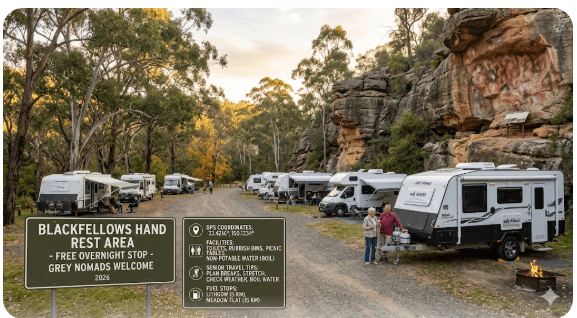
Blackfellows Hand Rest Area
Senior Grey Nomad Guide 2026 — GPS coordinates, road conditions, nearby fuel stops, facilities, cultural significance, wildlife and everything you need for a safe overnight stop near Lithgow on the Great Western Highway.
📅 Last reviewed: June 2026 | Lithgow Region, NSW 2790 | Free overnight stop — sealed highway
Blackfellows Hand Rest Area is a free roadside rest area located on the Great Western Highway (A32), approximately 3 kilometres east of Lithgow town centre in the Central Tablelands region of New South Wales, Australia. It sits on a key travel corridor connecting Sydney (approximately 150 km east) with Bathurst (approximately 65 km west), making it a practical and frequently used overnight stop for grey nomads, caravanners, and long-distance travellers heading in either direction. The rest area takes its name from a significant Aboriginal rock art site in the surrounding area — a hand stencil formation of recognised cultural heritage importance to the Wiradjuri people. For senior travellers in 2026, this stop offers a free, sealed-access pull-off on a major highway with Lithgow’s full services — fuel, food, medical, and waste disposal — located just minutes away.
📋 Table of Contents
- Why Grey Nomads Stop at Blackfellows Hand Rest Area
- Free Camping — Know the Limits for Seniors
- Quick Facts and Key Details 2026
- How to Get There + GPS Coordinates
- Road Conditions, Flooding and Unsealed Sections
- Cultural Significance — Blackfellows Hand Rock Art
- Weather, Cold and Elevation — Seniors Be Prepared
- Wildlife — Birds, Reptiles and What to Watch For
- What Other Websites Don’t Tell You
- Best Time to Visit — Month-by-Month Breakdown
- Free and Low-Cost Camping Alternatives Nearby
- Dump Points Near Blackfellows Hand Rest Area
- Water Sources Near Lithgow
- Fuel Stops Along the Great Western Highway
- Caravan Parks — Paid Alternatives
- Full Facilities Comparison Table
- Rates — All Options Near Lithgow 2026
- Senior Safety Checklist — On and Off the Road
- What to Do Near Lithgow — Senior Activity Guide
- Vanlife Savings Spots — GPS Coordinates and Postcodes
- Phone Signal and Emergency Communications
- Campfires, Cooking Restrictions and Food Near Lithgow
- Pets at Blackfellows Hand Rest Area
- Accessibility for Seniors with Mobility Limitations
- Permits, Fees, Etiquette and Waste Management
- Emergency Scenarios — What to Do
- Packing List for This Section of Highway
- 5 Rest Areas Near Blackfellows Hand / Great Western Highway
- Reviews — What Grey Nomads Say
- Frequently Asked Questions
- Quick-Reference Card
- Disclaimer
Why Grey Nomads Stop at Blackfellows Hand Rest Area
The Great Western Highway between Sydney and Bathurst is one of the most heavily travelled inland routes in New South Wales. For senior travellers and grey nomads making their way west — or returning east after touring regional NSW — Blackfellows Hand Rest Area appears at exactly the right point along the journey.
Lithgow marks the transition from the steep Blue Mountains descent to the gentler Central Tablelands plateau. After the long climb and descent through the mountains, many drivers — particularly those towing caravans — are ready for a genuine rest before continuing west toward Bathurst, Orange, or beyond. This rest area is positioned to serve precisely that need.
Beyond the practical driving break, the area also carries genuine historical and cultural interest. The name “Blackfellows Hand” refers to Aboriginal hand stencil rock art associated with this stretch of the Central Tablelands. This gives the stop a layer of meaning that many highway pull-offs simply don’t have, and for senior travellers who appreciate history and Country, it adds value to the stop.
Lithgow is only approximately 3 km west of the rest area, meaning that if you need fuel, a hot meal, a dump point, or any supplies before settling in for the evening, the town is close enough that you won’t need to unhitch a caravan to access it. This makes Blackfellows Hand Rest Area one of the more convenient free overnight stops in the Lithgow corridor.
Free Camping — Know the Limits for Seniors
Blackfellows Hand Rest Area is a NSW roadside rest area managed to support driver fatigue programs on major highways. Under NSW Transport rules that apply to all roadside rest areas on the state highway network, the general maximum stay is 20 hours. This is not a designated campground — it is a formal rest area that permits overnight stays within that time limit.
There is no cost to use this rest area. It is free for all vehicles including caravans and motorhomes. However, because it is a rest area rather than a campground, facilities are basic. Do not expect powered sites, dump points on-site, or amenity blocks. Lithgow town, approximately 3 km away, provides all of those services.
For seniors planning a multi-night stay in the Lithgow region, it is worth considering the paid caravan park options in town or the nearby free camping alternatives listed later in this guide. The rest area is best used as a one-night stopover between driving stages — which is exactly what it was designed for.
Quick Facts and Key Details 2026
| Detail | Information |
|---|---|
| Full Name | Blackfellows Hand Rest Area |
| Highway | Great Western Highway (A32) |
| Nearest Town | Lithgow, NSW |
| Distance from Lithgow | Approximately 3 km east of Lithgow town centre |
| Postcode | 2790 |
| Coordinates (approx.) | -33.483°S, 150.176°E |
| Coordinate Source | Publicly available mapping data — Great Western Highway corridor |
| Cost | Free |
| Maximum Stay | 20 hours (NSW roadside rest area rule) |
| Road Surface | Fully sealed — Great Western Highway |
| Toilet Facilities | Not confirmed on-site — Lithgow 3km |
| Water On-Site | Not available — carry your own |
| Caravan Accessible | Yes — sealed entry, highway access |
| Heavy Vehicle Access | Yes |
| Pets | Permitted (on lead — rest area on highway) |
| Phone Signal | Generally good — Telstra and Optus coverage near Lithgow |
| Cultural Significance | Named for Aboriginal hand stencil rock art in the area |
| Elevation | Approximately 880–900m above sea level |
How to Get There + GPS Coordinates
📍 GPS Coordinates — Blackfellows Hand Rest Area
-33.483°S, 150.176°E
Coordinate source: Publicly available mapping — Great Western Highway, east of Lithgow NSW 2790
Note: Coordinates are approximate to the Great Western Highway corridor near this location. Use navigation with “Blackfellows Hand Rest Area, Lithgow NSW” as your search term to confirm the exact pull-in point for your GPS device.
Approaching from Sydney (eastbound to westbound)
Travel west along the Great Western Highway (A32) from Sydney through the Blue Mountains — Katoomba, Blackheath, Mount Victoria — descending into Lithgow. The rest area is situated on the eastern approach to Lithgow township, approximately 3 km before the main Lithgow services. Watch for highway rest area signage on your left (south side of highway) as you complete the descent.
The entry is off the sealed highway and suitable for caravans and motorhomes of standard size. The pull-off is a dedicated sealed area with enough space for several vehicles including those with large rigs. Turning space is adequate for most caravan combinations, though very large triple-axle setups should approach at low speed and assess before committing fully to the bay.
Approaching from Bathurst (westbound to eastbound)
Travel east along the Great Western Highway from Bathurst through Lithgow. Pass through the Lithgow town centre and continue east. The rest area will appear on your right (south side of highway) approximately 3 km east of central Lithgow. The highway rest area sign will be visible in advance, giving you time to slow safely and pull in. The approach from the west is straightforward and well-suited to caravans and motorhomes.
Real Traveller Note
The Great Western Highway through this section is a well-maintained, wide, sealed highway. The entry into the rest area does not require any sharp or difficult manoeuvring. From a caravan driver’s perspective, the pull-off is one of the more comfortable highway rest stops in this part of NSW — the sealed surface and the flat entry point make it significantly easier than the gravel pull-offs found on some other regional routes in the area. Arriving from either direction, there is enough advance warning from signage to slow down safely without needing to brake hard.
Road Conditions, Flooding and Unsealed Sections
The Great Western Highway (A32) through Lithgow is a fully sealed, major state highway. Under normal conditions, there are no flooding concerns at the rest area itself. This section of highway is maintained by Transport for NSW and is not subject to the same seasonal flooding issues that affect river-crossing routes in western NSW.
Flooding Risk
The rest area itself sits on elevated plateau country east of Lithgow. Flooding of the Great Western Highway at this point is not a typical concern under normal rainfall conditions. However, travellers planning side trips into the Capertee Valley to the north, or down into the Coxs River corridor, should note that those lower-lying areas can experience road closures after heavy rain. Always check Live Traffic NSW before taking any side routes.
Sealed vs Unsealed Roads in the Wider Region
The Great Western Highway itself is fully sealed and suitable for all vehicles, including large motorhomes and caravans. However, if you plan to explore the Lithgow region further, be aware of the following:
- Capertee Valley Road: Partially sealed, partially gravel — suitable for most caravans in dry conditions but check before wet weather travel.
- Wolgan Valley Road (to Newnes): Unsealed and not recommended for caravans or large motorhomes. High-clearance 2WD or 4WD required. Do not attempt in wet conditions.
- Glen Davis Road: Mostly unsealed — check conditions with Lithgow Council or Live Traffic NSW before travelling with any trailer.
Winter Road Conditions
Lithgow sits at approximately 880–900m above sea level. In winter (June–August), night temperatures regularly drop below zero at this elevation. Black ice on the Great Western Highway through the mountains and on the Lithgow plateau is a genuine risk. Transport for NSW places weather warning signs on the highway during cold periods. If you are stopping overnight at this rest area in winter, expect cold overnight temperatures and potential frost on the ground and your vehicle.
Cultural Significance — Blackfellows Hand Rock Art
🪨 Aboriginal Cultural Heritage — Wiradjuri Country
The name “Blackfellows Hand” refers to Aboriginal hand stencil rock art found in the sandstone rock formations in this part of the Central Tablelands. Hand stencil art is one of the most widespread forms of Aboriginal rock art in Australia — created by placing a hand flat against a rock surface and blowing pigment (typically ochre) around it to leave a negative stencil impression.
The Lithgow region sits within the traditional Country of the Wiradjuri people. Rock art sites in the broader area are of recognised cultural heritage significance. Please treat any rock art sites with the highest respect — do not touch, photograph with flash, or interfere with any rock surface bearing art or markings.
The Lithgow Tourism website references the Blackfellows Hands site as a point of interest in the area. If you are specifically seeking to view the rock art formation referenced in the name of this rest area, seek local guidance from the Lithgow Visitor Information Centre before exploring, as the exact location and access conditions for heritage rock art sites should be confirmed with local authorities to ensure the site is protected and accessible.
Lithgow Visitor Information Centre is located at 1 Cooerwull Road, Lithgow NSW 2790 — approximately 3 km from the rest area. Staff can provide accurate and current information on cultural heritage sites in the region.
Weather, Cold and Elevation — Seniors Be Prepared
Lithgow and the surrounding Central Tablelands plateau sit at an elevation of approximately 880–900 metres above sea level. This elevation significantly affects temperature, and senior travellers accustomed to coastal regions or warmer Queensland winters can be caught off guard by the conditions here.
Temperature Ranges by Season
| Season | Daytime Temp (approx.) | Overnight Temp (approx.) | Senior Comfort |
|---|---|---|---|
| Summer (Dec–Feb) | 22–28°C | 10–15°C | Good — pleasant days, cool nights |
| Autumn (Mar–May) | 15–22°C | 5–10°C | Good — bring warm layers |
| Winter (Jun–Aug) | 8–14°C | -5–3°C | Challenging — cold nights, possible frost and ice |
| Spring (Sep–Nov) | 16–24°C | 6–12°C | Very good — warming days, still cool nights |
For current Lithgow weather conditions and forecasts, check the Bureau of Meteorology — Lithgow forecast page (bom.gov.au) before arrival.
Wildlife — Birds, Reptiles and What to Watch For
The Lithgow plateau and surrounding bushland support a variety of native wildlife. While the rest area itself is a highway stop rather than a nature reserve, the surrounding scrub and woodland can bring wildlife into view — particularly at dawn and dusk.
Birds
- Australian Magpie: Common throughout the region. Swooping can occur in spring (August–October) nesting season — be aware, especially if walking dogs near bush edges.
- Sulphur-Crested Cockatoo: Noisy flocks are common in this region. Expect early morning noise.
- Eastern Rosella: Colourful parrots frequently seen in the roadside vegetation.
- Wedge-Tailed Eagle: Often seen soaring over the open plateau country near Lithgow. Can be seen from the rest area scanning the highway corridor.
- Kookaburra: Common throughout the Central Tablelands — their dawn call is a reliable wake-up alarm.
Reptiles and Mammals
- Eastern Grey Kangaroo: Active at dawn and dusk in the roadside vegetation. Exercise caution when driving on the highway at these times.
- Wombat: Present in the wider Lithgow area. Can appear on roadsides at night — significant collision hazard.
- Eastern Blue-Tongue Lizard: Slow-moving but harmless — may be found sunning itself on sealed surfaces in warmer months.
- Eastern Brown Snake: Present throughout the Central Tablelands. Active in warmer months (October–April). Watch where you step, especially around rocky outcrops and long grass at the edges of the rest area.
What Other Websites Don’t Tell You
Most online resources listing Blackfellows Hand Rest Area provide only the most basic information — a name, a dot on a map, and perhaps a note about the cultural significance of the name. Here is what you actually need to know as a senior grey nomad in 2026:
- The cold is real and serious: Most online guides do not mention the elevation or winter temperatures. At 880–900m, overnight temperatures in winter regularly fall well below zero. If you arrive unprepared in June or July, it will be an uncomfortable — or dangerous — night.
- No on-site facilities means you must plan ahead: This is not a rest area with toilets or water. Lithgow is 3 km away and has everything you need, but you must plan to use those services before settling in for the night.
- Noise from the highway: This is a roadside rest area on a major national highway. Road noise from trucks and heavy vehicles throughout the night is a reality. Pack earplugs or a white noise solution if you are a light sleeper.
- The cultural heritage connection is more than a name: The name of this rest area reflects genuine Aboriginal cultural heritage in the Lithgow region. Travellers who take the time to visit the Lithgow Visitor Centre may find guided information about the broader rock art heritage of the area that adds genuine meaning to the stop.
- Blue Mountains descent brake check: Arriving from Sydney, the steep descent into Lithgow is one of the most demanding sections of the Great Western Highway for caravans and motorhomes. The rest area provides an ideal point to stop, check brake temperatures, and assess your rig after the descent before continuing west.
- Busy periods: This rest area is popular with eastbound and westbound travellers on the Sydney–Bathurst corridor. By late afternoon on long weekends and school holiday periods, several caravans and motorhomes may already be positioned in the available bays. Arrive early if you want a choice of position.
Best Time to Visit — Month-by-Month Breakdown
| Month | Weather | Crowds | Senior Rating | Notes |
|---|---|---|---|---|
| January | Warm, occasional storms | High (school holidays) | ⭐⭐⭐ | Pleasant days, rest area can be busy |
| February | Warm, humid periods | Moderate | ⭐⭐⭐ | Good travel weather, less crowded |
| March | Cooling, pleasant | Low-moderate | ⭐⭐⭐⭐ | Excellent — warm days, cool nights |
| April | Mild, clear | Moderate (Easter) | ⭐⭐⭐⭐ | Easter busy, but otherwise superb |
| May | Cool, dry | Low | ⭐⭐⭐⭐⭐ | Best month — quiet, clear, comfortable |
| June | Cold, frost possible | Low | ⭐⭐⭐ | Cold nights — prepare well |
| July | Cold, frost common | Low-moderate | ⭐⭐ | Sub-zero nights — not for underprepared |
| August | Cold, slowly warming | Low | ⭐⭐ | Still cold but daffodils arriving in region |
| September | Mild, warming | Low-moderate | ⭐⭐⭐⭐ | Spring arriving — excellent travel conditions |
| October | Warm, pleasant | Moderate | ⭐⭐⭐⭐⭐ | Peak travel season — beautiful conditions |
| November | Warm, some storms | Moderate-high | ⭐⭐⭐⭐ | Good — check BOM for afternoon storms |
| December | Warm, holiday crowds | High | ⭐⭐⭐ | Busy period — arrive early |
Best months overall for senior grey nomads: May, October. These months offer the most comfortable temperatures, lower road noise from holiday traffic, and generally dry and settled conditions for the Great Western Highway corridor.
Free and Low-Cost Camping Alternatives Nearby
If the rest area is busy, you need more than one night, or you prefer a quieter setting, the Lithgow region offers several alternative free and low-cost camping options worth considering:
- Lake Wallace (Wallerawang) free camping — Lithgow NSW
- Lockyers Track Campground bush camping — Lithgow NSW
- Londonderry Reserve free camp — Lithgow NSW
- Sunny Corner Recreation Reserve forest camping — Lithgow NSW
- Capertee Rest Area — Lithgow NSW roadside stop
- Lidsdale State Forest Rest Area — Lithgow NSW bush stop
- Marrangaroo Tunnel Hill Rest Area — Lithgow NSW highway stop
- Meadow Glen Rest Area — Lithgow NSW quiet stop
- Pearsons Lookout Rest Area — Lithgow NSW scenic stop
- Ben Bullen Rest Area — Lithgow NSW free stop
- Portland Town Common free camping — Lithgow NSW
Dump Points Near Blackfellows Hand Rest Area
There is no dump point at Blackfellows Hand Rest Area. This is a highway rest area, not a campground, and no waste disposal facilities are provided on-site. The nearest confirmed dump point options are in Lithgow township, approximately 3 km west.
| Location | Distance from Rest Area | Cost | Notes |
|---|---|---|---|
| Lithgow Showground / Caravan Park | Approx. 3–5 km west | Check with facility | Confirm current availability on arrival |
| Lithgow town area | Approx. 3 km west | Varies | Check Campermate for current dump point locations in Lithgow |
Water Sources Near Lithgow
There is no potable water supply at Blackfellows Hand Rest Area. This is a standard rest area without water infrastructure. Carry your own water supply and ensure your tanks are filled before arriving.
Where to Fill Water Tanks Near the Rest Area
- Lithgow township: Approximately 3 km west — service stations and caravan parks in town can provide water.
- Lithgow Caravan Park: May offer water access — confirm with the park directly.
- Service Stations in Lithgow: Several service stations in town — some provide external tap access for vehicles.
Fuel Stops Along the Great Western Highway
Fuel availability on the Great Western Highway through this corridor is good. Lithgow itself has multiple fuel options. Planning your fuel stops is straightforward on this route, but distances to the next options in either direction are worth knowing.
| Location | Direction | Distance from Rest Area (approx.) | Fuel Types | Notes |
|---|---|---|---|---|
| Lithgow | West | ~3 km | ULP, Diesel, LPG | Multiple stations — Caltex, BP, United |
| Hartley | East | ~20 km | Limited — check ahead | Small community — do not rely on fuel here |
| Katoomba | East | ~45 km | ULP, Diesel | Reliable fuel stop in the Blue Mountains |
| Bathurst | West | ~65 km | ULP, Diesel, LPG, AdBlue | Full range of fuel options — major city |
| Orange | West (via Bathurst) | ~115 km | ULP, Diesel, LPG | Major regional centre — all fuel types |
LPG Note: LPG is available in Lithgow. If you run an LPG-converted motorhome or use gas cylinders, Lithgow is a reliable fill point before heading west or east.
Caravan Parks — Paid Alternatives
If you prefer a powered site, on-site amenities, or a secure overnight environment, Lithgow and the surrounding area offer paid caravan park options. Note that prices listed are indicative for 2026 — always confirm directly with the park before arrival.
| Park Name | Location | Powered Site (est. 2026) | Facilities |
|---|---|---|---|
| Lithgow Caravan Park | Lithgow NSW | Approx. $35–$50/night | Powered sites, amenities block, dump point |
| Wallerawang Area Sites | ~11 km west of Lithgow | Varies — some free options | Check current status via Campermate |
Free campsites and powered sites fill fast during school holidays and peak season. If your preferred stop is already taken, search accommodation options below to explore the Lithgow region.
Accommodation search powered by Expedia. Booking through this search supports this website at no extra cost to you. As an affiliate, I earn from qualifying purchases at no extra cost to you.
Full Facilities Comparison Table
| Facility | Blackfellows Hand Rest Area | Lithgow Caravan Park | Lake Wallace Wallerawang |
|---|---|---|---|
| Cost per night | Free | $35–$50 | Free |
| Powered Sites | No | Yes | No |
| Toilets | Not confirmed on-site | Yes | Check current status |
| Showers | No | Yes | No |
| Dump Point | No | Yes | Check Campermate |
| Water On-Site | No | Yes | Check current status |
| Caravan Access | Yes — sealed highway | Yes | Yes |
| Max Stay | 20 hours (NSW rule) | No limit (paid) | Varies — check |
| Booking Required | No | Recommended in peak | No |
| Road Noise | High — highway adjacent | Low-moderate | Low |
| Natural Setting | Moderate — bushland edge | Town setting | Lakeside — excellent |
| Pet Friendly | Yes (on lead) | Check with park | Check current rules |
Rates — All Options Near Lithgow 2026
| Option | Type | Est. Cost Per Night 2026 | Notes |
|---|---|---|---|
| Blackfellows Hand Rest Area | Free rest area | $0 | 20-hour limit — no facilities |
| Lake Wallace, Wallerawang | Free camp | $0 | Lakeside — check current rules |
| Sunny Corner Recreation Reserve | Free/donation camp | $0–donation | Bush setting, check access |
| Lithgow Caravan Park | Powered site | Approx. $35–$50 | Full amenities — confirm direct |
| Lithgow Showground | Basic site / donation | Donation / low fee | Confirm availability with showground |
Senior Safety Checklist — On and Off the Road
- Fuel tank filled — do not arrive on low fuel
- Fresh water tank filled before leaving Lithgow or Katoomba
- Dump point used before arrival if holding tanks are full
- Brake system checked after Blue Mountains descent (if arriving from east)
- Warm bedding and thermal clothing packed — sub-zero possible in winter
- Food and medication supplies adequate for overnight plus contingency
- Phone charged — good coverage near Lithgow but carry a power bank
- Responsible person notified of your location and expected next contact
- Wheel chocks deployed — rest area surface is sealed but use chocks on any slope
- Vehicle lights off — leave interior lighting minimal to avoid battery drain
- Pet secured and walked on lead well away from highway
- Snake awareness — check shoes and surroundings before stepping out in warm months
- Emergency numbers saved: 000 emergency, 13 17 82 NSW Police non-emergency, Lithgow Hospital 02 6350 2300
- Caravan stabilisers deployed and jockey wheel wound down
- Awning secured or wound in if wind is expected overnight
What to Do Near Lithgow — Senior Activity Guide
Lithgow and the surrounding region offer a genuine range of activities suited to senior travellers. This is not just a pass-through stop — the Lithgow area rewards those who take a day or two to explore.
Blast Furnace Park
Located in Lithgow township, the heritage-listed Lithgow Blast Furnace ruins are an accessible, flat walking attraction documenting Lithgow’s industrial history as one of Australia’s early iron and steel production centres. The park includes interpretation boards and is suitable for most mobility levels. Free entry.
Lithgow Small Arms Factory Museum
A unique museum documenting the history of the Lithgow arms manufacturing facility. Of particular interest to seniors with an interest in Australian wartime and industrial history. Entry fees apply — confirm current rates with the museum directly.
Zig Zag Railway
A historic railway attraction located just east of Lithgow. The Zig Zag Railway is an iconic piece of NSW railway heritage — the original engineering solution to traversing the Blue Mountains escarpment before the Lithgow Deviation tunnel was constructed. Check current operational status and timetables directly with the Zig Zag Railway before visiting, as operational status can vary.
Capertee Valley
Often described as one of the world’s widest canyons, the Capertee Valley is approximately 45 km north of Lithgow. It is a recognised birdwatching destination — the Regent Honeyeater, one of Australia’s most critically endangered birds, is associated with this valley. Road access is partially sealed — confirm conditions before travelling with a caravan or large motorhome.
Hassans Walls Lookout
Located approximately 5 km from Lithgow, Hassans Walls provides panoramic views across the Lithgow Valley and surrounding ranges. Road access to the lookout is unsealed and steep in sections — not recommended for caravans. Suitable for a day-drive in a standard vehicle or small campervan while leaving your caravan at the rest area or a Lithgow park.
Lake Lyell Recreation Area
Located approximately 15 km south-west of Lithgow, Lake Lyell offers fishing, walking, and scenic picnic areas. Road access — confirm current surface conditions. Fishing is popular with grey nomads stopping in the area. Note that this is a water supply reservoir — swimming is not permitted.
🗺️ Vanlife Savings Spots — GPS Coordinates and Postcodes
Use the interactive map below to save Blackfellows Hand Rest Area and other free stops along your route. Pin your overnight stops, add notes, and get directions — all in one place built for grey nomads and vanlifers travelling Australia.
COPY PROMPT ➔ ASK AI ➔ SAVE TO FORM ➔ ADD SPOT PIN ➔ GET DIRECTIONS
📍 Interactive map — find free camps, rest areas and overnight stops. Enable location for best results.
| Location | Postcode | Latitude | Longitude | Type | Notes |
|---|---|---|---|---|---|
| Blackfellows Hand Rest Area | 2790 | -33.483 | 150.176 | Highway Rest Area | Free — 20hr max — no facilities on-site |
| Lake Wallace, Wallerawang | 2845 | -33.407 | 150.074 | Free Camp | Lakeside — confirm current rules |
| Lithgow township | 2790 | -33.484 | 150.157 | Town Services | Fuel, dump point, food, water |
| Capertee Rest Area | 2846 | -33.221 | 150.016 | Rest Area | North of Lithgow — confirm facilities |
| Ben Bullen Rest Area | 2790 | -33.212 | 150.039 | Rest Area | Confirm current status |
Coordinates above are sourced from publicly available mapping data. Verify with your GPS device and visual signage on arrival. Coordinates for small rest areas are approximate.
Phone Signal and Emergency Communications
The Blackfellows Hand Rest Area is located near Lithgow township, which generally has good mobile coverage. The following is a realistic assessment of communications in this area:
| Network | Coverage at Rest Area | Notes |
|---|---|---|
| Telstra | Generally good | Best coverage in this corridor — recommended for outback and regional travel |
| Optus | Generally good near Lithgow | Coverage may reduce on some side roads heading north or south |
| Vodafone | Variable | Confirm coverage on your route before departure |
| Emergency (000) | Available on all networks | Triple zero works on any network with signal — always try 000 in an emergency |
Public WiFi Near the Rest Area
No public WiFi is available at the rest area itself. Lithgow township has limited free WiFi in some public areas. The Lithgow Library (2 Mort Street, Lithgow) provides free public internet access during business hours — approximately 3 km from the rest area. Check current library hours directly with Lithgow City Council.
Key Emergency Numbers
- Emergency: 000
- NSW Police Non-Emergency: 131 444
- Lithgow Hospital: (02) 6350 2300 — located at 1 Brooklands Road, Lithgow
- NRMA Roadside Assistance: 13 11 22
- Live Traffic NSW: 132 701
- State Emergency Service (SES): 132 500
Campfires, Cooking Restrictions and Food Near Lithgow
Campfires at the Rest Area
Campfires are not permitted at Blackfellows Hand Rest Area. This is a highway rest area on the Great Western Highway — open fires are not appropriate or permitted at roadside rest areas. Use a gas stove or portable cooker for all cooking needs.
Total Fire Ban Days
The Lithgow region is subject to Total Fire Ban declarations during high fire danger periods, typically from late spring through summer. On Total Fire Ban days, even gas BBQs and portable stoves may be restricted in some circumstances. Check fire danger status via the NSW Rural Fire Service (rfs.nsw.gov.au) before lighting any cooking appliance during high fire danger periods.
Cooking Safely at the Rest Area
- Use a gas stove or portable cooker on a stable, flat surface inside or at the side of your vehicle.
- Never cook inside your van or caravan without adequate ventilation.
- Have a small fire extinguisher accessible when cooking — a standard caravan safety requirement.
- Dispose of cooking waste in sealed bags and use Lithgow waste facilities the following morning.
Food and Grocery Supplies Near the Rest Area
Lithgow township is approximately 3 km west and has full supermarket and retail options:
- Coles Lithgow: Cooerwull Road, Lithgow — full supermarket
- Woolworths Lithgow: Great Western Highway, Lithgow — full supermarket
- IGA and independent grocers: Various locations in town
- Cafes and restaurants: Multiple options in Lithgow main street for senior-friendly dining
- Bakeries: Several bakeries in Lithgow — popular with grey nomads for fresh bread and pies
Pets at Blackfellows Hand Rest Area
Pets are permitted at this rest area, as it is a public roadside stop rather than a national park or restricted reserve. However, there are important safety and courtesy considerations for senior pet owners stopping here:
- Always keep pets on a lead — the rest area is immediately adjacent to the Great Western Highway. A dog running loose near a major highway is at serious risk.
- Walk pets away from the highway edge — use the bushland side of the rest area for pet exercise, not the road side.
- Pick up all pet waste — rest area etiquette requires that all pet waste is bagged and disposed of in the next available bin (Lithgow is 3 km away).
- Snake awareness when walking pets: In warmer months, Eastern Brown Snakes are active in this region. Keep pets away from long grass and rocky edges at the perimeter of the rest area. A snakebite on a dog at a remote-feeling rest area is a vet emergency — Lithgow has veterinary services for urgent cases.
- Night temperatures: In winter, overnight temperatures can be extreme. Ensure pets have warm bedding inside your vehicle overnight.
Accessibility for Seniors with Mobility Limitations
Blackfellows Hand Rest Area has the advantage of a sealed surface on approach and within the rest area itself, which makes it more accessible than gravel or dirt pull-offs. However, as a basic highway rest area, formal disability access infrastructure cannot be confirmed.
| Accessibility Feature | Status | Notes |
|---|---|---|
| Sealed surface | ✅ Yes | Fully sealed highway pull-off |
| Level ground | Generally flat | Confirm on arrival — minor grading possible |
| Accessible toilet | Not confirmed on-site | Use Lithgow facilities 3km west |
| Step-free vehicle exit | Depends on your vehicle | Sealed surface assists step-down |
| Wheelchair access | Limited — no formal pathway | Sealed surface assists but no designated path |
| Distance from town services | 3 km to Lithgow | Close to full accessible services in town |
Permits, Fees, Etiquette and Waste Management
Permits and Fees
No permit is required to stop at Blackfellows Hand Rest Area. No fee applies. It is a free NSW roadside rest area on the public highway network. The 20-hour maximum stay rule applies as per standard NSW Transport for NSW guidelines for roadside rest areas.
Rest Area Etiquette
- Do not block other vehicles from accessing bays — park considerately to allow maximum use of the available space.
- Keep noise low after 9pm — other travellers may be resting before early morning departures.
- Do not set up extensive outdoor furniture, awnings, or camp kitchen setups that expand beyond your vehicle footprint into shared rest area space.
- Generator use should be limited to daylight hours where possible — check if quiet generator rules apply in the area.
- Do not leave rubbish at the rest area — carry all waste to the next bin point (Lithgow, 3 km).
Waste Management
There is no waste collection at this rest area. All rubbish must be carried with you and disposed of at proper facilities. Lithgow township has public bins and waste disposal facilities. The nearest dump point for black and grey water disposal is in Lithgow — use the Campermate app to confirm the current active location before arrival.
Emergency Scenarios — What to Do
Medical Emergency
Call 000 immediately. Provide the operator with your location: “Great Western Highway, Blackfellows Hand Rest Area, approximately 3 km east of Lithgow, NSW 2790.” Lithgow Hospital is approximately 4–5 km from the rest area at 1 Brooklands Road, Lithgow — in a genuine emergency, this is a short distance for ambulance response. Your phone signal should be adequate for a 000 call in this location.
Vehicle Breakdown
You are already safely off the highway — this is an advantage. Contact your roadside assistance provider (NRMA: 13 11 22) and advise them of your location. Do not attempt to re-enter the highway on foot. Place warning triangles or flares behind your vehicle if required. Lithgow mechanical services are approximately 3 km away.
Extreme Weather
In winter, if conditions deteriorate overnight with ice, snow (rare but not impossible at this elevation), or severe wind, remain inside your vehicle. Contact the SES on 132 500 if you need assistance. Check the BOM forecast before settling in for the night in any season.
Fire
In the event of a bushfire threat, your location on the Great Western Highway means you have a clear exit route east or west. Do not wait — if a fire threat is confirmed, leave immediately via the highway in whichever direction is clear. Contact 000 and the RFS. Do not attempt to shelter at the rest area if fire is approaching.
Security Concern
This rest area is on a major highway with regular traffic and relatively close to Lithgow. Serious security concerns are uncommon at well-lit highway rest areas. If you feel unsafe, you have a straightforward exit — simply drive to Lithgow. For non-emergency concerns, contact NSW Police on 131 444.
Packing List for This Section of Highway
The Great Western Highway corridor between Sydney and Bathurst passes through the Blue Mountains and Central Tablelands. This is not a remote outback route, but the elevation, temperature variation, and the demands of the mountain descent and ascent mean your packing list should reflect the conditions.
- Warm bedding — sleeping bag rated to -5°C minimum for winter travel
- Thermal underwear and warm layers for overnight at elevation
- Rain jacket and waterproof footwear — Blue Mountains weather changes quickly
- Fresh water — minimum 20 litres per person above tank capacity
- Food for 2 days minimum above planned requirements
- Medications — full supply plus 3-day contingency
- Gas for cooking — filled cylinder before departing Sydney or fill in Lithgow
- First aid kit — comprehensive, including blister treatment and wound care
- Torch and spare batteries / headlamp
- Power bank for phone charging
- Paper maps of NSW as backup to GPS
- Vehicle toolkit and tyre repair kit
- Wheel chocks and levelling ramps
- Earplugs — highway rest area noise from trucks is constant
- Fly screen for vents and doors — insects active in warmer months
- Pet supplies if travelling with animals — bowl, lead, warm blanket
- Personal locator beacon (PLB) if planning any side trips on unsealed roads
5 Rest Areas Near Blackfellows Hand / Great Western Highway
| Rest Area | Direction | Distance (approx.) | Surface | Facilities |
|---|---|---|---|---|
| Marrangaroo Tunnel Hill Rest Area | West of Lithgow | ~8 km | Sealed | Basic — confirm current |
| Meadow Glen Rest Area | East — Blue Mountains | ~30 km | Sealed | Basic highway stop |
| Pearsons Lookout Rest Area | East — Blue Mountains | ~35 km | Sealed | Lookout views — confirm current |
| Capertee Rest Area | North of Lithgow | ~45 km | Sealed / gravel mix | Confirm current access |
| Ben Bullen Rest Area | North of Lithgow | ~50 km | Confirm current | Confirm current facilities |
Vehicle Security at Rest Areas: Get 5% OFF all StarterStopper immobiliser products with promo code: RTV5
Visit StarterStopper.com to see our data-backed security solutions
As an affiliate, I earn from qualifying purchases at no extra cost to you.
Reviews — What Grey Nomads Say
“We pulled in here after the long drive down from the mountains and it was exactly what we needed — flat, easy to get into with the van, and Lithgow just down the road for supplies. Cold night though, even in April. Glad we had the extra blankets.”
“Handy stop after the Blue Mountains. We used it as a brake-check stop rather than an overnight, but there were two or three caravans already set up for the night when we arrived mid-afternoon. The name is interesting — we went to the Lithgow Visitor Centre the next morning to ask about the rock art connection.”
“It does the job for an overnight stop. Highway noise from the trucks is non-stop — worth knowing before you decide on this one. We have stayed here twice now and it is fine for what it is. Just pack earplugs.”
Travelling from the USA? RV LIFE Trip Wizard is a USA-based RV trip planning tool
RV LIFE Trip Wizard is designed specifically for RV travel in the United States. If you are visiting Australia from the USA and planning to hire or drive an RV here, this tool is ideal for planning your USA legs of travel. For Australian travel planning, use apps such as Wikicamps, Campermate, or the RetiretovanLife.com guides.

As an affiliate, I earn from qualifying purchases at no extra cost to you.
Frequently Asked Questions
Is Blackfellows Hand Rest Area free to use?
Yes. Blackfellows Hand Rest Area is a free NSW roadside rest area. There is no fee to stop or stay overnight. The maximum stay permitted under NSW roadside rest area rules is 20 hours.
Where exactly is Blackfellows Hand Rest Area?
Blackfellows Hand Rest Area is located on the Great Western Highway (A32) approximately 3 kilometres east of Lithgow town centre in the Central Tablelands region of New South Wales, Australia. Postcode 2790.
What are the GPS coordinates for Blackfellows Hand Rest Area?
The approximate publicly available coordinates are -33.483°S, 150.176°E. These coordinates are approximate to the Great Western Highway corridor east of Lithgow. Always use GPS in conjunction with highway signage — the rest area is signed from both directions on the Great Western Highway.
Is the road to Blackfellows Hand Rest Area sealed?
Yes. The Great Western Highway is a fully sealed, major state highway. The rest area pull-off is also sealed. There are no unsealed sections on the approach to this rest area from either direction on the highway.
Does the road flood near Blackfellows Hand Rest Area?
Under normal conditions, the Great Western Highway at this location does not flood. This section of highway sits on elevated plateau country east of Lithgow. Check Live Traffic NSW for any highway alerts in the event of extreme rainfall events.
Are there toilets at Blackfellows Hand Rest Area?
Toilet facilities are not confirmed as available at this rest area. Lithgow township is approximately 3 km west and has full public and commercial toilet facilities. Plan accordingly before arriving for the night.
Can I take a caravan to Blackfellows Hand Rest Area?
Yes. The Great Western Highway is fully sealed and suitable for all caravan and motorhome sizes. The rest area pull-off is sealed and accessible. Caravans and motorhomes are regular users of this rest area.
What is the cultural significance of the name Blackfellows Hand?
The name refers to Aboriginal hand stencil rock art in the surrounding area. The Lithgow region sits within Wiradjuri Country. Hand stencil art is a significant form of Aboriginal rock art found throughout the Central Tablelands and Blue Mountains sandstone country. For information on the specific cultural heritage sites in the area, contact the Lithgow Visitor Information Centre at 1 Cooerwull Road, Lithgow.
How far is Blackfellows Hand Rest Area from Sydney?
Blackfellows Hand Rest Area is approximately 147–150 km west of Sydney CBD via the Great Western Highway (M4 / A32). Travel time varies but is typically around 2 to 2.5 hours depending on traffic and conditions on the Blue Mountains descent.
How far is Blackfellows Hand Rest Area from Bathurst?
Bathurst is approximately 65 km west of Blackfellows Hand Rest Area via the Great Western Highway. Travel time is approximately 45 minutes to 1 hour under normal conditions.
Is there fuel near Blackfellows Hand Rest Area?
Yes. Lithgow township, approximately 3 km west, has multiple fuel stations offering unleaded petrol, diesel, and LPG. Bathurst (65 km west) and Katoomba (approximately 45 km east) are the next major fuel points in either direction.
Quick-Reference Card
📋 Blackfellows Hand Rest Area — Quick Reference 2026
| Location | Great Western Highway (A32), ~3km east of Lithgow NSW 2790 |
| GPS (approx.) | -33.483°S, 150.176°E |
| Cost | Free |
| Max Stay | 20 hours (NSW roadside rest area) |
| Road Surface | Fully sealed — Great Western Highway |
| Flooding Risk | Low — elevated plateau road |
| Toilets | Not confirmed on-site — Lithgow 3km |
| Water | No — carry your own, fill in Lithgow |
| Dump Point | No — use Lithgow facilities |
| Fuel | Lithgow 3km (ULP, Diesel, LPG) |
| Phone Signal | Generally good — Telstra/Optus near Lithgow |
| Pets | Permitted — on lead only, highway adjacent |
| Campfires | Not permitted — gas cooker only |
| Caravan Access | Yes — sealed, wide highway access |
| Road Noise | High — major highway, truck traffic overnight |
| Winter Temp | Can reach -5°C — prepare for cold nights |
| Nearest Hospital | Lithgow Hospital — (02) 6350 2300 — ~4km |
| Emergency | 000 |
| Live Traffic NSW | livetraffic.com / 132 701 |
| Weather | bom.gov.au/nsw/forecasts/lithgow.shtml |
The information in this guide was compiled using publicly available sources and is provided for general travel planning purposes only. Facilities, access conditions, fees, and rules at rest areas can change without notice. Always verify current conditions directly with Transport for NSW, Lithgow City Council, or local visitor centres before relying on any information in this guide. GPS coordinates provided are approximate and sourced from publicly available mapping data — always use GPS in conjunction with road signage. The author and RetireToVanLife.com accept no responsibility for decisions made based on information in this guide. Travel safely and always carry emergency supplies.
Affiliate links in this article support the running costs of RetireToVanLife.com at no extra cost to you.
© 2026 RetireToVanLife.com — All rights reserved. Written for Senior Grey Nomads. Safe travels. 🚐