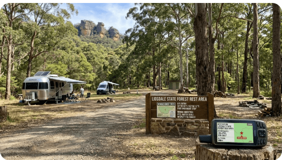
Lidsdale State Forest Rest Area
Senior Grey Nomad Guide 2026 — GPS coordinates, road conditions, Castlereagh Highway access, fuel stops, facilities, wildlife and everything you need for a safe stop on the road between Lithgow and Mudgee.
📅 Last reviewed: June 2026 | Lidsdale, NSW 2790 | Rest Area — No Camping in State Forest
Lidsdale State Forest Rest Area is a roadside rest stop located on the Castlereagh Highway, near the small locality of Lidsdale, approximately 10–12 kilometres north-west of Lithgow in the Central Tablelands region of New South Wales. Managed as a rest point for travellers on the Castlereagh Highway route between Lithgow and Mudgee, the stop sits at the edge of Lidsdale State Forest, a pine and native forest area managed by Forestry Corporation NSW. Camping is not permitted inside Lidsdale State Forest. The rest area provides a short-stop facility for travellers, heavy vehicles, caravanners and grey nomads who need a break on this regional highway. Lithgow is the nearest town for fuel, food, water and services.
📋 Table of Contents
- Why Grey Nomads Stop at Lidsdale State Forest Rest Area
- Camping Rules — What You Must Know
- Quick Facts and Key Details 2026
- How to Get There + GPS
- Road Conditions, Flooding and Unsealed Sections
- Heat, Cold and Safety — Seniors on the Tablelands
- Wildlife — Birds, Reptiles and What to Watch For
- What Other Websites Don’t Tell You
- Best Time to Visit — Month-by-Month
- Free and Low-Cost Camping Alternatives Nearby
- Dump Points Near Lidsdale
- Free Water Sources Near Lidsdale
- Fuel Stops Along the Castlereagh Highway
- Caravan Parks — Paid Alternatives
- Full Facilities Comparison Table
- Rates — All Options Near Lidsdale 2026
- Senior Safety Checklist
- What to Do Near Lidsdale — Senior Activity Guide
- Vanlife Savings Spots — GPS Coordinates and Postcodes
- Phone Signal and Emergency Communications
- Campfires and Cooking Restrictions
- Pets at the Rest Area
- Accessibility for Seniors with Mobility Limitations
- Permits, Etiquette and Waste Management
- Emergency Scenarios — What to Do
- Packing List for the Castlereagh Highway
- 5 Rest Areas Near Lidsdale on the Castlereagh Highway
- Reviews — What Grey Nomads Say
- Frequently Asked Questions
- Quick-Reference Card
- Disclaimer
Why Grey Nomads Stop at Lidsdale State Forest Rest Area
Travelling the Castlereagh Highway between Lithgow and Mudgee is one of central-western NSW’s more scenic drives, winding through state forests, farmland and the foothills of the ranges. For grey nomads heading north from Lithgow — or south from Mudgee — the Lidsdale State Forest rest area is a natural pause point, sitting roughly 10–12 kilometres out of Lithgow township.
The appeal of this rest area is straightforward: it breaks up a long drive, it’s off the highway with enough space for caravans and motorhomes to pull in safely, and it sits among quiet bushland surroundings rather than a dusty roadside. By late afternoon on weekdays, you’ll often find a small number of caravans or campervans pulled up, drivers stretching legs or making a cup of tea before pushing on to Mudgee or back to Lithgow.
The forest setting is calming. A short stop here on a clear morning, with the smell of eucalyptus and the sound of native birds, makes it one of the more pleasant brief stops on this stretch of highway. It is not a campground — but as a rest and recovery stop, it serves grey nomads well.
Camping Rules — What You Must Know
This section is critical for any grey nomad planning to stop here. Camping is not permitted within Lidsdale State Forest. This is confirmed by Forestry Corporation NSW, which manages the forest.
The rest area on the Castlereagh Highway near Lidsdale is intended as a short-stop facility — a place to rest, stretch, take a break from driving and use basic facilities if available. It is NOT a designated campground. Overnight sleeping in vehicles, setting up camp, or using the area as a free camp is not authorised at this location within the forest.
Short Stop vs Overnight — Know the Difference
| Use Type | Permitted? | Notes |
|---|---|---|
| Daytime rest break | ✅ Yes | Designated as a rest stop for highway travellers |
| Meal break / lunch stop | ✅ Yes | Pull in, rest, continue |
| Overnight camping | ❌ No | Camping not permitted — Forestry Corp NSW |
| Campfires | ❌ No | Not permitted in or near the state forest rest area |
| Pets on leash | ✅ Likely | Short stops — keep on leash, clean up after pets |
Quick Facts and Key Details 2026
| Detail | Information |
|---|---|
| Location Name | Lidsdale State Forest Rest Area |
| Highway | Castlereagh Highway |
| Nearest Town | Lithgow, NSW (~10–12 km south-east) |
| Postcode | 2790 |
| Region | Central Tablelands, NSW |
| Managed By | Forestry Corporation NSW (forest); NSW Roads (highway rest area) |
| Camping Permitted | ❌ No — not in Lidsdale State Forest |
| Cost | Free rest stop (day use only) |
| Road Surface to Entry | Sealed — Castlereagh Highway |
| Vehicle Access | Cars, caravans, motorhomes (highway pull-in) |
| Toilets | Verify on arrival — basic facilities may be present |
| Water | Not reliably available — carry your own |
| Phone Signal | Variable — Telstra generally better in this area |
| Nearest Fuel | Lithgow (~10–12 km); Portland (~20 km north) |
| GPS Coordinates (Approximate) | -33.375°S, 150.045°E — verify via Google Maps before travel |
How to Get There + GPS
Getting to the Lidsdale State Forest Rest Area is straightforward for any vehicle travelling the Castlereagh Highway. The highway is sealed its entire length through this stretch, and the rest area is a pull-in directly off the road.
📍 GPS Navigation — Lidsdale State Forest Rest Area
Approx. -33.375°S, 150.045°E
⚠️ These coordinates are approximate. Always verify via Google Maps before travel.
Postcode: 2790 | Highway: Castlereagh Highway | Nearest Town: Lithgow NSW
Travelling North from Lithgow (toward Mudgee)
From Lithgow town centre, head north-west on the Castlereagh Highway. The drive takes approximately 10–15 minutes. The rest area is located on the left-hand (western) side of the highway as you travel north, near the locality of Lidsdale and at the edge of the state forest. Look for the rest area signage as you approach — the highway is relatively straight in this section, giving good visibility ahead.
Travelling South from Mudgee (toward Lithgow)
From Mudgee, the Castlereagh Highway heading south-east will bring you through Rylstone and then toward Lithgow. As you approach Lithgow, watch for Lidsdale rest area signage on the right-hand side of the highway. Portland (approximately 20 km north of Lidsdale on the Castlereagh Highway) is a useful fuel and rest point if heading south.
Vehicle Access and Turning Space
The Castlereagh Highway rest area access at Lidsdale is a sealed pull-in suitable for caravans and motorhomes of standard Australian touring size. Large rigs should approach at reduced speed and check the pull-in dimensions on arrival, as rest areas along regional NSW highways can vary in depth. The surrounding highway is sealed, so access in wet weather is generally reliable — the concern for seniors is the forest roads and tracks off the main highway, not the rest area itself.
From Sydney (Indirect)
From Sydney, the most direct route is via the Great Western Highway to Lithgow (approximately 140 km west of Sydney CBD), then north on the Castlereagh Highway approximately 10–12 km to Lidsdale. Total driving time from Sydney is approximately 1 hour 45 minutes to 2 hours depending on traffic through the Blue Mountains.
From Mudgee
From Mudgee, the Castlereagh Highway south-east to Lidsdale is approximately 115–120 km, taking roughly 1 hour 30 minutes to 2 hours. Portland is the main fuel stop midway at approximately 95 km south of Mudgee.
Road Conditions, Flooding and Unsealed Sections
Castlereagh Highway — Main Road (Sealed)
The Castlereagh Highway through Lidsdale is sealed bitumen. Road conditions are generally reliable year-round. The highway is maintained by Transport for NSW, and current road condition updates are available at Live Traffic NSW.
Forest Roads Inside Lidsdale State Forest
Lidsdale State Forest contains internal unsealed forest roads and tracks managed by Forestry Corporation NSW. These roads are a completely different matter from the highway.
Key Road Condition Rules for Forest Tracks
- 4WD only on unsealed forest roads — dry conditions only
- No caravans — clearance and surface conditions make them unsuitable
- No 2WD campervans or motorhomes on forest roads
- Watch for fallen trees and wash-outs on forest tracks after storms
- Mobile phone coverage is limited and can be non-existent deep in the forest
- Gates: Leave as found — open stays open, closed stays closed, locked means no access
Does the Area Flood?
The Castlereagh Highway at Lidsdale does not typically flood in normal rainfall events. However, the unsealed forest roads and low-lying tracks within the state forest can become inaccessible or impassable after significant rainfall. The Lithgow region can receive periods of heavy rain, particularly in autumn and spring. Always check Bureau of Meteorology forecasts and Live Traffic NSW before travelling in uncertain weather conditions.
Heat, Cold and Safety — Seniors on the Tablelands
The Lithgow area and the Central Tablelands sit at altitude — Lithgow itself is at approximately 1,000 metres above sea level. This means temperature extremes are a genuine concern for senior grey nomads, particularly those travelling without air conditioning or with older van setups.
Cold Nights — Even in Summer
Nights at altitude can be surprisingly cold even in November and March. If you are stopping at any rest area in this region, ensure you have adequate insulation, sleeping gear and clothing. Do not underestimate the temperature drop after sunset.
Hot Days in Summer
Summer days in January and February can push above 35°C in the Lithgow region. Shade at the Lidsdale rest area depends on tree canopy — check on arrival. Carry at least 3 litres of water per person per day minimum in summer months, more if you are continuing on into western NSW.
Tell Someone Your Plans
If you are planning to explore any forest roads or tracks beyond the highway rest area, tell a responsible person your plans and expected return time. Mobile coverage in the forest can be limited or absent. If something goes wrong, having a contact who can alert police saves critical time.
Wildlife — Birds, Reptiles and What to Watch For
Lidsdale State Forest supports a mix of pine plantation and native eucalypt forest, which creates habitat for a range of native species. A short stop at the rest area in the morning is often rewarded with birdlife activity.
Birds Commonly Observed in the Area
- Eastern Rosellas — colourful parrots often feeding on grass edges
- Crimson Rosellas — deeper red colouring, common in eucalypt forest
- Grey Shrike-thrush — melodic song, often heard before seen
- Australian Magpies — frequent visitors to rest areas
- Wedge-tailed Eagles — may be seen soaring overhead on thermals
- Sulphur-crested Cockatoos — often noisy in the surrounding trees
Reptiles and Other Wildlife
- Eastern brown snake — present in the region; do not approach, give distance
- Blue-tongue lizards — may be seen basking near road edges in warmer months
- Wombats — more active at dusk and dawn; watch for them on roadsides
- Kangaroos and wallabies — dawn and dusk roadside risk on the Castlereagh Highway
What Other Websites Don’t Tell You
Most listing websites give you a name, a pin on a map and a sentence or two. Here is what experienced grey nomads have noted about this area that standard guides miss:
- Camping is not permitted here — but many websites list it incorrectly. Forestry Corporation NSW is clear. Do not be misled by generic camping apps that list state forests as free camp zones without verifying individual forest rules.
- The highway rest area and the forest are two different things. The pullout on the Castlereagh Highway is a rest area maintained for highway travellers. The state forest itself is managed separately by Forestry Corporation NSW.
- Forest roads look inviting but are not suitable for caravans. The narrow pine roads inside Lidsdale State Forest are used by timber operations and are not maintained for tourist vehicle access. Caravans should stay on the Castlereagh Highway.
- Phone signal drops off heading north. Once you leave Lithgow heading toward Portland and beyond, Telstra coverage becomes patchy. Optus and Vodafone drop off earlier. If you rely on phone connectivity, arrange your communications from Lithgow before heading north.
- The rest area is often quieter mid-week. If you want a peaceful daytime break, mid-week mornings are ideal. School holiday periods see more traffic on the Castlereagh Highway.
Best Time to Visit — Month-by-Month
| Month | Conditions | Suitability for Seniors |
|---|---|---|
| January | Hot days, cool nights at altitude. Fire danger possible. | Manageable — avoid midday heat |
| February | Similar to January. Late summer storms possible. | Caution — carry extra water |
| March | Cooling down. Autumn begins. Pleasant days. | ✅ Good — comfortable temperatures |
| April | Mild and dry. Autumn colour in the ranges. | ✅ Excellent — ideal travel month |
| May | Cool days, cold nights. Fog possible in mornings. | ✅ Good — pack warm clothing |
| June | Cold. Frost possible overnight at Lithgow altitude. | Caution — very cold nights |
| July | Coldest month. Frost regular. Snow possible on nearby ranges. | ⚠️ Cold — suitable for well-equipped vans only |
| August | Still cold but days beginning to lengthen. | Caution — morning frost |
| September | Warming. Spring wildflowers begin. Busy school holiday period. | ✅ Good — popular period |
| October | Warm, pleasant. Fire danger begins to build. | ✅ Excellent — one of the best months |
| November | Warming. Fire danger increases. Storm season begins. | Good — monitor fire conditions |
| December | Summer. School holidays — busier traffic. Hot days. | Manageable — plan around midday heat |
Free and Low-Cost Camping Alternatives Nearby
Since camping is not permitted in Lidsdale State Forest, here are verified nearby alternatives for grey nomads needing an overnight stop in this region.
📍 Nearby Lithgow Region Camps and Rest Areas
All of the following are within the broader Lithgow area and are covered in the RetireToVanLife Lithgow hub. Always verify current rules on arrival as land access and camping rules can change.
- Lake Wallace (Wallerawang) — free camping, Lithgow NSW
- Lockyers Track Campground — bush camping, Lithgow NSW
- Londonderry Reserve — free camp, Lithgow NSW
- Sunny Corner Recreation Reserve — forest camping, Lithgow NSW
- Capertee Rest Area — roadside stop, Lithgow NSW
- Marrangaroo Tunnel Hill Rest Area — highway stop, Lithgow NSW
- Meadow Glen Rest Area — quiet stop, Lithgow NSW
- Pearsons Lookout Rest Area — scenic stop, Lithgow NSW
- Ben Bullen Rest Area — free stop, Lithgow NSW
- Portland Town Common — free camping, Lithgow NSW
- Blackfellows Hand Rest Area — historic site, Lithgow NSW
Dump Points Near Lidsdale
There is no dump point at the Lidsdale State Forest Rest Area. The nearest verified dump point options for grey nomads are in Lithgow, approximately 10–12 km south-east.
| Location | Distance from Lidsdale | Notes |
|---|---|---|
| Lithgow (various) | ~10–12 km south-east | Check Campermate for current dump point locations in Lithgow |
| Portland | ~20 km north via Castlereagh Hwy | Small town — verify availability via Campermate before relying on it |
| Mudgee | ~120 km north | Mudgee has caravan parks with dump facilities |
Free Water Sources Near Lidsdale
There is no guaranteed potable water source at the Lidsdale State Forest Rest Area. Do not assume rest area facilities include drinking water. Always carry your own water when travelling this section of the Castlereagh Highway.
Water Sources — Nearest Options
- Lithgow town taps — town water, approximately 10–12 km south-east
- Portland — small town, approximately 20 km north — petrol stations may have water
- Mudgee — reliable town water, approximately 120 km north
Fuel Stops Along the Castlereagh Highway
Fuel planning is important on the Castlereagh Highway. This is a regional road through farming and forest country — do not assume fuel is available frequently. Always fuel up in Lithgow before heading north if your tank is below half.
| Town | Direction from Lidsdale | Approximate Distance | Notes |
|---|---|---|---|
| Lithgow | South-East (toward Sydney) | ~10–12 km | Multiple fuel options. Largest town. Recommended refuel point. |
| Portland | North (toward Mudgee) | ~20 km | Small town — fuel available. Verify hours before relying on it. |
| Rylstone | North (toward Mudgee) | ~80–85 km | Small town on the Castlereagh Hwy — fuel available |
| Mudgee | North | ~120 km | Full services — major regional town |
Caravan Parks — Paid Alternatives Near Lidsdale
If you need a powered site, amenities block, camp kitchen or dump point, the following paid options are your nearest alternatives to Lidsdale.
Lithgow Tourist Caravan Park
Lithgow is the closest town with caravan park facilities. As of 2026, Lithgow has caravan park accommodation available. For current rates and availability, contact the park directly or search via the Expedia widget below. Prices in regional NSW caravan parks generally range from approximately $30–$55 per night for powered sites, depending on the park and season.
Mudgee Region Caravan Parks
Mudgee, approximately 120 km north, has a well-established tourism industry and several caravan parks with full facilities. If you are planning a longer stay in the Central Tablelands wine region, Mudgee is worth considering as a base.
Free campsites and powered sites fill fast during school holidays and peak season. If your preferred site is already gone, search accommodation options in Lithgow or Mudgee below.
Accommodation search powered by Expedia. Booking through this link supports this website at no extra cost to you.
Full Facilities Comparison Table
| Facility | Lidsdale Rest Area | Lithgow Town | Portland Town | Mudgee |
|---|---|---|---|---|
| Toilets | Verify on arrival | ✅ Yes | ✅ Yes | ✅ Yes |
| Potable Water | ❌ Not reliable | ✅ Yes | ✅ Yes | ✅ Yes |
| Dump Point | ❌ No | ✅ Yes (check Campermate) | Verify | ✅ Yes |
| Fuel | ❌ No | ✅ Multiple stations | ✅ Yes | ✅ Yes |
| Powered Sites | ❌ No | ✅ Caravan parks | Limited | ✅ Yes |
| Overnight Camping | ❌ Not Permitted | ✅ Caravan parks | ✅ Options available | ✅ Yes |
| Supermarket | ❌ No | ✅ Yes | Limited stores | ✅ Yes |
| Hospital / Medical | ❌ No | ✅ Lithgow Hospital | ❌ No | ✅ Yes |
| Phone Signal | Variable (Telstra best) | ✅ Good | Limited | ✅ Good |
| WiFi | ❌ No | ✅ Library / cafes | Limited | ✅ Yes |
Rates — All Options Near Lidsdale 2026
| Option | Cost (2026 Approx.) | Notes |
|---|---|---|
| Lidsdale Rest Area (daytime stop) | Free | Rest stop only — no overnight camping |
| Lake Wallace / Portland Town Common | Free | Verify current rules — see Lithgow hub guide |
| Lithgow Caravan Park (unpowered) | ~$25–$35/night | Verify directly with park — rates subject to change |
| Lithgow Caravan Park (powered) | ~$35–$55/night | Verify directly with park |
| Mudgee Caravan Parks | ~$40–$65/night | Peak wine festival periods can be higher |
Senior Safety Checklist — On and Off the Road
Use this checklist before departing for or from the Lidsdale rest area. This is not a printable document — it is designed for reading and mentally confirming before you travel.
- Tank fuelled in Lithgow (do not leave on less than half tank)
- Water supply checked — minimum 10 litres stored
- Medications accessible and stored correctly (not in extreme heat/cold)
- Someone knows your planned route and expected arrival time
- Live Traffic NSW checked for road conditions before departure
- BOM weather forecast reviewed for the travel day
- Phone charged — emergency numbers saved (000 and local hospital)
- Fire danger rating checked if travelling in summer/spring/autumn
- Dump point completed in Lithgow if tank is near capacity
- First aid kit accessible (not buried at the back of the van)
- Tyre pressure checked — altitude and temperature change tyre pressure
- Rest area verified as rest stop only — no overnight camping at Lidsdale
- Overnight option confirmed if not continuing to Mudgee same day
- UHF CB radio on if travelling any forest tracks (channel 40)
- EpiPen or personal medical needs confirmed accessible
What to Do Near Lidsdale — Senior Activity Guide
While the Lidsdale rest area itself is a transit stop, the broader region offers a range of activities suited to senior grey nomads.
Lithgow (10–12 km south-east)
- Lithgow State Mine Heritage Park and Railway — excellent heritage attraction, flat access, café on site
- Blast Furnace Park — historic iron-making site, walking paths, picnic areas
- Lithgow Visitor Information Centre — maps, local guides, touring advice
- Eskbank House Museum — local history museum in Lithgow
- Supermarkets, chemists and hardware stores — practical stop for stocking up
Capertee Valley (approx. 50 km north)
- One of the world’s widest valleys — spectacular scenery
- Birding destination of international significance — superb parrot habitat
- Glen Davis and surrounds — historic oil shale town, ghost town exploration
Mudgee Wine Region (approx. 120 km north)
- Over 40 cellar doors within the Mudgee region
- Seniors-friendly wine tasting experiences
- Weekly markets and arts precinct in Mudgee town centre
- Gulgong — nearby heritage town, home of the Henry Lawson Centre
🗺️ Vanlife Savings Spots — GPS Coordinates and Postcodes
Save every free camp, rest area and overnight stop as you travel. Use the interactive Vanlife Savings Spots map below to find nearby stops, get directions and log your favourites for the Castlereagh Highway and Lithgow region.
COPY PROMPT ➔ ASK AI ➔ SAVE TO FORM ➔ ADD SPOT PIN ➔ GET DIRECTIONS
📍 Interactive map — find free camps, rest areas and overnight stops. Enable location for best results.
| Location | Postcode | Approx. GPS | Notes |
|---|---|---|---|
| Lidsdale State Forest Rest Area | 2790 | -33.375°S, 150.045°E (approx.) | Rest stop only — no camping. Verify on arrival. |
| Portland Town Common | 2847 | Verify via Google Maps | Free camping — check current rules |
| Lake Wallace, Wallerawang | 2845 | Verify via Google Maps | Free camping — lakeside |
| Capertee Rest Area | 2846 | Verify via Google Maps | Roadside stop |
| Ben Bullen Rest Area | 2790 | Verify via Google Maps | Free stop — Castlereagh Hwy |
Phone Signal and Emergency Communications
Mobile phone coverage at Lidsdale and along the Castlereagh Highway heading north from Lithgow is variable. Lithgow itself has good coverage on all major networks. As you move north past Lidsdale and toward Portland, Telstra maintains the most reliable signal. Optus and Vodafone/TPG coverage drops off progressively heading into more rural areas.
Coverage Summary — Castlereagh Highway North of Lithgow
| Network | Lithgow | Lidsdale Area | Portland | Rylstone Area |
|---|---|---|---|---|
| Telstra | ✅ Good | Variable | Variable | Patchy |
| Optus | ✅ Good | Limited | Limited | Poor |
| Vodafone/TPG | ✅ Good | Limited | Very limited | Poor |
EPIRB / PLB Recommendation for Seniors
A registered Personal Locator Beacon (PLB) or satellite communicator (such as a Garmin inReach) provides emergency communication and GPS tracking independent of mobile networks. For grey nomads travelling regional NSW highways and forest areas, this is a strongly recommended piece of safety equipment.
Campfires and Cooking Restrictions
Campfires at Lidsdale Rest Area
Campfires are not permitted at the Lidsdale State Forest Rest Area. The rest area is a highway pull-in — not a designated campsite — and open fires are not appropriate or permitted in this setting.
Total Fire Ban Periods
The Lithgow region is subject to Total Fire Ban days during the fire season (typically October through March, but variable). On Total Fire Ban days, no outdoor fires are permitted anywhere in the region, and even solid fuel camping stoves (using wood or charcoal) may be prohibited. Gas stoves are generally exempt from Total Fire Bans but always confirm with the NSW Rural Fire Service.
Food and Supplies Near Lidsdale
- Lithgow (~10–12 km) — full supermarkets (Woolworths, Coles), bakeries, cafés, takeaway
- Portland (~20 km north) — small general stores and local shops
- Mudgee (~120 km north) — full range of supermarkets, restaurants, delis
Pets at the Rest Area
The Lidsdale State Forest Rest Area is a highway rest stop — not a national park or nature reserve — so there are no specific rules preventing dogs on leash at the rest area itself. However, grey nomads should observe the following:
- Keep dogs on leash at all times at the rest area
- Clean up after pets — always carry waste bags
- Do not allow pets to chase wildlife
- Do not take pets into state forest areas where wildlife is present and they may disturb native animals
- In hot weather, ensure pets have shade and water — vehicle interiors heat rapidly
Accessibility for Seniors with Mobility Limitations
The Lidsdale State Forest Rest Area is a highway rest stop accessed from a sealed road. The rest area surface is generally flat and accessible for seniors with moderate mobility. However, specific accessibility features such as accessible toilet facilities, handrails and accessible parking bays have not been independently confirmed for this location and should be verified on arrival.
Practical Accessibility Notes
- Road surface to the rest area: sealed — suitable for wheelchairs if approaching from the highway
- Rest area internal surface: verify on arrival — gravel or sealed depending on maintenance
- Accessible toilets: not confirmed — if this is a requirement, use facilities in Lithgow before heading north
- Lithgow has accessible public toilets at the Visitor Information Centre and Civic Centre
Permits, Etiquette and Waste Management
Permits
No permit is required to stop at the Lidsdale State Forest Rest Area as a highway rest stop. If you wish to enter Lidsdale State Forest on forest roads, note that Forestry Corporation NSW manages access and some areas may require permits or be restricted during active forestry operations. Check with Forestry Corporation NSW before entering forest roads.
Rest Area Etiquette
- Do not monopolise the rest area — if the area is busy, allow others to use facilities and move on when rested
- Keep noise to a minimum, particularly in early morning or evening
- Take all rubbish with you — there may be no rubbish bins at the rest area
- Do not dump grey water, black water or waste on the ground at rest areas
- Respect other travellers — give space between vehicles
Waste Management
Do not dispose of any grey or black water at the Lidsdale rest area. Use designated dump points in Lithgow or Portland. Carry a rubbish bag for all waste until a proper bin is available. Leave the rest area in better condition than you found it.
Emergency Scenarios — What to Do
Vehicle Breakdown at Lidsdale Rest Area
- Pull fully off the highway into the rest area if possible
- Activate hazard lights immediately
- Place warning triangles or reflectors if you have them
- Call your roadside assistance provider (NRMA, RAA, etc.)
- If no signal — drive or walk toward Lithgow (south-east) to get coverage
- Emergency: call 000
Medical Emergency
- Call 000 immediately
- Nearest hospital: Lithgow Hospital, Great Western Highway, Lithgow — approximately 10–12 km south-east
- Give your location as: Castlereagh Highway, Lidsdale, approximately 10–12 km north-west of Lithgow
- If mobile signal is poor, drive toward Lithgow for better coverage
Stuck in Forest Road
Packing List for the Castlereagh Highway
- Minimum 15 litres stored water per day of travel in remote sections
- 3 days of non-perishable food supply as emergency reserve
- Full first aid kit — accessible, not buried
- Personal medications — sufficient supply for the journey plus 3 days extra
- Warm clothing and sleeping gear — Tablelands nights are cold year-round
- Sun protection — hat, SPF 50+ sunscreen, sunglasses
- Torch and spare batteries or USB rechargeable headlamp
- UHF CB radio (channel 40 on highway, channel 18 in some forestry areas)
- Personal Locator Beacon (PLB) — registered with AMSA
- Paper map of the region — do not rely solely on phone GPS
- Recovery gear if travelling any forest tracks (recovery boards, snatch strap)
- Jump starter pack (lithium battery type)
- Spare tyre and tyre repair kit
- Bull bar or roo deflectors for dawn/dusk driving
- Dump point hose and fittings
- Grey water holding tank — do not dump at rest areas
5 Rest Areas Near Lidsdale on the Castlereagh Highway
| Rest Area | Distance from Lidsdale | Direction | Notes |
|---|---|---|---|
| Ben Bullen Rest Area | ~30 km north | North (toward Mudgee) | Castlereagh Hwy — free stop |
| Capertee Rest Area | ~50 km north | North (toward Capertee Valley) | Roadside stop — scenic area |
| Marrangaroo Tunnel Hill Rest Area | ~8 km south-east | South-East (toward Sydney) | Near Lithgow — highway stop |
| Meadow Glen Rest Area | Lithgow region | Verify via Lithgow hub | Quiet stop — Lithgow area |
| Pearsons Lookout Rest Area | Lithgow region | Verify via Lithgow hub | Scenic lookout stop |
Reviews — What Grey Nomads Say
“Pulled in here for a 30-minute break heading up to Mudgee. Quiet, peaceful, good tree cover. The birds were lovely — we had a pair of rosellas just a few metres away. Wouldn’t try to camp here though — it’s clearly just a rest stop. Straight back on the highway after a stretch and a cuppa.”
— Margaret & Ken, travelling north in a 19ft caravan, April 2025 ★★★★☆
“Nice enough spot for a quick break. The highway access is easy with the caravan — just watch your speed coming off the highway. We noticed the road into the forest looked tempting but we’d read online that it’s not suitable for caravans. Stayed on the sealed area. Lithgow is a good town for services before heading up to the Capertee.”
— Dave, solo motorhome traveller, September 2025 ★★★★☆
“We stopped here as the last break before pushing into Mudgee. It’s basic — just a pull-off really — but it does the job. The view into the forest is lovely on a clear day. We did see a wedge-tailed eagle circling overhead. Not a place to linger too long, but exactly what you need between Lithgow and Mudgee.”
— Ros & Brian, Grey Nomads, October 2025 ★★★☆☆
Frequently Asked Questions
Can I camp overnight at Lidsdale State Forest Rest Area?
No. Camping is not permitted within Lidsdale State Forest, as confirmed by Forestry Corporation NSW. The rest area is a highway rest stop for short breaks only. See our list of nearby alternatives for overnight stays.
Is the Castlereagh Highway sealed through Lidsdale?
Yes. The Castlereagh Highway through Lidsdale is sealed bitumen. The unsealed roads are the forest tracks inside the state forest, which are not suitable for caravans or 2WD motorhomes.
Is there fuel at Lidsdale?
No. The nearest fuel is in Lithgow (approximately 10–12 km south-east) or Portland (approximately 20 km north). Fuel up in Lithgow before heading north on the Castlereagh Highway.
What is the nearest hospital to Lidsdale?
Lithgow Hospital on the Great Western Highway in Lithgow, approximately 10–12 km south-east of Lidsdale. In an emergency, call 000.
Can I take my caravan on the forest roads in Lidsdale State Forest?
No. The forest roads inside Lidsdale State Forest are not suitable for caravans, 2WD campervans or motorhomes. Clearance issues and surface conditions (slippery when wet) make these roads hazardous for towing vehicles. 4WD only, dry conditions only, for those who choose to use forest tracks.
Is there phone signal at Lidsdale?
Mobile coverage is variable. Telstra generally provides the most reliable signal in this area. Optus and Vodafone/TPG coverage is more limited. Always make important calls and check data while still in Lithgow before heading north.
How far is Lidsdale from Mudgee?
Lidsdale is approximately 110–120 km south of Mudgee via the Castlereagh Highway. Driving time is approximately 1 hour 30 minutes to 2 hours depending on conditions and stops.
What are the best nearby overnight camps for grey nomads?
Portland Town Common (approximately 20 km north) and Lake Wallace at Wallerawang (near Lithgow) are nearby free camping options. See the full Lithgow region rest area guide at RetireToVanLife.com.
📋 Quick-Reference Card — Lidsdale State Forest Rest Area 2026
| Location | Castlereagh Highway, Lidsdale NSW 2790 |
| GPS (Approx.) | -33.375°S, 150.045°E — verify via Google Maps |
| Nearest Town | Lithgow ~10–12 km south-east |
| Camping | ❌ NOT PERMITTED — rest stop only |
| Cost | Free (daytime rest stop) |
| Road to Rest Area | Sealed — Castlereagh Highway |
| Forest Roads | Unsealed — 4WD dry conditions only, no caravans |
| Nearest Fuel South | Lithgow ~10–12 km |
| Nearest Fuel North | Portland ~20 km |
| Dump Point | Lithgow (check Campermate) |
| Water | Not available — carry your own |
| Phone Signal | Variable — Telstra best |
| Emergency | 000 | Lithgow Hospital ~10–12 km |
| Road Conditions | livetraffic.com |
| Weather | bom.gov.au |
| Fuel Prices | petrolspy.com.au |
| Dump Points | campermate.com.au |
Protect Your Van While You Rest: Get 5% OFF all StarterStopper immobiliser products with promo code: RTV5
As an affiliate, I earn from qualifying purchases at no extra cost to you.
RV LIFE Trip Wizard — USA RV Trip Planning Tool
RV LIFE Trip Wizard is a USA-based RV trip planning platform. If you are a US visitor reading this guide, RV LIFE may be useful for planning your stateside adventures. Australian grey nomads should use Australian tools such as Campermate and WikiCamps for local trip planning.

As an affiliate, I earn from qualifying purchases at no extra cost to you.
© 2026 RetireToVanLife.com — All rights reserved. Written for Senior Grey Nomads. Safe travels. 🚐