Free Camping Near Port Lincoln SA — Grey Nomad Guide 2026
The seafood capital of Australia sits at the southern tip of Eyre Peninsula, 650 km from Adelaide. Here is everything a grey nomad needs to know before rolling in — overnight options, road conditions, fuel gaps, hospital contacts, accessibility and what the brochures never tell you.
Last reviewed: June 2026. Road conditions, fuel prices and campsite rules change — always verify before you travel.
📋 Table of Contents
- Location, Address and GPS
- Can You Stay Overnight — Rules and Self-Containment
- Free and Low-Cost Overnight Options
- Facilities Table
- Road Access, Fuel Distances and Flood Risk
- Boston Bay Foreshore — Flat Walks and Pelicans
- Seafood — What Seniors Can Access Easily
- Coffin Bay Day Trip — 45 km West
- Mikkira Station — Koala Sanctuary
- Lincoln National Park — Track Conditions and Rig Suitability
- Best Time of Year — Honest Seasonal Guide
- Medical and Emergency Contacts
- Mobile Coverage by Carrier
- Natural Circuit — Internal Links
- GPS Coordinates and Postcodes Table
- FAQ — 8 Questions Answered
- Quick Verdict
- Planning Tip Box
1. Location, Address and GPS
Port Lincoln sits at the southern tip of the Eyre Peninsula in South Australia, on the western shore of Boston Bay — one of the largest natural harbours in the world by surface area. The town is approximately 650 km from Adelaide by road via Port Augusta and the Lincoln Highway, and roughly 250 km south of Whyalla. There is no ferry or barge service connecting Port Lincoln to the rest of South Australia — road is the only way in and the only way out.
Despite its relative isolation, Port Lincoln functions as a self-contained regional city with a full hospital, supermarkets, fuel stations, mechanics and a substantial marina. It is the commercial fishing capital of Australia and earns its title of seafood capital through the sheer volume of southern bluefin tuna, King George whiting, garfish, oysters and abalone that leave its wharves each year.
For grey nomads, Port Lincoln is not a place you stumble through on the way to somewhere else. It sits at the end of a peninsula with no road continuing south. You come here deliberately, and that is precisely what makes it worth the drive.
📍 Port Lincoln Town Centre GPS Reference
-34.7278, 135.8660
Port Lincoln, SA 5629
Nearest cross streets: Liverpool Street and Tasman Terrace (town centre)
⚠ GPS note: Coordinates are within 50 metres of the stated location and are provided as navigation guidance only. Always confirm on arrival against current signage.
📍 Kirton Point Caravan Park Area GPS Reference
-34.7195, 135.8723
Kirton Point, Port Lincoln SA 5629
⚠ GPS note: Coordinates are within 50 metres of the stated location and are provided as navigation guidance only. Always confirm on arrival against current signage.
2. Can You Stay Overnight — Rules and Self-Containment
This is the question that matters most and the one most travel guides sidestep with vague language. Here is the honest picture as of June 2026.
Port Lincoln is managed by the City of Port Lincoln council. Like most South Australian councils, Port Lincoln does not operate a blanket free camping policy across its foreshore or reserve land. Casual overnight parking in vehicles on public streets or foreshore carparks is generally not permitted without explicit signage allowing it. Council rangers do patrol popular areas, particularly around the marina foreshore and Kirton Point.
Self-containment is increasingly expected — and practically necessary — at any informal stop near Port Lincoln. If you do not have a self-contained rig with a cassette or composting toilet and grey water containment, your options reduce significantly. South Australia does not have a formal national self-containment certification scheme equivalent to some other states, but demonstrating you have an onboard toilet and are not discharging grey water onto public land is the practical standard councils and rangers apply.
For grey nomads who want genuine peace of mind and a legal overnight stay in or very close to Port Lincoln, the following options are the most realistic as of June 2026.
3. Free and Low-Cost Overnight Options Near Port Lincoln
Kirton Point Caravan Park Area
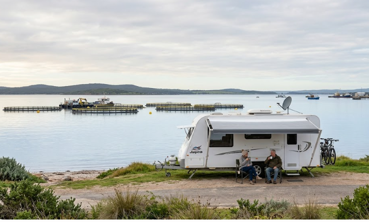
Kirton Point Caravan Park is a council-operated facility on the northern foreshore of Port Lincoln, well-positioned for easy walking access to Boston Bay and the town centre. It is not a free camping area — powered and unpowered sites are available at low nightly rates that are reasonable by regional SA standards. For grey nomads who want a legal, flat, foreshore site with access to dump points and amenities, this is the most straightforward choice in Port Lincoln itself. The foreshore location is genuinely flat, the views across Boston Bay are wide, and the proximity to town means you can leave the rig parked and walk or take a short drive to everything.
The park caters to caravans and motorhomes of varying lengths, though very large rigs or combinations over approximately 25 metres in total should confirm site availability before arrival. At the time of writing, this facility remains operational — contact City of Port Lincoln directly for current rates and availability as these change seasonally.
Marina Foreshore Area
The Port Lincoln Marina is a working marina as well as a leisure precinct with restaurants, the Visitor Information Centre and public amenities. There is foreshore parking in the area, and some grey nomads have historically used the marina carpark for short stays, but this is not a designated free camping area and overnight vehicle stays are not formally permitted. It is best treated as a day use area — an excellent one — rather than an overnight stop.
Ragged Island Foreshore Area
Ragged Island is located in Boston Bay, visible from the Port Lincoln foreshore. There is no vehicle access to Ragged Island itself. The term “Ragged Island foreshore” sometimes appears in nomad conversation to describe sections of foreshore road near the southern end of the bay. As of June 2026, there is no formally gazetted free camping area at this location. Some self-contained travellers have overnighted in the area without incident, but this is not a council-sanctioned arrangement. If you choose to stop here, ensure you are fully self-contained, leave no trace and confirm there is no signage prohibiting overnight stays before settling in.
Rest Areas on the Lincoln Highway North of Town
For travellers who arrive late or want a no-cost option before entering town, several designated rest areas exist on the Lincoln Highway approaching Port Lincoln from the north. These are managed by the Department for Infrastructure and Transport SA and are intended for short rest breaks. Extended overnight stays are technically subject to the same rest area rules that apply across SA — generally one night without a formal extension arrangement. Always check current signage. For more information on rest areas across SA, see our guide to rest areas South Australia.
Coffin Bay Camping (45 km West — Low Cost)
While not Port Lincoln itself, Coffin Bay National Park and the Coffin Bay township (45 km west) offer low-cost camping options that are a genuine alternative base for exploring the region. This is covered in detail in the Coffin Bay section below.
4. Facilities Table — Port Lincoln Overnight Options
| Facility | Kirton Point CP | Marina Foreshore | Ragged Island Foreshore | Lincoln Hwy Rest Areas |
|---|---|---|---|---|
| Flush Toilets | ✅ Yes | ✅ Public toilets nearby | ❌ No | ✅ At most stops |
| Dump Point | ✅ Yes (on site) | ❌ No | ❌ No | ❌ No |
| Potable Water | ✅ Yes | ✅ Public taps nearby | ❌ No | ⚠ Some — check signage |
| Showers | ✅ Yes | ❌ No | ❌ No | ❌ No |
| Powered Sites | ✅ Yes | ❌ No | ❌ No | ❌ No |
| Shade | ⚠ Partial | ⚠ Limited | ⚠ Minimal | ⚠ Varies |
| Bins | ✅ Yes | ✅ Yes | ❌ No | ✅ Most stops |
| Camp Fires | ❌ Not permitted | ❌ Not permitted | ❌ Not permitted | ❌ Not permitted |
| Generators | ⚠ Time restricted — check on arrival | ❌ Not appropriate | ❌ Not appropriate | ⚠ Check signage |
| Overnight Permitted | ✅ Yes (paid) | ❌ Not formally | ⚠ Unconfirmed — check signage | ⚠ Short stays — check signage |
| Rig Size | Most rigs — confirm large combos | Day use only | Accessible for most rigs | Most rigs — check each bay |
| Self-Containment Required | Recommended | Essential if staying | Essential | Recommended |
Facilities and availability are accurate to June 2026 to the best of our knowledge. Always confirm on arrival. Campsite rules and dump point access can change without notice.
5. Road Access, Fuel Distances and Flood Risk
Is the Road to Port Lincoln Sealed?
Yes. The Lincoln Highway — the main road connecting Port Lincoln to the rest of Eyre Peninsula — is sealed for its entire length from Port Augusta in the north to Port Lincoln in the south. This is a significant point for grey nomads towing caravans: you do not need a 4WD or high-clearance vehicle to reach Port Lincoln. The road is suitable for all standard caravans, motorhomes and camper trailers.
The route from Adelaide runs north via the Augusta Highway to Port Augusta, then south along the Lincoln Highway through Whyalla, Cowell, Arno Bay, Port Neill, Tumby Bay and finally into Port Lincoln. The full Adelaide to Port Lincoln distance is approximately 650 km and typically takes seven to eight hours with stops, depending on your rig and driving pace. This is a full day’s drive — do not attempt it in one push if you are managing fatigue, blood pressure or other health considerations. Plan an overnight stop at Port Augusta or Whyalla on the way through. See our guide to free camping near Port Augusta SA for options at that midpoint.
Does the Road Flood?
The Lincoln Highway is generally a reliable year-round road and does not have the flooding vulnerability of roads in the state’s far north or along the Oodnadatta Track. However, low-lying sections between Port Neill and Tumby Bay and around the Arno Bay area can experience water over the road after significant rainfall events. June is mid-winter in South Australia and rain is possible on Eyre Peninsula. In 2026 the Eyre Peninsula has not seen the same catastrophic flooding events that have affected other SA regions, but it is always worth checking the Department for Infrastructure and Transport SA road conditions website or calling 1300 361 033 before travelling after heavy rain.
Fuel — North, South, East and West of Port Lincoln
| Direction | Next Fuel Stop | Approximate Distance | Fuel Types Available | Notes |
|---|---|---|---|---|
| North (Lincoln Hwy) | Tumby Bay | ~48 km | ULP, Diesel | Small town — confirm hours before relying on it |
| North (continuing) | Port Neill | ~80 km | ULP, Diesel | Very small — top up at Tumby Bay instead |
| North (major stop) | Cowell | ~140 km | ULP, Diesel | More reliable, larger service station |
| West (Flinders Hwy to Coffin Bay) | Coffin Bay township | ~45 km | ULP, Diesel | Confirm LPG availability — not guaranteed |
| West (continuing to Ceduna) | Cummins then Wudinna | ~100–200 km | ULP, Diesel | Plan carefully on this route — gaps are real |
| South | No road south — Port Lincoln is the terminus | N/A | N/A | Lincoln National Park tracks are not through-routes |
| In Port Lincoln | Multiple service stations in town | Within 2 km of centre | ULP, Diesel, LPG (selected outlets) | Diesel widely available. LPG — confirm at United or Ampol outlets in town before relying on it |
LPG Availability
LPG (autogas) is available at selected service stations in Port Lincoln as of June 2026. This is one of the better-supplied regional towns on Eyre Peninsula for LPG availability, but supply can occasionally be interrupted. If your motorhome or caravan relies on LPG for cooking or heating, fill up in Port Lincoln before heading to Coffin Bay or anywhere along the national park tracks — do not assume smaller communities will have it. Our broader guide to free camping South Australia covers fuel planning strategies for the whole state.
Diesel
Diesel is readily available at multiple outlets in Port Lincoln. This is not a concern in the town itself. The concern is between towns on Eyre Peninsula — particularly heading west toward Ceduna, where gaps between reliable fuel stops can exceed 150 km on some route choices. If you are heading from Port Lincoln toward Ceduna, see our guide to free camping near Ceduna SA for fuel and stop planning along that corridor.
6. Boston Bay Foreshore — Flat Walks, Pelicans and Fishing Boats
Boston Bay is one of the defining features of Port Lincoln for grey nomads, and the foreshore walk along its western shore is one of the most pleasant low-effort activities in regional South Australia. The foreshore path connecting the marina area north toward Kirton Point is flat, paved for most of its length and suitable for people with mobility limitations, walking frames and those using wheelchairs. There are no significant gradients.
In June, the light on Boston Bay is extraordinary — low winter sun on still mornings creates mirror reflections across a harbour that dwarfs Sydney Harbour in surface area. Pelicans are a daily fixture along the foreshore, particularly near the boat ramp areas where local fishers clean their catch. You do not need to book anything, carry anything or walk far to enjoy this — a fold-out chair, a thermos of tea and twenty minutes watching pelicans work the fish cleaning tables is genuinely one of the better free experiences on Eyre Peninsula.
The working fishing fleet is visible from the foreshore. Port Lincoln’s fishing industry is serious — the tuna farming operations in Boston Bay involve large sea cages visible offshore, and the coming and going of fishing vessels gives the bay a purposeful energy that distinguishes it from purely tourist-driven coastal towns.
Accessibility Notes for the Boston Bay Foreshore
- The main foreshore path from the marina to Kirton Point is predominantly flat and paved
- Public toilets are accessible at the marina precinct
- Seating and picnic areas are spaced along the foreshore
- The boat ramp carpark has level parking close to the water’s edge
- There are no significant steps or kerbs on the main foreshore route
- Companion card holders should confirm specific attraction access at the Visitor Information Centre
For those interested in fishing, Boston Bay and the surrounding waters offer King George whiting, garfish and squid. A recreational fishing licence is required in South Australia — purchase online through the PIRSA (Primary Industries and Regions SA) website or at local tackle shops. Jetty fishing from the public jetties requires no boat and is entirely accessible for people with limited mobility.
7. Seafood — Tuna Farms, Fresh Fish Co-op and What Seniors Can Access Easily
Port Lincoln’s identity is built almost entirely around seafood, and it delivers on that reputation in ways that are directly accessible to retired travellers without requiring boat trips, steep stairs or advance bookings in most cases.
Fresh Fish at the Co-op
The Port Lincoln Seafood Co-op and associated fish retailers sell local product directly from the wharf area and from shops in the town centre. In June, King George whiting is in excellent condition, garfish is plentiful and southern bluefin tuna is available both fresh and smoked. Prices reflect that you are as close to the source as you can possibly be in SA. Buying direct is significantly cheaper than purchasing equivalent product in Adelaide. Many grey nomads buy whole fish, fillet it at the caravan park amenities, vacuum seal portions and freeze them for the road — an entirely practical approach if your rig has a freezer.
Tuna Farms — Viewing from Shore
The southern bluefin tuna farming operations in Boston Bay are visible from various points along the foreshore and from the higher vantage points around town. There is no formal tuna farm tour that lands visitors on the sea cages — this is a working industrial aquaculture operation. However, the scale of the operation is impressive from shore, and understanding what you are looking at adds context to why Port Lincoln exists as it does economically. The Visitor Information Centre can provide current information on any boat-based tour operators running at the time of your visit.
Oysters
Coffin Bay oysters are the dominant premium oyster brand associated with this region, and while they are grown 45 km west in Coffin Bay, they are readily available in Port Lincoln’s restaurants and at the fish retailers. If you can eat a dozen oysters at a table overlooking Boston Bay in June, do it. The combination of fresh cold-water product and a quiet mid-winter foreshore setting is hard to match anywhere in South Australia.
Senior-Friendly Dining
Several restaurants and cafes in the Port Lincoln CBD and marina area offer senior meal sizes or are explicitly senior-friendly in their service approach. The marina precinct has accessible parking and level access dining options. June is off-peak and you will not need to wait for tables at most venues — a marked contrast to the chaos of school holiday periods.
8. Coffin Bay Day Trip — 45 km West, Oysters, National Park and Low-Cost Camping
Getting There
Coffin Bay is 45 km west of Port Lincoln along the Flinders Highway. The road is sealed for the entire distance. There are no significant flood risks on this route in normal conditions, though after heavy winter rain it is worth confirming there are no localised issues. The drive takes approximately 35 to 40 minutes and is suitable for caravans, motorhomes and all vehicle types. There is no steep terrain or challenging geometry on this route.
Coffin Bay Township
Coffin Bay township is a small, quiet coastal community that has become famous almost entirely for its oysters. The local oyster farms produce what many consider the finest oysters in Australia — grown slowly in the cold, clean waters of Coffin Bay and harvested at a size that is generous without being overwhelming. In June, the township is quiet, the oyster shacks and restaurants are operating without the summer crowd pressure, and a dozen freshly shucked oysters at a table looking out across the bay is a thoroughly achievable afternoon.
The Coffin Bay Hotel and several local eateries serve fresh oysters. Some operators offer oyster farm experiences — check with the Coffin Bay Visitor Centre for current tour availability in June 2026, as seasonal schedules vary and some smaller operators reduce frequency in winter months.
Coffin Bay National Park
Coffin Bay National Park surrounds the township and encompasses a significant area of coastal heath, sand dunes, beaches and estuary. Entry requires a National Parks pass, which can be purchased online or at the park entry point. The park contains some excellent beaches and birdwatching areas.
Critical rig warning for grey nomads: Many tracks within Coffin Bay National Park are 4WD only and are not suitable for caravans, large motorhomes or any vehicle without high clearance. The sandy tracks to Almonta Beach, Black Springs and other interior locations will beach a rear-wheel-drive motorhome or a caravan without question. Do not take your rig onto these tracks based on optimism. The sealed road to the main beach area near the township is accessible for most rigs, but anything beyond that requires a 4WD without your van attached.
Camping at Coffin Bay National Park
The national park offers low-cost camping at designated sites — these are not free but are among the more affordable paid camping options on Eyre Peninsula. Booking is through the SA National Parks booking system (Parks SA). Some sites are accessible for caravans; others are not. Check the Parks SA website for current availability and site specifications before you drive in expecting to set up. June availability is generally good — this is a quieter period and you are unlikely to encounter the booking pressure of school holidays.
9. Mikkira Station — Koala Sanctuary and Gravel Road Access
Mikkira Station is a private property approximately 20 km north-west of Port Lincoln that operates as a koala and wildlife sanctuary. It is one of the few places in South Australia where you can walk among koalas in a natural bush setting rather than viewing them through enclosure fencing.
The Road to Mikkira
Access to Mikkira Station involves a section of gravel road. This is the most important practical consideration for grey nomads. The gravel approach road is generally well-maintained and manageable for most caravans and motorhomes in dry conditions. It is not a corrugated outback track — it is a rural property access road. However, after rain the surface can become slippery and muddy, and June is a month where rain is possible on Eyre Peninsula.
Our recommendation: In dry conditions in June, most standard caravans and motorhomes can manage the Mikkira access road without difficulty. Drive slowly, keep to the formed track and do not attempt it if there has been significant recent rainfall. If you are towing a large twin-axle caravan or driving a bus-sized motorhome, consider detaching the van at a suitable point on the sealed road and driving in with the tow vehicle alone. This protects your rig and is the sensible approach when you are unsure of a gravel surface.
What to Expect at Mikkira
Mikkira Station is a working property with a natural koala population in the blue gum trees. The koalas are wild — they are not fed or handled — but they are habituated to visitors and the property’s setup allows close observation. In June the koalas are active during daylight hours as winter temperatures are cooler and they are less lethargic than during summer heat.
There is an entry fee to Mikkira Station. Contact the station directly for current pricing and opening hours before visiting, as these can vary. The property also has basic camping available — check current availability and facilities directly with the owners, as this has changed over the years.
Accessibility at Mikkira
The property involves walking on natural bush terrain. Paths are not paved. People with significant mobility limitations may find the terrain challenging, but the koalas are often visible in trees very close to the property’s accessible areas, which means you do not need to walk far to have a worthwhile experience. Take walking aids, wear closed shoes and move at your own pace.
10. Lincoln National Park — Track Conditions, Rig Suitability and Day Trip Options
Lincoln National Park occupies the southern tip of the Eyre Peninsula, directly south of Port Lincoln. It is one of the most significant coastal national parks in South Australia, encompassing dramatic coastal cliffs, sheltered beaches, heath and mallee scrub, abundant birdlife and the remote Cape Catastrophe — named by Matthew Flinders after eight of his crew drowned there in 1802.
What Most Travel Guides Miss About Lincoln National Park
The park is frequently promoted in tourist material with images of pristine beaches and dramatic cape scenery. What tourist material often omits is that accessing the best parts of this park — particularly the coastline and beaches south of the main park entry — requires a 4WD vehicle in good condition and, for much of the park, the complete absence of a caravan or large trailer. The sandy tracks and rocky coastal approaches that make the park spectacular are the same features that make them inappropriate for large rigs.
This is not a park you can drive a 22-foot van into and expect to reach the coastal highlights. This is honest, not discouraging — the park is genuinely worth visiting, but with the right vehicle configuration.
What Is Accessible for Large Rigs and Standard Vehicles
The sealed road into the park leads to Donnington, which serves as the main day-visitor area. There is a boat ramp, picnic facilities and views across Memory Cove from accessible vantage points nearby. The area around Stamford Hill offers elevated views and is accessible via a short walk from a vehicle parking area on a gravel but manageable surface. This is realistic territory for motorhomes and visitors without a 4WD.
The camping within Lincoln National Park at September Beach and other designated sites involves tracks that are not suitable for large caravans. If you want to camp inside the park, this typically requires a 4WD, a smaller camper trailer or a self-contained vehicle that can manage rough ground. The national park booking system (Parks SA) describes site access requirements — read these carefully before booking.
Cape Catastrophe
Cape Catastrophe is at the very southern tip of the Eyre Peninsula. Access requires a 4WD track from within the national park. This is not an accessible location for caravans, large motorhomes or standard 2WD vehicles. The views from the coastal walking trail near the cape are extraordinary, but the physical demands of the walking trail also mean it is not suitable for people with significant mobility limitations. If you want to see the cape, the best realistic approach for a grey nomad without a 4WD is to research guided tour operators from Port Lincoln — at the time of writing, some local operators offer day trips into the park — but confirm availability for June 2026 with the Port Lincoln Visitor Information Centre.
National Parks Pass
A South Australian National Parks pass is required to enter Lincoln National Park. Passes are available online through Parks SA or at the park entry point. An annual pass is cost-effective if you plan to visit multiple national parks during your Eyre Peninsula itinerary.
11. Best Time of Year — Honest Seasonal Guide for Grey Nomads
June — Why It Is an Excellent Time to Visit
June is genuinely one of the better months for a grey nomad visit to Port Lincoln. Here is the honest picture:
- No school holidays: School holiday periods — particularly Christmas and Easter — bring large volumes of family campers, higher accommodation prices, booking pressure at all facilities and significantly more competition for any informal camping spots. June avoids all of this.
- Mild temperatures: Port Lincoln’s Mediterranean-influenced climate means June daytime temperatures are typically in the 14–18°C range. It is cool but not cold. Nights drop to around 8–10°C, which is comfortable in a well-insulated van with adequate heating. CPAP users will find the cooler temperatures more conducive to comfortable machine operation.
- Whale watching: Southern right whales and occasionally humpback whales use the waters around Eyre Peninsula during winter migration. While Port Lincoln is not the primary whale watching hub of the peninsula, sightings from headlands and the foreshore are possible in June and July. The calmer winter seas help.
- Wildflowers: Late winter and early spring (August to October) bring the iconic Eyre Peninsula wildflower season, with everlastings and native orchids across the heathlands. June is slightly early for peak flowering, but the ground cover is green and the landscape is at its most lush after winter rain.
- Seafood quality: King George whiting and garfish are in excellent condition in winter cold water. The fish co-op and local retailers are operating at full supply. Oysters from Coffin Bay are at their best in the cooler months.
- Quiet campsites: Kirton Point Caravan Park and the Coffin Bay national park sites are significantly less crowded in June. You are more likely to get a good site position, quieter nights and more time and space around amenities.
What to Avoid
Christmas and January school holidays: Port Lincoln becomes significantly busier in December and January. Caravan parks fill weeks in advance, informal sites attract crowds and the character of the town shifts toward a tourist-heavy atmosphere. Unless you have specific bookings and genuinely enjoy the energy of peak season, this period is the one to avoid as a grey nomad.
Long weekend rushes: Port Lincoln is close enough to Adelaide (in South Australian terms — seven hours is manageable for a long weekend trip) that public holiday long weekends attract day-trippers and campers from the city. June long weekends can see a brief bump in visitor numbers. The Queen’s Birthday long weekend in June may see some increase in foreshore and marina traffic.
Extreme summer heat: January and February can bring hot northerly wind events to Port Lincoln with temperatures occasionally exceeding 40°C. Caravans and motorhomes in exposed foreshore positions without powered sites for air conditioning become uncomfortable quickly. The grey nomad wisdom of following the cool — south in summer, north in winter — applies here. June is the right time of year on the climate calendar for Eyre Peninsula.
12. Medical and Emergency Contacts
| Service | Name / Location | Phone Number | Notes |
|---|---|---|---|
| Hospital | Port Lincoln Hospital, 51 St Andrews Terrace, Port Lincoln SA 5629 | 08 8683 2200 | Full hospital — emergency department, inpatient services. Last hospital before national park. |
| Emergency | Police / Fire / Ambulance | 000 | Available across SA. Mobile coverage required — see mobile section. |
| Police — Port Lincoln | Port Lincoln Police Station | 08 8688 3444 | Non-emergency contact. Confirm current number at time of travel. |
| SES (State Emergency Service) | SA SES — for storm, flood or accident | 132 500 | 24/7 — not for life-threatening emergencies (use 000) |
| Road Conditions | Department for Infrastructure and Transport SA | 1300 361 033 | Confirm road status after rain events |
| Parks SA Ranger — Lincoln NP | Lincoln National Park Ranger | Contact via Parks SA 08 8688 3111 | Track conditions, camping queries. Confirm number before travel. |
| Nearest alternate hospital — North | Whyalla Hospital, Whyalla SA | 08 8648 8400 | Approximately 250 km north of Port Lincoln via Lincoln Hwy. Confirm number at time of travel. |
| Port Lincoln Visitor Information Centre | Tasman Terrace, Port Lincoln | 08 8683 3544 | Local knowledge, current tour operators, maps. Confirm hours before visiting. |
13. Mobile Coverage by Carrier — Port Lincoln and Surrounds
In Port Lincoln Town
Telstra: Good to very good coverage throughout Port Lincoln township, the marina area, Kirton Point and the main shopping and hospital precinct. Telstra is the clear choice for grey nomads who need reliable connectivity in and around Port Lincoln.
Optus: Coverage exists in the Port Lincoln township but is patchy in some areas and significantly weaker than Telstra. Optus users should not assume full-service availability across all parts of town. Confirm coverage on the Optus coverage map before travel.
Vodafone / TPG: Coverage in Port Lincoln is limited. Vodafone’s network has significant gaps on Eyre Peninsula beyond major towns. Do not rely on Vodafone for reliable data or voice calls outside the Port Lincoln CBD.
On the Lincoln Highway North of Port Lincoln
Telstra coverage extends reasonably well along the Lincoln Highway between Port Lincoln and Tumby Bay and continuing north toward Cowell. There are gaps in coverage between smaller communities. Optus and Vodafone coverage on this route is significantly less reliable.
At Coffin Bay
Telstra provides the most reliable coverage at Coffin Bay township. Coverage within Coffin Bay National Park — particularly on the sandy tracks inland from the township — becomes unreliable and should not be counted on for emergency calls. If you are travelling into the national park on 4WD tracks, have a satellite communicator (such as a Garmin inReach or SPOT device) as your emergency backup. This is not optional advice — it is a genuine safety consideration in this location.
At Lincoln National Park
Mobile coverage within Lincoln National Park is unreliable, particularly south of the main day-visitor area. Telstra has the best reach of any carrier but there are significant black spots throughout the park, especially on coastal and southern tracks. Do not rely on any mobile carrier for emergency communication once you are on unsealed tracks south of the park entry. A satellite communicator or personal locator beacon (PLB) is strongly recommended for anyone venturing beyond Donnington. For broader safety planning as a grey nomad, our guide on grey nomad safety tips covers communication redundancy in detail.
At Mikkira Station
Coverage at Mikkira Station is limited. Telstra provides the best chance of a signal, but this is rural terrain and coverage is not guaranteed. Have a PLB on you when walking the property.
14. The Eyre Peninsula Grey Nomad Circuit — Where Port Lincoln Fits
Port Lincoln is not an island — it sits within a broader Eyre Peninsula circuit that offers grey nomads weeks of content if the full loop is driven. Understanding where Port Lincoln sits in that circuit helps with route planning and fuel management.
The most common approach for grey nomads travelling the Eyre Peninsula is to enter from the north at Port Augusta, drive south along the Lincoln Highway to Port Lincoln, then return north and either exit via the same route or continue west across the peninsula toward Ceduna.
If you are beginning your Eyre Peninsula journey and need overnight options at the northern entry point, see our guide to free camping near Port Augusta SA — this covers the stop before you head south.
Heading north from Port Lincoln, free camping near Whyalla is approximately 250 km up the Lincoln Highway and provides a practical midpoint stop on the return journey to Adelaide.
If you are planning to exit the Eyre Peninsula heading west toward the Nullarbor, our guide to free camping near Ceduna SA covers the stop at the far western end of the peninsula — approximately 470 km from Port Lincoln via Wudinna and Kimba.
For grey nomads doing the full loop around Australia or planning multi-month South Australian routes, our guide on the best routes to drive around Australia and our free camping South Australia 2026 overview are the logical companion reads to this article.
Travellers coming from the east who need rest area guidance before reaching Port Augusta should check our Melbourne to South Australia rest areas guide for the pre-SA portion of the journey.
Finally, for a comprehensive state-wide picture of designated rest areas within South Australia itself, our guide to rest areas South Australia provides the full coverage map context.
15. GPS Coordinates and Postcodes — Key Locations Near Port Lincoln
| Location | GPS Coordinates | Postcode | Notes |
|---|---|---|---|
| Port Lincoln Town Centre | -34.7278, 135.8660 | 5629 | Liverpool St / Tasman Tce reference point |
| Kirton Point Caravan Park Area | -34.7195, 135.8723 | 5629 | Northern foreshore — confirm park entry point on arrival |
| Port Lincoln Marina | -34.7265, 135.8695 | 5629 | Day use — visitor centre and restaurants nearby |
| Port Lincoln Hospital | -34.7300, 135.8620 | 5629 | 51 St Andrews Terrace — 08 8683 2200 |
| Lincoln National Park Entry (Donnington area) | -34.8012, 135.8723 | 5606 | Approximate entry area — confirm with Parks SA before travel |
| Coffin Bay Township | -34.6148, 135.4747 | 5607 | 45 km west via Flinders Highway — sealed road |
| Mikkira Station (approximate) | -34.6550, 135.7450 | 5629 | Approximate — gravel road access, confirm with property before visiting |
| Tumby Bay (fuel north) | -34.3760, 136.1017 | 5605 | ~48 km north — ULP and diesel |
⚠ GPS note: All coordinates are within 50 metres of the stated location and are provided as navigation guidance only. Always confirm on arrival against current signage. Coordinates for national park entry points and private properties are approximate — confirm exact access with the relevant authority before travel.
16. FAQ — 8 Questions Answered for Grey Nomads Visiting Port Lincoln
Q1. Is there genuinely free camping in Port Lincoln, or do you have to pay?
Honest answer: truly free, formally designated, council-sanctioned camping within the Port Lincoln township is limited as of June 2026. Kirton Point Caravan Park is the most practical overnight option in town and charges a nightly site fee — reasonable for regional SA but not free. Some self-contained travellers use sections of foreshore or carparks for informal overnight stops, but these are not officially designated free camping areas. If free camping is your priority, the most realistic strategy is to base yourself in Coffin Bay National Park on a low-cost site and day trip into Port Lincoln, or to use designated rest areas on the Lincoln Highway north of town for a single night before moving into the paid park. For broader free camping options across the state, our free camping South Australia 2026 guide provides the full picture.
Q2. Can I take my 25-foot caravan into Lincoln National Park?
In most areas of Lincoln National Park — no. The main day visitor area at Donnington is reachable on a gravel road that most caravan combinations can manage with care in dry conditions, but the national park’s coastal tracks, beach access points and camping sites further into the park are on sandy or rough 4WD-only tracks that are not suitable for large caravans. The camping sites within the park that do exist have access requirements — check the Parks SA website and read the site specifications carefully. If you have a large twin-axle van, the park’s interior camping is not for you. Leave the van at Kirton Point or Coffin Bay and drive in with your tow vehicle alone if you want to explore the park’s 4WD tracks.
Q3. What is the fuel situation if I run low on the way to Port Lincoln?
The Lincoln Highway is a sealed road with fuel available at Tumby Bay (approximately 48 km north of Port Lincoln), Cowell (approximately 140 km north) and other communities along the route. In practice, if you leave Port Augusta with a full tank, you will have more than enough range to reach Port Lincoln without a mid-journey fuel stop, even with a large rig. The more important fuel consideration is planning for day trips from Port Lincoln — particularly if heading into Lincoln National Park or driving west to Coffin Bay and beyond. Always leave Port Lincoln with a full tank before any exploration. Diesel is readily available in Port Lincoln itself. For LPG, confirm which outlets are currently supplying autogas before you need it.
Q4. Is the Flinders Highway to Coffin Bay suitable for a large motorhome?
Yes. The Flinders Highway between Port Lincoln and Coffin Bay (45 km) is sealed, in reasonable condition and entirely suitable for motorhomes, caravans and all vehicle types. There are no significant grades or challenging corners. The drive is straightforward and takes under 40 minutes at a comfortable pace. The issue is not the highway — it is what happens when you turn off the sealed road inside Coffin Bay National Park. Stay on the sealed road and the foreshore access near the township, and you will have no difficulty. Turn onto the sandy national park tracks and a large rig will become stuck.
Q5. What medical facilities are available if something goes wrong?
Port Lincoln Hospital at 51 St Andrews Terrace (phone 08 8683 2200) is a full regional hospital with an emergency department. It is the most significant medical facility on the southern Eyre Peninsula and it is the last hospital before you head into Lincoln National Park or any remote coastal area south and west of town. The next hospital to the north is Whyalla at approximately 250 km. Carry a list of your medications, your GP’s contact details and your Medicare card. If you use a CPAP machine, ensure your power supply is adequate for nights off the grid. If you are diabetic and managing insulin, be aware that remote areas south of Port Lincoln have no medical support — plan accordingly.
Q6. Will I get phone reception in Lincoln National Park or at Coffin Bay?
In Coffin Bay township, Telstra provides usable coverage. Within Coffin Bay National Park on the sandy interior tracks, coverage is unreliable and should not be assumed. In Lincoln National Park beyond the main day visitor area, coverage drops significantly for all carriers, with Telstra being the most reliable but still not dependable on the southern tracks toward Cape Catastrophe. If you are heading into remote park areas — even for a day trip — carry a personal locator beacon (PLB) or a satellite communicator. This is a genuine safety requirement, not an optional extra. PLBs are registered free of charge in Australia and the signal reaches rescue coordination centres regardless of mobile coverage. Do not go into these parks without one if you are travelling solo.
Q7. Is June a good time to visit Port Lincoln as a grey nomad, and what will the weather be like?
June is a very good time to visit Port Lincoln for grey nomads. Daytime temperatures are typically mild — around 14 to 18 degrees Celsius — and nights are cool but manageable in a well-heated van, dropping to around 8 to 10 degrees. There is no extreme heat to contend with, no school holiday crowds and no booking pressure at caravan parks. Rain is possible in June — this is Eyre Peninsula’s wetter season by its Mediterranean climate pattern — but it is rarely prolonged. The landscape is green and the seafood is in excellent condition. The one practical effect of June rain is that gravel roads to places like Mikkira Station can become slippery and should be avoided in wet conditions. Allow for flexibility in your plan if a weather event moves through.
Q8. What do most travel guides miss about Port Lincoln that a grey nomad actually needs to know?
Several things. First, the town is larger and more functional than many grey nomads expect — it has supermarkets, a Bunnings, mechanics, a full hospital and all the services of a regional city. You do not need to over-prepare for a siege before arriving. Second, the Lincoln National Park is significantly less accessible to standard caravans and 2WD vehicles than its prominent place in tourist marketing suggests. Do not plan the park as the highlight of your visit unless you have a 4WD and can leave the van behind. Third, the tuna farming industry means Boston Bay has industrial infrastructure — sea cages, workboats, feed barges — that is visible from the foreshore. This is not unattractive, but it is different from the pristine natural harbour some visitors picture from brochure photographs. Fourth, Coffin Bay is a genuinely better base for budget camping in the area than Port Lincoln itself — the national park sites are bookable, low-cost and the oysters are on your doorstep. Fifth: the foreshore walk between the marina and Kirton Point on a calm June morning, with the bay still and the pelicans working the fish cleaning tables, is worth the 650-kilometre drive from Adelaide on its own.
17. Quick Verdict
Port Lincoln earns its place on every serious grey nomad’s Eyre Peninsula itinerary. It is a functional, well-serviced regional city with a hospital, reliable fuel, good Telstra coverage in town and a foreshore that delivers genuine daily pleasure without requiring a booking, a ticket or significant physical effort. The seafood alone — King George whiting, oysters from Coffin Bay 45 minutes away, smoked tuna from the co-op — justifies the detour south from the Lincoln Highway.
The honest caveats: free camping directly in Port Lincoln is limited and the best options require either paying for a site at Kirton Point or planning an informal self-contained stop on the foreshore with appropriate expectations. Lincoln National Park is spectacular but largely inaccessible to large rigs — go in with your tow vehicle only or on a guided tour. Mikkira Station’s gravel road is manageable in dry conditions but skip it after rain. And do not leave Port Lincoln toward the park or Coffin Bay on less than a full tank.
For grey nomads in June 2026, the combination of quiet conditions, quality seafood, accessible foreshore walking, the Coffin Bay day trip and the proximity of a full hospital makes Port Lincoln one of the most rounded and rewarding destination stops in South Australia’s regional network. Recommended.
18. Planning Tip — Where Port Lincoln Fits in Your SA Journey
Port Lincoln sits at the end of a peninsula — your planning needs to account for the drive south and the drive back north before any westward or northward continuation. Use these guides to build your full itinerary:
- State-wide free camping overview: free camping South Australia
- Northern entry point to Eyre Peninsula: free camping near Port Augusta SA
- Midpoint heading north from Port Lincoln: free camping near Whyalla
- Western exit from Eyre Peninsula: free camping near Ceduna SA
- SA rest areas for the full route: rest areas South Australia
- Safety planning for remote travel: grey nomad safety tips
- Full Australia circuit route planning: best routes to drive around Australia
- Pre-SA rest area planning (coming from the east): Melbourne to South Australia rest areas
- Budget planning across SA: vanlife savings spots
COPY PROMPT ➔ ASK AI ➔ SAVE TO FORM ➔ ADD SPOT PIN ➔ GET DIRECTIONS
📍 Interactive map — find free camps, rest areas and overnight stops. Enable location for best results.

As an affiliate, I earn from qualifying purchases at no extra cost to you.
Exclusive Offer: Get 5% OFF all StarterStopper immobiliser products with promo code: RTV5
Visit StarterStopper.com to see our data-backed security solutions
As an affiliate, I earn from qualifying purchases at no extra cost to you.