Tenterfield to Warialda Rest Areas (Northern Tablelands NSW) – Free Camping & Stopover Senior Nomads Guide 2026
The Tenterfield to Warialda rest areas corridor through the Northern Tablelands of NSW is one of the most underrated free-camping routes in eastern Australia for senior grey nomads in 2026. Stretching roughly 180 km through granite country, open farmland, and cool-climate timber belt, this route offers a genuine chain of safe, low-cost overnight stops suitable for caravans, motorhomes, and campervans of all sizes. This guide gives you every GPS coordinate, toilet status, dump point location, overnight rule, and senior-specific safety note for every rest area from Tenterfield south-west to Warialda — so you can plan confidently before you leave Wi-Fi behind.
Table of Contents
- Why Senior Grey Nomads Drive the Tenterfield to Warialda Route
- What Google Doesn’t Tell You About These Rest Areas
- Permits, Fees and Overnight Rules — 2026
- Legume Rest Area
- Warialda Rest Area
- Cunninghams Rest Area
- Tigers Gap Rest Area (Westbound)
- Marr Creek Rest Area
- Sleepy Hollow Rest Area
- Sleepy Hollow Rest Area (Southbound)
- Sinclair Lookout Rest Area
- Nancy Coulton Lookout Rest Area
- Ti Tree Creek Rest Area
- Van Life Savings Spots App — AI Prompt + Interactive Map
- Dump Points and Free Water — Full Table
- Senior Checklist — Tenterfield to Warialda Route 2026
- GPS Master Table — Every Stop on This Route
- Frequently Asked Questions — Tenterfield to Warialda Rest Areas
1. Why Senior Grey Nomads Drive the Tenterfield to Warialda Route in 2026
The Tenterfield to Warialda rest areas route runs primarily along the Bruxner Highway and connecting roads through the New England and Northern Tablelands region of northern NSW. It is not a tourist highway in the conventional sense — there are no surf breaks or major theme parks — but for senior caravanners this is precisely its advantage. Traffic is light, roads are well-maintained, overtaking lanes are spaced regularly, and the rest areas are specifically designed for heavy vehicles to pull off safely.
For grey nomads travelling between Queensland and Victoria via the inland route, this corridor saves time compared to the coastal highway and delivers genuine rest-area variety: lookout stops, creek-side pullouts, purpose-built highway rest bays, and the full-service town of Warialda at the southern end. For 2026 travellers, the combination of free overnight capability, cool highland air, and consistent mobile Telstra coverage on most of this route makes it a standout inland option.
For more route planning ideas for senior travellers, see our full guide to grey nomad routes around Australia — including the best inland corridors for avoiding peak coastal traffic.
2. What Google Doesn’t Tell You About These Tenterfield to Warialda Rest Areas
Most search results for rest areas on this route give you a name and maybe a basic map pin. That is not enough information if you are driving a 30-foot van and arriving at dusk. Here is what other sites leave out:
- Overnight rules are not posted online — NSW rest areas administered by Transport for NSW (TfNSW) generally permit stays up to 20 hours under the heavy vehicle fatigue rules, but this applies to all travellers using the area for genuine rest. Signage at each site is the legal authority — rules can change without online updates.
- No dump points at any roadside rest area on this route — the nearest certified dump points are in Tenterfield township (north) and Warialda Caravan Park (south). Plan your grey water and black water management before departing.
- Water is not available at highway rest areas — carry minimum 60 litres per person for a multi-night run of this corridor.
- No power at any rest area on this route — CPAP users must have a lithium battery backup or solar solution before relying on these stops.
- Surface conditions vary seasonally — the gravel-surface areas can become slippery after rain. Check the Live Traffic NSW app before departure from Tenterfield.
3. Permits, Fees and Overnight Rules — Tenterfield to Warialda Rest Areas 2026
No permits are required and no fees apply to any of the roadside rest areas listed in this guide. They are publicly maintained TfNSW highway rest areas or local council roadside stops. The following table summarises the rules framework:
| Rule Category | What Applies | Where to Confirm |
|---|---|---|
| Permit required? | No — all sites are free public rest areas | TfNSW / local council signage on-site |
| Fee required? | No | Free — no payment station at any site |
| Maximum stay | Check on-site signage — typically 20 hrs under fatigue rules; some sites may be day-use only | Physical sign at entry |
| Self-contained required? | Strongly recommended — no toilets at some sites; no dump point anywhere on route | — |
| Fires permitted? | No open fires at any highway rest area | NSW Rural Fire Service rules apply |
| Pets | Permitted on lead — rest areas are not national parks | Local council by-laws may vary |
| Park fees to pay? | None — no national park on this corridor requires entry fee for roadside stops | NSW National Parks: nationalparks.nsw.gov.au |
4. Legume Rest Area — First Stop After Tenterfield
Legume Rest Area is located approximately 40 km south-west of Tenterfield on the Bruxner Highway, making it the logical first overnight option after fuelling up in Tenterfield town. The area sits in a quiet rural clearing set back slightly from the highway, providing a noticeably lower road-noise environment than you might expect.
| Detail | Information |
|---|---|
| Address | Bruxner Highway, Legume NSW 2476 |
| GPS | -28.5950, 152.1040 |
| Postcode | 2476 |
| Surface | Gravel/compacted dirt — suitable for caravans and motorhomes |
| Toilets | Check on-site — basic pit toilet may be available; not guaranteed |
| Water | None — fill tanks in Tenterfield before departure |
| Dump point | None on-site — nearest: Tenterfield approx. 40 km north-east |
| Power | None |
| Overnight stay | Generally permitted — confirm on-site signage |
| Nearest fuel | Tenterfield ~40 km NE or Woodenbong ~25 km NW |
| Mobile coverage | Telstra regional — variable; test on arrival |
| Pets | Permitted on lead |
| Senior verdict | ✅ Good quiet overnight stop for self-contained rigs. Prepare fully in Tenterfield before arriving. |
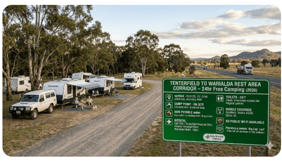
5. Warialda Rest Area — Best Service Access on the Tenterfield to Warialda Route
Warialda Rest Area is the southern anchor of this route and the most practical stop for seniors who want easy access to town services. Warialda is a genuine regional town with a supermarket, fuel, pharmacy, medical centre, and a caravan park with powered sites — giving it a level of support infrastructure that no other stop on this corridor can match.
| Detail | Information |
|---|---|
| Address | Gwydir Highway, Warialda NSW 2402 |
| GPS | -29.5424, 150.5726 |
| Postcode | 2402 |
| Toilets | Available — flush toilets nearby in town precinct |
| Dump point | Warialda Caravan Park (see Section 15 for GPS) |
| Free water | Available at Warialda Caravan Park and town taps — confirm on arrival |
| Medical | Warialda Medical Centre: 18 Hope Street, Warialda NSW 2402 — 02 6729 1466 |
| Hospital | Warialda MPS (Multi-Purpose Service): Grafton Street, Warialda NSW 2402 — 02 6792 1000 | GPS: -29.5414, 150.5712 |
| Fuel | Available in Warialda township — multiple options |
| Supermarket | IGA Warialda, Hope Street, Warialda NSW 2402 |
| Senior verdict | ✅ Best stop on the route for resupply, medical access, and dump point. Arrive here to reset before continuing south. |
6. Cunninghams Rest Area — Low-Traffic Quiet Stop Mid-Route
Cunninghams Rest Area is positioned on a quieter section of the route, making it one of the lowest-traffic overnight options on the Tenterfield to Warialda corridor. For senior grey nomads who find busy highway rest areas disruptive to sleep, this is a genuine alternative.
| Detail | Information |
|---|---|
| Address | Bruxner Highway, between Legume and Tenterfield, NSW 2476 |
| GPS | -28.6480, 152.0190 |
| Postcode | 2476 |
| Surface | Gravel — suitable for caravans |
| Toilets | Basic — check on-site |
| Water / Dump | None — self-contained only |
| Senior verdict | ✅ Quiet overnight option. Ideal for self-contained rigs. Low traffic volume is its best feature for light sleepers. |
Full detail: Cunninghams Rest Area — complete guide.
7. Tigers Gap Rest Area (Westbound) — Elevated Scenic Stop
Tigers Gap Rest Area (Westbound) offers one of the most memorable roadside settings on this entire route. Positioned at an elevated point on the New England plateau rim, it provides westbound travellers with expansive views across the plains below — a genuine payoff after navigating the winding descent from the tablelands.
| Detail | Information |
|---|---|
| Address | Bruxner Highway, Tigers Gap NSW 2370 |
| GPS | -29.1610, 151.5870 |
| Postcode | 2370 |
| Surface | Sealed / gravel mix — good for all vehicle types |
| Best use | Short break and photography — check signage before committing to overnight |
| Wind exposure | ⚠️ Elevated and exposed — can be cold and windy at night |
| Senior verdict | Best as a scenic stop and leg-stretch. Check signage for overnight eligibility. |
Full detail: Tigers Gap Rest Area Westbound — complete guide.
8. Marr Creek Rest Area — Quiet Bushland Setting
Marr Creek Rest Area offers a sheltered, natural-environment stop surrounded by native bush. It is one of the calmer options on this route — lower traffic, tree cover for shade, and a setting that rewards travellers who prefer solitude over convenience.
| Detail | Information |
|---|---|
| Address | Bruxner Highway near Marr Creek, NSW 2370 |
| GPS | -29.2250, 151.4890 |
| Postcode | 2370 |
| Tree shade | Yes — natural bush canopy provides afternoon shade |
| Water / Dump | None — fully self-contained required |
| Senior verdict | ✅ Excellent if you want a quiet, shaded, peaceful overnight away from highway noise. Bring everything you need. |
Full detail: Marr Creek Rest Area — complete guide.
9. Sleepy Hollow Rest Area — Named Perfectly for Grey Nomads
Sleepy Hollow Rest Area earns its name. It is a calm, sheltered pullout well-liked by experienced grey nomads who have done this route multiple times. The low traffic volume and tucked-away feel make it one of the better overnight choices for solo travellers and those who prioritise sleep quality.
| Detail | Information |
|---|---|
| Address | Bruxner Highway, Sleepy Hollow area NSW 2370 |
| GPS | -29.3110, 151.3590 |
| Postcode | 2370 |
| Facilities | Seating, rest area — check on-site for toilet status |
| Senior verdict | ✅ One of the better overnight spots for seniors who need quiet sleep. Low-noise environment. |
Full detail: Sleepy Hollow Rest Area — complete guide.
10. Sleepy Hollow Rest Area (Southbound) — Return-Route Option
The southbound Sleepy Hollow Rest Area serves travellers heading in the opposite direction — from Warialda back toward Tenterfield or continuing south. It mirrors the northbound site in character but is positioned on the opposite carriageway for safe access without crossing traffic.
| Detail | Information |
|---|---|
| Address | Bruxner Highway (southbound carriageway), NSW 2370 |
| GPS | -29.3125, 151.3575 |
| Postcode | 2370 |
| Senior verdict | Dependable return-route stop. Suitable for breaking up longer drive days. |
Full detail: Sleepy Hollow Rest Area Southbound — complete guide.
11. Sinclair Lookout Rest Area — Scenic Pause with a View
Sinclair Lookout Rest Area is the most visually rewarding stop on this route for photography and landscape appreciation. The elevated position gives sweeping views across the Northern Tablelands — a genuine highlight for travellers who want more than a concrete bay beside a truck route.
| Detail | Information |
|---|---|
| Address | Bruxner Highway, Sinclair Lookout, NSW 2370 |
| GPS | -29.3740, 151.2380 |
| Postcode | 2370 |
| Best use | Short break, photography, leg stretch — limited overnight space |
| Accessibility | Pathway to lookout — check surface condition before walking if mobility is limited |
| Senior verdict | Outstanding daytime stop. Use it for the view, not the overnight. |
Full detail: Sinclair Lookout Rest Area — complete guide.
12. Nancy Coulton Lookout Rest Area — Panoramic Rest Stop
Named in honour of former federal member for Parkes Nancy Coulton, this lookout rest area provides panoramic views and a safe off-highway parking space for travellers who want to take in the scale of the New England landscape before descending toward Warialda.
| Detail | Information |
|---|---|
| Address | Bruxner Highway, Nancy Coulton Lookout, NSW 2370 |
| GPS | -29.4120, 151.1640 |
| Postcode | 2370 |
| Views | Panoramic — tablelands to western plains |
| Senior verdict | Memorable daytime stop. Photography highlight of the route. Not designed for overnight use by large rigs. |
Full detail: Nancy Coulton Lookout Rest Area — complete guide.
13. Ti Tree Creek Rest Area — Practical Midpoint Stop
Ti Tree Creek Rest Area is the practical choice for travellers who simply need a safe, easy pull-off between the more scenic lookout stops and the town of Warialda. It does not compete for scenery, but it delivers on the basics: flat surface, easy entry and exit, and enough space for full-size rigs.
| Detail | Information |
|---|---|
| Address | Gwydir Highway near Ti Tree Creek, NSW 2402 |
| GPS | -29.4780, 150.8970 |
| Postcode | 2402 |
| Surface | Flat, accessible — suitable for all rig sizes |
| Senior verdict | No frills, no fuss — good midpoint stop before pushing into Warialda for resupply. |
Full detail: Ti Tree Creek Rest Area — complete guide.
14. Van Life Savings Spots App — Find Camps, Save GPS, Plan Safe
Before you leave Wi-Fi in Tenterfield or Warialda, use the Van Life Savings Spots app to save every GPS coordinate from this guide directly to your device. Once saved, they work offline — critical when Telstra coverage drops in the valleys between lookout points.
- “Find free overnight rest areas between Tenterfield and Warialda NSW with toilets suitable for caravans”
- “Where is the nearest dump point to Legume Rest Area NSW?”
- “What is the nearest hospital to Tigers Gap Rest Area on the Bruxner Highway?”
- “Find free water fill stations within 50 km of Sinclair Lookout Rest Area NSW”
- “Are there any pet-friendly free camps between Tenterfield and Warialda?”
COPY PROMPT ➔ ASK AI ➔ SAVE TO FORM ➔ ADD SPOT PIN ➔ GET DIRECTIONS
📍 Interactive map — find free camps, rest areas and overnight stops. Enable location for best results.
15. Dump Points and Free Water — Tenterfield to Warialda Route 2026
🗑️ Dump Point Table
| Location | Address | Postcode | GPS | Cost / Notes |
|---|---|---|---|---|
| 🗑️ Tenterfield Caravan Park Dump Point | 4 Manners Street, Tenterfield NSW | 2372 | -29.0537, 152.0178 | Available to park guests and day visitors — confirm cost on arrival. Use BEFORE departing north end of route. |
| 🗑️ Warialda Caravan Park Dump Point | Matthew Street, Warialda NSW | 2402 | -29.5430, 150.5715 | Available — confirm access hours with park management. Use on arrival at south end of route. |
💧 Free Water Fill Table
| Location | Address | Postcode | GPS | Notes |
|---|---|---|---|---|
| 💧 Tenterfield Council Water Tap (Railway Park) | Rouse Street, Tenterfield NSW | 2372 | -29.0580, 152.0160 | Potable water — fill tanks BEFORE departing Tenterfield. No water available at any rest area en route. |
| 💧 Warialda Town Water (Caravan Park) | Matthew Street, Warialda NSW | 2402 | -29.5430, 150.5715 | Potable water available at caravan park. Confirm with management on arrival. |
16. Senior Checklist — Tenterfield to Warialda Rest Areas Route 2026
Screenshot this table or bookmark this page. Check every row before departing Tenterfield.
| Item | Why It Matters on This Route | ✓ |
|---|---|---|
| Travel insurance with medical evacuation | Nearest major hospital is Inverell (60+ km from mid-route). RFDS coverage applies in emergencies. | ☐ |
| PLB registered with AMSA | Mobile signal can drop in valleys. A PLB is your emergency backup. Register free at beacons.amsa.gov.au | ☐ |
| Lithium battery or solar for CPAP | Zero 240V power at all rest areas on this route. No exceptions. | ☐ |
| 80+ litres of water on board | No water at any of the 10 rest areas. Fill in Tenterfield before departure. | ☐ |
| Dump point used in Tenterfield | No dump point between Tenterfield and Warialda. Next certified point: Warialda Caravan Park GPS: -29.5430, 150.5715 | ☐ |
| 2-week prescription medication supply | No pharmacy between Tenterfield and Warialda. Buy medications before leaving. | ☐ |
| Medicare card + medication list in waterproof pouch | Keep in glovebox — not packed in the van. Critical in any medical event. | ☐ |
| Offline maps downloaded | Download Tenterfield–Warialda segment on Maps.me or Google Maps before leaving town Wi-Fi. | ☐ |
| GPS saved for all 10 rest areas | Use Van Life Savings Spots to pin all locations before leaving Wi-Fi. | ☐ |
| Warialda MPS phone saved | Warialda MPS: 02 6792 1000 — save before departure | ☐ |
| Fuel topped up in Tenterfield | Limited fuel options mid-route. Top up before leaving and again in Warialda for the next leg. | ☐ |
| Dog water, lead and tie-out (if applicable) | Dogs permitted at rest areas on lead. No dog-specific facilities at any site on this route. | ☐ |
| Live Traffic NSW app open | Check livetraffic.com before departing — gravel surfaces can be affected by rain. GPS: Tenterfield to Warialda 2026 route. | ☐ |
COPY PROMPT ➔ ASK AI ➔ SAVE TO FORM ➔ ADD SPOT PIN ➔ GET DIRECTIONS
📍 Interactive map — find free camps, rest areas and overnight stops. Enable location for best results.
17. GPS Master Table — Every Stop: Tenterfield to Warialda Rest Areas 2026
Save all coordinates to your Van Life Savings Spots app before leaving Wi-Fi. These work offline.
| Stop / Facility | Full Address + Postcode | GPS (copy to app) | Notes |
|---|---|---|---|
| Tenterfield township (start) | High Street, Tenterfield NSW 2372 | -29.0508, 152.0188 | Fuel, water, dump point, supermarket, pharmacy — resupply here first |
| 💧🗑️ Tenterfield Caravan Park (dump + water) | 4 Manners Street, Tenterfield NSW 2372 | -29.0537, 152.0178 | Dump point and water — use before departing north |
| Legume Rest Area | Bruxner Highway, Legume NSW 2476 | -28.5950, 152.1040 | Overnight — self-contained; no water or dump |
| Cunninghams Rest Area | Bruxner Highway, NSW 2476 | -28.6480, 152.0190 | Quiet overnight; no water or dump |
| Tigers Gap Rest Area (Westbound) | Bruxner Highway, Tigers Gap NSW 2370 | -29.1610, 151.5870 | Elevated — wind-exposed; scenic break recommended |
| Marr Creek Rest Area | Bruxner Highway, NSW 2370 | -29.2250, 151.4890 | Shaded, quiet overnight; self-contained required |
| Sleepy Hollow Rest Area | Bruxner Highway, NSW 2370 | -29.3110, 151.3590 | Popular overnight — low noise; self-contained |
| Sleepy Hollow Rest Area (Southbound) | Bruxner Highway (southbound), NSW 2370 | -29.3125, 151.3575 | Return-route version — opposite carriageway |
| Sinclair Lookout Rest Area | Bruxner Highway, NSW 2370 | -29.3740, 151.2380 | Panoramic views — best daytime stop on route |
| Nancy Coulton Lookout Rest Area | Bruxner Highway, NSW 2370 | -29.4120, 151.1640 | Photography highlight — daytime use |
| Ti Tree Creek Rest Area | Gwydir Highway, NSW 2402 | -29.4780, 150.8970 | Flat, practical midpoint stop before Warialda |
| Warialda Rest Area (end point) | Gwydir Highway, Warialda NSW 2402 | -29.5424, 150.5726 | Town services, fuel, supermarket, medical |
| 💧🗑️ Warialda Caravan Park (dump + water) | Matthew Street, Warialda NSW 2402 | -29.5430, 150.5715 | Dump point and water — use on arrival at south end |
| 🏥 Warialda MPS (hospital/medical) | Grafton Street, Warialda NSW 2402 | -29.5414, 150.5712 | 02 6792 1000 — save before departing |
| 🏥 Inverell Hospital (nearest major hospital mid-route) | Evans Street, Inverell NSW 2360 | -29.7742, 151.1137 | 02 6721 8100 — approx. 60–80 km from mid-route stops |
Frequently Asked Questions — Tenterfield to Warialda Rest Areas for Grey Nomads 2026
Are the Tenterfield to Warialda rest areas free to stay overnight?
Yes — all rest areas on this route are free and do not require a permit or booking. They are public highway rest areas managed by Transport for NSW and local councils. Always check on-site signage for any overnight time limits, as rules can change without online notice.
Is there a dump point between Tenterfield and Warialda?
No. There is no dump point at any of the 10 rest areas on this route in 2026. The nearest certified dump points are at Tenterfield Caravan Park (GPS: -29.0537, 152.0178) at the northern end, and Warialda Caravan Park (GPS: -29.5430, 150.5715) at the southern end. Use the Tenterfield dump point before departure.
Is there any free water available on this route?
No free water is available at any rest area between Tenterfield and Warialda. Fill your water tanks to capacity in Tenterfield before departing. The next confirmed water source is Warialda Caravan Park at the south end of the route.
Do these rest areas have toilets?
Toilet availability varies. Some sites have basic pit toilets; others have none. Toilet condition and availability should be confirmed on arrival. All self-contained travellers should have on-board toilet capacity for this route. Do not rely on toilet facilities being available at any specific site.
What is the nearest hospital to the mid-point of this route?
Inverell District Hospital is the nearest major hospital to the mid-section of the Tenterfield to Warialda route. Address: Evans Street, Inverell NSW 2360. Phone: 02 6721 8100. GPS: -29.7742, 151.1137. It is approximately 60–80 km from the central rest area stops. Save this number before you leave Wi-Fi.
Is there mobile phone coverage along the Tenterfield to Warialda route?
Telstra has regional voice and 4G coverage across most of this corridor in 2026, but signal can drop in low-lying creek valleys. Test coverage on arrival at each rest area and do not assume it is consistent. Download offline maps in Tenterfield before departure and carry a PLB for genuine emergencies.
Can I travel this route with a large caravan or motorhome?
Yes. The Bruxner and Gwydir Highways are sealed and maintained to handle heavy vehicle traffic. Most rest areas accommodate larger rigs. Tigers Gap and the lookout stops may have tighter turning areas — approach at low speed and assess before committing. Gravel surface areas at Legume and Cunninghams may be slippery after rain.
Are pets allowed at the Tenterfield to Warialda rest areas?
Yes — dogs and other pets are permitted at all highway rest areas on this route. This corridor does not pass through any national park where pets are banned. Pets must be kept on a lead. No pet facilities (water bowls, off-lead areas) are provided at any rest area, so bring all pet supplies from Tenterfield.
Do I need to be self-contained to stay at these rest areas?
It is strongly recommended. With no dump points, no water, and inconsistent toilet availability along the route, travellers who are not self-contained will struggle. There are no powered sites and no facilities to assist non-self-contained rigs on this corridor. Plan your route with full self-sufficiency as the baseline.
Quick Reference Card — Tenterfield to Warialda Rest Areas 2026
| Key Detail | Information |
|---|---|
| Route distance | Approx. 180 km — Tenterfield to Warialda |
| Rest areas covered | 10 sites — all free, no permits required 2026 |
| Dump points on route | Zero — endpoints only (Tenterfield & Warialda) |
| Water on route | Zero — fill in Tenterfield before departure |
| Power on route | Zero — lithium battery or solar essential for CPAP |
| Best overnight stop | Sleepy Hollow Rest Area (GPS: -29.3110, 151.3590) |
| Best scenic stop | Sinclair Lookout (GPS: -29.3740, 151.2380) |
| Nearest major hospital (mid-route) | Inverell Hospital — 02 6721 8100 | GPS: -29.7742, 151.1137 |
| Warialda MPS | 02 6792 1000 | GPS: -29.5414, 150.5712 |
| Pets allowed | Yes — on lead at all rest areas |
| Self-contained required | Strongly recommended — no services en route |
| Internal links | Van Life Savings Spots | Grey Nomad Routes |
Disclaimer: The information in this Tenterfield to Warialda rest areas guide is provided for general travel planning purposes only and is correct to the best of our knowledge for 2026. Rest area rules, facilities, dump point availability, and road conditions can change without notice. Always read on-site signage, check Live Traffic NSW before departure, and contact Gwydir Shire Council or Transport for NSW for the latest confirmed information. GPS coordinates are sourced from publicly available mapping data and should be verified on arrival. This article does not constitute medical, legal, or financial advice. Consult your GP before undertaking extended remote travel. As an affiliate, this site earns from qualifying purchases at no extra cost to you.
Free rest areas and powered sites fill fast during school holidays and peak grey nomad season. If your preferred site is already taken, search remaining accommodation options in the region below.
Accommodation search powered by Expedia. Booking through this search supports this website at no extra cost to you. As an affiliate, I earn from qualifying purchases at no extra cost to you.

As an affiliate, I earn from qualifying purchases at no extra cost to you.
As an affiliate, I earn from qualifying purchases at no extra cost to you.
“`