Riverland SA Free Camping — Senior Grey Nomad Guide 2026
The complete honest guide to free camping in the Riverland region of South Australia — covering GPS coordinates, overnight rules, facilities, mobile coverage, medical contacts and what most travel sites completely miss about staying for free along the Murray River corridor between Blanchetown and Renmark.
📅 Last reviewed: May 2026 | Riverland SA (Blanchetown to Renmark) | Free camping — rules vary by site and council area
- Free camping is available at multiple sites across the Riverland, primarily on Crown land reserves and river frontage managed by the Department for Environment and Water (DEW) SA.
- Most sites permit self-contained vehicles only — no chemical toilets in the open, no grey water on the ground. Self-contained means your vehicle holds all waste internally.
- Stay limits vary: many river reserve sites are 48 hours; some council-managed reserves allow 72 hours. No site in the Riverland permits indefinite stays — rangers do patrol.
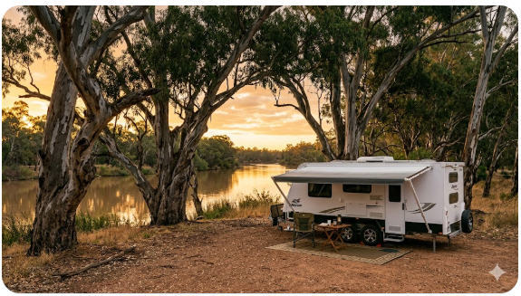
- The Murray River itself is the attraction — riverfront sites at Lyrup Flats, Bulyong Island, Hogwash Bend, Pike River and Katarapko Creek are outstanding but fill fast on long weekends and school holidays.
- Dump points are not at the free camping areas — you must plan your waste management before arriving. The nearest dump points are in Berri, Renmark, Waikerie and Loxton townships.
- Telstra is the only reliably functional network across much of the Riverland corridor. Optus and Vodafone coverage is patchy to non-existent at the river reserve sites.
- Summer temperatures in the Riverland regularly exceed 40°C — May through September is overwhelmingly the preferred season for senior travellers. May 2026 conditions are ideal.
- Firewood collection from Crown land is prohibited — bring your own or purchase locally. Many sites permit fires in contained braziers only; check current SA CFS fire ban status before lighting anything.
What You Will Find in This Guide
- Location, Address and GPS
- Can You Stay Overnight?
- Facilities — Toilets, Water and Dump Point
- Mobile Coverage and Wi-Fi
- Fuel — Finding the Cheapest Nearby
- How to Get There
- What to Expect on Arrival
- Safety for Senior Grey Nomads
- Medical and Emergency Contacts
- Dump Points, Water and Supplies Nearby
- Things to Do for Seniors
- Best Time of Year to Stop Here
- Fires, Generators and Overnight Etiquette
- Packing Checklist for Seniors
- GPS Coordinates and Postcodes
- Frequently Asked Questions
- Quick Verdict
1. Location, Address and GPS
The Riverland region of South Australia stretches approximately 200 kilometres along the Murray River from Blanchetown in the west to Renmark near the Victorian border. Free camping is scattered across this entire corridor. This guide covers the most significant and senior-accessible sites within that zone. The key reference towns, in order from Adelaide, are: Blanchetown, Waikerie, Barmera, Berri, Loxton and Renmark.📍 Key Free Camping GPS Coordinates — Riverland SA
Lyrup Flats Conservation Park Campground (near Berri):-34.2590, 140.6180
Katarapko Creek Camp (near Loxton):-34.4500, 140.5600
Hogwash Bend EA Camp (near Waikerie):-34.1750, 139.9800
Pike River Mouth (near Renmark):-34.1780, 140.7320
⚠️ All coordinates are within 50 metres of the stated locations and are provided as navigation guidance only. Confirm against on-site signage on arrival. Track conditions change seasonally.| Detail | Information |
|---|---|
| Region | Riverland, South Australia |
| Corridor extent | Blanchetown (postcode 5354) to Renmark (postcode 5341) |
| Primary highway | Sturt Highway (A20) — runs the full length of the Riverland |
| Key free camp postcodes | Berri 5343, Loxton 5333, Renmark 5341, Waikerie 5330, Barmera 5345 |
| Land manager | Department for Environment and Water (DEW) SA; some sites managed by local councils |
| Distance from Adelaide | Blanchetown: approx. 130 km | Renmark: approx. 254 km via Sturt Hwy |
| Distance from Mildura VIC | Renmark to Mildura: approx. 65 km via Sturt Hwy |
2. Can You Stay Overnight?
Yes — free overnight camping is permitted at designated reserve sites across the Riverland, but not everywhere along the river bank and not without conditions. This distinction is critical and the one most guides gloss over. The Riverland operates under a mixture of DEW-managed conservation parks, Crown land river reserves and council-managed reserves. Each category has slightly different rules. Here is what you need to know:- DEW conservation park sites (Lyrup Flats, Katarapko, Pike River): Camping is permitted and currently free as of May 2026 at designated camping areas. Self-contained vehicles are strongly preferred. Some sections require a free camping permit obtainable through the SA National Parks online booking system — check before arriving as this can change.
- Crown land river reserves (Hogwash Bend, Taplan, Qualco area): Overnight stays generally permitted for up to 48 hours. No facilities. Self-contained required. No fires in total fire ban periods.
- Council reserves in townships: Rules vary by council. Renmark Paringa Council, Berri Barmera Council and Loxton Waikerie Council each set their own conditions. Some township-adjacent reserves have been restricted to day use only — always verify locally before setting up.
- Private river frontage: Do not camp on unmarked river bank — much of it is private. If there is no sign explicitly permitting camping, do not assume it is allowed.
- If the area is full: Move on — do not park in ways that block access tracks or push onto private land. The townships of Berri, Renmark, Barmera and Loxton all have caravan parks that accept casual overnight stays if the free sites are at capacity.
3. Facilities — Toilets, Water and Dump Point
| Facility | What Is Available | What Seniors Should Know |
|---|---|---|
| Toilets | Pit toilets at Lyrup Flats and Katarapko; no toilets at most other river reserve sites | Pit toilets are basic composting or drop-style — bring your own toilet paper and hand sanitiser. Not suitable for those with severe mobility issues. Self-contained rigs with onboard toilet have a significant advantage here. |
| Potable water | Not available at any river reserve free camping site in the Riverland | Do not rely on river water even with filtration — Murray River water in this region can carry blue-green algae, agricultural runoff and other contaminants. Fill tanks in Berri, Renmark, Loxton or Waikerie before heading to any free camp site. |
| Dump point | Not at any free camping site — dump points are in townships only | Plan your dump point visit before reaching your camping site. Nearest dump points: Berri (Berri Visitor Centre area), Renmark (Renmark Caravan Park area), Loxton (township), Waikerie (township). Verify current locations at campermate.com.au/dump-points. |
| Showers | None at any free site in the Riverland | Onboard shower essential. Some township swimming pools offer coin showers — verify locally. |
| Bins | No bins at river reserve sites | Pack out all rubbish. This is strictly enforced by rangers. Bags of rubbish left at sites result in access restrictions being applied to the whole area. |
| Power | No mains power at any free site | Solar, battery banks or generator required. See generator rules in the etiquette section. CPAP users must have sufficient battery backup for multi-night stays. |
| Shade | Natural river gum shade at most sites — varies by specific spot chosen | Arrive early to secure a shaded position. In May the sun angle is low — shade from river gums is effective but not total. Bring your own shade awning as backup. |
- Site suitable for: Caravans, motorhomes and vans — larger rigs (over 8m total length) may struggle with some access tracks
- Road access: Sturt Highway sealed; most river reserve access tracks are unsealed gravel — 2WD suitable when dry, can become slippery after rain
- Site surface: Gravel and dirt — uneven in places, bring levelling blocks
- Camping permitted: Yes — self-contained strongly preferred, required at most sites
- Maximum overnight stay: 48 hours at most river reserves; 72 hours at some council sites — verify locally
- Boat ramp: Available at several sites including Berri, Renmark and Barmera foreshore areas
- Picnic tables: At Lyrup Flats and Katarapko; absent at most other sites
- Potable water: Not available at any free camping site — fill tanks in townships
- Mobile coverage: Telstra usable at most sites; Optus and Vodafone patchy to none
- TV reception: Reasonable on Sturt Highway corridor; reduced at remote river bend sites
- Rubbish bins: None — pack everything out
- Open fires: Subject to current SA CFS fire ban — check cfs.sa.gov.au daily
- Generator use: Permitted at most sites — quiet hours generally 9pm to 7am, though this is not always signed; apply common courtesy
- Number of sites: Varies — Lyrup Flats has approximately 15 to 20 designated spots; Katarapko similar; river reserve sites are informal and numbers depend on conditions
4. Mobile Coverage and Wi-Fi
Mobile coverage in the Riverland is one of the most misunderstood aspects of planning a stay here. The Sturt Highway towns — Blanchetown, Waikerie, Barmera, Berri, Loxton, Renmark — all have reasonable Telstra coverage for calls and data. The moment you leave the highway and head down a river access track toward a free camping site, coverage often drops sharply or disappears entirely. Telstra: Best network for the Riverland by a significant margin. Usable coverage along the Sturt Highway corridor. At most of the closer river reserve sites (Lyrup Flats, Katarapko main entry area) Telstra provides 3G to 4G for basic data. At more remote river bend sites and areas like Hogwash Bend, even Telstra can be one or two bars at best. Voice calls generally work; data speeds will be slow. Optus: Reliable in Berri, Renmark and Loxton towns. Drops out quickly on river reserve access tracks. Do not rely on Optus for river reserve camping. Vodafone / TPG: Town coverage only. No practical coverage at river reserve free camping sites.5. Fuel — Finding the Cheapest Nearby
Fuel pricing in the Riverland follows the typical regional SA pattern — township prices are higher than Adelaide metro but lower than the truly remote outback. The good news is that the Sturt Highway corridor is well-serviced by fuel stops and you will never be more than 40 to 50 kilometres from a bowser along the main route. Key fuel stops along the Riverland corridor (west to east):- Blanchetown: One fuel stop at the highway junction — petrol and diesel available. Prices tend to be the highest in the region due to limited competition. Fill up in Adelaide if possible before heading out.
- Waikerie: Multiple fuel options in town — both petrol and diesel, with some price variation between sites. Worth comparing before filling.
- Berri: Best fuel pricing in the central Riverland — multiple competing bowsers and a Coles Express location that often offers discount vouchers for frequent shoppers. Both petrol and diesel available.
- Loxton: Fuel available in town — standard regional pricing. Diesel available.
- Renmark: Multiple fuel options near the Sturt Highway — competitive pricing for a regional centre. Best stop for diesel at the eastern end of the Riverland before crossing into Victoria.
6. How to Get There
From Adelaide (westbound approach): Take the A20 Sturt Highway from the Adelaide metropolitan area through Gawler and continue northeast. The Sturt Highway is the backbone of the entire Riverland corridor. From Adelaide’s CBD to Blanchetown is approximately 130 km and takes around 90 minutes under normal conditions. Continue along the Sturt Highway to reach Waikerie (approx. 185 km from Adelaide), Barmera (approx. 225 km), Berri (approx. 235 km), Loxton (approx. 255 km via the B62 diversion south of Berri) and Renmark (approx. 254 km direct via A20). For specific river reserve access tracks, turn off the Sturt Highway at the signed turnoffs for each reserve — these are generally well-signed but the tracks themselves vary in quality. From Mildura VIC (eastbound approach): Cross the Murray at Renmark or via the Paringa bridge and join the Sturt Highway heading west. From Mildura to Renmark is approximately 65 km. From Renmark you travel west through the Riverland to Berri, Barmera, Loxton and beyond. This direction gives you access to the eastern Riverland sites first — Pike River, Lyrup Flats and Katarapko.Driving Notes for Seniors Towing Vans
- The Sturt Highway is generally wide, sealed and well-maintained through the Riverland — it is not a difficult towing road. However, the section between Gawler and Blanchetown has sections of single-lane highway with narrow shoulders and limited overtaking lanes. Allow faster traffic to pass when safe to do so.
- The river reserve access tracks are a different matter entirely. Many are unsealed gravel with corrugations, narrow widths and low-hanging branches. Rigs over 8 metres total length should assess access carefully. When in doubt, walk the track before reversing your van in.
- Blanchetown has a low-clearance bridge approach on some routes — not an issue on the Sturt Highway main route but relevant if navigating off the highway.
- Roadworks are periodic on the Sturt Highway between Gawler and Blanchetown — allow extra time and check SA road conditions via the DPTI SA website or the 1300 361 033 road conditions line before departing.
- School zones are active in Berri, Renmark, Loxton and Waikerie townships during school term — slow down through all townships regardless of signage as pedestrian activity near schools is significant in these close-knit communities.
- Kangaroo and livestock activity is high on the Sturt Highway at dawn and dusk, particularly between Blanchetown and Waikerie. Avoid driving in these conditions if possible when towing.
7. What to Expect on Arrival
What the Riverland actually looks like when you pull into a free camping spot is genuinely different from the polished photos most travel sites use. Here is the honest picture:- The river itself is beautiful: The Murray River through the Riverland is wide, brown, slow-moving and edged with ancient river red gums. Sunrises and sunsets over the water are genuinely spectacular. This is not hyperbole — the light in the Riverland is exceptional and most grey nomads who stop here end up staying longer than planned.
- The sites are informal: There are no numbered bays, no concrete pads, no park managers greeting you. You choose your spot within the designated area. Popular sites fill from Thursday to Sunday and are largely empty Monday to Wednesday — plan accordingly.
- Ground conditions vary: After rain, clay-heavy river flats can be soft enough to bog a heavy motorhome or van. May brings occasional rain events to the Riverland — check the ground before you commit your weight to it. If other grey nomads are already set up without incident the ground is likely fine.
- Insects are real: Murray midges (tiny biting flies, sometimes called sand flies locally) are active at certain times of year — less so in May but still present near the water at dawn and dusk. Fly screens, insect repellent and long sleeves at twilight are not optional in the Riverland.
- Privacy varies enormously: Some river reserve spots are isolated and peaceful — you may have the whole area to yourself mid-week in May. Long weekend arrivals will find sites packed with families, boats and noise. The “free camping at the Murray” experience mid-week in May is a genuinely different product from Easter weekend.
8. Safety for Senior Grey Nomads
Personal Safety
- The Riverland is one of the safer regions in South Australia for grey nomad camping. Serious crime at river reserve sites is rare. However, petty theft from unlocked vehicles does occur, particularly at popular long-weekend sites. Lock your vehicle and tow vehicle at all times and do not leave valuables visible.
- Solo senior travellers should choose sites where other grey nomads are already present rather than isolated remote spots. Mid-week in May there can be very few people at some river reserves — if you are travelling solo, Lyrup Flats or the Berri foreshore areas are better choices than remote Katarapko creek sections.
- River banks in the Riverland can be undercut and unstable — the river red gum roots hold the bank but the drop-off to the water can be steep and sudden. Do not walk close to the bank edge, particularly at night or after rain. This is a specific and underreported hazard for senior travellers who may be less steady on their feet.
- Snakes are present in the Riverland, including Eastern Brown snakes — one of the most venomous in Australia. In May the weather is cooling and snake activity reduces but does not stop. Always look before you step, particularly around log piles, long grass and river bank vegetation. Wear enclosed footwear when walking off the cleared camping area.
- River swimming carries risks — strong currents exist even in apparently calm sections of the Murray. The river temperature in May is cold. If you choose to swim, do not swim alone and be aware of boat traffic on the main river channel. Fishing from the bank is a safer and very popular activity for seniors at these sites.
Trip Safety
- Tell someone not travelling with you your planned location and expected next check-in point before losing coverage. The Emergency Plus app on your phone uses GPS to give your coordinates even without coverage — if you can reach any signal, you can relay those coordinates.
- For CPAP users: the Riverland’s free camping sites have no mains power. A lithium battery bank or quality AGM battery system with solar is essential for multi-night stays. Running a generator overnight for CPAP is socially unacceptable and against the quiet hours etiquette at these sites. A dedicated CPAP battery solution is the correct approach — this is worth planning before you leave home. See our guide to sleeping in a campervan in Australia for power options.
- Blood pressure medication, diabetes medication and other prescription medications should be stored correctly. Riverland summer temperatures can destroy medications stored in vehicles — in May temperatures are manageable but a dedicated medication cooler is still wise for heat-sensitive prescriptions.
- For caravan security at Riverland sites, read our detailed breakdown of how caravan theft happens in Australia — the patterns that apply in popular free camping areas are real and worth understanding before you arrive.
- Review the Grey Nomad Road Safety Checklist before departing for the Riverland if you have not driven a long regional highway route recently.
9. Medical and Emergency Contacts
| Service | Address | GPS (approx. town centre) | Phone |
|---|---|---|---|
| Emergency — Police, Fire, Ambulance | All of Australia | N/A | 000 |
| Healthdirect — 24hr medical advice | Australia-wide telephone service | N/A | 1800 022 222 |
| Berri Hospital (primary regional hospital) | Vaughan Terrace, Berri SA 5343 | -34.2830, 140.5990 | (08) 8582 9000 |
| Renmark Hospital | Renmark Avenue, Renmark SA 5341 | -34.1710, 140.7470 | (08) 8580 2500 |
| Loxton Hospital | Beckwith Street, Loxton SA 5333 | -34.4440, 140.5730 | (08) 8584 8200 |
| Royal Flying Doctor Service SA | Port Augusta base serves regional SA | N/A | rfds.org.au |
10. Dump Points, Water and Supplies Nearby
| Need | Best Nearby Option | Notes |
|---|---|---|
| Dump point | Berri (near Visitor Centre / Saleyard Road area), Renmark, Loxton, Waikerie | Verify current dump point locations at campermate.com.au/dump-points before arriving — locations can change. Use dump point before departing town, not after setting up at the free site. |
| Fresh water | All Riverland townships — taps at visitor centres, fuel stops and caravan parks | Do not use river water. Fill all tanks in town. Carry 20L extra drinking water minimum per person for multi-night river reserve stays. |
| Groceries | Woolworths Berri, Woolworths Renmark, IGA Loxton, IGA Waikerie | Full supermarket shopping available in Berri and Renmark. IGA stores in Loxton and Waikerie for basics. Stock up for 3 to 4 days if heading to remote sites. |
| Fuel | Berri (best pricing), Renmark, Loxton, Waikerie, Blanchetown | Check petrolspy.com.au before filling. Diesel available at all major stops. Fill before leaving the Sturt Highway for any river reserve site. |
| Pharmacy | Berri (multiple pharmacies), Renmark, Loxton | Fill prescriptions before arriving in the Riverland. Small towns may not stock specialist medications. Berri and Renmark have the best pharmacy range. |
| Major supplies / hardware | Berri and Renmark have the best range of general stores and hardware | If you need caravan parts or hardware items, Berri and Renmark have the best options. Smaller towns have limited range. Plan for this before heading to remote sites. |
11. Things to Do for Seniors
| Activity | Location | Why Seniors Like It |
|---|---|---|
| Murray River fishing | River bank at any free camp site | Seated bank fishing requires minimal mobility. Yellowbelly (golden perch), Murray cod and carp are all catchable. SA fishing licence required — available online. Completely free, immensely popular with grey nomads, and an excellent reason to extend your stay mid-week. |
| Banrock Station Wine and Wetlands Centre | Holmes Road, Kingston on Murray (near Barmera) — approx. 14 km from Barmera | Flat, well-maintained boardwalk through wetlands — genuinely accessible for seniors with walking aids. Award-winning winery with cellar door tastings. Cafe on site. One of the genuine highlights of the Riverland that is easy to miss if you just follow the highway. |
| Berri Riverfront Walk | Berri township foreshore | Flat sealed path along the river. Benches at regular intervals. Public toilets on route. Excellent bird watching — white cockatoos, cormorants, sacred ibis. Very manageable for seniors with limited mobility. |
| Renmark Visitor Centre and Olivewood Historic Homestead | Murray Avenue, Renmark | Air-conditioned visitor centre with excellent local history displays. Olivewood homestead is a National Trust property telling the story of the original Chaffey irrigation settlement. Entry fee applies to homestead — check locally for current prices. Flat grounds, accessible. |
| Lake Bonney foreshore, Barmera | Barmera township | Flat foreshore, swimming beach, caravan-accessible parking. Lake Bonney is famous as the site where Donald Campbell attempted his water speed record in 1964. The historical connection is genuinely interesting and few grey nomad guides mention it. A quiet mid-week walk around the foreshore with this context is memorable. |
What Most Grey Nomad Guides Miss About the Riverland
The Riverland is not just the Murray River with some citrus orchards behind it. The region contains some of the most important Aboriginal cultural landscape in southern Australia. The Ngaiawang, Ngawait and Maraura peoples have maintained connection to this river country for tens of thousands of years. The river red gum forests that line the Murray in this region are ancient cultural landscapes — many trees are scarred from bark canoe and shield removal by Aboriginal craftspeople over centuries.12. Best Time of Year to Stop Here
| Season | What It Is Like | Senior Verdict |
|---|---|---|
| Summer (Dec–Feb) | Extremely hot — temperatures regularly exceed 40°C and can reach 46–47°C. Heatwaves are common and prolonged. River swimming is popular with families. Sites packed and noisy on weekends. Total fire ban periods frequent. | ❌ Not recommended for senior grey nomads. Heat risk is severe for those with cardiovascular conditions, diabetes or who take blood pressure medications. If you must be here in summer, stay in caravan parks with mains power for air conditioning. |
| Autumn (Mar–May) | Temperatures drop to comfortable ranges — 18–28°C daytime in March and April, dropping further in May to 14–22°C typically. Citrus harvest. Fewer crowds. River conditions excellent. May is the sweet spot. | ✅ Excellent — May is the best single month in the Riverland for senior grey nomads. Comfortable temperatures, light crowds mid-week, superb bird watching, harvest produce at farm gates, beautiful light. |
| Winter (Jun–Aug) | Cool to cold — overnight temperatures can drop to 4–7°C or below. Frosty mornings are common. Days are short but often sunny and crisp. River levels can be higher. Sites largely empty mid-week. | ⚠️ Manageable for well-equipped travellers. Bring serious insulation for overnight stays. The cold is dry and the days are often beautiful, but heating requirements mean generator use increases — factor this into your site etiquette. |
| Spring (Sep–Nov) | Warming quickly through October and November. Wildflowers in the mallee country surrounding the Riverland. River flows settling after winter. School holidays in September create busy periods. | ✅ Good — September is excellent. Avoid school holiday long weekends. November begins to warm significantly and some days in November can reach 36–38°C, foreshadowing the summer pattern. |
13. Fires, Generators and Overnight Etiquette
- Open fires: Permitted at river reserve free camping sites when no fire ban is in force and where local signage permits them. Always check the current SA Country Fire Service fire danger rating before lighting anything. Visit cfs.sa.gov.au for the current fire danger rating and any Total Fire Ban declarations. In a Total Fire Ban, no fires of any kind are permitted — including gas BBQs in some declared conditions. Do not assume the absence of a visible fire ban sign at the campsite means no ban is in force. Check online or radio before every fire.
- Firewood collection: Collecting firewood from Crown land and conservation parks is prohibited in South Australia. Dead wood on the ground in river red gum habitat is critical habitat for lizards, insects and small mammals — removing it is environmentally damaging and illegal. Purchase firewood from roadside sellers or hardware stores in Berri, Renmark or Loxton before heading to the free site.
- Generators: Permitted at most Riverland free camping sites but should be treated as a courtesy issue as much as a rule issue. Standard etiquette is no generators before 7am or after 9pm. At sites where neighbours are close, consider whether your generator is impacting the very experience that drew everyone to this remote river site. A quality lithium battery system with solar eliminates generator noise entirely — worth the investment for regular grey nomads.
- Noise and lights: The Riverland attracts grey nomads specifically because it is quiet and dark at night. Bright LED lights pointed outward and loud late-night conversation are the two most common complaints from other campers at these sites. Use directional lighting and be aware of your neighbour’s experience.
- Rubbish: No bins at any river reserve free camping site. Everything that comes in must leave with you. Rangers do patrol and have the authority to restrict or close sites where rubbish problems become chronic. The sites that remain open and free are the ones where the camping community self-manages their rubbish responsibly.
- Grey water and sewage: Do not discharge grey water or sewage onto the ground or into the river at any Riverland free camping site. This is illegal under SA Environment Protection legislation and is the single fastest way to get a river reserve site closed permanently. Use your onboard holding systems and dump in town.
14. Packing Checklist for Seniors
| Item | Why It Matters at Riverland SA Free Camps | ☐ |
|---|---|---|
| Full fresh water tanks + 20L extra drinking water | No potable water at any river reserve free camp site. River water is not safe to drink even filtered. | ☐ |
| CPAP battery solution (lithium battery bank) | No mains power at free camp sites. Running a generator overnight for CPAP is disruptive and socially unacceptable. A dedicated battery solution is essential for multi-night stays. | ☐ |
| Insect repellent and fly screens in good repair | Murray midges and mosquitoes are active near the river, particularly at dawn and dusk. May is lower risk but not zero risk. Fly screens on all openings are non-negotiable. | ☐ |
| Levelling blocks and chocks | River reserve ground is uneven. Good levelling is essential for comfortable sleep and appliance function (especially absorption fridges). | ☐ |
| Snake-proof enclosed footwear | Eastern Brown snakes are present in the Riverland year-round. Enclosed shoes when walking off the cleared camping area are essential. | ☐ |
| SA fishing licence and fishing gear | River bank fishing is free, accessible and one of the great Riverland pleasures for grey nomads. SA fishing licence available online before you leave home. | ☐ |
| Firewood (purchased, not collected) | Collecting firewood from Crown land is prohibited. Buy from roadside sellers or hardware stores in Berri or Renmark before reaching your site. | ☐ |
| Hema Explorer app downloaded and up to date | Many river reserve access tracks are not on Google Maps. Hema covers them. Download before leaving the last town with coverage. | ☐ |
| Binoculars | The Riverland’s bird life is extraordinary. You will use binoculars every morning at the river’s edge. Non-negotiable for the full experience. | ☐ |
| UHF CB radio | Mobile coverage is unreliable at river reserve sites. A UHF CB radio allows communication with other campers and passing trucks on remote tracks. Essential for safety at remote sites. | ☐ |
| Grey water and sewage holding confirmed | Grey water on the ground or sewage discharge is illegal at all Riverland river reserve sites and will result in site closure if detected. Confirm holding systems are functional before departing. | ☐ |
| Rubbish bags and a plan to pack out | No bins at any river reserve free site. Pack it in, pack it out. This is non-negotiable and critical to keeping these sites open. | ☐ |
COPY PROMPT ➔ ASK AI ➔ SAVE TO FORM ➔ ADD SPOT PIN ➔ GET DIRECTIONS
📍 Interactive map — find free camps, rest areas and overnight stops. Enable location for best results.
15. GPS Coordinates and Postcodes
| Location | Address and Postcode | GPS (approx. within 50m) | Notes |
|---|---|---|---|
| Lyrup Flats Conservation Park Camp | Lyrup Flats, near Berri SA 5343 | -34.2590, 140.6180 | Best-maintained DEW free camp in the central Riverland. Access via Lyrup Road off Sturt Hwy. Confirm on arrival against current signage. |
| Katarapko Creek Campground | Katarapko Creek, near Loxton SA 5333 | -34.4500, 140.5600 | Remote river setting. Access track quality varies. GPS is approximate to camp entry — confirm on arrival. Check DEW for current access conditions. |
| Hogwash Bend EA Camp | Waikerie area SA 5330 | -34.1750, 139.9800 | Western Riverland. Environment Agency managed. Access track requires careful assessment for large rigs. Coordinate is approximate — use Hema for precise track navigation. |
| Berri Hospital (nearest major hospital — central Riverland) | Vaughan Terrace, Berri SA 5343 | -34.2830, 140.5990 | Primary regional hospital for central Riverland. Phone: (08) 8582 9000. Follow hospital signage from Sturt Hwy in Berri. |
| Renmark (nearest major township — eastern Riverland) | Murray Avenue, Renmark SA 5341 | -34.1710, 140.7470 | Township centre. Renmark Hospital, fuel, supermarket, dump point and pharmacy all within township. 254 km from Adelaide via Sturt Hwy. |
16. Frequently Asked Questions
Is Riverland SA free camping genuinely free?
Yes — as of May 2026, camping at the designated river reserve and DEW conservation park sites across the Riverland SA is free of charge. However, some DEW sites have introduced or trialled a free permit system through the SA National Parks online booking portal. This does not currently cost money but does require registration. Verify current permit requirements at parks.sa.gov.au before arriving at any DEW-managed site. Council-managed sites and Crown land reserves do not currently charge fees, but this can change without notice.Can caravans and motorhomes stay overnight at Riverland SA free camping sites?
Yes — caravans and motorhomes are the primary users of Riverland free camping sites and most sites are designed with this in mind. The critical constraint is rig size versus track access. Rigs over 8 metres total length (van plus tow vehicle combined) may struggle with some of the narrower river reserve access tracks, particularly at Katarapko Creek and the more remote Hogwash Bend area. Lyrup Flats and the Berri foreshore areas are more accessible for larger rigs. Always walk a track before reversing your rig in if you have any doubt about width or clearance.What is the GPS for Riverland SA free camping?
The Riverland covers a 200-kilometre stretch of the Murray River and there is no single GPS coordinate. The key sites are: Lyrup Flats Conservation Park Camp (-34.2590, 140.6180), Katarapko Creek Camp (-34.4500, 140.5600), and Hogwash Bend EA Camp (-34.1750, 139.9800). All coordinates are within 50 metres of the site entry area and must be confirmed against on-site signage on arrival. Use WikiCamps Australia or Hema Explorer for the most accurate navigation to individual river reserve tracks.Are there toilets at Riverland SA free camping sites?
Basic pit toilets are available at Lyrup Flats Conservation Park and Katarapko Creek main campground. Most other river reserve free camping sites in the Riverland have no toilet facilities at all. Self-contained rigs with onboard toilets have a significant advantage here. If you are camping at a site without toilet facilities, you are legally required to manage all human waste in your onboard holding system — burying waste near the river is illegal and ecologically destructive in this environment.Is there a dump point at Riverland SA free camping sites?
No — there are no dump points at any of the Riverland river reserve free camping sites. All dump points are located in the townships. As of May 2026, dump points are available in Berri, Renmark, Loxton and Waikerie. Verify current dump point locations at campermate.com.au/dump-points before arriving. Plan your logistics so you use the dump point in town before driving out to the free site, not after you have already set up.Can you get potable water at Riverland SA free camping sites?
No — there is no potable water at any river reserve free camping site in the Riverland. Fill all tanks in town before heading to any free site. Do not drink from the Murray River — it is subject to blue-green algae blooms, agricultural chemical runoff and other contaminants that make it unsafe to drink even with standard filtration. Carry a minimum of 20 litres of drinking water per person as an emergency reserve beyond your main tank supply.Is Riverland SA free camping safe for solo senior travellers?
Generally yes, with specific caveats. The Riverland is not a high-crime region and serious incidents at free camping sites are rare. Solo senior travellers should choose sites where other grey nomads are already present — Lyrup Flats and the Berri foreshore areas are the best choices for solo seniors due to their higher usage and closer proximity to town. Avoid remote, isolated river sites if you are travelling alone. Tell someone your planned location and expected check-in time before losing coverage. See our guide to grey nomad safety tips for a comprehensive overview of solo travel safety practices.What is the nearest hospital to Riverland SA free camping?
It depends on which site you are at. For the central Riverland (Lyrup Flats, Berri foreshore, Pike River area), Berri Hospital on Vaughan Terrace, Berri is the nearest — phone (08) 8582 9000, approximately 10 to 35 km depending on your specific site. For the eastern Riverland (Renmark area, Pike River), Renmark Hospital on Renmark Avenue is closest — phone (08) 8580 2500. For the western Riverland (Hogwash Bend, Waikerie area), Waikerie Health Service is the nearest — verify the current phone number before your trip. For any life-threatening emergency, call 000 immediately. If you have no signal, drive to the Sturt Highway and flag down traffic.Can you fish in the Murray River at Riverland SA free camping sites?
Yes — river bank fishing from the free camping sites is one of the great Riverland experiences for grey nomads and it is perfectly legal with the correct licence. You need a valid SA Recreational Fishing Licence, available online through the PIRSA (Primary Industries and Regions SA) website before you arrive. Target species include yellowbelly (golden perch), Murray cod (size and bag limits apply — check current regulations before fishing), redfin perch, carp and bream. May is an excellent fishing month in the Riverland — water temperatures are dropping, the river is less busy with boat traffic than summer, and the fish are active. A folding chair, a simple bottom rig with worms or yabbies, and an early morning on the river bank at a Riverland free camp is an experience many grey nomads consider the highlight of their entire trip through South Australia.17. Quick Verdict
The Riverland SA free camping scene is, at its best, genuinely outstanding. When you are sitting in a camp chair under a river red gum at Lyrup Flats on a May morning watching pelicans glide past on the Murray while a kettle heats on a gas ring and there is not another soul visible in either direction — that is the grey nomad experience at its purest and it costs nothing. The river views, the bird life, the citrus harvest, the accessible wineries, the flat foreshore walks in the townships and the sheer quiet of mid-week camping in the Riverland in autumn place this region in the top tier of grey nomad destinations in South Australia. The drive from Adelaide is easy and the Sturt Highway is one of the gentler highway towing experiences in the country. The genuine weaknesses are real and worth stating clearly. There is no potable water and no dump point at any free camping site — the logistics require planning that some travellers find inconvenient. The access tracks to the better remote sites can be challenging for larger rigs and need careful assessment after rain. Mobile coverage drops out quickly once you leave the Sturt Highway corridor. Summer temperatures make this region dangerous for senior travellers without air conditioning — it is simply not a summer destination for free camping. And the sites are genuinely crowded on long weekends and school holidays in a way that completely changes the experience. Mid-week, May through September: that is when the Riverland free camping experience works at its highest level.Free campsites and powered sites fill fast during school holidays and peak season. If your preferred site is already gone, search remaining accommodation options below to explore the region.
Accommodation and flight search powered by Expedia. Booking through this search supports this website at no extra cost to you. As an affiliate, I earn from qualifying purchases at no extra cost to you.

As an affiliate, I earn from qualifying purchases at no extra cost to you.
Exclusive Offer: Get 5% OFF all StarterStopper immobiliser products with promo code: RTV5
Visit StarterStopper.com to see our data-backed security solutions
As an affiliate, I earn from qualifying purchases at no extra cost to you.