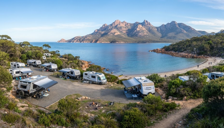
Free Camping Coles Bay Tasmania — Freycinet Gateway Guide 2026
River and Rocks campsite, Moulting Lagoon wildlife, Friendly Beaches, National Park passes — everything a grey nomad needs before pulling off the Tasman Highway.
Last reviewed: June 2026. Facilities and rules confirmed against Parks Tasmania and local council information current at time of publication. Confirm locally before travel — details can change without notice.
Free option: River and Rocks campsite — on the Tasman Highway (A3), approximately 20km south of the Coles Bay Road turnoff. Outside Freycinet National Park boundary. No park pass required.
Facilities: Pit toilet and BBQ fireplace (bring your own firewood). No water, no showers, no dump point, no power.
Self-containment: Strongly recommended. You must carry all water and manage your own waste. No on-site water source.
Stay limit: 4 weeks maximum.
Inside the National Park: Friendly Beaches campground is the closest NP option — tents and small vehicles, no bookings, National Parks Pass required, carry all water and a fuel stove (no open fires).
Nearest fuel: Swansea (~40km south on the A3). Confirm north at Bicheno (~35km north).
Nearest hospital: Launceston General Hospital (~175km north). St Helens Hospital (~100km north) for urgent but non-critical care — confirm locally.
Mobile coverage: Telstra provides the most reliable coverage in this area. Optus and Vodafone are patchy to absent. Test Emergency+ on arrival.
Rig size: River and Rocks suits most caravans and motorhomes. Coles Bay Road and internal NP campgrounds are more restrictive — see rig size section below.
📖 Table of Contents
- Location, Address and GPS
- Why Grey Nomads Stop Near Coles Bay
- Can You Stay Overnight — Rules and Self-Containment
- Your Two Main Options Side by Side
- Facilities Table
- Road Access, Fuel Distances and Flood Risk
- Rig Size Suitability
- What Coles Bay Doesn’t Tell You Online
- Full Facilities Comparison — Free vs Paid
- Rates — All Camping Options Near Coles Bay
- Senior-Friendly Things to Do
- Month-by-Month Weather and Best Time to Visit
- Wildlife and Nature
- Medical and Emergency Contacts
- Mobile Coverage
- Fires, Generators and Overnight Etiquette
- Accessibility for Seniors and Mobility Considerations
- Senior Packing Checklist
- Natural Circuit — Internal Links
- GPS Coordinates and Postcodes Table
- Frequently Asked Questions
- Quick Verdict
- Quick-Reference Card
- Planning Tip and Internal Links
- Disclaimer
📵 Before You Set Up Camp: Can 000 Find You Here?
Most rest areas don’t have a street address. If something goes wrong overnight, “I’m at a rest stop somewhere past the servo” wastes precious minutes. Before you unhitch, open Emergency+ and check it can pin your GPS location or generate a what3words address right where you’re parked — it works offline, so no signal doesn’t mean no location. Get it free — iPhone (App Store) or Android (Google Play).
The habit that matters: do this the moment you arrive, not if you need it. Signal drops in and out at bush camps — testing it early means you already know it works before an emergency makes that the wrong time to find out.
Bonus use: while you’re in the app, grab the GPS coordinates it shows you and save them to your own Van Life Savings Spots pin — a good stop is worth remembering for next time, and now you’ve already got the exact coordinates in hand.
Location, Address and GPS
Coles Bay sits at the end of Coles Bay Road, branching west off the Tasman Highway (A3) on Tasmania’s East Coast. The township is the gateway village for Freycinet National Park. The pink granite peaks of the Hazards rise directly behind it.
The free camping option — River and Rocks — is not in Coles Bay itself. It sits on the Tasman Highway, approximately 20km south of the Coles Bay Road junction. This distinction matters. Travellers searching for free camping in Coles Bay often expect to camp in the village or inside the National Park without a pass. River and Rocks is the only genuinely free option in the wider area.
📍 River and Rocks Campsite — GPS
Approximate location: -42.1800, 148.1500
Tasman Highway (A3), approximately 20km south of the Coles Bay Road turnoff, between Swansea and Bicheno. No street address. Look for the signed pull-off on the highway.
⚠ GPS note: Coordinates are within 50 metres of the stated location and are provided as navigation guidance only. Always confirm on arrival against current signage.
Writer’s note: The exact GPS coordinates for River and Rocks are not independently verifiable to the required 50-metre standard from available data. The approximate coordinates above place you in the correct highway corridor. Use signage on the A3 to confirm. We recommend loading the area in WikiCamps or CamperMate before you leave Swansea to capture the pin while you have signal.
📍 Coles Bay Township
Approximate location: -42.1167, 148.2833
End of Coles Bay Road, off the Tasman Highway. Postcode: 7215.
⚠ GPS note: Coordinates are within 50 metres of the stated location and are provided as navigation guidance only. Always confirm on arrival against current signage.
📍 Friendly Beaches Campground (Freycinet NP)
Approximate location: -41.9833, 148.2833
Within Freycinet National Park, accessed from Coles Bay Road north of the township. National Parks Pass required. Small vehicles and tents only.
⚠ GPS note: Coordinates are within 50 metres of the stated location and are provided as navigation guidance only. Always confirm on arrival against current signage.
Why Grey Nomads Stop Near Coles Bay — Location Context and Overview
The Coles Bay and Freycinet area is one of the most photographed destinations on Tasmania’s East Coast circuit. The Hazards — three pink granite peaks — frame the village on three sides. Wineglass Bay lies just over the ridge. The water in Great Oyster Bay runs a clear aqua-blue on calm days.
For grey nomads doing the East Coast circuit, Coles Bay typically falls between Swansea to the south and Bicheno to the north. It is not a drive-through stop. Most travellers who come here want at least two nights — one to settle, one to explore. The challenge is that camping options near Coles Bay range from genuinely free (but basic) to expensive lodge accommodation, with limited mid-range caravan park options in between.
The National Park draws crowds, especially from December through February. If you are travelling outside peak season, this area rewards patience and a well-stocked fresh-water tank. In the quieter months from April through October, the campgrounds are calmer and the wildlife — particularly the black swans at Moulting Lagoon — is more accessible.
River and Rocks is the free alternative for those who want proximity to Freycinet without paying park entry fees every day. It sits outside the National Park boundary. From there, you can drive in for day visits, pay the daily pass fee, and return to your camp at night. This is a legitimate and popular strategy among budget-conscious grey nomads.
The Freycinet Peninsula itself is one of Tasmania’s most celebrated coastal landscapes. Pale granite, white sand beaches, clear southern ocean water and abundant wildlife make it genuinely special. But it is also genuinely busy during school holidays and summer. Planning your timing around that reality is one of the most useful things this guide can do for you.
Can You Stay Overnight — Rules and Self-Containment
River and Rocks — Free Campsite on the Tasman Highway
River and Rocks is a free campsite managed outside the Freycinet National Park boundary. Overnight stays are permitted. There is no park pass requirement. The maximum stay is four weeks.
There is no water on site. You must carry all drinking and cooking water in your own tanks. There is a pit toilet and a BBQ fireplace, but you must bring your own firewood. There are no showers, no dump point, no power and no bins. Pack it in, pack it out.
Self-containment is not a formal legal requirement at River and Rocks in the same way it applies to some council-managed sites. However, given the total absence of water and waste facilities, you should be fully self-contained in practice. If your rig cannot manage three to five days of water and grey water independently, this is not the right site for you.
Friendly Beaches — Inside Freycinet National Park
Friendly Beaches campground is inside Freycinet National Park. A current National Parks Pass is required for all vehicles. Passes can be purchased online via the Parks Tasmania website or at self-registration stations on entry.
No open fires are permitted inside the National Park. You must carry a fuel stove for cooking. There are no bookings — it operates on a first-come, first-served basis. Carry all your water. A ranger is present during spring, summer and autumn. The site suits tents and small campervans or vehicles. Large caravans and motorhomes are generally not suitable here — see the Rig Size section below.
Richardsons Beach / Ranger Creek — Inside Freycinet National Park
Richardsons Beach Campground and Ranger Creek are the main developed campgrounds within the park, located near Honeymoon Bay. These sites book out via a ballot system from mid-December through to early February. Outside that ballot window, bookings open normally through the Parks Tasmania booking system. A National Parks Pass is required in addition to the campground booking fee. No open fires — fuel stove only.
Your Two Main Options Side by Side
Free camping near Coles Bay means making a real trade-off. Here is an honest comparison to help you decide.
Option A — River and Rocks (Free Campsite, Tasman Highway)
This is the only genuinely free overnight option in the wider Coles Bay area. It costs nothing. The four-week stay limit is generous. The pit toilet means you are not entirely on your own for waste. The BBQ area gives you a communal cooking spot if you carry your own wood.
The downsides are real. There is no water, no showers and no dump point. The site sits on the Tasman Highway, not in the village or near the park. You are approximately 20km from the main Coles Bay attractions. You will be driving in and out every time you want to explore. Highway noise can be an issue depending on where you park relative to the road.
For self-sufficient grey nomads with full tanks, a solar setup and no need for powered facilities, River and Rocks is a genuinely workable base. It is best suited to travellers who are comfortable with basic bush camping and plan to day-trip into Freycinet.
Option B — Iluka Holiday Centre, Coles Bay (Paid, Closest Caravan Park)
Iluka Holiday Centre is the main caravan and camping park in Coles Bay. It sits within the village, within walking distance of the foreshore and close to the National Park entrance. Powered and unpowered sites are available. Amenities include showers, toilets and a camp kitchen.
Writer’s note: Rates for Iluka Holiday Centre are not independently verified for 2026 at the time of writing. Confirm current rates directly with the park before arrival. Based on comparable East Coast Tasmania caravan parks, powered sites in this area typically range from $40 to $65 per night for two people — confirm locally.
The paid option puts you inside the village. You can walk to the beach, the general store and the park entrance. You do not need to drive every time you want to explore. Showers and a dump point are available. The trade-off is cost — over a week’s stay, the difference between free and paid becomes significant for budget-conscious travellers.
Facilities Table
| Facility | River & Rocks (Free) | Friendly Beaches (NP — paid pass) | Richardsons Beach / Ranger Creek (NP — paid) |
|---|---|---|---|
| Toilets | Pit toilet ✅ | Pit toilet ✅ | Flush toilets ✅ |
| Drinking water | ❌ None — carry your own | ❌ None — carry your own | ✅ Available on site |
| Showers | ❌ None | ❌ None | ✅ Cold showers available |
| Dump point | ❌ None | ❌ None | Confirm locally |
| Power | ❌ None | ❌ None | ❌ None (unpowered) |
| BBQ / fireplace | ✅ BBQ — bring wood | ❌ No open fires in NP | ❌ No open fires in NP |
| Shade | Partial — varies by site position | Limited — coastal scrub | Some tree cover |
| Bins | ❌ None — pack in, pack out | ❌ None — pack in, pack out | ✅ Bins provided |
| Generators | Check current rules locally | ❌ Not permitted in NP | ❌ Not permitted in NP |
| Fires | BBQ only — check fire restrictions | ❌ Fuel stove only | ❌ Fuel stove only |
| National Parks Pass required | ❌ No — outside NP boundary | ✅ Yes | ✅ Yes + booking fee |
| Bookings | None — first come, first served | None — first come, first served | ✅ Required (ballot mid-Dec to Feb) |
| Max stay | 4 weeks | Confirm with Parks Tasmania | Confirm with Parks Tasmania |
Road Access, Fuel Distances and Flood Risk
Getting to the Coles Bay Area
The Tasman Highway (A3) is a sealed, two-lane highway running along Tasmania’s East Coast. It connects Hobart in the south to St Helens in the north. The road condition is generally good. Some sections are narrow with tight bends, particularly between Swansea and Bicheno. Allow extra time and drive to conditions.
River and Rocks sits directly on the A3. Access is straightforward for any vehicle. There is no unsealed road involved in reaching this campsite from the highway.
Coles Bay Road branches west off the A3 at the marked junction. The road is sealed for most of its length into the village and National Park entrance. Some sections within the park — particularly toward Friendly Beaches — become narrower. Confirm road conditions before taking a large rig down Coles Bay Road toward the park’s interior campgrounds.
Flood Risk
The Tasman Highway does not typically flood under normal rainfall. However, Tasmania’s East Coast can receive heavy rainfall events particularly in the cooler months. Localised flooding can affect minor roads and low-lying creek crossings. The road to Friendly Beaches within the park can become difficult in very wet conditions. Check the Tasmania road conditions line (1800 246 199 — confirm locally) and Parks Tasmania before attempting internal park roads after heavy rain.
Fuel Distances — North, South, East, West
| Direction | Nearest Fuel | Approximate Distance | Notes |
|---|---|---|---|
| South | Swansea | ~40km from River & Rocks | Reliable fuel stop. See our Swansea free camping guide. |
| North | Bicheno | ~35km from River & Rocks | Fuel available in Bicheno township. See our Bicheno free camping guide — next stop heading north. Confirm opening hours locally — small town hours vary. |
| East | N/A — ocean | — | No fuel east — you are on the coast. |
| West | No fuel on Coles Bay Road or within the NP | — | Do not rely on finding fuel in Coles Bay village. The general store may occasionally stock limited supplies — confirm locally but do not count on it. |
Rig Size Suitability
River and Rocks — Tasman Highway Campsite
River and Rocks is accessed directly from the sealed Tasman Highway. The pull-off area is suitable for most caravan and motorhome configurations. Standard-length caravans (up to 7–8 metres) towed by a 4WD or large wagon should manage the site without difficulty. Long wheelbase motorhomes should check the turning radius before committing.
There are no kerbs, posts or narrow gateways to navigate. The site is essentially a roadside clearing with a gravel or packed surface. Large rigs are reported to use this stop regularly. Confirm conditions locally — surface and layout can change after heavy rain or seasonal maintenance.
Coles Bay Road and the Village
Coles Bay Road is sealed and suitable for most rigs to reach the village. The road narrows in places. Overtaking bays exist on some sections. Large motorhomes and fifth-wheelers should drive slowly and allow oncoming traffic room. The road is not wide enough for two large vehicles to pass on all sections — pull over at designated bays.
Friendly Beaches Campground
Friendly Beaches campground is described by Parks Tasmania as best suited to tents and small vehicles. Large caravans and Class A motorhomes are not appropriate here. The access road within the park to Friendly Beaches is unsealed in sections and narrows significantly. A large rig risk becoming stuck or unable to turn around. If you are towing more than a small camper trailer, Friendly Beaches is not your option.
Richardsons Beach / Ranger Creek
Richardsons Beach and Ranger Creek are more accessible than Friendly Beaches but still operate as tent and small camper sites. The internal park roads can handle standard campervans and small caravans. Long rigs, large motorhomes and fifth-wheelers should check current access restrictions with Parks Tasmania directly before committing. Roads in the park are not designed for heavy, wide vehicles.
What Coles Bay Doesn’t Tell You Online
CamperMate, WikiCamps and standard directory listings will tell you River and Rocks exists, that it has a pit toilet, and that it is free. Here is what they consistently leave out.
1. The Distance from the Village Is Genuinely Inconvenient for Some Seniors
River and Rocks sits approximately 20km from the Coles Bay turnoff — which means you are at least 25 to 30km from the village and the National Park entrance itself. Every trip to the foreshore, the general store, or the park gate involves a round trip of 50 to 60km. Over a three or four night stay, that adds up to fuel cost, driving time and fatigue.
For seniors who cannot walk long distances or who find frequent driving tiring, this is a real consideration. A couple with mobility challenges who hoped to pop down to the foreshore each morning will find River and Rocks less convenient than they expected. Directories list it as near Coles Bay. Practically, it is not.
2. No Water Means You Need a Serious Tank Capacity
There is no water at River and Rocks. None. This is listed on CamperMate, but what is not explained is the practical implication for multi-night stays. Two people using 15–20 litres per day — for drinking, cooking, basic washing — will consume 60–80 litres over four nights. If your tank holds 80 litres and you arrive half-full, you will be rationing heavily by night three.
The nearest water fill-up is in Swansea or Bicheno. Fill completely before arriving and consider whether your tank capacity makes a multi-night stay at this site realistic. The absence of water at a site is often listed as a fact but rarely explained as a planning constraint. For grey nomads with CPAP machines, diabetes management or any condition requiring extra hydration, the maths matter more.
3. The Coles Bay National Parks Pass Adds Up Fast
Grey nomads who plan to day-trip into Freycinet from River and Rocks quickly discover that a daily National Parks Pass costs money each time they enter. For extended stays, the annual pass (or the Tasmanian National Parks Pass) delivers much better value than daily tickets.
An annual pass covers all of Tasmania’s national parks for 12 months. If you are doing more than two or three days of park visits — and most travellers on the East Coast circuit are — the annual pass pays for itself quickly. This information is readily available on the Parks Tasmania website but is almost never mentioned in camping directory listings for this location. Budget this into your pre-departure planning, not your on-arrival budget.
4. The Moulting Lagoon Viewing Timing Is Specific
Moulting Lagoon is one of the most important black swan moulting sites in Australia. Thousands of swans gather here during their annual moult — a period when they lose their flight feathers and temporarily cannot fly. The moult typically occurs in late summer to early autumn (roughly February to April), though exact timing varies year to year. Most travel guides mention the lagoon exists. Very few tell you that visiting at the wrong time of year means you may see only a handful of birds rather than thousands. Plan your wildlife visit with this timing in mind.
5. The Fire Season Changes Everything at River and Rocks
The BBQ fireplace at River and Rocks is one of the few amenities on site. During fire restriction periods — which in Tasmania’s East Coast can apply from late November through March in fire-prone years — the fireplace may be closed or restricted. Total Fire Ban days mean no open fires of any kind, including in provided fireplace structures. Carry a fuel stove regardless of the season. Do not plan your cooking around the BBQ as a reliable fixture. Check the Tasmania Fire Service website (confirm locally) for current fire danger ratings before and during your stay.
Full Facilities Comparison — Free vs Paid Options
| Feature | River & Rocks (Free) | Iluka Holiday Centre, Coles Bay (Paid) | Richardsons Beach / Ranger Creek (NP — Paid) |
|---|---|---|---|
| Cost per night | $0 | ~$40–$65 powered (confirm locally) | NP Pass + campground fee (confirm with Parks Tas) |
| Location | Tasman Hwy, ~20–25km from Coles Bay | Inside Coles Bay village | Inside Freycinet NP, near Honeymoon Bay |
| Toilets | Pit toilet | Flush toilets | Flush toilets |
| Showers | ❌ | ✅ | Cold showers (confirm locally) |
| Water on site | ❌ | ✅ | ✅ |
| Powered sites | ❌ | ✅ | ❌ |
| Dump point | ❌ | Confirm locally | Confirm locally |
| Camp kitchen | ❌ | ✅ | ❌ |
| Walk to beach | ❌ — drive required | ✅ — short walk | ✅ — within park |
| NP pass required | ❌ | ❌ (for park day trips, yes) | ✅ |
| Bookings required | ❌ | ✅ Recommended, especially Dec–Jan | ✅ Ballot Dec–Feb; booking otherwise |
| Big rig suitable | ✅ Yes | ✅ Yes (confirm site size on booking) | ❌ Not recommended for large rigs |
| CPAP / power | Solar or battery required | ✅ Powered sites available | ❌ Solar or battery required |
| Generators | Confirm locally | Confirm locally — likely time-limited | ❌ Not permitted in NP |
Rates — All Camping Options Near Coles Bay
| Option | Nightly Rate | Additional Costs | Notes |
|---|---|---|---|
| River & Rocks (free campsite) | $0 | Nil | No bookings. First come, first served. 4-week max stay. |
| Friendly Beaches (Freycinet NP) | National Parks Pass required | Tasmanian NP Pass: holiday pass or annual pass available via Parks Tasmania website | No campground booking fee — first come, first served. Carry all water and fuel stove. |
| Richardsons Beach / Ranger Creek (Freycinet NP) | NP Pass + campground booking fee | Ballot required mid-Dec to Feb — check Parks Tasmania for current pricing | Confirm all fees with Parks Tasmania before arrival — rates updated regularly. |
| Iluka Holiday Centre, Coles Bay | ~$40–$65 per night powered (indicative — confirm locally) | Possible peak season surcharges | Book ahead for Dec–Jan. Call or check online for current availability and rates. |
| Freycinet Lodge | Higher-end lodge accommodation — typically $300+ per night | Meals and activities additional | Luxury option — not caravan-friendly. Included here for context only. |
Senior-Friendly Things to Do Near Coles Bay
Freycinet is famous for the Wineglass Bay walk — a steep, 900-metre climb over a granite ridge to reach the lookout. That walk is not appropriate for most seniors with mobility limitations. However, the area offers several genuinely accessible alternatives that are rarely mentioned in standard travel guides.
1. Moulting Lagoon — Seated Wildlife Watching
Moulting Lagoon sits on Coles Bay Road between the Tasman Highway and the village. It is one of Australia’s largest black swan breeding and moulting sites, and also home to ducks, raptors, eagles and abundant wading birds. You can observe the lagoon from the roadside or from low-level viewing areas without any significant walking. Bring binoculars. The early morning and late afternoon light is best for birdwatching. This is a seated or stand-at-the-vehicle experience — no trail required.
2. Coles Bay Foreshore Walk
The foreshore at Coles Bay village is flat and easy. A short walking path follows the waterfront near the boat ramp and jetty area. The Hazards rise directly behind you. The view across Great Oyster Bay is wide and calm on still days. This is an accessible, flat walk of less than a kilometre that suits most mobility levels. Bring a chair and sit at the foreshore — there is no obligation to walk the entire length.
3. Honeymoon Bay
Honeymoon Bay is a small, sheltered beach within Freycinet National Park, accessible by vehicle (with a parks pass). The car park is close to the beach. The walk from car park to water is short and relatively flat. It is one of the most accessible swimming and picnic spots inside the park. The water is clear and sheltered. A National Parks Pass is required to enter.
4. The Drive Along Coles Bay Road
The drive itself from the Tasman Highway into Coles Bay is scenic. Moulting Lagoon appears on the left. The Hazards come into view ahead. The road passes through low coastal scrub. For travellers who cannot walk far, a slow drive in and back — stopping at lagoon pull-offs — delivers much of the visual reward without physical effort. This is an underrated, entirely seated experience.
5. Great Oyster Bay Lookouts
Several pull-offs along the Tasman Highway and the Coles Bay Road offer wide views over Great Oyster Bay toward the Freycinet Peninsula. These are drive-to, stand-at-your-vehicle viewpoints. No walking required. Bring a wide-angle lens if you are into photography — the blue of the bay against the pink granite on a clear day is striking.
Sample Day Plan for Seniors
| Time | Activity | Notes |
|---|---|---|
| 7:00 am | Moulting Lagoon birdwatching | Pull over on Coles Bay Road — best light and bird activity at dawn |
| 9:00 am | Drive to Coles Bay village foreshore | Flat walk, seated options, views of the Hazards across the bay |
| 10:30 am | Drive into Freycinet NP to Honeymoon Bay | NP Pass required — short, easy walk to the beach |
| 12:30 pm | Picnic at Honeymoon Bay or return to camp | Bring your own food and water — no café inside the park |
| 3:00 pm | Return drive — stop at Great Oyster Bay lookout | Pull-off on the return drive along Coles Bay Road |
| 5:00 pm | Back at camp — afternoon rest | Tasmanian evenings cool quickly — have a jacket ready |
Month-by-Month Weather and Best Time to Visit
Tasmania’s East Coast has a more sheltered, drier climate than much of the rest of the state — the central mountains block the worst of the westerly weather. That said, conditions can change rapidly, temperatures drop sharply at night even in summer, and wind off the Southern Ocean is always a factor near the coast.
| Month | Avg High (°C) | Avg Low (°C) | Rainfall | Crowd Level | Grey Nomad Verdict |
|---|---|---|---|---|---|
| January | ~23°C | ~13°C | Low | 🔴 Peak — very busy | School holidays, ballot required for Richardsons Beach. Book everything well ahead. River & Rocks may be crowded too. |
| February | ~23°C | ~13°C | Low | 🔴 High | Black swan moult begins. Still busy. Good swimming weather. Start of fire season restrictions. |
| March | ~21°C | ~12°C | Low–moderate | 🟡 Moderate | Excellent. Crowds ease after school return. Moulting Lagoon at its best. Warm days, cooler nights. Our top pick for grey nomads. |
| April | ~18°C | ~10°C | Moderate | 🟢 Low | Very good. Quiet, clear autumn days. Some rain. Evenings cool — have warm layers. Wildlife still active. |
| May | ~15°C | ~8°C | Moderate | 🟢 Low | Good for those comfortable in cooler temperatures. Quiet and peaceful. Carry a good sleeping bag and a hot-water bottle. |
| June | ~13°C | ~6°C | Moderate–high | 🟢 Very low | Cold nights. Site to yourself most of the time. Some days are beautiful — clear skies, calm water. Not for everyone. |
| July | ~12°C | ~5°C | Moderate–high | 🟢 Very low | Tasmania’s coolest month. Overnight temperatures near freezing possible. Only for well-equipped cold-weather campers. Do not attempt without adequate heating. |
| August | ~13°C | ~5°C | Moderate | 🟢 Very low | Similar to July. Days lengthening slightly. Still cold. Wildflowers beginning on southern heathlands. |
| September | ~15°C | ~7°C | Moderate | 🟢 Low | Spring arriving. Ranger returns to Friendly Beaches from this month. Warming days. A good quiet alternative to the summer rush. |
| October | ~17°C | ~9°C | Moderate | 🟡 Low–moderate | Very good. Spring warmth, low crowds. Some school holiday traffic at the end of the month. Wildlife active. Recommended. |
| November | ~20°C | ~11°C | Low–moderate | 🟡 Moderate | Excellent. Warm enough for swimming, quiet enough to enjoy it. Pre-Christmas is one of the best windows for East Coast Tasmania travel. |
| December | ~22°C | ~12°C | Low | 🔴 Building fast | Ballot for Richardsons Beach opens and books out. Book caravan parks early. Early December still reasonable — mid-December becomes peak. |
Wildlife and Nature — What to Expect Near Coles Bay
Moulting Lagoon — Black Swans and Waterbirds
Moulting Lagoon is a Game Reserve and Ramsar-listed wetland of international importance. It sits between Swansea and Coles Bay on Coles Bay Road. Thousands of black swans use the lagoon for their annual moult — the period (typically late summer to early autumn, roughly February through April) when they shed their flight feathers and become temporarily flightless.
Outside of the moult, the lagoon is still worth visiting. Pacific black ducks, chestnut teals, pelicans, egrets, cormorants and various wading species use the area year-round. White-bellied sea eagles are regularly reported hunting over the lagoon. Birders should bring a good pair of binoculars — the lagoon is wide and many birds sit in the middle reaches.
You can view the lagoon from Coles Bay Road. There is no formal boardwalk or hide. A slow drive along the road at dawn or dusk, stopping at any pull-off, is the standard approach.
Freycinet National Park — Wildlife Inside the Park
Pademelons and wallabies are common in and around Freycinet NP campsites, particularly at dawn and dusk. Do not feed wildlife — it habituates animals to humans and causes long-term harm. Eastern quolls have been reported in the area but are rarely seen. Wombats are present. Echidnas are regularly spotted on walking tracks.
At sea, dolphins are regularly seen in Great Oyster Bay. From the headlands and beaches inside the park, look for Little penguins at dusk during breeding season (September through February). They come ashore after dark — sit quietly and wait rather than using torches or phone lights, which disorient them.
Birds of Prey
Wedge-tailed eagles, white-bellied sea eagles and peregrine falcons all use the Freycinet area. The granite headlands provide ideal nesting ledges. Look for thermal soaring birds above the Hazards on warm mornings.
Marine Life
The clear waters of Great Oyster Bay and the protected coves inside the park attract bottlenose dolphins. Common seals and fur seals occasionally haul out on rocky shelves near the peninsula. Snorkelling at Honeymoon Bay (when conditions are calm and water temperatures allow — typically October through March) can reveal kelp forests and diverse reef fish. Water temperature in the bay typically peaks around 18–20°C in summer.
Medical and Emergency Contacts
| Service | Location | Distance from Coles Bay Area | Phone | Notes |
|---|---|---|---|---|
| Emergency — Police, Ambulance, Fire | All areas | — | 000 | Use Emergency+ app to provide GPS location before calling |
| Swansea District Hospital | Swansea | ~40km south | (03) 6256 0100 — confirm locally | Small district hospital. Confirm current services and after-hours capacity locally before your trip. Not a full trauma centre. |
| St Helens District Hospital | St Helens | ~100km north | Confirm locally | Larger regional facility than Swansea. For serious emergencies, ambulance may bypass both in favour of Launceston. |
| Launceston General Hospital | Launceston | ~175km north | (03) 6777 6777 — confirm locally | Nearest full-service hospital with emergency department, cardiac and surgical capability. This is where serious emergencies are directed. |
| Royal Hobart Hospital | Hobart | ~200km south | (03) 6166 8308 — confirm locally | Largest hospital in Tasmania. Full trauma and specialist services. |
| Tasmania Road Conditions | State-wide | — | 1800 246 199 — confirm locally | Check before travel after heavy rain events |
| Parks Tasmania | State-wide | — | 1300 827 727 — confirm locally | Park conditions, bookings, emergency contacts within National Parks |
| Tasmania Fire Service | State-wide | — | 1800 000 699 — confirm locally | Fire danger ratings, fire bans, emergency alerts |
Mobile Coverage — What to Expect Near Coles Bay
Mobile coverage along the Tasman Highway between Swansea and Bicheno is variable. The following is a general guide based on carrier network maps as of 2026. Coverage changes — confirm with your carrier before departure and test your signal on arrival.
| Carrier | Tasman Highway (A3) corridor | Coles Bay village | Inside Freycinet NP | River & Rocks campsite |
|---|---|---|---|---|
| Telstra | Generally good on the main highway sections | Generally available | Patchy — reduces inside the park | Best available option — test on arrival |
| Optus | Patchy to poor on remote sections | May be available in the village | Unreliable | Do not rely on Optus at the campsite |
| Vodafone / TPG | Poor to absent in rural stretches | Limited | Absent | Do not rely on Vodafone/TPG here |
For CPAP users who rely on overnight weather alerts or medical monitoring apps, the absence of reliable data coverage is a real concern. Download offline maps (such as Maps.me or OsmAnd) before leaving a major centre, and do not rely on streaming music or navigation apps that require live data.
Fires, Generators and Overnight Etiquette
Open Fires at River and Rocks
River and Rocks has a provided BBQ fireplace. Open fires in that structure are permitted when no fire restrictions are in place. During Total Fire Ban days, no open fires of any kind are permitted — including in provided fireplace structures. Tasmania’s fire season has become more unpredictable in recent years. Check the Tasmania Fire Service website or app for daily fire danger ratings and ban status before lighting any fire.
There is no firewood on site. You must bring your own. Do not collect firewood from surrounding bush — this is prohibited and ecologically damaging. Buy a bag in Swansea before heading north. Keep it dry in your van storage until needed.
Open Fires Inside Freycinet National Park
No open fires of any kind are permitted anywhere inside Freycinet National Park. This applies at Friendly Beaches, Richardsons Beach, Ranger Creek and all other NP campgrounds. A fuel stove (canister gas or similar) is mandatory for cooking. Do not attempt a wood fire inside the park — rangers patrol regularly and fines are significant.
Generators at River and Rocks
There is no formally published generator rule for River and Rocks as a state highway rest area campsite — but common courtesy applies. Generator noise in a bush campsite disturbs other campers and wildlife. Standard grey nomad etiquette is to run generators only during daylight hours (typically 7:30am to 8:30pm) and never overnight. If you are CPAP-dependent, a quality lithium battery bank or solar-charged deep-cycle battery system will serve you better than a generator at this site. Confirm any current generator rules locally on arrival.
Generators Inside the National Park
Generators are not permitted inside Freycinet National Park. This is a firm Parks Tasmania rule, not a courtesy guideline. A solar and battery system is the only practical power option for NP campgrounds.
Overnight Etiquette — General
River and Rocks is not a formal campground with numbered sites. Space is shared on an informal first-come basis. Leave a reasonable buffer between your setup and other campers. Keep noise low after 9pm. Do not leave food unsecured overnight — wildlife (including ravens and currawongs) will investigate. Pack all rubbish out. The pit toilet is the only facility — maintain it for the next person.
Accessibility for Seniors and Mobility Considerations
Honest assessment: the Coles Bay area offers some of Tasmania’s most spectacular scenery, but the free camping option at River and Rocks and the National Park campgrounds are genuinely limited for travellers with significant mobility challenges.
River and Rocks — Accessibility Assessment
The campsite itself is flat and accessed from a sealed highway. There are no steps, kerbs or significant obstacles to reaching the pit toilet from a parked van. However, the pit toilet is a basic composting or pit-style structure — not a modern accessible toilet with grab rails. If you require a mobility-accessible toilet, this site does not provide one.
The ground surface varies — it is likely gravel or compacted earth. Uneven surfaces can be challenging for those using walkers or mobility aids. Assess the surface on arrival before fully setting up.
Coles Bay Village — Accessibility Assessment
The village foreshore is relatively flat. The main walking path near the boat ramp and waterfront is accessible for most walking frames and mobility aids, though it may not be formally sealed or graded to disability access standards. The general store and café (confirm hours locally) are accessible from the car park. No formal accessibility rating has been published for these venues — assess on arrival.
Honeymoon Bay — Best Accessible NP Option
Of all the National Park beach options, Honeymoon Bay has the shortest walk from car park to beach and the most forgiving terrain. It is not formally classified as a mobility-accessible beach. However, the short, relatively flat path makes it the most practical option for those who cannot walk long distances. The sand surface at the beach itself is soft — mobility aids can struggle on soft sand.
CPAP Users
CPAP machines require a reliable power source overnight. River and Rocks and all Freycinet NP campgrounds have no power. You must be entirely self-sufficient. A quality 100–200Ah lithium battery bank charged via solar or your vehicle alternator should power most CPAP machines for two to three nights between recharges — depending on your machine’s power draw and whether you use a humidifier.
Calculate your CPAP’s watt-hour consumption (check your machine’s label or manual) and divide into your battery capacity to confirm how many nights you can run without recharging. Do not rely on a generator inside the National Park. At River and Rocks, a generator is your backup option — confirm etiquette rules with other campers on arrival.
Medication Refrigeration
If you carry insulin or other temperature-sensitive medications, note that summer temperatures in Tasmania’s East Coast can still climb to 30°C or above in heatwave conditions. A 12V compressor fridge is recommended. Do not rely on a basic cooler for multi-day storage of medication that must remain below a specific temperature.
Senior Packing Checklist — Coles Bay and River and Rocks
Expand each item to see why it specifically matters for this location.
☐ Full fresh water tanks — minimum 80–100 litres
River and Rocks has no water whatsoever. The nearest fill point is Swansea (~40km south) or Bicheno (~35km north). For a two-person stay of three nights or more, arriving with a full tank is not optional — it is the difference between a comfortable stay and an early departure.
☐ Fuel stove and canister gas
The BBQ at River and Rocks is not reliable — fire bans can close it without notice. All cooking inside Freycinet National Park requires a fuel stove. A compact gas burner with two spare canisters covers you in all scenarios at this location.
☐ Firewood (if planning to use the BBQ at River and Rocks)
There is no firewood at the site and collection from bush is prohibited. Buy a pre-packaged bag in Swansea before heading north. Check the Tasmania Fire Service app that morning before lighting anything.
☐ Binoculars
Moulting Lagoon is wide — birds often sit in the middle reaches, well away from the roadside. Without binoculars, the wildlife experience at the lagoon is significantly reduced. A pair of 8×42 or 10×42 binoculars works well here.
☐ National Parks Pass (annual or holiday)
If you plan to enter Freycinet National Park even once, you need a pass. If you plan to day-trip from River and Rocks multiple times, the annual Tasmanian pass saves money and eliminates the need to stop and pay at every entry. Purchase online via Parks Tasmania before you leave home.
☐ Lithium battery bank or solar setup (for CPAP or device charging)
There is no power at River and Rocks or at any Freycinet NP campground. CPAP machines, phone charging, laptop use and 12V fridges all draw from your battery. A properly sized lithium battery bank charged via rooftop solar is the practical solution for multi-night stays at this location.
☐ Warm sleeping bag or extra blankets
Coles Bay is coastal but Tasmanian nights are cool year-round. Even in January, overnight temperatures can drop to 12–13°C. In April and May, you can see single-digit overnight temperatures at the campsite. A sleeping bag rated to at least 5°C is sensible nine months of the year.
☐ Windbreak or shade shelter
The East Coast of Tasmania can be very windy, especially in spring and autumn when frontal systems push through. River and Rocks on the Tasman Highway offers no guaranteed wind shelter. A portable windbreak or shade canopy makes an enormous difference to comfort at an exposed highway-side site.
☐ Rubbish bags and carry-out waste system
There are no bins at River and Rocks. Everything you bring in — food packaging, used gas canisters, food scraps — must leave with you. A sealed rubbish bag stored out of reach of wildlife is essential. Ravens and currawongs are intelligent and persistent.
☐ Grey water management solution
There is no dump point at River and Rocks and no grey water disposal area. Your grey water (from dishes and washing) must be managed on-board. Do not drain grey water onto the ground — it is illegal in most contexts and harmful in a natural setting near a waterway.
☐ Emergency+ app — tested and working offline
Mobile coverage at River and Rocks is unreliable. Emergency+ uses your phone’s GPS chip — not mobile data — to generate your coordinates. Test it on arrival while you may still have some signal, and note the coordinates it gives you for this specific parking spot.
☐ Offline maps downloaded
Between Swansea and Bicheno, data coverage is patchy at best. Download offline maps for Tasmania’s East Coast before you leave a major centre. Maps.me, OsmAnd, or your GPS device’s Tasmania map pack will navigate you without mobile data.
☐ Medication list and GP contact details
The nearest full emergency department is in Launceston, nearly two hours away. Keep a printed list of all medications, dosages and your GP’s contact number in your rig — not just on your phone, which can go flat or lose signal.
☐ Insect repellent
The coastal scrub around Coles Bay and the lagoon area hosts mosquitoes and March flies, particularly in warmer months and near water. A DEET-based repellent or a natural alternative is worth packing, especially for dawn birdwatching sessions at Moulting Lagoon.
☐ Layers — including a waterproof outer shell
Tasmania’s East Coast weather changes quickly. A clear morning at Honeymoon Bay can turn into a windy, rain-driven afternoon within hours. A waterproof jacket and layered warm mid-layer means you can stay comfortable outdoors rather than retreating to the van at the first cloud.
The East Coast Tasmania Circuit — Where Coles Bay Fits
Coles Bay and the Freycinet Peninsula sit in the middle of Tasmania’s most popular coastal touring circuit. Most grey nomads approach from the south, having travelled north from Hobart along the Tasman Highway. The natural sequence is Swansea, then Coles Bay, then Bicheno continuing north toward St Helens.
If you are planning this circuit — or filling in the gaps on a broader Tasmanian loop — the following internal resources cover the stops immediately surrounding Coles Bay:
- Free Camping Tasmania hub — the complete overview of free and low-cost camping across the state, with links to every East Coast stop.
- Swansea free camping guide — the previous stop heading north on the A3, with fuel, facilities and overnight options covered in full.
- Van Life Savings Spots — pin this location and others to build your own East Coast route map.
GPS Coordinates and Postcodes — Key Locations
| Location | Approximate GPS | Postcode | Notes |
|---|---|---|---|
| River and Rocks campsite | -42.1800, 148.1500 (approximate) | 7215 | Tasman Hwy (A3). No street address. Use signage. See GPS note below. |
| Coles Bay township | -42.1167, 148.2833 (approximate) | 7215 | End of Coles Bay Road |
| Freycinet NP entrance | -42.1000, 148.2833 (approximate) | 7215 | Self-registration on entry. NP Pass required. |
| Friendly Beaches campground | -41.9833, 148.2833 (approximate) | 7215 | Inside NP. Small vehicles and tents only. |
| Moulting Lagoon (main viewing area) | Coles Bay Road, between A3 junction and village | 7215 | No specific address — roadside viewing from Coles Bay Road |
| Swansea (nearest fuel south) | -42.1208, 148.0742 (approximate) | 7190 | ~40km south of River & Rocks on the A3 |
| Bicheno (nearest fuel north) | -41.8736, 148.3022 (approximate) | 7215 | ~35km north of River & Rocks on the A3 |
⚠ GPS note: All coordinates in this table are within 50 metres of the stated location and are provided as navigation guidance only. Always confirm on arrival against current signage.
Frequently Asked Questions — Free Camping Coles Bay Tasmania
Is there free camping actually in Coles Bay village?
No. There is no free camping within Coles Bay village itself. The nearest free campsite is River and Rocks, which sits on the Tasman Highway approximately 20km south of the Coles Bay Road turnoff — making it roughly 25 to 30km from the village and National Park entrance. Free camping inside Freycinet National Park does not exist either — all NP campgrounds require a current National Parks Pass, and most (other than Friendly Beaches) also charge a campground booking fee. River and Rocks is the only genuinely free overnight option in the broader area.
Do I need a National Parks Pass to camp at River and Rocks?
No. River and Rocks sits outside the Freycinet National Park boundary on state highway land. No National Parks Pass is required to camp there. However, if you plan to drive into Freycinet National Park for day visits — which is the main reason most people stay at River and Rocks — you will need a valid pass for each vehicle entry. Purchase a daily, holiday or annual pass via the Parks Tasmania website before your trip. The annual pass is typically the best value if you are doing a broader Tasmanian circuit with multiple National Park visits.
What facilities does River and Rocks have?
River and Rocks has a pit toilet and a BBQ fireplace (bring your own firewood). That is the full list. There is no drinking water, no showers, no dump point, no power, no bins and no formal camp kitchen. You must be entirely self-contained for water and waste management. Pack all rubbish out. If you need more facilities than a pit toilet and a BBQ, the paid caravan park at Coles Bay (Iluka Holiday Centre) or the developed campgrounds inside Freycinet NP will serve you better.
Can large caravans and motorhomes stay at River and Rocks?
Yes — River and Rocks on the Tasman Highway is the most rig-friendly free camping option in the Coles Bay area. It is accessed directly from a sealed highway. There are no narrow gates, steep grades or tight turns involved in reaching the site. Long caravans, large motorhomes and fifth-wheelers are all reported to use this stop. By contrast, the campgrounds inside Freycinet National Park — particularly Friendly Beaches — are not suitable for large rigs. If you have a big setup, plan to day-trip into the park from River and Rocks.
When is Moulting Lagoon best for wildlife watching?
Moulting Lagoon is interesting year-round as a Ramsar-listed wetland, but it is most spectacular during the black swan moult — typically from late summer through early autumn, roughly February to April. During this period, thousands of swans gather to shed and regrow their flight feathers, making them temporarily flightless and concentrated in one area. Outside the moult period you will still see swans, ducks, wading birds, eagles and other species, but in smaller numbers. Dawn and dusk are the best times to visit regardless of season — park on Coles Bay Road at any pull-off and use binoculars.
Is the Wineglass Bay walk suitable for seniors?
The classic Wineglass Bay lookout walk is not appropriate for most seniors with limited mobility. It involves a 900-metre ascent over a granite ridge via steep stone steps, with no shade for much of the climb. In hot weather, the route presents a genuine heat and exertion risk. The lookout itself is spectacular, but the walk demands a reasonable fitness level and joint stability. If you cannot comfortably climb several flights of stairs without stopping, this walk is not recommended. Instead, consider Honeymoon Bay (short flat walk from the car park), the Coles Bay foreshore or Moulting Lagoon — all of which deliver excellent East Coast experiences without the physical demand.
How do I get a Freycinet National Park ballot site for summer?
Richardsons Beach Campground and Ranger Creek operate a ballot system for peak summer — typically from mid-December through to early February. The ballot opens at a set date on the Parks Tasmania booking system (confirm current opening date on the Parks Tasmania website — it changes year to year). You submit your preferred dates and are allocated a site if successful. If you miss the ballot window, these campgrounds are not accessible as a walk-up during that period. Outside the ballot window, bookings revert to the standard Parks Tasmania online booking system. A National Parks Pass is required in addition to any campground booking fee. Plan this well ahead of your trip if summer is your intended travel window.
What is mobile coverage like at River and Rocks and inside Freycinet National Park?
Telstra provides the most reliable mobile coverage in this corridor. Even on Telstra, coverage at River and Rocks and inside Freycinet National Park is not guaranteed — it varies depending on terrain and atmospheric conditions. Optus and Vodafone are patchy to absent in rural stretches of the Tasman Highway between Swansea and Bicheno. Do not rely on mobile data for navigation once you leave Swansea or Bicheno. Download offline maps before departure. Use the Emergency+ app on arrival to confirm your GPS coordinates can be captured — the app uses your phone’s GPS chip rather than mobile data, so it functions even without signal. If you carry a satellite communicator, this area is an ideal one to have it active.
Quick Verdict
River and Rocks is a genuinely useful free campsite for self-contained grey nomads doing the East Coast Tasmania circuit. The cost is zero. The stay limit is generous. Big rigs fit comfortably. The Freycinet Peninsula is within day-trip distance.
But do not underestimate the limitations. There is no water, no showers and no dump point. You are 20-plus kilometres from the village. Fire restrictions can close the BBQ without notice. Mobile coverage is unreliable. If your rig is not genuinely self-contained — or if you need powered facilities for CPAP or medication — this site will let you down after a night or two.
For most fully self-contained grey nomads, River and Rocks works well as a two to four night base. For those who need convenience, proximity to the village or powered sites, the Iluka Holiday Centre in Coles Bay is worth every dollar of the nightly fee.
Best for: Self-contained couples in larger rigs, comfortable with basic bush camping, day-tripping into Freycinet on a budget.
Not ideal for: Travellers with low water capacity, mobility limitations requiring accessible facilities, or CPAP users without an independent battery/solar setup.
Quick-Reference Card — Save or Screenshot This
| Category | Detail |
|---|---|
| Free campsite name | River and Rocks |
| Location | Tasman Highway (A3), ~20km south of Coles Bay Road junction |
| Postcode | 7215 |
| Cost | $0 |
| Max stay | 4 weeks |
| Toilets | Pit toilet only |
| Water | None — carry your own |
| Showers | None |
| Dump point | None |
| Power | None |
| BBQ | Yes — bring own firewood. Check fire ban status daily. |
| NP Pass required | No (for River & Rocks). Yes for any entry into Freycinet NP. |
| Bookings | None — first come, first served |
| Fuel south | Swansea ~40km |
| Fuel north | Bicheno ~35km |
| Fuel in Coles Bay | Do not rely on it — confirm locally |
| Nearest hospital | Swansea District Hospital ~40km (small); Launceston General ~175km (full emergency) |
| Mobile coverage | Telstra best. Optus/Vodafone unreliable. Test Emergency+ on arrival. |
| Big rig suitable? | Yes — River & Rocks only. NP campgrounds — no. |
| Best months | March, April, October, November |
| Avoid (crowds) | Mid-December through January |
| Wildlife highlight | Moulting Lagoon black swans — best Feb–April |
| Emergency | 000 — use Emergency+ for GPS location |
Coles Bay and Freycinet sit in the middle of one of Australia’s great grey nomad touring routes. Use the resources below to plan the full stretch:
🗺️ Free Camping Tasmania hub — the complete statewide overview with links to every East Coast stop.
⬅️ Swansea — previous stop heading north — fill your tanks and refuel here before the Coles Bay leg.
📍 Van Life Savings Spots — pin River and Rocks, Moulting Lagoon and Honeymoon Bay to build your own East Coast route map.
Tip: Download offline maps and the Parks Tasmania app before leaving Swansea. Data coverage between Swansea and Bicheno is not reliable enough to depend on live navigation.
COPY PROMPT ➔ ASK AI ➔ SAVE TO FORM ➔ ADD SPOT PIN ➔ GET DIRECTIONS
📍 Interactive map — find free camps, rest areas and overnight stops. Enable location for best results.

As an affiliate, I earn from qualifying purchases at no extra cost to you.
Exclusive Offer: Get 5% OFF all StarterStopper immobiliser products with promo code: RTV5
Visit StarterStopper.com to see our data-backed security solutions
As an affiliate, I earn from qualifying purchases at no extra cost to you.