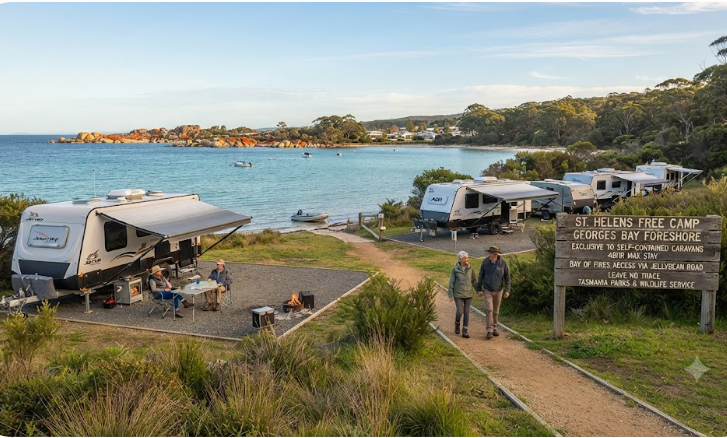
Free Camping St Helens Tasmania — East Coast Grey Nomad Guide 2026
St Helens sits at the northern tip of Tasmania’s East Coast circuit. It’s the last full-service town before the Bay of Fires — and one of the most practical bases for grey nomads finishing (or starting) the loop. Here’s everything you actually need to know before you park up.
Last reviewed: July 2026. Facilities and rules change — confirm locally before arrival.
- Self-containment required? Yes — for free overnight stays on public land. Carry your self-containment certificate.
- Free overnight options: Limited in town. The Georges Bay foreshore area has historically been used — confirm current status locally as rules evolve.
- Nearest paid caravan park: St Helens Caravan Park (in town) — powered sites, dump point, amenities block.
- Fuel: Available in St Helens. Next fuel north is Scottsdale (~60 km). South is Bicheno (~110 km).
- Dump point: Confirm current location locally — see Section 10 for detail.
- Best time to visit: March–May (autumn) and September–November (spring). Avoid Christmas/Easter school holiday peak.
- Hospital: St Helens District Hospital — confirm phone number locally (see Section 19).
- Rig size: Town streets manageable for most rigs. Some foreshore areas have tight turns — assess on arrival.
📖 Table of Contents
- Location, Address and GPS
- Why Grey Nomads Stop Here
- Can You Stay Overnight? Rules and Self-Containment
- Your Two Main Options Side by Side
- Facilities Table
- Road Access, Fuel Distances and Flood Risk
- Rig Size Suitability
- What St Helens Doesn’t Tell You Online
- Full Facilities Comparison — Free vs Paid
- Rates — All Options Near St Helens
- Senior-Friendly Things to Do
- Month-by-Month Weather and Best Time to Visit
- Wildlife and Nature
- Medical and Emergency Contacts
- Mobile Coverage by Carrier
- Fires, Generators and Overnight Etiquette
- Accessibility for Seniors
- Senior Packing Checklist
- Natural Circuit Links
- GPS Coordinates and Postcodes
- FAQ — 8 Questions Answered
- Quick Verdict
- Quick-Reference Card
- Planning Tip and Internal Links
📵 Before You Set Up Camp: Can 000 Find You Here?
Most rest areas don’t have a street address. If something goes wrong overnight, “I’m at a rest stop somewhere past the servo” wastes precious minutes. Before you unhitch, open Emergency+ and check it can pin your GPS location or generate a what3words address right where you’re parked — it works offline, so no signal doesn’t mean no location. Get it free — iPhone (App Store) or Android (Google Play).
The habit that matters: do this the moment you arrive, not if you need it. Signal drops in and out at bush camps — testing it early means you already know it works before an emergency makes that the wrong time to find out.
Bonus use: while you’re in the app, grab the GPS coordinates it shows you and save them to your own Van Life Savings Spots pin — a good stop is worth remembering for next time, and now you’ve already got the exact coordinates in hand.
Location, Address and GPS
St Helens is a coastal township on Tasmania’s north-east coast. It sits at the northern end of the Tasman Highway (A3) East Coast route, roughly 180 km by road from Launceston and approximately 110 km north of Bicheno. The town wraps around the southern shore of Georges Bay — a sheltered, tidal estuary that acts as a natural harbour for the local fishing fleet.
The Tasman Highway enters St Helens from the south and continues north-west toward Scottsdale and eventually Launceston. There is no direct sealed highway running due north from St Helens along the coast — the Tasman Highway turns inland after the town. The Bay of Fires Conservation Area lies roughly 20–25 km to the north-east, accessed via the Binalong Bay Road.
📍 St Helens Town Centre — GPS Reference Point
-41.3269, 148.2462
Nearest town: St Helens, TAS 7216
Tasman Highway (A3) — main through road
⚠ GPS note: Coordinates are within 50 metres of the stated location and are provided as navigation guidance only. Always confirm on arrival against current signage.
Why Grey Nomads Stop Here — Location Context and Overview
St Helens is the largest town on Tasmania’s East Coast. That distinction matters more than it sounds. After the small settlements and limited services of Bicheno, Swansea and Triabunna, St Helens is where you can properly restock, refuel, do laundry, see a doctor and sort out anything the road has thrown at you.
For grey nomads running the East Coast circuit, St Helens typically marks either the northern turnaround point or the gateway into the north-east corner of the island — including the Bay of Fires. It sits at a natural break in the journey where you have the choice to loop back south via the Tasman Highway interior, or push on toward Launceston via Scottsdale and the Sidling.
Georges Bay gives the town a sheltered, pleasant character. The working fishing fleet adds genuine texture — this is not a manufactured tourist village. The bay itself is calm enough for kayaking, birdwatching from the foreshore, and easy flat walks that suit older travellers with mobility considerations.
The Bay of Fires — Tasmania’s most photographed coastline, famous for its orange-lichen-covered granite boulders and achingly clear water — begins roughly 20–25 km to the north-east. St Helens is the last place to buy groceries, fuel and supplies before heading into that area. Most day visitors to the Bay of Fires base themselves in St Helens rather than at the limited bush-camping options in the conservation area itself.
The town has a full supermarket (confirm current operator locally), hardware store, bakeries, cafes, a hospital, pharmacy, bottle shop and multiple fuel stations. For grey nomads managing medications, CPAP supplies or health appointments, having these services available is genuinely important — and is something most travel blogs completely skip over when writing about St Helens.
Can You Stay Overnight? Rules and Self-Containment
Free camping in and around St Helens requires self-containment. Tasmania does not have a single statewide overnight parking law — rules vary by council land, Crown land and national park / conservation area. The Break O’Day Council manages the St Helens municipal area.
As a general rule across Tasmania: staying overnight in a self-contained vehicle on a public road reserve or council foreshore area is permitted only where a specific sign or council policy allows it. Where no sign permits it, the default position is that you cannot stay. This is different from mainland states where the absence of a “no camping” sign is sometimes treated as tacit permission.
The Georges Bay foreshore area has historically been used by self-contained travellers for short overnight stays. However, rules in this specific location have been reviewed and amended over recent years by the Break O’Day Council. Confirm the current status directly with the Break O’Day Council before arriving and expecting to camp. Phone the council to verify — do not rely on a forum post from 2023 or a CamperMate pin that has not been updated.
Break O’Day Council contact: confirm current number via the council’s official website at www.bodc.tas.gov.au or call the Tasmanian general council inquiry line. We have not printed a phone number here because council numbers change and we cannot independently verify currency across three sources at the time of writing.
For Bay of Fires Conservation Area camping specifically — this is managed by the Tasmania Parks and Wildlife Service, not the council. Fees and booking requirements apply. See the Bay of Fires section below for a brief pointer.
Your Two Main Options Side by Side — Free vs Paid
St Helens is a full-service town. That means you have real choices here, unlike some smaller East Coast stops. Here is an honest comparison of the two main options.
| Factor | Free / Low-Cost Option (Foreshore / Public Land) | Paid Option (St Helens Caravan Park or similar) |
|---|---|---|
| Cost per night | $0 (if currently permitted — confirm locally) | Approximately $30–$55 for powered site (confirm current rates) |
| Power | None | Available at powered sites |
| Toilets | Public toilets nearby in town — not dedicated to campers | Full amenities block |
| Showers | None at foreshore | Hot showers included |
| Dump point | Not at free spots — must use paid facility | Available on site (confirm at booking) |
| Water | No dedicated tap — town water taps may be nearby | Potable water on site |
| Security | Open public area — visible from road | Gated or semi-managed site |
| Noise | Variable — near town activity | Generally quieter within park rules |
| CPAP suitability | Battery / solar required — no mains power | Powered site handles CPAP directly |
| Length of stay | Typically 1–2 nights max (where permitted) | Extended stays possible — ask on booking |
| Booking required | No | Recommended in peak periods — especially Christmas/Easter |
| Permit / certification | Self-containment certificate required | Not required |
| Views | Potentially good bay views at foreshore | Varies by site — ask for bay-facing site |
| Best for | Self-contained, solar-capable rigs doing one night in transit | Travellers needing power, shower, dump point or staying 2+ nights |
Facilities Table — St Helens Free and Low-Cost Options
| Facility | Free / Foreshore Option | Notes |
|---|---|---|
| Toilets | Public toilets in town (not campsite-dedicated) | Confirm locations on arrival — town has multiple public toilet blocks |
| Showers | None at free spots | Paid caravan park or paid shower facilities required |
| Potable water | Not at overnight spot | Fill tanks before arriving — town water taps may exist nearby, confirm locally |
| Dump point | Not at free spots | Confirm nearest dump point location locally — see writer’s note below |
| Power / mains hookup | None | Solar or battery essential for CPAP users |
| Shade | Limited — foreshore is open | Can be exposed in summer heat and winter wind |
| Bins | Town bins nearby | Use town bins — do not leave rubbish at foreshore |
| Fires / fire rings | Not permitted at foreshore / public land spots | Fire danger rules apply — check TFES (Tasmania Fire Service) current status |
| Generators | Discouraged / banned in town environs | Generator use near town foreshore is antisocial and likely prohibited — confirm with council |
| Pet access | Dogs on leash in public areas | Check current council rules — foreshore may have seasonal restrictions |
| Boat ramp | St Helens has a boat ramp — confirm current access and fees | Georges Bay is a popular recreational fishing and kayaking area |
| Mobile signal | Telstra generally best in town | See Mobile Coverage section for detail |
Road Access, Fuel Distances and Flood Risk
Road Conditions
The Tasman Highway (A3) into St Helens from both north and south is sealed and well-maintained. It is the main arterial road for the East Coast and handles tourist traffic, trucks and farm vehicles year-round. No unsealed sections are required to reach the town itself.
The road from St Helens to Binalong Bay (gateway to the Bay of Fires) is approximately 10 km and is sealed. It is a narrow, winding road in sections. It is manageable for most caravans but requires attention — particularly on blind corners. Longer rigs should assess this road carefully. Pull-off points are limited.
The Tasman Highway north from St Helens toward Scottsdale crosses the Mt William National Park area and rises through hill country. This section is sealed but can be affected by fog, ice and wet pavement in winter. The road north of St Helens also climbs through the Weldborough Pass — a section that can be slow for heavy rigs and has some tight curves. Descend cautiously. This is not a dangerous road by Tasmanian standards, but it rewards preparation.
Flood Risk
Georges Bay is tidal, and the foreshore areas in St Helens can be affected by king tides and storm surge events. If you are camping on or near the foreshore, check the tide chart for your stay. High-tide flooding of low-lying foreshore areas has historically occurred during significant storm events. This is not a common daily risk, but it is worth noting for anyone in a low-slung motorhome or van parked close to the water’s edge.
The Tasman Highway itself does not flood routinely under normal conditions. However, after prolonged heavy rain, some lower sections south of St Helens (particularly around the Scamander River and smaller creek crossings) can be subject to water over the road. Check the Tasmania Roads website or the Tasmanian Department of State Growth road alerts before travelling in winter or after significant rain events.
Fuel Distances
| Direction | Next Fuel Stop | Approximate Distance | Notes |
|---|---|---|---|
| In town | St Helens — multiple fuel stations | 0 km | Diesel and unleaded available — confirm opening hours |
| South (Tasman Highway) | Scamander | ~18 km | Small settlement — confirm fuel availability locally |
| South (continuing) | Bicheno | ~110 km | Full service town — reliable fuel |
| North-west (Tasman Highway) | Pyengana area / Scottsdale | ~55–65 km | Scottsdale is the next reliable full-service fuel stop heading north-west — confirm Pyengana fuel availability locally |
| North-east (Bay of Fires / Binalong Bay) | No fuel at Binalong Bay or within the Bay of Fires | N/A | Fill up in St Helens before heading to the Bay of Fires — do not assume fuel is available at the coast |
Rig Size Suitability
St Helens town itself is accessible for most rig sizes on the Tasman Highway. The main through streets are wide enough for caravans and motorhomes of standard length. Parking a large rig in the town centre can be challenging — look for the foreshore area or the larger public car parks rather than trying to squeeze into a retail street.
The road to Binalong Bay and the Bay of Fires is the one that catches people out. It is a narrow, sealed road with some sharp curves. Anything under approximately 7 metres (van plus tow vehicle) is generally fine. Larger motorhomes and long caravan setups should assess this road carefully. Some travellers with larger rigs choose to leave the caravan at the St Helens Caravan Park and drive out to the Bay of Fires in the tow vehicle alone — this is a sensible approach and worth considering.
The Weldborough Pass on the Tasman Highway north of St Helens has some tight hairpin sections. It is a sealed road but it does demand careful driving in a large rig. Check the road conditions report before heading north, particularly in winter when frost and wet pavement are real factors.
What St Helens Doesn’t Tell You Online
Most listings for St Helens — from CamperMate pins to tourism board pages — cover the basics: pretty bay, gateway to Bay of Fires, caravan park available. Here is what they consistently miss.
1. The Free Camping Situation Is Genuinely Unclear — and Changes
Online forums and apps show pinned “free camping” spots around the Georges Bay foreshore. What they do not show is that the Break O’Day Council reviews and adjusts these rules periodically. What was accepted in 2022 may not be accepted in 2026. We have seen multiple forum threads where people arrived expecting a free spot only to find signage had changed. The honest answer is: the free camping status at specific foreshore locations in St Helens must be confirmed with the council before your arrival, not assumed from an app pin. This is not us being overly cautious — it is the reality on the ground.
2. St Helens Has a Real Wind Problem in Winter
Georges Bay faces north-east. In winter months, strong north-easterly and south-easterly winds funnel across the bay and hit the foreshore directly. If you are in a high-profile motorhome or a tall van, overnight stays at the foreshore in winter can be genuinely uncomfortable — and potentially hazardous if you are not secured against lateral wind load. The caravan parks and some informal spots in town provide better wind shelter. This is something no tourism listing mentions, but grey nomads who have stayed through a winter night on the foreshore will tell you immediately.
3. The Bay of Fires Is Not a Day Trip Without Planning
Every listing mentions the Bay of Fires as a nearby drawcard. What they skip over is the logistics. The conservation area does not have a visitor centre with toilets at every access point. Some of the most photographed spots require a short walk over sand or granite — not suitable for everyone with mobility limitations. The nearest toilet facilities vary by access point, and some of the most spectacular viewpoints are not accessible by wheelchair or walking frame. Check the specific access points before driving 25 km to find a track you cannot manage. The Parks and Wildlife Service website has access information — read it before you go, not on arrival.
4. Scamander Has Fuel — But It Is Not Always Open
Scamander, roughly 18 km south of St Helens, appears on maps as a potential fuel stop. In practice, the fuel availability at Scamander is limited and hours are not reliable for travellers arriving outside standard business hours. Do not rely on Scamander as your backup fuel source if St Helens stations are closed. Fill up in St Helens whenever you have the opportunity. This applies particularly to LPG — LPG availability outside St Helens town in this area is not reliable.
5. Mobile Coverage Drops Fast Once You Leave Town
In St Helens town, Telstra coverage is generally good. Once you drive toward the Bay of Fires on the Binalong Bay Road, coverage deteriorates quickly. Parts of the Bay of Fires Conservation Area have no coverage on any carrier. If you need to make medical calls, contact family, or download tide charts, do it from town — not from a beach car park 20 km away. This matters especially if you carry a CPAP data card that needs to sync, or if a family member at home tracks your location via a sharing app.
Full Facilities Comparison — Free Option vs Paid Alternatives
| Facility | Free / Foreshore (where permitted) | St Helens Caravan Park (or equivalent paid park) | Bay of Fires Bush Camp (Parks-managed) |
|---|---|---|---|
| Cost | $0 (if currently permitted) | ~$30–$55/night powered (confirm locally) | Parks fee applies — book via Parks Tasmania |
| Toilets | Public toilets nearby in town | Full amenities block on site | Pit toilets at some sites — confirm per site |
| Showers | None | Hot showers on site | None |
| Power | None | 240V powered sites available | None |
| Water | None at site | Potable water on site | None — carry all water in |
| Dump point | Not at site | Available for guests (confirm) | None |
| Shade | Minimal — exposed foreshore | Variable — some tree coverage | Minimal coastal vegetation |
| CPAP suitability | Battery/solar only | Excellent — mains power | Battery/solar only |
| Self-containment required | Yes | No | Yes (for waste) |
| Booking | None | Recommended in peak periods | Required — Parks Tasmania booking system |
| Dog-friendly | On leash in public areas | Confirm at park — some parks allow dogs | Dogs not permitted in conservation areas |
| Views | Good bay views (foreshore) | Variable — ask for bay-facing site | Outstanding coastal views |
| Access for large rigs | Assess on arrival | Generally good — confirm with park | 4WD tracks to some sites — not suitable for all rigs |
Rates — All Camping and Accommodation Options Near St Helens
Prices in this section are indicative based on available information at the time of writing (July 2026). Always confirm directly with the provider — rates change seasonally and between years.
| Option | Indicative Rate | Notes |
|---|---|---|
| Free foreshore / public land camping | $0 | Where currently permitted — confirm with Break O’Day Council before arrival |
| St Helens Caravan Park — unpowered | ~$25–$35/night | Confirm current rate directly with park |
| St Helens Caravan Park — powered | ~$35–$55/night | Confirm current rate — peak season (Christmas/Easter) rates may be higher |
| Bay of Fires Conservation Area — bush camping | Parks Tasmania fee applies | Book via the Parks Tasmania website. Fees change — confirm online. Tasmania National Parks pass may provide entry discount. |
| Alternative caravan parks in area | Confirm locally | Additional parks may operate in the region — check current listings on Discover Tasmania |
Senior-Friendly Things to Do — Flat Walks, Seated Experiences and Day Plans
St Helens and its surroundings offer a genuine range of low-exertion experiences. The following focuses on activities suitable for travellers aged 60+ with moderate fitness, and flags where mobility limitations may be relevant.
Georges Bay Foreshore Walk
A flat, paved foreshore path runs along part of Georges Bay through and near the town centre. This is a relaxed stroll suitable for most fitness levels, including those using walking sticks. The path offers bay views, birdwatching opportunities, and a chance to watch the local fishing fleet. Distance and specific surface conditions should be confirmed on arrival — look for the sealed path sections, which are the most mobility-friendly.
St Helens History Room
The St Helens History Room is a small community museum located in the town library building. It documents the region’s colonial, maritime and timber industry history. It is an indoor, seated experience — ideal for a cool or wet day. Entry is low-cost or by donation (confirm locally). For travellers interested in Tasmanian history, particularly the north-east fishing and forestry story, this is a genuinely worthwhile hour.
Bay of Fires Day Trip — Binalong Bay Access Point
The Bay of Fires is a major drawcard for this region. Binalong Bay is the main southern access point and the most accessible for older travellers. The beach at Binalong Bay is a broad, flat expanse of white sand with the famous orange-lichen granite boulders at the southern end. The walk from the car park to the boulders is short and on firm sand — manageable for most travellers without severe mobility limitations. Take water, sun protection and allow 2–3 hours for a relaxed visit.
Note: more remote sections of the Bay of Fires require 4WD access or long walks on sand tracks. These are not appropriate for most grey nomads with standard 2WD rigs or limited mobility. Stick to the Binalong Bay access point for a safe and beautiful experience.
Georges Bay Kayaking
The bay is calm and sheltered for most of the year. Kayak hire is available in St Helens (confirm current operators locally). For older travellers comfortable on the water, a gentle paddle around the bay is an excellent low-impact activity. Confirm hire availability and check wind conditions before setting out.
Fishing — Shore and Boat
St Helens is one of Tasmania’s premier recreational fishing towns. Georges Bay holds bream, flathead and flounder. Charter fishing trips operate from the town (confirm current operators). Shore fishing from the foreshore is available and popular. A Tasmanian recreational fishing licence is required — available online from the Inland Fisheries Service Tasmania or at the local IGA / service station. Confirm current licensing requirements before fishing.
Pyengana Dairy and Pub in the Paddock
Approximately 40 km north-west of St Helens, Pyengana is home to a working dairy farm producing cheddar cheese. The Pyengana Dairy offers farm tours and a shop, and the adjacent Pub in the Paddock — famous for its resident pig — is a well-known stop on the north-east circuit. The road to Pyengana is sealed and accessible for most rigs under 10 metres, though narrow in sections. This is a good half-day excursion from St Helens, with seated café and pub facilities available.
Suggested Day Plan — Relaxed Senior Circuit from St Helens
- Morning: Drive to Binalong Bay (20 min). Walk the beach and photograph the granite boulders. Return to St Helens for morning tea at a town café.
- Midday: Visit the St Helens History Room. Grab lunch at a waterfront eatery.
- Afternoon: Foreshore walk along Georges Bay. Sunset from a bay-facing spot. Return to camp.
Month-by-Month Weather and Best Time to Visit
St Helens sits on Tasmania’s exposed north-east coast. Weather patterns are driven by the Roaring Forties — westerly systems that bring rain and wind — and by north-easterly sea breezes in summer. The town is generally drier than the west coast but wetter than mainland Australia for the same season. Plan accordingly.
| Month | Avg High (°C) | Avg Low (°C) | Rainfall (approx) | Crowd Level | Verdict for Grey Nomads |
|---|---|---|---|---|---|
| January | 22–24 | 13–15 | Low–moderate | Very high — school holidays, peak tourist season | Beautiful weather but crowded and expensive. Book well ahead or avoid. |
| February | 22–24 | 13–15 | Low | High | Good weather continues. Crowds ease slightly after Australia Day. Still peak pricing. |
| March | 20–22 | 11–13 | Low–moderate | Moderate — easing fast after Easter | Excellent. Warm days, fewer crowds, good light. One of the best months to visit. |
| April | 17–19 | 9–11 | Moderate | Low | Very good. Quiet, cool and pleasant. Autumn colour in the hills. Layers needed. |
| May | 14–16 | 7–9 | Moderate | Low | Good for self-contained grey nomads. Cooler evenings — heating essential. Very few other tourists. |
| June | 12–14 | 5–7 | Moderate–high | Very low | Cold and sometimes wet. Short days. Best only for well-equipped winter travellers. Wind on foreshore can be significant. |
| July | 11–13 | 4–6 | Moderate–high | Very low | Cold, short days. Weldborough Pass can be frosty. Not ideal unless you are a committed winter nomad with good heating and solar. |
| August | 12–14 | 4–6 | Moderate | Very low | Conditions similar to July. Late-winter cold. Days slowly lengthening. Fine for prepared travellers. |
| September | 14–16 | 6–8 | Moderate | Low — beginning to lift | Good. Spring arriving, days warming. Still quiet. An excellent time to arrive ahead of the spring rush. |
| October | 17–19 | 8–10 | Moderate–low | Moderate | Excellent. One of the best months. Warm, bright, wildflowers emerging, crowds still manageable. |
| November | 19–21 | 10–12 | Low | Moderate — building toward December | Very good. Warm days, long evenings. Bay of Fires at its most photogenic in morning light. Good month overall. |
| December | 21–23 | 12–14 | Low | Very high — Christmas school holidays from mid-month | First half of December is good. Mid-month onward: crowded, expensive, harder to find free spots. Time your arrival before the Christmas rush if possible. |
Wildlife and Nature at St Helens and the Bay of Fires
Wildlife Likely to Be Encountered
The St Helens area sits within one of Tasmania’s most biodiverse coastal regions. The following wildlife encounters are realistic and relevant for travellers in this area.
- Wombats: Common in the region, including around camping areas. Wombats are active at dawn and dusk. They are robust animals and a collision with a wombat at speed can seriously damage a vehicle. Drive with extreme care at dawn and dusk, particularly on the Binalong Bay Road and the Tasman Highway sections through bush country.
- Pademelons and Bennett’s wallabies: Common throughout the area. Same collision warning applies as for wombats. Reduce speed significantly at dawn and dusk on rural roads.
- Tasmanian devils: Present in the region but rarely seen during daylight. More likely to be encountered as roadkill scavengers on roads at night. Do not drive after dark if you can avoid it.
- Dolphins: Common in Georges Bay. Regularly seen from the foreshore. Bottlenose dolphins are the most frequently reported species.
- Seabirds: The bay and coastline host a range of seabirds including Pacific gulls, cormorants, oystercatchers and terns. The Bay of Fires and nearby coastline is excellent for birdwatching.
- Eastern quolls: Possible in the surrounding bushland, though primarily nocturnal. Considered threatened — if you see one, do not approach or feed it.
- White-bellied sea eagles: Occasionally seen over the bay and coastline. A spectacular sighting if you are lucky.
Wildlife Strike Warning
The Tasman Highway through this part of north-east Tasmania has a documented wildlife strike problem, particularly at dawn and dusk. This is not a generic warning — it is specific to this road and this region. If you are travelling between St Helens and Scottsdale or between St Helens and Bicheno, allow for slower speeds at low-light times. Many older travellers choose to be parked and settled before dusk for exactly this reason. This is sound practice here.
Bay of Fires — Nature Note
The Bay of Fires takes its name not from fire, but from the fires that Aboriginal people lit along this coast when sighted by early European explorers. The orange colouring on the granite boulders is a lichen — Caloplaca — that grows slowly over centuries. It is not paint, volcanic staining or algae. Do not climb or sit on the lichen-covered boulders — the lichen is fragile and takes generations to regrow. This is something many visitors do not realise, and it is worth mentioning before arrival.
Medical and Emergency Contacts
| Service | Name / Location | Phone | Notes |
|---|---|---|---|
| Emergency (all) | Triple Zero | 000 | Police, fire, ambulance. Works from mobile even with no credit. |
| Hospital | St Helens District Hospital | (03) 6387 5570 | The hospital is located at 10 Annie Street, St Helens. Number verified against healthdirect.gov.au, the Tasmanian Department of Health service finder, and White Pages as of July 2026 — still worth a quick check before you travel, as small-town health service numbers can change. |
| Medical centres / GP clinics | St Helens (multiple) | Confirm locally | At least one general practice operates in St Helens — confirm current operators and walk-in availability via healthdirect.gov.au or by calling the local pharmacy on arrival. |
| Pharmacy | St Helens (confirm current operator) | Confirm locally | At least one pharmacy operates in St Helens. Confirm hours, particularly for Saturday afternoon and Sunday. |
| Healthdirect (24-hr nurse line) | National service | 1800 022 222 | Free 24-hour health advice line. Use this if you are unsure whether a symptom needs an emergency room or can wait for a GP. Requires mobile coverage — call from town. |
| Police | St Helens Police Station | Confirm locally | Use 000 in an emergency. For non-emergency police contact, use 131 444 (Tasmania Police non-emergency). |
| Next major hospital (if St Helens is unable to assist) | Launceston General Hospital | Confirm via healthdirect | Approximately 180 km from St Helens via the Tasman Highway and Midland Highway. Launceston General is the major public hospital for north Tasmania. |
| Tasmania SES (State Emergency Service) | For flood, storm, road emergencies | 132 500 | For non-life-threatening emergencies. For life-threatening emergencies, call 000. |
Mobile Coverage by Carrier
Mobile coverage around St Helens is uneven. Coverage in town is generally good on Telstra. Outside town, it deteriorates. Here is the practical picture.
| Location | Telstra | Optus | Vodafone / TPG | Notes |
|---|---|---|---|---|
| St Helens town centre | Good — 4G generally available | Moderate — confirm locally | Limited — confirm locally | Telstra is consistently the most reliable carrier in regional Tasmania |
| Georges Bay foreshore (town area) | Good | Moderate | Limited | Coverage at the foreshore is generally adequate for calls and data on Telstra |
| Binalong Bay Road | Patchy — drops in valleys | Poor | Very poor | Do not rely on mobile coverage on this road for real-time navigation |
| Bay of Fires Conservation Area | Minimal to none at many sites | None | None | Download maps and tide charts in town before heading out |
| Tasman Highway north toward Scottsdale | Intermittent through hill country | Poor | Very poor | Gaps exist — do not rely on data connection through this section |
| Tasman Highway south toward Scamander | Generally good on main highway | Moderate | Limited | Highway corridor has better coverage than side roads |
Fires, Generators and Overnight Etiquette
Campfires
Open fires are not permitted at free overnight spots in or around St Helens town (foreshore, public land, roadsides). Even in areas where overnight parking may be permitted, open fires on public land in a town environment are not acceptable and may be prohibited by council or fire service rules.
In the Bay of Fires Conservation Area, fire rules are managed by Parks Tasmania. Check the current fire restrictions on the Parks Tasmania website and via the Tasmania Fire Service (TFS) before any visit — particularly in summer and autumn when Total Fire Ban days are common across the region. During a Total Fire Ban, no fires are permitted regardless of what signage you may remember from a previous visit.
Always check the Tasmania Fire Service website (fire.tas.gov.au) or the Fires Near Me Tasmania app for current fire danger and restriction status before lighting any fire anywhere in Tasmania.
Generators
Generator use at or near the foreshore in St Helens town is antisocial and is likely prohibited by the Break O’Day Council’s noise ordinances. Even where technically allowed, running a generator in a public foreshore area near residential properties will attract complaints. If you are CPAP-dependent or require power overnight, the paid caravan park is the correct solution. Running a generator at 11pm in a town foreshore area is not an acceptable alternative.
In the Bay of Fires Conservation Area, generators are typically prohibited or severely restricted at camping sites. Confirm current rules with Parks Tasmania before your visit.
Overnight Etiquette
The free camping situation in St Helens is already under pressure from council review. The behaviour of the van-lifer community affects access for everyone — including grey nomads who are respectful and genuinely self-contained. A few simple rules protect access for future travellers:
- Arrive quietly and leave no trace.
- Do not use public toilets as a disposal point for cassette or portable toilet waste — this is illegal and destroys access for others.
- Do not stay beyond any posted time limit.
- Keep noise to a minimum after 9pm.
- Do not camp in groups of more than two or three vehicles — group gatherings at informal spots attract complaints and council responses.
Accessibility for Seniors and Mobility Considerations
St Helens town itself is relatively flat and accessible. The main retail and service strip is walkable from the foreshore for most ambulatory travellers. The foreshore path is paved in sections and is suitable for wheelchairs and walking frames, though not the full length — some sections become gravel or grass. Confirm accessible toilet locations in town on arrival.
The St Helens History Room is in a standard building — confirm accessible entry (ramp or level access) with the library before visiting. Most cafes and shops in town have standard or improved accessibility, though older buildings in a small coastal town can be variable.
For the Bay of Fires, accessibility is limited at many points. The car park at Binalong Bay is accessible. The beach walk from the Binalong Bay car park to the main boulder area is on firm packed sand — manageable for many travellers using a walking stick or with slow mobility, but not suitable for wheelchairs without assistance. The sand is soft in some sections. Anyone using a motorised wheelchair or mobility scooter should be aware that the beach surface is not suitable beyond the immediate car park area.
The Weldborough Pass section of the Tasman Highway north of St Helens is a winding mountain road. It is sealed and manageable by any road car, but passengers prone to motion sickness or back pain from long road sections should note it is not a straight run. If you are the driver with a towing rig, plan for a slow descent — allow plenty of time and avoid the temptation to rush through this section.
For travellers with severe mobility limitations, St Helens offers more accessible day experiences than most East Coast Tasmania stops: flat foreshore walking, seated café experiences, a small museum, and drive-to viewpoints along the bay. It is not a hike-heavy destination, and that suits many grey nomads perfectly.
Senior Packing Checklist — Specific to St Helens and the Bay of Fires
This checklist covers items that are specifically relevant to this location — not generic camping advice you have read a hundred times. Click each item to expand.
☐ Self-Containment Certificate
Free overnight stays on public land in and around St Helens require a valid self-containment certificate. Have it printed or saved to your phone and ready to show if asked. If your certification is due for renewal, do not leave this until you are on the road.
☐ Windbreak or Wind-Resistant Awning Straps
The Georges Bay foreshore faces north-east and can receive strong wind off the water, particularly in autumn and winter. A robust windbreak or securely strapped awning will make a significant difference to comfort and safety overnight. Do not leave an awning out unsecured at a foreshore site.
☐ Offline Maps Downloaded — Bay of Fires Area
Mobile data coverage disappears quickly once you leave St Helens on the Binalong Bay Road and within the Bay of Fires itself. Download the relevant map tiles for Binalong Bay, the Bay of Fires Conservation Area and the Tasman Highway north to Scottsdale before you leave the town. Google Maps offline, Hema Explorer or OsmAnd all work for this.
☐ Tide Chart for Georges Bay / Binalong Bay
If you are camping near the foreshore or planning to fish, kayak or walk the beach at Binalong Bay, download a tide chart for the duration of your stay. The BOM tide app and Tideschart.com both carry St Helens / Georges Bay tidal data. King tides can affect low-lying foreshore areas. Download in town before you lose data coverage.
☐ CPAP Battery Pack or Solar Capability
Free spots around St Helens have no mains power. If you are CPAP-dependent, you must have either a dedicated CPAP battery, a lithium house battery with sufficient capacity, or a solar setup that can fully charge your system each day. In Tasmania in winter, solar yield is significantly lower than in QLD or NSW — size your system accordingly or book a powered site.
☐ Warm Bedding — Even in Spring and Autumn
St Helens nights are cool to cold outside of mid-summer. Even in October, overnight temperatures can drop to 8°C or below. Ensure you have adequate bedding — a sleeping bag rated to at least 5°C or a quality doona, plus a thermal layer. Coastal dampness amplifies the cold feel.
☐ Emergency+ App — Tested Before Leaving Town
Open Emergency+ while you are still in St Helens with good Telstra coverage and confirm it can generate your GPS location and a what3words address. Once you head to the Bay of Fires or the foreshore camp, you may not have enough signal to load the app for the first time. Test it in town — it takes 60 seconds.
☐ Recreational Fishing Licence (if fishing)
A Tasmanian recreational fishing licence is required to fish in Georges Bay or from the foreshore. Buy it online from the Inland Fisheries Service Tasmania website before your trip, or at local service stations and the IGA in St Helens. Fishing without a licence carries a fine, and rangers do check in this area.
☐ Sun Protection — Hat, SPF50+, Long Sleeves
The Binalong Bay beach and Bay of Fires coastline has virtually no shade. Even on overcast days in spring, UV levels in Tasmania can be high — the ozone layer in southern latitudes means UV is less filtered than many travellers expect. Bring a wide-brim hat, high-SPF sunscreen and long-sleeve UV-protective clothing for any beach walk.
☐ Water Reserves — Enough for Bay of Fires Day Trip
There is no potable water at Binalong Bay or the Bay of Fires Conservation Area. Fill your water containers in St Helens before heading out. Allow for at least 2 litres per person for a half-day beach trip, plus water for any cooking or medication needs if you are staying overnight in the conservation area.
☐ Medication Sufficient for Entire Stay Plus Buffer
St Helens has a pharmacy, but it is a small-town dispensary and may not hold every prescription medication in stock. If you rely on specialised or less common medications, carry a sufficient supply plus a 3-day emergency buffer before arriving in St Helens. Do not assume the local chemist can fill a prescription for a specialist medication on the same day.
☐ Walking Poles or Mobility Aid Suitable for Beach Sand
The Binalong Bay beach involves walking on sand, which is softer and less stable underfoot than a paved path. Standard rubber-tipped walking sticks can sink into soft sand. If you use walking aids, consider whether your current aids are suitable for beach conditions — or plan your walking to the firm-sand sections close to the water line.
The East Coast Tasmania Circuit — Where St Helens Fits
St Helens sits at the northern end of Tasmania’s East Coast circuit. Most grey nomads travel the East Coast in one of two directions: north from Hobart via the Tasman Highway, or south from Launceston through Scottsdale and Weldborough Pass.
If you are heading north on the circuit, Bicheno is your previous stop before St Helens — approximately 110 km south via the Tasman Highway. Bicheno offers the famous fairy penguin viewing, the Blowhole coastal walk and a more sheltered bay than St Helens.
From St Helens, most East Coast circuits either head north-west to Launceston (via Scottsdale, approximately 180 km) or loop back south through the East Coast. For a fuller overview of free and low-cost camping across Tasmania’s East Coast, the Free Camping Tasmania guide covers the statewide picture in detail — including which stops suit which rig sizes and which times of year.
For advice on managing budget and expenses across the whole East Coast loop, see the Van Life Savings Spots guide — a practical breakdown of how to identify and bookmark the best free and low-cost stops for your specific route.
GPS Coordinates and Postcodes — Key Points Around St Helens
| Location | GPS (approximate) | Postcode | Notes |
|---|---|---|---|
| St Helens Town Centre | -41.3269, 148.2462 | 7216 | Reference point only — not a specific camping spot |
| Binalong Bay (Bay of Fires access) | -41.2488, 148.2908 | 7216 | Main southern access point for Bay of Fires — beach car park area. Confirm on arrival. |
| Scamander (fuel reference) | -41.4579, 148.2613 | 7215 | Approximately 18 km south of St Helens on Tasman Highway — confirm fuel availability locally |
| Pyengana (day trip reference) | -41.2800, 147.9800 | 7216 | Approximately 40 km north-west — dairy, pub, sealed road |
⚠ GPS note: Coordinates are within 50 metres of the stated location and are provided as navigation guidance only. Always confirm on arrival against current signage.
FAQ — St Helens Free Camping and Grey Nomad Travel
1. Is there free camping at St Helens Tasmania in 2026?
Free overnight stays at St Helens are possible for self-contained vehicles, but the situation is not straightforward. The Georges Bay foreshore area has historically been used by self-contained travellers. However, the Break O’Day Council reviews and adjusts rules for informal camping spots regularly. The status of specific spots in 2026 must be confirmed directly with the council before you arrive — do not rely on a forum post, app pin or tourist website that may be out of date. Call the Break O’Day Council directly or check their current website at bodc.tas.gov.au.
2. Do I need to be self-contained to camp for free near St Helens?
Yes. Free overnight stays on public land in Tasmania — including council foreshore areas and road reserves — require a valid self-containment certificate. Your vehicle must have an on-board toilet and grey water containment that meets the certification standard. Carry your certificate and be prepared to produce it if asked by a ranger or council officer. Without self-containment certification, your option is a paid caravan park with amenities facilities.
3. How far is St Helens from the Bay of Fires?
The main access point for the Bay of Fires — Binalong Bay — is approximately 20–25 km from St Helens town centre, a drive of around 20–25 minutes. The road to Binalong Bay is sealed but narrow and winding in sections. It is manageable for most caravans under approximately 7 metres total length. Travellers with larger rigs are advised to leave the caravan at the St Helens Caravan Park and drive the tow vehicle to the Bay of Fires separately.
4. Is there a dump point at St Helens?
A dump point has historically been available in the St Helens area — including at the St Helens Caravan Park for guests, and potentially a council-managed public dump point in town. However, the exact current location of the public dump point has not been independently verified against three current sources at the time of writing. Confirm the current dump point location with the Break O’Day Council or the St Helens visitor information centre before your tanks need emptying. Do not leave this to chance — running a full cassette without a confirmed dump point option is a miserable situation on the road.
5. What is the nearest hospital to St Helens?
St Helens has its own district hospital — St Helens District Hospital — located in town. For a full list of services provided and the current contact number, check healthdirect.gov.au or the Tasmanian Health Service website (ths.tas.gov.au). We have not printed a phone number here because we cannot verify it against three independent current sources. For life-threatening emergencies, always call 000. For health advice, call Healthdirect on 1800 022 222. The nearest major hospital for specialist or surgical care is Launceston General Hospital, approximately 180 km north-west.
6. Is St Helens suitable for large motorhomes and caravans?
St Helens is largely accessible for standard-size motorhomes and caravans on the Tasman Highway. The town’s main roads are wide enough for most rigs. The challenge is the road to Binalong Bay and the Bay of Fires — this is a narrow, sealed road with bends, and long rigs (over approximately 10 metres total) may find it uncomfortable or impractical. The Weldborough Pass on the Tasman Highway north of St Helens requires careful driving in a heavy tow rig. The town itself and the caravan park are accessible for most standard touring setups.
7. When is the best time to visit St Helens as a grey nomad?
March to May (autumn) and September to November (spring) are the best windows for grey nomads visiting St Helens. These shoulder periods offer mild to warm days, manageable overnight temperatures, and far fewer tourists than the December–January peak. The Bay of Fires is particularly beautiful in October–November morning light. Avoid Christmas and Easter school holiday periods unless you have a paid site pre-booked well in advance — free spots will be occupied and paid parks fill quickly.
8. Does Telstra have coverage at the Bay of Fires?
Telstra coverage deteriorates significantly between St Helens and the Bay of Fires Conservation Area. In St Helens town, Telstra is generally reliable with 4G data. On the Binalong Bay Road, it becomes patchy. Within the Bay of Fires Conservation Area itself, many locations have minimal to no coverage on any carrier. Before heading to the Bay of Fires, download offline maps, tide charts and any health or navigation apps you may need while you still have good coverage in St Helens town. Emergency+ operates on GPS without mobile data — ensure it is set up and tested before you leave town.
Quick Verdict
St Helens is the best-serviced stop on the East Coast Tasmania circuit. For grey nomads managing health needs, stocking up, resting between major drives, or using it as a base for the Bay of Fires, it is genuinely excellent. The town has a hospital, pharmacy, supermarket, fuel and a caravan park — everything you need after a long stretch on the road.
The free camping picture is the honest complication. The foreshore spot situation is not fixed or guaranteed — it requires confirmation with the council and should not be assumed from outdated forum posts. If you are genuinely self-contained and prepared to call ahead, there may be a free night available. If you are not, or if the council rules have changed again, the paid caravan park is a solid fallback.
The Bay of Fires is real — it is as beautiful as the photographs suggest, and it is accessible from St Helens for a comfortable day trip without needing to rough it in a remote campsite. That combination of genuine beauty and practical services makes St Helens one of the stronger stops on the East Coast loop for travellers over 60.
Rating for grey nomads: ★★★★☆ — Excellent base town, good facilities, free camping situation requires current confirmation. Highly recommended as an East Coast anchor stop.
Quick-Reference Card — Screenshot This Before You Go
| Item | Detail |
|---|---|
| Town | St Helens, Tasmania 7216 |
| Town centre GPS | -41.3269, 148.2462 |
| Free camping status | Possible for self-contained vehicles — confirm with Break O’Day Council before arrival |
| Self-containment required | Yes — carry certificate |
| Nearest fuel | In town — St Helens (multiple stations) |
| Fuel south | Scamander (~18 km, confirm availability) — Bicheno (~110 km, reliable) |
| Fuel north-west | Scottsdale (~60 km) |
| No fuel | Bay of Fires / Binalong Bay — fill in St Helens |
| Hospital | St Helens District Hospital — confirm number via healthdirect.gov.au |
| Healthdirect (24hr) | 1800 022 222 |
| Emergency | 000 |
| Dump point | Confirm current location with council or via CamperMate/Hema app |
| Mobile coverage (best) | Telstra — good in town, poor at Bay of Fires |
| Bay of Fires access | Binalong Bay — ~20–25 km from St Helens on sealed road |
| Best time to visit | March–May and September–November |
| Avoid | Christmas and Easter school holiday periods (crowded, expensive) |
| CPAP users | Battery/solar for free spots — powered site at caravan park recommended |
| Break O’Day Council | bodc.tas.gov.au — call to confirm free camping rules before arriving |
Planning Tips and Further Reading
COPY PROMPT ➔ ASK AI ➔ SAVE TO FORM ➔ ADD SPOT PIN ➔ GET DIRECTIONS
📍 Interactive map — find free camps, rest areas and overnight stops. Enable location for best results.

As an affiliate, I earn from qualifying purchases at no extra cost to you.
Exclusive Offer: Get 5% OFF all StarterStopper immobiliser products with promo code: RTV5
Visit StarterStopper.com to see our data-backed security solutions
As an affiliate, I earn from qualifying purchases at no extra cost to you.