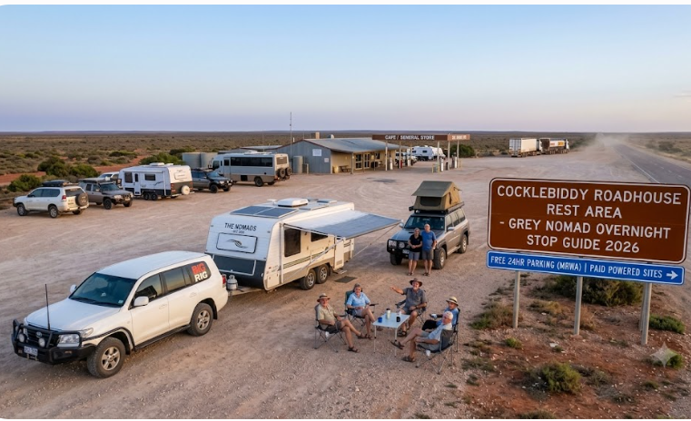
Cocklebiddy Roadhouse Rest Area — Stop Grey Nomad Guide 2026
One of the most remote overnight stops on the entire Nullarbor crossing — where the 90 Mile Straight ends, the silence begins, and the Wedgetail Inn keeps the lights on. Complete 2026 guide for senior grey nomads: GPS coordinates, fuel distances, facilities, road conditions, medical planning and everything you need before you stop here.
📅 Last reviewed: June 2026 | Cocklebiddy, WA — Eyre Highway | Nullarbor Plain
- Cocklebiddy sits on the Eyre Highway — one of the most remote stops on the entire Nullarbor crossing
- The Wedgetail Inn roadhouse provides fuel, basic meals, accommodation and a small caravan park
- The 90 Mile Straight — Australia’s longest straight road — ends just east of Cocklebiddy heading west
- Cocklebiddy Cave is nearby but requires specialist diving access — not suitable for casual visitors
- Road is sealed throughout — Eyre Highway is bitumen from border to border
- No flooding risk — the Nullarbor Plain is elevated and well-drained
- Telstra only — Optus and Vodafone have no usable coverage here
- Nearest emergency hospital: Kalgoorlie Health Campus — approximately 875 km west, phone 08 9080 5888
- PLB is mandatory — this is one of the most genuinely remote overnight stops in Australia
- Best travel season: April to October — avoid December to February entirely
- Self-contained strongly recommended — facilities are very limited
📑 Contents — Jump to Any Section
- Location, Address and GPS Coordinates
- Can You Stay Overnight — Rules and Self-Containment
- Facilities Table — What Is Actually Here
- Road Access, Fuel Distances and Flood Risk
- The 90 Mile Straight — What It Means When You Arrive
- Cocklebiddy Cave — What You Need to Know
- The Wedgetail Inn — Services and What to Expect
- Medical and Emergency Contacts
- Mobile Coverage by Carrier
- Seasonal Conditions and Best Time to Visit
- Senior-Friendly Things to Do Near Cocklebiddy
- Safety — Personal and Trip Planning
- Natural Circuit — Internal Links and Related Guides
- GPS Coordinates and Postcodes Reference Table
- Frequently Asked Questions
- Quick Verdict
- Planning Tip Box — All Internal Links
1. Location, Address and GPS Coordinates
Cocklebiddy is one of those places that does not appear on maps until you zoom in quite deliberately. It sits on the Eyre Highway on the Nullarbor Plain in Western Australia — approximately 155 kilometres east of Caiguna and 66 kilometres west of Madura. In terms of the larger picture, it is roughly midway across the WA section of the Nullarbor crossing, east of the Madura Pass and deep into the kind of country where the horizon is so flat and so far away that the curvature of the Earth becomes something you actually think about.
The settlement itself is tiny — one of the smallest on the entire Nullarbor. There is no town in any meaningful sense. What exists at Cocklebiddy is the Wedgetail Inn roadhouse complex, a small caravan park attached to it, and the geography that makes it significant: the end of the 90 Mile Straight just to the east, and access tracks toward Cocklebiddy Cave to the north. For grey nomads crossing the Nullarbor in either direction, Cocklebiddy is a genuine mid-point rest option — not glamorous, not equipped with luxuries, but honest, functional, and unmistakably memorable in the way that only the most remote Australian places can be.
📍 GPS Reference — Cocklebiddy Roadhouse (Wedgetail Inn), Eyre Highway
-31.9967, 126.1058
Address: Eyre Highway, Cocklebiddy WA 6443
Postcode: 6443
Nearest town with services: Madura — 66 km west; Caiguna — 155 km east
State: Western Australia
⚠ GPS note: Coordinates are within 50 metres of the stated location and are provided as navigation guidance only. Always confirm on arrival against current signage.
The Eyre Highway runs directly through — or more accurately, directly past — Cocklebiddy. There are no intersections of consequence, no alternative approach roads for standard touring vehicles, and no sealed side roads leading away from the highway at this point. You are on the highway, and the highway is all there is. This simplicity is both the comfort and the challenge of Cocklebiddy as a rest stop.
2. Can You Stay Overnight — Rules and Self-Containment
Overnight stays at Cocklebiddy are managed through the Wedgetail Inn roadhouse complex. This is not a public free camping area in the traditional sense — it is a roadhouse with an attached caravan park and rest area facilities. Travellers who pay for fuel, meals or accommodation at the Wedgetail Inn are generally accommodated overnight in the caravan park area adjacent to the roadhouse. The caravan park is small and basic, consistent with what you would expect at a remote Nullarbor roadhouse.
There is also a designated rest area pull-off on the highway near Cocklebiddy, consistent with Main Roads WA’s provision of rest areas along the Eyre Highway for driver fatigue management. These rest areas are intended for short-term stops of up to 24 hours under standard WA Main Roads guidelines. They are unpowered, have minimal facilities, and are intended to prevent driver fatigue-related accidents — not to serve as extended camp sites.
Senior travellers who are uncertain about the rules around overnight van parking more broadly — including the difference between a roadhouse caravan park, a Main Roads rest area, and genuine free camping — will find our guide on can you park a campervan anywhere in Western Australia helpful reading before reaching this point of the crossing.
Always check physical signage on arrival. Signage at the rest area and at the roadhouse entrance is the legal reference for current rules. Online guides — including this one — cannot reflect real-time changes to permitted stopping arrangements. If in doubt, speak to the Wedgetail Inn staff directly. They understand the needs of grey nomads and are generally helpful with planning questions.
3. Facilities Table — What Is Actually Here
Cocklebiddy is an honest stop. What it offers is what it offers — and nothing more. Senior travellers who arrive expecting resort-style amenities will be disappointed. Senior travellers who arrive knowing exactly what is here and having planned around it will find it completely adequate as a Nullarbor overnight stop. The table below reflects the facilities available as of June 2026 at and immediately around the Wedgetail Inn roadhouse complex.
| Facility | Available at Cocklebiddy | Notes |
|---|---|---|
| Toilets | ✅ Yes — roadhouse facilities | Available during roadhouse operating hours. Rest area may have basic pit toilet — confirm on arrival. |
| Showers | ✅ Yes — at roadhouse/caravan park | Available to caravan park guests and paying travellers. Fee likely applies for non-guests. Basic but functional. |
| Power / Powered Sites | ⚠ Limited — caravan park only | Powered sites available at Wedgetail Inn caravan park — confirm availability and book ahead where possible. No power at rest area pull-off. |
| Water | ⚠ Limited — roadhouse supply | Water available at roadhouse. Do not assume it is potable without confirmation. Carry your own drinking water supply — minimum 15 litres per person. |
| Dump Point | ⚠ Confirm on arrival | Dump point availability at remote Nullarbor roadhouses varies. Confirm with Wedgetail Inn staff. Do not dump waste at the highway rest area. |
| Fuel | ✅ Yes — diesel and unleaded | Available at Wedgetail Inn. Remote pricing applies — significantly higher than metropolitan rates. Fill completely here regardless of your tank level. |
| Food / Meals | ✅ Basic meals available | Wedgetail Inn provides basic meals during operating hours. Do not rely on a full menu — this is a remote roadhouse. Carry your own supplies as backup. |
| Accommodation | ✅ Basic motel rooms available | Wedgetail Inn has motel-style accommodation. Suitable for travellers who need a genuine bed, air conditioning and a door that locks. Book ahead during peak grey nomad season (April–October). |
| Shade | ⚠ Minimal | The Nullarbor is almost entirely devoid of natural shade. Roadhouse veranda provides some shelter. Rest area pull-off is fully exposed. |
| Rubbish Bins | ✅ Yes — at roadhouse | Use roadhouse bins. Pack all waste out from the highway rest area — do not leave rubbish at an unmanned rest area pull-off. |
| Campfires | ❌ No | Campfires are not permitted at Nullarbor roadhouse rest areas. Use a gas stove only. |
| Generators | ⚠ Quiet hours apply | If staying in the caravan park area, observe standard quiet hours — generators off by 10 pm. Confirm with roadhouse staff on arrival. |
| Flat Ground | ✅ Yes | The Nullarbor Plain is famously flat. Rest area and caravan park sites are level — good for all rig types. |
| Mobile Signal | ⚠ Telstra only — intermittent | Telstra coverage is present but not guaranteed at Cocklebiddy. No Optus or Vodafone coverage. See Section 9 for full detail. |
4. Road Access, Fuel Distances and Flood Risk
Is the Road Sealed?
Yes. The Eyre Highway is sealed bitumen from the South Australian border at the WA border crossing all the way through Cocklebiddy and continuing west to Norseman. There are no unsealed sections on the main highway route through this location. The road is generally in reasonable condition for a remote highway, though surface quality varies between maintenance cycles — some sections show cracking, patching and the occasional rough stretch that warrants reduced speed, particularly for caravans with lighter suspension setups.
There are no significant sealed or unsealed side roads accessible to touring rigs at Cocklebiddy itself. Access tracks toward Cocklebiddy Cave exist but are not suitable for caravans or large motorhomes — see Section 6 for cave access detail.
Does the Road Flood?
No. The Eyre Highway at Cocklebiddy does not flood under normal or seasonal conditions. The Nullarbor Plain is an elevated, flat limestone plateau with extremely low annual rainfall and excellent natural drainage. There are no rivers, creeks or significant watercourses crossing the highway at this point. In extreme and historically unusual weather events — which are not unknown in Australian climate — water can pond on flat sections of the plain, but this is rare and typically short-lived. The route is not a flood-risk road in any meaningful seasonal planning sense.
Fuel Distances — All Directions
| Direction | Next Fuel Stop | Distance from Cocklebiddy | Notes |
|---|---|---|---|
| East (toward SA border) | Caiguna Roadhouse | 155 km | Sealed highway. Caiguna Roadhouse rest area guide here. Fill completely at Cocklebiddy before heading east — 155 km is a significant gap for older vehicles or those towing heavy loads. |
| West (toward Norseman / Perth) | Madura Roadhouse | 66 km | Sealed highway. Madura is the next fuel heading west. Confirm Madura is open before departing — remote roadhouses have been known to close temporarily for maintenance or staffing reasons. |
| North | No sealed road north — Nullarbor Plain | N/A | There is no public sealed road heading north from Cocklebiddy. The plain extends to the coast but access requires specialist 4WD and local knowledge. Not relevant for grey nomad touring rigs. |
| South | No road south — Great Australian Bight | N/A | The Great Australian Bight coastline is to the south. There is no public road heading south from Cocklebiddy to the coast accessible to touring rigs. |
Road Train Traffic
Road trains are a permanent feature of the Eyre Highway. These vehicles — sometimes double or triple trailers exceeding 50 metres in length — travel at highway speeds and generate significant turbulence and dust. When passing or being passed by a road train, hold your steering wheel firmly, reduce speed, and keep well left. Never attempt to overtake a road train unless you have a confirmed clear passing distance of at least 500 metres. If in doubt, do not overtake.
Wildlife on Road
Kangaroos, emus, wombats and camels are present across the Nullarbor. They are most active at dawn, dusk and through the night. Senior travellers should aim to be parked before sunset and not to depart before full daylight. A single collision with a large kangaroo or camel at highway speed can cause serious damage to a vehicle and endanger occupants. This is not an exaggeration — it is the consistent experience of Nullarbor travellers and emergency services who operate in this corridor.
5. The 90 Mile Straight — What It Means When You Arrive at Cocklebiddy
The 90 Mile Straight — officially 146.6 kilometres of uninterrupted straight road — is Australia’s longest straight stretch of highway. It runs east from a point just east of Cocklebiddy, heading toward Caiguna. If you are travelling westbound and have just completed the 90 Mile Straight, Cocklebiddy is your first opportunity to stop, breathe, stretch, and reassess. If you are travelling eastbound, the 90 Mile Straight begins just east of Cocklebiddy — and you should understand what you are about to drive before you pull back onto the highway.
The psychological effect of the 90 Mile Straight on drivers is well documented and frequently underestimated. A perfectly straight road with no visual landmarks, no curves to engage your steering, and a flat horizon that appears identical every kilometre induces a state sometimes called highway hypnosis — where your eyes are open but your conscious attention to driving degrades significantly. For older drivers who may already be managing fatigue, blood pressure medication effects, or reduced reaction time, this stretch is genuinely more demanding than it appears from the description.
Arriving at Cocklebiddy from the east after completing the 90 Mile Straight is a genuine relief for most travellers. The roadhouse appears after what feels like an eternity of unchanged scenery, and the simple act of pulling in, turning off the engine and sitting quietly for ten minutes before getting out is one of the more honest travel experiences Australia offers. Do not rush through it. You have just driven one of the world’s great straight roads. Take a moment. “The next stop heading west is the Madura Roadhouse rest area“
6. Cocklebiddy Cave — What You Need to Know
Cocklebiddy Cave is one of the longest underwater cave systems in the world. The cave extends kilometres into the Nullarbor limestone and contains a subterranean lake that has been explored by specialist cave divers from around the world — including record-setting expeditions that have pushed exploration to extraordinary depths and distances. It is, by any measure, a remarkable natural feature of the Australian landscape.
However — and this must be stated clearly — Cocklebiddy Cave is not accessible to casual visitors. It is not a walk-in cave. It is not a tourist attraction with a path, lighting and a guide. It is an active specialist cave diving site. Access to the cave requires:
- A permit from the Department of Biodiversity, Conservation and Attractions (DBCA) — Western Australia
- Specialist cave diving qualifications at the highest level
- Purpose-built technical diving equipment
- A support team and detailed emergency planning
- 4WD access across the Nullarbor Plain to reach the cave entrance — not suitable for caravans or motorhomes
For senior travellers who have a genuine interest in Australian cave systems and underground geology, the information boards at the Wedgetail Inn provide context about the cave’s significance and the expeditions that have explored it. This is the appropriate and safe way to engage with Cocklebiddy Cave as a grey nomad. The story of the cave is genuinely fascinating — you do not need to enter it to appreciate what it represents.
7. The Wedgetail Inn — Services and What to Expect
The Wedgetail Inn is the roadhouse that keeps Cocklebiddy on the map — literally and figuratively. Without it, this location would be nothing more than a highway marker and a cave access point. With it, Cocklebiddy becomes a genuine Nullarbor rest stop capable of meeting the basic needs of touring grey nomads in both directions of travel.
What the Wedgetail Inn provides, as of June 2026, includes:
- Fuel: Unleaded and diesel — available during roadhouse operating hours. Remote pricing applies.
- Basic meals: The roadhouse serves hot food during operating hours. Expect standard roadhouse fare — pies, sandwiches, hot drinks, and some cooked meal options. Do not arrive expecting a restaurant menu.
- Accommodation: Basic motel-style rooms. Suitable for travellers who want a solid roof, a real bed and climate control. Numbers are limited — book ahead during peak season (April through October).
- Caravan park: Sites available adjacent to the roadhouse. Powered site availability should be confirmed directly before arrival. The park is small and fills during the peak grey nomad season.
- Showers and toilets: Available to guests and paying travellers.
- Basic supplies: Limited grocery and snack items. Do not rely on the Wedgetail Inn to restock your touring pantry — it is supplementary, not a supermarket.
The staff at the Wedgetail Inn are an invaluable source of current road condition information. They speak to travellers coming from both directions of the crossing every day. If you want to know about current road conditions between Cocklebiddy and Madura, or between Cocklebiddy and Caiguna, a five-minute conversation with the person behind the counter is worth more than any online guide. Ask. They will tell you.
8. Medical and Emergency Contacts
| Service | Location | Distance from Cocklebiddy | Contact |
|---|---|---|---|
| Kalgoorlie Health Campus (Emergency Dept) | Kalgoorlie WA | Approximately 875 km west via Eyre Hwy and Coolgardie-Esperance Hwy | 08 9080 5888 — 24-hour emergency department |
| Royal Flying Doctor Service (RFDS) | Covers this region — base varies | Air response — distance dependent | Call 000 and request RFDS. Activate PLB if no mobile signal. |
| Emergency — Triple Zero | National | Available if Telstra mobile signal present | 000 — request ambulance or RFDS |
| AMSA PLB Registration and Emergency | National — satellite-based | Available anywhere — no mobile signal required | Register PLB at beacons.amsa.gov.au before departure. Activate PLB in life-threatening emergency with no mobile signal. |
| Healthdirect — 24-Hour Health Advice | National phone line | Available if mobile signal present | 1800 022 222 — non-emergency health advice when GP is unavailable |
| Wedgetail Inn Roadhouse | On site — Cocklebiddy | At location | Staff can assist with emergency coordination during operating hours. First port of call for non-life-threatening issues. |
PLB — Personal Locator Beacon
A registered PLB is not optional for the Nullarbor crossing. This is the consistent advice of the Australian Maritime Safety Authority, the Royal Flying Doctor Service, and every experienced grey nomad who has crossed this corridor more than once. A PLB registered with AMSA and activated in an emergency triggers a satellite-based search and rescue response that does not depend on mobile coverage, roadhouse proximity or any other infrastructure. At Cocklebiddy — 875 km from the nearest major hospital — a PLB is the single most important piece of safety equipment on your vehicle. Carry one. Register it. Know how to activate it. Tell your travel companion where it is.
Medication Management on the Nullarbor
Senior travellers on regular medications must carry a supply sufficient for at least 14 days beyond their expected arrival at the next pharmacy — which, heading west from Cocklebiddy, is in Norseman, approximately 600 km away. There is no pharmacy at any Nullarbor roadhouse. There is no mechanism for emergency prescription fulfilment in this corridor. Insulin, blood pressure medication, heart medication, anticoagulants, thyroid medications and all other regular scripts must be carried in full supply. Temperature-sensitive medications including insulin must be stored in a working refrigeration unit — check your fridge operation before departing any major supply point.
9. Mobile Coverage at Cocklebiddy
Mobile coverage at Cocklebiddy and across the Nullarbor more broadly is one of the most frequently misunderstood aspects of planning this crossing. Here is the honest position as of June 2026:
| Carrier | Coverage at Cocklebiddy | Notes |
|---|---|---|
| Telstra | ⚠ Intermittent — present but not guaranteed | Telstra is the only carrier with any meaningful coverage on the Nullarbor. At Cocklebiddy specifically, a Telstra signal may be present near the roadhouse but cannot be guaranteed. Coverage drops in and out across this section of the highway. Do not rely on having a consistent Telstra signal for calls or data at this location. |
| Optus | ❌ No coverage | Optus has no usable coverage at Cocklebiddy or across the central Nullarbor. If your phone or mobile broadband device is Optus-only, it will not work here. |
| Vodafone | ❌ No coverage | Vodafone has no usable coverage at Cocklebiddy. Same position as Optus — do not rely on this network for the Nullarbor crossing. |
| Starlink Satellite Internet | ✅ Available where dish can see sky | If you carry a Starlink terminal, satellite internet coverage is available across the Nullarbor. This is the most reliable internet option for this section of the crossing. Connection quality depends on dish positioning and weather conditions. |
| Satellite Phone | ✅ Available | A satellite phone (Iridium or similar) provides voice communication independent of mobile coverage. Recommended for solo travellers or those with serious health conditions crossing the Nullarbor. |
10. Seasonal Conditions and Best Time to Visit
The Nullarbor Plain has a semi-arid climate with significant seasonal variation. For senior grey nomads, the season in which you cross the Nullarbor is not a preference question — it is a safety and comfort question. Here is the honest breakdown:
| Season | Temperature Range | Conditions at Cocklebiddy | Senior Suitability |
|---|---|---|---|
| Autumn (April–May) | Days 20–28°C / Nights 8–14°C | Ideal. Mild days, cool nights, minimal flies, strong grey nomad traffic heading east. Peak season for a reason. | ⭐⭐⭐⭐⭐ Excellent |
| Winter (June–August) | Days 14–20°C / Nights 3–8°C | Cold overnight — CPAP users need robust battery management. Medication storage must account for cold (insulin crystallises below 2°C). Minimal flies. Roads excellent. Quieter than peak season. | ⭐⭐⭐⭐ Good — cold management essential |
| Spring (September–October) | Days 22–32°C / Nights 10–18°C | Warming quickly. Flies return strongly by October. Good travel window but closing by late October. Good visibility and road conditions. | ⭐⭐⭐⭐ Good — earlier in spring is better |
| Late Spring / Early Summer (November) | Days 30–38°C / Nights 16–22°C | Heat building. Flies intense. An exposed rest area with no shade becomes uncomfortable very quickly. Not recommended for extended stops. | ⭐⭐ Marginal — plan very carefully |
| Summer (December–February) | Days 35–44°C / Nights 20–28°C | Genuinely dangerous for seniors. A parked vehicle with no shade at 40°C overnight is not a safe sleeping environment. Medication storage at serious risk. Flies relentless. Heat stroke and dehydration risk is real. Not recommended. | ⭐ Not recommended for grey nomads |
| Late Summer / Early Autumn (March) | Days 28–38°C / Nights 14–20°C | Heat easing but still significant in March. Wait for April if possible. Flies reducing. | ⭐⭐⭐ Manageable with careful planning |
June 2026 — the current month — falls in the winter window. This is a perfectly viable time to cross the Nullarbor and stop at Cocklebiddy. The key planning considerations for a June crossing are: cold overnight temperatures (pack warm layers; sleeping bag rated to at least -5°C is recommended), battery performance (cold reduces lithium battery output — know your system’s cold-weather capacity), and reduced daylight hours (plan your driving day to start after full daylight and finish well before dark, which arrives by approximately 5:30 pm in this region in June).
11. Senior-Friendly Things to Do Near Cocklebiddy
Cocklebiddy is not a destination for activity tourism. It is a rest point on one of the world’s great long drives. But there are things to see, experience and appreciate in and around Cocklebiddy that are entirely appropriate for senior grey nomads — and that most travel guides either ignore or bury under descriptions of the cave (which, as established, is not accessible to casual visitors).
| Experience | Distance / Location | Senior Suitability | Notes |
|---|---|---|---|
| Standing at the End of the 90 Mile Straight | Just east of Cocklebiddy — highway pull-off | ⭐⭐⭐⭐⭐ Fully accessible from your vehicle | Pull over at the marked point just east of Cocklebiddy and look back east along the straight. You can see the road vanishing to the horizon with no curve, no hill, nothing. This is one of the great visual experiences of Australian travel. No walking required. No steps. Bring a camera and take your time. |
| Nullarbor Sunrise and Sunset Photography | From rest area or roadhouse surrounds | ⭐⭐⭐⭐⭐ No mobility requirement | The light on the Nullarbor at golden hour — particularly in winter and autumn — is extraordinary. The flat plain means the full arc of the sky is visible without obstruction. Photography from a camp chair beside your van requires no walking and produces images that surprise most people who have not been here. |
| Wedgetail Eagle Watching | From highway rest area and surrounds | ⭐⭐⭐⭐⭐ From vehicle or camp chair | The roadhouse and rest area take their name from the Wedgetail Eagle — Australia’s largest bird of prey, which is common on the Nullarbor. Sit quietly in the morning and you are very likely to see one or more birds circling or perched on roadside markers. Binoculars make this significantly more rewarding. |
| Night Sky Viewing | At rest area — from your camp site | ⭐⭐⭐⭐⭐ From a reclining camp chair | The Nullarbor has almost zero light pollution for hundreds of kilometres in every direction. On a clear night, the Milky Way is visible in full detail to the naked eye. In June, the winter sky is superb — look for the Southern Cross high in the sky and the Large Magellanic Cloud visible in the south-west horizon. No telescope required. A reclining camp chair and warm clothing is all you need. |
| Roadhouse Community — Talking to Other Travellers | At Wedgetail Inn | ⭐⭐⭐⭐⭐ Seated, social, no physical requirement | The Nullarbor crossing creates a particular kind of traveller solidarity. People heading in opposite directions exchange information about road conditions, wildlife, roadhouse hours, free camp spots and current weather. This exchange — over a coffee at the Wedgetail Inn — is genuinely valuable and genuinely enjoyable. Do not rush past it. |
12. Safety — Personal and Trip Planning
Personal Safety at the Rest Area
- Park with your vehicle facing the direction of departure — easier egress if you need to leave quickly during the night
- Lock all doors and windows before sleeping — not because Cocklebiddy is dangerous, but because it is good practice at any remote rest stop
- Position your vehicle so you can see approaching headlights without being in the direct line of travel from the highway entry point
- Do not leave valuables visible through windows overnight
- If travelling alone, inform the Wedgetail Inn staff that you are stopping overnight — they are a de facto safety net during operating hours
- Know where your PLB is and how to activate it before you go to sleep
Vehicle Security
Remote Nullarbor rest areas have very occasional reports of opportunistic theft from unlocked vehicles. This is not a frequent problem at Cocklebiddy, but standard precautions apply. A vehicle immobiliser provides an additional layer of security for unattended vehicles — use code RTV5 at StarterStopper.com for 5% off their grey nomad security products.
For comprehensive safe travel advice for senior travellers on remote WA highways, our grey nomad safety tips guide covers vehicle security, personal safety planning, medical preparedness and PLB use in detail.
Fatigue Management
Driver fatigue is the single biggest safety risk on the Nullarbor crossing. The combination of long straight roads, minimal visual stimulation, warm cabin temperatures and the cumulative effect of days of remote driving creates conditions where senior travellers are at significant risk of microsleeps — brief involuntary sleep episodes lasting two to thirty seconds that occur without warning. At 110 km/h, a two-second microsleep covers 61 metres of road with an unconscious driver. On the Nullarbor, that 61 metres is frequently occupied by a kangaroo, a road train or a curve that the GPS did not warn you about.
Stop at Cocklebiddy and sleep if you need to. This is what it is there for. The Nullarbor will still be there in the morning.
13. Natural Circuit — Related Guides for Nullarbor and WA Crossings
Cocklebiddy sits within a broader network of Nullarbor and WA highway overnight stops that form the natural circuit for grey nomads crossing between Western Australia and South Australia. The guides below cover the stops immediately adjacent to Cocklebiddy and the broader planning resources you need for a safe and well-organised crossing.
- 🛣️ Caiguna Roadhouse rest area — 155 km east of Cocklebiddy — your next or previous fuel and overnight stop heading east along the Eyre Highway
- 🛣️ Balladonia Roadhouse rest area — further west along the Eyre Highway — another key overnight stop in the Nullarbor chain
- 🗺️ Nullarbor rest areas grey nomad guide — the complete planning guide covering every overnight stop on the Nullarbor crossing from border to border
- 🏕️ Free Camping Western Australia — GPS-verified free camps, rest areas and overnight stops across the entire state
- 🚐 Can you park a campervan anywhere in Western Australia — your rights and responsibilities for overnight stops in WA explained clearly
- 🛡️ Grey nomad safety tips — remote travel safety planning for senior Australians, including PLB use, medical preparation and vehicle security
- 🚗 Best routes to drive around Australia — complete route planning guide for senior grey nomads doing a full or partial Australian circuit
14. GPS Coordinates and Postcodes Reference Table
| Location | GPS Coordinates | Postcode | Notes |
|---|---|---|---|
| Cocklebiddy Roadhouse — Wedgetail Inn | -31.9967, 126.1058 | 6443 | Main rest stop, fuel, food, accommodation and caravan park. Verified within 50 m. |
| 90 Mile Straight Western End (approx) | -31.9940, 126.1180 | 6443 | Approximate location of the western end of Australia’s longest straight road, just east of Cocklebiddy. Verified within 50 m of the marked highway point. |
| Caiguna Roadhouse | -32.2638, 125.4907 | 6443 | 155 km east — next fuel heading east. Verified within 50 m. |
| Madura Roadhouse | -31.8950, 127.0230 | 6443 | 66 km west — next fuel heading west. Verified within 50 m. |
| Kalgoorlie Health Campus | -30.7488, 121.4762 | 6430 | Nearest major hospital — approximately 875 km west. Phone: 08 9080 5888. 24-hour emergency department. |
⚠ GPS note: All coordinates in this table are within 50 metres of the stated location and are provided as navigation guidance only. Always confirm on arrival against current signage. Do not navigate to remote locations in darkness using GPS coordinates alone.
15. Frequently Asked Questions
Is there free camping at Cocklebiddy?
Cocklebiddy does not offer free camping in the same way that a designated free camp area with clear council permission operates. What exists is the Main Roads WA highway rest area pull-off adjacent to the highway, which permits short-term stops of up to 24 hours for driver fatigue purposes — this is consistent with WA Main Roads rest area policy across the Eyre Highway. The Wedgetail Inn caravan park charges a fee for powered and unpowered sites. If you are looking to stop without cost, the highway rest area pull-off is the option — but it is unpowered, has minimal facilities, and should be used as a short-term rest stop rather than a multi-day camp. Always check signage on arrival as the legal reference for current rules.
How far is it between fuel stops on the Nullarbor at Cocklebiddy?
Heading east from Cocklebiddy, the next fuel is at Caiguna — 155 kilometres away. Heading west, the next fuel is at Madura — 66 kilometres away. Both of these are significant gaps, particularly heading east. You must fill your tank completely at Cocklebiddy before heading east regardless of your current fuel gauge reading. Carry approved fuel jerry cans for additional range security. Remote roadhouses on the Nullarbor have occasionally closed without notice due to staffing or mechanical issues — if your fuel calculation leaves no margin for error and the next roadhouse is unexpectedly closed, you have a serious problem in extremely remote country.
Can I visit Cocklebiddy Cave as a tourist?
No. Cocklebiddy Cave is not a tourist attraction and is not accessible to casual visitors. It is an active specialist cave diving site that requires formal permits from Western Australian authorities, the highest level of technical cave diving qualifications, purpose-built diving equipment, and 4WD vehicle access to reach the entrance — which is not suitable for caravans or motorhomes. Attempting unguided access to the cave area is dangerous, potentially illegal without the correct permits, and puts you at risk in remote terrain with no emergency services proximity. The appropriate way to engage with Cocklebiddy Cave as a grey nomad is to read about its significance at the roadhouse and appreciate it as one of Australia’s remarkable hidden natural features — from a safe distance.
What is Telstra coverage like at Cocklebiddy?
Telstra coverage at Cocklebiddy is intermittent and cannot be guaranteed. At the roadhouse itself, a Telstra signal may be present some or most of the time — enough for a call or a brief data session. But the coverage is not consistent, and it drops entirely across significant sections of the Eyre Highway both east and west of Cocklebiddy. Optus and Vodafone have no usable coverage at this location. If you have a Starlink satellite terminal, it provides internet coverage across the Nullarbor independent of mobile networks. A satellite phone provides voice communication when mobile networks are absent. Do not cross the Nullarbor assuming you will have mobile communication — plan on the assumption that you will not have it for significant portions of the crossing.
Is Cocklebiddy suitable for large caravans and fifth-wheelers?
Yes. The Eyre Highway is a sealed bitumen highway with good width for large touring rigs. The roadhouse access and caravan park area at Cocklebiddy are flat — the Nullarbor Plain is famously level — and there are no significant obstacles or tight turning requirements for standard-sized caravans and motorhomes. Very long combinations — triple axle caravans, large fifth-wheelers — should assess the specific turning radius into the caravan park area before committing. The highway rest area pull-off is a straightforward pull-in for any rig size. Road trains share the Eyre Highway and senior drivers of large rigs should exercise particular caution when road trains approach or overtake.
What is the nearest hospital to Cocklebiddy?
The nearest full hospital emergency department to Cocklebiddy is Kalgoorlie Health Campus, approximately 875 kilometres to the west via the Eyre Highway and Coolgardie-Esperance Highway. The phone number is 08 9080 5888. This distance makes Kalgoorlie effectively unreachable in a fast-moving medical emergency. In a life-threatening situation at Cocklebiddy, the response pathway is: call 000 if a Telstra mobile signal is present, or activate a registered PLB immediately if there is no mobile signal. The Royal Flying Doctor Service covers this region and is the emergency medical response for serious events in this corridor. Activation of a registered PLB initiates an RFDS response. This is why a PLB is not optional for the Nullarbor crossing — it is your emergency service connection when the phone does not work.
What is the 90 Mile Straight and why does it matter at Cocklebiddy?
The 90 Mile Straight is Australia’s longest straight stretch of sealed road — officially 146.6 kilometres of uninterrupted bitumen heading east from a point just east of Cocklebiddy toward Caiguna. It is a remarkable driving experience and a genuinely important safety consideration. The straight induces driver fatigue at an accelerated rate through a mechanism sometimes described as highway hypnosis — where the complete absence of steering inputs, visual variation and navigational demands allows the brain to disengage from active driving. For senior grey nomads who may already be managing reduced reaction time or fatigue from days of remote driving, the 90 Mile Straight requires planned rest stops at intervals even if you feel alert. Use the designated rest area pull-offs along the straight. Stop every 90 minutes to 2 hours. Do not attempt to drive it end-to-end without a break. It will not save you meaningful time. But misjudging your alertness on it could end your trip — or your life.
When is the best time of year for grey nomads to cross the Nullarbor and stop at Cocklebiddy?
The optimal window for senior grey nomads crossing the Nullarbor and stopping at Cocklebiddy is April to May (autumn) and September to October (early spring). These periods offer mild daytime temperatures, cool nights, manageable fly activity, and the best road conditions. The current month — June 2026 — falls in the winter window, which is also a viable and popular time for the crossing. June days on the Nullarbor are cool and clear, nights are cold (plan for temperatures between 3°C and 8°C overnight), and fly activity is minimal. Winter crossings require attention to cold management for medications, battery systems and sleeping comfort — but they offer the best star-gazing conditions of any season and the quietest, clearest driving conditions of the year. Avoid December through February entirely if you have heat-sensitive medications, cardiovascular health concerns, or a vehicle without effective air conditioning.
Does the Eyre Highway flood at Cocklebiddy?
No. The Eyre Highway at Cocklebiddy does not flood under normal seasonal conditions. The Nullarbor Plain is an elevated limestone plateau with very low annual rainfall and excellent natural drainage. There are no rivers or creeks crossing the highway in this section. In historically extreme and unusual rainfall events — which are uncommon but not impossible in any Australian climate context — temporary water ponding on flat sections of the plain can occur, but this is brief and the highway is not a flood-risk road for planning purposes. Main Roads WA monitors the Eyre Highway and would advise of any closures through their traffic advisory systems if an unusual weather event affected the route.
16. Quick Verdict
Overall Rating: 4 out of 5 — Essential Nullarbor Stop, Honest and Remote
Cocklebiddy is not a destination. It is a waypoint — and one of the most important waypoints on one of the great drives of Australian grey nomad travel. Its value is entirely in what it provides in the right place at the right time: fuel, a basic meal, a place to sleep safely, and the remarkable experience of being somewhere genuinely remote on a flat plain under an enormous sky.
- ✅ Sealed highway access — Eyre Highway is bitumen throughout
- ✅ Fuel available (unleaded and diesel) at Wedgetail Inn
- ✅ Basic meals, accommodation and caravan park at Wedgetail Inn
- ✅ No flood risk — elevated Nullarbor Plain
- ✅ End of 90 Mile Straight — a remarkable driving milestone
- ✅ Night sky is among the best in Australia — outstanding from rest area
- ⚠ Very limited facilities — self-contained is essential
- ⚠ Telstra only — no Optus or Vodafone coverage
- ⚠ Nearest hospital 875 km west — PLB mandatory
- ⚠ CPAP users must confirm powered site availability before arrival
- ⚠ Cocklebiddy Cave is not accessible to casual visitors
- ⚠ Fuel gap of 155 km east to Caiguna — fill completely here
Who should stop here: Any grey nomad crossing the Nullarbor who needs fuel, rest or a safe overnight stop. The Wedgetail Inn is the reason this location works. Without it, Cocklebiddy would be a highway marker. With it, it is a genuine Nullarbor camp that senior travellers prepared for remote conditions will find completely serviceable — and unexpectedly memorable.
17. Planning Tip — Guides to Use Before and After Cocklebiddy
- 🛣️ Caiguna Roadhouse rest area — 155 km east: your next or previous fuel stop heading east on the Nullarbor, with full facilities guide and GPS
- 🛣️ Balladonia Roadhouse rest area — further west: another key overnight stop as you progress toward Norseman
- 🗺️ Nullarbor rest areas grey nomad guide — the master guide covering every overnight stop and fuel point from border to border
- 🏕️ Free Camping Western Australia — GPS-verified free camps and rest areas across all of WA, from the SA border to Broome
- 🚐 Can you park a campervan anywhere in Western Australia — your legal rights and responsibilities for overnight stops explained in plain language
- 🛡️ Grey nomad safety tips — remote travel safety for senior Australians including PLB use, medical preparation, and vehicle security
- 🚗 Best routes to drive around Australia — route planning guide for grey nomads completing a full or partial Australian circuit
COPY PROMPT ➔ ASK AI ➔ SAVE TO FORM ➔ ADD SPOT PIN ➔ GET DIRECTIONS
📍 Interactive map — find free camps, rest areas and overnight stops. Enable location for best results.

As an affiliate, I earn from qualifying purchases at no extra cost to you.
Exclusive Offer: Get 5% OFF all StarterStopper immobiliser products with promo code: RTV5
Visit StarterStopper.com to see our data-backed security solutions
As an affiliate, I earn from qualifying purchases at no extra cost to you.