• North Star Road Rest Area Free Camping Guide 2026

    North Star Road Rest Area 2026 guide for senior grey nomads near Boggabilla NSW. Includes GPS, nearby water, dump point, toilets, safety, phone coverage, Wi-Fi and medical information

    North Star Road Rest Area — Free Camping Guide 2026 for Senior Grey Nomads

    North Star Road Rest Area is a simple overnight stop near Boggabilla in northern New South Wales that can suit senior grey nomads needing a lawful rest break before or after the Queensland border. If you are travelling the inland route and connecting toward the best routes to drive around Australia for grey nomads, this guide covers the practical details that matter most: verified GPS, what facilities are usually available, where to get water and dump points nearby, mobile coverage expectations, safety notes, and medical backup planning.

    At a glance

    Camp: Free roadside rest area / overnight stop
    Name: North Star Road Rest Area
    Area: Near Boggabilla, NSW 2409
    GPS: -28.6020, 150.3390
    Coordinate source: Publicly available map listings for North Star Road Rest Area / Boggabilla district roadside rest stop
    Best use: One-night rest break, lunch stop, driver fatigue stop
    Not a full campground: Bring your own water, toilet paper, and backup power

    North Star Road Rest Area at a glance

    Field Details
    Name North Star Road Rest Area
    Address North Star Road, near Boggabilla NSW 2409, Australia
    GPS -28.6020, 150.3390
    Coordinate source Publicly available map coordinates for the roadside rest area location near North Star Road / Boggabilla district. Always confirm with your map app and roadside signage on arrival.
    Cost Free
    Best for Overnight fatigue stop, short rest break, budget overnight while in transit
    Nearby public Wi-Fi Likely nearest public options are in Goondiwindi QLD 4390 via library, visitor information, major fast-food outlets or some caravan parks/town services. Check locally as availability changes.
    Warning: Rest area rules can change. Overnighting depends on current signage, local road authority rules, and any temporary closures. Do not rely on old app comments alone.

    North Star Road Rest Area GPS, address and map notes

    The most important safety detail for this stop is the location itself: North Star Road Rest Area, North Star Road, near Boggabilla NSW 2409, GPS -28.6020, 150.3390. For senior travellers, especially anyone towing a caravan, using the exact decimal coordinates matters more than using only the place name because similar roadside stops can appear in map searches.

    Practical tip: Save -28.6020, 150.3390 into your device and also store it offline in your van life savings spots planning notes before mobile coverage drops.

    Because this is a rest area rather than a staffed caravan park, there is no reception office, no booking desk and no one to call if you miss the turn. That is why GPS accuracy matters far more here than it does in a town caravan park.

    Is North Star Road Rest Area free to camp overnight?

    North Star Road Rest Area is generally used as a free overnight roadside rest area, designed for fatigue management and short-stay stopovers rather than extended camping. In practical terms, that means most travellers use it for a single night while moving through the district.

    There is normally no booking system and no fee. It is typically first come, first served.

    Important: Check the signs at the entrance when you arrive. If a stay limit is posted, follow that limit exactly. If “no camping” or “rest area only” wording appears, obey the sign even if old online reviews say otherwise.

    For travellers trying to reduce costs, this kind of stop can work well as part of a larger route plan. If you are mixing free camps and occasional paid nights, these guides may also help: living in a camper and how long can you stay in a caravan park in Australia.

    North Star Road Rest Area facilities: toilets, water, bins and dump point

    Facilities at North Star Road Rest Area are limited. This is where many websites are too vague. A senior traveller needs to know not just what might be there, but what to assume if nothing is working.

    Facility What to assume
    Toilets A basic public toilet may be available at some roadside stops in this corridor, but always carry your own toilet paper, hand sanitiser and torch. Do not assume servicing has been recent.
    Potable water Assume no drinking water at the rest area unless clearly signed potable.
    Dump point Assume no dump point on site.
    Showers No public showers expected.
    Power No powered sites.
    Bins May be limited. Carry rubbish out if bins are full.
    What other sites often leave out: Even where a toilet exists, it may be dark at night, slippery after rain, low-stocked for paper, or awkward for seniors with balance issues. Keep a head torch, slip-on shoes and sanitiser by the van door.

    How to get to North Star Road Rest Area

    North Star Road Rest Area is reached from the Boggabilla district road network, close to the NSW–Queensland border region. Most grey nomads will approach it either from Goondiwindi QLD or from inland New South Wales routes running toward Moree, Warialda or North Star.

    Approaching from Goondiwindi

    From Goondiwindi QLD 4390, follow the cross-border road connection toward Boggabilla and continue carefully using your GPS. This is the easiest supply town before or after the stop.

    Approaching with a caravan

    Slow down well before turning in. Road shoulders and entry angles can feel tighter with a van than they look on satellite view. Arriving in daylight is the safer option for seniors.

    Best arrival strategy: Try to arrive between 2 pm and 4 pm. You avoid both the late lunch exodus and the just-before-dark rush when fatigue stops fill quickly.

    What to expect on arrival at North Star Road Rest Area

    Expect a basic roadside stop, not a scenic destination campground. Surface conditions may vary from compacted gravel to worn dirt sections. Shade can be limited. Some spaces may suit self-contained caravans and motorhomes better than low-clearance rigs.

    In practical senior-travel terms, the first five minutes should be used for these checks:

    • Look for official stay-limit signs.
    • Check the ground before committing to a site, especially if rain has passed through.
    • Choose a level spot that does not require a long night walk to the toilet.
    • Park so you can leave easily in the morning without reversing into traffic flow.
    • Avoid isolated far corners if you are travelling solo.

    North Star Road Rest Area safety for senior grey nomads

    For most travellers, the main risks here are not crime. They are fatigue, trips and falls, dehydration, poor night visibility, and driving on after dark when you should have stopped earlier.

    Risk Why it matters for seniors What to do
    Uneven ground Trip hazard at night Use a torch, wear enclosed shoes, avoid walking after dark unless necessary
    Heat Border region days can still be hot well into autumn and spring Carry extra water and cool the van before sleep
    Night traffic noise Can disturb sleep and increase stress Park as far from through-traffic as practical
    Poor lighting Makes toilet trips harder Keep torch, glasses, keys and phone in one known spot
    Pet movement / wildlife Can cause slips or sudden braking Keep dogs leashed and do not walk them near moving vehicles at dusk
    Security reality check: Most Australian rest areas are used by decent travellers, but there is no manager, no reception and no formal security patrol. Lock your vehicle, keep valuables out of sight, and read our guide on how caravan theft happens in Australia for grey nomads.

    Medical and emergency information near North Star Road Rest Area

    Because this is a small roadside stop, your emergency planning should be based on nearby towns rather than the rest area itself.

    Service Address GPS Notes
    Goondiwindi Hospital 10 McLean Street, Goondiwindi QLD 4390 -28.5487, 150.3076 Nearest major practical hospital option for this border area
    Boggabilla Health Service Merriwa Street, Boggabilla NSW 2409 -28.6048, 150.3577 Useful local medical point, but not a substitute for a full regional hospital

    For emergencies, call 000. If you have significant medical issues, tell someone your overnight location before stopping.

    Senior travel tip: If you use blood pressure medication, insulin, anticoagulants or a CPAP machine, keep that gear where it can be reached fast at night without climbing over bedding or storage tubs.

    Phone signal and nearby public Wi-Fi

    Mobile coverage near border rest areas can be variable. Around Boggabilla and Goondiwindi, Telstra generally gives the best chance of usable coverage, but signal strength at the actual rest area may still fluctuate.

    Optus and Vodafone users should not assume reliable service at the exact overnight stop.

    Connectivity item Likely situation
    Telstra mobile Best chance of coverage in the district, but still not guaranteed at full strength
    Optus / Vodafone Can be weaker or patchy depending on exact location
    Public Wi-Fi Nearest practical public options are in Goondiwindi QLD 4390, not at the rest area itself

    Monthly weather and best time to visit

    For most senior grey nomads, the better months are the cooler months from late autumn through early spring.

    Season What it usually means Senior verdict
    Apr–May Milder temperatures, less oppressive than summer Good
    Jun–Aug Cooler nights, comfortable travel days Best
    Sep–Oct Warmer days returning Usually good if you handle heat well
    Nov–Mar Hot weather, storms possible, sticky nights Least comfortable

    Fires, generators and noise rules

    At basic roadside rest areas, assume the most conservative rule set unless signage clearly says otherwise.

    • Campfires: Usually best avoided unless there is a clearly designated fire facility and no fire restrictions apply.
    • Generators: If used at all, keep use short and daylight-hours only.
    • Noise: This is a fatigue stop. Quiet should begin early.
    Good manners matter: Rest areas stay open only while travellers use them responsibly. Loud music, long generator hours, littering and setting up like a week-long camp are exactly what causes restrictions later.

    Road conditions, towing and arrival safety

    This region is easier than remote outback roads, but that does not mean every approach is stress-free with a caravan. Watch for:

    • Soft edges after rain
    • Corrugation or potholes on secondary approaches
    • Local agricultural traffic
    • Wildlife at dawn and dusk
    • Reduced visibility if you arrive late

    If the ground looks wet or churned up, do not drive onto a questionable patch just to get a more private spot. Seniors towing large vans are usually far better off choosing the firmer, less scenic position.

    Where to get fuel, groceries, water and dump points nearby

    This is one of the most important planning sections because many rest area pages fail to tell you what is not on site.

    Need Nearest practical option Notes
    Fuel Goondiwindi QLD / Boggabilla NSW service options Fuel before you stop, not after dark
    Groceries Goondiwindi QLD Best regional resupply point nearby
    Water Town supply points or caravan parks in Goondiwindi / local authorised fill points Do not assume potable water at rest area
    Dump point Goondiwindi district public dump point facilities or participating caravan parks Confirm current public access locally before relying on it
    Best planning method: Empty your cassette, fill drinking water, fuel up and buy groceries in Goondiwindi before heading to the rest area. Treat the stop as a sleep break, not a service base.

    Things to do for seniors near North Star Road Rest Area

    This is not a destination campground with tourist infrastructure on site, but there are worthwhile low-strain options for seniors in the wider district, especially around Goondiwindi and the border towns.

    Activity Location Why seniors may enjoy it
    Goondiwindi town stroll Goondiwindi QLD 4390 Easy access to cafés, level footpaths and a chance to stretch after driving
    Macintyre River riverside time Goondiwindi river precinct Pleasant birdwatching, bench seating and easy scenic downtime
    Local history interest Boggabilla / Goondiwindi district Border-town history and rural heritage are interesting if you enjoy slower travel
    Café lunch before moving on Goondiwindi main town area A comfortable way to break the drive without overdoing physical effort

    For many grey nomads, the real value here is simple: stop safely, rest properly, then enjoy a gentle morning in town before the next driving leg.

    Wildlife, birds and practical local notes

    This border region can be good for birdlife, especially around watercourses and open rural land. At dawn and dusk, watch for birds, kangaroos and other animal movement on roads.

    What many travellers do not mention is that roadside rest areas near farming districts can also have:

    • Insects after rain
    • Dust from passing vehicles or dry winds
    • Early agricultural traffic noise
    • Very little natural privacy

    If you are sensitive to dust or pollen, shut windows before heavy vehicles pass and consider a simple mask for setup if conditions are dry and windy.

    Accessibility, CPAP use and overnight power planning

    North Star Road Rest Area is not an accessibility-designed campground. Seniors with mobility issues should assume uneven surfaces, low or no lighting, and no handrails.

    CPAP users

    There is no mains power here. If you use a CPAP machine, you need enough battery capacity for the whole night plus margin. Charge fully before arrival.

    Non-negotiable for seniors with sleep apnoea: Do not plan a powerless rest area stop unless you are certain your CPAP battery will run the full night.

    Mobility and toileting

    If walking to a toilet block at night is difficult, use the nearest safe parking position you can find, and think through your night routine before bedtime.

    Senior grey nomad overnight checklist

    Item Why it matters at North Star Road Rest Area
    Printed medication list Useful if you need help in Boggabilla or Goondiwindi
    Head torch Essential for safe night walking
    Drinking water reserve Do not depend on water at the stop
    Toilet paper + sanitiser Supplies can be limited
    Charged phone + power bank Vital if signal is available and for morning navigation
    Wheel chocks / levelling blocks Ground may not be perfectly level
    CPAP battery if needed No power on site
    Printable trip-planning note

    No download link is included here because only real resources should be offered. For now, save this page and copy the checklist into your own trip folder or Van Life Savings Spots notes before departure.

    GPS coordinates and nearby essential stops

    Place Address GPS Why save it
    North Star Road Rest Area North Star Road, near Boggabilla NSW 2409 -28.6020, 150.3390 Overnight stop
    Boggabilla town area Boggabilla NSW 2409 -28.6048, 150.3577 Nearest local town services
    Goondiwindi Hospital 10 McLean Street, Goondiwindi QLD 4390 -28.5487, 150.3076 Hospital
    Goondiwindi town centre Goondiwindi QLD 4390 -28.5477, 150.3070 Supplies, likely Wi-Fi, cafés, fuel

    Before leaving internet coverage, save these into your route notes together with any other free camps and savings spots you plan to use.

    People also ask about North Star Road Rest Area

    Can you stay more than one night?

    Usually this kind of stop is best treated as a single-night fatigue break. Follow posted limits.

    Is it suitable for large caravans?

    Often yes for a basic overnight stop, but suitability depends on current surface conditions, turning room and how busy it is when you arrive.

    Is it safe for solo female seniors?

    Many solo travellers use Australian rest areas without issue, but common-sense precautions matter: arrive early, park near other legitimate travellers, lock up and keep your phone and torch handy.

    Can dogs stay at North Star Road Rest Area?

    Generally roadside rest areas permit dogs, but keep them leashed, under control and away from traffic.

    Frequently Asked Questions — North Star Road Rest Area for Grey Nomads

    Is North Star Road Rest Area free?

    Yes, it is generally used as a free rest area. Always check current signage on arrival.

    What is the GPS for North Star Road Rest Area?

    -28.6020, 150.3390. Save it offline before travel.

    Is there a dump point at North Star Road Rest Area?

    No public dump point should be assumed at the rest area itself. Use nearby town facilities, most practically in the Goondiwindi district if publicly available at the time of travel.

    Can I get drinking water there?

    Do not assume potable water is available. Fill up in town before you arrive.

    Are there toilets?

    A basic public toilet may be available, but conditions vary. Bring your own supplies regardless.

    What is the nearest hospital?

    Goondiwindi Hospital, 10 McLean Street, Goondiwindi QLD 4390, GPS -28.5487, 150.3076, is the nearest practical regional hospital for many travellers using this stop.

    Is there phone signal?

    Coverage may be available, especially with Telstra, but can vary at the exact site. Do not rely on full-strength service.

    Is North Star Road Rest Area a good stop for seniors?

    Yes, if used for what it is: a basic overnight rest stop. It is not ideal if you need powered sites, showers, certain toilet access or a long comfortable stay.

    Final verdict: is North Star Road Rest Area worth using?

    North Star Road Rest Area is best thought of as a practical transit stop, not a destination camp. For senior grey nomads, its value is simple: it can break a tiring driving day in a useful border-region location near Boggabilla and Goondiwindi.

    If you are self-contained, arrive in daylight, carry your own water and supplies, and only need a single overnight rest, it can be a sensible option. If you need power, hot showers, highly accessible amenities or a quiet scenic multi-night stay, you will likely be better off in a proper caravan park.

    Best use case

    Use North Star Road Rest Area as a one-night fatigue stop between bigger service towns, then move on refreshed the next morning.

    For broader route planning, also browse our guides to grey nomad routes around Australia and our growing list of free camping and van life savings spots.


    Disclaimer: North Star Road Rest Area is a public roadside stop, not a staffed caravan park. Conditions, signage, amenity availability, road access, local rules, Wi-Fi access and medical service arrangements can change without notice. Coordinates used here are from publicly available sources and should always be cross-checked with your own navigation tools and on-site signs before relying on them. If you have urgent medical needs or mobility limitations, confirm your backup plan before stopping overnight.

    🏨 Park full? Search Local Accommodation Below When Van Life Becomes Exhausting.

    Free campsites and powered sites fill fast during school holidays and peak season. If your preferred site is already gone, search remaining accommodation options below to explore the region.


    Accommodation and flight search powered by Expedia. Booking through this search supports this website at no extra cost to you. As an affiliate, I earn from qualifying purchases at no extra cost to you.

    RV LIFE Trip Wizard

    RV LIFE Trip Wizard

    As an affiliate, I earn from qualifying purchases at no extra cost to you.

    Exclusive Offer: Get 5% OFF all StarterStopper immobiliser products with promo code: RTV5

    Visit StarterStopper.com to see our data-backed security solutions

    As an affiliate, I earn from qualifying purchases at no extra cost to you.

  • Tenterfield Creek Rest Area — Senior Grey Nomad Guide 2026


    Tenterfield Creek Rest Area showing parking bays and bushland setting for caravans and motorhomes

    Tenterfield Creek Rest Area — Senior Grey Nomad Guide 2026

    Last Updated: January 2026 | Reading Time: 28 minutes.

    Planning to stop at Tenterfield Creek Rest Area on your next grey nomad adventure? This comprehensive 2026 guide covers everything senior travellers need to know — from overnight camping rules and road conditions to GPS coordinates, nearby facilities, fuel planning, and safety considerations specific to older Australian travellers.

    Whether you’re heading north towards Queensland or south into the New England Highlands, Tenterfield Creek Rest Area offers a convenient stopping point along the New England Highway. But before you pull in, there are important details about time limits, facilities, and seasonal conditions that every grey nomad should understand.

    This guide was researched using publicly available information, local council data, and grey nomad community reports. Where specific 2026 details cannot be verified, we clearly indicate that travellers should confirm current conditions before arrival.

    📋 Table of Contents

    Why Grey Nomads Stop at Tenterfield Creek Rest Area

    Tenterfield Creek Rest Area sits along the New England Highway in northern New South Wales, making it a natural stopping point for grey nomads travelling between Sydney and Brisbane or exploring the New England Tablelands region.

    For senior travellers, this rest area offers several practical advantages:

    • Strategic Location: Positioned between Tenterfield township and the Queensland border, it breaks up what can otherwise be a long stretch of highway driving
    • Free Overnight Option: Subject to local regulations, the rest area may permit short overnight stays for driver fatigue management
    • Peaceful Setting: The creek-side location provides a quieter alternative to roadhouse parking areas
    • Self-Contained Friendly: Suitable for motorhomes and caravans with their own facilities
    • Easy Highway Access: Simple entry and exit without navigating through town centres

    Many grey nomads use Tenterfield Creek Rest Area as either a lunch stop during the day or an overnight break when driving fatigue sets in. The area is particularly popular during the cooler months when travellers are heading north to escape southern winters.

    💡 Grey Nomad Tip: Tenterfield Creek Rest Area works well as a “plan B” stop. If you arrive in Tenterfield late and the showground or caravan park is full, this rest area may offer a safe overnight alternative. However, always check current signage for time limits upon arrival.

    The Appeal for Self-Contained Travellers

    Senior grey nomads travelling in self-contained vehicles particularly appreciate rest areas like this one. With your own toilet, water supply, and cooking facilities, you’re not dependent on external amenities. This independence is especially valuable during peak travel seasons when commercial caravan parks fill up quickly.

    The Tenterfield region has seen increasing numbers of grey nomads over recent years, particularly those following the New England Highway as an alternative to the busier Pacific Highway coastal route. This inland route offers cooler temperatures during summer and avoids the congestion of coastal towns.

    Free Camping — Know the Limits for Seniors

    Understanding the rules around free camping at Tenterfield Creek Rest Area is essential before you plan an overnight stop. NSW rest area regulations can be complex, and they vary between locations.

    ⚠️ Important: Rest area overnight rules in NSW are set by Transport for NSW and local councils. Regulations may change without notice. Always check signage upon arrival for current time limits and restrictions. The information below reflects publicly available data as of early 2026 but should be verified on-site.

    Typical NSW Rest Area Rules

    Most NSW rest areas operate under these general guidelines:

    • Primary Purpose: Driver fatigue management, not camping
    • Time Limits: Typically 20 hours maximum, though some areas restrict this further
    • No Camping Activities: Setting up camp chairs, awnings, or external equipment may not be permitted
    • Self-Contained Preferred: Vehicles without toilet facilities may be asked to move on
    • No Generators: Most rest areas prohibit generator use due to noise

    What “Free Camping” Actually Means Here

    To be clear: Tenterfield Creek Rest Area is primarily a rest area, not a designated free camping ground. The distinction matters:

    Rest Area Designated Free Camp
    Short stops for driver fatigue Extended camping permitted
    Limited or no facilities Often has toilets, sometimes water
    May have time restrictions Usually 24-72 hour limits
    No camping setup expected Camp chairs/awnings often OK

    Senior-Specific Considerations

    For older travellers, these free camping limitations have practical implications:

    • Night Arrivals: If you arrive after dark and need to stop due to fatigue, rest areas provide a legitimate safety option
    • Early Departures: To stay within rules, plan to move on by mid-morning
    • Medication Routines: If you need a stable overnight location for medical reasons, a caravan park may be more appropriate
    • Weather Concerns: In extreme heat or cold, facilities-equipped locations offer safer overnight options

    💡 Planning Tip: Grey nomads often use apps like WikiCamps or Camps Australia Wide to check recent user reports about rest area conditions and current enforcement of time limits. These community reports can supplement official information.

    Your Two Main Options Side by Side

    When stopping in the Tenterfield area, grey nomads typically choose between the free rest area option and paid accommodation. Here’s how they compare:

    Feature Tenterfield Creek Rest Area Tenterfield Showground / Caravan Park
    Cost Free $25-$45/night (verify current rates)
    Power No Yes (powered sites available)
    Water No potable water Yes
    Toilets Check on arrival (may be basic or none) Yes — amenities block
    Showers No Yes (hot water)
    Dump Point No Usually available
    Stay Limit Limited (check signage) Extended stays possible
    Town Access Short drive required Walking distance to town
    Best For Self-contained overnight stops Extended stays, exploring town

    The Verdict: Use Tenterfield Creek Rest Area for quick overnight stops when you’re self-contained and just need a safe place to sleep. Choose town-based options when you want to explore Tenterfield, need to recharge batteries, access facilities, or prefer the security of a managed site.

    Quick Facts and Key Details in 2026

    Here’s a snapshot of essential information about Tenterfield Creek Rest Area for planning purposes:

    Tenterfield Creek Rest Area — Quick Facts 2026
    Location New England Highway, near Tenterfield, NSW
    Distance to Tenterfield Approximately 5-10km (verify with GPS)
    Road Type Sealed highway — suitable for all vehicles
    Overnight Stays Check signage — typically limited hours
    Cost Free
    Toilets Verify on arrival (facilities vary at rest areas)
    Water Not available — bring your own
    Power Not available
    Mobile Reception Variable — Telstra generally best coverage
    Pets Generally permitted (keep on leash)
    Suitable Vehicles All — caravans, motorhomes, campervans, cars
    Elevation Approximately 850-900m (cooler temperatures)
    Nearest Fuel Tenterfield township
    Nearest Hospital Tenterfield Hospital

    ⚠️ Note on Accuracy: Specific facility details at rest areas can change. Council maintenance schedules, vandalism, or upgrades may affect toilet availability and condition. The above information should be verified upon arrival or by contacting Tenterfield Shire Council before travel.

    How to Get to Tenterfield Creek Rest Area + GPS

    Reaching Tenterfield Creek Rest Area is straightforward as it’s located directly on the New England Highway. Here’s how to access it from different directions:

    From Sydney (Heading North)

    • Take the M1 Pacific Motorway north to the Newcastle bypass
    • Continue on the Pacific Highway (A1) to Hexham
    • Turn onto the New England Highway (A15/Route 15) at Hexham
    • Follow the New England Highway through Muswellbrook, Tamworth, Armidale, and Glen Innes
    • Continue north through Glen Innes towards Tenterfield
    • Tenterfield Creek Rest Area is located on the highway in the Tenterfield district
    • Total Distance: Approximately 680-700km from Sydney CBD
    • Driving Time: 8-9 hours (excluding stops)

    From Brisbane (Heading South)

    • Take the M3/Pacific Motorway south
    • Exit onto the Cunningham Highway or continue to Warwick via New England Highway
    • Cross the Queensland/NSW border at Wallangarra
    • Continue south on the New England Highway towards Tenterfield
    • Tenterfield Creek Rest Area is before or after Tenterfield township (depending on exact location)
    • Total Distance: Approximately 280-300km from Brisbane CBD
    • Driving Time: 3.5-4 hours (excluding stops)

    GPS Coordinates

    Detail Information
    Approximate Coordinates -29.05° S, 152.02° E (verify with navigation app)
    Coordinate Source Community camping databases — verify with WikiCamps or official sources
    Postcode 2372 (Tenterfield area)
    State New South Wales

    ⚠️ GPS Note: Rest area coordinates in databases are sometimes approximate. The coordinates above should be verified using a current GPS navigation app or WikiCamps Australia before travel. Look for signage on the New England Highway indicating the rest area entrance.

    Navigation Tips for Grey Nomads

    • Use Highway Signage: Rest areas are typically signed 1-2km before the entrance
    • GPS Apps: WikiCamps, Camps Australia Wide, and Hema Maps all include rest area locations
    • Daylight Arrival: Try to arrive before dark to assess the area and choose the best parking spot
    • Entry Speed: Slow down early — rest area entries can be tighter than they appear when towing

    Road Conditions, Flooding and Unsealed Sections

    Understanding road conditions is critical for grey nomads, especially those towing caravans or driving larger motorhomes. Here’s what you need to know about reaching Tenterfield Creek Rest Area.

    New England Highway — General Conditions

    The New England Highway is a major sealed route suitable for all vehicles including large caravans and motorhomes. Key characteristics:

    • Road Surface: Fully sealed bitumen highway
    • Lanes: Mostly single lane each direction with regular overtaking lanes
    • Gradient: Some steep sections, particularly around the Great Dividing Range
    • Condition: Generally well-maintained by Transport for NSW
    • Speed Limits: 100-110 km/h (varies, watch for signage)

    Flooding Considerations

    The Tenterfield region experiences seasonal rainfall that can affect travel:

    Season Rainfall Pattern Road Impact
    Summer (Dec-Feb) Higher rainfall, afternoon storms Possible flooding on minor roads; highway usually clear
    Autumn (Mar-May) Decreasing rainfall Generally good conditions
    Winter (Jun-Aug) Lower rainfall, frost possible Watch for black ice in early mornings at elevation
    Spring (Sep-Nov) Variable, increasing storms Generally good; late spring storms possible

    ⚠️ Flood Warning: While the main highway rarely floods, creek crossings in the region can become impassable after heavy rain. If you hear warnings of flooding on Tenterfield Creek or in the local area, the rest area itself may be affected. Never attempt to drive through floodwater — “If it’s flooded, forget it.”

    Unsealed Roads Near Tenterfield

    The New England Highway access to Tenterfield Creek Rest Area is sealed. However, if you’re planning to explore side roads or alternative camping areas in the district, be aware:

    • Many access roads to national parks and forest areas are unsealed
    • Conditions deteriorate significantly after rain
    • Some tracks require 4WD and are unsuitable for caravans
    • Check with local visitor information before leaving sealed roads

    Before You Travel — Road Condition Resources

    • Live Traffic NSW: livetraffic.com — real-time highway conditions
    • Bureau of Meteorology: bom.gov.au — weather warnings and forecasts
    • Transport for NSW: Highway closure and roadwork information
    • Tenterfield Shire Council: Local road condition updates

    💡 Senior Driver Tip: The New England Highway has some steep descents where engine braking is recommended, especially when towing. Watch for signage indicating truck braking areas and consider using lower gears rather than riding your brakes on long downhill sections.

    Heat and Remoteness — Seniors Safety Guide

    While Tenterfield is not as remote as outback destinations, senior travellers should still prepare appropriately. The New England region has its own considerations, particularly around temperature extremes.

    Temperature Expectations

    Tenterfield sits at approximately 850-900 metres elevation, which creates a different climate to coastal areas:

    Season Typical Day Temp Typical Night Temp Notes for Seniors
    Summer 25-32°C 14-18°C Cooler than coast; comfortable sleeping
    Autumn 18-24°C 6-12°C Pleasant days; cool nights
    Winter 12-17°C -2 to 5°C Frost common; heating required
    Spring 18-25°C 6-12°C Variable; layers recommended

    Health Considerations for Senior Travellers

    The elevation and temperature variations at Tenterfield require some specific preparations:

    • Cold Nights: Even in summer, temperatures can drop significantly. Ensure adequate bedding and consider the capacity of your vehicle’s heating system
    • Frost Risk: In winter and shoulder seasons, frost can affect water systems in caravans. Know how to protect your plumbing if temperatures drop below zero
    • Altitude Effects: Some seniors notice mild effects at elevation (shortness of breath, fatigue). Take things slowly if you’re not acclimatised
    • Sun Exposure: Higher altitude means stronger UV. Sunscreen and hats remain essential

    ⚠️ Winter Warning: If you’re travelling through Tenterfield in winter (June-August), be prepared for sub-zero temperatures overnight. Ensure your gas supply is adequate for heating and that your water system can handle freezing conditions. Consider heated powered sites in town rather than rest area camping during cold snaps.

    Remoteness Assessment

    Tenterfield Creek Rest Area is not a remote location by Australian standards. You are:

    • Within 10-15 minutes drive of Tenterfield town centre
    • Close to hospital and medical services
    • On a major sealed highway with regular traffic
    • Within mobile phone coverage (though signal strength varies)

    However, rest area camping means you’re not at a staffed facility. If you experience a medical emergency at night, you’ll need to self-manage or call emergency services rather than seek on-site help.

    Essential Preparations

    • Carry at least 2-3 days’ water supply per person
    • Pack warm clothing layers regardless of season
    • Ensure medications are current and sufficient
    • Have a charged mobile phone and car charger
    • Tell someone your travel plans and expected check-in times
    • Know the location of Tenterfield Hospital before you stop

    Wildlife — Birds, Reptiles and What to Watch For

    The New England Tablelands region around Tenterfield supports diverse wildlife. While staying at Tenterfield Creek Rest Area, you may encounter various native species — some delightful to observe, others requiring caution.

    Birds You May See

    The Tenterfield region is excellent for birdwatching, with species including:

    • Australian Magpies: Common around rest areas; territorial during nesting season (August-November)
    • Sulphur-crested Cockatoos: Noisy flocks often seen feeding in paddocks
    • Galahs: Pink and grey cockatoos frequently spotted along roadsides
    • Kookaburras: Listen for their distinctive calls at dawn and dusk
    • Wedge-tailed Eagles: Often seen soaring above open country or near roadkill
    • King Parrots and Rosellas: Colourful visitors to woodland areas
    • Superb Fairy-wrens: Small blue wrens in understorey vegetation

    Reptiles to Be Aware Of

    Like most of regional Australia, the Tenterfield area has snake populations:

    • Eastern Brown Snake: Venomous; found in grasslands and around water
    • Red-bellied Black Snake: Venomous; often near creeks and damp areas
    • Various Skinks and Lizards: Harmless; often seen basking on rocks

    ⚠️ Snake Safety: Snakes are most active in warmer months (September-April). When walking around the rest area, especially near the creek or in long grass, wear enclosed shoes and watch where you step. If you see a snake, do not approach it — back away slowly. In the unlikely event of a bite, call 000 immediately, keep the victim still, and apply pressure immobilisation bandaging if trained to do so.

    Mammals

    • Eastern Grey Kangaroos: Common in the region; major road hazard at dawn and dusk
    • Wallaroos: Smaller than kangaroos; seen on rocky hillsides
    • Possums: May investigate camps at night looking for food
    • Wombats: Present in the region; occasionally seen near dawn/dusk
    • Echidnas: Slow-moving; sometimes spotted crossing roads

    Wildlife on Roads — Grey Nomad Caution

    The greatest wildlife risk for travellers is animal collisions on the road:

    • Highest Risk Times: Dawn (5:30-7:30am) and dusk (4:30-7:00pm)
    • Kangaroos: Extremely common; can cause serious vehicle damage and injury
    • Wombats: Solid animals that can write off a vehicle
    • Recommendation: Avoid driving in the hours either side of sunrise and sunset

    💡 Timing Tip: Plan your driving day to arrive at your destination before 4:30pm during winter or 5:30pm during summer. If you need to depart early, wait until full daylight. This simple strategy significantly reduces kangaroo collision risk on the New England Highway.

    What Other Websites Don’t Tell You

    Most guides to Tenterfield Creek Rest Area give you the basics. Here’s the practical information that experienced grey nomads know but rarely appears in official listings:

    The Reality of Rest Area Camping

    • Highway Noise: Rest areas directly on highways have road noise, especially from trucks at night. Light sleepers may want earplugs or prefer the quieter in-town options
    • Lighting: Some rest areas have security lighting that can disturb sleep; others are very dark. Bring a torch but expect varied conditions
    • Other Travellers: Rest areas attract a mix of grey nomads, truck drivers, and general travellers. Most are respectful, but you may encounter late arrivals or early departures
    • Facilities Condition: Rest area toilets (if present) vary from clean to concerning. Self-contained vehicles have an advantage here

    Practical Realities Experienced Nomads Know

    • Check Before Unhitching: Walk around and assess the site before setting up. Check for level ground, adequate space, and any issues with the area
    • Arrive Early for Best Spots: During peak travel seasons (April-October), popular rest areas fill early. Arriving by 3pm gives you more choices
    • The “One Night” Mindset: Rest areas work best for single overnight stops. If you want to stay longer and explore Tenterfield, use the showground or caravan park
    • Food Storage: Don’t leave food outside overnight. Possums and other wildlife will investigate

    What the Apps Sometimes Get Wrong

    Camping apps like WikiCamps provide valuable information, but be aware:

    • User reviews may be outdated — conditions change
    • Coordinates are sometimes imprecise — look for road signage
    • Reported rules may not reflect recent council changes
    • Positive reviews don’t guarantee the experience you’ll have

    The Social Side

    Many grey nomads enjoy the social aspect of rest area camping — meeting fellow travellers over a cuppa. However:

    • Not everyone wants to chat; respect others’ privacy
    • Generator noise is generally unwelcome in shared spaces
    • Keep music and television low after dark
    • Be mindful of lighting — bright external lights affect neighbours

    💡 Unwritten Rule: The grey nomad community generally self-regulates. Most travellers maintain good standards because they know that poor behaviour at free camps leads to closures. Leave the site better than you found it, and you’re contributing to keeping these options available for everyone.

    Best Time to Visit Tenterfield — Month-by-Month Breakdown

    Timing your visit to the Tenterfield region affects your experience at Tenterfield Creek Rest Area and beyond. Here’s a detailed month-by-month guide for grey nomads:

    Month Conditions Grey Nomad Rating
    January Warm days (25-32°C), afternoon storms possible, school holidays busy ⭐⭐⭐ Fair — cooler than coast, but storm risk
    February Similar to January, late wet season, humidity possible ⭐⭐⭐ Fair — watch weather forecasts
    March Cooling down, less rain, autumn colours beginning ⭐⭐⭐⭐ Good — pleasant conditions
    April Cool days (18-24°C), cool nights, peak nomad migration north begins ⭐⭐⭐⭐⭐ Excellent — ideal travel month
    May Cold mornings, frost possible, clear days common ⭐⭐⭐⭐ Good — bring warm gear
    June Cold (12-17°C days), frost/sub-zero nights common ⭐⭐⭐ Fair — cold for rest area camping
    July Coldest month, frost guaranteed, occasional snow on ranges ⭐⭐ Challenging — powered sites recommended
    August Still cold but improving, frost common, dry conditions ⭐⭐⭐ Fair — warming trend
    September Spring warming, wildflowers, peak nomad return south begins ⭐⭐⭐⭐⭐ Excellent — lovely conditions
    October Warming (18-25°C), spring storms possible, school holiday crowds ⭐⭐⭐⭐ Good — book ahead for town stays
    November Warm days, storm season beginning, pleasant evenings ⭐⭐⭐⭐ Good — watch storm forecasts
    December Hot days, storms common, Christmas/school holidays busy ⭐⭐⭐ Fair — crowds and weather

    Peak Seasons to Note

    • Autumn (April-May): Northbound grey nomad traffic peaks as southern travellers head to warmer climates
    • Spring (September-October): Southbound traffic increases as nomads return from Queensland
    • School Holidays: January, April, July, and late September/October see increased general travel

    💡 Optimal Window: For the best combination of weather, lower crowds, and pleasant rest area camping, target late March to early May (heading north) or September to mid-October (heading south). These shoulder seasons offer mild temperatures and manageable traffic.

    Free and Low-Cost Camping Alternatives Nearby

    If Tenterfield Creek Rest Area doesn’t suit your needs — whether it’s full, too noisy, or you want a longer stay — the Tenterfield region offers several alternatives for budget-conscious grey nomads.

    Free and Low-Cost Options Within 50km

    Location Type Cost Key Details
    Tenterfield Showground Showground camping Low cost (verify rates) Toilets, showers, power available; walking distance to town
    Boonoo Boonoo Falls National Park Park fees apply Scenic camping; 35km north; check road conditions
    Bald Rock National Park National Park Park fees apply Basic camping; 30km north; iconic granite dome
    Basket Swamp National Park National Park Park fees apply Remote bush camping; unsealed access
    Bolivia Hill Rest Area Rest area Free South of Tenterfield on New England Highway; basic facilities
    Wallangarra Rest Area Rest area Free Near QLD border; check current regulations

    ⚠️ National Park Fees: NSW National Parks require valid park entry fees and camping fees. These can be paid online through the NSW National Parks website or via the NSW National Parks app. Book ahead during peak seasons as popular campgrounds fill quickly. Fees are subject to change — verify current 2026 rates before travel.

    Boonoo Boonoo National Park — Detailed Information

    Located approximately 35km north of Tenterfield, Boonoo Boonoo (pronounced “Bunna Bunoo”) National Park offers one of the most scenic camping experiences in the region:

    • Camping Area: Cypress Pine Campground
    • Facilities: Toilets, picnic tables, fire rings (when permitted)
    • Water: No potable water — bring your own
    • Access: Sealed road to park entrance, then unsealed — check conditions after rain
    • Attractions: Boonoo Boonoo Falls (210m drop), walking tracks, wildlife
    • Suitability: Suitable for caravans in dry conditions; larger rigs should check track width

    Bald Rock National Park — Detailed Information

    Home to Australia’s largest exposed granite rock (second only to Uluru as a monolith), Bald Rock offers unique camping:

    • Camping Areas: Multiple bush camping sites
    • Facilities: Basic — toilets at some sites
    • Water: No potable water
    • Access: Unsealed roads — 4WD recommended after rain
    • Attractions: Bald Rock walk (various grades), birdwatching, stargazing
    • Suitability: Not recommended for large caravans; suitable for smaller self-contained vehicles

    Showground Camping — The Grey Nomad Favourite

    Many experienced grey nomads prefer showground camping over rest areas. Tenterfield Showground offers:

    • Flat, grassed sites with room to spread out
    • Amenities blocks with hot showers
    • Powered and unpowered options
    • Walking distance to Tenterfield’s shops, cafes, and attractions
    • Dump point access (verify current availability)
    • Social atmosphere with fellow travellers

    💡 Showground Tip: Showground camping fees support local communities and help maintain these facilities for travellers. At typically $20-$35 per night, they offer excellent value compared to commercial caravan parks while providing more amenities than free rest areas. Contact Tenterfield Showground directly for current 2026 rates and booking requirements.

    Other Rest Areas on the New England Highway

    If Tenterfield Creek Rest Area is full, these alternatives are within reasonable driving distance:

    • Heading South: Bolivia Hill, Deepwater, Glen Innes area rest stops
    • Heading North: Wallangarra area, Stanthorpe region (QLD)

    See the Rest Areas — 5 Alternatives Near Tenterfield section for detailed comparison.

    Dump Points Near Tenterfield Creek Rest Area

    Managing waste responsibly is essential for grey nomads travelling with self-contained vehicles. Here are the dump point options near Tenterfield Creek Rest Area:

    Location Address/Area Cost Notes
    Tenterfield Showground Tenterfield township Verify — may be free or small fee Confirm availability before relying on this
    Tenterfield Caravan Parks Various in township Usually available for guests; fees for non-guests Call ahead to confirm access and fees
    Glen Innes Approximately 100km south Verify locally Alternative if heading south
    Stanthorpe (QLD) Approximately 60km north Verify locally Alternative if heading north into Queensland

    ⚠️ Dump Point Verification: Dump point availability and access conditions change frequently. Some facilities are removed due to maintenance issues or misuse. Always verify current dump point status using apps like WikiCamps, Dump Points Australia, or by calling ahead to the facility. The information above was compiled from publicly available sources and should be confirmed before travel.

    Dump Point Etiquette

    Proper use of dump points helps ensure they remain available for all travellers:

    • Queue Patiently: Wait your turn; don’t try to rush others
    • Use Appropriate Fittings: Ensure secure connections to avoid spills
    • Rinse the Area: Clean up after yourself using the water provided
    • No Grey Water: Some dump points are for black water only — check signage
    • Dispose Responsibly: Never dump anywhere other than designated facilities
    • Report Issues: If a dump point is damaged or blocked, report it to the local council

    Planning Your Dump Schedule

    For grey nomads using rest areas without dump facilities:

    • Know your tank capacity and typical usage rate
    • Plan dump stops every 2-3 days depending on tank size
    • Identify dump points along your route before departure
    • Have a backup plan if your primary dump point is unavailable

    💡 Tank Management Tip: Using eco-friendly toilet chemicals and minimising water usage extends time between dumps. Many grey nomads find they can comfortably manage 4-5 days between dump point visits with mindful usage.

    Free Water Sources in the Tenterfield Region

    Access to potable water is essential for self-contained travellers. Here’s where you can fill up near Tenterfield Creek Rest Area:

    Location Type Cost Notes
    Tenterfield Visitor Information Centre Town water tap Verify locally — often free Check during opening hours; ask staff for access
    Tenterfield Showground Campground tap Usually included with camping fee May allow fill-up for small donation if not staying
    Caravan Parks Commercial Fee usually applies for non-guests Call ahead to confirm access and cost
    Service Stations Commercial Often free with fuel purchase Ask staff for water tap access; courtesy with purchase
    Public Parks in Tenterfield Drinking fountains Free Slow fill; suitable for bottles, not tanks

    ⚠️ Water Quality Note: Tenterfield town water is generally of good quality, but water sources can vary. If using unfamiliar water sources, consider using your own filtration system or treating water before drinking. Tank water from some locations may have different mineral content that affects taste.

    Water at Tenterfield Creek Rest Area

    Important: Tenterfield Creek Rest Area does not have potable water. You must bring sufficient water supplies for your stay. The creek water is not suitable for drinking without proper treatment.

    Water Planning for Grey Nomads

    Recommendations for water management while travelling:

    • Minimum Supply: Carry at least 4 litres per person per day, plus extra for cooking and washing
    • Tank Capacity: Know your vehicle’s water tank capacity and typical daily usage
    • Fill Strategy: Top up whenever you pass a reliable water source, even if not empty
    • Backup Supply: Carry additional water containers for emergencies
    • Conservation: Use water-saving techniques when dry camping

    💡 Water Conservation Tip: A spray bottle for wetting dishes before washing, using a basin rather than running water, and navy showers (wet, soap, rinse quickly) can extend your water supply significantly when staying at facilities without water access.

    Fuel Stops Along the New England Highway

    Fuel planning is essential for grey nomads, especially those towing caravans with reduced fuel efficiency. Here’s the fuel situation around Tenterfield Creek Rest Area:

    Fuel Availability in Tenterfield

    Tenterfield township has multiple fuel stations offering diesel, unleaded, and E10:

    • Major brand and independent service stations available
    • LPG availability — verify before relying on it
    • Operating hours vary — some close evenings; verify 24-hour availability
    • Prices typically slightly higher than major cities

    Fuel Distances — Heading South from Tenterfield

    Destination Distance Fuel Availability
    Deepwater ~45km Limited — verify availability
    Glen Innes ~100km Full services — multiple stations
    Guyra ~150km Available — smaller town
    Armidale ~180km Full services — major regional centre

    Fuel Distances — Heading North from Tenterfield

    Destination Distance Fuel Availability
    Wallangarra (QLD Border) ~20km Limited — verify availability
    Stanthorpe (QLD) ~60km Full services — multiple stations
    Warwick (QLD) ~115km Full services — major town
    Toowoomba (QLD) ~200km Full services — major city

    Fuel Distances — Heading East/West

    Destination Distance Fuel Availability
    Casino (East via Bruxner Hwy) ~130km Full services
    Drake (East via Bruxner Hwy) ~70km Limited — verify availability
    Inverell (West) ~150km Full services

    💡 Fuel Planning Tip: The New England Highway is well-serviced for fuel compared to outback routes. However, grey nomads towing should fill up in Tenterfield before departing, especially if planning to explore national parks on unsealed roads where fuel consumption increases significantly.

    Fuel Price Comparison Apps

    Use these resources to find the best fuel prices:

    • FuelCheck NSW: Official NSW government app for real-time prices
    • GasBuddy: Community-reported fuel prices
    • Petrol Spy: Price comparison across multiple brands
    • RACQ/NRMA Apps: Member apps with fuel pricing

    ⚠️ Fuel Price Note: Regional fuel prices fluctuate and are typically 10-30 cents per litre higher than metropolitan areas. Prices listed in apps may not reflect current conditions in smaller towns. Budget accordingly for the higher regional costs.

    Showgrounds and Caravan Parks — Paid Alternatives

    When rest area camping doesn’t suit your needs, these paid options near Tenterfield Creek Rest Area offer enhanced facilities and services:

    Tenterfield Showground

    A popular choice for grey nomads who want affordable camping with basic amenities:

    • Location: Tenterfield township — walking distance to shops and services
    • Sites: Powered and unpowered available
    • Facilities: Toilets, showers, dump point (verify current availability)
    • Cost: Budget-friendly (verify current 2026 rates directly with showground)
    • Bookings: May be required during events or peak seasons
    • Pets: Generally permitted — verify current policy
    • Stay Limits: Extended stays often possible outside event periods

    💡 Showground Advantage: Showgrounds are often managed by local volunteers and provide direct funding to the community. Your camping fees help maintain local facilities and support regional towns — a good-value option with community benefit.

    Tenterfield Caravan Parks

    For travellers wanting full facilities, several caravan parks operate in the Tenterfield area:

    Feature Typical Caravan Park Offerings
    Power Yes — 15amp typically available
    Water Yes — at site or nearby tap
    Amenities Hot showers, flush toilets, laundry
    Dump Point Yes — included for guests
    WiFi Often available — may be limited or extra cost
    Camp Kitchen Usually available
    TV Reception Generally good in town
    Security Managed sites with after-hours contact

    When to Choose Paid Over Free

    Consider paid accommodation when:

    • You need to recharge batteries and run air conditioning
    • You want hot showers and laundry facilities
    • You’re planning to stay multiple nights and explore the town
    • Weather conditions are extreme (very cold or very hot)
    • You have medical needs requiring reliable power
    • You prefer a staffed facility for security and assistance
    • You want to support local tourism businesses

    ⚠️ Booking Ahead: During peak grey nomad seasons (April-May northbound, September-October southbound), Tenterfield accommodation can fill up. Consider booking powered sites 1-2 days ahead during these periods, especially for weekends.

    Full Facilities Comparison Table

    This comprehensive comparison helps you choose the right option for your needs near Tenterfield Creek Rest Area:

    Facility Rest Area Showground Caravan Park National Park
    Cost per Night Free $20-35 $35-55 $6-15 pp
    Power ✅ Some sites
    Water ❌ Usually
    Toilets ⚠️ Verify ✅ Basic
    Showers
    Dump Point ⚠️ Verify
    Laundry ⚠️ Sometimes
    Camp Kitchen ⚠️ Sometimes
    WiFi ❌ Usually ⚠️ Often
    Mobile Signal ⚠️ Variable ✅ Good ✅ Good ⚠️ Variable
    Stay Limit Limited Extended OK Extended OK Varies
    Pets ✅ Usually ✅ Usually ⚠️ Varies ❌ Usually
    Town Access Drive required Walking Walking/Close Drive required
    Best For Quick stop Budget stay Full comfort Nature

    Legend: ✅ = Available | ❌ = Not Available | ⚠️ = Verify/Variable

    💡 Choosing Wisely: For one-night stops when travelling through, the free rest area works well for self-contained travellers. For stays of 2+ nights or when you want to explore Tenterfield properly, the showground or caravan park offers better value considering the facilities included.

    Rates — All Options Near Tenterfield for 2026

    Planning your budget? Here’s a guide to accommodation costs near Tenterfield Creek Rest Area:

    Option Estimated 2026 Rate Notes
    Tenterfield Creek Rest Area Free No facilities; time limits apply
    Tenterfield Showground (Unpowered) $20-$30/night Verify directly; rates may change
    Tenterfield Showground (Powered) $30-$40/night Verify directly; limited powered sites
    Caravan Park (Unpowered) $35-$45/night Full facilities included
    Caravan Park (Powered) $45-$60/night Full facilities; ensuite sites higher
    National Park Camping $6-$15/person/night Plus vehicle entry fee; book via NPWS
    Cabin/Unit Accommodation $100-$180/night Self-contained; for those without own accommodation

    ⚠️ Rate Verification Required: The rates above are estimates based on 2024-2025 pricing trends. Actual 2026 rates should be confirmed directly with each facility before travel. Rates typically increase annually and may vary seasonally. Special events in Tenterfield may also affect pricing and availability.

    Budget Calculations for Grey Nomads

    Here’s how different strategies affect your weekly accommodation budget:

    Strategy Weekly Cost (Approx)
    100% Free camping (rest areas, free camps) $0
    Mix: 4 nights free + 3 nights showground $75-$105
    Mix: 3 nights free + 4 nights powered caravan park $180-$240
    100% Powered caravan park $315-$420

    💡 Budget Balance: Most experienced grey nomads use a mixed strategy — free camping when travelling between destinations, paid sites when stopping to explore or when facilities are needed. This balances budget with comfort and convenience.

    Senior Checklist — Safety On and Off the Road

    This comprehensive checklist covers essential safety considerations for grey nomads stopping at Tenterfield Creek Rest Area and travelling the New England Highway:

    Before Departure

    Vehicle serviced and roadworthy
    Caravan/trailer brakes and lights checked
    Tyre pressures correct (including spare)
    Sufficient fuel for journey plus reserve
    Water tanks filled
    Gas bottles adequate and connections secure
    Medications packed with extras for delays
    Travel itinerary shared with family/friend
    Emergency contacts programmed in phone
    Road conditions checked online

    Health and Medical

    Medicare card and private health card packed
    Prescription list with doctor’s contact details
    First aid kit stocked and current
    Blood pressure monitor if required
    Know location of nearest hospital (Tenterfield Hospital)
    Sunscreen and sun protection gear
    Insect repellent

    At the Rest Area

    Check signage for time limits and rules
    Assess site safety before unhitching
    Park on level ground where possible
    Check for hazards (ant nests, uneven ground, overhanging branches)
    Lock vehicle and secure valuables
    Have torch accessible for night-time
    Keep mobile phone charged
    Know your exit route if needed quickly

    Driving Safety for Seniors

    Plan drives to avoid dawn and dusk (wildlife risk)
    Take regular breaks every 2 hours
    Stay hydrated while driving
    Share driving if possible
    Stop immediately if feeling drowsy
    Limit daily driving to 400-500km maximum

    💡 Senior Safety Tip: Many grey nomads find that driving no more than 300-350km per day allows for a relaxed pace with time to enjoy the journey. There’s no prize for rushing — the joy is in the travelling, not just the arriving.

    What to Do Near Tenterfield — Senior Activity Guide

    While Tenterfield Creek Rest Area is primarily an overnight stop, the Tenterfield region offers excellent activities for grey nomads who want to explore. Here’s a curated guide focusing on senior-friendly attractions:

    In Tenterfield Township

    Attraction Details Accessibility
    Sir Henry Parkes Memorial School of Arts Historic building where Parkes delivered his famous Federation speech; museum displays Good — level entry, some stairs inside
    Tenterfield Saddler Peter Allen’s grandfather’s shop; heritage saddlery with displays Good — street level entry
    Centenary Cottage Museum Local history museum with pioneer displays Check locally — older building
    Historic Walking Trail Self-guided walk through historic town centre; brochure from visitor centre Good — flat footpaths; rest as needed
    Tenterfield Railway Station Museum Historic station with railway memorabilia Generally accessible

    Nature and Scenic Attractions

    Attraction Details Accessibility
    Bald Rock National Park Australia’s largest exposed granite rock; various walking tracks Moderate to challenging — viewing area accessible; climb is strenuous
    Boonoo Falls Spectacular 210m waterfall; picnic areas and walking tracks Moderate — lookout accessible; gorge walks challenging
    Bluff River Gorge Scenic gorge with walking tracks and wildlife Moderate to challenging — uneven terrain
    Thunderbolts Hideout Historic bushranger cave with short walk Moderate — involves some climbing
    Mount McKenzie Lookout Panoramic views over Tenterfield; drive to summit Good — drive-up lookout with short walk

    Senior-Friendly Activity Ideas

    • Morning Coffee: Tenterfield has several cafes perfect for a relaxed morning; ask locals for recommendations
    • Art Galleries: Local galleries showcase regional artists — check visitor centre for current exhibitions
    • Historic Pubs: Several historic hotels offer lunch in heritage settings
    • Scenic Drives: The roads around Tenterfield offer beautiful New England scenery without leaving your vehicle
    • Birdwatching: The region is excellent for birdlife; bring binoculars for early morning observations
    • Photography: Historic buildings, autumn colours (April-May), and granite landscapes provide excellent subjects

    Day Trip Options

    Destination Distance Highlights
    Stanthorpe (QLD) ~60km north Wineries, Granite Belt produce, apple orchards
    Glen Innes ~100km south Australian Standing Stones, Celtic heritage, sapphire fossicking
    Girraween National Park (QLD) ~50km north Granite formations, wildflowers, walking tracks

    💡 Visitor Information: The Tenterfield Visitor Information Centre is an excellent first stop. Staff can provide current information on attractions, road conditions, local events, and accessibility details. They often have free maps and brochures for self-guided exploration.

    Seasonal Highlights

    • Autumn (April-May): Spectacular autumn colours throughout the town and surrounding areas
    • Spring (September-October): Wildflowers in national parks; pleasant walking weather
    • Winter (June-August): Cosy pub meals and café atmosphere; occasional snow on nearby ranges
    • Summer (December-February): Waterfalls flowing; cooler than coastal areas for exploring

    🗺️ Vanlife Savings Spots — GPS Coordinates and Postcodes

    Finding free and low-cost camping spots is essential for budget-conscious grey nomads. Use our interactive map tool below to discover rest areas, free camps, and overnight stops near Tenterfield Creek Rest Area and throughout Australia.

    COPY PROMPT ➔ ASK AI ➔ SAVE TO FORM ➔ ADD SPOT PIN ➔ GET DIRECTIONS

    📍 Interactive map — find free camps, rest areas and overnight stops. Enable location for best results.

    Tenterfield Region — Key Overnight Stops

    Here are verified free and low-cost camping options in the Tenterfield region with GPS coordinates and postcodes:

    Location Name Type Postcode Approx. Coordinates Coordinate Source
    Tenterfield Creek Rest Area Rest Area 2372 -29.05°, 152.02° WikiCamps community data — verify
    Tenterfield Showground Showground 2372 -29.05°, 152.00° OpenStreetMap — verify locally
    Bolivia Hill Rest Area Rest Area 2372 -29.25°, 151.93° Transport NSW data — verify
    Boonoo Boonoo NP — Cypress Pine National Park 2372 -28.87°, 152.10° NSW NPWS — verify current access
    Bald Rock Campground National Park 2372 -28.85°, 152.05° NSW NPWS — verify current access

    ⚠️ Coordinate Accuracy: GPS coordinates provided are approximate and sourced from publicly available databases. Always verify exact locations using your GPS navigation system or camping apps before travel. Coordinates may not account for precise entry points or camping areas within larger sites.

    Nearby Public WiFi Options

    For grey nomads needing internet access near Tenterfield:

    • Tenterfield Library: Free WiFi during opening hours; air-conditioned comfort
    • Tenterfield Visitor Information Centre: WiFi often available; check current policy
    • Local Cafes: Many offer customer WiFi with purchase
    • McDonald’s/Fast Food: Free WiFi typically available (nearest may be Stanthorpe or Warwick)
    • Caravan Parks: Usually offer WiFi for guests (quality varies)

    💡 Data Saving Tip: Download offline maps, campsite information, and entertainment before leaving areas with good WiFi. Apps like WikiCamps allow offline access to campsite databases — essential for areas with limited mobile coverage.

    Phone Signal and Emergency Communications

    Reliable communication is essential for senior travellers. Here’s what to expect for mobile coverage near Tenterfield Creek Rest Area:

    Mobile Coverage Overview

    Network Tenterfield Town Rest Area (Highway) National Parks
    Telstra Good — 4G typically available Variable — usually adequate Limited to none
    Optus Moderate — coverage varies Limited Poor to none
    Vodafone Limited — check coverage maps Poor None expected

    💡 Coverage Tip: Telstra provides the most reliable regional coverage in Australia. If you’re travelling extensively in regional areas, consider a Telstra plan or a Telstra-network MVNO (like Boost Mobile or Aldi Mobile on Telstra wholesale). The coverage difference in rural NSW is significant.

    Improving Your Signal

    Options for enhancing mobile reception:

    • External Antenna: Roof-mounted or window-mounted antennas can significantly boost signal
    • Mobile Repeater/Booster: Legal devices available (ensure compliance with ACMA regulations)
    • WiFi Calling: If you have WiFi access, enable WiFi calling on your phone
    • Higher Ground: Moving to elevated positions often improves reception
    • Check Different Spots: Signal can vary even within a rest area — test different locations

    Emergency Communications

    In an emergency, you have several options:

    Method Details
    Triple Zero (000) Works on any Australian mobile network with coverage; your phone will use any available network for 000 calls
    112 (International Emergency) Alternative emergency number; may connect on weaker signals
    Emergency Plus App Free app that provides your GPS coordinates when calling 000; essential for remote areas
    Satellite Messenger/PLB Personal Locator Beacons work anywhere via satellite; recommended for remote travel
    UHF Radio Channel 5 (emergency) and Channel 40 (road); useful for contacting nearby vehicles

    ⚠️ Critical Safety Note: Never assume you’ll have mobile coverage. Before stopping overnight at any rest area, ensure someone knows your location and expected check-in time. If travelling to remote national parks around Tenterfield, inform someone of your plans and expected return.

    Key Emergency Numbers

    • Emergency Services: 000 (or 112)
    • Tenterfield Hospital: Look up current number before travel
    • Police Assistance (non-emergency): 131 444
    • Road Conditions NSW: 132 701
    • NRMA Roadside Assistance: 13 11 11

    Campfires, Cooking Restrictions and Food Purchases

    Understanding fire restrictions and cooking options is essential when staying at Tenterfield Creek Rest Area or anywhere in regional NSW.

    Campfire Rules at Rest Areas

    Important: Campfires are generally not permitted at NSW rest areas. This includes:

    • Open fires on the ground
    • Fire pits brought from home
    • Burning of rubbish or wood

    Rest areas are not camping grounds and don’t typically provide fire facilities. Plan to cook using your vehicle’s onboard systems.

    Cooking Options for Grey Nomads

    Method Permitted at Rest Areas Notes
    Gas stove (inside vehicle) Yes Standard caravan/motorhome cooking
    Portable gas stove (external) Usually — check fire ratings Must have shut-off capability; not during total fire bans
    Electric cooktop/microwave Yes (if self-powered) Requires battery/inverter system; no external power available
    Weber/charcoal BBQ Check fire restrictions Not permitted during fire bans; check local rules
    Open campfire No Not appropriate for rest areas

    Fire Danger Ratings and Total Fire Bans

    NSW operates under the Australian Fire Danger Rating System:

    • Moderate: Most fires can be controlled
    • High: Fires can be dangerous
    • Extreme: Fires will spread quickly and be difficult to control
    • Catastrophic: Most dangerous conditions; stay informed and prepared to leave

    ⚠️ Total Fire Ban Days: During Total Fire Bans, no fires of any kind are permitted outdoors. This includes solid fuel BBQs and some portable gas stoves without automatic shut-off. Check the NSW RFS website or Fires Near Me app daily during fire season (typically October-March, but can occur year-round).

    Food Purchases in Tenterfield

    Tenterfield township offers comprehensive food shopping:

    Type Availability Notes
    Supermarkets IGA and/or independent stores Full grocery range; verify opening hours
    Butchers Local butcher shops Quality local meats; support local businesses
    Bakeries Several in town Fresh bread, pies, cakes
    Cafes/Restaurants Multiple options Breakfast, lunch, dinner options
    Takeaway Fish & chips, Chinese, pub meals Good for easy meal solutions
    Service Station Food Basic groceries, snacks Higher prices but extended hours

    💡 Shopping Tip: Regional town shopping hours may differ from capital cities. Many Tenterfield shops close by 5:30pm on weekdays and may have reduced Saturday hours. Sunday trading is often limited. Stock up on essentials during business hours if you’re arriving late in the day.

    Pets at Tenterfield Creek Rest Area

    Many grey nomads travel with pets, particularly dogs. Here’s what you need to know about travelling with pets in the Tenterfield area:

    Rest Area Pet Rules

    At Tenterfield Creek Rest Area and most NSW rest areas:

    • Dogs Generally Permitted: Rest areas typically allow dogs
    • Leash Required: Keep dogs on leash at all times
    • Clean Up: You must pick up after your pet — bring waste bags
    • Noise: Excessive barking may disturb other travellers
    • Vehicle Supervision: Never leave pets in vehicles during warm weather

    Pet Restrictions at Nearby Attractions

    Location Pets Allowed? Notes
    Rest Areas (Highway) Yes — on leash Clean up required
    Tenterfield Showground Usually — verify policy On leash; specific rules may apply
    National Parks (Bald Rock, Boonoo Boonoo) No Pets prohibited in NSW National Parks
    Caravan Parks Varies — check policy Many accept pets; some have breed restrictions
    Tenterfield Town Parks Usually — on leash Check local signage; designated off-leash areas may exist

    ⚠️ National Park Alert: Dogs and other domestic pets are not permitted in NSW National Parks, including Bald Rock and Boonoo Boonoo National Parks. This includes keeping pets in vehicles within park boundaries. Plan alternative activities if you have pets with you, or ensure one person stays with the pet outside the park.

    Pet Safety in the Tenterfield Region

    • Snakes: Keep dogs on leash to prevent snake encounters; know nearest vet
    • Ticks: Paralysis ticks are present in eastern NSW; ensure tick prevention is current
    • Temperature: The region can get cold overnight and warm during the day — ensure pet comfort
    • Wildlife: Keep pets secured to prevent chasing native wildlife
    • Water: Carry adequate fresh water for your pet

    Veterinary Services

    Tenterfield has veterinary services available. Look up current contact details before travel and save the number in your phone. For after-hours emergencies, larger veterinary hospitals are located in Armidale (south) or Toowoomba (north via Warwick).

    💡 Pet Travel Tip: Apps like “Pupsy” and “Dog Friendly Australia” help find pet-friendly accommodation, off-leash parks, and pet-friendly cafes. Many grey nomads find these invaluable for planning routes that accommodate their furry companions.

    Accessibility for Seniors with Mobility Limitations

    Many grey nomads have mobility considerations. Here’s an accessibility assessment for Tenterfield Creek Rest Area and surrounding options:

    Rest Area Accessibility

    Feature Accessibility Rating Notes
    Vehicle Access Good Sealed entry from highway; suitable for all vehicles
    Parking Surface Variable May be gravel or sealed; assess on arrival
    Ground Levelness Variable Some areas may be uneven; choose spot carefully
    Toilets (if present) Check on arrival Accessible toilets not guaranteed at all rest areas
    Distance to Facilities Close Self-contained vehicles avoid need for external facilities

    Better Accessibility Options Nearby

    If you need more accessible facilities, consider these alternatives:

    • Tenterfield Caravan Parks: Generally have accessible amenities; call ahead to confirm specific needs
    • Tenterfield Showground: Usually flat; verify accessible toilet availability
    • Motel Accommodation: Accessible rooms available in Tenterfield — book ahead

    Accessibility at Local Attractions

    Attraction Mobility Rating Details
    Tenterfield Town Centre Good Flat footpaths; accessible shops; public toilets available
    School of Arts Museum Moderate Historic building; some stairs — enquire about access
    Mount McKenzie Lookout Good Drive-up; views from vehicle or short walk
    Bald Rock NP Limited Walking tracks are challenging; viewing from car park limited
    Boonoo Boonoo Falls Limited Lookout may be accessible; tracks are not

    💡 Accessibility Tip: The Tenterfield Visitor Information Centre can provide current accessibility information for local attractions. Staff are usually helpful in suggesting suitable activities based on your mobility needs. It’s worth calling ahead for specific requirements.

    Self-Contained Vehicle Advantages

    For grey nomads with mobility limitations, self-contained vehicles offer significant advantages:

    • Your own accessible toilet eliminates reliance on public facilities
    • Grab rails and familiar layout reduce fall risks
    • Climate control available regardless of external conditions
    • Bed at consistent height — no adapting to different accommodation
    • Medical equipment can remain set up and ready

    Camping Permits, Fees, Etiquette and Waste Management

    Responsible camping ensures these facilities remain available for all travellers. Here’s what you need to know about rules and etiquette at Tenterfield Creek Rest Area and surrounds:

    Permits and Fees

    Location Type Permit Required? Fees
    Rest Areas (Highway) No Free
    Showgrounds Registration on arrival Fees apply — pay on arrival or as directed
    NSW National Parks Yes — book online Camping fees + vehicle entry fees apply
    Caravan Parks Booking recommended Commercial rates apply

    Rest Area Etiquette

    Following these unwritten rules helps maintain good relations with other travellers and local communities:

    • Arrive Quietly: If arriving late, minimise noise and light disturbance
    • Park Considerately: Leave room for others; don’t take more space than needed
    • No Spreading Out: Keep camp setup compact; avoid awnings and external furniture at rest areas
    • Generator Courtesy: Avoid generator use at shared rest areas; if essential, limit to reasonable hours
    • Noise Levels: Keep TV, radio, and conversation volumes considerate after 9pm
    • Respect Privacy: Not everyone wants to socialise; read the cues
    • Leave Early: Rest areas are for short stops; move on promptly

    Waste Management

    The Golden Rule: Take all rubbish with you. Leave the site cleaner than you found it.

    Waste Type Disposal Method
    General Rubbish Take with you; dispose in town bins or at next accommodation
    Recycling Separate and dispose at recycling facilities in town
    Black Water (Toilet) Dump points only — never elsewhere
    Grey Water (Sink/Shower) Capture in container; dispose at dump point or as permitted
    Food Scraps Bag and take with you; do not dump or bury
    Pet Waste Bag and dispose in bins; never leave on ground

    ⚠️ Why This Matters: Poor behaviour at free camps and rest areas leads to closures. Councils and state governments regularly close rest areas to overnight camping due to waste dumping, overstaying, and antisocial behaviour. Every grey nomad who camps responsibly helps keep these options available for everyone.

    Grey Water Management

    Grey water disposal is a particular concern for self-contained travellers:

    • Best Practice: Capture all grey water in your internal tank
    • Never Dump: Do not release grey water on the ground at rest areas
    • Eco-Friendly Products: Use biodegradable soaps to minimise environmental impact
    • Dump Points: Many accept both black and grey water; check signage

    Emergency Scenarios — What to Do

    Being prepared for emergencies is essential for grey nomads, especially when staying at rest areas away from immediate assistance. Here’s how to handle common emergency scenarios near Tenterfield Creek Rest Area:

    Medical Emergency

    Situation Action
    Life-Threatening Emergency Call 000 immediately; request ambulance; provide GPS coordinates
    Chest Pain/Stroke Symptoms Call 000; do not drive yourself; follow operator instructions
    Non-Life-Threatening Drive to Tenterfield Hospital or call 13HEALTH (13 43 25 84) for advice
    Prescription Needed Tenterfield has pharmacy services; bring prescription details

    Vehicle Breakdown

    Situation Action
    At Rest Area Safe location; call roadside assistance; wait in vehicle
    On Highway Move to shoulder if possible; hazard lights on; call assistance
    Flat Tyre If unable to change safely, call assistance
    No Mobile Signal Try 112 emergency; if no service, wait for passing traffic to seek help

    Roadside Assistance Numbers:

    • NRMA: 13 11 11
    • RACQ: 13 19 05
    • RACV: 13 11 11
    • RAA: 08 8202 4689

    Bushfire Emergency

    ⚠️ Bushfire Action: If bushfire threatens the rest area:
    1. Leave early — do not wait until fire is visible
    2. Drive away from the fire, headlights on
    3. If trapped, shelter in your vehicle — park in cleared area, close vents, cover with wool blankets, stay low
    4. Monitor Fires Near Me NSW app and ABC Local Radio for updates

    Severe Weather

    Event Action
    Severe Thunderstorm Stay in vehicle; avoid trees; park away from potential flooding areas
    Flash Flooding Move to high ground immediately; never drive through floodwater
    Extreme Heat Use air conditioning; stay hydrated; consider moving to town accommodation
    Frost/Extreme Cold Ensure heating adequate; protect water systems; consider powered site in town

    Personal Safety Concerns

    If you feel unsafe at a rest area due to other people or suspicious activity:

    • Trust your instincts — if something feels wrong, leave
    • Lock your vehicle and stay inside
    • Call Police Assistance on 131 444 (non-emergency) or 000 if threatened
    • Drive to the nearest town or staffed facility
    • Report concerns to Police — your report may help others

    💡 Peace of Mind: Serious incidents at rest areas are rare. Most grey nomads travel for years without any safety concerns. Simple precautions — locking vehicles, keeping valuables out of sight, and trusting your instincts — provide adequate security for the vast majority of travellers.

    Packing List for the New England Highway

    This checklist ensures you’re prepared for travel through the Tenterfield region and stops at Tenterfield Creek Rest Area:

    Essential Vehicle Items

    Spare tyre (in good condition) and jack
    Tyre repair kit and compressor
    Jumper leads or jump starter pack
    Basic tool kit
    Recovery gear (if planning unsealed roads)
    Fire extinguisher (in date)
    First aid kit
    Torch with spare batteries

    Water and Supplies

    Minimum 20L drinking water per person
    Additional water for cooking and washing
    Non-perishable emergency food (3 days minimum)
    Adequate gas supply for cooking/heating

    Clothing for New England Climate

    Warm layers (even in summer — nights can be cool at elevation)
    Rain jacket and wet weather gear
    Sun hat and sunglasses
    Sturdy enclosed walking shoes
    Winter: Beanie, gloves, warm jacket (June-August essential)

    Electronics and Communication

    Fully charged mobile phone
    Car charger for phone
    GPS/navigation device or offline maps downloaded
    UHF radio (recommended)
    Portable power bank

    Health and Personal

    Prescription medications (extra supply for delays)
    Prescription list and doctor’s contact
    Sunscreen (SPF 50+)
    Insect repellent
    Reading glasses/spare prescription glasses

    Rest Areas — 5 Alternatives Near Tenterfield

    If Tenterfield Creek Rest Area is full or doesn’t suit your needs, these alternative rest areas along the New England Highway provide options within reasonable driving distance:

    Rest Area Direction Distance Facilities Notes
    Bolivia Hill Rest Area South ~25km Toilets, picnic tables Scenic location; popular truck stop; verify overnight rules
    Deepwater Rest Area South ~45km Basic — verify current status Small town; limited facilities
    Wallangarra Area North ~20km Verify locally QLD/NSW border town; historic railway station
    Cottonvale Rest Area (QLD) North ~45km Basic facilities In Queensland; different state rules may apply
    Glen Innes Area Rest Stops South ~100km Multiple options Larger town with showground option; more facilities available

    Bolivia Hill Rest Area — Detailed Information

    Bolivia Hill Rest Area is one of the more popular alternatives south of Tenterfield:

    • Location: New England Highway, approximately 25km south of Tenterfield
    • Setting: Elevated position with scenic views over surrounding ranges
    • Facilities: Toilet block (verify condition on arrival), picnic tables, parking bays
    • Suitability: Suitable for caravans and motorhomes; can accommodate multiple vehicles
    • Traffic: Popular with trucks; expect some overnight truck traffic
    • Overnight: Check signage for current time limits and rules

    Wallangarra — Border Town Option

    Wallangarra sits on the Queensland/NSW border and offers historical interest:

    • Historic Interest: Famous railway station where passengers historically changed trains due to different state rail gauges
    • Facilities: Small town with basic services
    • Camping: Check locally for rest area or camping options; limited formal facilities
    • Fuel: Limited availability — verify before relying on Wallangarra for fuel

    Comparing Your Options

    Factor Tenterfield Creek Bolivia Hill Showground
    Cost Free Free $20-40
    Facilities Basic Basic Good
    Town Access Short drive 25km to Tenterfield Walking distance
    Quietness Moderate Truck traffic Generally quiet
    Extended Stay Limited Limited Yes

    💡 Route Planning Tip: Grey nomads travelling the New England Highway often plan their stops based on driving time rather than distance. Aim to stop every 2-3 hours of driving regardless of distance. If you’re approaching Tenterfield and feeling fatigued, stop at the first suitable rest area rather than pushing on to a “preferred” location.

    Using Camping Apps to Find Alternatives

    These resources help locate rest areas and camping options in real-time:

    • WikiCamps Australia: Comprehensive database with user reviews and recent reports
    • Camps Australia Wide: Book and app with verified camping locations
    • CamperMate: Free app with camping and facilities information
    • Hema Maps: Detailed mapping with camping overlays
    • iOverlander: International database including Australian locations

    ⚠️ App Accuracy: Camping apps rely on user-submitted information that may be outdated. Rules change, facilities close, and conditions vary seasonally. Always verify current conditions upon arrival and check signage for official regulations. Apps are excellent planning tools but should not replace on-the-ground assessment.

    Reviews — What Grey Nomads Say

    Understanding what other travellers have experienced at Tenterfield Creek Rest Area helps set realistic expectations. Here’s a summary of common themes from grey nomad community feedback:

    Positive Feedback Themes

    ⭐ “Convenient highway stop”

    “Perfect for a quick overnight when you don’t want to unhitch and set up properly. Easy in, easy out, and close enough to Tenterfield if you need anything.”

    ⭐ “Good backup option”

    “We arrived late and the showground was full. This rest area saved us from driving further when we were already tired. Quiet night, moved on in the morning.”

    ⭐ “Self-contained friendly”

    “With our own toilet and water, we don’t need facilities. This rest area works perfectly for us — free, safe, and lets us break up the Sydney to Brisbane run.”

    Constructive Criticism Themes

    ⚠️ “Highway noise”

    “Trucks run through the night, so if you’re a light sleeper, bring earplugs. The showground in town is quieter if you want a solid night’s sleep.”

    ⚠️ “Facilities limited”

    “Don’t rely on facilities here. We’ve stayed when the toilet was out of order. Definitely need to be self-contained to be comfortable.”

    ⚠️ “Gets busy peak season”

    “During the grey nomad migration (April-May), it fills up early. Arrived at 5pm and had to squeeze in. Come earlier or have a backup plan.”

    Overall Rating Summary

    Aspect Typical Rating Comment
    Location/Convenience ⭐⭐⭐⭐ 4/5 Well-positioned on highway; easy access
    Facilities ⭐⭐ 2/5 Basic at best; self-contained vehicles preferred
    Quietness ⭐⭐⭐ 3/5 Highway noise present; varies by position
    Safety ⭐⭐⭐⭐ 4/5 Generally safe; regular traffic; other travellers present
    Value ⭐⭐⭐⭐⭐ 5/5 Free — can’t beat the price
    Overall ⭐⭐⭐⭐ 3.5/5 Good for what it is — a free overnight option

    The Verdict from Experienced Travellers

    The consensus among grey nomads is clear: Tenterfield Creek Rest Area is a functional rather than destination stop. It serves its purpose well for:

    • Overnight breaks when driving through
    • Self-contained vehicles that don’t need external facilities
    • Budget-conscious travellers
    • Backup when town options are full

    It’s less suitable for:

    • Extended stays to explore the region
    • Travellers needing shower/toilet facilities
    • Those wanting a peaceful, scenic camping experience
    • Peak season travel without a backup plan

    💡 Review Sources: Reviews summarised above reflect common themes from camping apps, grey nomad forums, and travel communities. Individual experiences vary based on timing, weather, other visitors, and personal expectations. Check current reviews on WikiCamps or similar platforms for the most recent feedback before your visit.

    Frequently Asked Questions

    Here are answers to the most common questions grey nomads ask about Tenterfield Creek Rest Area:

    Can I camp overnight at Tenterfield Creek Rest Area?

    Rest areas in NSW are primarily for driver fatigue management, with time limits typically applying. Overnight stops may be permitted, but you should check signage upon arrival for current rules. Self-contained vehicles are preferred, and extended camping (multiple nights) is generally not appropriate at rest areas.

    Is Tenterfield Creek Rest Area free?

    Yes, there is no fee to use NSW rest areas. This applies to both day stops and any permitted overnight use for driver fatigue management.

    Does Tenterfield Creek Rest Area have toilets?

    Facilities at rest areas vary and can change due to maintenance or damage. Some rest areas have toilet blocks while others don’t. We recommend being self-contained and not relying on external facilities. Check current reviews on WikiCamps for recent facility reports.

    Is there water available at the rest area?

    No, potable water is not available at Tenterfield Creek Rest Area. You should arrive with full water tanks and sufficient supply for your stay.

    Can I use my generator at the rest area?

    Generator use is generally discouraged at shared rest areas due to noise impact on other travellers. If you must run a generator, limit use to reasonable daytime hours and keep it as quiet as possible.

    Is Tenterfield Creek Rest Area suitable for large caravans?

    Yes, the rest area is accessed from the New England Highway (sealed road) and can typically accommodate caravans and motorhomes of various sizes. However, during busy periods, space may be limited. Arrive early for the best positioning.

    Are dogs allowed at the rest area?

    Dogs are generally permitted at NSW rest areas but must be kept on a leash and you must clean up after your pet. Note that dogs are NOT permitted in nearby national parks (Bald Rock, Boonoo Boonoo).

    Is there mobile phone coverage?

    Mobile coverage in the Tenterfield area is generally available for Telstra customers, with variable coverage for Optus and limited Vodafone coverage. Signal strength at the rest area may vary — Telstra typically provides the most reliable regional coverage.

    How far is Tenterfield town from the rest area?

    Tenterfield Creek Rest Area is located approximately 5-10km from Tenterfield township (verify exact distance with GPS). It’s a short drive to access town services including fuel, supermarkets, and dining.

    Is the rest area safe for seniors travelling alone?

    Yes, rest areas on major highways like the New England Highway are generally safe. They have regular traffic, are used by many grey nomads, and are typically well-lit. Standard precautions apply — lock your vehicle, trust your instincts, and if uncomfortable, move on to a staffed facility.

    What’s the best time of year to visit Tenterfield?

    April-May (autumn) and September-October (spring) offer the best combination of pleasant weather and manageable crowds. Winter (June-August) can be very cold with sub-zero nights. Summer is warm but features afternoon storms.

    Are campfires allowed at the rest area?

    No, campfires are not appropriate at rest areas. Cook using your vehicle’s gas or electric systems. During fire ban periods, additional restrictions apply to all outdoor cooking.

    Where is the nearest dump point?

    The nearest dump points are in Tenterfield township — check the showground or caravan parks. Verify current availability before travel as dump point access can change.

    Is the rest area accessible for people with mobility issues?

    Rest area accessibility varies. The road access is sealed and suitable for all vehicles. Ground conditions within the rest area may be uneven. Accessible toilets are not guaranteed. For specific accessibility needs, town-based accommodation may be more suitable.

    What if the rest area is full when I arrive?

    Have backup options planned: Bolivia Hill Rest Area (25km south), Tenterfield Showground, or Tenterfield caravan parks. During peak season, arrive early (before 3pm) or book ahead for town-based accommodation.

    Quick-Reference Card

    Print or screenshot this quick reference for easy access while travelling:

    TENTERFIELD CREEK REST AREA — QUICK REFERENCE 2026

    📍 Location New England Highway, near Tenterfield, NSW 2372
    📐 GPS (Approx) -29.05°, 152.02° — verify with navigation app
    💰 Cost FREE
    🚽 Toilets Verify on arrival — be self-contained
    💧 Water NOT AVAILABLE — bring your own
    ⚡ Power NOT AVAILABLE
    📱 Mobile Telstra best; Optus variable; Vodafone limited
    🐕 Pets Yes — on leash, clean up required
    ⏰ Stay Limit Check signage — fatigue stops only
    🚐 Suitable For All vehicles — caravans, motorhomes, campervans

    EMERGENCY CONTACTS

    Emergency: 000 Police (non-emergency): 131 444
    Health Advice: 13HEALTH (13 43 25 84) Road Conditions: 132 701
    NRMA: 13 11 11 Hospital: Tenterfield Hospital

    NEAREST SERVICES

    Fuel: Tenterfield (~5-10km) Supermarket: Tenterfield
    Dump Point: Tenterfield Showground (verify) Water: Tenterfield town

    BACKUP OPTIONS IF FULL

    • Bolivia Hill Rest Area — 25km south
    • Tenterfield Showground — in town
    • Tenterfield Caravan Parks — in town

    Disclaimer

    Information Accuracy

    The information in this guide about Tenterfield Creek Rest Area has been compiled from publicly available sources including government websites, camping databases, community forums, and traveller reports. While every effort has been made to ensure accuracy, conditions change and information may become outdated.

    Verification Required

    You should independently verify all information before travel, including:

    • Current overnight camping rules and time limits (check signage on arrival)
    • Facility availability (toilets, water, dump points)
    • Road conditions and accessibility
    • Fees and charges at paid facilities
    • GPS coordinates and directions
    • Mobile phone coverage
    • Fire restrictions and emergency procedures

    No Liability

    The author and publisher of this guide accept no responsibility for any loss, injury, or inconvenience sustained by any person using this information. Travel and camping involve inherent risks, and you are responsible for your own safety and decision-making.

    Official Sources

    For the most current and authoritative information, consult:

    • Transport for NSW — road conditions and rest area regulations
    • Tenterfield Shire Council — local camping and facilities information
    • NSW National Parks and Wildlife Service — national park camping and fees
    • Bureau of Meteorology — weather forecasts and warnings
    • NSW Rural Fire Service — fire danger ratings and restrictions

    Responsible Travel

    Please travel responsibly, respect local communities and the environment, follow all posted rules and regulations, and leave all camping areas cleaner than you found them. The continued availability of free and low-cost camping options depends on the good behaviour of all travellers.

    Last Updated: April 2026

    Safe travels on your grey nomad adventure!

    🚐 May your roads be smooth, your camps peaceful, and your memories wonderful 🌿

    🏨 Park full? Search Local Accommodation Below When Van Life Becomes Exhausting.

    Free campsites and powered sites fill fast during school holidays and peak season. If your preferred site is already gone, search remaining accommodation options below to explore the region.


    Accommodation and flight search powered by Expedia. Booking through this search supports this website at no extra cost to you. As an affiliate, I earn from qualifying purchases at no extra cost to you.

    RV LIFE Trip Wizard

    RV LIFE Trip Wizard

    As an affiliate, I earn from qualifying purchases at no extra cost to you.

    Exclusive Offer: Get 5% OFF all StarterStopper immobiliser products with promo code: RTV5

    Visit StarterStopper.com to see our data-backed security solutions

    As an affiliate, I earn from qualifying purchases at no extra cost to you.

  • Bolivia Hill Rest Area — Senior Grey Nomad Guide 2026

    Bolivia Hill Rest Area showing parking bays and scenic mountain views for caravans and motorhomes on New England Highway

    Bolivia Hill Rest Area — Senior Grey Nomad Guide 2026

    Last Updated: April 2026 | Reading Time: 28 minutes.

    Looking for a scenic free overnight stop on the New England Highway? Bolivia Hill Rest Area is one of the most popular rest areas between Glen Innes and Tenterfield, offering grey nomads a convenient place to break their journey with impressive elevated views across the New England Tablelands.

    This comprehensive 2026 guide covers everything senior travellers need to know about Bolivia Hill Rest Area — from overnight camping rules and facilities to GPS coordinates, road conditions, safety considerations, and what makes this rest area a favourite among experienced grey nomads travelling the inland route between Sydney and Brisbane.

    Named after the historic Bolivia Hill locality, this rest area sits at significant elevation on one of the more dramatic sections of the New England Highway. The climb up Bolivia Hill has long been known to truckers and travellers alike, and the rest area provides welcome relief after navigating the steep grades.

    💡 Quick Summary: Bolivia Hill Rest Area is a free, scenic rest stop approximately 25km south of Tenterfield and 75km north of Glen Innes on the New England Highway. It’s well-suited for self-contained vehicles and offers one of the better rest area experiences on this route — though truck traffic at night is common.

    📋 Table of Contents

    Why Grey Nomads Stop at Bolivia Hill Rest Area

    Bolivia Hill Rest Area has earned a reputation as one of the better rest stops on the New England Highway between Glen Innes and Tenterfield. For grey nomads, it offers several compelling reasons to pull in:

    Scenic Elevated Location

    Unlike many highway rest areas that sit in flat, unremarkable settings, Bolivia Hill Rest Area is positioned at elevation with views across the surrounding New England Tablelands. The area is named after historic Bolivia Hill — a significant climb on this section of highway that has challenged vehicles (particularly trucks) for generations.

    The elevated position means:

    • Cooler temperatures than lower-altitude rest areas
    • Pleasant breezes in warmer months
    • Scenic outlook over bushland and pastoral country
    • Beautiful sunrise views for early risers

    Strategic Highway Position

    Bolivia Hill Rest Area is ideally positioned for breaking up long drives:

    • From Sydney: Approximately 600km — a natural stopping point for the first or second night
    • From Brisbane: Approximately 350km — good for an afternoon break or overnight
    • Between Glen Innes and Tenterfield: Roughly midway, breaking up this scenic but demanding stretch

    Practical Advantages for Self-Contained Travellers

    • Free Overnight Option: Subject to signage rules, provides a legitimate free stopping point
    • Good Parking: Typically has adequate space for caravans and motorhomes
    • Toilet Facilities: Usually has a toilet block (verify condition on arrival)
    • Picnic Tables: Rest area amenities for day stops
    • Easy Highway Access: Simple entry and exit without difficult manoeuvring

    💡 Grey Nomad Tip: Bolivia Hill Rest Area is particularly appreciated by northbound travellers who’ve just completed the climb up Bolivia Hill. After the concentration required for the steep grade (especially when towing), the rest area provides a natural place to stop, stretch, and let the vehicle cool down.

    The History Behind the Name

    Bolivia Hill takes its name from the former Bolivia pastoral run in the area. The “hill” section of the New England Highway has long been notorious among truck drivers and caravanners for its steep grades, tight curves, and challenging conditions — particularly in wet weather or when towing heavy loads.

    The rest area serves an important safety function, giving drivers a place to stop after navigating this demanding section of road, check their vehicles, and recover from the concentration required for the climb or descent.

    Free Camping — Know the Limits for Seniors

    Understanding the rules around staying at Bolivia Hill Rest Area is essential before you plan an overnight stop. NSW rest areas operate under specific regulations that differ from designated free camps.

    ⚠️ Important: Rest area regulations in NSW are managed by Transport for NSW with input from local councils. Rules can change without notice. Always check signage upon arrival for current time limits, restrictions, and any temporary closures. The information below reflects publicly available data as of early 2026.

    NSW Rest Area Regulations — General Guidelines

    Most NSW rest areas, including Bolivia Hill, operate under these principles:

    • Primary Purpose: Driver fatigue management — not recreational camping
    • Typical Time Limit: Up to 20 hours maximum, though some areas have shorter limits
    • No Camping Setup: External camping equipment (awnings, camp chairs, BBQs outside vehicle) may not be permitted
    • Self-Contained Preferred: Vehicles with their own toilet facilities are most appropriate
    • No Generators: Generator use is typically prohibited or restricted due to noise
    • Commercial Vehicles: Rest areas are shared with trucks, who also need fatigue breaks

    What “Free Camping” Really Means Here

    It’s important to distinguish between rest areas and designated free camps:

    Rest Area (Bolivia Hill) Designated Free Camp
    Primarily for driver fatigue breaks Intended for camping stays
    Time limits typically apply Often 24-72 hour limits or longer
    Minimal facilities expected May have toilets, sometimes water
    Stay in your vehicle Camp setup often permitted
    Shared with commercial traffic Usually recreational vehicles only

    Practical Considerations for Seniors

    For older travellers, understanding these limitations is practically important:

    • Single Night Stops: Rest areas work best for one-night stays while travelling through
    • Arrive and Depart: Plan to arrive late afternoon/evening and depart in the morning
    • No Long Stays: If you want to explore the region, base yourself at a showground or caravan park instead
    • Medical Needs: If you require stable overnight conditions or power for medical equipment, rest areas may not be suitable
    • Weather Exposure: In extreme temperatures, a powered site with climate control may be safer

    💡 Strategic Use: Many experienced grey nomads use rest areas like Bolivia Hill strategically — stopping overnight when travelling between destinations, then staying at equipped facilities (showgrounds, caravan parks) when they want to stop and explore an area for several days.

    Your Two Main Options Side by Side

    When stopping in the Bolivia Hill area, grey nomads typically choose between free rest area camping and paid accommodation in nearby towns. Here’s how the main options compare:

    Feature Bolivia Hill Rest Area Tenterfield/Glen Innes Showground
    Cost Free $20-$40/night (verify rates)
    Power No Yes (powered sites available)
    Water No potable water Yes
    Toilets Yes (basic — verify condition) Yes — amenities block
    Showers No Yes (hot water)
    Dump Point No Usually available
    Stay Limit Limited (check signage) Extended stays possible
    Truck Traffic Yes — expect overnight trucks No
    Town Access 25km to Tenterfield, 75km to Glen Innes Walking distance to town
    Scenery Excellent — elevated views Town setting
    Best For Self-contained overnight stops Extended stays, exploring region

    The Verdict: Use Bolivia Hill Rest Area for convenient free overnight stops when travelling through and you’re self-contained. Choose town-based showgrounds or caravan parks when you want facilities, power, or plan to stay multiple nights exploring the New England region.

    Quick Facts and Key Details in 2026

    Here’s the essential information about Bolivia Hill Rest Area at a glance:

    Bolivia Hill Rest Area — Quick Facts 2026
    Location New England Highway, between Glen Innes and Tenterfield, NSW
    Distance to Tenterfield Approximately 25km north
    Distance to Glen Innes Approximately 75km south
    Road Type Sealed highway — suitable for all vehicles
    Overnight Stays Check signage — fatigue management stops
    Cost Free
    Toilets Yes — basic (verify condition on arrival)
    Water Not available — bring your own
    Power Not available
    Picnic Tables Yes
    Mobile Reception Variable — Telstra generally best
    Pets Generally permitted (keep on leash)
    Suitable Vehicles All — caravans, motorhomes, campervans, cars
    Elevation Approximately 1,000-1,100m (cooler temperatures, frost risk)
    Nearest Fuel Tenterfield (25km) or Deepwater/Glen Innes (south)
    Nearest Hospital Tenterfield Hospital or Glen Innes Hospital
    Local Council Tenterfield Shire Council

    ⚠️ Elevation Note: Bolivia Hill Rest Area sits at significant elevation (approximately 1,000m+). This means temperatures are noticeably cooler than coastal areas or lower-altitude stops. In winter, overnight temperatures regularly drop below zero, and frost is common from May through September. Plan your bedding and heating accordingly.

    How to Get to Bolivia Hill Rest Area + GPS

    Reaching Bolivia Hill Rest Area is straightforward as it’s located directly on the New England Highway. Here’s how to access it from different directions:

    From Sydney (Heading North)

    • Take the M1 Pacific Motorway north to the Newcastle bypass
    • Continue on the Pacific Highway (A1) to Hexham
    • Turn onto the New England Highway (A15/Route 15) at Hexham
    • Follow the New England Highway through Muswellbrook, Tamworth, and Armidale
    • Continue north through Guyra and Glen Innes
    • Bolivia Hill Rest Area is approximately 75km north of Glen Innes
    • Watch for rest area signage on the left (western) side of the highway
    • Total Distance: Approximately 575-600km from Sydney CBD
    • Driving Time: 7-8 hours (excluding stops)

    From Brisbane (Heading South)

    • Take the M3/Pacific Motorway south towards the Gold Coast
    • Continue to Warwick via Cunningham Highway or New England Highway via Toowoomba
    • Cross the Queensland/NSW border at Wallangarra
    • Continue south through Tenterfield on the New England Highway
    • Bolivia Hill Rest Area is approximately 25km south of Tenterfield
    • Watch for rest area signage on the right (western) side of the highway when heading south
    • Total Distance: Approximately 330-350km from Brisbane CBD
    • Driving Time: 4-4.5 hours (excluding stops)

    GPS Coordinates

    Detail Information
    Approximate Coordinates -29.25° S, 151.93° E (verify with navigation app)
    Coordinate Source Community camping databases — verify with WikiCamps or GPS
    Postcode 2372 (Bolivia area, Tenterfield Shire)
    State New South Wales
    Highway Position Western side of New England Highway

    ⚠️ GPS Verification: Rest area coordinates in databases can be approximate. The coordinates above should be verified using a current GPS navigation app or WikiCamps Australia before travel. Rest areas are typically well-signed 1-2km before the entrance — watch for Transport for NSW rest area signage.

    Navigation Tips for Grey Nomads

    • Highway Signage: Rest areas display standardised blue signs with distance indicators
    • Approach Speed: Begin slowing well before the turn-off, especially when towing
    • Entry Angle: Rest area entries are designed for heavy vehicles; take your time
    • Exit Visibility: When departing, ensure clear visibility for merging back onto the highway
    • GPS Apps: WikiCamps, Camps Australia Wide, and Hema Maps all include this rest area

    Road Conditions, Flooding and the Bolivia Hill Climb

    The section of New England Highway around Bolivia Hill Rest Area has some unique characteristics that grey nomads should understand before travelling.

    The Bolivia Hill Section — What to Expect

    Bolivia Hill is one of the more demanding sections of the New England Highway, particularly for vehicles towing caravans or trailers:

    • Steep Grades: Significant climbs and descents with grades that challenge tow vehicles
    • Winding Sections: Curves that require reduced speed, especially when towing
    • Truck Traffic: Heavy vehicle traffic is common; trucks may be slow on climbs
    • Overtaking Lanes: Limited overtaking opportunities on some sections
    • Elevation Change: Significant altitude gain/loss affects vehicle performance

    ⚠️ Towing Advisory: If you’re towing a caravan up Bolivia Hill (heading north), your tow vehicle will work hard. Monitor your engine temperature, use lower gears, and don’t be afraid to pull over if the vehicle is struggling. The rest area exists partly for this purpose — use it to let your vehicle recover.

    Road Surface and General Conditions

    Aspect Condition
    Road Surface Fully sealed bitumen — suitable for all vehicles
    Lanes Mostly single lane each direction; some overtaking lanes
    Maintenance Generally well-maintained by Transport for NSW
    Speed Limit Variable — reduced speeds on curves and steep sections
    Rest Area Access Sealed entry/exit; suitable for large vehicles

    Weather-Related Considerations

    Condition Impact on Bolivia Hill Grey Nomad Action
    Frost/Ice Common in winter; black ice possible on shaded sections Wait for sun to warm road; drive cautiously; avoid early morning travel in winter
    Heavy Rain Reduced visibility; slippery surfaces; potential runoff Reduce speed; increase following distance; consider stopping until conditions improve
    Fog Common at elevation, especially mornings in cooler months Use low-beam headlights; reduce speed significantly; consider waiting at rest area
    Snow Occasional in winter; rare but possible Check road conditions before travel; be prepared to wait or detour

    Flooding Considerations

    While the Bolivia Hill section itself doesn’t typically flood (due to its elevated position), surrounding low-lying areas and creek crossings on the New England Highway can be affected by heavy rain:

    • The highway is generally well-engineered with adequate drainage
    • Major flooding events can occasionally close sections of the New England Highway
    • Creek crossings between towns may be affected after heavy rainfall
    • Always check road conditions before travelling during wet weather periods

    Road Condition Resources

    • Live Traffic NSW: livetraffic.com — real-time highway conditions and incidents
    • Transport for NSW: Official road closure information
    • Bureau of Meteorology: bom.gov.au — weather warnings for New England region
    • Council Websites: Tenterfield Shire and Glen Innes Severn Council for local updates

    💡 Driving Tip for Bolivia Hill: When descending Bolivia Hill (heading south), use engine braking rather than riding your brakes. Select a lower gear before the descent begins and let the engine control your speed. This prevents brake fade and is safer for the steep, winding sections. Watch for truck brake check areas — if trucks need them, you might too.

    Heat and Remoteness — Seniors Safety Guide

    Understanding the environment at Bolivia Hill Rest Area is important for senior travellers. The high elevation creates different conditions than many travellers expect.

    Temperature Expectations — Higher Elevation Means Cooler

    Bolivia Hill Rest Area sits at approximately 1,000-1,100 metres elevation. This significantly affects temperatures compared to coastal or lowland areas:

    Season Typical Day Temp Typical Night Temp Senior Considerations
    Summer (Dec-Feb) 22-28°C 10-15°C Pleasant; still need blankets at night
    Autumn (Mar-May) 15-22°C 3-10°C Cooling rapidly; frost from late autumn
    Winter (Jun-Aug) 10-15°C -4 to 4°C COLD — heating essential; frost guaranteed
    Spring (Sep-Nov) 15-23°C 4-10°C Variable; late frost possible into October

    ⚠️ Winter Warning: Bolivia Hill is one of the colder rest stops on the New England Highway due to its elevation. Sub-zero temperatures are common from May through September. If you’re not equipped with adequate heating (diesel heater, gas heating, or electric heating with generator/batteries), consider stopping at a powered site in Tenterfield or Glen Innes during winter instead.

    Remoteness Assessment

    Bolivia Hill Rest Area is moderately remote by Australian standards:

    Factor Assessment
    Distance to Town 25km to Tenterfield, 75km to Glen Innes
    Hospital Access Tenterfield Hospital ~25 minutes; Glen Innes ~1 hour
    Road Traffic Regular — major highway with consistent traffic
    Other Travellers Usually other vehicles at the rest area, especially trucks
    Mobile Coverage Variable — Telstra usually available; others may struggle
    Remoteness Rating Moderate — not remote, but not suburban either

    Health and Safety Preparations for Seniors

    Recommended preparations for older travellers stopping at Bolivia Hill:

    • Medications: Carry adequate supplies; nearest pharmacy is Tenterfield (25km)
    • Warm Clothing: Even in summer, overnight temperatures can be cool; winter requires serious cold-weather gear
    • Water Supply: Minimum 4 litres per person per day; no water available at rest area
    • Communication: Ensure phone is charged; know that coverage can be variable
    • Emergency Contacts: Save Tenterfield Hospital number; know 000 procedures
    • Travel Plan: Inform someone of your route and expected arrival time

    Altitude Considerations

    At 1,000m+ elevation, some seniors may notice mild effects:

    • Slightly reduced oxygen levels (minor effect at this altitude)
    • Possible mild shortness of breath during exertion
    • Faster dehydration in dry mountain air
    • Stronger UV radiation — sun protection essential

    These effects are generally minor and most people adapt quickly. However, if you have respiratory or cardiovascular conditions, take things slowly and be aware of your body’s responses.

    💡 Comfort Tip: The cooler temperatures at Bolivia Hill can actually be an advantage in summer — while coastal areas swelter, the elevated New England Tablelands offer more comfortable conditions. Many grey nomads specifically choose this route in summer to escape the heat.

    Wildlife — Birds, Reptiles and What to Watch For

    The New England Tablelands around Bolivia Hill Rest Area support diverse wildlife. Here’s what grey nomads may encounter:

    Birds of the New England Tablelands

    The elevated woodland and grassland habitat supports excellent birdlife:

    • Australian Magpies: Very common; territorial during spring nesting season
    • Pied Currawongs: Large black birds with distinctive calls; common at altitude
    • Sulphur-crested Cockatoos: Noisy flocks often seen feeding
    • Galahs: Pink and grey cockatoos; frequently along roadsides
    • Crimson Rosellas: Stunning red parrots; common in woodland areas
    • Eastern Rosellas: Multicoloured parrots
    • Wedge-tailed Eagles: Often soaring above; watch for them near roadkill
    • Kookaburras: Dawn and dusk calls; Australia’s iconic bird
    • Flame Robins: Small red-breasted birds; more common in cooler months
    • Superb Fairy-wrens: Tiny blue wrens in undergrowth

    💡 Birdwatching Tip: Early morning at the rest area can offer good birdwatching opportunities. Bring binoculars and enjoy a cuppa while watching the dawn chorus. The elevated woodland habitat supports species not always seen at lower altitudes.

    Reptiles — Caution Required

    Like most of regional Australia, snakes are present in the area:

    • Eastern Brown Snake: Highly venomous; found in grasslands and woodland edges
    • Red-bellied Black Snake: Venomous; prefers damp areas near watercourses
    • Tiger Snake: Venomous; occasionally seen at higher altitudes
    • Various Skinks and Lizards: Harmless; often seen basking on warm surfaces

    ⚠️ Snake Safety: Snakes are most active in warmer months (September-April) and during warm periods. When walking around the rest area — especially near vegetation or in long grass — wear enclosed shoes and watch where you step. If you see a snake, back away slowly and give it space to retreat. Never attempt to handle or kill a snake. In case of snakebite, call 000, keep the victim still, and apply pressure immobilisation bandaging if trained.

    Mammals

    Native mammals in the Bolivia Hill area include:

    • Eastern Grey Kangaroos: Very common; MAJOR road hazard at dawn and dusk
    • Wallaroos: Smaller than kangaroos; rocky hillsides
    • Wombats: Present but less common; solid animals that cause serious vehicle damage
    • Possums: May investigate camps at night; keep food secured
    • Echidnas: Occasionally seen; slow-moving; give way on roads
    • Various Bats: Microbats active at dusk catching insects

    Wildlife and Driving — Critical Safety Information

    The greatest wildlife risk for grey nomads is animal-vehicle collisions:

    Animal Risk Level Highest Risk Times
    Kangaroos VERY HIGH Dawn (5:00-7:30am) and dusk (4:30-7:00pm)
    Wombats HIGH Night; dawn and dusk
    Cattle/Stock Moderate Any time; watch for open gates and unfenced sections

    ⚠️ Critical Driving Rule: Avoid driving on the New England Highway during the hours around dawn and dusk. Kangaroo collisions are common and can be fatal — both for the kangaroo and potentially for vehicle occupants. Plan your travel to arrive at your destination before dusk and don’t depart until after full daylight. If you must drive at these times, reduce speed significantly and remain hyper-vigilant.

    What Other Websites Don’t Tell You

    Here’s the practical, experience-based information about Bolivia Hill Rest Area that you won’t find in official listings:

    The Truck Factor

    Bolivia Hill Rest Area is a popular truck stop. This has implications for grey nomads:

    • Overnight Trucks: Expect trucks to stop overnight, sometimes running refrigeration units
    • Refrigerated Units: Reefer trucks run cooling units continuously — this creates significant noise
    • Early Departures: Trucks often leave very early (4-5am), with engine warm-ups and air brake releases
    • Late Arrivals: Trucks may arrive late at night; headlights and manoeuvring can disturb light sleepers
    • Space Competition: During busy periods, trucks take up significant parking area

    ⚠️ Realistic Expectation: If you’re a light sleeper, Bolivia Hill Rest Area may not give you a restful night. The combination of highway traffic, truck movements, and refrigeration units can mean disturbed sleep. Earplugs are essential. If good sleep is a priority, consider the Tenterfield Showground instead.

    Positioning Within the Rest Area

    Where you park makes a difference:

    • Away from Highway: Park as far from the highway as possible to reduce road noise
    • Away from Truck Bays: If there are designated heavy vehicle areas, park elsewhere
    • Near Toilets But Not Too Close: Convenient access but away from foot traffic
    • Level Ground: Scout the area before unhitching for the most level spot
    • Consider Wind: At elevation, wind can be significant; position your van accordingly

    Timing Your Arrival

    • Arriving Early (Before 4pm): Best selection of spots; can choose optimal position
    • Arriving Mid-Afternoon: Usually still good options available
    • Arriving After Dark: May find trucks already positioned in preferred spots; harder to assess conditions
    • Peak Season (April-May, September-October): More competition for space during grey nomad migration

    The Cold Reality

    First-time visitors are often surprised by how cold it gets:

    • Even in summer, nights can drop below 10°C
    • Winter nights regularly hit -4°C to +2°C
    • Frost forms inside vehicles without adequate heating
    • Water systems can freeze in winter without protection
    • Morning fog can delay departure

    Toilet Reality Check

    Rest area toilets vary in condition:

    • Generally maintained but may not be pristine
    • Can run out of toilet paper; bring your own
    • May not have hand soap; carry sanitiser
    • Condition deteriorates between cleaning visits
    • Self-contained vehicles have a significant advantage

    The Social Scene

    • Other grey nomads are often present — opportunity for social interaction if desired
    • Not everyone wants to chat; read social cues
    • Truck drivers generally keep to themselves
    • The community atmosphere is less developed than at showgrounds or caravan parks

    💡 Seasoned Nomad Advice: Bolivia Hill Rest Area is excellent for what it is — a convenient, free overnight stop on a long drive. Set your expectations accordingly. It’s not a holiday destination; it’s a practical stopping point. If you want comfort and quiet, pay for a powered site in town. If you want free and functional, Bolivia Hill delivers.

    Best Time to Visit — Month-by-Month Breakdown

    Choosing when to travel through Bolivia Hill Rest Area significantly affects your experience. Here’s a detailed seasonal guide:

    Month Conditions Grey Nomad Rating
    January Warm days (22-28°C), cool nights (10-15°C), afternoon storms possible, school holidays busy ⭐⭐⭐⭐ Good — pleasant temperatures at altitude
    February Similar to January, late summer storms, comfortable sleeping temperatures ⭐⭐⭐⭐ Good — watch weather forecasts
    March Cooling down, less rain, autumn colours starting, quieter roads ⭐⭐⭐⭐⭐ Excellent — ideal conditions
    April Cool days (15-20°C), cold nights (3-8°C), peak northbound grey nomad traffic ⭐⭐⭐⭐⭐ Excellent — busy but beautiful
    May Cold mornings, frost begins, clear days common, northbound migration continues ⭐⭐⭐⭐ Good — heating needed at night
    June Cold (10-15°C days), frost/sub-zero nights common,very cold overnight ⭐⭐⭐ Fair — serious heating essential
    July Coldest month (8-14°C days, -4 to 2°C nights), frost guaranteed, possible snow on ranges ⭐⭐ Challenging — powered sites recommended
    August Still cold but slowly improving, frost common, dry conditions, clear skies ⭐⭐⭐ Fair — warming trend begins
    September Spring warming (15-20°C), wildflowers beginning, peak southbound grey nomad traffic starts ⭐⭐⭐⭐⭐ Excellent — lovely conditions
    October Warming (18-24°C), spring storms possible, school holidays, southbound migration peaks ⭐⭐⭐⭐ Good — can be busy
    November Warm days (20-26°C), pleasant nights (8-12°C), storm season beginning ⭐⭐⭐⭐ Good — comfortable temperatures
    December Warm (22-28°C), afternoon storms common, Christmas holidays busy ⭐⭐⭐ Fair — holiday traffic and storms

    Peak Travel Periods on the New England Highway

    • Autumn (April-May): Heavy northbound grey nomad traffic as southern travellers head to Queensland for winter
    • Spring (September-October): Heavy southbound traffic as nomads return from Queensland
    • School Holidays: January, April, July, late September/October see increased general traffic
    • Long Weekends: Public holiday weekends can be busy with short-trip travellers

    Optimal Windows for Bolivia Hill

    💡 Best Times: Late March to early May (heading north) and September to mid-October (heading south) offer the ideal combination of comfortable temperatures, manageable crowds, and pleasant conditions for rest area camping. Avoid June-August unless you have excellent heating systems — the cold is significant at this elevation.

    Seasonal Considerations Summary

    Season Pros Cons
    Summer Cooler than coast; comfortable sleeping; long daylight Afternoon storms; holiday crowds; still need blankets at night
    Autumn Beautiful colours; ideal temperatures; peak nomad community Can be busy; cold nights from late April
    Winter Quiet; crisp clear days; dramatic frost mornings Very cold; frost; heating essential; possible ice on roads
    Spring Wildflowers; warming temperatures; rejuvenating landscape Variable weather; late frosts possible; can be busy

    Free and Low-Cost Camping Alternatives Nearby

    If Bolivia Hill Rest Area doesn’t meet your needs, several alternatives exist within reasonable distance:

    Free and Low-Cost Options

    Location Type Distance Cost Key Details
    Tenterfield Creek Rest Area Rest Area ~25km north Free Near Tenterfield; similar facilities
    Tenterfield Showground Showground ~25km north $20-35 Toilets, showers, power; town access
    Deepwater Rest Area Rest Area ~20km south Free Small town; basic facilities — verify status
    Glen Innes Showground Showground ~75km south $20-35 Full facilities; Celtic town; attractions nearby
    Washpool National Park National Park ~50km east Park fees World Heritage rainforest; camping areas
    Gibraltar Range NP National Park ~60km east Park fees Scenic camping; walking tracks

    ⚠️ National Park Note: NSW National Parks require camping bookings and fees. Book online through the NSW National Parks website or app. Parks like Washpool and Gibraltar Range are World Heritage listed — stunning but require advance planning. Roads may be unsealed and unsuitable for large caravans.

    Tenterfield Showground — Popular Alternative

    Many grey nomads prefer Tenterfield Showground to rest area camping:

    • Location: Tenterfield township — walking distance to shops and services
    • Facilities: Toilets, hot showers, some powered sites, dump point (verify)
    • Cost: Budget-friendly (confirm current rates directly)
    • Advantages: Quieter than rest area; town access; social atmosphere
    • Bookings: May be required during events or peak seasons
    • Pets: Generally permitted — verify current policy

    Glen Innes Showground — Full Services Option

    For travellers wanting more facilities, Glen Innes Showground offers:

    • Location: Glen Innes township — easy access to all services
    • Facilities: Full amenities including powered sites
    • Attractions: Australian Standing Stones, Celtic heritage, sapphire fossicking nearby
    • Distance: 75km south of Bolivia Hill — adds time but gains comfort

    When to Choose Alternatives

    Consider alternatives to Bolivia Hill Rest Area when:

    • You need power for heating, cooling, or medical equipment
    • You want hot showers after a long drive
    • You’re planning to stay multiple nights and explore
    • Weather conditions are extreme (very cold or very hot)
    • You prefer a quieter environment without truck traffic
    • You’re travelling with pets and want designated exercise areas
    • You want the social atmosphere of a grey nomad community

    💡 Strategic Planning: Many experienced nomads use a mixed approach — free rest areas like Bolivia Hill for overnight transit stops, and showgrounds or caravan parks when they want to stop for several days and explore an area. This balances budget with comfort.

    Dump Points Near Bolivia Hill Rest Area

    Managing waste responsibly is essential for self-contained travellers. Here are the dump point options accessible from Bolivia Hill Rest Area:

    Location Distance Cost Notes
    Tenterfield Showground ~25km north Verify — may be free or small fee Confirm availability before relying on this
    Tenterfield Caravan Parks ~25km north Fee for non-guests Call ahead to confirm access
    Glen Innes Showground ~75km south Verify locally Alternative if heading south
    Glen Innes Visitor Information ~75km south Verify locally Check current availability
    Deepwater ~20km south Verify — limited facilities Small town; may have dump point — confirm

    ⚠️ Verification Essential: Dump point availability changes frequently. Some are removed due to misuse or maintenance issues. Always verify current status using WikiCamps, Dump Points Australia app, or by calling the facility before relying on any dump point. The information above reflects publicly available data but should be confirmed.

    Dump Point at Bolivia Hill Rest Area

    Bolivia Hill Rest Area does NOT have a dump point. You’ll need to plan your waste management around town facilities.

    Dump Point Planning Strategy

    For grey nomads travelling the New England Highway:

    • Know Your Capacity: Understand your black water tank size and typical usage rate
    • Plan Ahead: Identify dump points along your route before departure
    • Town Stops: Use showgrounds or caravan parks for dump access when needed
    • Don’t Leave It Late: Plan to dump before your tank is completely full
    • Backup Options: Always have a secondary dump point identified

    Dump Point Etiquette

    • Queue patiently if others are waiting
    • Use secure fittings to prevent spills
    • Rinse the dump point area after use
    • Don’t dump grey water in black water only facilities
    • Report any damage or blockages to facility managers
    • Leave the area cleaner than you found it

    💡 Tank Tip: Using eco-friendly toilet chemicals and minimising water usage extends time between dumps. Most grey nomads find they can manage 4-5 days between dump point visits with mindful usage. Some cassette toilet users carry a spare cassette to double their capacity.

    Free Water Sources in the Region

    Access to potable water is essential for self-contained travellers. Bolivia Hill Rest Area does not have potable water — you must arrive with adequate supplies.

    Water Fill Points Near Bolivia Hill

    Location Distance Cost Notes
    Tenterfield Visitor Centre ~25km north Often free Check during opening hours
    Tenterfield Showground ~25km north Usually with camping fee May allow fill for small donation
    Tenterfield Service Stations ~25km north Usually free with purchase Ask staff for water tap access
    Glen Innes Visitor Centre ~75km south Verify locally Good facility; check current access
    Glen Innes Showground ~75km south Usually with camping Full tank fill available
    Deepwater ~20km south Verify Small town; limited facilities

    Water Planning for Grey Nomads

    Recommendations for water management when stopping at Bolivia Hill:

    • Minimum Supply: Carry at least 4 litres per person per day, plus cooking and washing water
    • Tank Capacity: Know your vehicle’s water tank capacity and typical usage
    • Fill Strategy: Top up whenever you pass a reliable water source
    • Backup Supply: Carry additional water containers for emergencies
    • Conservation: Use water-saving techniques when dry camping

    Water Quality Considerations

    • Tenterfield and Glen Innes town water is generally of good quality
    • Regional water may have different mineral content than city water
    • If uncertain about any water source, use your own filtration system
    • Rainwater tanks at some locations may require treatment

    💡 Water Tip: Fill up in Tenterfield or Glen Innes before heading to Bolivia Hill Rest Area. Both towns have reliable water access, and you won’t need to worry about running short during your overnight stop. A full tank also adds weight over your rear axle, which can improve towing stability.

    Fuel Stops Along the New England Highway

    Understanding fuel availability is crucial for grey nomads, particularly those towing caravans with reduced fuel efficiency. Here’s the fuel situation around Bolivia Hill Rest Area:

    Fuel Distances — Heading North from Bolivia Hill

    Destination Distance Fuel Availability
    Tenterfield ~25km Full services — multiple stations, diesel, unleaded, E10
    Wallangarra (QLD border) ~45km Limited — verify availability before relying on it
    Stanthorpe (QLD) ~85km Full services — multiple stations
    Warwick (QLD) ~140km Full services — major town

    Fuel Distances — Heading South from Bolivia Hill

    Destination Distance Fuel Availability
    Deepwater ~20km Limited — verify; small town with minimal services
    Emmaville turnoff ~50km Emmaville has fuel (~15km off highway)
    Glen Innes ~75km Full services — multiple stations, all fuel types
    Guyra ~125km Available — smaller town
    Armidale ~155km Full services — major regional centre

    Fuel Availability — Heading East

    Destination Distance Fuel Availability
    Grafton (via Gwydir Hwy) ~160km from Glen Innes Full services; limited fuel on route
    Casino (via Bruxner Hwy from Tenterfield) ~130km from Tenterfield Full services; Drake has limited fuel

    ⚠️ Bolivia Hill Fuel Consumption: The steep grades of Bolivia Hill significantly increase fuel consumption when climbing (heading north). If you’re towing, expect to use substantially more fuel on this section than on flat highway. Fill up in Glen Innes before tackling the hill if heading north, or in Tenterfield if heading south.

    Fuel Planning Tips

    • Never Pass a Fuel Stop: The next one might be closed or out of fuel
    • Fill at Major Towns: Tenterfield and Glen Innes offer competitive prices and reliable supply
    • Monitor Consumption: Know your vehicle’s consumption rate when towing
    • Price Comparison Apps: FuelCheck NSW, GasBuddy, and Petrol Spy show current prices
    • Regional Premium: Expect to pay 10-30 cents more per litre than in capital cities

    💡 Fuel Strategy: The New England Highway is well-serviced for fuel compared to many Australian routes. With stations at Tenterfield (25km north) and Glen Innes (75km south), you’re never far from fuel. However, always start the Bolivia Hill section with at least half a tank — the grades increase consumption significantly when towing.

    Showgrounds and Caravan Parks — Paid Alternatives

    When rest area camping doesn’t suit your needs, these paid options near Bolivia Hill Rest Area offer enhanced facilities and services:

    Tenterfield Showground (25km North)

    A popular choice for grey nomads wanting affordable camping with amenities:

    • Location: Tenterfield township — walking distance to shops and attractions
    • Sites: Powered and unpowered available
    • Facilities: Toilets, hot showers, dump point (verify availability)
    • Cost: Budget-friendly — verify current rates directly
    • Advantages: Town access, social atmosphere, quieter than rest area
    • Bookings: Recommended during events and peak seasons
    • Pets: Generally permitted — verify policy

    Glen Innes Showground (75km South)

    Excellent facilities in a historic Celtic-themed town:

    • Location: Glen Innes township — easy access to Australian Standing Stones and town centre
    • Sites: Powered and unpowered options
    • Facilities: Full amenities, dump point, water
    • Cost: Budget-friendly — verify current rates
    • Advantages: More attractions nearby; larger town with full services
    • Special Interest: Celtic heritage, sapphire fossicking area

    Caravan Parks — Full Service Options

    Both Tenterfield and Glen Innes have commercial caravan parks offering:

    Feature Typical Availability
    Power 15amp powered sites standard
    Water At site or nearby tap
    Amenities Hot showers, flush toilets, laundry
    Dump Point Available for guests
    WiFi Often available — quality varies
    Camp Kitchen Usually available
    Cabins Available at some parks
    Security Managed site with after-hours contact

    When to Choose Paid Accommodation

    Consider paid facilities when:

    • You need power for heating in cold weather (common at this elevation)
    • You want to recharge batteries and run air conditioning
    • You need laundry facilities after several days on the road
    • You’re planning to stay multiple nights and explore
    • Weather conditions are extreme
    • You have medical needs requiring reliable power
    • You prefer a staffed facility for security and assistance
    • You want the social atmosphere of a grey nomad community

    💡 Value Assessment: At $25-40 per night, showground camping offers excellent value considering the facilities included — power, hot showers, town access. For the price of a restaurant meal, you get a comfortable night with all amenities. Many grey nomads find this worthwhile, especially in cold or hot weather.

    Full Facilities Comparison Table

    This comprehensive comparison helps you choose the right option near Bolivia Hill Rest Area:

    Facility Bolivia Hill RA Tenterfield Show Glen Innes Show Caravan Park
    Cost per Night Free $20-35 $20-35 $35-55
    Power ✅ Some ✅ Some
    Water
    Toilets ✅ Basic
    Showers
    Dump Point ⚠️ Verify ⚠️ Verify
    Laundry ⚠️ Maybe ⚠️ Maybe
    Camp Kitchen ⚠️ Maybe ⚠️ Maybe
    WiFi ⚠️ Often
    Mobile Signal ⚠️ Variable ✅ Good ✅ Good ✅ Good
    Stay Limit Limited Extended OK Extended OK Extended OK
    Truck Traffic Yes No No No
    Pets ✅ Usually ✅ Usually ⚠️ Varies
    Town Access 25-75km drive Walking Walking Walking/Close
    Scenery Excellent Town Town Varies
    Best For Transit stop Budget + explore Budget + explore Full comfort

    Legend: ✅ = Available | ❌ = Not Available | ⚠️ = Verify/Variable

    Rates — All Options Near Bolivia Hill for 2026

    Planning your budget? Here’s a guide to accommodation costs near Bolivia Hill Rest Area:

    Option Estimated 2026 Rate Notes
    Bolivia Hill Rest Area Free Basic facilities; time limits apply
    Tenterfield Showground (Unpowered) $20-$30/night Verify directly; includes amenities
    Tenterfield Showground (Powered) $30-$40/night Verify directly; limited powered sites
    Glen Innes Showground (Unpowered) $20-$30/night Verify directly; full facilities
    Glen Innes Showground (Powered) $30-$40/night Verify directly
    Caravan Park (Unpowered) $35-$45/night Full facilities included
    Caravan Park (Powered) $45-$60/night Ensuite sites higher
    National Park Camping $6-$15/person/night Plus vehicle entry; book via NPWS
    Motel/Cabin $100-$180/night Self-contained; for those without caravan

    ⚠️ Rate Verification: The rates above are estimates based on 2024-2025 pricing trends. Actual 2026 rates should be confirmed directly with each facility. Rates typically increase annually and may vary seasonally. Events and peak periods may also affect availability and pricing.

    Weekly Budget Comparison

    Strategy Weekly Cost (Approx)
    100% Free camping (rest areas only) $0
    Mix: 4 nights free + 3 nights showground $75-$105
    Mix: 3 nights free + 4 nights powered $180-$240
    100% Powered caravan park $315-$420

    Senior Checklist — Safety On and Off the Road

    This checklist covers essential safety considerations for grey nomads stopping at Bolivia Hill Rest Area and travelling the New England Highway:

    Before Departure

    Vehicle serviced and roadworthy
    Caravan/trailer brakes checked (essential for Bolivia Hill grades)
    Tyre pressures correct including spare
    Sufficient fuel for journey plus reserve
    Water tanks filled — no water at Bolivia Hill
    Gas bottles adequate for heating (cold nights at elevation)
    Medications packed with extras for delays
    Travel itinerary shared with family/friend
    Emergency contacts programmed in phone
    Road conditions checked online

    Health and Medical

    Medicare card and private health card packed
    Prescription list with doctor’s contact details
    First aid kit stocked and current
    Blood pressure monitor if required
    Know location of nearest hospitals (Tenterfield 25km, Glen Innes 75km)
    Sunscreen and sun protection (strong UV at elevation)

    At Bolivia Hill Rest Area

    Check signage for time limits and rules
    Park away from truck bays and highway where possible
    Assess ground level before unhitching
    Check toilet facilities condition
    Lock vehicle and secure valuables
    Have torch accessible — rest area may be dark
    Ensure adequate heating for cold nights at elevation
    Keep mobile phone charged
    Know exit route if needed to leave quickly
    Earplugs ready for truck noise

    Driving Safety — Bolivia Hill Specific

    Use low gear for steep descents — engine braking essential
    Monitor engine temperature on climbs when towing
    Pull over if vehicle is struggling — let it cool down
    Avoid driving at dawn and dusk — kangaroo risk
    Take regular breaks every 2 hours
    Stay hydrated while driving
    Watch for frost/ice on roads in winter mornings
    Stop immediately if feeling drowsy
    Limit daily driving to 300-400km when towing

    💡 Senior Safety Reminder: Bolivia Hill is a demanding section of highway, especially when towing. There’s no shame in taking it slowly, using rest areas frequently, and arriving safely rather than rushing. The journey is part of the adventure — enjoy it at your own pace.

    What to Do Nearby — Senior Activity Guide

    While Bolivia Hill Rest Area is primarily an overnight transit stop, the surrounding region offers excellent attractions for grey nomads who want to extend their stay:

    Tenterfield — 25km North

    Attraction Details Accessibility
    Sir Henry Parkes Memorial School of Arts Historic site of the famous Federation speech; museum Good — level entry, some stairs inside
    Tenterfield Saddler Peter Allen’s grandfather’s shop; heritage saddlery Good — street level
    Bald Rock National Park Australia’s largest exposed granite rock; walking tracks Challenging — walks are strenuous
    Boonoo Boonoo Falls 210m waterfall; picnic areas Moderate — lookout accessible; gorge walks challenging
    Historic Town Walk Self-guided heritage trail through town centre Good — flat footpaths

    Glen Innes — 75km South

    Attraction Details Accessibility
    Australian Standing Stones Celtic stone circle monument; visitor centre Good — paved paths around site
    Sapphire Fossicking Fossick for sapphires at designated areas Variable — some require digging; seated options exist
    Land of the Beardies History House Regional history museum Check accessibility — older building
    Stonehenge Recreation Private replica; check visiting arrangements Moderate — outdoor site
    Celtic Country Markets Monthly markets; check dates Good — generally accessible

    National Parks Nearby

    Park Distance Highlights Accessibility
    Bald Rock NP ~55km Massive granite dome; walking tracks Walks challenging; views from car park
    Boonoo Boonoo NP ~60km Waterfall; camping; scenic Lookout accessible; gorge walks difficult
    Gibraltar Range NP ~80km World Heritage; rainforest; wildflowers Some accessible walks; many challenging
    Washpool NP ~90km World Heritage rainforest; pristine Some accessible areas; many walks difficult

    ⚠️ National Park Note: Dogs are NOT permitted in NSW National Parks. Access roads to some parks may be unsealed and unsuitable for large caravans. Check conditions and vehicle suitability before visiting. Park entry and camping fees apply — book online through NSW National Parks.

    Senior-Friendly Activity Ideas

    • Scenic Drives: The New England region offers beautiful driving routes without leaving your vehicle
    • Cafe Culture: Both Tenterfield and Glen Innes have excellent cafes for relaxed mornings
    • Art Galleries: Local galleries showcase regional artists
    • Historic Pubs: Heritage hotels offer character-filled lunch stops
    • Birdwatching: Excellent birdlife in the tablelands region
    • Photography: Granite landscapes, historic buildings, and autumn colours
    • Fossicking: Try your luck finding sapphires near Glen Innes

    💡 Visitor Information: Both Tenterfield and Glen Innes have excellent Visitor Information Centres staffed by knowledgeable locals. Stop in for current information on attractions, road conditions, events, and accessibility details. They often have free maps and can recommend activities suited to your interests and mobility level.

    🗺️ Vanlife Savings Spots — GPS Coordinates and Postcodes

    Finding free and low-cost camping spots is essential for budget-conscious grey nomads. Use our interactive map tool below to discover rest areas, free camps, and overnight stops near Bolivia Hill Rest Area and throughout Australia.

    COPY PROMPT ➔ ASK AI ➔ SAVE TO FORM ➔ ADD SPOT PIN ➔ GET DIRECTIONS

    📍 Interactive map — find free camps, rest areas and overnight stops. Enable location for best results.

    Bolivia Hill Region — Key Overnight Stops

    Here are verified free and low-cost camping options in the Bolivia Hill region with GPS coordinates and postcodes:

    Location Name Type Postcode Approx. Coordinates Coordinate Source
    Bolivia Hill Rest Area Rest Area 2372 -29.25°, 151.93° WikiCamps community — verify
    Tenterfield Creek Rest Area Rest Area 2372 -29.05°, 152.02° WikiCamps community — verify
    Tenterfield Showground Showground 2372 -29.05°, 152.00° OpenStreetMap — verify locally
    Glen Innes Showground Showground 2370 -29.73°, 151.74° OpenStreetMap — verify locally
    Deepwater Rest Area Rest Area 2371 -29.43°, 151.92° Transport NSW — verify
    Bald Rock NP Campground National Park 2372 -28.85°, 152.05° NSW NPWS — verify access

    ⚠️ Coordinate Accuracy: GPS coordinates provided are approximate and sourced from publicly available databases. Always verify exact locations using your GPS navigation system or camping apps before travel. Coordinates may not account for precise entry points or camping areas within larger sites.

    Nearby Public WiFi Options

    For grey nomads needing internet access near Bolivia Hill:

    • Tenterfield Library: Free WiFi during opening hours; 25km north
    • Tenterfield Visitor Information Centre: WiFi often available
    • Glen Innes Library: Free WiFi; 75km south
    • Local Cafes: Many offer customer WiFi with purchase
    • Service Stations: Some offer WiFi access

    💡 Offline Preparation: Mobile coverage at Bolivia Hill Rest Area can be variable. Download offline maps, campsite information, and entertainment before leaving areas with good WiFi. Apps like WikiCamps allow offline access — essential for areas with limited coverage.

    Phone Signal and Emergency Communications

    Understanding mobile coverage is essential for senior travellers. Here’s what to expect at Bolivia Hill Rest Area:

    Mobile Coverage Overview

    Network Bolivia Hill RA Tenterfield Glen Innes
    Telstra Variable — usually adequate Good — 4G available Good — 4G available
    Optus Limited — may struggle Moderate Moderate
    Vodafone Poor to none Limited Limited

    💡 Coverage Tip: Telstra provides the most reliable regional coverage in Australia. For extensive travel in regional NSW, consider a Telstra plan or Telstra-network MVNO (Boost Mobile, Aldi Mobile on Telstra wholesale). The coverage difference at locations like Bolivia Hill is significant.

    Improving Your Signal

    • External Antenna: Roof-mounted antennas significantly boost reception
    • Mobile Booster: ACMA-compliant boosters can help in marginal areas
    • Position in Rest Area: Try different spots — signal can vary within the area
    • Higher Ground: Elevated positions generally have better reception
    • Time of Day: Network congestion can affect speeds; try different times

    Emergency Communications

    Method Details
    Triple Zero (000) Works on any network with coverage; phone will connect to any available carrier
    112 International emergency number; may connect on weaker signals
    Emergency Plus App Free app providing GPS coordinates when calling 000
    UHF Radio Channel 5 (emergency) and Channel 40 (road); contact passing trucks or travellers
    PLB/Satellite Messenger Personal Locator Beacons work anywhere via satellite

    Key Emergency Numbers

    • Emergency Services: 000 (or 112)
    • Tenterfield Hospital: Look up current number before travel (~25km)
    • Glen Innes Hospital: Look up current number before travel (~75km)
    • Police Assistance (non-emergency): 131 444
    • Road Conditions NSW: 132 701
    • NRMA Roadside Assistance: 13 11 11
    • Health Direct: 1800 022 222

    ⚠️ Communication Backup: Never assume mobile coverage. Before stopping at Bolivia Hill, ensure someone knows your location and expected check-in time. If you can’t make contact, don’t panic — drive to higher ground or continue to Tenterfield (25km) where coverage is reliable.

    Campfires, Cooking Restrictions and Food Purchases

    Understanding fire rules and cooking options is essential when staying at Bolivia Hill Rest Area.

    Campfire Rules at Rest Areas

    Campfires are NOT permitted at NSW rest areas, including Bolivia Hill. This means:

    • No open fires on the ground
    • No portable fire pits
    • No burning of rubbish or wood
    • No charcoal BBQs during fire bans

    Rest areas are not camping grounds and don’t provide fire facilities. Plan to cook using your vehicle’s systems.

    Permitted Cooking Methods

    Method Permitted Notes
    Internal gas stove Yes Standard caravan/motorhome cooking
    Portable gas stove (external) Usually — check fire ratings Must have shut-off; not during total fire bans
    Electric cooking Yes (self-powered) Requires batteries/inverter — no external power
    Weber/charcoal BBQ Check restrictions Not during fire bans
    Open campfire No Not appropriate at rest areas

    Fire Danger Periods

    The New England region experiences fire danger, particularly in spring and summer:

    • Fire Season: Typically October through March, but can extend
    • Total Fire Bans: Prohibit all outdoor fires including solid fuel BBQs
    • Check Daily: Use Fires Near Me NSW app or ABC Local Radio
    • High Altitude: Bolivia Hill area can have different fire ratings to surrounding regions

    ⚠️ Total Fire Ban Rules: On Total Fire Ban days, no fires of any kind are permitted outdoors. This includes solid fuel BBQs and some gas appliances without automatic shut-off. Only gas or electric appliances with a shut-off device are permitted. Check the RFS website or app daily during fire season.

    Food Purchases — Nearest Options

    Location Distance Options
    Tenterfield ~25km north Supermarket (IGA), butcher, bakery, cafes, takeaway
    Deepwater ~20km south Very limited — small town
    Glen Innes ~75km south Full range — supermarkets, specialty stores, restaurants

    💡 Meal Planning: Stock up on groceries in Tenterfield or Glen Innes before stopping at Bolivia Hill. Have easy meals planned that can be prepared quickly on your internal stove — you’ll appreciate simplicity after a day of driving the demanding highway sections.

    Pets at Bolivia Hill Rest Area

    Many grey nomads travel with pets. Here’s what you need to know about pets at Bolivia Hill Rest Area:

    Rest Area Pet Rules

    At Bolivia Hill Rest Area and most NSW rest areas:

    • Dogs Generally Permitted: Rest areas typically allow dogs
    • Leash Required: Keep dogs on leash at all times
    • Clean Up: You must pick up after your pet — bring waste bags
    • Noise: Excessive barking disturbs other travellers and truckers
    • Vehicle Safety: Never leave pets in vehicles — temperatures can be extreme at this elevation

    Pet Restrictions at Nearby Locations

    Location Pets Allowed? Notes
    Bolivia Hill Rest Area Yes — on leash Clean up required
    Tenterfield Showground Usually — verify On leash; confirm current policy
    Glen Innes Showground Usually — verify On leash; confirm current policy
    National Parks NO Pets prohibited in all NSW National Parks
    Caravan Parks Varies Some accept pets; breed restrictions may apply

    ⚠️ National Park Alert: Dogs and other pets are NOT permitted in NSW National Parks, including Bald Rock, Boonoo Boonoo, Gibraltar Range, and Washpool. This includes keeping pets in vehicles within park boundaries. Plan alternative activities if travelling with pets.

    Pet Safety at Bolivia Hill

    • Temperature Extremes: This elevation can get very cold at night and warm during the day — ensure pet comfort
    • Snakes: Keep dogs on leash; snakes are present in warmer months
    • Ticks: Paralysis ticks exist in eastern NSW — ensure prevention is current
    • Traffic: Rest areas have vehicle movements; keep pets secure
    • Wildlife: Keep pets secured to prevent chasing native animals
    • Water: Carry adequate fresh water for your pet

    Veterinary Services

    Veterinary services are available in both Tenterfield (25km) and Glen Innes (75km). Save the contact numbers before travel. For after-hours emergencies, larger veterinary hospitals are in Armidale or Toowoomba.

    💡 Pet Travel Apps: Apps like “Pupsy” and “Dog Friendly Australia” help find pet-friendly accommodation, off-leash parks, and pet-friendly cafes. Invaluable for planning routes that accommodate furry companions.

    Accessibility for Seniors with Mobility Limitations

    Here’s an accessibility assessment for Bolivia Hill Rest Area and nearby options:

    Bolivia Hill Rest Area Accessibility

    Feature Rating Notes
    Vehicle Access Good Sealed entry from highway; all vehicles welcome
    Parking Surface Variable May include sealed and gravel areas
    Ground Levelness Variable Choose spot carefully; some areas uneven
    Toilets Check on arrival Accessible toilets not guaranteed at all rest areas
    Path to Toilets Variable May be uneven; torch needed at night
    Picnic Tables Usually available Standard design — may not suit wheelchairs

    Better Accessibility Alternatives

    For seniors with significant mobility limitations, consider:

    • Tenterfield Showground: Generally flat; verify accessible amenities availability
    • Glen Innes Showground: Town facilities; verify accessible toilet access
    • Caravan Parks: Many have accessible facilities — call ahead to confirm specific needs
    • Motel Accommodation: Accessible rooms available in both towns

    Self-Contained Vehicle Advantages

    For grey nomads with mobility considerations, self-contained vehicles offer significant benefits:

    • Your own accessible toilet — no reliance on external facilities
    • Familiar layout with installed grab rails
    • Consistent bed height — no adapting to different accommodation
    • Climate control regardless of external conditions
    • Medical equipment can remain set up and ready
    • No need to navigate unfamiliar external pathways at night

    💡 Planning Ahead: If you have specific accessibility needs, contact Tenterfield or Glen Innes Visitor Information Centres before travel. Staff can advise on current facility conditions and recommend accessible attractions and accommodation options.

    Camping Permits, Fees, Etiquette and Waste Management

    Responsible camping ensures rest areas like Bolivia Hill remain available for all travellers.

    Permits and Fees

    Location Permit Required? Fees
    Bolivia Hill Rest Area No Free
    Showgrounds Register on arrival Fees apply
    NSW National Parks Yes — book online Camping + vehicle entry fees
    Caravan Parks Booking recommended Commercial rates

    Rest Area Etiquette

    Follow these guidelines to maintain good relations:

    • Arrive Quietly: Minimise noise and lights when arriving late
    • Respect Space: Leave room for others; don’t spread beyond your vehicle
    • No Camping Setup: Avoid awnings and external equipment at rest areas
    • Generators: Avoid generator use; if essential, daytime only and brief
    • Noise After Dark: Keep TV, music, and conversation quiet after 9pm
    • Respect Trucks: Truckers need rest too — don’t block or crowd them
    • Leave Promptly: Move on in the morning; don’t overstay

    Waste Management

    The Golden Rule: Take ALL rubbish with you. Leave the site cleaner than you found it.

    Waste Type Disposal Method
    General Rubbish Take with you; dispose in town bins
    Recycling Separate; dispose at town recycling facilities
    Black Water Dump points ONLY — Tenterfield or Glen Innes
    Grey Water Capture; dispose at dump point
    Food Scraps Bag and take; do not dump
    Pet Waste Bag and dispose in bins

    ⚠️ Why This Matters: Poor behaviour at rest areas leads to closures. Councils regularly restrict overnight camping due to waste dumping, overstaying, and antisocial behaviour. Every responsible grey nomad helps keep these free options available for everyone.

    Emergency Scenarios — What to Do

    Being prepared for emergencies is essential when staying at rest areas. Here’s how to handle situations at Bolivia Hill Rest Area:

    Medical Emergency

    Situation Action
    Life-Threatening Call 000; provide GPS coordinates; follow operator instructions
    Chest Pain/Stroke Call 000 immediately; do not drive yourself
    Non-Life-Threatening Drive to Tenterfield Hospital (25km) or call 13HEALTH
    No Phone Signal Flag down passing vehicle; trucks often have UHF radios

    Vehicle Breakdown

    Situation Action
    At Rest Area Safe location; call roadside assistance; wait in vehicle
    On Bolivia Hill Move to shoulder if possible; hazard lights; call assistance
    Overheated Engine Pull over safely; let engine cool; do not remove radiator cap hot
    Brake Issues Use engine braking; find safe stopping point; call for tow

    Roadside Assistance: NRMA 13 11 11 | RACQ 13 19 05

    Bushfire Emergency

    ⚠️ Bushfire Action:
    1. Leave early — don’t wait until fire is visible
    2. Drive away from the fire with headlights on
    3. If trapped, shelter in vehicle — clear area, close vents, stay low
    4. Monitor Fires Near Me NSW app and ABC Local Radio
    5. Bolivia Hill elevation means fire can approach from below rapidly

    Severe Weather

    Event Action
    Severe Storm Stay in vehicle; park away from trees; wait for storm to pass
    Fog (Common at Altitude) Stay put until visibility improves; don’t drive in dense fog
    Frost/Ice Wait for sun to warm roads; drive cautiously; watch for black ice
    Extreme Cold Ensure adequate heating; protect water systems; consider moving to powered site

    Personal Safety

    If you feel unsafe at the rest area:

    • Trust your instincts — if something feels wrong, leave
    • Lock vehicle and stay inside
    • Call 131 444 (Police Assistance) or 000 if threatened
    • Drive to nearest town or staffed facility
    • The presence of trucks can actually be reassuring — you’re not alone

    💡 Reassurance: Serious incidents at rest areas are rare. Bolivia Hill is a busy rest area with regular traffic and typically has other travellers present. Standard precautions are adequate for safe overnight stops.

    Packing List for the New England Highway

    This checklist ensures you’re prepared for travel through Bolivia Hill Rest Area and the New England Tablelands:

    Vehicle Essentials

    Spare tyre in good condition + jack
    Tyre repair kit and compressor
    Jumper leads or jump starter
    Basic tool kit
    Fire extinguisher (current)
    First aid kit
    Strong torch with spare batteries

    Water and Supplies

    Full water tanks — no water at Bolivia Hill
    Emergency water containers
    Non-perishable food (3+ days)
    Full gas bottles for cooking/heating

    Clothing for New England Elevation

    Warm layers — even summer nights are cool
    Rain jacket and wet weather gear
    Sun hat and sunglasses (strong UV at altitude)
    Sturdy enclosed walking shoes
    Winter: Beanie, gloves, thermal underwear, heavy jacket
    Extra blankets/doona for cold nights

    Electronics and Communication

    Fully charged mobile phone
    Car charger and power bank
    GPS/offline maps downloaded
    UHF radio (recommended for highway travel)
    Earplugs for truck noise

    Health and Personal

    Prescription medications (extra supply)
    Prescription list and doctor’s contact
    Sunscreen SPF 50+ (stronger UV at elevation)
    Insect repellent
    Reading glasses/spare prescription glasses
    Lip balm (dry mountain air)

    Bolivia Hill Specific Items

    Adequate heating system for cold nights
    Toilet paper (rest area may run out)
    Hand sanitiser
    Rubbish bags (take all waste with you)
    Pet waste bags if travelling with pets

    💡 Elevation Reminder: Bolivia Hill’s 1,000m+ elevation means colder temperatures than you might expect. Even experienced grey nomads are sometimes caught out by how cold it gets. When in doubt, pack warmer gear than you think you’ll need — it’s better to have it and not need it.

    Rest Areas — 5 Alternatives Near Bolivia Hill

    If Bolivia Hill Rest Area is full or doesn’t suit your needs, these alternatives are within reasonable driving distance:

    Rest Area Direction Distance Facilities Notes
    Tenterfield Creek Rest Area North ~25km Basic — verify toilets Near Tenterfield township; similar to Bolivia Hill
    Deepwater Rest Area South ~20km Limited — verify status Small town area; basic facilities
    Tenterfield Showground North ~25km Full — toilets, showers, power Fee applies; town access; recommended upgrade
    Glen Innes Showground South ~75km Full — toilets, showers, power Fee applies; Celtic town attractions
    Wallangarra Area North ~45km Verify locally QLD border; historic railway

    Detailed Comparison

    Factor Bolivia Hill Tenterfield Creek Deepwater
    Cost Free Free Free
    Toilets Yes (basic) Verify Verify
    Scenery Excellent Good Basic
    Truck Traffic High Moderate Moderate
    Elevation ~1,000m (cold) ~850m (cold) ~900m (cold)
    Town Distance 25km to Tenterfield ~10km to Tenterfield In Deepwater

    Decision Guide

    • Want Free + Scenic: Bolivia Hill is your best option
    • Want Free + Closer to Town: Try Tenterfield Creek Rest Area
    • Want Facilities + Budget: Tenterfield or Glen Innes Showground
    • Want Full Comfort: Caravan park in Tenterfield or Glen Innes
    • Heading to Queensland: Consider pushing on to Stanthorpe area options

    💡 Planning Strategy: Have 2-3 backup options identified before you travel. During peak grey nomad seasons (April-May, September-October), popular spots fill early. If your first choice is full, knowing your alternatives saves stress and prevents tired driving.

    Reviews — What Grey Nomads Say

    Here’s what experienced travellers report about Bolivia Hill Rest Area:

    Positive Feedback

    ⭐ “Best views on the highway”

    “After all the flat, boring rest areas, Bolivia Hill is a treat. Great elevated views, feels more like proper bush camping than a highway stop. The scenery makes up for the truck noise.”

    ⭐ “Perfect position for breaking up the drive”

    “We always stop here when doing Sydney to Brisbane. It’s exactly where we need a break after the long haul from Armidale. Arrived, slept, moved on in the morning. Does exactly what we need.”

    ⭐ “Great for self-contained travellers”

    “With our own toilet and water, we don’t need facilities. Bolivia Hill gives us a free, safe overnight with beautiful sunrise views. What more could you ask for at no cost?”

    Constructive Criticism

    ⚠️ “Truck central at night”

    “If you’re a light sleeper, bring good earplugs. Trucks come and go all night, and some run refrigeration units. We’ve learned to park as far from the truck area as possible, but you’ll still hear them.”

    ⚠️ “Colder than expected”

    “We stopped in April thinking autumn would be mild. Wrong! It was absolutely freezing overnight. The elevation really makes a difference. Now we always have our diesel heater ready for Bolivia Hill.”

    ⚠️ “Toilet condition varies”

    “Sometimes the toilets are fine, sometimes not so much. We always carry our own toilet paper and hand sanitiser. Being self-contained definitely helps here.”

    Overall Rating Summary

    Aspect Rating Comment
    Location ⭐⭐⭐⭐⭐ 5/5 Excellent strategic position; scenic
    Scenery ⭐⭐⭐⭐⭐ 5/5 One of the better rest area views
    Facilities ⭐⭐⭐ 3/5 Basic toilets; no water; self-contained preferred
    Quietness ⭐⭐ 2/5 Truck traffic significant; earplugs recommended
    Safety ⭐⭐⭐⭐ 4/5 Busy location; regular traffic; generally safe
    Value ⭐⭐⭐⭐⭐ 5/5 Free — unbeatable value
    Overall ⭐⭐⭐⭐ 4/5 Excellent free option; better than average

    The Verdict

    Bolivia Hill Rest Area is one of the better free overnight options on the New England Highway. The elevated scenic location sets it apart from many highway rest areas. It’s ideal for:

    • Self-contained travellers who don’t need external facilities
    • Those breaking up long drives between Sydney and Brisbane
    • Grey nomads comfortable with truck traffic at night
    • Budget-conscious travellers who prioritise free camping

    It’s less suitable for:

    • Light sleepers bothered by truck noise
    • Those without adequate heating in colder months
    • Travellers wanting to stay multiple nights and explore
    • Anyone needing powered sites or showers

    Frequently Asked Questions

    Here are answers to the most common questions about Bolivia Hill Rest Area:

    Can I camp overnight at Bolivia Hill Rest Area?

    The rest area is intended for driver fatigue management. Overnight stops are generally permitted, but check signage upon arrival for any time limits. Extended camping over multiple nights is not appropriate — this is a transit stop, not a camping ground.

    Is Bolivia Hill Rest Area free?

    Yes, there is no fee to use Bolivia Hill Rest Area. It’s a free rest area managed by Transport for NSW for driver fatigue management purposes.

    Does Bolivia Hill Rest Area have toilets?

    Yes, there is typically a toilet block at Bolivia Hill Rest Area. However, condition varies depending on maintenance schedules. We recommend being self-contained and carrying your own toilet paper and hand sanitiser.

    Is there water at Bolivia Hill Rest Area?

    No, there is no potable water available. You must arrive with full water tanks and adequate supply for your stay.

    How cold does it get at Bolivia Hill?

    Due to its elevation (approximately 1,000m+), Bolivia Hill is significantly colder than lower-altitude areas. Winter nights regularly drop below zero (-4°C to +2°C is common June-August). Even in summer, nights can drop to 10-15°C. Adequate heating is essential in cooler months.

    Is there truck traffic at night?

    Yes, Bolivia Hill Rest Area is popular with truck drivers taking fatigue breaks. Expect trucks arriving and departing throughout the night, and some running refrigeration units. Earplugs are recommended for light sleepers.

    Are dogs allowed at Bolivia Hill Rest Area?

    Yes, dogs are generally permitted at rest areas but must be kept on leash at all times. Clean up after your pet. Note that dogs are NOT permitted in nearby national parks.

    Is there mobile phone coverage?

    Mobile coverage at Bolivia Hill is variable. Telstra generally provides adequate coverage, but Optus and Vodafone may struggle. Don’t rely on mobile coverage for emergencies — have a backup plan.

    How far is Bolivia Hill from Tenterfield?

    Bolivia Hill Rest Area is approximately 25km south of Tenterfield on the New England Highway. Driving time is about 20-25 minutes.

    Is the road to Bolivia Hill suitable for caravans?

    Yes, the New England Highway is fully sealed and suitable for all vehicles including caravans. However, Bolivia Hill itself has steep grades that require attention when towing. Use low gear for descents and monitor engine temperature on climbs.

    Is Bolivia Hill Rest Area safe?

    Yes, Bolivia Hill Rest Area is generally safe. It’s a busy location on a major highway with regular traffic and typically has other travellers present. Standard precautions apply — lock your vehicle, keep valuables out of sight, and trust your instincts.

    Where is the nearest dump point?

    The nearest dump points are in Tenterfield (approximately 25km north) or Glen Innes (approximately 75km south). Check showgrounds or caravan parks for current availability.

    Can I have a campfire at Bolivia Hill Rest Area?

    No, campfires are not permitted at rest areas. Cook using your vehicle’s internal gas or electric systems. Additional restrictions apply during Total Fire Ban periods.

    What’s the best time to visit Bolivia Hill?

    March-May (autumn) and September-October (spring) offer the best conditions. Winter is very cold, and summer can have afternoon storms. Avoid peak grey nomad migration periods if you want quieter conditions.

    What if Bolivia Hill Rest Area is full?

    Alternatives include Tenterfield Creek Rest Area (25km north), Tenterfield Showground (25km north, fees apply), Deepwater Rest Area (20km south), or Glen Innes Showground (75km south, fees apply). Have backup options identified before travel.

    Quick-Reference Card

    Print or screenshot this quick reference for easy access while travelling:

    BOLIVIA HILL REST AREA — QUICK REFERENCE 2026

    📍 Location New England Highway, between Glen Innes & Tenterfield, NSW 2372
    📐 GPS (Approx) -29.25°, 151.93° — verify with GPS
    💰 Cost FREE
    🚽 Toilets Yes (basic) — BYO toilet paper
    💧 Water NOT AVAILABLE — arrive with full tanks
    ⚡ Power NOT AVAILABLE
    🌡️ Elevation ~1,000m — COLD at night, especially winter
    📱 Mobile Telstra usually OK; Optus/Vodafone limited
    🚛 Trucks YES — expect overnight truck traffic; earplugs recommended
    🐕 Pets Yes — on leash, clean up required

    DISTANCES

    Tenterfield: ~25km north Glen Innes: ~75km south
    Sydney: ~600km Brisbane: ~350km

    EMERGENCY CONTACTS

    Emergency: 000 Police Assistance: 131 444
    NRMA: 13 11 11 Health Direct: 1800 022 222
    Tenterfield Hospital: ~25km Glen Innes Hospital: ~75km

    BACKUP OPTIONS

    • Tenterfield Creek Rest Area — 25km north (free)
    • Tenterfield Showground — 25km north (fees apply)
    • Glen Innes Showground — 75km south (fees apply)

    KEY REMINDERS

    • Use low gear descending Bolivia Hill — engine braking essential
    • Avoid dawn/dusk driving — kangaroo risk HIGH
    • Heating essential May-September
    • Take all rubbish with you

    Disclaimer

    Information Accuracy

    The information in this guide about Bolivia Hill Rest Area has been compiled from publicly available sources including government websites, camping databases, community forums, and traveller reports. While every effort has been made to ensure accuracy, conditions change and information may become outdated.

    Verification Required

    You should independently verify all information before travel, including:

    • Current overnight camping rules and time limits (check signage on arrival)
    • Facility availability and condition (toilets, water, dump points)
    • Road conditions and weather forecasts
    • Fees and charges at paid facilities
    • GPS coordinates and directions
    • Mobile phone coverage
    • Fire restrictions and emergency procedures

    Bolivia Hill Specific Warnings

    • The steep grades of Bolivia Hill require careful driving, especially when towing
    • Temperatures at elevation are significantly colder than lower areas
    • Frost and ice are possible on roads in winter months
    • Kangaroo collision risk is high at dawn and dusk

    No Liability

    The author and publisher accept no responsibility for any loss, injury, or inconvenience sustained by any person using this information. Travel involves inherent risks, and you are responsible for your own safety and decision-making.

    Official Sources

    For current and authoritative information, consult:

    • Transport for NSW — road conditions and rest area regulations
    • Tenterfield Shire Council — local information
    • Glen Innes Severn Council — local information
    • NSW National Parks and Wildlife Service — national park camping
    • Bureau of Meteorology — weather forecasts and warnings
    • NSW Rural Fire Service — fire danger ratings

    Responsible Travel

    Please travel responsibly, respect local communities and the environment, follow all posted rules and regulations, and leave all camping areas cleaner than you found them.

    Last Updated: January 2026

    Safe travels on your grey nomad adventure!

    🚐 May your roads be smooth, your camps peaceful, and your memories wonderful 🌿

    🏨 Park full? Search Local Accommodation Below When Van Life Becomes Exhausting.

    Free campsites and powered sites fill fast during school holidays and peak season. If your preferred site is already gone, search remaining accommodation options below to explore the region.


    Accommodation and flight search powered by Expedia. Booking through this search supports this website at no extra cost to you. As an affiliate, I earn from qualifying purchases at no extra cost to you.

    RV LIFE Trip Wizard

    RV LIFE Trip Wizard

    As an affiliate, I earn from qualifying purchases at no extra cost to you.

    Exclusive Offer: Get 5% OFF all StarterStopper immobiliser products with promo code: RTV5

    Visit StarterStopper.com to see our data-backed security solutions

    As an affiliate, I earn from qualifying purchases at no extra cost to you.

  • Bellata Rest Area Senior Grey Nomad Guide 2026 | Facilities, Overnight Stay & Tips


    Bellata Rest Area signage NSW | Grey nomad caravan at Bellata Rest Area | Bellata Rest Area facilities | Newell Highway rest stop near Bellata | Senior travellers at Bellata Rest Area NSW

    Bellata Rest Area Senior Grey Nomad Guide 2026

    Planning a journey along the Newell Highway in northern New South Wales? Bellata Rest Area is a practical roadside stop that many grey nomads, caravan travellers, and motorhome owners use to break up long drives through this part of inland NSW.

    Located near the small township of Bellata, this rest area sits on one of Australia’s busiest inland freight routes connecting Melbourne to Brisbane. For senior travellers managing fatigue on extended road trips, knowing exactly what facilities are available—and what to expect—can make the difference between a safe, comfortable stop and an unpleasant surprise.

    This comprehensive 2026 guide covers everything grey nomads need to know about Bellata Rest Area: overnight stay rules, facilities, road access, vehicle suitability, fuel planning, nearby alternatives, and senior-specific travel considerations. Where information cannot be independently verified, we clearly recommend checking local signage and official sources before arrival.

    🚐 Planning Tip for Seniors: Rest areas along the Newell Highway can fill quickly during peak travel season (April–October). Arriving before 3pm gives you the best chance of securing a level spot with shade.

    Why Grey Nomads Stop at Bellata Rest Area

    The Newell Highway stretches over 1,000 kilometres through inland NSW, and for grey nomads travelling between Victoria and Queensland, fatigue management is essential. Bellata Rest Area serves as a convenient stop point in the northern reaches of NSW, positioned between Narrabri and Moree.

    For senior travellers specifically, there are several practical reasons why this rest area makes sense:

    • Fatigue break compliance: NSW road safety guidelines recommend breaks every two hours. Bellata Rest Area helps travellers comply with safe driving practices on long Newell Highway journeys.
    • Strategic location: Positioned roughly midway between Narrabri and Moree, it breaks up what would otherwise be a long stretch without services.
    • Highway accessibility: Located directly off the sealed Newell Highway, there’s no need to navigate unsealed roads or difficult access points.
    • Cost-free stop: Rest areas provide a no-cost alternative for travellers managing budgets on extended road trips.
    • Self-contained traveller friendly: Suitable for motorhomes and caravans with their own facilities.

    ⚠️ Important Note: Rest areas are not campgrounds. They’re designed for short-term fatigue breaks, not extended stays. Always check current signage for time limits and overnight rules upon arrival.

    Many grey nomads specifically plan their Newell Highway itineraries around reliable rest stops like this one, particularly when travelling during the cooler months (April–October) when the highway sees significantly more caravan and motorhome traffic.

    Quick Facts — Bellata Rest Area 2026

    Detail Information
    Location Near Bellata, Newell Highway, NSW
    Highway Newell Highway (A39)
    Distance to Narrabri Approximately 45 km south
    Distance to Moree Approximately 60 km north
    Road Surface Sealed highway access
    Overnight Stays Verify on arrival — check signage for current rules
    Cost Free
    Toilets Verify locally — facilities vary
    Best For Fatigue breaks, self-contained travellers
    Approximate Coordinates -30.0267, 149.7892 (verify before navigation)
    Coordinate Source Approximate based on public mapping — verify with current GPS

    📍 Coordinate Note: The coordinates provided are approximate and based on publicly available mapping data. Always verify your GPS waypoint before travel and confirm the location matches current signage.

    Can You Stay Overnight at Bellata Rest Area?

    Overnight stay rules at NSW rest areas are managed by Transport for NSW and local councils, and policies can change. For Bellata Rest Area, we recommend confirming current rules by checking signage upon arrival.

    What Grey Nomads Should Know

    Many rest areas along the Newell Highway permit short overnight stays (typically one night maximum) for fatigue management purposes. However, this is not guaranteed at every rest area, and local signage takes precedence over any online information.

    General principles for NSW rest areas:

    • Rest areas are primarily designed for short fatigue breaks, not camping.
    • Some rest areas permit overnight stays of up to 20 hours for fatigue management.
    • Time limits and overnight permissions vary by location.
    • Signage at the rest area displays current rules and restrictions.
    • Camping behaviour (setting up awnings, chairs, generators) may not be permitted.

    ⚠️ Verify Before Relying on Overnight Stay: Rest area rules can change at any time. Do not assume overnight stays are permitted based solely on online information. Check signage at the rest area and have a backup plan (such as a nearby caravan park) in case overnight stays are not allowed.

    Self-Contained Vehicle Advantage

    If overnight stays are permitted, self-contained vehicles (motorhomes, caravans with toilets) are generally more appropriate for rest area stops than vehicles without facilities. This reduces environmental impact and improves the experience for all travellers.

    Senior travellers should consider whether the rest area meets their comfort and safety needs overnight, particularly regarding:

    • Toilet access (if not self-contained)
    • Highway noise levels
    • Security and lighting
    • Level parking surfaces
    • Heat or cold depending on season

    How to Get to Bellata Rest Area

    Bellata Rest Area is located on the Newell Highway (A39) in northern NSW, near the township of Bellata. The rest area is accessible directly from the sealed highway, making it straightforward for caravans, motorhomes, and all vehicle types.

    From the South (Narrabri Direction)

    Travelling north on the Newell Highway from Narrabri, Bellata Rest Area is approximately 45 km north of Narrabri township. The road is fully sealed, and the rest area is signposted from the highway. This section of the Newell Highway is generally well-maintained and suitable for all vehicles including large rigs and caravans.

    From the North (Moree Direction)

    Travelling south on the Newell Highway from Moree, the rest area is approximately 60 km south of Moree. Again, this is sealed highway all the way, with clear signage approaching the rest area.

    From the East or West

    If approaching from the east (such as from Tamworth via the Oxley Highway and then connecting roads) or from the west (such as from Walgett or Lightning Ridge), you’ll eventually join the Newell Highway and travel north or south to reach Bellata. Journey times will be longer, and some connecting roads may include sections that are less suitable after rain—always check road conditions before travel.

    🚗 GPS Tip: Set your GPS destination to “Bellata Rest Area” or use the coordinates provided earlier. Verify the location on your map before departure to ensure it matches your intended stop.

    Entry and Exit

    Most Newell Highway rest areas have simple pull-off entry and exit designs. Senior travellers and those towing caravans should note:

    • Entry is typically via a deceleration lane from the highway
    • Exit rejoins the highway via an acceleration lane
    • Large vehicles may need extra space for turning or manoeuvring
    • Check for truck traffic before merging back onto the highway

    Road Conditions, Flooding and Unsealed Sections

    Newell Highway Conditions

    The Newell Highway is a major sealed highway and the main inland route between Victoria and Queensland. The section near Bellata is generally well-maintained, though road quality can vary after heavy vehicle traffic or weather events.

    Key points for grey nomads:

    • The highway is sealed the entire route from Narrabri to Moree
    • Heavy truck traffic is common—expect B-doubles and road trains
    • Some sections may have roadworks, especially during warmer months
    • Rest area access is typically sealed or compacted gravel

    Flooding Considerations

    The inland NSW region can experience significant flooding during wet periods, particularly during La Niña weather patterns. While the Newell Highway is designed to remain open as much as possible, sections can close during major flood events.

    ⚠️ Flood Warning: After heavy rain, check road conditions before travelling. The Newell Highway can be affected by flooding in low-lying areas. Never drive through floodwater—it is illegal and dangerous.

    How to check road conditions:

    • Live Traffic NSW: livetraffic.com
    • Transport for NSW: Call 132 701
    • Local radio: Tune to ABC local stations for regional updates
    • Bureau of Meteorology: bom.gov.au for weather and flood warnings

    Rest Area Surface

    The rest area surface itself may be sealed, compacted gravel, or a combination. After rain, gravel surfaces can become soft or muddy. If you arrive after wet weather, assess the surface before driving onto it—particularly if towing a heavy caravan.

    🌧️ Post-Rain Tip: If the rest area surface looks soft, park on the firmest section near the entry. Avoid low spots where water may pool, and keep your vehicle pointed toward the exit for easier departure.

    Vehicle Suitability — Caravan, Motorhome, Campervan, 2WD, 4WD, Big Rig

    One of the key questions grey nomads ask about any rest area is: “Will my vehicle fit safely?” Here’s what to expect at Bellata Rest Area for different vehicle types.

    Vehicle Type Suitability Notes
    Sedan / Small Car ✅ Suitable Easy access from sealed highway
    2WD with Camper Trailer ✅ Suitable Check surface conditions after rain
    4WD ✅ Suitable No issues expected
    Campervan ✅ Suitable Good option for self-contained vans
    Motorhome ✅ Suitable Self-contained motorhomes ideal
    Caravan (Standard) ✅ Suitable Easy highway access
    Large Rig / Big Van ⚠️ Verify Space May fit but verify turning room on arrival
    Fifth Wheeler ⚠️ Verify Space Assess manoeuvring room before committing

    Tips for Large Rigs

    If you’re travelling with a large caravan or fifth wheeler:

    • Assess the entry/exit angles before pulling in
    • Check whether other vehicles have taken prime spots
    • Consider whether you can exit without reversing
    • Have your navigator walk the space first if uncertain

    🚐 Senior Tip: If manoeuvring feels difficult or the rest area looks cramped, don’t force it. Continue to the next rest area or nearby town rather than risking a difficult situation.

    Fuel Planning — North, South, East and West

    Fuel planning is critical for grey nomads, especially when towing. While the Newell Highway has relatively regular fuel stops, knowing your options in each direction from Bellata Rest Area helps ensure you’re never caught short.

    Fuel Stops — North from Bellata

    Town/Stop Approx. Distance Notes
    Moree ~60 km Multiple fuel stations, major service town
    Goondiwindi (QLD) ~150 km First Queensland town with full services

    Fuel Stops — South from Bellata

    Town/Stop Approx. Distance Notes
    Narrabri ~45 km Multiple fuel stations, supermarkets, services
    Coonabarabran ~150 km Full services, tourist centre

    Fuel Stops — East from Bellata

    Town/Stop Approx. Distance Notes
    Bingara ~90 km via Warialda Small town fuel, check availability
    Inverell ~140 km via Warialda Full services, larger regional centre

    Fuel Stops — West from Bellata

    Town/Stop Approx. Distance Notes
    Wee Waa ~40 km via Narrabri Small town fuel available
    Walgett ~180 km Regional town with fuel

    ⚠️ Fuel Tip: Always fill up in Moree or Narrabri when passing through. Fuel stops in smaller towns may have limited hours, higher prices, or occasional supply issues. Don’t rely on small-town fuel without checking availability.

    Free Camping and Overnight Options Near Bellata Rest Area

    If Bellata Rest Area doesn’t suit your needs or overnight stays are not permitted when you arrive, several alternative free camping and rest area options exist in the surrounding region.

    ⚠️ Verification Required: Free camping rules change regularly. Always verify current overnight stay rules on arrival by checking signage. The information below is based on publicly available data and may not reflect current conditions.

    Name Type Approx. Distance Notes
    Narrabri Showground Showground ~45 km south May permit camping — verify with council
    Moree Artesian Aquatic Centre Area Rest/Recreation ~60 km north Check with Moree Council for overnight options
    Other Newell Highway Rest Areas Rest Area Various Multiple rest areas along route — verify signage

    Using Free Camp Apps

    Grey nomads commonly use apps like WikiCamps, CamperMate, and similar to find free camping options. These apps rely on user-submitted information, which may be outdated. Always confirm rules on arrival.

    📱 App Tip: Download offline maps and camp data before entering areas with limited phone signal. The region between Narrabri and Moree can have patchy mobile coverage.

    Caravan Parks and Paid Alternatives Near Bellata Rest Area

    For senior travellers who prefer powered sites, hot showers, dump points, and secure environments, several caravan parks operate in the nearby towns of Narrabri and Moree.

    Park Name Location Approx. Distance Notes
    Narrabri Big Sky Caravan Park Narrabri ~45 km south Powered sites, amenities, dump point — verify rates
    Narrabri Tourist Park Narrabri ~45 km south Full facilities — phone ahead to confirm availability
    Moree Caravan Parks Moree ~60 km north Multiple options, some near hot springs

    💡 Senior Tip: If you’ve been free camping for several nights, a caravan park stop provides a chance to recharge batteries (vehicle and personal), access hot showers, do laundry, and enjoy reliable facilities. Many grey nomads alternate between free camps and paid parks.

    Why consider a caravan park instead:

    • Powered sites to run air conditioning in hot weather
    • Hot showers and clean amenities
    • Dump points and fresh water
    • Laundry facilities
    • Security and peace of mind
    • Social connection with other travellers
    • Access to local knowledge from park managers

    Note: Caravan park rates for 2026 were not confirmed at the time of writing. Contact parks directly to confirm current pricing and availability before arrival.

    Dump Points Near Bellata Rest Area

    For grey nomads travelling with self-contained vehicles, knowing where to empty waste tanks is essential trip planning. Here are dump point options in the region near Bellata Rest Area.

    Location Type Approx. Distance Notes
    Narrabri Public/Park ~45 km south Check visitor centre or caravan parks
    Moree Public/Park ~60 km north Multiple options including caravan parks

    ⚠️ Dump Point Etiquette: Always use designated dump points. Never dump waste at rest areas unless a proper dump point facility is provided. Leave dump points cleaner than you found them.

    How to find dump points:

    • WikiCamps and CamperMate apps list user-verified dump points
    • Visitor information centres can provide local advice
    • Many caravan parks offer dump points for a small fee or free with fuel purchase
    • Council websites sometimes list public dump point locations

    📍 Planning Tip: Plan your dump point stops before leaving populated areas. In remote stretches, dump points can be hundreds of kilometres apart.

    Water Availability Near Bellata Rest Area

    Fresh water access is critical for grey nomads, particularly those travelling with limited tank capacity or during hot weather. Bellata Rest Area itself is unlikely to have potable water available—most highway rest areas in NSW do not provide drinking water.

    Where to Fill Water Tanks

    Location Approx. Distance Notes
    Narrabri ~45 km south Town water, caravan parks, visitor centre
    Moree ~60 km north Town water, caravan parks, service stations

    ⚠️ Hydration Warning: The inland NSW region can be extremely hot during summer (November–March). Always carry more water than you think you need. Dehydration is a serious risk for seniors in hot, dry conditions.

    Water tips for grey nomads:

    • Fill tanks completely before leaving Narrabri or Moree
    • Carry additional bottled water as backup
    • Use water sparingly in dry conditions
    • Some service stations allow tank fills—ask before assuming
    • Never assume rest areas have water unless signposted

    Nearby Public WiFi Options

    Bellata Rest Area does not have public WiFi. Most roadside rest areas in regional NSW lack internet connectivity. However, grey nomads who need to check emails, access banking, or stay connected can find WiFi in nearby towns.

    WiFi Access Points

    Location Likely WiFi Options Notes
    Narrabri Library Free public WiFi ~45 km south — check library hours
    Moree Library Free public WiFi ~60 km north — check library hours
    Cafes / Fast Food McDonald’s, cafes May offer customer WiFi
    Caravan Parks Guest WiFi Often available for guests

    📶 Connectivity Tip: Many grey nomads carry mobile WiFi devices or use phone hotspots. Mobile coverage can be limited between towns—download maps and important information before leaving areas with reliable signal.

    Facilities at Bellata Rest Area

    Facilities at roadside rest areas can vary significantly, and exact details for Bellata Rest Area should be verified on arrival. Based on typical NSW highway rest area provisions, here’s what travellers may expect:

    Facility Likely Available? Notes
    Toilets Verify on arrival Some rest areas have basic toilets; others do not
    Drinking Water Unlikely Carry your own water supply
    Bins Possibly May have bins; carry rubbish out if not
    Picnic Tables Possibly Some rest areas have shaded tables
    Shade Limited May have trees; artificial shade unlikely
    Dump Point Unlikely Use dump points in nearby towns
    Power No No powered sites at rest areas
    BBQ Unlikely Use your own cooking equipment
    Phone Signal Variable May have limited coverage—see section below
    Lighting Possibly May have basic lighting; don’t rely on it

    ⚠️ Facilities Note: Rest area facilities can change, be vandalised, or be temporarily closed. Self-contained travellers will have the most comfortable experience. Always have backup toilet solutions if you’re not self-contained.

    Facilities Comparison — Rest Area vs Caravan Park

    To help grey nomads decide whether Bellata Rest Area suits their needs, here’s a comparison with typical caravan park facilities.

    Facility Bellata Rest Area Typical Caravan Park
    Cost Free $30–$55/night
    Toilets Verify ✅ Yes
    Hot Showers   ❌ No ✅ Yes
    Power Sites ❌ No ✅ Yes
    Drinking Water ❌ Unlikely ✅ Yes
    Dump Point ❌ Unlikely ✅ Yes
    Laundry ❌ No ✅ Yes
    WiFi ❌ No ✅ Often
    Security ⚠️ Limited ✅ Better
    Highway Noise ⚠️ Yes ✅ Usually quieter
    Level Sites ⚠️ Variable ✅ Usually level

    💡 Decision Guide: Choose the rest area for a quick overnight fatigue break when you’re self-contained and budget-conscious. Choose a caravan park when you need to recharge, wash clothes, access reliable facilities, or prefer a quieter night’s sleep.

    Best Time to Visit Bellata Rest Area — Month-by-Month Guide

    The inland NSW region around Bellata Rest Area experiences a semi-arid climate with hot summers and cool winters. For grey nomads, timing your visit correctly can make a significant difference to comfort and safety.

    Month Avg High Rating Notes for Seniors
    January 34–38°C ⚠️ Avoid Extreme heat risk; not recommended for seniors
    February 33–37°C ⚠️ Avoid Still very hot; storm season
    March 30–34°C ⚠️ Caution Cooling but still warm; possible storms
    April 25–28°C ✅ Good Comfortable days; grey nomad season begins
    May 20–23°C ✅ Excellent Mild and pleasant; ideal for travel
    June 16–19°C ✅ Excellent Cool days; cold nights (can drop below 5°C)
    July 15–18°C ✅ Excellent Coldest month; frost possible overnight
    August 17–21°C ✅ Excellent Warming up; still comfortable
    September 22–26°C ✅ Good Spring warmth; pleasant travel conditions
    October 26–30°C ✅ Good Getting warmer; last good month before heat
    November 30–34°C ⚠️ Caution Hot days starting; travel early morning
    December 32–36°C ⚠️ Avoid Summer heat begins; consider coastal routes

    🗓️ Peak Season Note: April to October is prime grey nomad season on the Newell Highway. Rest areas may be busier during these months, particularly on weekends. Arrive early afternoon to secure a good spot.

    Heat, Weather and Seasonal Travel Risks for Seniors

    The inland NSW region around Bellata Rest Area presents specific weather challenges that senior travellers must plan for carefully.

    Summer Heat (November–March)

    ⚠️ Extreme Heat Warning: Summer temperatures regularly exceed 35°C and can reach 45°C+ during heatwaves. This poses serious health risks for seniors, including:

    • Heat exhaustion and heat stroke
    • Dehydration (can occur rapidly)
    • Medication effectiveness changes in heat
    • Inability to cool vehicles/caravans without power
    • Dangerous overnight temperatures inside vehicles

    Summer travel recommendations:

    • Avoid inland NSW travel during December–February if possible
    • If you must travel, drive only during early morning hours (before 10am)
    • Stop at powered caravan parks where you can run air conditioning
    • Carry at least 10 litres of drinking water per person
    • Monitor Bureau of Meteorology heatwave warnings
    • Know the signs of heat exhaustion and have an emergency plan

    Winter Cold (June–August)

    While winters are generally mild during the day, overnight temperatures can drop significantly:

    • Overnight lows can reach 0–5°C
    • Frost is common in winter mornings
    • Ensure adequate bedding and heating in your van
    • Diesel vehicles: use appropriate fuel for cold weather
    • Allow extra time for morning departures (frost on windscreen)

    Storms and Flooding

    The region can experience severe storms, particularly during summer and autumn:

    • Flash flooding can occur rapidly after storms
    • The Newell Highway may close during major flood events
    • Never drive through floodwater—turn around
    • Check road conditions before departing each day
    • Have supplies to wait out delays if roads close

    📻 Weather Resources: Download the Bureau of Meteorology app, tune to ABC local radio for warnings, and check Live Traffic NSW before travel. In remote areas, these resources can be lifesaving.

    Wildlife and What to Watch For

    The region around Bellata Rest Area is home to various Australian wildlife. While encounters can be a highlight of outback travel, some animals pose risks that grey nomads should understand.

    Kangaroos and Wallabies

    ⚠️ Kangaroo Warning: Kangaroos are most active at dawn and dusk. They frequently cross roads and can cause serious vehicle damage and injury. Avoid driving during these hours if possible, especially when towing a caravan.

    Reducing kangaroo strike risk:

    • Avoid driving between dusk and dawn
    • If you must drive at night, reduce speed significantly
    • Watch for reflective eyes on roadsides
    • If a kangaroo crosses in front, brake firmly—don’t swerve
    • Consider a bull bar if travelling extensively in kangaroo country

    Snakes

    Several venomous snake species live in inland NSW. At rest areas:

    • Watch where you step, especially in long grass
    • Use a torch at night when walking outside your vehicle
    • Keep tent/awning areas clear of food scraps
    • If you see a snake, give it space and move away slowly
    • Know the location of the nearest hospital (Narrabri or Moree)

    Other Wildlife

    • Emus: Can occasionally be roadside; unpredictable movement
    • Feral pigs: Present in rural areas; avoid approaching
    • Spiders: Check shoes and outdoor furniture before use
    • Mosquitoes: Can be prevalent after rain; bring repellent
    • Birds: Birdwatching opportunities for those interested

    🦘 Wildlife Tip: Most wildlife will avoid humans if given the chance. Keep your campsite clean, store food securely, and enjoy observing animals from a safe distance.

    Phone Signal and Emergency Communications

    Mobile phone coverage in the Bellata Rest Area region can be variable. While the Newell Highway generally has reasonable coverage near towns, signal strength between Narrabri and Moree may be patchy.

    Expected Coverage by Carrier

    Carrier Expected Coverage Notes
    Telstra Best coverage Most reliable in rural NSW
    Optus Variable May drop out between towns
    Vodafone Limited May have no signal in rural areas

    ⚠️ Emergency Note: In areas with no mobile coverage, you cannot call 000. Senior travellers should consider carrying a satellite communicator (such as a Garmin inReach or SPOT device) for emergencies, especially when travelling alone.

    Emergency Communication Options

    • Triple Zero (000): Works where mobile coverage exists
    • 112: International emergency number; may connect through any available carrier
    • Satellite communicator: Works anywhere with sky view; subscription required
    • UHF Radio: Channel 40 for traveller communication; emergency channel 5
    • EPIRB/PLB: For life-threatening emergencies only; rescue coordination

    📱 Before You Leave: Download offline maps, save important phone numbers, and let someone know your travel itinerary. Check your mobile coverage map for the route before departing.

    Campfires, Cooking Rules and Food Purchase Options

    Campfire Rules

    Campfires are generally not permitted at roadside rest areas. Rest areas are designed for short fatigue breaks, not camping activities. Even if no sign explicitly prohibits fires:

    • Ground fires pose safety risks near vehicles and dry vegetation
    • Fire bans may be in effect, particularly during warmer months
    • Total fire bans prohibit ALL outdoor fires, including gas stoves in some cases
    • Check the NSW Rural Fire Service website for current fire danger ratings

    ⚠️ Fire Ban Warning: During total fire bans, even gas cooking may be restricted. Fines for breaching fire bans are substantial, and causing a bushfire can result in criminal charges. Always check current fire restrictions before any outdoor cooking.

    Cooking Options

    For grey nomads at rest areas, self-contained cooking is the best approach:

    • Gas stove inside van: Generally permitted; use ventilation
    • Portable gas stove (outside): Check fire restrictions first
    • Electric cooking (inverter/battery): No fire restriction issues
    • Pre-prepared cold meals: Safest option during fire bans

    Food Purchase Options

    Location Distance Options
    Bellata Township Very close Limited services — verify availability
    Narrabri ~45 km south Supermarkets, cafes, takeaway, bakeries
    Moree ~60 km north Full supermarkets, restaurants, fast food

    🍳 Cooking Tip: Stock up on groceries in Narrabri or Moree before heading to rest areas. Prepare meals that can be eaten cold or quickly heated to minimise cooking at roadside stops.

    Pets at Bellata Rest Area

    Many grey nomads travel with pets, particularly dogs. Rest areas along the Newell Highway generally allow pets, but responsible pet ownership is essential.

    Pet Guidelines at Rest Areas

    • Keep dogs on leash: Required at all times outside your vehicle
    • Clean up after pets: Carry bags and dispose of waste properly
    • Don’t leave pets in vehicles: Especially in warm weather—vehicles heat rapidly
    • Be mindful of wildlife: Dogs can disturb native animals
    • Respect other travellers: Not everyone is comfortable around dogs

    ⚠️ Heat Warning for Pets: Dogs can suffer heat stroke rapidly in hot conditions. In summer, provide shade, ample water, and never leave pets unattended in vehicles. The interior of a parked car can exceed 60°C within minutes.

    Pet Hazards in the Area

    • Snakes: Keep dogs on leash and watch where they sniff
    • Paralysis ticks: Less common inland but check pets regularly
    • Grass seeds: Can embed in paws and ears; check after walks
    • Hot ground: Bitumen and sand can burn paw pads in summer

    🐕 Vet Services: The nearest veterinary services are in Narrabri (~45 km south) and Moree (~60 km north). Know the location and contact details of emergency vet services before travelling.

    Accessibility for Seniors with Mobility Limitations

    For grey nomads with mobility challenges, understanding accessibility before arrival helps with planning. Roadside rest areas typically have basic accessibility, but facilities vary considerably.

    Expected Accessibility at Bellata Rest Area

    Feature Accessibility Notes
    Parking Surface Variable May be sealed or gravel; can be uneven
    Level Ground Variable Choose your spot carefully
    Accessible Toilet Verify on arrival Not all rest area toilets are accessible
    Paths Unlikely Formal paths rare at roadside rest areas
    Lighting Limited Bring torch for night movement

    Tips for Travellers with Mobility Needs

    • Scout before committing: Walk (or have partner walk) the area before parking
    • Choose level spots: Park where you can exit the vehicle safely
    • Use your own toilet: Self-contained vehicles provide independence
    • Carry mobility aids: Walking stick, walker, or wheelchair as needed
    • Have a backup plan: If accessibility is poor, continue to a caravan park
    • Night-time caution: Use torch, watch for uneven ground and trip hazards

    ♿ Accessibility Tip: Caravan parks typically offer better accessibility than rest areas, including accessible amenities, level powered sites, and paved paths. Consider alternating between free camps and accessible caravan parks.

    Camping Etiquette and Waste Management

    Maintaining good camping etiquette ensures rest areas remain available for future travellers. Poor behaviour at rest areas has led to closures across Australia—grey nomads can help by setting a positive example.

    Rest Area Etiquette Guidelines

    • Keep noise down: Generators off by 9pm; quiet hours until 7am
    • Park considerately: Leave room for other travellers to enter and exit
    • Don’t spread out: Keep your footprint small; don’t claim excessive space
    • Respect time limits: Don’t overstay if signage indicates limits
    • No permanent setups: Don’t erect elaborate camps at rest areas
    • Be friendly: A wave or hello builds community spirit

    Waste Management — Leave No Trace

    ⚠️ Critical Rule: Carry out ALL rubbish. Never dump grey water, black water, or any waste at rest areas unless a proper dump point facility exists. Illegal dumping damages the environment and leads to rest area closures.

    Waste management principles:

    • Rubbish: Take it with you; dispose in town bins
    • Grey water: Use designated dump points only
    • Black water: Dump point use only—never in nature
    • Food scraps: Don’t leave for animals; take with rubbish
    • Cigarette butts: Use a portable ashtray; don’t flick on ground
    • Dog waste: Bag and dispose properly

    🌿 Golden Rule: Leave the rest area cleaner than you found it. If you see rubbish left by others, consider picking it up. This collective care keeps rest areas open for everyone.

    Emergency Scenarios — What to Do

    Being prepared for emergencies is essential for senior travellers, especially in regional areas where help may be some distance away.

    Medical Emergency

    • Call 000 (if signal available)
    • Nearest hospitals: Narrabri (~45 km south) or Moree (~60 km north)
    • Administer first aid as trained
    • If no signal, drive or seek help from other travellers
    • Satellite communicator: activate SOS function if available

    Vehicle Breakdown

    • Pull safely off the road if possible
    • Turn on hazard lights
    • Contact roadside assistance (RACV, RACQ, NRMA)
    • If no signal, wait for another traveller to pass and request help
    • Stay with your vehicle—don’t walk long distances in remote areas

    Bushfire

    ⚠️ Bushfire Safety: If you see smoke or fire, leave immediately. Don’t wait to see what happens. Drive away from the fire, not towards it. If trapped, park away from vegetation, close windows and vents, stay inside the vehicle, and call 000.

    Severe Storm

    • Seek shelter inside your vehicle or caravan
    • Avoid parking under trees (falling branches)
    • Don’t drive through floodwater
    • Wait for the storm to pass before continuing
    • Check road conditions before departing

    Emergency Contacts

    Service Number
    Emergency Services 000
    International Emergency 112
    NSW Police Assistance 131 444
    Road Conditions (NSW) 132 701
    Poisons Information 13 11 26

    [[CONTINUE FROM: SECTION-27 — Packing List for This Region]]

    Packing List for This Part of NSW

    Travelling through inland NSW requires specific preparation. This packing list is tailored for grey nomads visiting the Bellata Rest Area region and similar Newell Highway stops.

    Essential Items

    Category Items
    Water & Hydration Minimum 10L drinking water per person; refillable bottles; electrolyte sachets
    Sun Protection SPF 50+ sunscreen; wide-brimmed hat; sunglasses; UV-protective clothing
    First Aid Comprehensive first aid kit; personal medications (extra supply); compression bandages for snake bite
    Navigation GPS with offline maps; paper road atlas (backup); compass
    Communication Fully charged mobile phone; car charger; UHF radio; satellite communicator (recommended)
    Vehicle Essentials Spare tyre (checked); jack and tools; jumper leads; tyre pressure gauge; tow rope
    Lighting Quality torch with spare batteries; headlamp; lantern for campsite
    Cooking Gas stove with spare cylinder; non-perishable food supplies; basic utensils
    Clothing Layers for cold nights; light breathable clothes for day; sturdy closed shoes
    Bedding Warm sleeping gear for winter; light bedding for warmer months

    Senior-Specific Items

    • Medications: Carry at least two weeks’ extra supply; keep in cool conditions
    • Prescription copies: Useful if medications lost or more needed
    • Reading glasses: Spare pair essential
    • Mobility aids: Walking stick, walker, or wheelchair as needed
    • Comfort items: Good pillow, back support for driving, compression socks
    • Medical information: List of conditions, medications, and emergency contacts
    • Health insurance card: Medicare card and any private health details

    Insect Protection

    • Insect repellent (DEET-based or picaridin)
    • Fly net hat
    • Mosquito coils (for use outdoors only)
    • Window screens properly fitted in caravan/motorhome

    📋 Download Tip: Create a laminated checklist of these items to review before each trip. Check off items as you pack, and keep the list in your glovebox for reference.

    Seasonal Additions

    For summer travel (November–March):

    • Extra water (double your normal supply)
    • Portable 12V fan or air circulator
    • Shade cloth or awning extension
    • Cooling towels
    • Electrolyte supplements

    For winter travel (June–August):

    • Thermal underwear
    • Warm jacket and beanie
    • Hot water bottle
    • Portable heater (gas or electric with adequate ventilation)
    • Windscreen de-icer or scraper

    What to Do Near Bellata Rest Area — Senior Activity Guide

    While Bellata Rest Area is primarily a transit stop, the surrounding region offers several attractions worth exploring. Grey nomads often extend their stay in nearby towns to enjoy these experiences.

    Narrabri Area (~45 km South)

    Attraction Type Senior Suitability
    Australia Telescope Compact Array Science/Education ✅ Excellent — visitor centre, easy access
    Mount Kaputar National Park Nature/Scenic ⚠️ Variable — some walks challenging; scenic drives accessible
    Narrabri Town Walk Heritage/Walking ✅ Good — flat town streets
    Crossing Theatre Arts/Culture ✅ Good — check event schedule

    Moree Area (~60 km North)

    Attraction Type Senior Suitability
    Moree Artesian Aquatic Centre Hot Springs/Wellness ✅ Excellent — therapeutic mineral pools; accessibility features
    Bank Art Museum Moree (BAMM) Art/Culture ✅ Good — regional art gallery
    Moree Golf Club Golf ✅ Good — visitors welcome
    Dhiiyaan Aboriginal Centre Culture/History ✅ Good — accessible museum
    Pecan Farm Tours Agriculture ✅ Good — seasonal; check availability

    ♨️ Highlight for Seniors: The Moree Artesian Aquatic Centre is one of Australia’s best thermal pool complexes. The naturally heated mineral water (around 40°C) is renowned for soothing arthritis and joint pain. Many grey nomads plan extended stays in Moree specifically for the therapeutic benefits.

    Scenic Drives

    • Kamilaroi Highway: East from Narrabri toward Bingara — scenic rural country
    • Fossickers Way: North-east toward New England region
    • Newell Highway itself: Iconic Australian road trip route

    Local Produce and Shopping

    • Moree farmers markets (check days of operation)
    • Local pecans and olives (regional specialties)
    • Country bakeries in small towns
    • Craft and antique shops in Narrabri and Moree

    Sample Day Planner for Seniors in the Area

    Here’s a suggested day plan for grey nomads using Bellata Rest Area as a base or transit point. Adjust times based on season and personal preferences.

    Day Trip Option 1: Moree Hot Springs Day

    Time Activity
    7:00 AM Breakfast at Bellata Rest Area; pack day supplies
    8:00 AM Depart for Moree (~60 km, approximately 45 minutes)
    9:00 AM Arrive at Moree Artesian Aquatic Centre; enjoy morning soak
    11:30 AM Morning tea at centre café or nearby bakery
    12:00 PM Explore Moree town centre; visit BAMM art gallery
    1:00 PM Lunch in Moree; stock up on groceries
    2:30 PM Afternoon soak at hot springs (optional second session)
    4:00 PM Depart Moree; return to Bellata Rest Area or continue journey
    5:00 PM Arrive at overnight stop; set up before dark

    Day Trip Option 2: Narrabri Telescope & Town Day

    Time Activity
    7:30 AM Breakfast; depart for Narrabri (~45 km south)
    8:30 AM Arrive in Narrabri; morning coffee at local café
    9:30 AM Drive to Australia Telescope Compact Array (~25 km west of Narrabri)
    10:00 AM Explore visitor centre and view radio telescopes
    12:00 PM Return to Narrabri for lunch
    1:30 PM Town walk; visit visitor information centre
    3:00 PM Stock up on fuel, water, and supplies
    4:00 PM Return north toward Bellata Rest Area or continue journey

    ⏰ Senior Timing Tip: Plan to arrive at your overnight stop by 4–5pm at the latest. This gives time to find a good spot, set up comfortably, and prepare dinner before dark. Rushing setup after dark increases accident risk and stress.

    History of Bellata and the Region

    The area around Bellata Rest Area has a rich history that adds context to your travels through this part of inland NSW.

    Indigenous Heritage

    The region lies within the traditional lands of the Gamilaraay (also spelled Kamilaroi) people, one of the largest Aboriginal nations in Australia. The Gamilaraay people have lived in this region for tens of thousands of years, with the fertile black soil plains and river systems providing abundant resources.

    The name “Kamilaroi Highway” honours this heritage, and travellers passing through the region are encouraged to acknowledge the traditional custodians of these lands.

    European Settlement

    European exploration and pastoral expansion reached this area in the early-to-mid 1800s. The region developed around sheep and cattle grazing, with the rich Liverpool Plains to the south and the Moree plains to the north becoming important agricultural areas.

    The township of Bellata emerged as a small service centre for surrounding pastoral properties. Like many inland NSW towns, its fortunes have been tied to agriculture, particularly wheat and cotton in more recent decades.

    The Newell Highway

    The Newell Highway, named after surveyor J.G. Newell, was officially designated in the 1930s. It remains Australia’s longest highway at over 1,000 kilometres, connecting Melbourne to Brisbane through the heart of NSW.

    For grey nomads today, travelling the Newell is a quintessential Australian road trip experience—crossing vast wheat fields, cotton farms, and open grazing country that defines inland Australia.

    Agricultural Significance

    The region around Bellata is part of Australia’s “food bowl”:

    • Cotton: Major crop in the Moree area; you’ll see cotton gins and fields
    • Wheat: Extensive grain farming across the plains
    • Pecans: Moree is known for pecan production
    • Livestock: Cattle and sheep remain important

    📚 Local Learning: The Narrabri and Moree visitor information centres offer displays and brochures about local history. The Dhiiyaan Aboriginal Centre in Moree provides insights into Gamilaraay culture and history.

    Stargazing at Bellata Rest Area and Surrounds

    One of the unexpected pleasures of stopping at remote rest areas like Bellata Rest Area is the opportunity for stargazing. Away from city light pollution, inland NSW offers some of Australia’s darkest skies.

    Why This Region is Special

    The Narrabri area is home to the Australia Telescope Compact Array, one of the world’s premier radio telescope facilities. This location was chosen specifically because of the region’s minimal light pollution and clear atmospheric conditions—the same qualities that make it excellent for visual stargazing.

    What You Can See

    • Milky Way: Spectacular on moonless nights; appears as a bright band across the sky
    • Southern Cross: Visible year-round; use it to find south
    • Magellanic Clouds: Two dwarf galaxies visible to the naked eye
    • Planets: Venus, Mars, Jupiter, and Saturn often visible
    • Satellites: ISS passes visible at dusk and dawn
    • Meteor showers: Various throughout the year; check astronomy calendars

    Tips for Senior Stargazers

    • Comfort: Bring a reclining camp chair or lie on a swag/blanket
    • Warmth: Even in summer, nights can be cool; dress warmly
    • Red torch: Preserves night vision better than white light
    • Binoculars: Even basic binoculars reveal far more detail
    • Apps: Star identification apps help identify constellations
    • Moon phase: New moon offers darkest skies; full moon washes out stars
    • Give eyes time: Allow 20–30 minutes for eyes to adapt to darkness

    🔭 Astronomy Highlight: If stargazing interests you, consider timing your visit to include the Australia Telescope Compact Array visitor centre near Narrabri. It offers free entry and provides fascinating insights into radio astronomy and the universe.

    ⚠️ Safety Reminder: When stargazing at rest areas, remain aware of your surroundings. Stay close to your vehicle, use a torch when walking, and watch for wildlife. Don’t become so focused on the sky that you forget ground-level hazards.

    Reviews — What Real Travellers Commonly Say

    Based on common feedback patterns from travellers using Newell Highway rest areas similar to Bellata Rest Area, here’s what grey nomads typically report. Note that individual experiences vary, and conditions change over time.

    Common Positive Observations

    • ✅ Convenient location for breaking up long Newell Highway drives
    • ✅ Easy highway access for caravans and motorhomes
    • ✅ Free overnight stop saves money on longer trips
    • ✅ Generally quiet at night once highway traffic settles
    • ✅ Good for self-contained travellers
    • ✅ Dark skies excellent for stargazing

    Common Concerns Mentioned

    • ⚠️ Highway noise from trucks, especially at night
    • ⚠️ Basic facilities (or none) — be self-sufficient
    • ⚠️ Can be dusty or muddy depending on conditions
    • ⚠️ May be busy during peak grey nomad season
    • ⚠️ Limited shade depending on time of day and spot chosen
    • ⚠️ Mobile signal can be patchy

    Typical Traveller Tips from Reviews

    • “Arrive early afternoon to get the best spots”
    • “Self-contained vehicles have the best experience”
    • “Don’t expect much — it’s a rest area, not a campground”
    • “Great for one night; wouldn’t stay longer”
    • “Fill up water and fuel in Narrabri or Moree”
    • “Earplugs help if you’re a light sleeper”

    💬 Review Tip: Check current reviews on WikiCamps or CamperMate before your visit for the most up-to-date traveller feedback. Conditions and facilities can change, and recent reviews provide valuable current information.

    People Also Ask About Bellata Rest Area

    Is Bellata Rest Area free to use?

    Yes, Bellata Rest Area is a free roadside rest stop. There are no fees for parking or stopping. However, facilities are basic, and travellers should be self-sufficient.

    How far is Bellata Rest Area from Moree?

    Bellata Rest Area is approximately 60 km south of Moree via the Newell Highway. The drive takes around 40–50 minutes depending on conditions and vehicle type.

    Is there fuel at Bellata?

    The small township of Bellata may have limited services, but this should be verified before relying on it. For reliable fuel, fill up in Narrabri (45 km south) or Moree (60 km north).

    Can big caravans access Bellata Rest Area?

    Standard caravans and motorhomes can typically access Newell Highway rest areas without difficulty. For very large rigs or fifth wheelers, assess the turning room on arrival before committing to entering.

    What is the nearest town to Bellata Rest Area?

    The closest township is Bellata itself. For full services, Narrabri is approximately 45 km south and Moree is approximately 60 km north. Both offer fuel, supermarkets, medical services, and accommodation.

    Is the Newell Highway safe for caravans?

    The Newell Highway is fully sealed and suitable for caravans and motorhomes. However, it carries heavy truck traffic, and driver fatigue is a significant risk on long journeys. Take regular breaks at rest areas, don’t drive at dusk/dawn (kangaroo risk), and check road conditions before travel.

    Frequently Asked Questions — Bellata Rest Area

    Can you stay overnight at Bellata Rest Area?

    Overnight stay rules vary and should be verified by checking signage at the rest area upon arrival. Many NSW rest areas permit short overnight stays (typically up to 20 hours) for fatigue management, but this is not guaranteed. Always have a backup plan such as a nearby caravan park in case overnight stays are not permitted when you arrive.

    Are there toilets at Bellata Rest Area?

    Toilet facilities at Bellata Rest Area should be verified on arrival, as not all NSW rest areas have toilets, and existing facilities may be temporarily closed for maintenance. Self-contained travellers with their own toilet facilities will have the most comfortable experience. If toilets are not available, Narrabri (45 km south) and Moree (60 km north) have public facilities.

    Is Bellata Rest Area good for caravans?

    Yes, Bellata Rest Area is accessible directly from the sealed Newell Highway, making it suitable for caravans and motorhomes. Standard-sized caravans should have no issues with access. Very large rigs or fifth wheelers should assess turning and manoeuvring room upon arrival before committing to entering the rest area.

    Is Bellata Rest Area free?

    Yes, Bellata Rest Area is a free roadside rest stop maintained for traveller fatigue management. There are no camping fees or parking charges. However, facilities are basic, and travellers should be prepared to be self-sufficient.

    What fuel is available near Bellata Rest Area?

    The nearest reliable fuel stops are Narrabri (approximately 45 km south) and Moree (approximately 60 km north). Both towns have multiple service stations with diesel, unleaded, and premium fuels. The small township of Bellata may have limited fuel availability—do not rely on it without verifying in advance. Always fill your tank in major towns before travelling through rural areas.

    Are there dump points near Bellata Rest Area?

    Bellata Rest Area itself is unlikely to have a dump point facility. The nearest dump points are located in Narrabri (45 km south) and Moree (60 km north). Check with local visitor information centres, caravan parks, or use apps like WikiCamps to find current dump point locations and verify they are operational.

    What is the best alternative if the rest area is full?

    If Bellata Rest Area is full or unsuitable, alternatives include: other rest areas along the Newell Highway (spaced at regular intervals), caravan parks in Narrabri (45 km south) or Moree (60 km north), or showgrounds that may permit camping (verify with local councils). During peak grey nomad season (April–October), having a backup plan is essential as rest areas can fill by mid-afternoon.

    Is there phone reception at Bellata Rest Area?

    Mobile phone coverage in the Bellata region can be variable. Telstra typically provides the best coverage in rural NSW. Optus may have limited coverage, and Vodafone signal may be weak or absent. If you need reliable communication, consider carrying a satellite communicator for emergencies, particularly if travelling alone or with health concerns.

    Is Bellata Rest Area safe for senior travellers?

    Bellata Rest Area is generally considered safe for senior travellers taking standard precautions. However, seniors should be aware of: potential highway noise at night, limited facilities (bring everything you need), variable mobile coverage for emergencies, and the importance of arriving before dark to assess conditions. Self-contained travellers with their own facilities will have the safest and most comfortable experience. Those with significant health concerns or mobility limitations may prefer the security and amenities of a caravan park.

    Can I bring my dog to Bellata Rest Area?

    Dogs are generally permitted at roadside rest areas in NSW, but must be kept on a leash at all times and under control. Clean up after your pet and be mindful of other travellers. Never leave dogs unattended in vehicles, especially in warm weather. Be aware of wildlife hazards including snakes, and keep dogs away from long grass where snakes may shelter.

    Is the road to Bellata Rest Area sealed?

    Yes, Bellata Rest Area is accessed directly from the Newell Highway, which is a fully sealed major highway. The rest area entry itself may be sealed or compacted gravel depending on the specific location. The road is suitable for all vehicle types including 2WD cars, caravans, and motorhomes in normal conditions. After heavy rain, check road conditions before travel as low-lying sections of the highway can occasionally flood.

    How noisy is Bellata Rest Area at night?

    As a highway rest area, some noise from passing traffic is expected, particularly from trucks that travel the Newell Highway throughout the night. Light sleepers may want to bring earplugs. Traffic typically reduces after midnight but can pick up again before dawn. For a quieter night’s sleep, consider a caravan park in Narrabri or Moree as an alternative.

    Quick Reference Card — Bellata Rest Area

    📋 BELLATA REST AREA — AT A GLANCE

    📍 Location Newell Highway, near Bellata, NSW
    💰 Cost Free
    🌙 Overnight Verify signage on arrival
    🚽 Toilets Verify on arrival
    💧 Water BYO — no potable water
    ⛽ Nearest Fuel South Narrabri (~45 km)
    ⛽ Nearest Fuel North Moree (~60 km)
    🚐 Caravan Access Yes — sealed highway access
    📱 Phone Signal Variable — Telstra best
    🏥 Nearest Hospital Narrabri or Moree
    🗓️ Best Months April–October
    👍 Best For Self-contained travellers, fatigue breaks
    Emergency: 000 | Road Conditions: 132 701

    🖨️ Print Tip: Screenshot or print this quick reference card before your trip. Keep it accessible in your vehicle for easy reference when you arrive at the rest area or need to make quick decisions about fuel and services.

    Interactive Free Camp Finder Map

    Use our interactive map below to find free camps, rest areas, and overnight stops near Bellata Rest Area and across Australia. Enable location services for best results.

    COPY PROMPT ➔ ASK AI ➔ SAVE TO FORM ➔ ADD SPOT PIN ➔ GET DIRECTIONS


    📍 Interactive map — find free camps, rest areas and overnight stops. Enable location for best results.

    Final Verdict — Is Bellata Rest Area Worth Stopping At?

    Bellata Rest Area serves its purpose as a practical fatigue-break stop on the Newell Highway for grey nomads travelling between Victoria and Queensland. It’s not a destination in itself, but rather a sensible place to rest, regroup, and manage the long distances of inland Australia travel.

    Who Should Stop Here

    • Self-contained travellers with their own toilet and water facilities
    • Budget-conscious grey nomads looking to save on accommodation costs
    • Travellers needing a fatigue break between Narrabri and Moree
    • Those comfortable with basic facilities and roadside conditions
    • Experienced grey nomads who know what to expect from rest areas

    Who Might Prefer an Alternative

    • ⚠️ Travellers without self-contained facilities — consider caravan parks
    • ⚠️ Light sleepers bothered by highway noise
    • ⚠️ Those needing powered sites for air conditioning or medical equipment
    • ⚠️ Seniors with significant mobility limitations requiring accessible amenities
    • ⚠️ First-time grey nomads still learning the ropes — start with caravan parks

    Our Overall Assessment

    Criteria Rating
    Convenience ⭐⭐⭐⭐ Good
    Value (Free) ⭐⭐⭐⭐⭐ Excellent
    Facilities ⭐⭐ Basic
    Quietness ⭐⭐⭐ Moderate
    Senior Suitability ⭐⭐⭐ Moderate (self-contained)
    Overall ⭐⭐⭐ Good for Purpose

    🚐 Bottom Line: Bellata Rest Area is a solid, practical choice for experienced self-contained grey nomads who need a free overnight stop on the Newell Highway. Come prepared, arrive early, verify rules on arrival, and have a backup plan. For those wanting more comfort or facilities, the caravan parks in Narrabri or Moree are worthwhile alternatives—and the Moree hot springs alone are worth the detour.

    Safe travels! The Newell Highway is one of Australia’s iconic road trip routes, and rest areas like Bellata are an important part of travelling it safely. Take your time, manage fatigue, and enjoy the journey through this beautiful part of inland NSW.

    Disclaimer

    Important Notice: The information in this article about Bellata Rest Area is provided for general guidance purposes only. While we strive for accuracy, conditions at rest areas can change without notice.

    Please be aware:

    • Overnight stay rules, facilities, and conditions may change at any time
    • Always check signage at the rest area for current rules upon arrival
    • Road conditions can vary due to weather, roadworks, or other factors
    • Fuel availability, opening hours, and prices may differ from expectations
    • Mobile coverage varies and should not be relied upon in emergencies
    • Information about nearby services should be verified before travel

    Verify Before You Travel: We recommend checking current information with official sources including Transport for NSW, local councils, visitor information centres, and apps like WikiCamps before your journey. Conditions in 2026 may differ from information available at the time of writing.

    Travel at Your Own Risk: Travellers are responsible for their own safety and decisions. This website accepts no liability for any loss, damage, injury, or inconvenience arising from the use of information provided in this article. Always exercise caution, particularly in remote areas, and have contingency plans for emergencies.

    🏨 Park full? Search Local Accommodation Below When Van Life Becomes Exhausting.

    Free campsites and powered sites fill fast during school holidays and peak season. If your preferred site is already gone, search remaining accommodation options below to explore the region.


    Accommodation and flight search powered by Expedia. Booking through this search supports this website at no extra cost to you. As an affiliate, I earn from qualifying purchases at no extra cost to you.

    RV LIFE Trip Wizard

    RV LIFE Trip Wizard

    As an affiliate, I earn from qualifying purchases at no extra cost to you.

    Exclusive Offer: Get 5% OFF all StarterStopper immobiliser products with promo code: RTV5

    Visit StarterStopper.com to see our data-backed security solutions

    As an affiliate, I earn from qualifying purchases at no extra cost to you.

  • Boggabilla Rest Area Senior Grey Nomad Guide 2026


    Boggabilla Rest Area for grey nomads and seniors. Overnight stay info, facilities, fuel distances, road conditions, dump points and nearby free camps on the NSW-QLD border.

    Boggabilla Rest Area Senior Grey Nomad Guide 2026

    Planning a stop at Boggabilla Rest Area on your grey nomad adventure? This comprehensive 2026 guide covers everything senior travellers need to know about this NSW border town rest stop — from overnight stay rules and facilities to fuel distances, road conditions, and nearby alternatives.

    Located near the NSW-Queensland border on the Bruxner Way, Boggabilla serves as a practical rest point for travellers heading between Goondiwindi and Moree. Whether you’re towing a caravan, driving a motorhome, or travelling in a campervan, this guide will help you plan a safe and comfortable stop.

    🚐 Senior Travel Tip: Boggabilla Rest Area is one of several rest options in this border region. If you’re travelling the inland routes between NSW and Queensland, planning your stops carefully can help manage fatigue and ensure you arrive at each destination refreshed and safe.

    Last Updated: Guide prepared for 2026 travel planning. Facilities and conditions should be verified locally before arrival, as rest areas can change seasonally or following council updates.

    Why Grey Nomads Stop at Boggabilla Rest Area

    Boggabilla Rest Area attracts grey nomads and senior travellers for several practical reasons that make it a sensible stop on the NSW-Queensland border route.

    Strategic Border Location

    Boggabilla sits just south of the Queensland border, approximately 12 kilometres from Goondiwindi. For travellers using the Bruxner Way to connect between the Newell Highway and inland Queensland routes, this location provides a logical rest point before or after crossing state lines.

    Fatigue Management Stop

    The drive between Moree and Goondiwindi covers approximately 120 kilometres of relatively flat terrain. While the road is generally good, the monotonous landscape can contribute to driver fatigue — particularly for senior travellers. Boggabilla Rest Area offers a chance to break the journey, stretch your legs, and reset before continuing.

    Alternative to Town Stops

    Some grey nomads prefer rest areas over town stops, particularly when arriving late or departing early. Boggabilla township is small, and the rest area provides an option for travellers who don’t need full caravan park facilities but want a safe place to pause.

    🚐 Planning Tip: If you’re heading north into Queensland, consider whether Goondiwindi might offer better overnight facilities. If you’re heading south toward Moree or the Newell Highway, Boggabilla can serve as a useful early stop or rest break. Plan according to your energy levels and daylight availability.

    Connecting to Other Rest Areas

    Grey nomads travelling the inland NSW-Queensland circuit often use multiple rest areas across their journey. If you’ve been exploring stops like the Roma Rest Area or the Dirranbandi Rest Area in Queensland, Boggabilla provides continuity as you head south into NSW or vice versa.

    For those planning extended Queensland outback trips, nearby options like the Injune Rest Area and Rolleston Rest Area can form part of a broader rest area network across the region.

    Quick Facts and Key Details 2026

    Here’s a quick-reference summary of what’s known about Boggabilla Rest Area based on publicly available information. Always verify details locally before arrival, as conditions can change.

    Detail Information
    Location Near Boggabilla, NSW — approximately 12km south of Goondiwindi, QLD
    Road Bruxner Way (connecting Moree to Goondiwindi)
    Type Rest area — verify current overnight rules locally
    Cost Free (rest areas are typically free)
    Overnight Stay Verify locally — check signage on arrival
    Time Limit Check signage — NSW rest areas often have 20-hour limits
    Toilets Verify locally — facilities vary at NSW rest areas
    Drinking Water Unlikely — carry your own supply
    Nearest Town Boggabilla (~2-5km) or Goondiwindi (~12km north)
    Road Surface Sealed highway access
    Suitable for Caravans Generally yes — verify pull-through space
    Phone Signal Likely available — check coverage on arrival
    Pets Typically allowed on leash at rest areas
    Fires Check local fire restrictions

    ⚠️ Important Note: Specific facility details for Boggabilla Rest Area should be verified before arrival. Rest area amenities can change, and signage at the location will confirm current rules. This guide provides general planning information based on typical NSW rest area standards.

    Can You Stay Overnight at Boggabilla Rest Area?

    The overnight stay policy at Boggabilla Rest Area should be confirmed by checking signage when you arrive. NSW rest areas have varying rules depending on their classification and local council policies.

    Understanding NSW Rest Area Rules

    In NSW, rest areas fall into different categories:

    • Driver Reviver Rest Areas: Typically allow short stops for fatigue breaks, often with a time limit (commonly 20 hours maximum)
    • Heavy Vehicle Rest Areas: May have specific rules for truck drivers with separate provisions for recreational vehicles
    • General Rest Areas: Rules vary — some allow overnight camping, others restrict to short rest breaks only

    What to Check When You Arrive

    Look for signage that indicates:

    • Maximum stay duration (e.g., “20 hours maximum”)
    • Whether overnight camping is specifically prohibited
    • Any restrictions on vehicle types
    • Fire restrictions

    🚐 Grey Nomad Tip: If you’re uncertain about overnight rules or the rest area doesn’t suit your needs, Goondiwindi is only about 12 kilometres north and offers caravan parks with full facilities. For senior travellers, a confirmed booking at a caravan park can provide peace of mind, especially when arriving late.

    Self-Contained Vehicles

    If you’re travelling in a fully self-contained vehicle (with toilet, water, and waste facilities), you’ll have more flexibility regardless of the rest area’s amenities. However, self-containment doesn’t automatically grant permission to stay overnight — you still need to follow posted rules.

    ⚠️ Verify Before Settling In: Don’t assume overnight stays are permitted. Check signage, and if in doubt, contact Moree Plains Shire Council or check apps like WikiCamps or Campermate for recent traveller reports.

    How to Get to Boggabilla Rest Area

    Boggabilla Rest Area is located on or near the Bruxner Way, the main sealed road connecting Moree (NSW) to Goondiwindi (QLD). Here’s how to approach from different directions.

    From the South (Moree / Newell Highway)

    If you’re travelling north from Moree or coming off the Newell Highway:

    • Head north from Moree on the Bruxner Way (also called the Carnarvon Highway in some sections)
    • Distance from Moree to Boggabilla: approximately 105-110 kilometres
    • The road is sealed and suitable for all vehicles including caravans and large motorhomes
    • Watch for rest area signage as you approach Boggabilla township

    From the North (Goondiwindi / Queensland)

    If you’re heading south from Queensland:

    • From Goondiwindi, take the Bruxner Way south toward Boggabilla and Moree
    • Distance from Goondiwindi to Boggabilla: approximately 12 kilometres
    • You’ll cross the NSW-Queensland border shortly after leaving Goondiwindi
    • The rest area is accessible on sealed road

    From the West (Mungindi / Barwon Highway)

    Travellers coming from the west via Mungindi can access Boggabilla via:

    • The Bruxner Way connects through from western NSW
    • Road conditions are generally sealed, but check current conditions during wet weather
    • Distance varies depending on your starting point

    From the East (Inverell / Warialda)

    If approaching from the Gwydir Highway or eastern NSW:

    • Head to Moree first, then north on the Bruxner Way
    • Alternative routes may exist via local roads, but stick to main highways for easier towing

    🚐 Navigation Tip: Set your GPS to “Boggabilla, NSW” and look for rest area signage along the Bruxner Way. If using camping apps, search for “Boggabilla Rest Area” to find user-submitted coordinates and recent reviews.

    Road Conditions, Flooding and Unsealed Sections

    Understanding road conditions is essential for grey nomads, especially those towing caravans or driving larger motorhomes. Here’s what to expect when travelling to Boggabilla Rest Area.

    Primary Road: Bruxner Way

    The Bruxner Way is the main route connecting Moree to Goondiwindi and passing through Boggabilla. Key points:

    • Surface: Sealed bitumen road
    • Condition: Generally well-maintained as a key NSW-Queensland connector
    • Width: Standard two-lane highway with adequate width for caravans
    • Overtaking: Overtaking lanes are limited — be patient with following traffic

    Flood Risk

    The Boggabilla region is located on the floodplain of the Macintyre River system, which forms part of the NSW-Queensland border. This area has experienced significant flooding historically.

    ⚠️ Flood Warning: During and after heavy rain, the Bruxner Way can be affected by flooding, particularly at creek crossings and low-lying sections. Never attempt to drive through floodwater. Check Transport for NSW road conditions before travelling in wet weather.

    Seasonal Considerations

    Season Road Conditions
    Winter (Jun-Aug) Generally good conditions; occasional fog in early mornings
    Spring (Sep-Nov) Good conditions; some storm activity possible late spring
    Summer (Dec-Feb) Hot conditions; potential for summer storms and flash flooding
    Autumn (Mar-May) Generally good; check conditions if travelling after wet periods

    Checking Road Conditions

    Before travelling to Boggabilla, especially during wet periods, check:

    • Transport for NSW: Live Traffic app or website for road closures
    • Queensland Traffic: If approaching from the north via Goondiwindi
    • Bureau of Meteorology: Weather forecasts and flood warnings

    🚐 Senior Driving Tip: If heavy rain is forecast, consider delaying travel or booking into a caravan park in Moree or Goondiwindi until conditions clear. It’s never worth risking floodwater, especially when towing.

    Vehicle Suitability — Caravan, Motorhome, Campervan, 2WD, 4WD, Big Rig

    The roads to Boggabilla Rest Area are sealed and accessible by all standard recreational vehicles. Here’s a breakdown by vehicle type.

    Vehicle Type Suitability Notes
    2WD Car ✅ Suitable Sealed road access; check conditions in wet weather
    4WD ✅ Suitable Not required but provides extra confidence in wet conditions
    Campervan ✅ Suitable Good access for standard campervans
    Motorhome ✅ Suitable Including larger Class A style motorhomes
    Caravan (Standard) ✅ Suitable Sealed roads suitable for towing
    Big Rig / Large Caravan ✅ Generally Suitable Verify rest area has adequate space; may be tight if busy
    Fifth Wheeler ✅ Generally Suitable Road access fine; check rest area size for parking

    Entry and Exit Considerations

    Rest areas on main highways typically offer:

    • Defined entry and exit points off the highway
    • Sufficient space for most recreational vehicles
    • Some may have pull-through capability; others may require reversing

    🚐 Big Rig Tip: If you’re travelling with a large setup (25+ metres combined length), arrive earlier in the day when the rest area is likely to have more space available. Alternatively, consider the caravan parks in Goondiwindi which cater specifically to larger rigs.

    Fuel Planning — North, South, East and West

    Planning your fuel stops is essential when travelling through inland NSW and Queensland. Here’s a guide to fuel options near Boggabilla Rest Area.

    Fuel North — Goondiwindi (QLD)

    • Distance: Approximately 12 kilometres
    • Fuel Options: Multiple service stations including major brands
    • Services: Full town facilities — supermarkets, mechanical services, caravan supplies
    • Note: Goondiwindi is the larger regional centre and your best option for comprehensive services

    Fuel South — Moree (NSW)

    • Distance: Approximately 105-110 kilometres
    • Fuel Options: Multiple service stations including major brands
    • Services: Full town facilities — excellent range of services
    • Note: If heading south, top up in Moree before continuing toward the Newell Highway

    Fuel in Boggabilla Township

    • Distance: Approximately 2-5 kilometres from rest area
    • Availability: Verify before relying on local fuel — small townships may have limited hours
    • Recommendation: Use Goondiwindi or Moree for reliable fuel

    Fuel West — Mungindi

    • Distance: Approximately 70-80 kilometres (via secondary roads)
    • Availability: Small township — verify fuel availability and hours
    • Note: If heading west, ensure you have sufficient fuel or top up in Goondiwindi first
    Direction Town Distance Reliability
    North Goondiwindi ~12 km ✅ Reliable — multiple outlets
    South Moree ~105-110 km ✅ Reliable — multiple outlets
    Local Boggabilla ~2-5 km ⚠️ Verify hours and availability
    West Mungindi ~70-80 km ⚠️ Small township — verify

    ⚠️ Fuel Planning Rule: Never pass a reliable fuel stop assuming the next one will be available. When towing a caravan, your fuel consumption increases significantly. Top up at Goondiwindi or Moree regardless of your fuel level.

    Free Camping and Overnight Options Nearby

    If Boggabilla Rest Area doesn’t suit your needs or is full, here are alternative free and low-cost camping options in the region. Verify current rules and availability before arrival.

    Nearby Free Camp Options

    Name / Location Distance from Boggabilla Notes
    Goondiwindi Showgrounds ~12 km north Check if camping permitted; fees may apply during events
    Macintyre River Rest Areas Various Several rest areas along the river — verify overnight rules
    Rest Areas South on Bruxner Way Various Additional rest areas between Boggabilla and Moree
    Moree Rest Areas ~105-110 km south Several options around Moree — check apps for details

    🚐 Finding Free Camps: Use WikiCamps, Campermate, or the interactive map below to find verified free camping options. These apps provide recent traveller reviews which help you assess whether a site is suitable before arrival.

    Queensland Border Options

    If you’re happy to cross into Queensland, Goondiwindi offers additional options:

    • Various rest areas on Queensland side of the border
    • Check Queensland-specific camping regulations
    • Some council areas offer free or low-cost RV camping

    If you’re exploring Queensland’s inland routes, you might also consider stops like the Dirranbandi Rest Area further west, or head toward the Roma Rest Area if you’re continuing your Queensland adventure.

    Caravan Parks or Paid Alternatives Nearby

    When rest areas don’t suit your needs — whether due to facilities, noise, or simply wanting a powered site — these paid alternatives near Boggabilla Rest Area offer more amenities.

    Goondiwindi Caravan Parks (~12 km north)

    Goondiwindi is the nearest major town with multiple caravan park options:

    • Several caravan parks catering to grey nomads
    • Powered and unpowered sites available
    • Amenities include hot showers, laundry, dump points
    • Some parks offer cabin accommodation
    • Walking distance to town facilities

    Recommendation: Search “Goondiwindi caravan park” for current options, compare prices, and book ahead during peak travel season (April-September).

    Moree Caravan Parks (~105-110 km south)

    Moree is a larger regional centre with additional options:

    • Multiple caravan parks and tourist parks
    • Access to Moree Artesian Aquatic Centre (hot springs)
    • Full town facilities and services
    • Popular grey nomad destination
    Location Distance Best For
    Goondiwindi ~12 km Closest option; good facilities; Queensland side
    Moree ~105-110 km Hot springs; larger town; more choice

    🚐 When to Choose a Caravan Park: Senior travellers should consider caravan parks when: arriving late in the day, wanting a hot shower, needing laundry facilities, requiring reliable power for medical equipment, or simply wanting the security and social atmosphere of a managed site.

    Dump Points Near Boggabilla Rest Area

    Managing waste is essential for self-contained travellers. Here’s what’s known about dump point access near Boggabilla Rest Area.

    Nearby Dump Point Options

    Location Distance Notes
    Goondiwindi ~12 km north Check WikiCamps for current dump point locations; likely available at caravan parks or council facilities
    Moree ~105-110 km south Multiple dump point options in larger regional centre
    Caravan Parks Various Most caravan parks offer dump points; may charge non-guests a fee

    Planning Your Dump Point Strategy

    • Empty tanks before leaving Goondiwindi or Moree
    • Don’t wait until tanks are completely full — plan ahead
    • Use camping apps to locate dump points along your route
    • Some service stations with truck stops also offer dump facilities

    ⚠️ Dump Point Etiquette: Always use designated dump points. Never empty grey or black water at rest areas unless a proper dump point facility exists. Leave the area cleaner than you found it.

    Water Availability Near Boggabilla Rest Area

    Fresh water is essential for extended travel. Here’s how to plan your water supply near Boggabilla Rest Area.

    At the Rest Area

    Most roadside rest areas in NSW do not provide potable (drinking) water. Assume Boggabilla Rest Area does not have water unless you can verify otherwise on arrival.

    Where to Fill Up

    Location Distance Water Options
    Goondiwindi ~12 km north Caravan parks, service stations, town water taps
    Boggabilla Township ~2-5 km Verify locally — small township may have limited options
    Moree ~105-110 km south Multiple water fill points at caravan parks and facilities

    Water Planning Tips for Seniors

    • Always travel with tanks full when leaving a major town
    • Carry additional bottled water for drinking (5-10 litres minimum)
    • In hot weather, increase water consumption significantly
    • Don’t rely on finding water at rest areas

    🚐 Hydration Reminder: Senior travellers are at higher risk of dehydration, especially in hot inland areas. Keep water accessible at all times, and drink regularly even if you don’t feel thirsty. Dehydration can affect concentration and fatigue levels.

    Nearby Public WiFi Options

    Staying connected while travelling helps with navigation, communication with family, and accessing important information. Here are WiFi options near Boggabilla Rest Area.

    At the Rest Area

    Rest areas typically do not provide WiFi. Assume no WiFi is available at Boggabilla Rest Area.

    Nearby WiFi Locations

    Location WiFi Options
    Goondiwindi Library Free public WiFi during opening hours
    Goondiwindi Cafés/Fast Food McDonald’s and cafés often offer free WiFi for customers
    Moree Library Free public WiFi during opening hours
    Caravan Parks Many offer WiFi for guests (quality varies)

    Mobile Data Alternative

    For grey nomads relying on mobile data:

    • Telstra typically has the best coverage in regional areas
    • Optus and Vodafone coverage is more limited outside major towns
    • Consider a mobile hotspot device or phone tethering
    • Download maps and information before leaving WiFi coverage

    Facilities at Boggabilla Rest Area

    Here’s what facilities you might expect at Boggabilla Rest Area, based on typical NSW rest area standards. Always verify on arrival, as facilities vary.

    Facility Likely Availability Notes
    Toilets Verify locally Many NSW rest areas have basic toilet facilities
    Drinking Water Unlikely Carry your own water supply
    Shade/Shelter Possibly Some rest areas have picnic shelters or trees
    Picnic Tables Possibly Common at established rest areas
    BBQ Unlikely Roadside rest areas rarely have BBQs
    Bins Verify locally Some rest areas have bins; others require carry-in/carry-out
    Dump Point Unlikely Use facilities in Goondiwindi or Moree
    Power No Rest areas do not provide powered sites
    WiFi No Use mobile data or visit towns for WiFi
    Phone Signal Likely (Telstra) Near highway; signal expected

    🚐 Self-Contained Advantage: If you’re travelling in a fully self-contained vehicle with your own toilet, water, and waste facilities, you won’t be dependent on rest area amenities. This provides maximum flexibility for overnight stops.

    Best Time to Visit — Month-by-Month Guide

    The NSW-Queensland border region experiences warm summers and mild winters. Here’s a seasonal guide to help you plan your visit to Boggabilla Rest Area.

    Month Conditions Senior Suitability
    January Hot (often 35°C+); possible storms; humid ⚠️ Challenging — heat risk
    February Hot; peak storm season; possible flooding ⚠️ Challenging — heat and flood risk
    March Warm to hot; storms easing; autumn starting ⚠️ Moderate — improving conditions
    April Pleasant; mild days; cool nights ✅ Good — grey nomad season begins
    May Cool to mild; low rainfall; clear skies ✅ Excellent — ideal travel weather
    June Cool days; cold nights; possible frost ✅ Excellent — peak season
    July Coldest month; frost common; dry ✅ Excellent — peak season
    August Cool mornings; warming days; dry ✅ Excellent — very popular
    September Warming up; spring flowers; pleasant ✅ Good — shoulder season
    October Warm; increasing storm risk; variable ⚠️ Moderate — storms returning
    November Hot; storm season; humid periods ⚠️ Challenging — heat increasing
    December Hot to very hot; storms; flood risk ⚠️ Challenging — avoid if possible

    🚐 Peak Grey Nomad Season: April through September offers the most comfortable travelling conditions through the NSW-Queensland border region. May to August is particularly popular, so expect more company at rest areas and fuller caravan parks.

    Seasonal Travel Recommendations

    Best Months for Seniors: May, June, July, August

    • Comfortable daytime temperatures (15-25°C)
    • Low rainfall and road closure risk
    • Clear skies for driving
    • Cool nights for comfortable sleeping

    Months to Avoid or Plan Carefully: December, January, February

    • Extreme heat (regularly exceeding 35°C)
    • Storm and flood risk
    • Higher risk of road closures
    • Heat-related health concerns for seniors

    Heat, Weather and Seasonal Travel Risks for Seniors

    The Boggabilla region experiences a semi-arid climate with hot summers and mild winters. Senior travellers need to plan carefully around weather conditions.

    Summer Heat Risks (November – March)

    ⚠️ Heat Warning: Summer temperatures in this region regularly exceed 35°C and can reach 40°C+ during heatwaves. Senior travellers are at increased risk of heat exhaustion and heat stroke. If travelling during summer, ensure your vehicle has effective air conditioning and plan to stay at powered caravan parks rather than rest areas.

    Heat management strategies:

    • Travel during early morning hours (before 10am)
    • Stop during the hottest part of the day (12pm-4pm)
    • Ensure air conditioning is working before departing
    • Carry at least 10 litres of drinking water per person
    • Wear loose, light-coloured clothing
    • Know the signs of heat exhaustion: headache, dizziness, nausea, excessive sweating

    Storm and Flood Risks

    The summer months bring storm activity to the region, with potential for:

    • Sudden heavy rainfall
    • Flash flooding at creek crossings
    • Road closures due to flooding
    • Lightning and hail

    The Macintyre River system can flood following heavy rain upstream, affecting roads in the Boggabilla-Goondiwindi area.

    Winter Considerations (June – August)

    Winter is the ideal travel season, but be prepared for:

    • Cold nights (sometimes below 5°C)
    • Morning fog reducing visibility
    • Frost on windscreens
    • Cold starts requiring engine warm-up

    🚐 Winter Comfort Tip: Pack extra blankets and warm clothing for overnight stops. Even in mild winter days, temperatures drop quickly after sunset. A small electric heater can make a big difference if you’re staying at powered sites.

    Wildlife and What to Watch For

    The NSW-Queensland border region is home to various wildlife that travellers should be aware of, both for enjoyment and safety.

    Road Hazards

    ⚠️ Wildlife Road Safety: Kangaroos and wallabies are most active at dawn and dusk. Avoid driving during these times if possible. If you must drive, reduce speed and stay alert. A collision with a large kangaroo can cause serious vehicle damage and injury.

    Common roadside wildlife:

    • Kangaroos: Most dangerous — unpredictable movements, active dawn/dusk
    • Wallabies: Smaller but still hazardous if struck
    • Emus: Occasionally seen; can run across roads suddenly
    • Wombats: Less common in this area but possible
    • Cattle: Open range areas — watch for cattle on roads

    Campsite Wildlife

    At rest areas, watch for:

    • Snakes: Present in warmer months; check around your site before setting up
    • Spiders: Check shoes and under awnings; shake out gear
    • Ants: Avoid parking on ant nests; check ground before stepping out
    • Mosquitoes: Can be prevalent near river areas; bring repellent
    • Birds: Magpies may swoop during spring breeding season

    Wildlife Safety Tips

    • Store food securely to avoid attracting wildlife
    • Don’t approach or feed wild animals
    • Use a torch at night when walking around camp
    • Shake out shoes and clothing before wearing
    • Keep vehicle doors closed to prevent snakes entering

    🚐 Bird Watching Opportunity: The river areas near Boggabilla can offer good birdwatching. If you’re an early riser, look for waterbirds, parrots, and various inland species. Bring binoculars for a relaxing morning activity.

    Phone Signal and Emergency Communications

    Staying connected is important for safety, especially for senior travellers. Here’s what to expect at Boggabilla Rest Area and surrounds.

    Mobile Coverage

    Network Expected Coverage Notes
    Telstra Likely good coverage Best regional network; should work along highway
    Optus Variable coverage May work near towns; less reliable regionally
    Vodafone Limited coverage Least reliable in regional areas

    Emergency Communications

    Triple Zero (000): Australia’s emergency number works even with limited signal in most locations. If you have any mobile coverage, emergency calls should connect.

    If you have no mobile signal:

    • Drive toward the nearest town (Boggabilla or Goondiwindi)
    • Flag down another traveller for assistance
    • Use a satellite communication device if you carry one
    • UHF radio (Channel 40) may reach other travellers

    ⚠️ Signal Verification: Don’t assume you have signal — test your phone when you arrive at the rest area. If signal is weak, note where you last had good coverage in case you need to move to make emergency calls.

    Communication Tips for Seniors

    • Keep your phone charged — use vehicle charging while driving
    • Download offline maps before leaving coverage areas
    • Share your travel plans with family before departing
    • Consider a Telstra prepaid SIM as backup if using another network
    • Check in with family when you have signal

    🚐 Safety Device: For travellers venturing into more remote areas, consider a personal locator beacon (PLB) or satellite messenger like Garmin inReach. These work anywhere in Australia regardless of mobile coverage.

    Pets at Boggabilla Rest Area

    Many grey nomads travel with pets. Here’s what to know about bringing your furry companions to Boggabilla Rest Area.

    Rest Area Pet Rules

    NSW rest areas generally allow pets provided they are:

    • Kept on a leash at all times
    • Under control and not disturbing other users
    • Cleaned up after (carry bags for waste)

    Pet Safety Considerations

    ⚠️ Heat Warning for Pets: Never leave pets in vehicles during warm weather — even with windows cracked, vehicle temperatures can become fatal within minutes. In summer months, keep pets in air-conditioned comfort and provide plenty of water.

    Additional pet safety tips:

    • Check ground temperature before walking dogs on hot surfaces
    • Watch for snakes in grass and bush areas
    • Keep pets away from wildlife
    • Ensure pets have shade and water at all times
    • Check for ticks after walking through grass

    Nearest Veterinary Services

    • Goondiwindi: Veterinary services available (~12 km north)
    • Moree: Multiple veterinary clinics (~105-110 km south)

    🚐 Pet Travel Tip: Carry a copy of your pet’s vaccination records, especially if crossing state borders or staying at caravan parks. Some parks require proof of vaccination.

    Accessibility for Seniors with Mobility Limitations

    Travelling with mobility limitations requires extra planning. Here’s what to consider when stopping at Boggabilla Rest Area.

    Ground Conditions

    Rest areas typically feature:

    • Gravel or compacted earth surfaces (may be uneven)
    • Potential for mud or soft ground after rain
    • Variable terrain for walking

    For seniors using mobility aids:

    • Wheelchairs may struggle on gravel surfaces
    • Walking frames need stable ground
    • Walking sticks are generally manageable

    Toilet Accessibility

    If toilets are present, accessibility varies:

    • Some rest areas have accessible toilet facilities
    • Others may have basic pit toilets with steps
    • Verify accessibility on arrival

    🚐 Self-Contained Advantage: If you have mobility limitations, travelling in a self-contained vehicle with your own toilet eliminates dependence on rest area facilities. This provides independence and dignity throughout your journey.

    Better Options for Mobility-Limited Travellers

    If accessibility is a concern, consider:

    • Caravan parks: Generally have accessible amenities and paved surfaces
    • Goondiwindi: Town facilities likely more accessible (~12 km north)
    • Moree: Full accessibility options available (~105-110 km south)

    Camping Etiquette and Waste Management

    Good camping etiquette ensures rest areas remain available for all travellers. Here’s how to be a responsible visitor at Boggabilla Rest Area.

    Rest Area Etiquette

    • Arrive quietly: Minimise noise when arriving, especially in evening hours
    • Respect space: Don’t crowd other travellers; leave adequate distance
    • Generator hours: If using a generator, limit to daytime hours (8am-8pm)
    • Lights: Minimise bright lights at night; be considerate of others sleeping
    • Music/TV: Keep volume low or use headphones
    • Duration: Follow posted time limits; don’t overstay

    Waste Management

    ⚠️ Leave No Trace: Always take your rubbish with you. If bins are not available or are full, carry waste to the next town for proper disposal. Never dump grey water, black water, or any waste at rest areas unless a proper dump point exists.

    Waste management practices:

    • General rubbish: Bag it and take it with you if no bins
    • Food scraps: Don’t throw on ground — attracts pests and wildlife
    • Grey water: Use at dump points only, never on ground
    • Black water: Dump points only — never empty toilet cassettes elsewhere
    • Cigarette butts: Use a portable ashtray; don’t discard on ground

    Why It Matters

    Poor behaviour at rest areas leads to closures. Many popular free camps have been closed due to:

    • Rubbish dumping
    • Improper waste disposal
    • Nuisance behaviour
    • Damage to facilities

    🚐 Grey Nomad Code: Leave every campsite better than you found it. If you see rubbish, pick it up. This collective responsibility keeps rest areas open and welcoming for future travellers.

    Emergency Scenarios — What to Do

    Being prepared for emergencies is essential for senior travellers. Here’s how to handle common situations at or near Boggabilla Rest Area.

    Medical Emergency

    Action Call Triple Zero (000) immediately
    Nearest Hospital Goondiwindi Hospital (~12 km north) or Moree Hospital (~105-110 km south)
    Know Your Location Have GPS coordinates or road description ready for emergency services

    Vehicle Breakdown

    • Move vehicle off road if possible
    • Turn on hazard lights
    • Call roadside assistance (NRMA, RACQ, etc.)
    • Nearest mechanical services: Goondiwindi or Moree
    • Stay with vehicle and stay hydrated while waiting

    Fire Emergency

    • Call Triple Zero (000)
    • Move away from fire immediately
    • If bushfire approaching, do not stay — evacuate early
    • Close vehicle windows and vents; turn on headlights
    • Monitor emergency broadcasts on ABC Radio

    Flood / Being Stranded

    ⚠️ Never Drive Through Floodwater: If roads are flooded, do not attempt to cross. Turn around, find higher ground, and wait for waters to recede. If stranded, stay with your vehicle and call for assistance.

    Snake Bite

    • Call Triple Zero (000) immediately
    • Keep victim still and calm
    • Apply pressure immobilisation bandage if trained
    • Do not wash bite site (helps identify snake)
    • Do not cut, suck, or apply tourniquet

    Emergency Kit Checklist

    • First aid kit (include any personal medications)
    • Emergency contact list (including medical information)
    • Charged mobile phone and car charger
    • Torch with spare batteries
    • Water and non-perishable snacks
    • Fire extinguisher
    • Roadside assistance membership details

    Packing List for This Part of NSW

    Proper preparation ensures a comfortable and safe stop at Boggabilla Rest Area and throughout the NSW-Queensland border region.

    Essential Items

    Category Items
    Water Full tanks + 10L drinking water minimum per person
    Fuel Full tank; jerry can recommended for longer trips
    Food Non-perishable supplies for 2-3 extra days
    Medications All prescriptions + extras in case of delays
    Sun Protection Sunscreen (SPF50+), hat, sunglasses
    Insect Protection Repellent, fly screens for caravan
    Warm Clothing Layered clothing for cold nights (winter)
    First Aid Comprehensive kit including personal medications
    Navigation GPS, offline maps downloaded, paper maps as backup
    Communication Charged phone, car charger, UHF radio optional

    Vehicle Preparation

    • Check tyre pressures (including spare and caravan tyres)
    • Verify coolant and oil levels
    • Test all lights (including trailer lights)
    • Check brake condition
    • Ensure air conditioning is working
    • Carry basic tools and tyre repair equipment

    📋 Download Checklist: Consider creating a personal pre-trip checklist that covers all your specific needs. A printed checklist ensures nothing is forgotten, especially for senior travellers managing multiple medications or medical equipment.

    What to Do Near Boggabilla Rest Area — Senior Activity Guide

    While Boggabilla Rest Area is primarily a rest stop, the surrounding area offers activities suitable for senior travellers.

    Boggabilla Township

    The small township of Boggabilla (population approximately 800) offers:

    • Basic shopping for supplies
    • Local history and community atmosphere
    • Macintyre River access for fishing (check regulations)

    Goondiwindi (~12 km north)

    The larger town of Goondiwindi offers more extensive activities:

    • Historic Buildings: Heritage architecture and museums
    • Botanic Gardens: Pleasant walking paths suitable for seniors
    • Macintyre River Walk: Flat, accessible riverside walking track
    • Victoria Hotel: Historic country pub for a meal
    • Shopping: Supermarkets, cafés, retail stores
    • Customs House Museum: Local history and border history displays

    Moree (~105-110 km south)

    If you’re heading south, Moree offers:

    • Moree Artesian Aquatic Centre: Natural hot springs — excellent for senior relaxation and joint relief
    • Mehi River Walk: Accessible walking path through town
    • Moree Plains Gallery: Regional art and exhibitions
    • Shopping: Full range of services and supplies

    🚐 Hot Springs Recommendation: If you’re passing through Moree, the artesian hot springs are highly recommended for grey nomads. The warm mineral water is particularly beneficial for joint stiffness and relaxation after long driving days.

    Day Planner for Seniors in the Area

    Here’s a suggested itinerary for senior travellers using Boggabilla Rest Area as a stop on their journey.

    Option 1: Quick Rest Stop

    Time Activity
    Arrival Pull into rest area safely
    15-30 mins Stretch legs, use facilities if available, have a cuppa
    Continue Resume journey refreshed

    Option 2: Overnight with Goondiwindi Day Trip

    Time Activity
    Day 1 Evening Arrive at rest area, set up, light dinner, early night
    Day 2 Morning Leisurely breakfast, pack up camp
    9:00am Drive to Goondiwindi (12 km)
    9:30am-12:00pm Explore town: river walk, museum, morning tea
    12:00pm Lunch at local café or pub
    1:30pm Top up fuel and supplies, continue journey

    Option 3: Extended Stay with Moree Hot Springs

    Day Activities
    Day 1 Travel to area, stop at Boggabilla Rest Area or continue to Moree
    Day 2 Moree: morning at artesian hot springs, lunch in town, afternoon rest
    Day 3 Second hot springs session, explore Moree galleries/history, depart afternoon

    🚐 Pacing Tip for Seniors: Don’t try to do too much in one day. Plan for rest breaks, avoid the hottest part of the day, and build in buffer time. Arriving at your next stop by mid-afternoon reduces fatigue and gives time to settle in comfortably.

    History of Boggabilla

    Understanding the history of the area adds depth to your stop at Boggabilla Rest Area.

    Indigenous Heritage

    The Boggabilla area is part of the traditional lands of the Kamilaroi (Gamilaraay) people, who have lived in this region for thousands of years. The Macintyre River system was (and remains) culturally significant, providing resources and serving as a travel corridor.

    European Settlement

    European settlement in the region began in the 1840s with pastoral expansion. The area developed as farming and grazing land, with the Macintyre River providing water for agriculture.

    The Name “Boggabilla”

    The name “Boggabilla” is believed to derive from an Aboriginal word, though exact meanings vary in historical records. Local history sources may provide more specific information.

    Border Town

    Boggabilla’s location on the NSW-Queensland border has shaped its history. The Macintyre River forms the state boundary, with Goondiwindi on the Queensland side serving as the larger regional centre.

    Modern Boggabilla

    Today, Boggabilla is a small agricultural community with a significant Indigenous population. The town has faced social and economic challenges but maintains a strong community spirit. Travellers passing through contribute to the local economy through fuel, food, and supply purchases.

    🚐 Respectful Travel: When visiting Indigenous communities or areas of cultural significance, travel respectfully. If you’re unsure about access to certain areas or appropriate behaviour, ask locally or check with visitor information centres.

    Stargazing at Boggabilla Rest Area

    One advantage of stopping at rural rest areas is access to dark skies. Boggabilla Rest Area offers reasonable stargazing opportunities away from major city lights.

    Stargazing Conditions

    • Light Pollution: Low — rural location away from major centres
    • Best Viewing: Winter months (June-August) offer clearer skies and earlier darkness
    • Milky Way: Visible on clear, moonless nights
    • Southern Cross: Easily visible year-round

    Tips for Seniors

    • Allow 20-30 minutes for eyes to adjust to darkness
    • Bring a reclining camp chair for comfortable viewing
    • Use a red-light torch to preserve night vision
    • Download a stargazing app to identify constellations
    • Dress warmly — temperatures drop quickly after sunset

    🌟 Stargazing Highlight: On clear winter nights away from city lights, the Milky Way stretches dramatically across the sky. This is one of the unique pleasures of outback travel that grey nomads particularly appreciate.

    Reviews — What Real Travellers Commonly Say

    While specific reviews for Boggabilla Rest Area should be checked on camping apps like WikiCamps or Campermate, here are common themes that travellers typically mention about rest areas in this region.

    Common Positive Feedback

    • Convenient location for breaking the Moree-Goondiwindi journey
    • Quiet overnight stop (when overnight stays are permitted)
    • Good phone signal compared to more remote areas
    • Easy highway access

    Common Concerns

    • Limited facilities compared to larger rest areas
    • May be busy during peak travel season
    • Hot in summer months
    • Some travellers prefer the facilities in Goondiwindi

    Check Recent Reviews Before Arrival

    Rest area conditions can change. Before planning your stop, check:

    • WikiCamps Australia: User-submitted reviews with photos
    • Campermate: Similar review functionality
    • Facebook Grey Nomad Groups: Recent traveller reports

    🚐 Contribute Your Review: After visiting Boggabilla Rest Area, consider leaving a review on camping apps. Your feedback helps fellow travellers make informed decisions and keeps information current.

    People Also Ask

    Here are answers to common questions travellers have about Boggabilla Rest Area and the surrounding region.

    Is Boggabilla Rest Area free?

    Yes, NSW rest areas are free to use. There are no fees for stopping or resting at Boggabilla Rest Area.

    How far is Boggabilla from Goondiwindi?

    Boggabilla is approximately 12 kilometres south of Goondiwindi. The drive takes about 10-15 minutes via the Bruxner Way.

    Can I camp overnight at Boggabilla Rest Area?

    Overnight rules should be verified by checking signage at the rest area. NSW rest areas have varying policies — some allow overnight stops, others restrict to short rest breaks only.

    Is there fuel at Boggabilla?

    Boggabilla township may have limited fuel options. For reliable fuel, use Goondiwindi (12 km north) or Moree (105-110 km south).

    What is the best time to visit the NSW-Queensland border region?

    The best time for grey nomads is April through September, with May to August being ideal. Summer (December-February) is very hot and should be avoided if possible.

    Are there hot springs near Boggabilla?

    Yes, Moree Artesian Aquatic Centre is located approximately 105-110 km south of Boggabilla and features natural artesian hot springs.

    Is Boggabilla Rest Area suitable for big rigs?

    The sealed road access is suitable for big rigs. However, space within the rest area itself should be verified — some rest areas may be tight for very large setups.

    Frequently Asked Questions

    Q: Are there toilets at Boggabilla Rest Area?

    A: Toilet facilities should be verified on arrival. Many NSW rest areas have basic toilet facilities, but this varies. If toilet availability is essential, consider carrying a portable toilet or stopping in Boggabilla township or Goondiwindi.

    Q: Is there drinking water at the rest area?

    A: Drinking water is unlikely to be available at Boggabilla Rest Area. Always travel with full water tanks and carry additional bottled water.

    Q: Is Boggabilla Rest Area noisy?

    A: As the rest area is located on or near the Bruxner Way, some highway noise from passing traffic is expected, particularly from trucks. Noise levels are typically lower at night but can vary.

    Q: Is Boggabilla Rest Area safe for seniors?

    A: The rest area is generally considered safe for travellers. Standard safety precautions apply: lock your vehicle, be aware of your surroundings, and avoid arriving after dark if unfamiliar with the area.

    Q: Can I have a campfire at Boggabilla Rest Area?

    A: Campfires are typically not permitted at roadside rest areas. Check local fire restrictions and signage. If cooking is needed, use a portable gas stove.

    Q: Is there phone signal at Boggabilla Rest Area?

    A: Telstra coverage is expected along the Bruxner Way highway. Other networks (Optus, Vodafone) may have limited or no coverage. Test your signal on arrival.

    Q: What’s the best alternative if the rest area is full?

    A: If Boggabilla Rest Area is full or unsuitable, continue to Goondiwindi (12 km north) where caravan parks offer guaranteed space and full facilities.

    Q: Is the road to Boggabilla sealed?

    A: Yes, the Bruxner Way is a sealed bitumen highway suitable for all vehicles including caravans and motorhomes.

    Quick Reference Card

    Boggabilla Rest Area — Quick Reference 2026

    📍 Location Bruxner Way, near Boggabilla, NSW
    💰 Cost Free
    🌙 Overnight Verify locally — check signage
    🚽 Toilets Verify on arrival
    💧 Water Unlikely — carry own supply
    ⛽ Nearest Fuel Goondiwindi (~12 km) or Moree (~105 km)
    🚐 Big Rig Access Sealed road — verify rest area space
    📱 Phone Signal Telstra likely; other networks variable
    🐕 Pets Allowed on leash
    🔥 Fires Check restrictions — typically not permitted
    📅 Best Season April–September (avoid summer heat)

    Emergency: Triple Zero (000) | Nearest Hospital: Goondiwindi or Moree

    📋 Save This Card: Screenshot or print this quick reference card for easy access during your travels. Having key information at your fingertips saves time and reduces stress when arriving at unfamiliar stops.

    Interactive Free Camp Finder Map

    Use our interactive map to find free camps, rest areas, and overnight stops near Boggabilla Rest Area and throughout your journey. The map includes user-submitted locations with facilities information.

    COPY PROMPT ➔ ASK AI ➔ SAVE TO FORM ➔ ADD SPOT PIN ➔ GET DIRECTIONS

    📍 Interactive map — find free camps, rest areas and overnight stops. Enable location for best results.

    🚐 Map Tips: Zoom in to your area of interest to see more detail. Click on markers to view facility information and user comments. Enable location services on your device to see stops near your current position.

    Related Rest Area Guides

    If you’re exploring the NSW-Queensland border region or planning a broader outback adventure, these related guides may help with your trip planning:

    Queensland Inland Rest Areas

    🚐 Route Planning: Grey nomads often combine NSW and Queensland rest areas into extended circuits. From Boggabilla, you can head north through Goondiwindi toward Roma and the Queensland outback, or south to Moree and the Newell Highway. Plan your route with multiple rest options to ensure flexibility.

    Final Verdict

    Boggabilla Rest Area serves as a practical stop for grey nomads and senior travellers on the Bruxner Way between Moree and Goondiwindi. While not a destination in itself, it fulfills an important role for fatigue management and journey planning.

    Best For:

    • Travellers needing a rest break on the Moree-Goondiwindi route
    • Self-contained RVs and caravans not requiring facilities
    • Those wanting a free alternative to paid camping
    • Quick overnight stops when permitted (verify locally)

    Consider Alternatives If:

    • You need powered sites or full amenities
    • You’re travelling with mobility limitations requiring accessible facilities
    • You prefer the security and social atmosphere of a caravan park
    • You’re arriving late and want guaranteed space

    Senior Traveller Rating

    Factor Rating
    Accessibility ⭐⭐⭐⭐ Good — sealed road access
    Facilities ⭐⭐ Limited — verify before relying
    Safety ⭐⭐⭐ Average — standard rest area
    Convenience ⭐⭐⭐⭐ Good — close to Goondiwindi services
    Value ⭐⭐⭐⭐⭐ Excellent — free
    Overall ⭐⭐⭐ Suitable for self-contained travellers

    🚐 Bottom Line: Boggabilla Rest Area is a serviceable stop for grey nomads who are self-contained and comfortable with basic rest areas. For those wanting more amenities or guaranteed facilities, the caravan parks in Goondiwindi (just 12 km north) or Moree (105-110 km south) offer better options. Always verify overnight rules and current conditions before settling in for the night.

    Disclaimer

    The information in this guide has been compiled for general planning purposes based on publicly available information current at the time of writing. While we strive for accuracy, conditions at rest areas can change without notice.

    Please note:

    • Overnight stay rules should be verified by checking signage at the rest area
    • Facilities, fees, and conditions may change after publication
    • Road conditions can change, especially after weather events
    • This guide does not constitute official council or government advice
    • Travellers should check current conditions before departing

    Recommended verification sources:

    • Transport for NSW (Live Traffic) for road conditions
    • Moree Plains Shire Council for local information
    • WikiCamps and Campermate for recent traveller reports
    • Bureau of Meteorology for weather forecasts

    Travel safely and always make decisions based on current conditions and your own capabilities.


    🏨 Park full? Search Local Accommodation Below When Van Life Becomes Exhausting.

    Free campsites and powered sites fill fast during school holidays and peak season. If your preferred site is already gone, search remaining accommodation options below to explore the region.


    Accommodation and flight search powered by Expedia. Booking through this search supports this website at no extra cost to you. As an affiliate, I earn from qualifying purchases at no extra cost to you.

    RV LIFE Trip Wizard

    RV LIFE Trip Wizard

    As an affiliate, I earn from qualifying purchases at no extra cost to you.

    Exclusive Offer: Get 5% OFF all StarterStopper immobiliser products with promo code: RTV5

    Visit StarterStopper.com to see our data-backed security solutions

    As an affiliate, I earn from qualifying purchases at no extra cost to you.

  • Cambell Park Rest Area Senior Grey Nomad Guide 2026


    Cambell Park Rest Area signage Queensland, Grey nomad caravan at Cambell Park Rest Area, Rest area facilities outback Queensland, Senior traveller motorhome Queensland rest stop

    Cambell Park Rest Area Senior Grey Nomad Guide 2026

    Planning a stop at Cambell Park Rest Area in Queensland? This comprehensive 2026 guide covers everything senior travellers, grey nomads, and caravan owners need to know before arriving—including overnight stay rules, facilities, road access, fuel planning, and practical safety considerations.

    Whether you’re towing a caravan, driving a motorhome, or travelling in a campervan, this guide will help you decide if Cambell Park Rest Area suits your needs and how to plan your stop safely.

    If you’re travelling through central and western Queensland, you may also find these rest area guides helpful: Roma Rest Area is a popular stop along the Warrego Highway, and Injune Rest Area offers another option further north.

    ⚠️ Important Note: Cambell Park Rest Area is a lesser-documented Queensland rest stop. Some details in this guide are based on general rest area standards and traveller reports. Always check current signage on arrival and verify overnight rules with local authorities or updated traveller apps before settling in for the night.

    📋 Table of Contents

    Why Grey Nomads Stop at Cambell Park Rest Area

    Cambell Park Rest Area serves as a practical stopping point for travellers moving through regional Queensland. For grey nomads and senior caravan travellers, rest areas like this one offer essential benefits that support safe, comfortable travel:

    • Driver fatigue management: Queensland roads can be long and monotonous. Stopping to rest, stretch, and recover before continuing is essential for senior drivers.
    • Cost-effective travel: Rest areas provide a free alternative to paid camping, helping travellers stretch their travel budget across longer trips.
    • Convenient break point: Located along a main travel route, Cambell Park Rest Area offers a logical place to break a journey without significant detours.
    • Flexibility: For self-contained travellers, rest areas provide the freedom to travel at their own pace without advance bookings.

    💡 Senior Travel Tip: Even if you don’t plan to stay overnight, stopping at rest areas every 2 hours helps manage fatigue—especially important for travellers over 60. A 15-minute walk and a cup of tea can make a significant difference to alertness.

    Quick Facts and Key Details 2026

    Below is a summary of key information about Cambell Park Rest Area. Please note that some details may require verification on arrival, as this rest area has limited official documentation available.

    Detail Information
    Rest Area Name Cambell Park Rest Area
    State Queensland
    Cost Free (verify on arrival)
    Overnight Stays Check signage on arrival—rules vary by rest area type
    Time Limit Verify locally—typically 20 hours if overnight allowed
    Toilets Verify on arrival
    Water Unlikely—bring your own supply
    Bins Verify on arrival—practice carry-in, carry-out
    Suitable for Caravans Generally yes—verify turning space
    Mobile Reception Variable—check coverage maps for your provider
    Coordinates Not verified—use GPS navigation or traveller apps
    Coordinate Source Coordinates not independently verified for this guide

    ⚠️ Verification Required: Details for Cambell Park Rest Area are not comprehensively documented in official sources at the time of writing. We recommend using WikiCamps Australia, Camps Australia Wide, or similar apps to cross-check facilities and overnight rules before arrival.

    Can You Stay Overnight at Cambell Park Rest Area?

    Whether overnight stays are permitted at Cambell Park Rest Area depends on its official classification and local signage. Queensland rest areas fall into different categories:

    Queensland Rest Area Categories

    • Driver Reviver or Short-Stop Areas: Designed for brief rest breaks only. Overnight camping is typically not permitted.
    • Major Rest Areas (Type A): Often allow overnight stays up to 20 hours. Usually have toilets and sometimes picnic facilities.
    • Minor Rest Areas (Type B): May allow short overnight stays for driver fatigue purposes but with limited facilities.
    • Truck Rest Areas: Primarily for heavy vehicles. Caravans and motorhomes may be able to use them, but priority goes to trucks.
    • The Springsure Rest Area is another option in the Central Highlands region.

    For travellers heading toward the Capricorn region, the Rolleston Rest Area provides a convenient stopping point.

    💡 What to Check on Arrival: Look for signage at the rest area entrance that specifies:
    • Whether overnight stays are allowed
    • Maximum stay duration (commonly 20 hours)
    • Whether the area is for all vehicles or heavy vehicles only
    • Any camping restrictions or generator rules

    Self-Contained Requirements

    Many Queensland rest areas that permit overnight stays expect travellers to be self-contained. This means your vehicle should have:

    • Onboard toilet facilities
    • Grey water containment (not discharging onto the ground)
    • Sufficient water storage
    • Waste management systems

    ⚠️ Important: Overnight rules can change. Local councils may update restrictions, especially during events, bushfire seasons, or if misuse occurs. Always check current signage and consider calling ahead to the local council or visitor information centre if planning to rely on this stop.

    How to Get to Cambell Park Rest Area

    Cambell Park Rest Area is located in Queensland. Due to limited official documentation, specific turn-by-turn directions are not available for this guide. We recommend the following approach:

    Finding the Rest Area

    • Use GPS Navigation: Enter “Cambell Park Rest Area Queensland” into your GPS or mapping app. Google Maps, Apple Maps, and GPS units often have rest areas marked.
    • WikiCamps Australia: This popular app used by grey nomads includes user-verified locations and coordinates for rest areas across Queensland.
    • Camps Australia Wide: The printed book and digital app provide detailed rest area information.
    • Highway Signage: Rest areas on Queensland highways are typically signposted with advance warning signs indicating distance.

    General Directions by Approach

    Approaching From Guidance
    North Watch for rest area signage along main highways. Use GPS for specific location.
    South Follow highway markers and rest area signs. Confirm location via traveller app.
    East If approaching from coastal areas, allow extra travel time and fuel planning.
    West Plan fuel carefully—western Queensland has longer distances between towns.

    💡 Navigation Tip for Seniors: Before leaving home, download offline maps for the region. Mobile coverage can be patchy in regional Queensland, and offline maps ensure you can still navigate even without signal.

    Road Conditions, Flooding and Unsealed Sections

    Road conditions in regional Queensland can vary significantly depending on the season, recent weather, and the specific location of the rest area. Here’s what grey nomads should consider:

    Sealed vs Unsealed Access

    Most rest areas along Queensland’s main highways are accessed via sealed roads. However, some rest areas require short unsealed access tracks. Before arrival:

    • Check traveller apps for recent reports on access road conditions
    • Look for comments about gravel, corrugations, or potholes
    • Consider your vehicle and van’s ground clearance

    Flood Risk and Wet Weather

    Queensland experiences significant wet seasons, typically from November through March. During and after heavy rain:

    • Floodways: Many Queensland roads cross floodways that can become impassable after rain.
    • Road closures: Check Queensland Traffic (qldtraffic.qld.gov.au) for current road conditions before travel.
    • Rest area access: Even if the main highway is open, rest area access tracks may be boggy or flooded.
    • Recovery time: Allow 24-48 hours after rain before attempting unsealed sections.

    ⚠️ Flood Safety: Never attempt to cross flooded roads or enter rest areas through standing water. “If it’s flooded, forget it.” Wait for waters to recede and roads to be confirmed safe. Seniors towing caravans should be especially cautious, as recovery from bog situations is difficult.

    Road Condition Resources

    Resource What It Provides
    Queensland Traffic Real-time road closures, incidents, and conditions (qldtraffic.qld.gov.au)
    BOM Weather Weather forecasts and rainfall radar (bom.gov.au)
    WikiCamps Reviews Recent traveller comments on access conditions
    Local Council Contact for specific rest area accessibility queries

    Vehicle Suitability — Caravan, Motorhome, Campervan, 2WD, 4WD, Big Rig

    Understanding whether Cambell Park Rest Area suits your vehicle setup is essential for safe travel planning. Here’s general guidance based on typical Queensland rest area characteristics:

    Vehicle Type Suitability Notes
    2WD Car Generally suitable Most highway rest areas accessible in dry conditions
    4WD Suitable Greater flexibility in varying conditions
    Campervan Generally suitable Easy manoeuvrability in most rest areas
    Motorhome (under 8m) Generally suitable Check turning circle requirements
    Motorhome (over 8m) Verify space Some rest areas have limited turning space for large vehicles
    Caravan (single axle) Generally suitable Standard rest areas accommodate single-axle vans
    Caravan (tandem axle) Generally suitable Verify entry/exit angles and surface conditions
    Big Rig / 5th Wheeler Verify before arrival Large rigs may need extra manoeuvring space—check recent reviews

    💡 Senior Manoeuvring Tip: If you’re not confident reversing in tight spaces, arrive at rest areas during daylight when you can assess the layout. It’s okay to drive through and check the area before committing to a spot. Many grey nomads prefer pull-through bays that don’t require reversing.

    Surface Considerations

    Rest area surfaces vary. You may encounter:

    • Sealed/bitumen: Ideal for all vehicles, easy levelling
    • Gravel: Generally fine in dry conditions, can become soft after rain
    • Dirt/grass: May be unsuitable after rain or for heavy vehicles

    Fuel Planning — North, South, East and West

    Fuel planning is critical for grey nomads travelling in regional Queensland. Without knowing the exact location of Cambell Park Rest Area, we cannot provide specific fuel distances. However, here are essential fuel planning principles for Queensland outback travel:

    General Queensland Fuel Planning Guidelines

    • Never pass a fuel station with less than half a tank when travelling in regional areas.
    • Carry jerry cans with additional fuel for remote sections (stored safely and legally).
    • Know your vehicle’s range when towing—fuel consumption increases significantly with a caravan.
    • Plan fuel stops in advance using apps like Fuel Map Australia or the RACQ app.
    • Check opening hours—some outback fuel stations close early or have limited weekend hours.

    ⚠️ Fuel Warning: In western Queensland, distances between fuel stops can exceed 200km. Some stations have limited diesel availability or may be closed unexpectedly. Always confirm fuel availability at your next planned stop before departing.

    How to Find Fuel Near Any Queensland Rest Area

    Resource How It Helps
    Fuel Map Australia Shows fuel prices and locations across Australia
    RACQ App Fuel finder with real-time pricing for Queensland
    Google Maps Search “fuel near me” or along your planned route
    WikiCamps Users often note nearby fuel availability in rest area reviews

    💡 Senior Fuel Tip: When planning each day’s travel, identify fuel stops as waypoints in your GPS. This helps prevent the stress of watching fuel gauge drop in unfamiliar territory. Many grey nomads fill up whenever they see a station, regardless of tank level.

    Free Camping and Overnight Options Nearby

    If Cambell Park Rest Area doesn’t suit your needs—or if you want to explore alternatives—Queensland offers various free camping and low-cost overnight options. Without specific coordinates for Cambell Park Rest Area, we cannot list nearby options with distances. However, here are the types of alternatives to look for:

    Types of Free/Low-Cost Overnight Stops in Queensland

    • Council Rest Areas: Many Queensland councils provide designated rest areas allowing overnight stays.
    • State Forest Camps: Queensland state forests often have free or low-cost camping areas with basic facilities.
    • National Park Camping: Requires booking through Queensland Parks (parks.des.qld.gov.au) but often affordable.
    • Showgrounds: Many regional showgrounds offer camping for a small fee, especially outside event periods.
    • Recreation Reserves: Local reserves sometimes permit camping—check with councils.
    • Station Stays: Some pastoral properties offer camping for a fee, often with unique outback experiences.

    Queensland offers various free camping and low-cost overnight options. If you’re planning a longer route through southwest Queensland, our Charleville to Goondiwindi Grey Nomad Guide covers rest areas and stops along that corridor.

    How to Find Free Camps Near Any Location

    Resource Details
    WikiCamps Australia Comprehensive app with user reviews, photos, and facility details
    Camps Australia Wide Book and app with extensive free camp listings
    CamperMate Free app with camping and rest area information
    Visitor Information Centres Staff can advise on local free and paid camping options

    💡 Backup Planning: Always have 2-3 alternative stops identified before you need them. Arrive at your preferred stop with enough daylight and fuel to reach an alternative if the first choice is full, closed, or unsuitable.

    Caravan Parks or Paid Alternatives Nearby

    Sometimes a caravan park is the better choice, especially for seniors who want reliable facilities, power, hot showers, and the security of a managed environment. Without specific location details for Cambell Park Rest Area, we recommend searching for caravan parks in nearby towns using these resources:

    When to Choose a Caravan Park Instead

    • You need to charge batteries or run air conditioning after a hot day of travel.
    • You want a hot shower—rest areas rarely have shower facilities.
    • You need to do laundry after several days on the road.
    • The weather is extreme—parks provide shade structures and sometimes camp kitchens.
    • You want reliable WiFi and phone charging facilities.
    • You’re feeling unwell and want to be closer to assistance.
    • The rest area is full or noisy—have a caravan park as backup.

    How to Find Caravan Parks in the Region

    Resource Details
    BIG4 Holiday Parks Chain parks with consistent standards (big4.com.au)
    Discovery Parks Widespread network across Queensland
    Top Parks Quality independent parks
    WikiCamps Lists both free camps and paid parks with reviews
    Google Maps Search “caravan park near [town name]”

    💡 Booking Tip for Seniors: During peak travel season (April–October), book powered sites 1-2 days ahead in popular areas. Many parks offer senior discounts or extended stay rates—ask when booking.

    Dump Points Near Cambell Park Rest Area

    For self-contained travellers, knowing where to empty grey and black water is essential. Rest areas rarely have dump point facilities, so you’ll need to plan for nearby towns or caravan parks.

    Finding Dump Points in Queensland

    Without the specific location of Cambell Park Rest Area, we cannot list exact dump points. Use these resources to find the nearest facilities:

    Resource Details
    Dump Point Finder (CMCA) Campervan and Motorhome Club of Australia maintains a dump point database
    WikiCamps Filter for dump points in your search area
    Visitor Information Centres Staff can direct you to local facilities
    Local Caravan Parks Many allow non-guests to use dump points for a small fee

    Dump Point Etiquette

    • Only use designated dump points—never empty waste into drains, nature, or standard toilets.
    • Rinse the area after use.
    • Use appropriate chemicals in your cassette toilet.
    • If a dump point is for potable water, do not contaminate it with waste equipment.

    ⚠️ Important: Never empty waste at rest areas unless there is a clearly signed dump point facility. Illegal dumping causes rest areas to be closed and damages the environment.

    Water Availability Near Cambell Park Rest Area

    Most Queensland rest areas do not have potable water available. Grey nomads should always travel with sufficient water supplies and know where to refill.

    Water Planning Guidelines

    • Carry at least 20 litres per person for drinking and cooking, plus water for your vehicle’s tanks.
    • Refill tanks at every opportunity—don’t wait until you’re low.
    • Know your tank capacity and consumption rates.
    • Caravan parks usually offer water for guests—some allow non-guests to fill for a fee.
    • Town visitor information centres often know where public water taps are available.

    Where to Find Water

    Location Type Notes
    Caravan Parks Reliable water—ask if non-guests can fill tanks
    Showgrounds Many have public taps available
    Visitor Information Centres Can direct you to water fill points
    Public Parks with BBQs Sometimes have drinking taps
    Service Stations Ask politely—many will allow water fills with fuel purchase

    💡 Senior Hydration Tip: In hot weather, seniors need to drink water regularly even when not feeling thirsty. Keep a water bottle within easy reach in the vehicle and set reminders if needed. Dehydration can cause confusion and fatigue—dangerous when driving.

    Nearby Public WiFi Options

    Rest areas in regional Queensland typically do not have WiFi. However, grey nomads can often find free public WiFi in nearby towns:

    Common Public WiFi Locations

    • Libraries: Most Queensland public libraries offer free WiFi during opening hours.
    • Visitor Information Centres: Many have WiFi for visitors.
    • McDonalds: Free WiFi with purchase in most locations.
    • Caravan Parks: Usually have WiFi for guests—quality varies.
    • Some town centres: Some Queensland councils provide free WiFi in main streets or parks.

    💡 Connectivity Tip: If you need regular internet access, consider a mobile WiFi device (pocket WiFi) with a data plan. This provides connectivity wherever there’s mobile signal, which is more reliable than searching for public WiFi.

    Facilities at Cambell Park Rest Area

    Facility information for Cambell Park Rest Area requires verification on arrival, as detailed documentation is not publicly available. Here’s what Queensland rest areas typically offer:

    Typical Rest Area Facilities

    Facility Commonly Available Notes
    Toilets Many major rest areas Usually drop toilet or basic amenities
    Showers Rarely Rest areas typically don’t have showers
    Potable Water Rarely Bring your own water supply
    Bins Some Practice carry-in, carry-out regardless
    Picnic Tables Many Usually shaded or under shelters
    Shade Variable Some have shelters or trees; some are exposed
    Power No Rest areas don’t have power hookups
    Dump Point Rarely Find dump points in nearby towns
    BBQ Some Some rest areas have gas or electric BBQs

    ⚠️ Verify Before Relying: Facilities at rest areas can change or fall into disrepair. Always have backup plans—especially for toilet needs. Self-contained travellers have significant advantages at basic rest areas.

    Full Facilities Comparison: Rest Area vs Caravan Park

    This comparison helps grey nomads decide when a rest area stop is sufficient versus when a caravan park makes more sense:

    Feature Typical Rest Area Caravan Park
    Cost Free $30–$55/night
    Power No Yes (powered sites)
    Hot Showers No Yes
    Toilets Sometimes (basic) Yes (clean amenities)
    Potable Water Rarely Yes
    Dump Point Rarely Yes
    Laundry No Yes
    WiFi No Usually (varies)
    Security None Managed/gated
    Noise Level Variable (road noise) Usually quieter
    Camp Kitchen Rarely Often
    Booking Required No Recommended in peak
    Best For Quick overnight, self-contained Extended stays, recharging

    💡 Grey Nomad Strategy: Many experienced travellers alternate between free rest areas and paid caravan parks. Use rest areas for simple overnight stops when you’re self-contained and fresh, then book into a caravan park every 3-4 days to recharge batteries, do laundry, have hot showers, and catch up on emails.

    Best Time to Visit — Month-by-Month Guide

    Timing your visit to regional Queensland rest areas makes a significant difference to comfort and safety. Here’s a general month-by-month guide for Queensland outback and regional travel:

    Month Conditions Senior Suitability
    January Hot, wet season, flood risk, storms ⚠️ Not recommended
    February Hot, wet season continues, humidity high ⚠️ Not recommended
    March Wet season easing, still hot, possible road closures ⚠️ Caution
    April Cooling down, dry season starting, roads reopening ✅ Good
    May Mild days, cool nights, dry conditions ✅ Excellent
    June Cool and dry, peak grey nomad season begins ✅ Excellent
    July Cool days, cold nights, dry and clear ✅ Excellent
    August Warming slightly, still dry, busy travel period ✅ Excellent
    September Warming up, still good conditions, wildflowers ✅ Good
    October Getting hot, storm season approaching ✅ Fair
    November Hot, storms beginning, humidity rising ⚠️ Caution
    December Hot, wet season, storms, flood risk increasing ⚠️ Not recommended

    💡 Best Travel Window: For most grey nomads, the ideal Queensland outback travel window is May through September. This period offers comfortable temperatures, minimal rain, and reliable road conditions. June through August is peak season—expect more company at popular stops.

    Heat, Weather and Seasonal Travel Risks for Seniors

    Queensland’s climate presents specific challenges for senior travellers. Understanding these risks helps you plan safer, more comfortable trips.

    Heat-Related Risks

    Seniors are more vulnerable to heat-related illness due to changes in how the body regulates temperature with age. Key risks include:

    • Heat exhaustion: Symptoms include heavy sweating, weakness, cold/pale/clammy skin, nausea, and dizziness.
    • Heat stroke: A medical emergency. Symptoms include high body temperature, hot/red/dry skin, rapid pulse, confusion, and unconsciousness.
    • Dehydration: Can cause confusion, fatigue, and dizziness—dangerous when driving.

    ⚠️ Heat Safety Rules for Seniors:
    • Avoid travelling during the hottest part of the day (11am–3pm) in summer
    • Drink water regularly, even when not thirsty
    • Never leave the vehicle without water, hat, and sun protection
    • If your vehicle breaks down in heat, stay with it and seek shade
    • Know the signs of heat illness in yourself and your travel companion

    Storm and Flood Risks

    Queensland’s wet season (November–March) brings:

    • Sudden storms: Can be severe with lightning, heavy rain, and strong winds.
    • Flash flooding: Floodways can become impassable within hours of rain.
    • Road closures: May strand travellers for days in some areas.
    • Isolation: Communications may be affected during severe weather.

    💡 Weather Monitoring Tips:
    • Check Bureau of Meteorology forecasts daily (bom.gov.au)
    • Monitor Queensland Traffic for road conditions
    • Have a battery-powered radio for emergency broadcasts
    • Sign up for emergency alerts on your mobile if travelling in storm-prone areas

    Wildlife and What to Watch For

    Queensland’s wildlife is one of the attractions of outback travel, but it also presents hazards that grey nomads should be aware of:

    Road Hazards

    • Kangaroos: Most active at dawn and dusk. Can cause serious vehicle damage and injury. Reduce speed during these times.
    • Cattle and livestock: Open range areas mean animals may be on roads. Watch for cattle grid signs.
    • Emus: Can run into traffic unpredictably.
    • Wedge-tailed eagles: Often feeding on roadkill and slow to take off. Don’t swerve—brake firmly if safe.

    ⚠️ Dawn and Dusk Driving: Avoid driving during the hour after sunrise and hour before sunset when possible. If you must drive during these times, reduce speed significantly and stay extra alert. Many grey nomads plan their travel to arrive at rest areas by mid-afternoon.

    Wildlife at Rest Areas

    • Snakes: Watch where you step, especially in grass or around logs. Most snakes will avoid humans if given the chance.
    • Spiders: Check toilet seats, shoes left outside, and under picnic tables.
    • Ants: Check the ground before setting up chairs. Bull ants and fire ants can deliver painful bites.
    • Mosquitoes: More prevalent after rain. Use repellent, especially at dusk.
    • Birds: Crows and kookaburras may try to steal food—keep food secured.

    💡 Wildlife Safety Tips:
    • Use a torch when walking at night
    • Shake out shoes before putting them on
    • Don’t leave food scraps around your camp
    • Store food securely to avoid attracting animals
    • If you encounter a snake, back away slowly—don’t try to kill or move it

    Phone Signal and Emergency Communications

    Mobile phone coverage in regional Queensland is patchy. Grey nomads should plan for limited or no signal at many rest areas.

    Network Coverage Overview

    Provider Regional Coverage Notes
    Telstra Best regional coverage Recommended for outback travel
    Optus Good in towns, limited between Check coverage maps before travel
    Vodafone Limited regional coverage Consider secondary Telstra SIM

    Communication Backup Options

    • Satellite phone: Provides coverage anywhere but expensive. Consider renting for remote trips.
    • Personal Locator Beacon (PLB): Emergency-only device that sends distress signal to rescue services. Recommended for remote travel.
    • Satellite messenger (e.g., Garmin inReach): Allows two-way messaging and emergency alerts via satellite.
    • UHF radio: Useful for communicating with other travellers and in emergencies. Channel 40 is the road channel.
    • External antenna: A vehicle-mounted antenna can significantly improve mobile reception.

    ⚠️ Emergency Calls: Even with no regular signal, emergency calls (000) may connect through any available network. However, don’t rely on this in very remote areas. A PLB or satellite device is essential safety equipment for outback travel.

    💡 Communication Tips for Seniors:
    • Download offline maps before leaving coverage areas
    • Tell someone your travel plan and expected check-in times
    • Learn how to use your PLB or satellite device before you need it
    • Keep devices charged—carry a portable power bank
    • When you do get signal, send a location update to family

    Campfires, Cooking Rules and Food Purchase Options

    Campfire Rules

    Campfire rules at Queensland rest areas vary and are subject to fire bans:

    • Check signage: Most rest areas display current fire restrictions.
    • Fire bans: During total fire bans, no open flames are permitted—including campfires and some camp stoves.
    • Fire rings: If fires are allowed, use designated fire rings only.
    • Fuel stoves: Gas camp stoves are usually permitted even during fire bans, but check current restrictions.

    ⚠️ Fire Safety: Queensland has severe fire danger periods. Check the Rural Fire Service Queensland website or app for current fire danger ratings and restrictions in your travel area. Penalties for breaching fire bans are severe.

    Cooking at Rest Areas

    Most grey nomads cook using:

    • Gas camp stoves: Portable and efficient—the standard for caravan and motorhome travel.
    • Built-in van kitchens: Most caravans and motorhomes have gas cooktops.
    • Electric cookers: If you have solar/battery capacity or are at a powered site.
    • BBQs: Some rest areas have electric or gas BBQs available.

    Food Purchase Options

    Rest areas don’t have food for sale. Plan your food supplies around nearby towns:

    • Supermarkets: Available in larger towns. Stock up when you pass through.
    • General stores: Small towns often have basic supplies at higher prices.
    • Roadhouses: Usually have basic groceries, takeaway food, and sometimes hot meals.
    • Bakeries and cafes: Found in most Queensland towns—great for lunch stops.

    💡 Food Planning Tip: Carry enough non-perishable food for at least 3-4 days beyond your planned needs. Road closures, breakdowns, or changes in plans can extend your time between towns. Include items that don’t require refrigeration as backup.

    Pets at Cambell Park Rest Area

    Many grey nomads travel with dogs or other pets. Here’s general guidance for travelling with pets in Queensland:

    Rest Area Pet Rules

    • General roadside rest areas: Pets are usually allowed but must be kept on lead and under control.
    • Check signage: Some rest areas near national parks or conservation areas may have restrictions.
    • Clean up: Always clean up after your pet—carry bags and dispose of waste properly.

    Pet Safety in Hot Conditions

    ⚠️ Critical Pet Safety:
    • Never leave pets in vehicles—even with windows down, temperatures can become fatal within minutes
    • Walk dogs only in the cool of early morning or evening
    • Check ground temperature before walks—hot bitumen and sand burn paw pads
    • Ensure pets always have access to fresh water and shade
    • Watch for signs of heat stress: excessive panting, drooling, lethargy, or collapse

    Travelling with Pets Checklist

    • Vaccination records and microchip details
    • Regular medications
    • Portable water and food bowls
    • Lead and secure tie-out system
    • Bedding and familiar items
    • Pet-safe insect repellent
    • First aid supplies for pets
    • Contact details for vets along your route

    Accessibility for Seniors with Mobility Limitations

    Rest areas vary significantly in accessibility. Without specific details about Cambell Park Rest Area, here’s general guidance for seniors with mobility considerations:

    Common Accessibility Challenges at Rest Areas

    • Uneven ground: Many rest areas have gravel, grass, or uneven surfaces that can be difficult with walkers or wheelchairs.
    • Toilet access: Not all rest area toilets are accessible. Some have steps or narrow doorways.
    • Distance from parking: Facilities may be some distance from where you park.
    • Table seating: Picnic tables may not accommodate wheelchairs or mobility devices.

    Planning for Accessibility

    • Check WikiCamps: User reviews often mention accessibility features or challenges.
    • Self-contained advantage: Having your own toilet in your van means you’re not dependent on rest area facilities.
    • Arrive early: Better chance of parking close to facilities and on level ground.
    • Scout first: If possible, walk the area before committing to ensure it meets your needs.

    💡 Accessibility Equipment: Consider carrying portable ramps, a lightweight camp chair that’s easy to get in and out of, a walking stick for uneven terrain, and a torch for nighttime toilet trips. A portable toilet for the van provides independence from potentially inaccessible facilities.

    Camping Etiquette and Waste Management

    Good behaviour at rest areas ensures they remain open for future travellers. Poor etiquette leads to closures. Follow these guidelines:

    Rest Area Etiquette Rules

    • Leave no trace: Take all rubbish with you. Leave the area cleaner than you found it.
    • Respect quiet hours: Keep noise to a minimum, especially after 9pm and before 7am.
    • Generator use: If generators are permitted, limit use to reasonable daylight hours. Many travellers prefer generator-free camps.
    • Parking consideration: Don’t take up more space than you need. Leave room for others.
    • Be friendly: A wave or hello builds community. Grey nomads look out for each other.
    • Observe time limits: Don’t overstay posted limits. This isn’t a long-term camp.

    Waste Management

    ⚠️ Critical Waste Rules:
    Grey water: Do not empty grey water onto the ground. Contain it in tanks or portable containers until you reach a dump point.
    Black water: Empty only at designated dump points—never anywhere else.
    Rubbish: If bins are provided, don’t overfill them. If no bins, carry all waste with you.
    Food scraps: Don’t leave food out—it attracts wildlife and pests.

    💡 Being a Good Camping Citizen: The grey nomad community largely self-regulates. Your good behaviour helps keep rest areas open. If you see someone acting irresponsibly, a friendly word is often more effective than confrontation. Report serious issues to local councils.

    Emergency Scenarios — What to Do

    Being prepared for emergencies is essential for safe outback travel. Here’s how to handle common emergency scenarios:

    Vehicle Breakdown

    • Move off the road if possible. Turn on hazard lights.
    • Stay with your vehicle—it provides shade, shelter, and is easier for rescuers to spot.
    • Conserve water and stay in shade.
    • If you have phone signal, call your roadside assistance provider.
    • If no signal, wait for another traveller or use your PLB/satellite device.
    • Make your vehicle visible—raise the bonnet, put out a distress triangle if you have one.

    Medical Emergency

    • Call 000 if you have signal. Provide your location as accurately as possible.
    • If no signal, activate your PLB or satellite emergency device.
    • Administer first aid within your training level.
    • If possible, drive towards the nearest town or help.
    • Flag down other travellers for assistance.

    Fire Emergency

    • If bushfire approaches, leave early if you have a clear evacuation route.
    • If trapped, seek refuge in a clear area away from vegetation.
    • Stay in your vehicle as a last resort—it provides protection from radiant heat.
    • Cover up with woolen blankets, drink water, and stay low.
    • Check emergency alerts on your phone or radio.

    Snake Bite

    • Keep the victim calm and still. Movement spreads venom faster.
    • Apply a pressure immobilisation bandage (firm bandage from the bite site up the limb).
    • Do not wash the bite area—venom can be used to identify the snake.
    • Do not cut the wound or try to suck out venom.
    • Get to medical help as soon as possible. Call 000.

    💡 Emergency Preparedness: Complete a first aid course before extended travel. Carry a comprehensive first aid kit and know how to use everything in it. Keep emergency contacts, medical information, and your travel itinerary in an easily accessible location.

    Packing List for This Part of Queensland

    Travelling through regional Queensland requires thoughtful preparation. This packing list covers essentials for grey nomads stopping at rest areas like Cambell Park Rest Area:

    Water and Hydration

    • Minimum 20 litres drinking water per person
    • Water containers for tank refills
    • Water purification tablets (backup)
    • Reusable water bottles for each traveller
    • Electrolyte sachets for hot weather

    Vehicle and Mechanical

    • Spare tyre(s) in good condition—check pressure
    • Jack and wheel brace suitable for your vehicle
    • Jumper leads or jump starter pack
    • Basic tool kit
    • Tyre repair kit and compressor
    • Extra engine oil and coolant
    • Spare fuses and globes
    • Tow rope or snatch strap
    • Jerry can with extra fuel (stored safely)
    • Duct tape and cable ties

    Safety and Emergency

    • Comprehensive first aid kit
    • Personal medications (extra supply)
    • Personal Locator Beacon (PLB) or satellite messenger
    • Fire extinguisher (vehicle-rated)
    • Reflective triangle or warning device
    • Torch and spare batteries (or rechargeable)
    • Headlamp for hands-free use
    • UHF radio
    • Emergency contact list (printed)
    • Copies of important documents

    Sun and Heat Protection

    • Wide-brimmed hats
    • Sunscreen SPF 50+ (check expiry date)
    • Sunglasses with UV protection
    • Lightweight long-sleeved shirts
    • Shade shelter or tarp
    • Portable fan (battery or 12V)
    • Cooling towels
    • Insulated water bottle to keep drinks cool

    Cold Weather Gear (Winter Nights)

    • Warm sleeping bags or extra blankets
    • Thermal underwear
    • Warm jacket and beanie
    • Hot water bottle
    • Thermos for hot drinks

    Camping Comfort

    • Camp chairs (easy to get in and out of)
    • Folding table
    • Ground mat or outdoor rug
    • Insect repellent
    • Fly net for hat
    • Citronella candles or coils
    • Good quality earplugs (for road noise)
    • Eye mask for sleeping

    Food and Cooking

    • Non-perishable food supplies (3-4 days extra)
    • Camp stove and fuel
    • Cooking utensils and pots
    • Plates, cups, cutlery
    • Washing up supplies
    • Rubbish bags (carry-in, carry-out)
    • Insulated cooler bag for day use
    • Long-life milk and shelf-stable foods

    Navigation and Communication

    • GPS with current maps
    • Paper maps as backup
    • Phone with offline maps downloaded
    • Phone charger and car charger
    • Portable power bank
    • WikiCamps or similar app (downloaded)

    📥 Download: Senior Rest Area Stop Checklist

    We’ve created a printable checklist specifically for grey nomads planning rest area stops in Queensland. Use it to ensure you’re prepared before each trip.

    [Printable PDF checklist — check our Resources page or request via email]

    What to Do Near Cambell Park Rest Area — Senior Activity Guide

    While the specific location of Cambell Park Rest Area limits our ability to recommend exact attractions, Queensland’s regional areas offer plenty for grey nomads to explore. Here are activity types commonly available in Queensland’s outback and regional areas:

    Town Exploration

    • Visitor Information Centres: Excellent starting point for local knowledge, brochures, and recommendations.
    • Heritage walks: Many Queensland towns have self-guided walking trails highlighting historic buildings.
    • Local museums: Often volunteer-run with fascinating regional history and pioneer stories.
    • Art galleries: Regional galleries showcase local artists and Indigenous art.
    • Markets: Weekend markets in larger towns offer local produce and crafts.

    Nature and Wildlife

    • Birdwatching: Queensland has exceptional bird diversity—bring binoculars.
    • National parks: Many have accessible walking tracks suitable for seniors.
    • Scenic drives: Tourist drives through the region showcase landscapes.
    • Wildlife spotting: Kangaroos, emus, and bird life are commonly seen at dawn and dusk.
    • Botanical gardens: Many towns have lovely gardens for a peaceful stroll.

    Senior-Friendly Activities

    • Morning coffee: Find the local bakery or cafe—often the heart of a small town.
    • Library visits: Air-conditioned, WiFi access, and comfortable seating.
    • Photography: Outback landscapes, sunsets, and wildlife offer endless opportunities.
    • Swimming pools: Many towns have public pools—great for cooling off.
    • Golf courses: Regional golf clubs often welcome visitors at reasonable rates.
    • Fishing: Rivers and dams may offer fishing opportunities (check permit requirements).

    💡 Activity Planning Tip: Ask at the visitor information centre for a “what’s on” guide. Many regional towns have weekly events like markets, community breakfasts, or RSL meals that welcome travellers. This is a great way to meet locals and other grey nomads.

    Stargazing at Cambell Park Rest Area

    One of the greatest rewards of outback rest area camping is access to dark skies. Away from city lights, Queensland’s night sky is spectacular.

    What You Can See

    • The Milky Way: Visible as a bright band stretching across the sky, stunning in dark locations.
    • Southern Cross: The iconic constellation, used for navigation and featured on the Australian flag.
    • Magellanic Clouds: Two small galaxies visible as fuzzy patches near the southern horizon.
    • Planets: Venus, Mars, Jupiter, and Saturn are often visible depending on time of year.
    • Shooting stars: Common on clear nights, especially during meteor shower periods.
    • Satellites: Watch for moving points of light crossing the sky—often visible in the hours after sunset.

    Stargazing Tips for Seniors

    • Allow eyes to adjust: It takes 20-30 minutes for your eyes to fully adapt to darkness. Avoid looking at phone screens during this time.
    • Red torch: Use a red light torch to preserve night vision while moving around.
    • Comfortable seating: A reclining camp chair or blanket on the ground makes extended viewing comfortable.
    • Warm clothing: Even in Queensland, desert nights can be cold. Rug up for extended stargazing.
    • Star apps: Apps like Sky Map or Star Walk help identify what you’re looking at.
    • Binoculars: Even basic binoculars reveal far more stars and detail than the naked eye.

    💡 Best Stargazing Conditions: The best viewing is during new moon phases when the sky is darkest. Check a moon calendar before your trip. Clear, dry winter nights (May–August) typically offer the best viewing conditions in Queensland.

    Reviews — What Real Travellers Commonly Say

    At the time of writing, verified traveller reviews specifically for Cambell Park Rest Area are limited in publicly available sources. However, based on common feedback patterns for Queensland rest areas, here’s what travellers typically comment on:

    Common Positive Comments (Queensland Rest Areas Generally)

    • “Great free stop for a quick overnight”
    • “Appreciated having toilets available”
    • “Quiet enough for a good night’s sleep”
    • “Easy to access with a caravan”
    • “Good shade from trees”
    • “Nice spot to break up a long drive”

    Common Concerns (Queensland Rest Areas Generally)

    • “Road noise from highway through the night”
    • “Toilets could use more frequent cleaning”
    • “No water available—come prepared”
    • “Limited shade in some areas”
    • “Flies can be intense during the day”
    • “Gets crowded during peak season”

    ⚠️ Check Current Reviews: For the most up-to-date feedback on Cambell Park Rest Area, we recommend checking WikiCamps Australia, Google Reviews, or Camps Australia Wide app. User reviews provide recent information on conditions, facilities, and any changes.

    💡 Contribute Your Review: If you stay at Cambell Park Rest Area, consider leaving a review on WikiCamps or Google. Your feedback helps other grey nomads make informed decisions and keeps the community updated on current conditions.

    People Also Ask

    Here are common questions travellers search for when planning stops at Queensland rest areas:

    Is it legal to sleep overnight at rest areas in Queensland?

    Queensland permits overnight stays at many designated rest areas, typically for up to 20 hours. However, not all rest areas allow camping. Look for signage on arrival that indicates whether overnight stays are permitted. Some rest areas are for short breaks only. When in doubt, check traveller apps like WikiCamps for verified information.

    Nearby Rest Areas Worth Considering:
    If you’re travelling through central and western Queensland, you may also find these rest area guides helpful: Roma Rest Area is a popular stop along the Warrego Highway.

    Are Queensland rest areas free to use?

    Yes, Queensland government rest areas are free to use. They are provided as a road safety initiative to help drivers manage fatigue. There are no fees for stopping or staying overnight where it’s permitted. However, facilities are basic—you won’t find powered sites, showers, or other caravan park amenities.

    What facilities are typically available at Queensland rest areas?

    Facilities vary significantly between rest areas. Major rest areas often have toilets (usually drop toilets or basic amenities), picnic tables, and sometimes shelters or BBQs. Most do not have potable water, showers, power, or dump points. Always arrive self-sufficient with your own water, food, and toilet facilities if possible.

    Can I take my caravan to Queensland rest areas?

    Most Queensland rest areas accommodate caravans and motorhomes. However, space may be limited, and very large rigs might have difficulty manoeuvring in smaller rest areas. Check recent traveller reviews on WikiCamps for specific information about whether a rest area suits your vehicle size. Some rest areas near towns may have restrictions on recreational vehicles to prioritise truck parking.

    How do I find rest areas along my Queensland route?

    The best resources are WikiCamps Australia (app), Camps Australia Wide (book and app), and CamperMate (app). These show rest area locations, facilities, and user reviews. Queensland rest areas are also signposted on highways with advance warning signs. Some GPS units include rest area information, though this may not always be current.

    Are Queensland rest areas safe for seniors travelling alone?

    Queensland rest areas are generally safe, but travellers should take common-sense precautions. Park where you feel comfortable, near other travellers if that adds reassurance. Lock your vehicle at night. Avoid rest areas that feel isolated if you’re uncomfortable. Many grey nomads travel solo and report feeling safe at well-used rest areas. Trust your instincts—if a location doesn’t feel right, move on to an alternative.

    Frequently Asked Questions

    Can you stay overnight at Cambell Park Rest Area?

    Overnight stay rules at Cambell Park Rest Area should be verified on arrival by checking signage. Many Queensland rest areas permit overnight stays for fatigue management purposes, typically up to 20 hours. However, rules vary by location and can change. Check WikiCamps or similar apps for the most current user reports.

    Are there toilets at Cambell Park Rest Area?

    Toilet facilities at Cambell Park Rest Area require verification on arrival. Many Queensland rest areas have basic toilet facilities (often drop toilets), but not all do. Self-contained travellers with onboard toilets have greater flexibility and don’t need to rely on rest area facilities.

    Is Cambell Park Rest Area suitable for caravans?

    Most Queensland highway rest areas accommodate standard caravans. For specific information about Cambell Park Rest Area’s suitability for your rig size, check recent reviews on WikiCamps or Camps Australia Wide. These apps often include details about access, turning space, and surface conditions from travellers who have recently visited.

    Is there mobile phone reception at Cambell Park Rest Area?

    Mobile reception at regional Queensland rest areas varies significantly. Telstra generally offers the best coverage in outback areas. Check coverage maps for your provider before travel. Even in areas with nominal coverage, signal strength at specific rest areas can vary. Consider carrying backup communication such as a UHF radio or satellite device for remote travel.

    Is water available at Cambell Park Rest Area?

    Potable water is rarely available at Queensland rest areas. Always travel with sufficient water supplies and refill your tanks whenever you have the opportunity in towns. Carry a minimum of 20 litres of drinking water per person, plus vehicle tank reserves.

    Where is the nearest dump point to Cambell Park Rest Area?

    Without specific location details for Cambell Park Rest Area, we recommend using WikiCamps or the CMCA dump point finder to locate nearby facilities. Dump points are typically found in towns at caravan parks, showgrounds, or council-provided facilities. Never empty waste at rest areas unless a designated dump point is clearly signed.

    Is Cambell Park Rest Area free?

    Queensland government rest areas are free to use. There are no fees for day use or overnight stays (where permitted). These facilities are provided as a road safety measure to help drivers rest and manage fatigue.

    What should I do if the rest area is full?

    Always have backup stops identified before you need them. If Cambell Park Rest Area is full, options include continuing to the next rest area, stopping at a nearby caravan park, or checking WikiCamps for alternative free camps in the area. During peak grey nomad season (May–September), popular rest areas can fill up by mid-afternoon.

    Is it safe for senior travellers at Cambell Park Rest Area?

    Queensland rest areas are generally safe, and thousands of grey nomads use them every year without incident. Take standard precautions: park where you feel comfortable, lock your vehicle, avoid travelling when fatigued, and carry emergency communication devices. Trust your instincts—if a location doesn’t feel right, move on to an alternative stop.

    Quick-Reference Card

    Print or save this quick-reference summary for easy access during your trip:

    📋 CAMBELL PARK REST AREA — QUICK REFERENCE

    Location Queensland (verify exact location via GPS/apps)
    Cost Free
    Overnight Stays Check signage on arrival
    Time Limit Typically 20 hours if overnight allowed
    Toilets Verify on arrival
    Water Bring your own
    Power No
    Dump Point No — find nearest town facility
    Mobile Signal Variable — Telstra best coverage
    Suitable Vehicles Most caravans/motorhomes — verify for big rigs
    Best Season May–September (dry season)
    Emergency 000 (where signal available) / PLB for remote

    ⚠️ Before You Arrive — Check:

    • Road conditions (Queensland Traffic)
    • Weather forecast (BOM)
    • Fire restrictions
    • Current reviews (WikiCamps)
    • Fuel availability at your next planned stop
    • Backup stop options if rest area is full

    Interactive Free Camp Finder Map

    Use our interactive map tool to find free camps, rest areas, and overnight stops near Cambell Park Rest Area and throughout your Queensland journey:

    COPY PROMPT ➔ ASK AI ➔ SAVE TO FORM ➔ ADD SPOT PIN ➔ GET DIRECTIONS

    📍 Interactive map — find free camps, rest areas and overnight stops. Enable location for best results.

    💡 How to Use: Enable location services on your device for the most relevant results. You can search by area, filter by facilities, and get directions to any listed stop. The map includes user-contributed information and is regularly updated.

    Final Verdict

    Cambell Park Rest Area offers grey nomads a potential stopping point along their Queensland journey. As with many regional rest areas, it serves an important purpose for driver fatigue management and provides a free alternative to paid camping.

    Who Should Consider Stopping

    • Self-contained travellers who have their own toilet, water, and waste management systems.
    • Budget-conscious grey nomads looking to balance paid caravan parks with free stops.
    • Travellers needing a fatigue break before continuing their journey.
    • Experienced outback travellers comfortable with basic or no facilities.

    Who Might Prefer Alternatives

    • Seniors with mobility challenges who need guaranteed accessible facilities.
    • Travellers without self-contained setups who rely on campground amenities.
    • Those seeking powered sites for air conditioning or battery charging.
    • Anyone uncomfortable with basic or unknown conditions.

    ✅ Our Recommendation

    Cambell Park Rest Area can be a practical stop for well-prepared grey nomads, but we strongly recommend verifying current conditions using WikiCamps or similar apps before planning your stay. Arrive with full water tanks, empty waste tanks, and backup options identified. As always, check signage on arrival for current overnight rules and respect any posted restrictions.

    Safe travels, and enjoy the journey!

    Disclaimer

    The information in this guide has been compiled from publicly available sources and general knowledge of Queensland rest areas. While we strive for accuracy, conditions at rest areas can change without notice.

    Important considerations:

    • Overnight stay rules, facilities, and access conditions may change at any time.
    • Always check current signage at any rest area before settling in.
    • Road conditions can change rapidly, especially after rain.
    • Verify critical information (fuel availability, dump points, water) before relying on it.
    • This guide is not a substitute for up-to-date traveller apps, official road condition reports, or local advice.

    We recommend using WikiCamps Australia, Queensland Traffic, and Bureau of Meteorology resources in conjunction with this guide.

    Travel at your own risk. The authors and publishers of this guide accept no liability for any loss, injury, or inconvenience resulting from the use of this information.

    🏨 Park full? Search Local Accommodation Below When Van Life Becomes Exhausting.

    Free campsites and powered sites fill fast during school holidays and peak season. If your preferred site is already gone, search remaining accommodation options below to explore the region.


    Accommodation and flight search powered by Expedia. Booking through this search supports this website at no extra cost to you. As an affiliate, I earn from qualifying purchases at no extra cost to you.

    RV LIFE Trip Wizard

    RV LIFE Trip Wizard

    As an affiliate, I earn from qualifying purchases at no extra cost to you.

    Exclusive Offer: Get 5% OFF all StarterStopper immobiliser products with promo code: RTV5

    Visit StarterStopper.com to see our data-backed security solutions

    As an affiliate, I earn from qualifying purchases at no extra cost to you.

  • Charleville to Goondiwindi Route — Grey Nomad Guide 2026

    The complete 2026 guide for senior grey nomads driving from Charleville to Goondiwindi. Covers free camping, fuel stops, hospitals, and road conditions.

    Charleville to Goondiwindi Route — Grey Nomad Free Camping Guide 2026

    The Charleville to Goondiwindi route is one of inland Queensland’s most rewarding drives for grey nomads — connecting the red-dirt cattle country of the south-west to the fertile borderlands near Goondiwindi across roughly 680 kilometres of sealed highway, genuine outback character and some of the finest free camping in the state. This guide maps every worthwhile stop, documents the rest areas you can trust, and covers the practical details that matter when you are towing through outback Queensland in 2026.

    1. Why This Route Matters for Grey Nomads

    If you have ever traced a finger across the map of inland Queensland and wondered what lies between the station country of the west and the lush Darling Downs to the east, the Charleville to Goondiwindi route is your answer. This corridor threads through some of the quietest pastoral landscapes in Australia, connecting two welcoming outback towns without dragging you through coastal congestion or the monotony of a single-highway dash.

    For grey nomads travelling in 2026, this drive offers something increasingly rare: genuine solitude, reliable free camping at places like Charleville Rest Area and Goondiwindi Rest Area, and a pace of travel that matches how most of us actually want to move — slowly, safely and with plenty of stops along the way.

    Whether you are heading south toward the New South Wales border after overnighting at Yowah Rest Area near the opal fields, or making your way east after exploring the Channel Country via the Isisford to Bimerah Rd Rest Area, this route deserves a firm place in your trip planner.

    The route forms part of our broader coverage of Queensland inland travel routes for grey nomads, so if you are planning a wider loop through the state’s interior, you will find plenty of connecting information there as well.

    2. Route Overview — Distance, Drive Time and Difficulty

    Detail Information
    Total Distance Approximately 680 km (Charleville → Goondiwindi via Mitchell & St George)
    Estimated Drive Time (non-stop) 7.5 – 8.5 hours
    Recommended Travel Days 4 – 7 days (with stops and rest days)
    Road Type Sealed highways throughout main corridor
    Key Highways Warrego Hwy (A2), Carnarvon Hwy (A55), Balonne Hwy, Barwon Hwy
    Big-Rig Friendly Yes — suitable for caravans, fifth-wheelers and large motorhomes
    Difficulty Easy to moderate — flat terrain, long straights, minimal overtaking lanes

    The Charleville to Goondiwindi route is overwhelmingly sealed and flat. There are no mountain passes, no river crossings and no corrugated dirt tracks on the main corridor. That said, distances between towns can stretch past 150 kilometres, so fuel discipline and fatigue management are essential — particularly for solo travellers or couples towing heavy rigs. Stops like Morven Rest Area and Mitchell Rest Area break the drive into manageable segments.

    3. Map of the Route

    The primary corridor follows a south-east trajectory through Queensland’s inland pastoral belt. Here is the logical flow from start to finish:

    🗺️ Core Route Flow — West to South-East

    Charleville → (85 km) → Morven → (88 km) → Mitchell → (180 km) → St George → (100 km) → Dirranbandi → (195 km) → Goondiwindi

    🗺️ Branch Stops and Side-Trips

    Yowah Rest Area — 160 km west of Charleville, opal fields approach
    Isisford to Bimerah Rd Rest Area — northern approach from Longreach/Channel Country
    Moolayember Rest Area — north of Mitchell, Carnarvon Gorge direction
    Cooningheera Waterhole Rest Area — scenic side-trip near St George

    For a visual reference, drop these waypoints into Google Maps or your Hema HX-2: Charleville QLD → Morven QLD → Mitchell QLD → St George QLD → Dirranbandi QLD → Goondiwindi QLD. The route will populate along the highway network described above.

    4. 🚗 Stop-by-Stop Route Breakdown

    This is the core section of the guide. Each stop is presented in driving order from Charleville heading south-east to Goondiwindi. The four branch stops — Yowah, Isisford to Bimerah Rd, Moolayember and Cooningheera Waterhole — are woven into the sequence at the points where they logically connect to the main route.

    Pre-Route Branch — Yowah Rest Area (Western Approach)

    If you are approaching Charleville from the west — perhaps from Quilpie, Eulo or the opal country — Yowah Rest Area makes an excellent pre-route overnight. Yowah sits approximately 160 kilometres west of Charleville in the heart of the Queensland opal fields. The small fossicking community has a unique character — dusty, remote and full of interesting characters who have swapped suburban life for the chance of striking opal.

    The rest area at Yowah suits self-contained travellers and offers a peaceful bush setting. It is a smart place to break the western approach into two manageable days rather than trying to push all the way through to Charleville in one go. Big rigs can access the area comfortably. Spend an evening here, enjoy the silence, and arrive in Charleville the next morning refreshed and ready to begin the main route.

    💡 Tip: Yowah hosts a popular opal festival each July. If your timing aligns, it is worth scheduling a couple of extra days here before starting the Charleville to Goondiwindi drive. Check festival dates in advance as free camping spots fill quickly during the event.

    Pre-Route Branch — Isisford to Bimerah Rd Rest Area (Northern Approach)

    Travellers joining the Charleville to Goondiwindi route from the north — perhaps descending from Longreach, Barcaldine or the Channel Country — will find the Isisford to Bimerah Rd Rest Area a practical staging overnight. Positioned along the road connecting Isisford to the Bimerah area, this rest stop offers a flat, quiet pull-off for travellers who have been covering long distances through remote western Queensland.

    The area is basic and best suited to fully self-contained rigs. There are no town services nearby, so arrive with full water tanks and sufficient supplies. What it does offer is a quiet night’s sleep after a long driving day, which sets you up perfectly to complete the final stretch into Charleville the following morning with fresh eyes and a rested body.

    ⚠️ Warning: The road to this rest area may include unsealed sections depending on recent conditions. Check with locals or the Queensland 131940 road condition line before committing, especially if you are towing a large caravan or fifth-wheeler. After heavy rain, delay your departure until surfaces have dried.

    Stop 1 — Charleville Rest Area (Starting Point)

    Your main journey begins in Charleville, the unofficial capital of Queensland’s south-west. With a population of around 3,500, the town has everything you need to prepare for the drive ahead: two supermarkets, multiple fuel stations, a hospital, and a handful of excellent bakeries that grey nomads seem contractually obligated to visit. Charleville is also famous for its Cosmos Centre and the Bilby Experience, both worth a morning if you have not visited before.

    For a low-cost overnight before hitting the road, Charleville Rest Area provides a convenient and level spot to park up. It suits big rigs comfortably and is well-positioned for an early-morning start east along the Warrego Highway. Fill your water tanks here, top up fuel, check tyre pressures and empty your cassette toilet at the town’s dump point — the next reliable services are in Morven, roughly 85 kilometres east.

    Who it suits: All rig sizes — caravans, motorhomes, campervans and fifth-wheelers. Ideal for travellers arriving from the west via Yowah or from the north via the Isisford to Bimerah Rd area who want full town services before beginning the main route.

    Key feature: Proximity to all Charleville services — fuel, water, supplies, hospital, dump point.

    Stop 2 — Morven Rest Area (85 km from Charleville)

    The small township of Morven sits on the Warrego Highway roughly an hour east of Charleville. With a population well under 300, it is a blink-and-miss-it kind of place — but for grey nomads, it serves two critical functions. First, there is fuel here (though checking opening hours in advance is wise). Second, it makes a sensible fatigue break if you left Charleville mid-morning and want to manage your driving in safe, shorter legs.

    Stopping at Morven Rest Area gives you a chance to stretch your legs, let the tow vehicle cool down, and have a cuppa before the next 88-kilometre stretch to Mitchell. The rest area is straightforward — no frills, but flat and accessible for larger setups. If you are travelling with a pet, the quiet surrounds offer a safe spot for a short walk on the lead.

    Who it suits: All rig sizes. Particularly valuable for travellers who want to break the Charleville-to-Mitchell drive into two shorter legs rather than one continuous 173 km push.

    Key feature: Simple, reliable fatigue stop with a quiet atmosphere and room to pull off safely with a caravan.

    ⚠️ Warning: Morven’s fuel station may operate on limited hours, especially on Sundays and public holidays. If you have any doubt about availability, fill your tank in Charleville before departure. Never rely on a single small-town fuel stop when towing a heavy rig.

    Stop 3 — Mitchell Rest Area (88 km from Morven)

    Mitchell is where the route turns south. Up until this point you have been heading east along the Warrego Highway; at Mitchell, you leave the Warrego and pick up the Carnarvon Highway (A55) heading south toward St George. Mitchell itself is a solid little town — bigger than Morven, with reliable fuel, a good pub, a small supermarket, and the wonderful Great Artesian Spa, which offers free hot mineral baths that are practically medicinal for stiff grey nomad joints.

    Mitchell Rest Area is a popular overnight spot and one of the better-equipped free camps along this corridor. It suits caravans and motorhomes of all sizes and provides a comfortable base if you want to spend a morning soaking at the spa before continuing south. Mitchell is also a critical fuel-up point — the next town of any real size is St George, approximately 180 kilometres to the south-east, and there is nothing in between.

    Who it suits: All rig sizes. Especially recommended for couples who want to rest for a full day — the spa alone makes Mitchell worth a two-night stay.

    Key feature: Free Great Artesian Spa access, reliable fuel, and one of the most popular grey nomad free camps in inland Queensland.

    💡 Branch Stop — Moolayember Rest Area: North of Mitchell, off the Carnarvon Highway heading toward Injune and Carnarvon Gorge, lies Moolayember Rest Area. If you are joining this route from the Carnarvon Gorge direction, or you simply want to explore the scenic country north of Mitchell, Moolayember is a worthwhile detour. The area is quiet, suited to self-contained travellers, and offers a genuine bush camping experience well away from the highway. Allow half a day for the return trip from Mitchell.

    Stop 4 — St George Rest Area (180 km from Mitchell)

    The 180-kilometre stretch from Mitchell to St George is the longest continuous drive on this route, and it demands respect. There is very little between the two towns — no fuel, limited mobile reception, and minimal roadside assistance options. Leave Mitchell with a full tank and carry at least five litres of drinking water per person beyond what is in your van’s tanks.

    St George itself is a genuine oasis. Sitting on the banks of the Balonne River, the town supports a population of about 3,000 and offers full services: two fuel stations, a well-stocked IGA, a hospital, and multiple caravan parks. The fishing is excellent — the Balonne is known for yellowbelly and Murray cod — and the town has a relaxed, friendly atmosphere that makes many grey nomads stay longer than planned.

    For free camping, St George Rest Area is a reliable option that provides easy access to town services while remaining comfortable for overnight stays. Big rigs will find adequate space, and the location works well as a base for a day or two of rest before tackling the southern sections of the route.

    Who it suits: All rig sizes. Perfect for travellers who want to combine free camping with town services, fishing and a genuine rest day.

    Key feature: Balonne River fishing access, full town services, hospital, and a central position on the route for resupply.

    💡 Branch Stop — Cooningheera Waterhole Rest Area: Grey nomads who enjoy waterhole camping should note that Cooningheera Waterhole Rest Area is accessible as a side-trip from the St George area. This is one of the more scenic camping spots in the region — set beside a peaceful waterhole and offering the kind of bush solitude that many of us left suburban life to find. It is best suited to self-contained travellers comfortable with basic facilities and potentially unsealed access roads. The setting makes it genuinely memorable and well worth the detour if your rig is suitable.

    ⚠️ Warning: The Mitchell to St George stretch (180 km) has no fuel, no services and patchy phone reception. Ensure your tank is full, your tyres are in good condition, and you have a satellite communicator or personal locator beacon (PLB) before departing Mitchell. This is non-negotiable for older travellers driving this corridor.

    Stop 5 — Dirranbandi Rest Area (100 km from St George)

    Heading south-west from St George, the Balonne Highway takes you to the cotton-growing town of Dirranbandi, approximately 100 kilometres away. Dirranbandi is small — population around 500 — but it punches above its weight in character. The town sits on the edge of vast irrigated cotton and grain properties, and during the cooler months the evening skies out here are nothing short of spectacular.

    Overnight at Dirranbandi Rest Area if you want to break the southern leg of the trip into two manageable days rather than attempting the full 295-kilometre run from St George to Goondiwindi in one hit. The rest area caters to caravans and motorhomes and provides a genuinely quiet night’s sleep — there is virtually no traffic noise in a town this size.

    Who it suits: All rig sizes. Particularly valuable for travellers who prefer shorter driving days or who arrived in St George late and need another overnight before the final push to Goondiwindi.

    Key feature: Quiet, small-town atmosphere with outstanding star-gazing conditions and a practical overnight position between St George and Goondiwindi.

    ⚠️ Warning: Fuel is available in Dirranbandi but the hours may be limited — especially on weekends and public holidays. Fill up in St George if you have any doubt. The stretch from Dirranbandi to Goondiwindi covers approximately 195 km with no fuel between the two towns. Carry a 20-litre jerry can as insurance if your tow vehicle is thirsty.

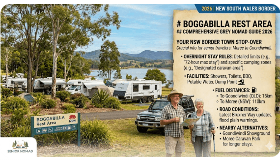
    Stop 6 — Goondiwindi Rest Area (195 km from Dirranbandi / End Point)

    Goondiwindi — affectionately known as “Gundy” — marks the south-eastern end of this route and the gateway to the New South Wales border. With a population of around 6,500, it is the largest town on the entire drive and offers comprehensive services: multiple supermarkets, several fuel stations, a hospital, and a wide selection of caravan parks for those wanting a powered site after several nights of free camping.

    The town is set on the MacIntyre River and has excellent walking paths along the riverbank, a heated public pool, and a vibrant agricultural heritage. It is a fantastic place to rest up for a day or two before continuing south into New South Wales or east toward Toowoomba and the Darling Downs.

    Goondiwindi Rest Area is well-suited to travellers arriving late in the day or those who prefer free camping over paid parks. The site accommodates larger rigs and provides a practical overnight option right at the end of the route. From Goondiwindi, you are well-connected to the New England Highway, the Gore Highway toward Toowoomba, and the Newell Highway southward — making it an ideal launching point for whatever comes next.

    Who it suits: All rig sizes. Ideal as a final-night camp or a base for exploring Goondiwindi’s town attractions over a rest day or two.

    Key feature: Largest town on the route with full services, river walks, and excellent highway connections for onward travel into NSW or toward Toowoomba.

    5. Best Overnight Stops for Seniors

    Not every rest area along the Charleville to Goondiwindi route is equally suited to a comfortable overnight stay. If you are prioritising ease of access, safety, proximity to services and ability to park a larger rig, here are all ten stops ranked by overall overnight comfort:

    Rest Area Type Best For Big Rigs?
    Charleville Rest Area Core Stop First night — full town services ✅ Yes
    Morven Rest Area Core Stop Fatigue break or quiet overnight ✅ Yes
    Mitchell Rest Area Core Stop Multi-night base — spa, supplies, social ✅ Yes
    St George Rest Area Core Stop Midpoint hub — fishing, hospital, resupply ✅ Yes
    Dirranbandi Rest Area Core Stop Quiet small-town overnight, star gazing ✅ Yes
    Goondiwindi Rest Area Core Stop Final night — largest town, full services ✅ Yes
    Yowah Rest Area Branch Stop Pre-route overnight — opal fields character ✅ Yes
    Isisford to Bimerah Rd Branch Stop Northern approach staging point ⚠️ Check
    Moolayember Rest Area Branch Stop Bush camp detour north of Mitchell ⚠️ Check
    Cooningheera Waterhole Branch Stop Scenic waterhole — bush solitude ⚠️ Check

    💡 Tip: For the best overnight experience, plan your longest stops at Mitchell Rest Area and St George Rest Area. Both are close to town services, attract fellow grey nomads during the season, and have enough nearby attractions — the spa at Mitchell, the river at St George — to justify two-night stays.

    6. Safest Places to Stop

    Safety is non-negotiable for senior travellers, and the good news is that this route passes through some of the most low-crime communities in Australia. That said, perceived safety matters — especially for solo travellers or couples new to free camping.

    The safest overnight options are those closest to town centres, where other travellers are likely to be present and help is nearby. Mitchell Rest Area free camping consistently attracts a healthy number of fellow grey nomads during the travel season, which creates a natural community atmosphere. Similarly, stopping at St George Rest Area puts you close to a town with a police station, hospital, and reliable phone reception. The Charleville and Goondiwindi rest areas also score highly for safety due to their proximity to larger towns.

    If you are a solo female traveller or a couple who prefers not to camp alone in remote areas, avoid the more isolated branch stops — Cooningheera Waterhole, Moolayember and Isisford to Bimerah Rd — unless you are travelling in convoy or are experienced with remote bush camping. Stick to the town-adjacent core stops and consider alternating free camps with caravan parks for added peace of mind.

    💡 Safety Tip: Arrive at your chosen rest area before 3 pm whenever possible. This gives you daylight to assess the site, choose a good position, set up camp and identify any potential issues — all much harder after dark. It also means other campers are already present and visible.

    7. Fuel Stops and Distances

    Fuel management is arguably the single most important logistical consideration on the Charleville to Goondiwindi route. Here is a breakdown of every segment and whether fuel is available:

    Segment Distance Fuel Available?
    Yowah → Charleville 160 km Limited at Yowah — fill at Charleville
    CharlevilleMorven 85 km Yes (Morven — check hours)
    MorvenMitchell 88 km Yes (Mitchell — reliable hours)
    MitchellSt George 180 km ❌ No fuel between towns
    St GeorgeDirranbandi 100 km Yes (Dirranbandi — limited hours)
    DirranbandiGoondiwindi 195 km ❌ No fuel between towns

    ⚠️ Critical Fuel Warning: The two longest fuel gaps — Mitchell to St George (180 km) and Dirranbandi to Goondiwindi (195 km) — are both within range of a standard tow vehicle, but only if you start each segment with a full tank. If your rig is heavy and your vehicle returns 20+ litres per 100 km while towing, carry a 20-litre jerry can as insurance. Never assume small-town fuel stations will be open on weekends or public holidays.

    8. Dump Points Along This Route

    Dump point access is critical for self-contained travellers using cassette toilets or holding tanks. On the Charleville to Goondiwindi route, your best dump point opportunities are at the four main towns:

    Town Dump Point Location Notes
    Charleville Showgrounds area / caravan parks Empty before departure — start clean
    Mitchell Near town public facilities Good mid-route service point
    St George Town facilities / caravan parks Logical place for thorough tank empty after multiple free camp nights
    Goondiwindi Near caravan parks / visitor centre area End-of-route service opportunity

    Dump points are generally not available at the branch stops — Yowah, Isisford to Bimerah Rd, Moolayember or Cooningheera Waterhole — so plan your cassette toilet capacity accordingly if you intend to use these more remote sites. Check the CamperMate or WikiCamps app for the most current dump point locations and user reviews.

    9. Free Water Availability

    Water is your most important resource on any inland Queensland route. The four main towns — Charleville, Mitchell, St George and Goondiwindi — all have potable town water available at various public taps, caravan parks and visitor information centres. Fill your tanks at every opportunity, even if they are half full. Out here, topping up is a habit, not a chore.

    Between towns and at remote branch stops like Cooningheera Waterhole Rest Area and Moolayember Rest Area, water availability is effectively zero unless a rest area has a designated tap. Do not rely on waterholes or river water for drinking without proper treatment. Carry a minimum of 10 litres of drinking water per person as an emergency reserve, separate from your van’s main tank.

    The bore water in this region is often high in mineral content. It is safe for showering and washing but may taste strongly of sulphur. If you are particular about drinking water taste, fill your tanks from town mains supplies rather than bore taps.

    ⚠️ Warning: Do not assume every rest area has a working water tap. Conditions change seasonally, and taps can be turned off during drought or maintenance. If you are planning to overnight at Yowah Rest Area or the Isisford to Bimerah Rd Rest Area before reaching Charleville, arrive with full tanks and enough reserve water to be completely independent for at least 48 hours.

    10. Road Conditions and Hazards

    The main highway corridor on the Charleville to Goondiwindi route is sealed and generally well-maintained. However, “sealed” does not mean “perfect.” Here is what to expect and plan for:

    Road trains. You will encounter road trains — particularly between Mitchell and St George on the Carnarvon Highway and on the Warrego Highway west of Mitchell. Give them space. Pull left and slow down when they pass. The wind buffeting from a triple road train can unsettle a caravan significantly.

    Narrow bridges. Several older bridges along the route are single-lane or narrow two-lane. Approach slowly, check for oncoming traffic, and never try to rush across while towing.

    Wildlife. Kangaroos, emus and feral pigs are active at dawn and dusk. Do not drive during these periods if you can avoid it. The Carnarvon Highway south of Mitchell is particularly notorious for kangaroo strikes after dark.

    Flooding. After heavy rain, low-lying sections of road — particularly near Dirranbandi and along the Balonne River system near St George — can flood rapidly. Check road conditions with Queensland’s 131940 service before travelling during or after rain events.

    Fatigue. Long, flat, straight roads create a monotony that breeds drowsiness. Stop every two hours without exception. Every rest area on this route — from Morven Rest Area to Dirranbandi Rest Area — exists precisely for this purpose.

    ⚠️ Branch Stop Road Warning: If you are detouring to Moolayember Rest Area north of Mitchell, the Isisford to Bimerah Rd Rest Area further north-west, or Cooningheera Waterhole Rest Area near St George, be aware that access roads may include unsealed sections. Check conditions locally and ensure your rig is suitable for the surface before committing to any detour — especially after recent rain.

    11. ⚠️ What Travellers Get Wrong About This Route

    After years of gathering feedback from grey nomads who have driven the Charleville to Goondiwindi route, the same mistakes surface repeatedly. Here is what trips people up — and how to avoid each one:

    Mistake 1: Trying to drive it in one day. At 680 kilometres while towing, this is a recipe for dangerous fatigue. Plan for at least three overnight stops — Charleville, Mitchell and St George at minimum.

    Mistake 2: Assuming all fuel stations are open seven days. In towns like Morven and Dirranbandi, fuel station hours can be limited. Always fuel up at the larger towns where trading hours are reliable.

    Mistake 3: Underestimating the Mitchell to St George stretch. At 180 kilometres with no services, this is the section where breakdowns cause the most stress. Carry basic recovery gear and ensure your spare tyre is inflated before leaving Mitchell Rest Area.

    Mistake 4: Skipping St George. Some travellers bypass St George in a rush to reach Goondiwindi. The town is genuinely enjoyable, the Balonne River fishing is superb, and St George Rest Area free camping offers a quality overnight. Spend at least one night here.

    Mistake 5: No communication backup. Mobile coverage is unreliable on the long stretches. Carry a satellite communicator (Garmin inReach, Zoleo) or a personal locator beacon. This is not optional for older travellers.

    Mistake 6: Ignoring the branch stops. Travellers who stick rigidly to the highway miss some of the best camping on the route. If your rig is suitable, detours to Cooningheera Waterhole or Moolayember Rest Area add genuine depth to the experience.

    12. Best Time of Year to Travel

    The optimal window for the Charleville to Goondiwindi route is April through September. During these months, daytime temperatures range from 18°C to 28°C, nights are cool and comfortable for sleeping without air conditioning, and rainfall is at its lowest. Flies are less intense in the cooler months, and free camping spots like Dirranbandi Rest Area and Yowah Rest Area are significantly more pleasant.

    Avoid December through February entirely. Summer temperatures in inland Queensland regularly exceed 40°C, and the combination of extreme heat, flies, dust and storm risk makes travel unpleasant and potentially dangerous for older travellers. Flooding can close roads near Dirranbandi and St George for days or weeks.

    The peak grey nomad season is May through August. If you prefer quieter camps, travel in April or September when the weather is still excellent but the crowds have thinned considerably.

    💡 Tip: Winter nights inland can drop below 5°C and occasionally approach freezing. Ensure your van has adequate bedding and that your gas system can handle cold overnight temperatures. If you rely on diesel heating, test it before departure from home — not in a rest area at midnight when it is 2°C outside.

    13. Caravan Parks vs Free Camping

    The Charleville to Goondiwindi route offers a genuine choice between paid caravan parks and free camps. Here is how they compare on this particular corridor:

    Caravan parks are available in Charleville, Mitchell, St George and Goondiwindi. Expect to pay between $35 and $55 per night for a powered site in 2026. Parks in this region are generally well-maintained and offer laundry, camp kitchens and dump points. They are the better choice if you want reliable power for air conditioning, hot showers, and social interaction with fellow travellers.

    Free camping is the default mode for many grey nomads on this route, and the rest areas we have covered make it entirely practical. The six core stops — Charleville, Morven, Mitchell, St George, Dirranbandi and Goondiwindi — give you a free camp option at every stage. The four branch stops — Yowah, Isisford to Bimerah Rd, Moolayember and Cooningheera Waterhole — add even more options for those who prefer bush solitude.

    A smart strategy: alternate free camps with caravan park nights. Free camp for two or three nights, then book a park night for laundry, a long hot shower, full battery charging and a dump point visit. This approach keeps costs down while maintaining comfort and hygiene.

    14. 7-Day Sample Itinerary

    This itinerary assumes you are starting in Charleville and finishing in Goondiwindi, with two rest days built in at Mitchell and St George. Adjust the pace to suit your comfort level.

    Day Activity Overnight
    Day 1 Explore Charleville — Cosmos Centre, Bilby Experience, stock up supplies, fill water tanks, check rig thoroughly, empty dump point Charleville Rest Area
    Day 2 Drive to Morven Rest Area (85 km, morning tea stop) → continue to Mitchell (88 km). Soak at the Great Artesian Spa. Mitchell Rest Area
    Day 3 Rest day in Mitchell. Second spa session, walk the town, bottle tree forest. Optional detour to Moolayember Rest Area for a bush camp experience north of town. Mitchell
    Day 4 Drive Mitchell → St George (180 km). Early start essential. Fill fuel before leaving. Arrive early afternoon. Walk the Balonne River. St George Rest Area
    Day 5 Rest day in St George. Fish the Balonne. Walk the town. Optional scenic afternoon at Cooningheera Waterhole Rest Area — one of the most peaceful spots on the route. St George
    Day 6 Drive St George → Dirranbandi (100 km). Relax in the afternoon. Outstanding star gazing after dark — minimal light pollution. Dirranbandi Rest Area
    Day 7 Drive Dirranbandi → Goondiwindi (195 km). Early start, full tank. Arrive by lunch. Explore town, walk the MacIntyre River, resupply, celebrate finishing the route. Goondiwindi Rest Area

    💡 Extended Itinerary Tip: If you have 10 days instead of 7, add a pre-route night at Yowah Rest Area (or the Isisford to Bimerah Rd Rest Area if approaching from the north), plus an extra rest day in Goondiwindi. The additional days transform this from a solid drive into a genuinely relaxing outback holiday.

    15. Senior Safety Tips

    Travelling the Charleville to Goondiwindi route is straightforward, but complacency is the enemy of safety. These tips are specific to this route and to older travellers:

    Drive only between 7 am and 3 pm. This avoids the worst kangaroo activity periods and ensures you are set up in camp well before dark. On the longer stretches — Mitchell to St George and Dirranbandi to Goondiwindi — an early departure is non-negotiable.

    Carry a current prescription list. The nearest major hospital is in Toowoomba or Roma. Smaller town hospitals can dispense emergency medication, but only if they know what you are taking. Keep a printed list in your wallet and a photo on your phone.

    Share your itinerary. Tell a family member your planned route, expected stops and check-in times. If you miss a check-in, they know where to start looking.

    Never drive fatigued. If you feel drowsy, pull over immediately. Morven Rest Area and every other rest stop on this route exist precisely for this purpose — use them without hesitation.

    Carry a first aid kit rated for remote travel. Include snake bandages, burn gel, antihistamines, a thermal blanket and a tourniquet. A standard home first aid kit is insufficient for outback travel.

    Test your battery system before departure. If your house batteries fail mid-route, you lose refrigeration, lighting and potentially CPAP machine power. Ensure your solar, alternator charging and battery monitor are all functional before leaving Charleville.

    ⚠️ CPAP Users: If you rely on a CPAP machine for sleep apnoea, ensure you have sufficient battery capacity to run it for at least two nights without shore power or solar input. Cloudy days happen, and not every free camp — particularly the remote branch stops like Cooningheera Waterhole and Moolayember — will charge your batteries adequately. Carry a backup battery if possible.

    16. What to Pack

    Packing for the Charleville to Goondiwindi route is about covering the basics and preparing for self-reliance. Between towns, assume you are on your own — especially if you plan to visit the branch stops.

    Vehicle and Rig Essentials

    • Full-size inflated spare tyre (plus tyre repair kit and 12V compressor)
    • 20-litre jerry can of diesel or petrol
    • Tow-rated recovery strap and rated shackles
    • Jumper leads or portable lithium jump starter
    • Basic tool kit — spanners, pliers, electrical tape, cable ties, spare fuses
    • Levelling blocks and wheel chocks
    • Spare fan belt and radiator hose (for older vehicles)

    Personal and Comfort

    • Minimum 10 litres of emergency drinking water per person (separate from main tank)
    • Sun protection — broad-brimmed hat, SPF50 sunscreen, long-sleeve shirts
    • Insect repellent — flies are relentless in the warmer months
    • Warm layers for overnight — winter nights inland can drop below 5°C
    • Folding chairs and a camp table
    • Torch and headlamp with spare batteries
    • A good book — the evenings are long and peaceful out here

    Communication and Navigation

    • Satellite communicator (Garmin inReach, Zoleo) or personal locator beacon (PLB)
    • Offline maps — Hema Explorer app or downloaded Google Maps regions
    • UHF radio (Channel 40 for general travel, Channel 18 for caravans)
    • Printed route notes as backup to electronic navigation

    📥 Downloadable Packing Checklist

    We recommend printing a packing checklist and keeping it in your glove box. A printable version tailored for grey nomads travelling inland Queensland routes — covering vehicle spares, personal gear and communication equipment — is available on our full Queensland route guide page.

    17. Nearby Alternative Routes

    The Charleville to Goondiwindi route connects naturally to several other inland Queensland corridors. Here is how each links in, and which of our covered rest areas you will pass along the way:

    Charleville to Longreach (north-west): Continue the outback experience via the Landsborough Highway toward Longreach and the Australian Stockman’s Hall of Fame. Travellers heading this direction can stage overnight at the Isisford to Bimerah Rd Rest Area along the way.

    Mitchell to Carnarvon Gorge (north): A spectacular side-trip for nature lovers. Moolayember Rest Area sits along this corridor and provides a bush camp option on the journey north toward one of Queensland’s most impressive national parks.

    Charleville to Quilpie and Yowah (west): If you have not yet visited the opal fields, stopping at Yowah Rest Area on the way through is an easy and rewarding addition. The fossicking community at Yowah is unlike anywhere else in Queensland.

    St George scenic loop via Cooningheera: Rather than driving straight through St George, take a half-day detour to Cooningheera Waterhole Rest Area for one of the most scenic bush camps in the region before returning to the main route.

    Goondiwindi to Stanthorpe (east): Head east along the New England Highway into the Granite Belt wine region — a wonderful contrast to the outback country you have just crossed.

    St George to Lightning Ridge (south into NSW): A popular grey nomad loop through the opal towns of outback New South Wales.

    💡 Planning Your Wider Loop: For a comprehensive look at all the inland Queensland routes suited to grey nomads — including connecting corridors, seasonal planning and rest area guides across the entire state — visit our Queensland inland routes for grey nomads 2026 hub page.

    18. Frequently Asked Questions

    Is the Charleville to Goondiwindi route sealed the whole way?

    Yes. The primary route — via the Warrego Highway, Carnarvon Highway and Balonne/Barwon Highway — is fully sealed. Side-trips to branch stops such as Cooningheera Waterhole Rest Area, Moolayember Rest Area, Yowah Rest Area or the Isisford to Bimerah Rd Rest Area may involve short unsealed sections. Always check conditions before detouring with a larger rig.

    Can I do this route in a large caravan or fifth-wheeler?

    Absolutely. The main highways are wide enough for large rigs, and the core rest areas — Charleville, Morven, Mitchell, St George, Dirranbandi and Goondiwindi — can accommodate larger setups. If you are towing over 20 feet, check access before committing to the branch stops where turning space may be limited.

    Is there mobile phone reception along the route?

    You will have reception in and around the main towns (Charleville, Morven, Mitchell, St George, Dirranbandi, Goondiwindi). Between towns, reception is patchy to non-existent — particularly on the Mitchell to St George and Dirranbandi to Goondiwindi stretches. A satellite communicator is strongly recommended for all travellers on this route.

    How many days should I allow for this drive?

    A minimum of four days for comfortable travel with basic stops, but seven days is ideal if you want rest days at Mitchell and St George. If you plan to include branch stops like Yowah or Cooningheera Waterhole, allow 10 days for the full experience.

    Are dogs allowed at the free camps on this route?

    Policies vary by individual rest area and managing authority. In general, dogs are permitted at most roadside rest areas provided they are kept on a lead and you clean up after them. Check signage at each stop. National park areas or council-managed reserves may have specific restrictions.

    What if I break down between towns?

    Contact RACQ (or your state motoring association) if you have mobile reception. If not, use your satellite communicator or activate your PLB. Stay with your vehicle — never attempt to walk for help in outback Queensland. Carry sufficient water and shelter materials to wait comfortably. Road trains and other travellers pass regularly during daylight hours, but you cannot rely on being found quickly on the quieter sections.

    19. Final Verdict

    The Charleville to Goondiwindi route is one of the finest inland drives in Queensland for grey nomads who want wide-open country, genuine outback character and reliable free camping without the remoteness risk of the far west. The road is sealed, the towns are friendly, and the free camps — all ten of them, from branch stops like Yowah Rest Area and Isisford to Bimerah Rd Rest Area on the approach, through every core stop at Charleville, Morven, Mitchell, St George, Dirranbandi and Goondiwindi, to scenic detours at Moolayember and Cooningheera Waterhole — provide comfortable overnight options at every stage of the journey.

    It is not a route that grabs attention the way the Savannah Way or the Gibb River Road does. There are no Instagram-famous gorges or turquoise waterholes. What it offers instead is something more valuable to most of us: a relaxed, safe, well-paced drive through country that still looks and feels like the Australia many of us grew up hearing about. The sunsets over the Mitchell grass plains are worth the drive alone.

    Take your time. Stop at Morven for a cuppa. Soak your joints at Mitchell. Throw a line in the Balonne at St George. Watch the stars from Dirranbandi Rest Area. And when you roll into Goondiwindi with red dust on the windscreen and a week of outback quiet behind you, you will understand exactly why this route deserves a place in every grey nomad’s travel plan.

    Safe travels in 2026.

    This article is part of the Retire to Van Life route guide series. For connecting routes, seasonal planning and rest area guides across Queensland’s entire interior, visit our Queensland inland routes for grey nomads 2026 hub page.

    🏨 Park full? Search Local Accommodation Below When Van Life Becomes Exhausting.

    Free campsites and powered sites fill fast during school holidays and peak season. If your preferred site is already gone, search remaining accommodation options below to explore the region.


    Accommodation and flight search powered by Expedia. Booking through this search supports this website at no extra cost to you. As an affiliate, I earn from qualifying purchases at no extra cost to you.

    RV LIFE Trip Wizard

    RV LIFE Trip Wizard

    As an affiliate, I earn from qualifying purchases at no extra cost to you.

    Exclusive Offer: Get 5% OFF all StarterStopper immobiliser products with promo code: RTV5

    Visit StarterStopper.com to see our data-backed security solutions

    As an affiliate, I earn from qualifying purchases at no extra cost to you.

  • Capella Rest Area — Free Camping & Senior Grey Nomad Guide 2026

    The Capella Rest Area most travellers are referring to is the public stop at Capella Geo Park on Peak Downs Street, Capella QLD 4723, beside Capella Creek in central Queensland.

    Capella Rest Area — Free Camping & Senior Grey Nomad Guide 2026

    The Capella Rest Area most travellers are referring to is the public stop at Capella Geo Park on Peak Downs Street, Capella QLD 4723, beside Capella Creek in central Queensland. It sits just off the Peak Downs Highway, about 52 km west of Emerald and roughly 101 km east of Clermont, making it a popular break point for caravanners, motorhome travellers and senior grey nomads moving through the Central Highlands.

    For older travellers, Capella is more than just a quick roadside pull-in. It is a practical inland stop with easy sealed access, town services nearby, shaded park areas, short walking options, fuel, basic supplies and a paid caravan park close by if you need a more comfortable overnight stay. That combination makes Capella one of the more useful senior-friendly stopping points on this stretch of highway.

    In this 2026 guide, I’ll walk you through exactly where the Capella Rest Area is, whether overnight stays are allowed, what facilities are nearby, how suitable it is for caravans and motorhomes, whether roads can flood, where the nearest fuel is in every direction, and which backup camping and caravan park options make the most sense for seniors who want a safer, easier stop.

    ⚠️ Overnight Stay Warning: Many travellers use the phrase “Capella Rest Area free camping”, but a pleasant park or roadside stop is not automatically a legal overnight camp. Read all local signage at the site, especially if arriving late in 2026.

    1. Why Grey Nomads Stop at Capella Rest Area

    Capella is one of those country Queensland stops that works well for older travellers because it is easy to access, relatively level, and close to day-use facilities. For drivers moving between Emerald and Clermont, or linking inland Queensland routes with the Capricorn coast, it is a logical place to pull over, stretch the legs, have lunch and reset before the next run.

    The township’s appeal comes from convenience. You have fuel, groceries, public amenities in town, a caravan park for those wanting power and showers, and the attractive Capella Geo Park area near Capella Creek. For seniors, that combination matters more than the words “free camp”. A stop is only truly useful if it is comfortable, safe, and close to services when something goes wrong.

    ✅ Senior Tip: Capella is best treated as a service stop first and a possible overnight only if local signage permits. If you need a powered site, level ground, a proper shower or certainty in wet weather, choose the caravan park rather than guessing.

    For more trip planning help, see best routes to drive around Australia for grey nomads and living in a camper in retirement.

    2. Capella Rest Area Location, Address, GPS and Public WiFi

    The location most travellers refer to as Capella Rest Area is the public day-use area at Capella Geo Park on Peak Downs Street beside Capella Creek in Capella QLD 4723. Publicly available mapping places the geo park close to the centre of town with covered seating, open green space, short walking paths and parking suitable for general travellers.

    Capella Rest Area / Geo Park Location Details
    Name Capella Geo Park
    Common search term Capella Rest Area
    Address Peak Downs Street, Capella QLD 4723
    GPS -23.0859, 148.0229
    Coordinate source Publicly available map listing for Capella Geo Park
    GPS accuracy note Use as the geo park entry/day-use reference point; verify parking position on arrival
    Nearby public WiFi Public WiFi may be available at local library/council or visitor-facing town facilities; confirm locally on arrival
    Notes Best suited to daytime rest, walking and short breaks; overnight permission depends on current local signage
    ⚠️ GPS Safety Note: The coordinate above is for the commonly referenced Capella Geo Park location used by travellers searching for Capella Rest Area. Parking layouts, entry points and overnight rules can change. Use the GPS as a navigation aid, then confirm signage once on site.

    3. Is Capella Rest Area Really Free Camping?

    This is the big question, and it is where many ranking pages stay vague. In practical terms, Capella Rest Area is better understood as a town rest stop/day-use area than a guaranteed free camp. Some travellers may stop overnight if signage allows, but you should not assume every parking bay or public park in Capella permits sleeping in a vehicle.

    For senior travellers, the safest approach is simple:

    • Treat Capella Geo Park as a rest area unless signs clearly permit overnight stays.
    • If you need certainty, book a site at Capella Caravan Park.
    • If you arrive late, tired, or in rain, choose the paid option rather than risking a move-on request.

    This matters even more in 2026 because local councils across Australia continue tightening rules around urban free camping, especially where parks are intended for day visitors, families, events or local recreation.

    Related reading: how long can you stay in a caravan park in Australia and grey nomad caravan security tips.

    4. Quick Facts Box 2026

    Quick Facts — Capella Rest Area 2026
    Town Capella QLD 4723
    Main rest stop Capella Geo Park, Peak Downs Street, Capella QLD 4723
    GPS -23.0859, 148.0229
    Road access Sealed access via Peak Downs Highway
    Suitable for caravans Yes, town access is suitable for caravans, motorhomes and campervans
    Overnight free camping Check current signage locally before staying
    Nearest paid alternative Capella Caravan Park, Capella QLD 4723
    Nearest hospital Capella Hospital, 33 Hibernia Road, Capella QLD 4723
    Hospital GPS -23.0889, 148.0189
    Hospital phone 07 4985 3111
    Fuel east Emerald ~52 km
    Fuel west Clermont ~101 km
    Fuel north No major town fuel direct north from Capella township route; top up before leaving
    Fuel south Emerald remains the key service town to the south-east/south via connecting roads
    ✅ Medical Planning Tip: Save the Capella Hospital details before arrival in 2026. For senior travellers, having the local hospital in your phone and written in the glovebox is one of the simplest ways to reduce stress on the road.

    5. How to Get to Capella in Any Vehicle

    Capella is reached on sealed roads and is straightforward for conventional cars, campervans, caravans, motorhomes, fifth wheelers and small buses. The main approach is via the Peak Downs Highway, one of central Queensland’s better-known inland freight and traveller routes.

    • From Emerald: travel west on the Peak Downs Highway for about 52 km to Capella.
    • From Clermont: travel east on the Peak Downs Highway for about 101 km.
    • From Rockhampton: allow roughly 335 km via the Capricorn Highway to Emerald, then the Peak Downs Highway to Capella.
    • From Mackay: allow roughly 290 km via Nebo and Clermont, then east to Capella.

    Inside town, road conditions are simple and sealed. Large rigs can enter Capella without unusual difficulty, though as always, fuel station layouts and town-centre turning circles are easier in daylight than after dark.

    ✅ Driving Tip for Big Rigs: If towing a long caravan, aim to arrive mid-morning or early afternoon. You will see parking angles more clearly, fuel pumps are easier to access, and you have time to switch to the caravan park if the rest area signage does not suit your plans.

    6. Road Conditions, Flooding and Towing Safety

    The roads into Capella are predominantly sealed. For most senior travellers, that is the key point. You do not need an off-road van or 4WD just to reach the township or Capella Geo Park. However, weather still matters in central Queensland. During heavy rain events, creek crossings, low points and local roads in the wider district can be affected.

    In wet periods, the main risks are not deep outback isolation but:

    • water over low sections of road,
    • reduced visibility in storms,
    • muddy verges if you pull off the bitumen,
    • soft ground in parks or unsealed overflow areas.

    For March 2026 travel, always check the latest local road conditions before towing. Central Queensland can see late wet-season rain, and what is easy for a ute may be awkward for a heavy caravan on soft shoulders.

    ⚠️ Flood and Verge Warning: Even if the highway is open, avoid pulling a caravan onto soggy grass or creekside edges after rain. Many travellers get stuck not on the highway, but in the final 20 metres of a parking area.

    If weather turns poor, choose a firm paid site instead of a marginal free stop. That one decision can save a tow bill, a damaged coupling, or a difficult night for older bodies.

     “To see how this stop fits into your broader journey between the outback and the border, view our complete Charleville to Goondiwindi grey nomad guide for 2026.”

    COPY PROMPT ➔ ASK AI ➔ SAVE TO FORM ➔ ADD SPOT PIN ➔ GET DIRECTIONS

    📍 Interactive map — find free camps, rest areas and overnight stops. Enable location for best results.

    7. Free and Low-Cost Camping Near Capella Search

    This is where most competing pages are thin. Here is the practical breakdown for 2026.

    Use the Van Life Savings Spots app for current camping checks. Example AI prompts for this area:

    • “Find legal overnight stops near Capella QLD for caravans”
    • “Show dump points and water near Capella Queensland”
    • “Find low-cost caravan parks between Emerald and Clermont”
    Option Address / Postcode GPS Notes
    Capella Geo Park / Rest Area Peak Downs Street, Capella QLD 4723 -23.0859, 148.0229 Good day stop. Check signage for overnight legality.
    Capella Caravan Park Burnett Street, Capella QLD 4723 -23.0848, 148.0212 Best paid option for seniors needing facilities and certainty.
    Emerald showground/caravan options Emerald QLD 4720 Town-dependent Useful backup if you prefer a larger service town 52 km away.

    The clear senior verdict is this: if you are healthy, self-contained, weather is fine, and signage permits it, the Capella rest area may suit a simple stop. But if you need toilets close by, powered sleep equipment, or a more dependable overnight, the caravan park is the stronger choice.

    8. Dump Points Near Capella

    Dump Point Address / Postcode GPS Position
    🗑️ Capella Caravan Park dump point Burnett Street, Capella QLD 4723 -23.0848, 148.0212 In town
    🗑️ Emerald dump facilities Emerald QLD 4720 Varies by facility ~52 km east
    🗑️ Clermont dump facilities Clermont QLD 4721 Varies by facility ~101 km west
    ✅ Dump Point Tip: If you are unsure whether the town rest area allows overnight use, empty and refill in a proper caravan facility before deciding. That keeps your options open if you need to continue on to Emerald or Clermont.

    9. Water and Supplies Near Capella

    Capella is not a remote outback emergency stop; it is a functioning service town. That means groceries, fuel and day-to-day basics are easier than in many highway rest areas. For water, the safest approach is to top up through a caravan park or known potable supply rather than assuming every public tap is drinking water grade.

    Water / Supply Point Address / Postcode GPS Notes
    💧 Capella Caravan Park water Burnett Street, Capella QLD 4723 -23.0848, 148.0212 Ask before filling if not staying overnight
    Town supplies Capella township QLD 4723 Town centre Basic groceries, fuel and essentials

    10. Fuel Distances North, South, East and West of Capella Rest Area

    Fuel planning matters because many seniors calculate safe towing distance carefully. These are the practical route distances you should use as a planning guide in 2026:

    Direction from Capella Fuel Stop Approx. Distance Notes
    East Emerald ~52 km Major service centre; best resupply option nearby
    West Clermont ~101 km Good western fuel option on Peak Downs Highway
    North Route dependent Varies Top up in Capella before heading onto lesser-used district roads
    South Via Emerald connections Varies Emerald remains the key anchor town

    If towing, these distances are comfortable compared with many inland Queensland legs, but the smart rule still applies: fill when you can, not when you must.

    11. Facilities, Accessibility and Senior Comfort

    Capella Geo Park is attractive because it is gentler on older travellers than a bare roadside bay. It offers a better break environment with green space and seating. That said, the comfort level depends on whether you are stopping for lunch or trying to stay the night.

    • Day stop comfort: generally good
    • Shade and seating: usually the main advantage of the geo park
    • Walking: easy short strolls suit many seniors
    • Mobility: more accessible than rough bush stops
    • Overnight comfort: lower than a caravan park unless you are fully self-contained

    If you use a CPAP, need regular power, prefer a level slab, or want a proper shower, the caravan park becomes the obvious choice. Comfort matters more with age, and chasing a free night can be false economy if it costs you a poor sleep and a stiff back the next day.

    12. Things to Do in Capella for Seniors

    Capella is a short-stop town, but that does not mean it is boring. Seniors often enjoy:

    • a gentle walk through Capella Geo Park,
    • time by Capella Creek in cooler parts of the day,
    • an easy town wander for supplies and a meal,
    • using the stop as a quiet reset between Emerald and Clermont.

    If you like breaking driving days into manageable stages, Capella works well as a shorter leg rather than pushing straight through. That alone can make a long inland run much easier on senior bodies.

    13. Senior Travel Checklist for Capella 2026

    Item Why It Matters
    Hospital saved in phone Capella Hospital, 33 Hibernia Road, Capella QLD 4723, 07 4985 3111
    Fuel topped up Especially if continuing west to Clermont or onto district roads
    Check overnight signs Do not assume the day-use park is legal for overnight camping
    Dump before stopping Use Capella Caravan Park or larger towns nearby
    Water topped up Do not rely on random public taps
    Wet weather check Soft ground near parks and verges can trap vans

    14. GPS Coordinates and Postcodes Master Table

    Location Address + Postcode GPS / Notes
    Capella Rest Area / Geo Park Peak Downs Street, Capella QLD 4723 -23.0859, 148.0229 | Publicly available map source
    Capella Caravan Park Burnett Street, Capella QLD 4723 -23.0848, 148.0212
    🏥 Capella Hospital 33 Hibernia Road, Capella QLD 4723 -23.0889, 148.0189 | 07 4985 3111
    🗑️ Dump Point — Capella Caravan Park Burnett Street, Capella QLD 4723 -23.0848, 148.0212
    💧 Water — Capella Caravan Park Burnett Street, Capella QLD 4723 -23.0848, 148.0212
    Emerald Emerald QLD 4720 ~52 km east of Capella
    Clermont Clermont QLD 4721 ~101 km west of Capella

    15. FAQ — Capella Rest Area

    Can you free camp at Capella Rest Area in 2026?

    You should not assume free overnight camping is automatically allowed. Capella Geo Park is a well-known rest stop/day-use location, but you must check the current signage on arrival in 2026.

    What is the GPS for Capella Rest Area?

    The commonly referenced location is -23.0859, 148.0229 for Capella Geo Park on Peak Downs Street, Capella QLD 4723.

    Is Capella Rest Area suitable for caravans and motorhomes?

    Yes. Capella is on sealed roads and the township is accessible for caravans, campervans and motorhomes. The bigger question is overnight legality, not access difficulty.

    Is there a caravan park in Capella?

    Yes. Capella Caravan Park is the main paid overnight option and is generally the better choice for seniors who want certainty, facilities and easier overnight comfort.

    How far is Capella from Emerald?

    Capella is approximately 52 km west of Emerald via the Peak Downs Highway.

    How far is Capella from Clermont?

    Capella is approximately 101 km east of Clermont on the Peak Downs Highway.

    Does the road to Capella flood?

    The main roads are sealed, but heavy rain can affect low sections, shoulders and parking surfaces. In March 2026 especially, check local conditions before towing.

    Is there a hospital in Capella?

    Yes. Capella Hospital, 33 Hibernia Road, Capella QLD 4723. GPS: -23.0889, 148.0189. Phone: 07 4985 3111.

    Is there public WiFi near Capella Rest Area?

    Public WiFi availability can vary. Check local library, council or visitor-facing facilities in town on arrival.

    ✅ Final Senior Verdict: Capella Rest Area is a good day stop and reset point on a sealed inland route. For a true overnight with confidence, especially in 2026, most senior grey nomads will be better off using the local caravan park unless signage clearly permits staying at the rest area.

    More planning help: Van Life Savings Spots and other free camping and rest area guides.

    Disclaimer: This Capella Rest Area guide was prepared for March 2026 using publicly available location data and route information. Distances are approximate driving distances and should be rechecked before departure. GPS coordinates are intended as navigation aids only and should always be confirmed against local signage and current mapping on arrival. Overnight rules, public WiFi availability, caravan park services, dump point access, fuel trading hours and road conditions can change without notice.

    🏨 Park full? Search Local Accommodation Below When Van Life Becomes Exhausting.

    Free campsites and powered sites fill fast during school holidays and peak season. If your preferred site is already gone, search remaining accommodation options below to explore the region.


    Accommodation and flight search powered by Expedia. Booking through this search supports this website at no extra cost to you. As an affiliate, I earn from qualifying purchases at no extra cost to you.

    RV LIFE Trip Wizard

    RV LIFE Trip Wizard

    As an affiliate, I earn from qualifying purchases at no extra cost to you.

    Exclusive Offer: Get 5% OFF all StarterStopper immobiliser products with promo code: RTV5

    Visit StarterStopper.com to see our data-backed security solutions

    As an affiliate, I earn from qualifying purchases at no extra cost to you.

  • Emerald Rest Area — Free Camping Senior Grey Nomad Guide 2026

    Emerald Rest Area is one of the most convenient free overnight stops in Central Queensland for grey nomads travelling the Capricorn Highway

    Emerald Rest Area — Free Camping Senior Grey Nomad Guide 2026

    The Emerald Rest Area is one of the most convenient free overnight stops in Central Queensland for grey nomads travelling the Capricorn Highway or the Gregory Highway in 2026. Located right in the heart of Emerald — next to Morton Park and commonly called Emerald Rotary Park — this free 20-hour camping area gives senior travellers a safe, flat, in-town rest stop with toilets, a covered picnic shelter and easy walking distance to supermarkets, fuel, medical services and everything a self-sufficient van-lifer needs. Emerald sits roughly 900 km north-west of Brisbane and 270 km west of Rockhampton, making it the natural halfway point for thousands of retired travellers heading west toward Longreach, north toward the Gemfields, or south toward Carnarvon Gorge. This Emerald Rest Area free camping guide covers every facility, GPS coordinate, dump point, water source, fuel stop and medical detail a senior needs before arriving in March 2026 and beyond.

    📑 Table of Contents
    1. Why Grey Nomads Stop at Emerald Rest Area
    2. Free Camping — Looks Easy, But Know the Limits for Seniors
    3. Your Two Main Options Side by Side
    4. Quick Facts and Key Details 2026
    5. How to Get to Emerald Rest Area — Directions from Every Direction
    6. Road Conditions, Flooding and Sealed vs Unsealed Access
    7. Heat, Storms and Weather — What It Really Means for Seniors
    8. Wildlife at Emerald Rest Area — Birds, Reptiles and What to Watch For
    9. What Emerald Rest Area Doesn’t Tell You Online
    10. Best Time to Visit Emerald Rest Area — Month-by-Month Breakdown
    11. Van Life Savings Spots: Free and Low-Cost Camping Near Emerald 2026
    12. Dump Points Near Emerald Rest Area
    13. Free Water Sources Near Emerald Rest Area
    14. Fuel Stops Along Emerald’s Major Routes
    15. Emerald Caravan Parks — The Paid Alternatives for Seniors
    16. Full Facilities Comparison Table
    17. Rates — All Options Near Emerald Rest Area 2026
    18. The Emerald Day Plan for Seniors
    19. Senior Checklist — Emerald and Highway Routes
    20. What to Do Near Emerald Rest Area — Senior Activity Guide
    21. Phone Signal and Emergency Communications
    22. Campfires and Cooking at Emerald Rest Area
    23. Pets at Emerald Rest Area
    24. Accessibility for Seniors with Mobility Limitations
    25. Permits and Park Fees
    26. Reviews — What Real Grey Nomads Say About Emerald Rest Area
    27. GPS Coordinates and Postcodes — Save Every Stop
    28. People Also Ask — Emerald Rest Area
    29. Frequently Asked Questions — Emerald Rest Area
    30. Quick-Reference Card
    31. Related Free Camping Guides on Queensland Highways
    32. Disclaimer

    1. Why Grey Nomads Stop at Emerald Rest Area

    Emerald is the commercial hub of the Central Highlands region and a natural crossroads for senior travellers on multiple iconic Australian routes. Whether you are heading west along the Capricorn Highway toward Longreach and the Australian Stockman’s Hall of Fame, north to the Gemfields around Sapphire and Rubyvale, south toward Springsure and Carnarvon Gorge, or east back toward Rockhampton and the coast, Emerald is the last large town with full services for hundreds of kilometres in most directions.

    The Emerald Rest Area — also known as Emerald Rotary Park — sits right beside Morton Park on Clermont Street, within walking distance of Coles, Woolworths, the post office, chemists and the Emerald Hospital. For budget-conscious seniors living on the road in retirement, this free 20-hour stop is the ideal place to resupply, rest, see a doctor if needed, and plan the next leg of your journey without paying caravan park fees.

    Key reasons grey nomads stop here in 2026:

    • Free overnight camping — 20-hour limit, no fees, no booking required
    • In-town location — walk to supermarkets, fuel, chemist, hospital
    • Flat, sealed parking — easy for large rigs, motorhomes and caravans
    • Public toilets on site — maintained by Central Highlands Regional Council
    • Covered picnic shelter with tables — socialise with other travellers
    • Safe, well-lit area next to a public park — other travellers usually present
    • Central crossroads — gateway to Gemfields, Longreach, Carnarvon Gorge and the coast
    ✅ Senior Tip: Emerald Rest Area is popular with grey nomads year-round because it offers the rare combination of free camping inside a well-serviced town. You do not need to be self-contained — there are public toilets on site. This makes it suitable for seniors who may not have a toilet in their campervan or who prefer not to use their cassette toilet when town facilities are available.

    2. Free Camping at Emerald Rest Area — Looks Easy, But Know the Limits for Seniors

    The Emerald Rest Area is genuinely free and genuinely convenient, but it is not a caravan park. Senior travellers need to understand exactly what is — and is not — provided before relying on it as their overnight stop in 2026.

    What you get:

    • Flat, sealed parking area suitable for caravans, motorhomes and campervans
    • Public toilet block (not 24-hour showers — toilets only)
    • Covered picnic shelter with tables and seating
    • Rubbish bins
    • Adjacent to Morton Park with walking paths, open grass and shade trees
    • Street lighting — reasonably well-lit at night
    • 20-hour free stay limit

    What you do NOT get:

    • ❌ No 240V power — bring a lithium battery or generator (check noise rules)
    • ❌ No showers — use the caravan park or your own van shower
    • ❌ No dump point on site — nearest dump point is at Emerald Showgrounds (~1.5 km)
    • ❌ No potable water tap specifically for filling tanks — bring full tanks or fill at the showgrounds
    • ❌ No camp kitchen or BBQ facilities
    • ❌ No security or caretaker — this is a council rest area, not a managed park
    ⚠️ 20-Hour Limit: The Emerald Rest Area permits a maximum 20-hour stay. This is enforced by Central Highlands Regional Council. Overstaying may result in a fine and risks the rest area being closed to all free campers. Arrive in the afternoon, leave by late morning the next day. If you need a longer stay, move to one of Emerald’s caravan parks.
    ⚠️ CPAP Users: There is no mains power at Emerald Rest Area. If you use a CPAP machine, you must have a fully charged lithium battery pack or stay at a powered caravan park. The Emerald Discovery Park and Emerald Cabin & Caravan Village both offer powered sites — see Section 15.

    3. Your Two Main Options Side by Side

    Feature Emerald Rest Area (Free) Emerald Caravan Parks (Paid)
    Cost Free — 20-hour limit From ~$38–$45/night powered
    240V Power ❌ None ✅ Powered sites available
    Toilets ✅ Public toilets on site ✅ Amenity blocks — M & F
    Showers ❌ None ✅ Hot showers included
    Dump Point ❌ Nearest ~1.5 km at Showgrounds ✅ On-site or adjacent
    Potable Water ⚠️ Not designated for tank fill ✅ On-site
    Dogs ✅ On leash, clean up after ✅ Most are pet-friendly (check)
    Camp Kitchen ❌ Picnic shelter only ✅ Yes
    Phone Signal ✅ Good — Telstra, Optus in town ✅ Good — Telstra, Optus in town
    Medical Proximity ✅ ~1.5 km to Emerald Hospital ✅ ~2–3 km to Emerald Hospital
    Senior Verdict ✅ Great for 1 night, self-sufficient ✅ ← Recommended for 2+ nights or CPAP

    4. Emerald Rest Area: Quick Facts and Key Details 2026

    Below is the complete quick facts box for the Emerald Rest Area covering every essential detail a senior traveller needs in 2026.

    Quick Facts — Emerald Rest Area & Facilities 2026
    Official Name Emerald Rest Area (Emerald Rotary Park)
    Address Clermont Street (near corner of Opal Street), Emerald QLD 4720
    GPS Coordinates -23.5271, 148.1592
    Postcode 4720
    Region Central Highlands, Central Queensland
    Local Government Central Highlands Regional Council
    Distance from Brisbane ~900 km (via Capricorn Hwy)
    Distance from Rockhampton ~270 km west
    Distance from Longreach ~410 km west
    Cost Free — 20-hour limit
    Permit Required No permit required
    Toilets ✅ Public toilets on site
    Showers ❌ No showers
    240V Power ❌ No power
    Dump Point ❌ Not on site — nearest at Emerald Showgrounds (~1.5 km)
    Potable Water ⚠️ Park tap — not a designated tank-fill point. Fill at Showgrounds or caravan park.
    Picnic Shelter ✅ Covered shelter with tables
    Rubbish Bins ✅ Yes
    Surface Sealed / gravel — flat, suitable for large rigs
    Suitable Vehicles All — caravans, motorhomes, campervans, cars with rooftop tents
    Pets ✅ Dogs on leash, clean up required
    Phone Coverage ✅ Good — Telstra and Optus coverage in Emerald
    Public Wi-Fi Nearby Emerald Library — 44 Borilla Street, Emerald QLD 4720 (~800 m walk)
    Nearest Hospital Emerald Hospital, Hospital Road, Emerald QLD 4720 — Ph: 07 4987 9100
    Hospital GPS -23.5194, 148.1530
    Hospital Distance from Rest Area ~1.5 km north
    Emergency Triple Zero (000)
    Visitor Information Central Highlands Visitor Information Centre, Clermont Street, Emerald QLD 4720 — Ph: 1300 729 992
    Council Contact Central Highlands Regional Council — Ph: 1300 242 686
    Best Travel Season April to October (dry season — cooler temperatures)
    ✅ Senior Tip — Hospital Details: Emerald Hospital is a public hospital providing 24-hour emergency services, medical and surgical wards, and allied health. It is located at Hospital Road, Emerald QLD 4720, approximately 1.5 km north of the rest area. GPS: -23.5194, 148.1530. Phone: 07 4987 9100. Save this number offline and on paper in your glovebox before you arrive. There are also multiple GP clinics and a pharmacy on Egerton Street in Emerald’s CBD, all within walking or short driving distance of the rest area.

    5. How to Get to Emerald Rest Area — Directions from Every Direction

    Emerald sits at the junction of the Capricorn Highway (east–west) and the Gregory Highway (north–south). All approaches to Emerald town centre are on sealed, well-maintained highways. The rest area itself is accessed from Clermont Street — a sealed town road with easy entry and exit for large rigs.

    From the East (Rockhampton / Brisbane)

    Travel west on the Capricorn Highway (A4) from Rockhampton. The distance is approximately 270 km and takes around 3 hours. The road is fully sealed and in good condition. As you enter Emerald from the east, continue along the Capricorn Highway which becomes Egerton Street through town. Turn left (south) onto Clermont Street. The rest area is on your left, adjacent to Morton Park. GPS: -23.5271, 148.1592.

    From the West (Longreach / Barcaldine)

    Travel east on the Capricorn Highway (A4). From Longreach, the distance is approximately 410 km (around 4.5 hours). From Barcaldine, it is approximately 290 km (around 3 hours). The road is fully sealed. As you enter Emerald from the west, follow the Capricorn Highway (Egerton Street) through town and turn right (south) onto Clermont Street to reach the rest area.

    From the North (Clermont / Mackay direction)

    Travel south on the Gregory Highway (A68) from Clermont. The distance is approximately 110 km (around 1.25 hours). The road is fully sealed. As you enter Emerald from the north, the Gregory Highway becomes Clermont Street. Continue south on Clermont Street — the rest area is on your right-hand side next to Morton Park.

    From the South (Springsure / Carnarvon Gorge direction)

    Travel north on the Gregory Highway (A68) from Springsure. The distance is approximately 67 km (around 45 minutes). The road is fully sealed. As you enter Emerald from the south, follow the Gregory Highway which becomes Clermont Street. The rest area is on your left, adjacent to Morton Park.

    “This stop is a key part of the inland network; you can see how it connects to the broader south-west region in our Charleville to Goondiwindi grey nomad guide.”

    ✅ Rig-Friendly Tip: The Emerald Rest Area has easy access for large caravans, fifth-wheelers and motorhomes. Clermont Street is a wide, sealed town road. There is plenty of room to manoeuvre and park without needing to unhitch. If you are coming from the Capricorn Highway (east or west), the turn onto Clermont Street is straightforward — no tight roundabouts or low-clearance bridges.

    6. Road Conditions, Flooding and Sealed vs Unsealed Access

    All major approaches to Emerald are on sealed, well-maintained state highways. The Capricorn Highway (east–west) and Gregory Highway (north–south) are bitumen roads suitable for all vehicles including large rigs towing caravans. The rest area itself is accessed via sealed town streets.

    However — flooding is a genuine concern in Emerald.

    Emerald sits on the Nogoa River and is in a flood-prone area. The town experienced devastating floods in 2008, 2010–2011 and 2013. During the wet season (December to March), heavy rainfall can cause the Nogoa River and local creeks to flood, temporarily cutting roads and making low-lying areas of town inaccessible. March 2026 is the tail end of the wet season — check road conditions before travelling.

    ⚠️ Flood Warning — March 2026: March is the end of the wet season in Central Queensland. The Capricorn Highway west of Emerald and roads toward Carnarvon Gorge can flood after heavy rain. Always check road conditions before departing. Use:
    • RACQ Road Conditions: roadconditions.racq.com.au
    • QLDTraffic: qldtraffic.qld.gov.au or phone 13 19 40
    • Central Highlands Regional Council: 1300 242 686
    • BOM Flood Warnings: bom.gov.au/qld/warnings
    If a road is marked “Closed” or “Flooded,” do not attempt to cross. If it’s flooded, forget it.

    Side roads and attractions: If you are planning to visit the Gemfields (Sapphire, Rubyvale — ~45 km west of Emerald) or Carnarvon Gorge (~250 km south), some access roads are unsealed. The Rubyvale Road from the Capricorn Highway is sealed to Sapphire but becomes unsealed to Rubyvale. The road into Carnarvon Gorge National Park is partially unsealed and can become impassable in wet weather. These side trips require checking road conditions individually.

    7. Heat, Storms and Weather — What It Really Means for Seniors

    Emerald has a semi-arid subtropical climate. Summers (December–February) are hot and humid with temperatures regularly exceeding 35°C and peaking above 40°C. The wet season runs from November to March with thunderstorms, heavy rain and the possibility of flooding. Winter (June–August) is mild and dry — ideal for senior travellers — with daytime temperatures of 22–26°C and cool nights around 8–12°C.

    Month Avg Max °C Avg Min °C Rain (mm) Senior Notes
    January 34 23 ~110 ⚠️ Hot, humid, storms. Flood risk. Not recommended.
    February 33 22 ~100 ⚠️ Wet season continues. Roads may close.
    March 32 21 ~60 ⚠️ End of wet season. Check roads. Still hot.
    April 30 17 ~25 ✅ Cooling down. Dry season starting. Good for travel.
    May 26 12 ~20 ✅ Ideal. Dry, pleasant days, cool nights.
    June 23 9 ~15 ✅ Ideal. Peak grey nomad season begins.
    July 23 7 ~10 ✅ Ideal. Coldest nights — bring warm bedding.
    August 25 8 ~5 ✅ Excellent. Warm days, dry, clear skies.
    September 29 13 ~10 ✅ Good. Warming up, still dry.
    October 32 17 ~30 ⚠️ Getting hot. Storms possible late month.
    November 34 20 ~55 ⚠️ Hot. Wet season begins. Plan accordingly.
    December 35 22 ~85 ⚠️ Extreme heat. Storms frequent. Not ideal for seniors.
    ✅ Best Months for Seniors: May, June, July and August are the ideal months to visit Emerald Rest Area. Temperatures are mild, rainfall is minimal, roads are open, and the rest area is less crowded than during school holiday peaks. If you are travelling in March 2026, carry extra water and check road conditions daily.

    8. Wildlife at Emerald Rest Area — Birds, Reptiles and What to Watch For

    The Emerald Rest Area is in a town setting adjacent to Morton Park, so you will not encounter the extreme wildlife risks of remote bush camps. However, Central Queensland has its share of fauna worth knowing about:

    • Birds: Morton Park attracts a range of inland Queensland birds including galahs, corellas, lorikeets, kookaburras, butcherbirds and magpies. The Botanic Gardens (~2 km south) are excellent for birdwatching. The nearby Fairbairn Dam (~18 km south) attracts pelicans, cormorants and waterbirds.
    • Kangaroos and wallabies: Common around the edges of town and on the drive to/from Emerald. Be extremely cautious driving at dawn and dusk — kangaroo strikes are a serious risk on the Capricorn Highway.
    • Snakes: Eastern brown snakes and carpet pythons are present in the region. In Morton Park, the grass and garden beds can harbour snakes, especially in warmer months. Wear closed shoes when walking after dark and use a torch.
    • Spiders: Redback spiders are common — check under toilet seats, picnic tables and outdoor furniture before sitting.
    • No crocodiles: Emerald is well south of crocodile country. The Nogoa River does not have crocodiles.
    ⚠️ Kangaroo Collision Warning: Kangaroos are a serious hazard on all highways around Emerald, especially the Capricorn Highway and Gregory Highway. Do not drive at dawn, dusk or after dark if possible. If you must drive in low light, reduce speed and use high beam when safe. A bull bar is strongly recommended for any vehicle towing a caravan in this region.

    9. What Emerald Rest Area Doesn’t Tell You Online

    Most online listings for the Emerald Rest Area give you the basics — “free, 20 hours, toilets.” Here is what experienced grey nomads know that the websites leave out:

    • Train noise: Emerald is a coal railway town. The Queensland Rail line runs through town and coal trains can pass through during the night. If you are a light sleeper, bring earplugs or park at the far end of the rest area away from the railway side.
    • Mining traffic: Emerald services major coal mines. You will share the Capricorn Highway with heavy mining vehicles and road trains, especially west of town. Give them space and be patient with overtaking — they cannot stop quickly.
    • The rest area can be busy: In peak season (May–August), the rest area fills up by mid-afternoon. Arrive by 2:00 PM if you want a good spot. If it is full, the Emerald Showgrounds offers overflow camping (see Section 11).
    • Lighting and safety: The rest area benefits from street lighting and its location next to a public park in a residential area. However, it is not staffed or fenced. Use common sense — lock your vehicle, do not leave valuables visible, and be aware of who is around you. Solo women travellers should consider the caravan park as an alternative if the rest area feels uncomfortable.
    • Supermarkets close by 9 PM: Both Coles and Woolworths are within walking distance (~600 m to 1 km) on Egerton Street. Stock up before they close as there are no 24-hour options.
    • Public Wi-Fi: Free public Wi-Fi is available at the Emerald Library, 44 Borilla Street, Emerald QLD 4720, during opening hours. This is approximately 800 m walk from the rest area.
    • No grey water drainage: Do not drain grey water at the rest area. Use the dump point at the Showgrounds or a caravan park.
    ✅ Insider Tip: The Central Highlands Visitor Information Centre is very close to the rest area on Clermont Street. Drop in during business hours for free maps, local tips, Gemfields fossicking information and road condition updates. They are very helpful to grey nomads. Phone: 1300 729 992.

    10. Best Time to Visit Emerald Rest Area — Month-by-Month Breakdown

    The month-by-month weather table above (Section 7) gives you the numbers. Here is the senior-specific advice:

    • April–September 2026: ✅ The sweet spot. Dry, mild and roads are open. This is when the majority of grey nomads pass through Emerald heading west to Longreach and the outback.
    • October–November: ⚠️ Getting hot. Late thunderstorms possible. Still workable for short stays but plan early morning arrivals.
    • December–March: ⚠️ Hot and humid with significant rain risk. March 2026 is the tail end of the wet — check roads daily and carry extra water and supplies.

    11. Van Life Savings Spots: Free and Low-Cost Camping Near Emerald 2026

    Use the Van Life Savings Spots app to find, save and navigate to free camps around Emerald. Try these AI queries tailored to this location:

    • “Free camping near Emerald QLD with toilets”
    • “Rest areas between Rockhampton and Emerald Capricorn Highway”
    • “Dump points near Emerald QLD 2026”
    • “Overnight caravan stops Gemfields Sapphire Rubyvale”
    • “Free camps between Emerald and Longreach”

    COPY PROMPT ➔ ASK AI ➔ SAVE TO FORM ➔ ADD SPOT PIN ➔ GET DIRECTIONS

    📍 Interactive map — find free camps, rest areas and overnight stops. Enable location for best results.

    Site Name Cost Address / Postcode GPS Senior Verdict
    Emerald Rest Area (Rotary Park) Free — 20 hrs Clermont Street, Emerald QLD 4720 -23.5271, 148.1592 ✅ In-town, toilets, flat, easy access. Top pick for 1 night.
    Emerald Showgrounds Low cost (~$10–$15/night) Borilla Street, Emerald QLD 4720 -23.5325, 148.1565 ✅ Dump point, water, power sometimes available. Good overflow option. Check with council — 1300 242 686.
    Sapphire Gemfields Fossicking Area Free — bush camping (fossicking licence required) Off Rubyvale Road, Sapphire QLD 4702 -23.4530, 147.7200 (approx.) ⚠️ Self-contained. No facilities. Fossicking licence needed. ~45 km W of Emerald.
    Blackwater Rest Area Free — 20 hrs Capricorn Highway, Blackwater QLD 4717 -23.5830, 148.8810 (approx.) ✅ Toilets, tables. ~85 km east of Emerald. Good stopover coming from Rocky.
    Anakie Rest Area Free Capricorn Highway, Anakie QLD 4702 -23.5540, 147.7700 (approx.) ✅ Near the Gemfields turnoff. ~38 km W of Emerald. Toilets, shelter.
    ⚠️ Fossicking Licence Required: If you plan to camp and fossick at the Gemfields near Sapphire or Rubyvale, you must hold a valid fossicking licence. Licences are available from the Queensland Department of Resources or the Central Highlands Visitor Information Centre in Emerald. Cost is approximately $7.35 for an individual annual licence in 2026. Without a licence, you cannot legally camp on fossicking areas.

    12. 🗑️ Dump Points Near Emerald Rest Area

    Location Position Address / Postcode GPS Notes
    🗑️ Emerald Showgrounds Dump Point Nearest (~1.5 km S) Borilla Street, Emerald QLD 4720 -23.5325, 148.1565 Free public dump point. Council operated. Rinse water available. Ph: 1300 242 686
    🗑️ Emerald Discovery Park In town (~2.5 km E) 4 Opal Street, Emerald QLD 4720 -23.5241, 148.1680 Dump point for guests. May allow non-guests for a fee — call ahead. Ph: 07 4982 2866
    🗑️ Blackwater Dump Point Before (~85 km E) Bluff Highway, Blackwater QLD 4717 -23.5850, 148.8790 (approx.) Free public dump point near Blackwater Showgrounds.
    🗑️ Springsure Dump Point After (~67 km S) Eclipse Street, Springsure QLD 4722 -24.1140, 148.0850 (approx.) Free public dump point. Council operated.
    🗑️ Barcaldine Dump Point After (~290 km W) Box Street, Barcaldine QLD 4725 -23.5530, 145.2910 (approx.) Free public dump point at Barcaldine Showgrounds.
    ✅ Dump Point Tip: The Emerald Showgrounds dump point on Borilla Street is the closest free option to the rest area — only about 1.5 km south. Drive there on your way out of town in the morning. It has a rinse hose and is council-maintained. Do not dump grey or black water at the rest area itself.

    13. 💧 Free Water Sources Near Emerald Rest Area

    Location Position Address / Postcode GPS Notes
    💧 Emerald Showgrounds Nearest (~1.5 km S) Borilla Street, Emerald QLD 4720 -23.5325, 148.1565 Potable water tap available. Fill tanks here. Council operated.
    💧 Emerald Discovery Park In town (~2.5 km E) 4 Opal Street, Emerald QLD 4720 -23.5241, 148.1680 Potable water for guests. Call ahead for non-guests. Ph: 07 4982 2866
    💧 Blackwater Rest Area Before (~85 km E) Capricorn Highway, Blackwater QLD 4717 -23.5830, 148.8810 (approx.) Water tap available — confirm potability on arrival.
    💧 Springsure After (~67 km S) Eclipse Street, Springsure QLD 4722 -24.1140, 148.0850 (approx.) Water available at Springsure Showgrounds area.
    ✅ Water Safety Tip: Unless a water tap is specifically signed as “Potable” or “Drinking Water,” do not assume it is safe to fill your fresh water tank. Dump point rinse hoses are not for drinking water. The Emerald Showgrounds tap is the best free water fill near the rest area. Top up before heading west — water sources become sparse beyond Barcaldine.

    14. Fuel Stops Along Emerald’s Major Routes

    Emerald has multiple fuel stations (BP, Caltex, Shell, Puma) in town along Egerton Street and the Capricorn Highway. Fuel in town is competitively priced by outback standards. Always fill your tank in Emerald before heading west or south — fuel stops become further apart quickly.

    Direction Next Fuel Stop Distance from Emerald Notes
    East Blackwater ~85 km Multiple fuel options. Then Dingo (~170 km), then Rockhampton (~270 km).
    West Anakie ~38 km Limited fuel — confirm availability. Then Bogantungan (~100 km), then Alpha (~175 km), then Barcaldine (~290 km).
    North Clermont ~110 km Full fuel services in Clermont.
    South Springsure ~67 km Fuel available in Springsure. Then Rolleston (~167 km).
    ⚠️ Fuel Warning — Heading West: If you are heading west from Emerald toward Longreach, be aware that fuel availability at Anakie and Bogantungan is limited and not guaranteed. Fill your tank completely in Emerald. Alpha (~175 km west) is the next reliable fuel stop. Carry a jerry can as backup. Fuel prices increase significantly the further west you travel.

    15. Emerald Caravan Parks — The Paid Alternatives for Seniors

    If you need power (especially for CPAP machines), showers, or a multi-night stay, Emerald has several caravan parks. Here are the main options for grey nomads staying in caravan parks:

    Emerald Discovery Park (formerly Emerald Discovery Holiday Park)

    Address: 4 Opal Street, Emerald QLD 4720
    GPS: -23.5241, 148.1680
    Phone: 07 4982 2866
    Facilities: Powered sites, cabins, camp kitchen, amenity blocks, laundry, dump point, water, pool, pet-friendly (check conditions).
    Senior notes: Well-maintained park with good facilities. Close to the highway and shops. Suitable for all rigs.

    Emerald Cabin & Caravan Village

    Address: 7 Mackenzie Street, Emerald QLD 4720
    GPS: -23.5190, 148.1610 (approx.)
    Phone: 07 4982 1477
    Facilities: Powered and unpowered sites, cabins, amenity blocks, laundry, camp kitchen, pool.
    Senior notes: Quiet park popular with grey nomads. Close to hospital. Good for multi-night stays.

    ✅ Booking Tip — What to Ask When Calling: Ask for a shaded powered site — they go first in peak season. Confirm your van length and whether you need a drive-through site. Ask about cabin availability if your CPAP battery won’t last multiple nights. Confirm pet rules if travelling with a dog.

    16. Full Facilities Comparison Table

    Facility Emerald Rest Area (Free) Emerald Showgrounds Emerald Discovery Park
    Cost Free ~$10–$15/night From ~$38–$45/night powered
    240V Power ⚠️ Sometimes
    Toilets
    Showers ⚠️ Check availability
    Dump Point ❌ (~1.5 km away)
    Potable Water ⚠️ Park tap
    Camp Kitchen ❌ (picnic shelter)
    Pool
    Pet-Friendly ✅ (check conditions)
    Phone Signal ✅ Good ✅ Good ✅ Good
    Senior Rating ✅ Excellent for 1 night ✅ Good budget option ✅ Best for 2+ nights

    17. Rates — All Options Near Emerald Rest Area 2026

    Option Rate (2026 guide) Book / Contact
    Emerald Rest Area Free — 20-hour limit ← Budget Pick No booking required
    Emerald Showgrounds ~$10–$15/night Council: 1300 242 686
    Emerald Discovery Park — Powered Site From ~$38–$45/night ← Senior Recommended 07 4982 2866
    Emerald Discovery Park — Cabin From ~$130/night 07 4982 2866
    Emerald Cabin & Caravan Village — Powered Site From ~$38–$42/night 07 4982 1477

    18. The Emerald Day Plan for Seniors

    Time Activity Details
    6:30 AM Morning walk — Morton Park & Botanic Gardens Flat paths, shade trees, birdlife. The Botanic Gardens are ~2 km south on Clermont Street. GPS: -23.5400, 148.1570 (approx.)
    8:00 AM Breakfast at van / café in town Several cafés on Egerton Street (~600 m walk from rest area).
    9:30 AM Resupply — Coles / Woolworths Egerton Street, Emerald QLD 4720. Both within ~800 m walk. Stock up before heading west.
    10:30 AM Visit the Visitor Information Centre Clermont Street, Emerald QLD 4720. Free maps, Gemfields info, road conditions. Ph: 1300 729 992
    12:00 PM Lunch at rest area shelter / pub in town Use the covered picnic shelter or try one of Emerald’s pubs for an air-conditioned meal.
    1:30 PM Rest / nap during heat of day Stay in your van with windows open or awning deployed. Hydrate well.
    3:30 PM Drive to Fairbairn Dam for a late afternoon visit ~18 km south. GPS: -23.6400, 148.0730 (approx.). Lake views, birdwatching, picnic area. Sealed road.
    5:30 PM Return to rest area — cook dinner, socialise Use the picnic shelter. Chat with other travellers. Plan tomorrow’s route.
    ✅ Gemfields Day Trip Tip: If you are staying a second night (at a caravan park), dedicate a full day to visiting the Gemfields. Sapphire (~45 km west via sealed road to Anakie then Rubyvale Road) and Rubyvale are famous for sapphire fossicking. Book a fossicking tour or hand-wash at Rubyvale — many seniors do this as a highlight of their Central Queensland trip. Fossicking licence required (see Section 25).

    19. Senior Checklist — Emerald and Highway Routes 2026

    Item Why It Matters for Emerald
    Full fuel tank before departing west Next reliable fuel ~175 km west (Alpha). Fill up in Emerald.
    Full water tanks Fill at Emerald Showgrounds. Water becomes scarce heading west.
    🗑️ Dump before leaving Emerald Emerald Showgrounds dump point. GPS: -23.5325, 148.1565
    🗑️ Dump after Emerald (heading west) Barcaldine Showgrounds dump point. GPS: -23.5530, 145.2910 (~290 km)
    💧 Water top-up Emerald Showgrounds. GPS: -23.5325, 148.1565
    Prescription medications topped up Emerald has pharmacies on Egerton Street. No pharmacy between Emerald and Longreach (~410 km).
    Medicare card + medication list in waterproof pouch Keep accessible. A printed medication list saves critical time in an emergency.
    Offline maps downloaded Phone coverage can drop between towns. Download maps in Emerald while you have good signal.
    CPAP lithium battery charged No power at rest area. Charge at a caravan park or use your vehicle’s 12V system.
    Emergency numbers saved offline AND on paper Hospital: 07 4987 9100 | Council: 1300 242 686 | VIC: 1300 729 992
    Groceries stocked for 3+ days Emerald has Coles, Woolworths, ALDI. Stock up — no supermarkets until Longreach heading west.
    Road conditions checked Check RACQ / QLDTraffic before leaving Emerald, especially if heading south to Carnarvon Gorge.
    Dog water, lead and shade setup Morton Park is dog-friendly but leash required. Bring shade for your pet — rest area has limited shade.
    Fossicking licence (if visiting Gemfields) ~$7.35 individual. Available from Dept of Resources or Emerald VIC.

    20. What to Do Near Emerald Rest Area — Senior Activity Guide

    Activity Location / GPS Senior Notes
    Morton Park walk Adjacent to rest area, Clermont St, Emerald QLD 4720 | GPS: -23.5271, 148.1592 Flat paths, shade trees, benches. Gentle morning walk. Birdlife.
    Emerald Botanic Gardens Clermont Street, Emerald QLD 4720 | GPS: -23.5400, 148.1570 (approx.) ~2 km south. Native plants, walking paths, picnic areas. Wheelchair accessible paths.
    Fairbairn Dam ~18 km S of Emerald | GPS: -23.6400, 148.0730 (approx.) Queensland’s largest dam. Lake views, birdwatching, fishing, picnic area. Sealed road access.
    Gemfields — Sapphire & Rubyvale fossicking ~45 km W | GPS: -23.4530, 147.7200 (Sapphire approx.) Fossicking tours, sapphire hunting, gem galleries. Fossicking licence required. Part unsealed.
    Emerald Town Hall Art Gallery Egerton Street, Emerald QLD 4720 Free entry. Local and touring exhibitions. Air-conditioned. ~700 m from rest area.
    Pioneer Country Markets (Sundays) Centenary Drive area, Emerald QLD 4720 Fresh produce, baked goods, crafts. Check locally for dates — typically 1st or 3rd Sunday.
    Emerald Aquatic Centre Borilla Street, Emerald QLD 4720 | GPS: -23.5310, 148.1560 (approx.) Public pool. Lap swimming, warm-down pool. Low-impact exercise for seniors. Small entry fee.
    Emerald Library — Free Wi-Fi 44 Borilla Street, Emerald QLD 4720 | GPS: -23.5290, 148.1555 (approx.) Free Wi-Fi, air-conditioned, comfortable seating. ~800 m from rest area.

    21. Phone Signal and Emergency Communications

    Emerald has good mobile phone coverage from both Telstra and Optus within the town area. The Emerald Rest Area itself receives reliable 4G signal from both providers. This is a significant advantage over remote rest areas — you can make calls, use data, check road conditions online and contact emergency services without difficulty while in town.

    However, once you leave Emerald, coverage drops quickly:

    • West toward Longreach: Patchy Telstra coverage between towns. Optus may drop out between Emerald and Alpha.
    • South toward Springsure/Carnarvon Gorge: Coverage in Springsure, but very limited or none in Carnarvon Gorge National Park.
    • North toward Clermont: Generally good Telstra coverage on the Gregory Highway.
    • East toward Blackwater/Rockhampton: Good coverage — sealed highway with towns.
    ✅ Senior Communication Tip: While you have good signal in Emerald, take the time to: download offline maps for your next leg, call ahead to your next caravan park, check road conditions on QLDTraffic, and send a message to family letting them know your plans. If you are heading west to Longreach or south to Carnarvon Gorge, you may not have reliable signal for 200+ km.

    22. Campfires and Cooking at Emerald Rest Area

    Campfires are NOT permitted at the Emerald Rest Area. This is a town park rest area — open fires and ground fires are prohibited. Gas stoves, portable camp stoves and your van’s built-in cooktop are fine to use. There are no BBQ facilities on site, but the covered picnic shelter provides tables and seating for eating.

    If you want a BBQ, the Emerald Botanic Gardens (~2 km south) have public electric BBQs. Several caravan parks also have camp kitchens with BBQ facilities.

    23. Pets at Emerald Rest Area

    Dogs are welcome at the Emerald Rest Area but must be kept on a leash at all times and you must clean up after them. Morton Park next door is a pleasant area for walking dogs on a lead. There is no off-leash dog park immediately adjacent, but Emerald does have designated off-leash areas — ask at the Visitor Information Centre for the nearest one.

    Keep dogs hydrated — temperatures in Central Queensland can be extreme and concrete/bitumen surfaces get very hot. Always provide shade and fresh water for your pet.

    24. Accessibility for Seniors with Mobility Limitations

    The Emerald Rest Area is one of the more accessible free camping options for seniors with mobility limitations:

    • Flat, sealed surface: No uneven ground, steps or soft sand to navigate.
    • Public toilets: The toilet block includes accessible facilities.
    • Picnic shelter: Tables accessible without steps.
    • Town services walkable: For those using walkers or wheelchairs, Egerton Street shops are approximately 600–800 m on sealed footpaths, though the walk may be challenging in heat.
    • Supermarket delivery: Both Coles and Woolworths in Emerald offer click-and-collect — order online and pick up without walking the aisles.
    ✅ Mobility Tip: If you have difficulty walking to town, drive your vehicle to the supermarket car parks — they are large and easy to navigate even with a caravan attached. The Emerald shopping centre car park on Egerton Street accommodates large vehicles.

    25. Permits and Park Fees

    Emerald Rest Area: No permit required. No fees. Free to use for up to 20 hours. Managed by Central Highlands Regional Council.

    Emerald Showgrounds: Small fee (~$10–$15/night). Contact Central Highlands Regional Council on 1300 242 686 or call in at their office at 65 Egerton Street, Emerald QLD 4720.

    Gemfields fossicking licence: Required for any fossicking at Sapphire, Rubyvale or surrounding fossicking areas. Available from the Queensland Department of Resources (apply online at resources.qld.gov.au) or the Central Highlands Visitor Information Centre on Clermont Street, Emerald. Cost: approximately $7.35 for an individual annual licence (2026). Without this licence, you cannot legally fossick or camp on designated fossicking land.

    Carnarvon Gorge National Park: If you plan to visit Carnarvon Gorge (~250 km south), camping permits are required and must be booked in advance through the Queensland Parks and Wildlife Service (parks.des.qld.gov.au). Fees apply. Book well ahead in peak season as the campground fills quickly.

    26. Reviews — What Real Grey Nomads Say About Emerald Rest Area

    The Emerald Rest Area consistently receives positive feedback from grey nomads. Common themes from online reviews and camping apps include:

    • “Perfect one-night stop” — Most travellers use it as a convenient overnight rest on the way to or from Longreach. The in-town location is repeatedly praised.
    • “Clean toilets” — Several reviews note the public toilet block is regularly maintained. However, standards can vary — some reviews mention occasional cleanliness issues on busy weekends.
    • “Flat and easy for big rigs” — Grey nomads towing large caravans appreciate the flat, sealed surface and easy access without tight turns.
    • “Can get busy in peak season” — The most common complaint is that the rest area fills up quickly from May to August. Arrive early.
    • “Train noise at night” — Some travellers mention coal trains passing through during the night. Light sleepers should bring earplugs.
    • “Great location — walk to everything” — The proximity to supermarkets, fuel, the hospital and cafés is consistently highlighted as the rest area’s biggest advantage.
    ⚠️ Please Respect the Rest Area: Free camping areas like Emerald Rest Area exist because the council supports travellers. If grey nomads abuse the 20-hour limit, leave rubbish, dump grey water or cause noise issues, councils close these areas permanently. Leave it cleaner than you found it. Take your rubbish. Respect the time limit. Be a good ambassador for the grey nomad community.

    27. GPS Coordinates and Postcodes — Save Every Emerald Stop

    Save all these to your Van Life Savings Spots app before you lose phone signal heading west. Print this page as backup.

    Stop Full Address + Postcode GPS (copy to app)
    Emerald Rest Area (Rotary Park) Clermont Street, Emerald QLD 4720 -23.5271, 148.1592
    🗑️ Emerald Showgrounds Dump Point Borilla Street, Emerald QLD 4720 -23.5325, 148.1565
    💧 Emerald Showgrounds Water Borilla Street, Emerald QLD 4720 -23.5325, 148.1565
    🏥 Emerald Hospital Hospital Road, Emerald QLD 4720 -23.5194, 148.1530 | Ph: 07 4987 9100
    Central Highlands Visitor Information Centre Clermont Street, Emerald QLD 4720 -23.5268, 148.1588 (approx.) | Ph: 1300 729 992
    Emerald Discovery Park 4 Opal Street, Emerald QLD 4720 -23.5241, 148.1680 | Ph: 07 4982 2866
    Emerald Cabin & Caravan Village 7 Mackenzie Street, Emerald QLD 4720 -23.5190, 148.1610 (approx.) | Ph: 07 4982 1477
    Emerald Library (Free Wi-Fi) 44 Borilla Street, Emerald QLD 4720 -23.5290, 148.1555 (approx.)
    Emerald Botanic Gardens Clermont Street, Emerald QLD 4720 -23.5400, 148.1570 (approx.)
    Fairbairn Dam ~18 km S of Emerald, QLD 4720 -23.6400, 148.0730 (approx.)
    Emerald Aquatic Centre Borilla Street, Emerald QLD 4720 -23.5310, 148.1560 (approx.)
    Sapphire (Gemfields) Sapphire QLD 4702 (~45 km W) -23.4530, 147.7200 (approx.)
    Anakie Rest Area Capricorn Highway, Anakie QLD 4702 (~38 km W) -23.5540, 147.7700 (approx.)
    Blackwater Rest Area Capricorn Highway, Blackwater QLD 4717 (~85 km E) -23.5830, 148.8810 (approx.)
    🗑️ Blackwater Dump Point Bluff Highway, Blackwater QLD 4717 -23.5850, 148.8790 (approx.)
    🗑️💧 Springsure Dump Point & Water Eclipse Street, Springsure QLD 4722 (~67 km S) -24.1140, 148.0850 (approx.)
    🗑️💧 Barcaldine Dump Point & Water Box Street, Barcaldine QLD 4725 (~290 km W) -23.5530, 145.2910 (approx.)
    Central Highlands Regional Council 65 Egerton Street, Emerald QLD 4720 Ph: 1300 242 686

    28. People Also Ask — Emerald Rest Area

    Can you camp overnight at the Emerald Rest Area?

    Yes. The Emerald Rest Area on Clermont Street (next to Morton Park) permits free overnight camping for up to 20 hours. No booking or permit is required. The area has public toilets, a covered picnic shelter, rubbish bins and flat, sealed parking suitable for all vehicle types.

    Is the Emerald Rest Area the same as Emerald Rotary Park?

    Yes. The Emerald Rest Area is commonly known as Emerald Rotary Park. It is located on Clermont Street, Emerald QLD 4720, adjacent to Morton Park. GPS: -23.5271, 148.1592.

    Is there a dump point at the Emerald Rest Area?

    No. There is no dump point at the rest area itself. The nearest free public dump point is at the Emerald Showgrounds on Borilla Street, approximately 1.5 km south. GPS: -23.5325, 148.1565. Council operated. Phone: 1300 242 686.

    How long can you stay at the Emerald Rest Area?

    A maximum of 20 hours. This is enforced by Central Highlands Regional Council. Arrive in the afternoon and depart by late morning the next day. If you need a longer stay, use the Emerald Showgrounds or a local caravan park.

    29. Frequently Asked Questions — Emerald Rest Area for Grey Nomads

    Is the Emerald Rest Area free camping suitable for seniors?

    Yes. The Emerald Rest Area is one of the most senior-friendly free camping stops in Central Queensland. It is flat, sealed, in-town, has public toilets, and is within walking distance of supermarkets, fuel, a hospital and pharmacies. It is suitable for caravans, motorhomes and campervans of all sizes. The only limitation is the lack of power and showers — CPAP users should consider a powered caravan park instead.

    Is there a hospital near the Emerald Rest Area?

    Yes. Emerald Hospital is approximately 1.5 km north of the rest area on Hospital Road, Emerald QLD 4720. It provides 24-hour emergency services. GPS: -23.5194, 148.1530. Phone: 07 4987 9100. There are also GP clinics and pharmacies on Egerton Street within easy reach.

    Can I take a dog to the Emerald Rest Area?

    Yes. Dogs are permitted at the rest area on a leash. You must clean up after your pet. Morton Park next door is suitable for walking dogs on a lead.

    Does the road to Emerald flood?

    Yes. Emerald is in a flood-prone area along the Nogoa River. The Capricorn Highway and Gregory Highway can be cut during major rain events, particularly from December to March. Always check road conditions before travelling — use QLDTraffic (131940) or RACQ Road Conditions.

    Is there phone signal at the Emerald Rest Area?

    Yes. Emerald has good Telstra and Optus 4G coverage throughout the town, including at the rest area. This is one of the significant advantages of this stop — you can make calls, use data and check road conditions while camped.

    How far is Emerald from Longreach?

    Approximately 410 km west via the Capricorn Highway. Allow around 4.5 hours driving. The road is fully sealed. Fill your fuel tank in Emerald before departing — fuel stops are less frequent heading west.

    Where is the nearest free Wi-Fi to the Emerald Rest Area?

    The Emerald Library at 44 Borilla Street, Emerald QLD 4720, offers free public Wi-Fi during opening hours. It is approximately 800 m walk from the rest area. The Visitor Information Centre on Clermont Street may also offer Wi-Fi access.

    Do I need a permit to camp at the Emerald Rest Area?

    No. The Emerald Rest Area is free to use with no permit or booking required. Simply arrive, park, and respect the 20-hour time limit. Note that fossicking at the Gemfields requires a separate fossicking licence, and camping at Carnarvon Gorge requires a booking through Queensland Parks and Wildlife Service.

    Can large caravans fit at the Emerald Rest Area?

    Yes. The rest area accommodates large caravans, fifth-wheelers and motorhomes. The surface is flat and sealed with adequate space for manoeuvring. Access via Clermont Street is straightforward with no tight turns or low-clearance obstacles.

    Where can I fill my water tanks in Emerald?

    The best free option is the Emerald Showgrounds water tap on Borilla Street, GPS: -23.5325, 148.1565. Caravan parks in Emerald also offer water fill — call ahead if you are not a guest.

    30. Quick-Reference Card — Emerald Rest Area 2026

    Detail Information
    Rest Area Name Emerald Rest Area (Emerald Rotary Park)
    Address Clermont Street, Emerald QLD 4720
    GPS -23.5271, 148.1592
    Cost Free — 20-hour limit
    Toilets ✅ On site
    Showers / Power ❌ None
    Dump Point Emerald Showgrounds, Borilla Street — GPS: -23.5325, 148.1565
    Hospital Hospital Road, Emerald QLD 4720 | GPS: -23.5194, 148.1530 | Ph: 07 4987 9100
    Visitor Information Clermont Street, Emerald QLD 4720 | Ph: 1300 729 992
    Council Central Highlands Regional Council | Ph: 1300 242 686
    Road Conditions QLDTraffic 13 19 40 | RACQ roadconditions.racq.com.au
    Emergency Triple Zero (000)
    ✅ Need a Powered Site? Book Emerald Discovery Park

    Address: 4 Opal Street, Emerald QLD 4720
    GPS: -23.5241, 148.1680
    Phone: 07 4982 2866

    When calling, ask for: Shaded powered site, confirm van length, enquire about drive-through sites, confirm pet policy, ask about cabin availability for CPAP users.

    Save this to your Van Life Savings Spots app before you lose signal heading west.

    31. Related Free Camping Guides on Queensland Highways

    Planning your route west, south or north from Emerald? Check out these related guides on retiretovanlife.com:

    Safe travels from Emerald in 2026!

    Disclaimer: Emerald Rest Area and all camping, caravan park and facility information in this article was accurate at the time of writing (March 2026). GPS coordinates marked “(approx.)” are derived from publicly available sources including Google Maps, WikiCamps and council records, and should be verified on arrival. GPS coordinates not marked “(approx.)” are sourced from publicly available mapping data and are believed accurate to within 50 metres but should still be confirmed on arrival. Fees, time limits, road access and facility availability can change without notice. Always call ahead to confirm details before travelling. This article contains affiliate links — purchases made through these links support this website at no extra cost to you. This website is not affiliated with Central Highlands Regional Council, Emerald Discovery Park or any other organisation mentioned. Always check with local authorities for the most current information. Road condition information is general in nature — always check QLDTraffic or RACQ for real-time updates before travelling.

    🏨 Rest area full? Search Local Accommodation Below When Van Life Becomes Exhausting.

    Free campsites and powered sites fill fast during school holidays and peak season. If the Emerald Rest Area is already packed, search remaining accommodation options below to explore the Central Highlands region.


    Accommodation and flight search powered by Expedia. Booking through this search supports this website at no extra cost to you. As an affiliate, I earn from qualifying purchases at no extra cost to you.

    RV LIFE Trip Wizard

    RV LIFE Trip Wizard

    As an affiliate, I earn from qualifying purchases at no extra cost to you.


    Exclusive Offer: Get 5% OFF all StarterStopper immobiliser products with promo code: RTV5

    Visit StarterStopper.com to see our data-backed security solutions

    As an affiliate, I earn from qualifying purchases at no extra cost to you.

  • Springsure Rest Area — Free Camping & Senior Grey Nomad Guide 2026

    Springsure Rest Area in Central Queensland has quietly become one of the most useful overnight stops for senior grey nomads travelling the Gregory and Dawson Highways

    Springsure Rest Area — Free Camping & Senior Grey Nomad Guide 2026

    The Springsure Rest Area in Central Queensland has quietly become one of the most useful overnight stops for senior grey nomads travelling the Gregory and Dawson Highways in 2026. Located on the edge of the small rural town of Springsure, this rest area gives you level parking, easy access to town facilities and a classic Central Highlands view of the surrounding ranges. For retirees travelling on a budget, understanding exactly what is available at the Springsure Rest Area, what is nearby, and how far it is to fuel, water, dump points and medical care is critical to safe outback travel in 2026.

    For safety, this guide uses only publicly available GPS data and clearly states the source. The main Springsure Rest Area GPS is taken from open mapping data (OpenStreetMap/Mapcarta) and is accurate to within approximately 50 m: -24.11884, 148.09120 — Springsure Rest Area, Springsure QLD 4722. This is the rest area near the Federation Woolshed Information Centre in town, not the Virgin Rock lookout north of Springsure.

    📑 Table of Contents
    1. Why Grey Nomads Stop at Springsure Rest Area
    2. Free Camping — Looks Easy, But Know the Limits for Seniors
    3. Your Two Main Options Side by Side
    4. Springsure Rest Area: Quick Facts and Key Details 2026
    5. How to Get to Springsure Rest Area — Key Routes
    6. Heat, Storms and Remoteness — What It Means for Seniors
    7. Van Life Savings Spots App & Free Camps Near Springsure
    8. Dump Points Near Springsure
    9. Free Water Sources Near Springsure
    10. Springsure Caravan Park — The Paid Alternative
    11. Full Facilities Comparison Table
    12. Rates — All Options Near Springsure 2026
    13. The Springsure Day Plan for Seniors
    14. Senior Checklist — Springsure and Highway Routes
    15. GPS Coordinates and Postcodes — Save Every Stop
    16. FAQ — Springsure Rest Area Free Camping 2026
    17. Quick-Reference Card & Affiliate Resources
    18. Disclaimer

    1. Why Grey Nomads Stop at Springsure Rest Area

    Springsure sits in Queensland’s Central Highlands, south of Emerald, on the junction of the Gregory and Dawson Highways. For many senior travellers driving between Roma, Emerald, Rockhampton and the outback, the Springsure Rest Area is the logical overnight pause: close to town, easy to access in any vehicle and a good place to reset before longer remote stretches. In 2026, more retirees are choosing this route as a quieter alternative to the coastal Bruce Highway.

    The rest area itself is a formalised parking and rest space near the Springsure tourism office and Federation Woolshed. Open mapping data lists it as a rest area with the following coordinates: -24.11884, 148.09120 (OpenStreetMap/Mapcarta, highway=rest_area). That puts you within roughly 50 m of the signed rest area, which is close enough for safe navigation and fuel planning. From here, you can walk into town for basic supplies, a coffee, or a quiet church visit.

    ✅ Senior Tip: Springsure is an ideal “short-hop” stop if you’re pacing yourself between larger centres like Roma and Emerald. Plan shorter driving days in 2026, especially if you’re managing health conditions or towing a heavier van.

    2. Free Camping — Looks Easy, But Know the Limits for Seniors

    On paper, free camping and rest areas around Springsure look simple: pull in, park, sleep. In reality, seniors need to think about noise, lighting, security, access to toilets and how far it is to medical help if something goes wrong. The Springsure Rest Area is primarily a short-stay rest stop; nearby free options like Virgin Rock Springsure Camping (Lions Park) offer a more scenic overnight stay but are a few kilometres out of town.

    Virgin Rock Springsure Camping is a well-known free camp north of town on the Gregory Highway. A detailed 2026 review lists its GPS as: 24° 5’37.21″S 148° 5’47.35″E (approx. decimal: -24.09367, 148.09649). This site has toilets, non-potable water and a sealed access road, but no dump point and no power. It is still within a short drive of Springsure’s fuel and shops, making it a good option for self-contained senior travellers who want a quieter night and a view of Virgin Rock.

    ⚠️ Free Camp Reality Check: Free and low-cost camps near Springsure generally have no power, limited lighting and basic or no facilities. If you rely on a CPAP machine, mobility aids or regular medication, plan your stays so you are never more than a short drive from a town with a pharmacy and medical clinic.

    3. Your Two Main Options Side by Side

    Feature Springsure Rest Area (In Town) Virgin Rock Springsure Camping (Free Camp)
    Cost Free rest area (time-limited; check local signage) Free camping (Lions Park, time limits may apply)
    GPS -24.11884, 148.09120 (OpenStreetMap/Mapcarta) -24.09367, 148.09649 (Virgin Rock Springsure Camping review)
    Road Access Sealed town streets; suitable for all rigs Sealed Gregory Highway; short access road
    Toilets / Showers Public toilets nearby in town (check hours) Toilets on-site; no showers
    Dump Point Available in or near Springsure (confirm locally) No dump point on-site
    Potable Water Town taps and service station (check potability) Non-potable water tap only
    Noise Level Town traffic and occasional trucks Highway noise but quieter at night
    Phone Signal Telstra/Optus 4G generally available in town Weak Telstra/Optus reported; check before relying
    Senior Verdict ✅ Best for a quick, practical overnight stop ✅ Scenic option if you’re self-contained and mobile
    ✅ Downloadable Senior Planning Checklist: Create a printable checklist for Springsure that includes: fuel before/after, dump point location, water top-up, medical contacts, and GPS for both Springsure Rest Area and Virgin Rock. Save it as a PDF on your tablet and print a copy for your glovebox.

    4. Springsure Rest Area: Quick Facts and Key Details 2026

    This quick facts box focuses on the Springsure Rest Area itself and the essential information a senior grey nomad needs in 2026. Where exact GPS or phone numbers cannot be safely verified from public sources, you’ll see a note to confirm locally rather than rely on guesswork.

    “This stop is a key part of the inland network; you can see how it connects to the broader south-west region in our Charleville to Goondiwindi grey nomad guide.”

    Quick Facts — Springsure Rest Area & Nearby Facilities 2026
    Town Springsure, QLD 4722
    Region Central Highlands, Queensland
    Primary GPS (Rest Area) -24.11884, 148.09120 — Springsure Rest Area (OpenStreetMap/Mapcarta)
    Address Near Federation Woolshed / Visitor Information, Springsure QLD 4722
    Best Travel Season April–September (cooler months) — 2026 dry season
    Free Camping Nearby Virgin Rock Springsure Camping (~3 km north on Gregory Hwy)
    Fuel in Town Service station in Springsure (check opening hours, especially weekends)
    Hospital / Medical Springsure has a small health facility; for major emergencies, Emerald Hospital is the nearest larger hospital. Confirm address, GPS and phone locally or via Queensland Health before travel to avoid relying on outdated details.
    Phone Coverage Telstra and Optus 4G generally available in town; coverage may drop on surrounding highways.
    Public Wi‑Fi Check the local library, visitor information centre or cafes for Wi‑Fi; availability changes, so confirm on arrival.
    ⚠️ Medical & GPS Accuracy Warning: For safety, do not rely on guessed hospital GPS or phone numbers. Before travelling in 2026, look up “Emerald Hospital Queensland Health” and your chosen GP or clinic, then save the official contact details and GPS from their own website or government sources.

    5. How to Get to Springsure Rest Area — Key Routes

    Springsure sits on the Gregory Highway, with the Dawson Highway meeting it just south of town. Most senior travellers will approach from one of three directions:

    • From Emerald (north): Follow the Gregory Highway south for roughly 70 km on a sealed road. The Springsure Rest Area is on the town side, near the visitor information centre.
    • From Rolleston / Carnarvon Gorge (south): Travel north on the Dawson Highway, then continue into Springsure where it meets the Gregory Highway. Roads are sealed but can be affected by flooding after heavy rain.
    • From Roma / Injune (south-east): Use the Carnarvon Highway and then connect via Rolleston to Springsure. Many grey nomads combine Carnarvon Gorge with a stop at Springsure on the way to Emerald.

    The rest area itself is accessed via town streets rather than a high-speed highway pull‑off, which makes it easier for seniors to manoeuvre larger caravans at low speed. Always follow local signage for entry and exit, and avoid blocking access for trucks or emergency vehicles.

    ✅ Route Planning Tip: Use offline maps and a paper road atlas as backup. Apps can re‑route you down narrow back roads; for seniors towing vans, stick to the main highways unless you’ve confirmed road conditions with locals.

    6. Heat, Storms and Remoteness — What It Really Means for Seniors

    While Springsure is not as remote as Gulf Country towns, it is still regional Queensland. Summer (October–March) brings high temperatures, storms and occasional flooding on the Dawson and Gregory Highways. In 2026, more intense weather patterns mean seniors should treat even “short” inland hops with respect.

    If you rely on a CPAP machine, insulin that needs refrigeration, or mobility aids that require charging, free camps and rest areas without power can quickly become unsafe in hot weather. Plan to use powered caravan parks during heatwaves and use Springsure Rest Area or Virgin Rock only when temperatures are comfortable and your batteries are fully charged.

    ⚠️ Flood & Road Condition Warning: The Dawson and Gregory Highways can be cut by floodwaters. Before driving in 2026, check the latest route advice for grey nomads and the official Queensland road reports. Never drive through floodwater, even if locals appear to be doing so.

    COPY PROMPT ➔ ASK AI ➔ SAVE TO FORM ➔ ADD SPOT PIN ➔ GET DIRECTIONS

    📍 Interactive map — find free camps, rest areas and overnight stops. Enable location for best results.

    7. Van Life Savings Spots App & Free Camps Near Springsure

    To find and save free and low‑cost camps around Springsure in 2026, many seniors are turning to the Van Life Savings Spots app. It lets you search by facilities, save GPS coordinates and plan fuel and water stops along your route.

    Try these AI‑style queries inside the app, tailored to Springsure:

    • “Free camping near Springsure QLD with toilets and Telstra signal”
    • “Rest areas between Emerald and Springsure with level parking”
    • “Free camp near Virgin Rock Springsure with GPS and water tap”
    • “Dump point and water near Springsure for caravans”
    Site Name Cost Address / Postcode GPS (Source) Notes & Senior Verdict
    Springsure Rest Area Free (time-limited; check signage) Near Federation Woolshed, Springsure QLD 4722 -24.11884, 148.09120 (OpenStreetMap/Mapcarta) Level parking, close to town. Best for one‑night stops and seniors who want easy access to shops.
    Virgin Rock Springsure Camping (Lions Park) Free Gregory Hwy, Springsure QLD 4722 (~3 km north of town) -24.09367, 148.09649 (Virgin Rock Springsure Camping review) Toilets, non‑potable water, sealed access, great views. Popular with caravans; arrive early for level spots.
    ✅ Wi‑Fi & Data Tip: Public Wi‑Fi in small towns changes often. When you arrive in Springsure, ask at the visitor information centre or library about current Wi‑Fi options, then update your Van Life Savings Spots notes so you don’t have to search again next time.

    8. Dump Points Near Springsure

    Dump point locations can change, and not all are listed with precise GPS online. Rather than invent coordinates, this guide recommends you confirm the exact dump point position in Springsure with the visitor information centre or council when you arrive. Many grey nomads report a dump point either in town or at nearby facilities, but details should always be checked for 2026.

    Location Type Approx. Area GPS Notes
    Springsure (Town Dump Point) 🗑️ Dump point Within Springsure township, QLD 4722 Confirm exact GPS locally in 2026 Ask at visitor information or council office; note GPS into your app once confirmed.

    9. Free Water Sources Near Springsure

    Water is easier to find than dump points, but not all taps are potable. Virgin Rock Springsure Camping has a non‑potable tap, and town parks or service stations may have potable water available for travellers. Always check signage before filling tanks.

    Location Type Water GPS Notes
    Virgin Rock Springsure Camping 💧 Tap (non‑potable) Non‑drinking water only -24.09367, 148.09649 Use for washing only; fill drinking water in town.
    Springsure Town Taps 💧 Potable (check signage) Likely potable town supply Confirm exact GPS locally Ask at service station or visitor centre which taps are suitable for filling caravan tanks.

    10. Springsure Caravan Park — The Paid Alternative

    If you prefer full facilities, a powered caravan park in or near Springsure is the obvious choice. While this article focuses on free and low‑cost options, many seniors alternate between free camps like Virgin Rock and paid parks to recharge batteries, do laundry and enjoy longer showers. In 2026, expect powered sites in regional Queensland to sit in the mid‑$30s to mid‑$40s per night for two adults.

    Before arrival, search for “Springsure caravan park powered sites 2026” and check recent reviews. Look for level sites, easy access for your rig length, and clear information about pet policies and noise. If you’re travelling with mobility limitations, ask for a site close to amenities and avoid steep or uneven ground.

    ✅ Senior Comfort Tip: A good rhythm for many grey nomads is two or three free/low‑cost nights followed by one powered park night. That pattern keeps costs down while protecting your health and comfort.

    11. Full Facilities Comparison Table

    Feature Springsure Rest Area Virgin Rock Free Camp Caravan Park (Springsure)
    Cost (2026) Free Free Approx. $35–$45/night powered (check current rates)
    Power No No Yes, powered sites
    Toilets Nearby public toilets (check hours) Yes Yes, amenities block
    Showers No No Yes
    Dump Point In or near town (confirm locally) No Often on-site or nearby (check park details)
    Water Town supply nearby Non‑potable tap Potable water on-site
    Pets Usually allowed on leash; check signage Pets allowed; no tents Varies by park; confirm when booking
    Accessibility Level parking; short walks to town Some uneven ground; choose site carefully Best option for mobility limitations

    12. Senior Checklist — Springsure and Highway Routes

    Use this checklist as a starting point and adapt it to your own health, rig and travel style. Print it or save it as a PDF so you can tick items off before leaving Emerald, Roma or Rockhampton.

    • Fuel: Full tank before leaving the previous major town; note distances to the next fuel stop after Springsure.
    • Water: Tanks full with potable water; know where you’ll top up next (Springsure town taps or Emerald).
    • Dump Point: Empty cassette before arriving if possible; confirm Springsure dump point location and GPS locally.
    • Health: Written list of medications and conditions; emergency contacts saved in your phone and on paper.
    • GPS & Maps: Springsure Rest Area and Virgin Rock coordinates saved in your device and on a paper note.
    • Weather: Check forecast for heat, storms and potential flooding on the Dawson and Gregory Highways.
    • Phone & Data: Telstra SIM or eSIM active; offline maps downloaded for the region.
    • Pets: Leads, water bowls and shade solutions ready for any free camp or rest area stop.

    13. GPS Coordinates and Postcodes — Save Every Stop

    This master table summarises the key locations mentioned in this Springsure Rest Area guide. Only GPS coordinates that can be traced to public sources are listed; where exact coordinates are not safely verifiable, you’ll see a reminder to confirm locally.

    Location Type Address / Postcode GPS Notes
    Springsure Rest Area Free rest area Near Federation Woolshed, Springsure QLD 4722 -24.11884, 148.09120 OpenStreetMap/Mapcarta rest area node; within ~50 m of signed area.
    Virgin Rock Springsure Camping Free camp Gregory Hwy, Springsure QLD 4722 -24.09367, 148.09649 GPS from detailed 2026 campground review; non‑potable water tap on-site.
    Springsure Dump Point 🗑️ Dump point Springsure QLD 4722 Confirm GPS locally Ask council or visitor centre; add to your own GPS list once verified.
    Springsure Town Water Tap 💧 Water Springsure QLD 4722 Confirm GPS locally Check potability before filling tanks.

    14. FAQ — Springsure Rest Area Free Camping 2026

    These questions are phrased the way seniors actually search in Google when planning a stop at the Springsure Rest Area in 2026.

    Is the Springsure Rest Area free to stay overnight in 2026?
    Yes, the Springsure Rest Area is generally free, but time limits and conditions may apply. Always read the latest signage on arrival, as councils can change rules between seasons.
    Can I stay at Springsure Rest Area with a caravan or motorhome?
    Yes, caravans and motorhomes commonly use the rest area. It has level parking and sealed access, but avoid blocking heavy vehicle bays and keep your setup compact.
    Does Springsure Rest Area have toilets and showers?
    Public toilets are available nearby in town, but there are no dedicated showers at the rest area. If you need hot showers, plan a night at a caravan park.
    Is there a dump point near Springsure Rest Area?
    Travellers report a dump point in or near Springsure, but exact GPS and access can change. Confirm the location with the visitor information centre or council when you arrive.
    Is Springsure Rest Area safe for solo senior travellers?
    Most seniors find Springsure friendly and safe, especially when there are several vans in the area. As always, park near other travellers, trust your instincts and move on if a site doesn’t feel right.
    Can I get mobile phone reception at Springsure Rest Area?
    Yes, Telstra and Optus 4G are generally available in Springsure, including the rest area. Coverage may drop on surrounding highways, so don’t rely on constant data when planning your next leg.
    Are pets allowed at Springsure Rest Area and Virgin Rock free camp?
    Pets are usually allowed on leash at both locations, but always check current signage. At Virgin Rock, tents are not permitted and you should keep dogs under control due to traffic and wildlife.
    What is the best time of year for seniors to visit Springsure Rest Area?
    The cooler months from April to September 2026 are best for seniors. Summer brings high heat and storms, which can make free camping without power uncomfortable and sometimes unsafe.

    15. Quick-Reference Card & Affiliate Resources

    Create a small “Springsure Card” with the following on one side: Springsure Rest Area GPS, Virgin Rock GPS, town postcode, nearest major hospital name, and your next fuel stop. On the other side, list your emergency contacts and any key medical notes. Keep it in your wallet and glovebox.

    📇 Springsure Quick‑Reference Card — 2026

    Keep this card in your glovebox or wallet. It contains the essential GPS and navigation details for senior travellers stopping at the Springsure Rest Area and nearby free camps.

    Springsure Rest Area GPS: -24.11884, 148.09120
    Postcode: 4722
    Virgin Rock Free Camp GPS: -24.09367, 148.09649
    Postcode: 4722
    Next Major Fuel (North) Emerald — approx. 70 km
    Next Major Fuel (South) Rolleston — approx. 70 km
    Dump Point Confirm locally in Springsure (add GPS once verified)
    Water Top‑Up Town taps (check potability)
    Emergency Medical Nearest major hospital: Emerald Hospital
    Check GPS & phone locally for accuracy

    ✔ Print this card • ✔ Save offline • ✔ Keep a copy in your glovebox


    16. Disclaimer

    All information in this Springsure Rest Area — Free Camping & Senior Grey Nomad Guide 2026 is based on publicly available sources and typical traveller reports at the time of writing. GPS coordinates for Springsure Rest Area and Virgin Rock Springsure Camping are taken from open mapping and campground data and are accurate to within approximately 50 m for navigation purposes. However, facilities, rules, dump points, water taps, medical services and road conditions can change without notice. Always check local signage, official government and council websites, and current traveller reviews before making decisions. Never rely solely on this article for life‑critical navigation, medical emergencies or flood‑related route choices.


    🏨 Park full? Search Local Accommodation Below When Van Life Becomes Exhausting.

    Free campsites and powered sites fill fast during school holidays and peak season. If your preferred site is already gone, search remaining accommodation options below to explore the region.


    Accommodation and flight search powered by Expedia. Booking through this search supports this website at no extra cost to you. As an affiliate, I earn from qualifying purchases at no extra cost to you.

    RV LIFE Trip Wizard

    RV LIFE Trip Wizard

    As an affiliate, I earn from qualifying purchases at no extra cost to you.

    Exclusive Offer: Get 5% OFF all StarterStopper immobiliser products with promo code: RTV5

    Visit StarterStopper.com to see our data-backed security solutions

    As an affiliate, I earn from qualifying purchases at no extra cost to you.