Suttor River Rest Area — Free Camping Senior Grey Nomad Guide 2026
Is the Suttor River Rest Area a safe, comfortable overnight stop for senior travellers towing a caravan on the Suttor Developmental Road — or should you push on to the next town? Here is the honest, detailed answer for 2026.
📋 Table of Contents
- Suttor River Rest Area and the Bowen Basin: Why Grey Nomads Stop Here
- The Free Bush Camp — Tempting, But Here Is the Truth for Seniors
- Your Two Main Options Side by Side
- Suttor River Rest Area: Full Facilities, GPS and Access Details
- Is a Permit or Fee Required at Suttor River Rest Area?
- What Suttor River Rest Area Doesn’t Tell You Online
- Van Life Savings Spots — Free and Low-Cost Camping Near Suttor River
- Dump Points on Your Route — GPS Before and After Suttor River
- Free Potable Water Locations — GPS Before and After Suttor River
- Collinsville or Glenden as Your Alternative Base: The Smarter Senior Option
- Full Facilities Comparison: Suttor River Rest Area vs Collinsville vs Glenden
- Rates: All Options Near Suttor River
- The Suttor River Day Plan for Seniors
- Senior Checklist — Suttor River Rest Area Stop
- What to Do Near Suttor River: Your Senior Day Plan
- GPS Coordinates and Postcodes: Save Every Stop
- Frequently Asked Questions — Suttor River Rest Area for Grey Nomads
- Quick-Reference Card + Booking Options
- Road Conditions, Flood Risk and Getting to Suttor River Rest Area
- Fuel Station Distances — North, South, East and West of Suttor River
1. Suttor River Rest Area and the Bowen Basin: Why Grey Nomads Stop Here
The Suttor River Rest Area is one of the few formal stopping points along the Suttor Developmental Road in inland Queensland, roughly midway between the mining town of Glenden and Collinsville to the north-east. For grey nomads travelling through the Bowen Basin region of Queensland in 2026, this rest area serves a critical purpose: it breaks up a long, remote stretch of road where services are scarce, fuel is distant, and fatigue is a genuine danger.
The Suttor River Rest Area sits beside the Suttor River crossing on the Suttor Developmental Road (also referred to as the Collinsville–Elphinstone Road). This road connects the inland mining communities west of Bowen with the Bruce Highway corridor. It is not a major tourist route, but it is increasingly used by grey nomads who are cutting across from the inland to the coast — or heading south-west toward Charters Towers and the Flinders Highway.
The rest area itself is a basic roadside stop. It is not a caravan park. It is not a national park campground. It is a cleared area beside the road near the river crossing, maintained by the Queensland Department of Transport and Main Roads. That distinction matters enormously for senior travellers, because it sets realistic expectations about what you will and will not find when you arrive.
In 2026, the Suttor River Rest Area remains one of those classic outback rest stops that divides opinion. Younger travellers in self-contained campervans love the isolation. But for a senior couple towing a 20-foot caravan — with CPAP machines, medication that needs refrigeration, and a dog that needs walking — the reality is more nuanced. This guide gives you the full, honest picture.
2. The Free Bush Camp — Tempting, But Here Is the Truth for Seniors
The Suttor River Rest Area appears on WikiCamps and other camping apps as a free camping spot, which naturally attracts budget-conscious grey nomads. And it is free. But the listing rarely explains what “free” actually means for a senior traveller with specific needs.
The most common misconception is that this rest area is a developed campground. It is not. It is a roadside rest area with limited facilities. The second misconception is that the road in is always accessible. It is not — the Suttor Developmental Road crosses the Suttor River, and during and after the wet season (typically December through March), this road can flood and become impassable for days or even weeks.
- No mains power (240V). If you use a CPAP machine, you must carry a lithium battery backup or a generator. There are no power outlets at this rest area.
- No drinking water on site. You must carry all your own potable water. The river water is not safe for drinking.
- Mobile phone coverage is unreliable to non-existent. Telstra may provide a weak signal depending on conditions, but do not rely on it for emergencies. A Personal Locator Beacon (PLB) is strongly recommended.
- The nearest hospital is in Collinsville — approximately 90 km away. In a medical emergency, response times will be extended.
- The Suttor Developmental Road is partially unsealed and subject to flooding. Do not attempt this road after heavy rain without checking conditions first.
- Mining traffic — heavy vehicles, road trains and mine transport vehicles use this road regularly, especially during shift changes. Dust and overtaking can be hazardous.
None of this means you cannot stop here. Thousands of travellers do so safely every year. But you need to arrive prepared, self-contained, and with realistic expectations. This is not a caravan park with a camp kitchen and hot showers. This is outback Queensland.
3. Your Two Main Options Side by Side
For grey nomads passing through this section of Queensland, the real decision is whether to stop at the Suttor River Rest Area for a free overnight stay, or to push on to Collinsville (north-east) or Glenden (south-west) where full services are available. Here is the honest comparison:
| Facility | Suttor River Rest Area (Free) | Collinsville Caravan Park (Paid) |
|---|---|---|
| Cost per Night | Free | From approx $30–$40 (powered site — confirm direct) |
| 240V Mains Power | ❌ No | ✅ Yes |
| Toilets | ⚠️ Basic — may be a pit/drop toilet or none (confirm before travel) | ✅ Flush toilets and showers |
| Drinking Water | ❌ No — bring your own | ✅ Town water available |
| Showers | ❌ No | ✅ Yes |
| Dump Point | ❌ No | ✅ Available in Collinsville |
| Telstra Signal | ⚠️ Patchy to none | ✅ Good coverage in town |
| Pets | ✅ Allowed | ✅ Confirm with park |
| Big Rigs | ✅ Space available, but check surface | ✅ Yes |
| Nearest Hospital | ⛑️ ~90 km to Collinsville | ⛑️ In town — Collinsville Multi-Purpose Health Service |
| Road Access | ⚠️ Partially unsealed, subject to flooding | ✅ Sealed road into town |
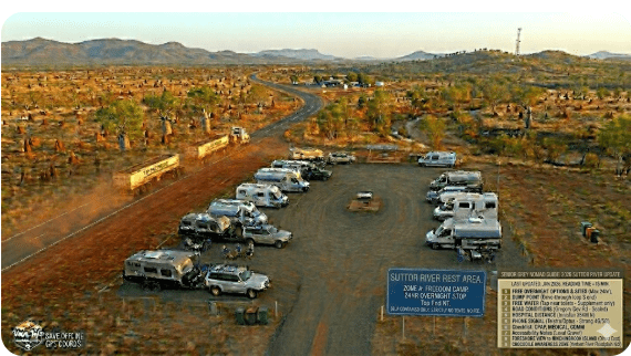
4. Suttor River Rest Area: Full Facilities, GPS and Access Details
| 📍 Suttor River Rest Area — Quick Facts 2026 | |
|---|---|
| Full Name | Suttor River Rest Area |
| Location | Suttor Developmental Road (Collinsville–Elphinstone Road), Queensland |
| GPS | -21.1050, 147.7730 (approx — verify in Google Maps before departure) |
| Postcode | 4804 (approximate — remote area) |
| Cost | Free |
| Stay Limit | 20 hours (confirm with TMR — standard Queensland rest area limit) |
| Road Access | ⚠️ Partially unsealed — sealed sections and unsealed sections. Subject to flooding at the Suttor River crossing. |
| Caravans | ✅ Yes — adequate space for standard caravans when dry |
| Big Rigs | ⚠️ Limited — larger rigs can fit but turning space may be tight. Check surface conditions. |
| Toilets | ⚠️ Basic toilet may be present (pit/drop style) — confirm current status. Carry your own toilet supplies. |
| Drinking Water | ❌ No — bring your own. River water is not potable. |
| Mains Power (240V) | ❌ No — CPAP users must carry a lithium battery backup |
| Telstra Reception | ⚠️ Patchy — may get a weak signal with an external antenna. Do not rely on mobile coverage here. Carry a PLB. |
| Optus Reception | ❌ Unlikely — Optus coverage does not typically extend to this area |
| Pets | ✅ Allowed — keep on leash, watch for wildlife and snakes |
| Dump Point | ❌ No on-site dump point. Nearest: Collinsville (~90 km NE) or Glenden (~75 km SW) |
| Nearest Hospital | ⛑️ Collinsville Multi-Purpose Health Service — ~90 km | (07) 4785 6700 |
| Nearest RFDS | RFDS Townsville base covers this region. In emergency, call 000 and request RFDS if needed. |
| Senior Rating | ⭐⭐⭐ — Suitable for one-night fatigue stops by self-contained travellers. Not recommended for extended stays or travellers who need power, water or reliable phone signal. |
The Suttor River Rest Area is a pull-off area beside the Suttor Developmental Road near the river crossing. The ground surface is typically compacted dirt and gravel. When dry, it is firm enough for standard caravans. After rain, the surface can become soft and boggy — particularly close to the river.
There is generally shade from riverside trees (predominantly eucalyptus and paperbarks), which is a genuine advantage in the Bowen Basin heat. Some travellers report picnic tables, but the condition and availability of these can vary — they are not always maintained.
Road Conditions, Flood Risk and Getting to Suttor River Rest Area
Understanding the road to the Suttor River Rest Area is just as important as understanding the rest area itself. This is not a highway stop beside a sealed dual carriageway. The Suttor Developmental Road has characteristics that every senior towing a caravan must know about before committing to this route.
Road Surface — Sealed and Unsealed Sections
The Suttor Developmental Road (officially the Collinsville–Elphinstone Road) runs roughly south-west to north-east, connecting the Bowen Developmental Road near Glenden with Collinsville and ultimately the Bruce Highway. As of 2026, this road has a mix of sealed and unsealed sections. The unsealed sections can be rough, corrugated, and dusty in the dry season. After rain, these sections can become slippery, soft, or impassable.
The sealed sections are generally in reasonable condition but narrow in places — expect single-lane sealed road with gravel shoulders in some stretches. Mining traffic, including heavy vehicles and road trains, uses this road regularly. Be prepared for dust clouds from oncoming vehicles on unsealed sections — slow down, pull left, and give them space.
- Yes. The Suttor River crossing is subject to flooding during and after heavy rain, particularly during the wet season (December–March). When the Suttor River is in flood, this crossing becomes impassable — sometimes for days.
- There are also additional creek crossings and low-lying sections along the Suttor Developmental Road that can be inundated.
- Queensland Department of Transport and Main Roads (TMR) can close this road without warning when flooding occurs. There are no practical detours if you are already committed to this route.
- Before travelling, always check road conditions: Call TMR on 13 19 40 or check the QLDTraffic website for current road closures.
- If you see water over the road — do not cross. “If it’s flooded, forget it” is not just a slogan in Queensland. It is the difference between arriving safely and being swept off the road.
Approaching from the North-East (Collinsville Direction)
From Collinsville, head south-west on the Suttor Developmental Road. The first 30–40 km out of Collinsville is generally sealed and in reasonable condition. As you continue south-west toward the Suttor River, you will encounter sections of unsealed road. The total distance from Collinsville to the Suttor River Rest Area is approximately 90 km, which takes around 1.5 to 2 hours depending on road conditions and your towing speed.
Approaching from the South-West (Glenden Direction)
From Glenden, head north-east on the Suttor Developmental Road (via the Bowen Developmental Road junction). The distance from Glenden to the Suttor River Rest Area is approximately 75 km. Again, expect a mix of sealed and unsealed surfaces. The road passes through cattle country and mining lease areas — watch for cattle on the road, particularly at dawn and dusk.
Approaching from the Bruce Highway (East)
If you are coming from the coast via the Bruce Highway, the most common approach is to turn off at Bowen or Collinsville. From the Bruce Highway turnoff to Collinsville is approximately 85 km on a sealed road. From Collinsville, you then continue south-west on the Suttor Developmental Road as described above. Total distance from the Bruce Highway to the Suttor River Rest Area is approximately 175 km.
Approaching from the West (Charters Towers / Belyando Crossing Direction)
If you are coming from the west — perhaps from Charters Towers via the Flinders Highway and then south on the Gregory Developmental Road — you would need to connect via the Bowen Developmental Road to reach the Suttor Developmental Road. This is a long, remote route through cattle stations and mining country. Distances are significant and fuel planning is critical. This route is covered in the fuel section below.
Fuel Station Distances — North, South, East and West of Suttor River Rest Area
Fuel planning is absolutely critical when travelling the Suttor Developmental Road. There are no fuel stations between Collinsville and Glenden along this road. If you run out of fuel between these two towns, you are stranded in an area with limited phone coverage and no passing traffic guarantee.
| Direction | Nearest Fuel Station | Approx Distance from Suttor River Rest Area | Notes |
|---|---|---|---|
| North-East (Collinsville) | Collinsville — Puma/United or independent fuel outlet | ~90 km | Last reliable fuel before heading south-west. Fill up here. Diesel and unleaded available. |
| South-West (Glenden) | Glenden — local fuel outlet | ~75 km | Mining town. Fuel available but confirm hours — may not be 24hr. Fill up before departing. |
| East (Bruce Highway / Bowen) | Bowen — multiple fuel stations on the Bruce Highway | ~175 km (via Collinsville) | Full range of fuel types. Major highway services available. |
| West (Belyando Crossing / Charters Towers) | Belyando Crossing Roadhouse (if operating — confirm before travel) or Charters Towers | ~150–250+ km depending on route | Very remote route. Confirm fuel availability at any intermediate roadhouses before committing. Carry extra fuel. |
| South (via Bowen Developmental Road toward Moranbah) | Moranbah — multiple fuel stations | ~130–150 km (via Glenden and Peak Downs Highway) | Mining town with full services. Sealed road from Glenden south. |
- There is no fuel available at the Suttor River Rest Area or anywhere along the Suttor Developmental Road between Collinsville and Glenden.
- The minimum gap between fuel is approximately 165 km (Collinsville to Glenden). When towing a caravan, your fuel consumption increases significantly — plan for at least 20–25 litres per 100 km when towing.
- Always fill your fuel tank completely before leaving Collinsville or Glenden. Carry a minimum 20-litre jerry can as emergency backup.
- If heading west beyond Glenden toward Charters Towers, the fuel gaps can exceed 200 km. Do not attempt this without confirming intermediate fuel availability and carrying extra reserves.
5. Is a Permit or Fee Required at Suttor River Rest Area?
No. The Suttor River Rest Area is a Queensland Department of Transport and Main Roads (TMR) rest area. As of 2026, it is free to use with no permit required. The standard Queensland rest area stay limit of 20 hours applies — this is designed to allow an overnight stop for fatigue management, not extended camping.
You do not need a national parks pass or any other permit. There is no self-registration system. You simply pull in, park, rest, and continue your journey.
6. What Suttor River Rest Area Doesn’t Tell You Online
Here are the things that experienced travellers know about this rest area — the details that never appear in the WikiCamps listing or the Google Maps pin:
1. The insects can be relentless. The Suttor River area is home to significant mosquito populations, particularly after rain or during the wet season. Midges (sandflies) can also be a problem near the water. If you are camping here in the warmer months, bring industrial-strength repellent and ensure your caravan’s screens are intact. A mosquito coil or citronella device outside will help.
2. Mining traffic does not stop at night. The Suttor Developmental Road serves mining operations. Heavy vehicles, road trains, and mine buses may pass at any hour. The noise and headlights can disturb light sleepers. If possible, park as far from the road as the rest area allows.
3. Cattle wander into the rest area. This is open range country. Cattle can be found at or near the rest area, particularly near the river. Keep food secured, watch where you step, and be cautious walking dogs near livestock.
4. The river can rise rapidly. Even if the sky above you is clear, rain upstream in the catchment can cause the Suttor River to rise with little warning. If you are camped near the river and notice the water level changing, move your vehicle to higher ground immediately. This is a genuine safety concern during the wet season.
5. You may be the only people there — or there may be 15 vans. During the dry season travel period (April–October), this rest area can be busy with grey nomads. During the wet season, it may be completely empty — and the road may be closed. There is no way to book or check availability. You arrive and see what is there.
7. Van Life Savings Spots — Free and Low-Cost Camping Near Suttor River
If the Suttor River Rest Area is full, flooded, or does not suit your needs, there are alternatives in the broader region. For the full Queensland free camp database — including the ability to ask the AI for GPS to nearby attractions, alternative accommodation, or the next free camp on your route — visit our Van Life Savings Spots App. It is built specifically for senior grey nomads and lets you ask questions like “what is the nearest dump point to Suttor River?” or “find me powered sites near Collinsville tonight” and get back GPS coordinates instantly.
- “What is the nearest free camp to Collinsville QLD with toilets?”
- “Find me a dump point between Glenden and Collinsville”
- “Where is the closest powered caravan park to Suttor River?”
- “Show me free camps along the Bowen Developmental Road”
| Alternative Camp | Distance from Suttor River | Cost | Senior Suitability |
|---|---|---|---|
| Collinsville Showgrounds | ~90 km NE | Low cost — confirm with Whitsunday Regional Council | ✅ Toilets, town water, Telstra coverage, close to hospital. Good senior option. |
| Glenden Rest Area / Town Park | ~75 km SW | Free or low cost (confirm with Isaac Regional Council) | ⚠️ Small mining town. Basic facilities. Fuel available. Limited services outside mine shifts. |
| Bowen — Queens Beach free camping area | ~175 km E (via Collinsville) | Free (self-contained vehicles only — 48hr limit) | ✅ Coastal location. Toilets nearby. Telstra coverage. Hospital in Bowen. Good senior option if coming from the coast. |
7b. Dump Points on Your Route — GPS Before and After Suttor River
| Direction | Dump Point Location | Approx Distance | GPS |
|---|---|---|---|
| On Site | ❌ No dump point at Suttor River Rest Area | — | — |
| North-East (Before — if coming from Collinsville) | Collinsville dump point — confirm location with Whitsunday Regional Council (07) 4945 4200 | ~90 km | -20.5530, 147.8430 (approx — verify in Google Maps) |
| South-West (After — heading toward Glenden) | Glenden — confirm dump point availability with Isaac Regional Council (07) 4879 3000 | ~75 km | -21.3490, 147.8430 (approx — verify in Google Maps) |
| South (Moranbah) | Moranbah dump point — confirm with Isaac Regional Council | ~130–150 km via Glenden | -22.0010, 148.0470 (approx — verify in Google Maps) |
- Never use a dump point rinse hose for drinking water — these are contaminated with wastewater residue.
- Allow extra time during peak travel season (May–August) — dump points at small towns can have queues of grey nomad vans.
- If you have a cassette toilet, empty it at every opportunity. The next dump point on remote routes may be 100+ km away.
- Confirm dump point locations with the relevant Shire/Council before travel — some dump points in small mining towns are relocated or temporarily closed.
7c. Free Potable Water Locations — GPS Before and After Suttor River
| Direction | Water Source | Approx Distance | Status |
|---|---|---|---|
| On Site | ❌ No potable water at Suttor River Rest Area. River water is not safe for drinking. | — | ❌ Bring your own |
| North-East (Collinsville) | Collinsville — town water available at caravan park, showgrounds, or public taps | ~90 km | ✅ Town mains water. Fill tanks before departing. |
| South-West (Glenden) | Glenden — town water available (confirm tap location with Council) | ~75 km | ✅ Town mains water. Fill tanks before departing. |
- Carry at least two full days of emergency drinking water reserves beyond your planned daily use. In this region, if the road floods, you could be stranded at the rest area for 24–72 hours.
- Never fill your water tanks from an unmarked tap — it may be bore water, recycled water, or non-potable stock water.
- The Suttor River water is not safe for drinking, even with a portable filter, due to agricultural runoff and livestock contamination.
- In summer, your water consumption will increase dramatically. Plan for at least 5 litres per person per day in the Bowen Basin heat.
8. Collinsville or Glenden as Your Alternative Base: The Smarter Senior Option
If you need powered sites, reliable phone signal, access to a hospital, a dump point, or simply the comfort of knowing help is nearby — then Collinsville or Glenden are your logical alternatives to the Suttor River Rest Area.
Collinsville (~90 km NE of Suttor River Rest Area)
Collinsville is a former coal mining town with a population of approximately 1,500. It has a supermarket, fuel, a hospital (Collinsville Multi-Purpose Health Service), and accommodation options including a caravan park. For seniors, Collinsville is the smarter choice if you need any services at all. The Collinsville Caravan Park offers powered and unpowered sites. The town also has the Collinsville Showgrounds, which may offer low-cost camping — confirm with Whitsunday Regional Council on (07) 4945 4200.
Glenden (~75 km SW of Suttor River Rest Area)
Glenden is a small mining town built to service the Hail Creek Mine. It has a small population, a general store, fuel, and limited facilities. There is no hospital in Glenden — the nearest is Collinsville or Moranbah. Glenden can work as an overnight stop if you are heading south-west toward Moranbah or the Peak Downs Highway, but it has fewer services than Collinsville. Confirm camping options with Isaac Regional Council on (07) 4879 3000.
9. Full Facilities Comparison: Suttor River Rest Area vs Collinsville vs Glenden
| Facility | Suttor River Rest Area | Collinsville | Glenden |
|---|---|---|---|
| Cost | Free | $30–$40/night (powered — confirm) | Low cost or free (confirm with Council) |
| 240V Power | ❌ | ✅ | ⚠️ Confirm availability |
| Toilets / Showers | ⚠️ Basic / ❌ | ✅ / ✅ | ⚠️ / ⚠️ Confirm |
| Dump Point | ❌ | ✅ | ⚠️ Confirm with Council |
| Hospital | ~90 km (Collinsville) | In town ✅ | ❌ Nearest: Collinsville or Moranbah |
| Telstra Signal | ⚠️ Patchy | ✅ Good | ✅ Reasonable |
| Fuel | ❌ | ✅ | ✅ |
| Supermarket | ❌ | ✅ Small supermarket | ⚠️ General store only |
| Pets | ✅ | ✅ Confirm with park | ✅ Confirm with Council |
10. Rates: All Options Near Suttor River
| Option | Cost per Night (2026) |
|---|---|
| Suttor River Rest Area | Free (20-hour limit) |
| Collinsville Caravan Park (powered site) | Approx $30–$40 — confirm direct with park |
| Collinsville Showgrounds (if open to campers) | Low cost — confirm with Whitsunday Regional Council |
| Glenden camping options | Free or low cost — confirm with Isaac Regional Council |
| Bowen — Queens Beach free camping | Free (self-contained, 48-hour limit) |
11. The Suttor River Day Plan for Seniors
The Suttor River Rest Area is not a destination — it is a transit stop. Here is the recommended plan for senior travellers using this rest area:
Late Afternoon (3:00–5:00 PM): Arrive at the rest area well before dark. Choose a level spot away from the road. Set up camp while there is still daylight to check the ground surface, look for ant nests, and ensure you are not parked in a drainage channel.
Evening (5:00–7:00 PM): Enjoy the sunset over the outback — the Bowen Basin landscape is remarkably beautiful at dusk. Cook dinner using your own supplies. Apply insect repellent liberally. If other travellers are present, enjoy the camaraderie — rest area conversations are one of the genuine pleasures of grey nomad travel.
Night: Lock your vehicle. Keep a torch within reach. If you hear cattle near your van, it is normal — they are curious, not threatening.
Early Morning (5:30–7:00 AM): Depart early to take advantage of cool temperatures. The Bowen Basin can exceed 40°C in summer by mid-morning. If you are heading to Collinsville, the drive is approximately 1.5–2 hours. If heading to Glenden, approximately 1–1.5 hours.
12. Senior Checklist — Suttor River Rest Area Stop
| ☐ | Checklist Item |
|---|---|
| ☐ | Check road conditions before departure: call TMR on 13 19 40 or check QLDTraffic |
| ☐ | Fill fuel tank completely at Collinsville or Glenden before departing |
| ☐ | Carry minimum 20-litre jerry can of emergency fuel |
| ☐ | Top up drinking water tanks at Collinsville or Glenden — no potable water at Suttor River |
| ☐ | Carry minimum 2 days emergency drinking water reserves (10 litres per person) |
| ☐ | CPAP battery fully charged — no mains power at rest area |
| ☐ | PLB (Personal Locator Beacon) packed and registered — phone signal unreliable |
| ☐ | Insect repellent and fly net for face/head |
| ☐ | First aid kit checked and stocked — antihistamines, bandages, pain relief |
| ☐ | Torch with fresh batteries — no lighting at rest area |
| ☐ | Tyre pressure checked — lower slightly for unsealed sections (re-inflate on sealed road) |
| ☐ | Wheel nuts checked and tightened |
| ☐ | Save dump point GPS BEFORE Suttor River — Collinsville dump point | GPS: -20.5530, 147.8430 (approx) |
| ☐ | Save dump point GPS AFTER Suttor River — Glenden | GPS: -21.3490, 147.8430 (approx) |
| ☐ | Save hospital details: Collinsville MPHS — (07) 4785 6700 — ~90 km NE |
13. What to Do Near Suttor River: Your Senior Day Plan
The Suttor River Rest Area is in a remote location with limited nearby attractions. This is cattle and mining country, not a tourist precinct. However, if you are spending time in the broader region, here are some options:
Collinsville Coal and History Museum (~90 km NE): A small local museum documenting the coal mining history of the region. Flat access, air-conditioned, suitable for seniors. Confirm opening hours with the Collinsville Information Centre.
Bowen Murals and Foreshore (~175 km E via Collinsville): Bowen is famous for its mural trail — over 25 murals depicting the town’s history. The foreshore walk is flat, paved, and accessible. Toilets available. Excellent for seniors. Also home to the “Big Mango” — a photographic landmark.
Lake Elphinstone (~50–60 km S of Suttor River): A natural freshwater lake popular for bird watching and fishing. Access roads may be unsealed — check conditions. Toilet facilities may be basic. Senior access depends on conditions at time of visit. Confirm current status with Isaac Regional Council.
Eungella National Park (~200 km NE via Collinsville and the coast road): Famous for wild platypus viewing at Broken River. Sealed road access. Wheelchair-accessible viewing platform. This is a genuine highlight of the region, but it is a full day trip from the Suttor River. Worth the detour if you are heading to the coast. Note: national parks rules apply — no pets.
14. GPS Coordinates and Postcodes: Save Every Stop
Save these coordinates to your phone or GPS device before you travel. Every location mentioned in this article is listed below. All approximate coordinates should be verified in Google Maps before departure.
| Location | Postcode | GPS (Latitude, Longitude) | Notes |
|---|---|---|---|
| 📍 Suttor River Rest Area | 4804 | -21.1050, 147.7730 (approx — verify in Google Maps) | Main subject of this guide. Suttor Developmental Road. |
| ⛑️ Collinsville Multi-Purpose Health Service | 4804 | -20.5510, 147.8450 (approx — verify in Google Maps) | Nearest hospital. ~90 km NE. (07) 4785 6700 |
| 📍 Collinsville Caravan Park | 4804 | -20.5530, 147.8430 (approx — verify in Google Maps) | Powered sites, showers, dump point. ~90 km NE. |
| 📍 Collinsville Showgrounds | 4804 | -20.5520, 147.8450 (approx — verify in Google Maps) | Possible low-cost camping. Confirm with Council. |
| 📍 Glenden | 4743 | -21.3490, 147.8430 (approx — verify in Google Maps) | Mining town. Fuel available. ~75 km SW. |
| 📍 Bowen (Bruce Highway) | 4805 | -20.0100, 148.2410 (approx — verify in Google Maps) | Full services. Fuel, hospital, free camping at Queens Beach. ~175 km E via Collinsville. |
| 📍 Moranbah | 4744 | -22.0010, 148.0470 (approx — verify in Google Maps) | Mining town. Full services, fuel, hospital. ~130–150 km S via Glenden. |
| 🗑️ Dump Point — Collinsville (NE — before Suttor River) | 4804 | -20.5530, 147.8430 (approx — verify in Google Maps) | Confirm exact location with Whitsunday Regional Council. |
| 🗑️ Dump Point — Glenden (SW — after Suttor River) | 4743 | -21.3490, 147.8430 (approx — verify in Google Maps) | Confirm with Isaac Regional Council. |
| 💧 Potable Water — Collinsville (NE) | 4804 | -20.5530, 147.8430 (approx — verify in Google Maps) | Town mains water. Fill tanks before departing. |
| 💧 Potable Water — Glenden (SW) | 4743 | -21.3490, 147.8430 (approx — verify in Google Maps) | Town mains water. Fill tanks before departing. |
Public WiFi: There is no public WiFi available at the Suttor River Rest Area. The nearest public WiFi is likely available at the Collinsville Library or a café in Collinsville (~90 km NE). Bowen also has public WiFi at its library and some foreshore locations.
15. Frequently Asked Questions — Suttor River Rest Area for Grey Nomads
Is Suttor River Rest Area free to camp at?
Yes. The Suttor River Rest Area is a Queensland Department of Transport and Main Roads rest area and is free to use. No permit is required. The standard rest area stay limit of 20 hours applies.
Can I take a caravan to Suttor River Rest Area?
Yes, standard caravans can access the Suttor River Rest Area when the road is dry. However, the Suttor Developmental Road has unsealed sections that can be rough or impassable after rain. Check road conditions with TMR on 13 19 40 before you travel.
Does the road to Suttor River Rest Area flood?
Yes. The Suttor Developmental Road crosses the Suttor River, and this crossing is subject to flooding during and after heavy rain, particularly during the wet season (December–March). The road can be closed for days. Always check current conditions before travelling.
Is the road to Suttor River Rest Area sealed or unsealed?
The Suttor Developmental Road is a mix of sealed and unsealed sections. Expect some rough, corrugated gravel road. Reduce speed when towing on unsealed sections and carry a tyre repair kit.
Is there phone signal at Suttor River Rest Area?
Telstra may provide a weak, patchy signal — but do not rely on it. Optus coverage is unlikely. Carry a registered Personal Locator Beacon (PLB) for emergencies. An external antenna (such as a Cel-Fi Go) may improve Telstra reception.
Can I use a CPAP machine at Suttor River Rest Area?
There is no mains power at this rest area. CPAP users must carry a lithium battery backup that can run their machine for a full night. Test your battery setup at home before relying on it in the outback.
Where is the nearest hospital to Suttor River Rest Area?
The nearest hospital is the Collinsville Multi-Purpose Health Service, approximately 90 km north-east. Phone: (07) 4785 6700. In a medical emergency, call 000 — RFDS covers this region from the Townsville base.
Where is the nearest fuel to Suttor River Rest Area?
The nearest fuel is in Collinsville (~90 km NE) or Glenden (~75 km SW). There is no fuel available along the Suttor Developmental Road between these two towns. Always fill your tank completely before leaving either town.
Are dogs allowed at Suttor River Rest Area?
Yes, pets are allowed at the rest area. Keep your dog on a leash and be aware of wildlife, snakes, and wandering cattle in the area. There are no dog-specific facilities.
Is there drinking water at Suttor River Rest Area?
No. There is no potable water at this rest area. You must carry all your own drinking water. The Suttor River water is not safe for drinking due to agricultural and livestock contamination. Fill your tanks at Collinsville or Glenden before arriving.
Is there a dump point at Suttor River Rest Area?
No. The nearest dump points are in Collinsville (~90 km NE) and potentially Glenden (~75 km SW). Confirm availability with the relevant council before travel.
How long can I stay at Suttor River Rest Area?
The standard Queensland rest area stay limit is 20 hours. This is designed for overnight fatigue stops, not extended camping. If you want to stay longer in the area, move on to a formal campground or caravan park in Collinsville or Glenden.
16. Quick-Reference Card + Booking Options
- Suttor River Rest Area: Suttor Developmental Road, QLD 4804 | GPS: -21.1050, 147.7730 (approx) | Free | 20-hour limit
- Nearest Hospital: Collinsville MPHS — ~90 km NE | (07) 4785 6700
- Road Conditions: TMR: 13 19 40 | qldtraffic.qld.gov.au
- Nearest Fuel NE: Collinsville (~90 km)
- Nearest Fuel SW: Glenden (~75 km)
- Emergency: Call 000. RFDS Townsville base covers this region. Carry a registered PLB.
The Suttor River Rest Area is a genuine, functional free camping spot for self-contained grey nomads who are prepared for basic outback conditions. It is not for everyone. If you need power, water, phone signal or proximity to a hospital, continue to Collinsville. But if you are experienced, self-contained, and looking for a safe place to break a long drive through the Bowen Basin — this rest area does the job.
For more free camping options across Australia, explore our Van Life Savings Spots database, and for route planning across Queensland and beyond, see our complete grey nomad driving routes guide.
Disclaimer: Suttor River Rest Area information is provided in good faith based on publicly available data as of early 2026. Facilities, rules, and access can change without notice. Always verify current conditions with Queensland Department of Transport and Main Roads (TMR) on 13 19 40, Whitsunday Regional Council on (07) 4945 4200, or Isaac Regional Council on (07) 4879 3000 before travelling. GPS coordinates are sourced from publicly available mapping data — verify against your preferred navigation app before departure. Medical facility details should be confirmed before travel. This article does not constitute medical or travel safety advice. Carry appropriate insurance, a registered PLB, and emergency equipment when travelling remote Australia.
Free campsites fill fast during school holidays and peak season. If your preferred site is too busy or doesn’t suit your needs, search remaining accommodation options below.
Accommodation and flight search powered by Expedia. Booking through this search supports this website at no extra cost to you. As an affiliate, I earn from qualifying purchases at no extra cost to you.

As an affiliate, I earn from qualifying purchases at no extra cost to you.