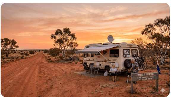
Queensland Free Camping Guide 2026
A comprehensive, definitive master guide to free and low-cost camping across Queensland for senior grey nomads — covering all regional town directories, road sealing, flood risks, fuel ranges, crocodile safety, medical access, and practical arrival expectations for 2026.
📅 Last reviewed: July 2026 | Queensland QLD — State-wide | Rules, access and facilities vary significantly by region, council and land manager — always verify locally before arrival
Queensland is the heartland of grey nomad travel in Australia. Every winter, tens of thousands of senior travellers migrate north in caravans and motorhomes, drawn by warm temperatures, vast outback landscapes, tropical coastline and some of the most generous free camping access of any Australian state. From the Gold Coast hinterland to Cape York, from the Channel Country to the Coral Sea coast, Queensland offers a free camping network that rewards those who plan carefully. But the state’s sheer size, climate variability, remote access roads and inconsistent facilities mean that preparation is everything. This unified master guide gives you the complete, honest picture — region by region, town by town.
- State: Queensland (QLD)
- Best free camping regions: Outback QLD, Cape York, Savannah Way, Sunshine Coast hinterland, Gulf Country, Darling Downs, Wide Bay & Fraser Coast
- Peak season for grey nomads: May to September (dry season, mild temperatures)
- Avoid: November to March in the north and outback (wet season, road closures, extreme heat)
- Toilets: Present at many council and QPWS sites — absent at most informal stops
- Dump points: Available in major regional towns — not at roadside rest areas
- Potable water: Unreliable at free stops — always carry your own supply
- Power: No power at free camping areas — solar and battery essential
- Phone signal: Telstra best. Optus reasonable on the coast. Minimal coverage in outback and Cape York.
- Key booking system: Queensland Parks and Wildlife Service (QPWS) — book online at parks.des.qld.gov.au
- Free camp app: WikiCamps and Campermate — essential for Queensland trip planning
Table of Contents
- Queensland free camping regions — location and GPS overview
- Can you camp free in Queensland? Rules and legal overview
- Crocodile safety — the rule that applies north of Rockhampton
- Facilities: toilets, water, bins and dump points across Queensland
- Mobile coverage and public Wi-Fi across Queensland
- Far North Queensland — Cairns, Port Douglas and the Tablelands
- Whitsundays and Mackay Coast Corridor
- North Queensland — Townsville to Bowen and Tully
- Central Queensland — Rockhampton Hospital Access and Inland
- Wide Bay and Fraser Coast — Nine Town Directories
- South-East Queensland Gateway Towns
- Outback Queensland — Inland Routes
- Best time of year to camp free in Queensland
- Top 10 senior-specific tips for Queensland free camping
- Fires, generators and overnight etiquette in Queensland
- Medical and emergency contacts across Queensland
- Packing checklist for seniors in Queensland
- GPS coordinates and postcodes — save every key stop
- Frequently Asked Questions (Including solo senior safety & rest area vs campground)
- Quick verdict — is Queensland worth it for grey nomads?
- Queensland rest areas and free camping — GPS links by region
📵 Before You Set Up Camp: Can 000 Find You Here?
Most rest areas don’t have a street address. If something goes wrong overnight, “I’m at a rest stop somewhere past the servo” wastes precious minutes. Before you unhitch, open Emergency+ and check it can pin your GPS location or generate a what3words address right where you’re parked — it works offline, so no signal doesn’t mean no location. Get it free — iPhone (App Store) or Android (Google Play).
The habit that matters: do this the moment you arrive, not if you need it. Signal drops in and out at bush camps — testing it early means you already know it works before an emergency makes that the wrong time to find out.
Bonus use: while you’re in the app, grab the GPS coordinates it shows you and save them to your own Van Life Savings Spots pin — a good stop is worth remembering for next time, and now you’ve already got the exact coordinates in hand.
Section 1 — Queensland Free Camping Regions: Location and GPS Overview
Queensland is Australia’s second-largest state, covering 1,852,642 square kilometres. For grey nomads, it divides naturally into distinct camping regions, each with its own character, access requirements and seasonal window. The following overview covers the primary free camping regions used by senior travellers, with GPS reference points for navigation planning.
📍 GPS Reference — Outback Queensland Hub (Longreach)
Longreach QLD 4730 — central outback Queensland navigation reference. Qantas Founders Museum and major services.
📍 GPS Reference — Cape York Gateway (Cairns)
Cairns QLD 4870 — northern Queensland hub. Starting point for Cape York Peninsula access and Savannah Way.
📍 GPS Reference — Gulf Country Hub (Mount Isa)
Mount Isa QLD 4825 — western Queensland hub. Gateway to Gulf of Carpentaria and Savannah Way westbound.
Section 2 — Can You Camp Free in Queensland? Rules and Legal Overview
Yes — Queensland has an extensive network of legitimate free and low-cost camping areas. However, the rules governing where you can camp, for how long, and under what conditions vary significantly depending on who manages the land.
The four main land management categories in Queensland
- Queensland Parks and Wildlife Service (QPWS) sites: Managed national park and state forest camp areas. Many require a booking and a small fee ($6–$8 per person per night). Booking is done online at parks.des.qld.gov.au. Do not arrive unbooked at QPWS sites — rangers enforce booking requirements and issue fines.
- Local council rest areas and free camps: Many Queensland councils operate designated free camping areas for grey nomads — often with toilets, dump points and time limits (typically 48–72 hours). Rules and facilities vary enormously by council — check local council websites or use Campermate for recent reports.
- State-managed roadside rest areas: Transport and Main Roads QLD operates highway rest areas for driver fatigue stops. These permit overnight stays for safety purposes but impose a 20-hour maximum stay.
- Private property and farmstay: Requires explicit landowner permission. Never assume that pulling off onto a farm track or station road is permitted.
Section 3 — Crocodile Safety — The Rule That Applies North of Rockhampton
🐊 Crocodile Safety — Read This Before You Camp Near Any Water North of Rockhampton
Saltwater crocodiles are present in all tidal waterways, estuaries, rivers, creeks, lakes and dams north of approximately Rockhampton on Queensland’s east coast and across the entire Gulf and Cape York regions. This is a documented, active danger that kills and seriously injures people every year.
- Never swim in any waterway north of Rockhampton unless it is a clearly signed, actively managed swimming area.
- Never wash dishes, clean fish, or rinse gear at the water’s edge. Crocodiles associate food preparation smells with prey. Carry a washing bucket and work away from the waterline.
- Never approach the water’s edge after dark. Saltwater crocodiles are significantly more active at night and in low-light conditions.
- Keep at least 5 metres from the water’s edge at all times when setting up camp or walking around a riverside site.
- Do not let pets near waterways. Dogs are particularly vulnerable — a crocodile will take a dog at the water’s edge without warning. Keep pets on leads.
- Check current warning signs on arrival at every site near water. QPWS posts warning signs at known crocodile sites — but absence of a sign does not mean absence of crocodiles.
- Report crocodile sightings immediately to Queensland Parks and Wildlife Service on 1300 130 372.
Section 4 — Facilities: Toilets, Water, Bins and Dump Points Across Queensland
Facility quality across Queensland’s free camping network varies enormously by region and managing authority. Always carry a portable toilet and independent water reserves.
- Toilets: Present at better council and QPWS sites; absent at roadside rest areas and informal bush camps. Confirm presence via WikiCamps or QPWS confirmation.
- Potable Water: Unreliable at free camps. Carry a minimum 40 litres per person for outback legs.
- Dump Points: Located in major towns (Cairns, Townsville, Mackay, Rockhampton, Bundaberg, Hervey Bay, Gympie, Longreach, Mount Isa). Never discharge grey water on the ground.
- Bins: Pack it in, pack it out at locations without confirmed bin access.
Section 5 — Mobile Coverage and Public Wi-Fi Across Queensland
Telstra provides the most extensive regional and outback Queensland coverage by a significant margin. Optus and Vodafone coverage drops dramatically west of the Bruce Highway. Portable Starlink is increasingly popular among long-term grey nomads for reliable outback and Gulf connectivity. Regional libraries and McDonald’s outlets offer public Wi-Fi in larger towns.
Section 6 — Far North Queensland — Cairns, Port Douglas and the Tablelands
Far North Queensland is the tropical crown jewel of the grey nomad circuit, delivering lush rainforests, waterfalls, and a relaxed tropical pace. Tropical humidity can be intense outside the dry season, and crocodile safety rules must be observed at every waterway.
Free Camping Cairns — Retiree Guide
Comprehensive retire-friendly guide to free camping in Cairns and Far North QLD. Covers verified overnight stops, council rules, and facilities.
Full Guide →Free Camping for Couples — Cairns and Port Douglas
Quiet, spacious roadside and council spots tailored for couples travelling in caravans and motorhomes through the tropical north.
Full Guide →Pet-Friendly Free Camping Cairns QLD
Travelling with a dog through tropical North Queensland? Verified pet-friendly free camps around Cairns with shade, secure parking, and exercising areas.
Full Guide →Pet-Friendly Free Camping Port Douglas QLD
Shaded overnight spots and pet-friendly rest stops near Port Douglas, Four Mile Beach, and the Daintree rainforest gateway.
Full Guide →Section 7 — Whitsundays and Mackay Coast Corridor
The Whitsundays and Mackay coast corridor along the Bruce Highway offers sugarcane country, island gateways, coastal boardwalks, and well-maintained council rest areas.
Grey Nomad Free Camping Near Airlie Beach QLD
Verified free and low-cost overnight stops near Airlie Beach and Shute Harbour ferry terminals. Avoid coastal fines with our GPS-verified grey nomad guide.
Full Guide →Free Camping Mackay
Coal coast city — complete free camping and rest area guide for seniors near Mackay, Pioneer River, and northern beaches.
Full Guide →Free Camping Proserpine QLD
Inland sugar town with great retiree overnight options, dump points, local markets, and easy Bruce Highway access.
Full Guide →Section 8 — North Queensland — Townsville to Bowen and Tully
Stretching from Townsville up through Bowen, Home Hill, Ayr, and Tully, North Queensland presents a dramatic coastal landscape framed by sugar cane fields, historic country pubs, and pristine national park reserves.
Free Camping Bowen QLD
Explore Bowen’s famous beaches, murals, and fishing spots with our retiree-friendly free camping guide covering overnight rules and coastal rest stops.
Full Guide →Free Camping Home Hill QLD
Burdekin River region stopover guide. Facilities, maximum stay limits, and senior safety notes for self-contained caravans and motorhomes.
Full Guide →Free Camping with Toilets — Tully QLD
Wettest town in Australia with lush green rainforest views. Verified free camping spots featuring toilet facilities and easy highway access.
Full Guide →Section 9 — Central Queensland — Rockhampton Hospital Access and Inland
Central Queensland anchors the state’s beef industry and spans from the Capricorn Coast out to Emerald, Blackall, and Longreach. Rockhampton serves as the pivotal medical and logistical gateway where the tropical north transitions into the southern subtropical zone.
Free Camping Near Hospitals — Rockhampton QLD
Essential medical-proximity guide for grey nomads needing overnight parking or rest stops close to Rockhampton Base Hospital and specialist medical centres.
Full Guide →Section 10 — Wide Bay and Fraser Coast — Nine Town Directories
The Wide Bay and Fraser Coast region — including Bundaberg, Hervey Bay, Rainbow Beach, Tin Can Bay, Gympie, Gunalda, Tiaro, Maryborough, and Childers — is arguably the most popular coastal retiree region in Queensland. Calm waters, incredible whale watching at Hervey Bay, direct access to Fraser Island (K’gari), and an extensive network of welcoming council free camps make this a mandatory stop for every grey nomad.
Free Camping Bundaberg
Rum capital and grey nomad favourite — complete free camping guide for Bundaberg, Bargara, and surrounding coastal river spots.
Full Guide →Free Camping Hervey Bay
Whale watching capital of Australia — complete retiree-friendly free camping guide covering coastal esplanades and hinterland rest areas.
Full Guide →Free Camping Rainbow Beach
Gateway to Fraser Island — complete retiree-friendly free camping guide with GPS coordinates and 4WD access notes.
Full Guide →Free Camping Tin Can Bay
Dolphin feeding and calm waters — retiree-friendly free camping guide for self-contained vans and motorhomes.
Full Guide →Free Camping Gympie
Gold mining heritage town on the Bruce Highway. Shaded council rest areas, dump points, and senior-friendly overnight stops.
Full Guide →Free Camping Gunalda
Quiet rural rest stop north of Gympie. Ideal overnight pull-off for self-contained travellers seeking a peaceful country sleep.
Full Guide →Free Camping Tiaro
Mary River historic town offering convenient Bruce Highway overnight parking, parklands, and local bakery amenities.
Full Guide →Free Camping Maryborough
Historic port city on the Mary River. Heritage walks, riverfront rest areas, and full RV support services.
Full Guide →Free Camping Childers
Red soil hinterland town with historic timber streetscapes, coffee stops, and designated overnight vehicle areas.
Full Guide →Section 11 — South-East Queensland Gateway Towns
South-East Queensland — spanning the Sunshine Coast hinterland, Brisbane surrounds, Scenic Rim, and Gold Coast hinterland — is densely populated and highly regulated. Free camping in this zone is significantly more restricted than in regional Queensland. Plan overnight stops in advance using WikiCamps.
Section 12 — Outback Queensland — Inland Routes
The outback is where Queensland truly expands. Following the Matilda Highway, Warrego Highway, and Savannah Way through Longreach, Winton, Cloncurry, and Mount Isa exposes travellers to immense open skies, dinosaur trails, and welcoming country communities. Support local towns by buying fuel and groceries locally in return for hospitality.
Section 13 — Best Time of Year to Camp Free in Queensland
| Season | What It Is Like | Senior Verdict |
|---|---|---|
| Summer (Dec–Feb) | Extreme heat and humidity in the north and outback. Wet season in northern and central QLD — widespread flooding, road closures and inaccessible camps. Cyclone risk in northern coastal areas. | Avoid northern and outback Queensland entirely. Southeast QLD is manageable but busy and expensive. Most grey nomads head south. |
| Autumn (Mar–May) | The wet season ends progressively from south to north. March–April still carries flood risk in far north QLD. By May, dry conditions are established. | Excellent from May onward — start of peak grey nomad season. April good for southeast and Darling Downs. |
| Winter (Jun–Aug) | Ideal conditions across most of Queensland. Mild to warm days (20–28°C), cool nights (8–15°C), dry and clear in the north. Peak grey nomad season. | Best season overall for the full Queensland experience. Book QPWS sites well in advance. Arrive early at popular council camps. |
| Spring (Sep–Nov) | Temperatures begin rising from September. October and November bring increasing heat in outback and north. Wet season begins in far north from late November. | September and October are good for outback before heat builds. Cape York tracks close from late October. |
Section 14 — Top 10 Senior-Specific Tips for Queensland Free Camping
- Arrive early at popular coastal camps: In peak season (June–August), prime council free camps along the Fraser Coast and Cairns coastal strip often fill by 1:00 PM to 2:00 PM.
- Carry a portable chemical toilet: Ensures you meet strict council self-containment requirements at unserviced coastal and river camps.
- Download offline maps: Use Google Maps offline mode or Hema Explorer before losing mobile coverage.
- Keep a dedicated jerry can of fuel: Outback service stations can be 250km+ apart. Maintain a 20% fuel reserve west of the Bruce Highway.
- Inspect tree branches before parking: Avoid parking under overhanging eucalyptus (“widowmakers”) that drop limbs without warning.
- Join the grey nomad community network: Camp kitchen noticeboards and visitor centres are goldmines for up-to-date road conditions.
- Carry a personal locator beacon (PLB): Essential for Cape York, Gulf Savannah, and deep Matilda Highway travel.
- Establish a daily check-in routine: Set a fixed morning or evening check-in time with family when travelling remote stretches.
- Respect local fire bans absolutely: Queensland fire restrictions carry heavy fines. Extinguish all open flames when bans apply.
- Support local country businesses: Buy your bread, meat, fuel, and meals locally to thank communities for keeping rest areas open.
Section 15 — Fires, Generators and Overnight Etiquette in Queensland
- Open fires: Prohibited at all QPWS national park sites unless a fire ring is provided. Check QFES website for total fire ban status.
- Generators: Not permitted at QPWS national park and state forest camp sites. At council camps, check specific signage. Quiet hours typically 8pm to 8am.
- Noise: Keep music, television and generator noise at low levels after 9pm regardless of location.
- Wildlife: Do not feed wildlife anywhere in Queensland to prevent habituation and culling.
- Rubbish: Pack it in, pack it out at any location without confirmed bin access.
- Grey water: Never discharge grey water or black water onto the ground. Dispose at designated dump points only.
Section 16 — Medical and Emergency Contacts Across Queensland
- Emergency Services: Dial 000 (Use Emergency+ app for GPS coordinates)
- Royal Flying Doctor Service (RFDS) QLD: 1300 669 569
- Healthdirect Australia: 1800 022 222 (24/7 nurse advice)
- Cairns Hospital: (07) 4226 0000
- Townsville University Hospital: (07) 4433 1111
- Rockhampton Base Hospital: (07) 4920 2111
- Longreach Hospital: (07) 4658 1500
Section 17 — Packing Checklist for Seniors in Queensland
| Item | Why It Matters in Queensland | ☐ |
|---|---|---|
| Registered PLB | Essential for Cape York, outback and Gulf Country travel — no mobile coverage for hundreds of kilometres. Must be registered with AMSA before departure. | ☐ |
| Satellite messenger (Garmin inReach or equivalent) | Strongly recommended for solo travellers and all Cape York and Gulf Country routes — provides two-way communication and GPS tracking where mobile coverage is absent. | ☐ |
| 40+ litres potable water per person | Water is a survival issue in outback and Cape York Queensland — distances between confirmed water sources can exceed 300km. | ☐ |
| Fuel jerry cans (20–40 litres reserve) | Fuel stops on outback routes can be 200–300km apart — and occasionally closed. A 20% fuel reserve is the minimum safe margin. | ☐ |
| Quality insect repellent (DEET-based) | Mozzies, sandflies and March flies are intense in tropical, coastal and outback QLD — particularly near water and at dusk and dawn. Ross River Fever risk is real. | ☐ |
| Stinger suit or rashguard (northern QLD) | Marine stingers are present in northern QLD coastal waters October to May. A full-body lycra stinger suit is required for ocean swimming in stinger season. | ☐ |
| Solar system (200W+ panels, 100Ah+ lithium battery) | No power at free camps. Queensland’s solar resource is excellent — a well-sized system fully covers CPAP, device charging and LED lighting needs. | ☐ |
| Cooling system (12V fan, evaporative cooler or reverse cycle) | Even in the dry season, Queensland can deliver 35°C+ days — particularly in the outback from August onward. Heat illness risk for seniors in enclosed vans is real. | ☐ |
| QPWS booking confirmation (printed and digital) | Rangers at national park sites check bookings. No booking confirmation means no entry at QPWS sites during peak season. | ☐ |
| Hema Explorer app (offline Queensland maps) | Covers outback tracks, station roads and Cape York routes not available on Google Maps. Download offline maps for your full Queensland route before leaving coverage. | ☐ |
| Snake bite bandages (compression bandages) | Queensland has significant snake populations — particularly in outback and bushland areas. Pressure immobilisation bandages are the correct first response to any snake bite. Carry at least four. | ☐ |
| Crocodile awareness signage familiarity | Know what current crocodile warning signs look like and treat them as absolute. Never approach, swim near or camp at the water’s edge in northern Queensland waterways. | ☐ |
COPY PROMPT ➔ ASK AI ➔ SAVE TO FORM ➔ ADD SPOT PIN ➔ GET DIRECTIONS
📍 Interactive map — find free camps, rest areas and overnight stops across Queensland. Enable location for best results.
Section 18 — GPS Coordinates and Postcodes: Save Every Key Stop
Save these coordinates to your GPS or phone before leaving mobile coverage. Queensland’s distances between services make offline GPS references essential — do not rely on live navigation in outback, Cape York or Gulf Country regions.
| Location | Address + Postcode | GPS | Notes |
|---|---|---|---|
| Longreach (Outback Hub) | Eagle Street, Longreach QLD 4730 | -23.4422° S, 144.2500° E | Fuel, groceries, dump point, Qantas Founders Museum, hospital |
| Cairns (North QLD Hub) | Sheridan Street, Cairns QLD 4870 | -16.9186° S, 145.7781° E | Full services, Cairns Hospital, QPWS booking centre, Cape York gateway |
| Mount Isa (Western QLD Hub) | Camooweal Street, Mount Isa QLD 4825 | -20.7256° S, 139.4927° E | Fuel, hospital, dump point, Savannah Way junction |
| Hervey Bay (SE QLD Coast) | Boat Harbour Drive, Hervey Bay QLD 4655 | -25.2882° S, 152.8346° E | Whale watching, grey nomad hub, full services, dump point |
| Townsville Hospital | 100 Angus Smith Drive, Douglas QLD 4814 | -19.3197° S, 146.7572° E | Major regional hospital — serves north QLD including outback and Gulf Country referrals |
For a comprehensive collection of verified Queensland free camping GPS coordinates and overnight stops, bookmark our Vanlife Savings Spots guide and update your saved stops before each leg of your Queensland trip.
Section 19 — Frequently Asked Questions
Is camping free in Queensland?
Partially. Queensland has a large network of genuinely free camping areas — including many council-operated sites and informal roadside stops — but it also has an extensive QPWS booking system where fees of $6–$8 per person per night apply at national park and state forest sites. The best free camping in Queensland is found at council-operated areas in regional towns, which are often purpose-built for grey nomads and offer toilets and dump points at no cost.
Can caravans and motorhomes stay overnight in Queensland?
Yes — at designated rest areas, council free camps and QPWS booking sites. Queensland has one of the most generous overnight vehicle stop policies of any Australian state. Many regional councils actively encourage grey nomad overnight stays as an economic development strategy. However, roadside rest areas managed by Transport and Main Roads impose a 20-hour maximum stay limit and are intended for fatigue management rather than extended camping.
What are the GPS coordinates for key Queensland free camping areas?
Key reference GPS coordinates are: Longreach outback hub -23.4422° S, 144.2500° E; Cairns northern hub -16.9186° S, 145.7781° E; Mount Isa western hub -20.7256° S, 139.4927° E; Hervey Bay coastal hub -25.2882° S, 152.8346° E. Individual camp sites within each region have their own specific GPS — use the Campermate or WikiCamps app for individual site coordinates.
Are there toilets at Queensland free camping areas?
At better council and QPWS sites, yes. At roadside rest areas, informal outback stops and bush camps, generally no. Confirm toilet presence at your specific planned stop via a recent Campermate user report (within 30 days) or the QPWS booking site amenity listing before arrival. Carry a portable toilet solution as standard equipment.
Is there a dump point at Queensland free camping areas?
No — there is no dump point at any roadside rest area or informal free camp in Queensland. Dump points are located in major towns throughout the state — Cairns, Townsville, Mackay, Rockhampton, Bundaberg, Hervey Bay, Longreach, Mount Isa and most regional centres. Use the Campermate or Hema Explorer dump point locator to find the nearest option.
Can you get potable water at Queensland free camps?
Not reliably. Some QPWS booking sites and better council camps have potable water on-site. Most roadside rest areas and informal outback stops have no water supply. Fill your fresh water tank at every confirmed town tap before departing for remote areas. In outback Queensland, carry a minimum 40 litres per person.
Is Queensland safe for solo senior grey nomads?
Yes, with appropriate preparation that matches the specific region you are visiting. Coastal Queensland and southeast Queensland are very safe and well-serviced. Outback Queensland, Cape York and Gulf Country require higher preparation — registered PLB, satellite messenger for two-way communication, daily check-in routine with a trusted contact, five-day water and fuel reserves, and clear itinerary sharing before each remote leg. Solo travellers should consider travelling in informal convoy with other grey nomads for Cape York and remote outback legs.
What is the difference between a rest area and a campground in Queensland?
A roadside rest area managed by Transport and Main Roads is primarily designed for driver fatigue management. Stays are strictly capped at 20 hours, facilities are usually limited to a picnic table and bin (sometimes a toilet), and unhitching caravans is generally prohibited. In contrast, council-operated free camps and QPWS campgrounds are legally designated for overnight camping, often allow stays of 48 to 72 hours (or up to 7 nights), permit unhitching, and frequently include water, dump points, and toilet facilities.
What is the nearest hospital for outback Queensland travellers?
For the central outback (Longreach, Winton, Barcaldine): Longreach Hospital, 115 Eagle Street, Longreach QLD 4730, phone (07) 4658 1500. For western Queensland (Mount Isa corridor): Mount Isa Hospital, 30 Camooweal Street, Mount Isa QLD 4825, phone (07) 4744 4444. For northern Queensland (Cairns, Cape York, Gulf access): Cairns Hospital, 165 The Esplanade, Cairns QLD 4870, phone (07) 4226 0000.
Do I need to book Queensland national park campsites in advance?
Yes — for all QPWS national park and state forest booking sites, particularly during peak season (June to August). Popular sites including Carnarvon Gorge, Lawn Hill, Undara, Cape Tribulation and the Whitsundays national park camps book out weeks — sometimes months — in advance. Book online at parks.des.qld.gov.au up to 12 months in advance.
Section 20 — Quick Verdict: Is Queensland Worth It for Grey Nomads?
Queensland is, without question, the premier grey nomad destination in Australia — and it deserves that reputation. The combination of a generous free camping network, extraordinary natural diversity, a genuinely welcoming attitude toward travelling seniors in most regional communities, and a dry season climate that delivers day after day of warm, clear weather from May through September is simply unmatched anywhere else in the country. From the whale watching at Hervey Bay to the dinosaur fossils of Winton, from the thermal springs of Innot Hot Springs to the ancient volcanic lava tubes at Undara, from the reef at Cairns to the red rock gorges of Carnarvon — Queensland rewards slow, thoughtful travel with experiences that stay with you long after you have driven home.
The honest qualifications are these: Queensland’s scale demands more preparation than smaller states. Its remote areas carry genuine consequence for inadequate planning — water, fuel, medical access and communication are not afterthoughts in outback and Cape York Queensland, they are the foundation of safe travel. The wet season is a genuine exclusion zone for most of the north and outback. Peak season means competition for popular free camps — arrive early, book QPWS sites in advance and have a flexible backup plan. And treat the free camping network with the respect it deserves — the access that grey nomads enjoy exists because previous travellers behaved well enough that land managers chose to continue permitting it. Do your part to keep it open for those who follow.
- Vanlife Savings Spots — Free Camping Across Australia
- Best Routes to Drive Around Australia — Grey Nomad Planning Guide
- How Caravan Theft Happens in Australia — Grey Nomad Security Guide
- How Long Can You Stay in a Caravan Park in Australia?
- Living in a Camper Full-Time — What Senior Grey Nomads Need to Know
- Cairns Free Camping Guide — Tropical North Queensland overnight stops
- Hervey Bay Free Camping Guide — Fraser Coast grey nomad hub
- Outback Queensland Free Camping — Longreach, Winton and the Matilda Way
- Cape York Free Camping Guide — what grey nomads need to know before attempting the Peninsula
- Darling Downs Free Camping — Toowoomba, Stanthorpe and Warwick overnight stops
- Whitsundays and Mackay Free Camping Guide — coastal grey nomad stops
- Savannah Way Grey Nomad Guide — Cairns to Broome free camping route
17. Queensland Rest Areas and Free Camping — GPS Links by Region
Every link below is a GPS-verified rest area or free camping guide on this site covering Queensland. Organised by region and route so you can plan your full Queensland run in one place.
Warrego and Matilda Highway — Outback Queensland
Charleville Rest Area
Gateway to outback QLD on the Warrego Highway — GPS, dump point, hospital and full senior guide.
Full GPS Guide →Morven Rest Area
Small but reliable Warrego Highway stop between Roma and Charleville — GPS and overnight details.
Full GPS Guide →Roma Rest Area
Major outback hub — full resupply, hospital, dump point and grey nomad overnight guide 2026.
Full GPS Guide →Mitchell Rest Area
Maranoa River town stop on the Warrego — GPS, dump point and senior safety guide 2026.
Full GPS Guide →Blythdale Rest Area
Between Roma and Charleville — GPS, overnight rules and safety notes for grey nomads 2026.
Full GPS Guide →Charleville to Goondiwindi Route
Complete grey nomad corridor guide — every GPS-verified stop on this outback QLD route 2026.
Full Corridor Guide →Capricorn Highway — Longreach, Tambo, Blackall
Longreach Darr River Waterhole
Iconic outback free camping near Longreach — GPS, overnight rules and full senior safety guide.
Full GPS Guide →Thomson River Weir Camp Longreach
Free camping at the Thomson River Weir near Longreach — GPS and senior grey nomad guide 2026.
Full GPS Guide →Tambo Rest Area
Barcoo Shire stop on the Capricorn Highway — GPS, dump point and grey nomad guide 2026.
Full GPS Guide →Blackall Rest Area
Wool capital of outback QLD — GPS, dump point and senior grey nomad guide 2026.
Full GPS Guide →Yaraka Rest Area
End-of-the-road outback stop — GPS, facilities and safety notes for adventurous grey nomads.
Full GPS Guide →Stubby Bend Free Camping
Outback QLD free camping area — GPS, overnight rules and full senior grey nomad guide 2026.
Full GPS Guide →Carnarvon and Darling Downs
Injune Rest Area
Gateway to Carnarvon Gorge — GPS, facilities, overnight rules and senior safety guide 2026.
Full GPS Guide →Rolleston Rest Area
Central QLD junction town on the Carnarvon Highway — GPS, dump point and grey nomad guide.
Full GPS Guide →Emerald Rest Area
Major Central QLD hub — GPS, hospital, dump point and full grey nomad guide 2026.
Full GPS Guide →Goondiwindi Rest Area
NSW-QLD border town — major resupply stop with GPS, dump point and full senior travel guide.
Full GPS Guide →Dirranbandi Rest Area
Remote Balonne Highway stop — GPS, overnight rules, facilities and senior safety guide 2026.
Full GPS Guide →Greenwood Grange Rest Area
Burnett Highway stop in central QLD — GPS, facilities and full senior grey nomad guide 2026.
Full GPS Guide →North Queensland — Bruce Highway, Whitsundays and Cairns
Guthalungra Rest Area
Bruce Highway stop between Bowen and Ayr — GPS, overnight rules and senior safety guide.
Full GPS Guide →Airlie Beach Rest Area
Whitsundays gateway — GPS, overnight parking rules and senior grey nomad guide 2026.
Full GPS Guide →Free Camping Cairns
Complete retiree-friendly guide to free camping in Cairns and the Far North QLD region 2026.
Full Guide →Free Camping Mackay QLD
Coal coast city — complete free camping and rest area guide for seniors near Mackay 2026.
Full Guide →Camping Near Crocodiles QLD
Senior safety guide — what no one tells you about staying safe near water in north Queensland.
Read Guide →South East Queensland — Coastal and Hinterland
Free Camping Hervey Bay
Whale watching capital of Australia — complete retiree-friendly free camping guide 2026.
Full Guide →Free Camping Rainbow Beach
Gateway to Fraser Island — complete retiree-friendly free camping guide 2026.
Full Guide →Free Camping Bundaberg
Rum capital and grey nomad favourite — complete free camping guide for Bundaberg 2026.
Full Guide →Free Camping Gympie
Burnett Highway base town — complete retiree-friendly free camping guide for Gympie 2026.
Full Guide →Free Camping Tin Can Bay
Dolphin feeding and free camping — retiree-friendly guide for grey nomads 2026.
Full Guide →Queensland Rest Areas Guide
Every GPS-verified rest area in Queensland by highway and region — plan your full QLD route here.
Full QLD Guide →
As an affiliate, I earn from qualifying purchases at no extra cost to you.

As an affiliate, I earn from qualifying purchases at no extra cost to you.
->