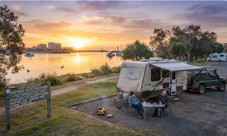
Port Macquarie Rest Area — Free Camping Guide 2026
Everything a senior grey nomad needs to know about stopping — or staying longer — at Port Macquarie on the NSW Mid North Coast. Free and low-cost options, road access, facilities, fuel gaps and honest advice for caravans and motorhomes.
Last reviewed: July 2026. Written by our travelling duo — one female, one male perspective — both authors of Australian bestselling van life guides. Confirm all fees, hours and facilities locally before arrival.
Road to town: Fully sealed. Turn off the Pacific Highway onto the Oxley Highway at Oxley Junction and drive approximately 17 km into Port Macquarie.
Flood risk on access road: Very low on the Oxley Highway itself. Some low-lying foreshore areas near the Hastings River can experience localised flooding in heavy rain — confirm locally.
Overnight options: Several council-managed foreshore areas and formal rest areas exist in and near town. Legal free overnight camping is limited — self-containment is required at most spots. Confirm current rules with Port Macquarie-Hastings Council before arrival.
Nearest hospital: Port Macquarie Base Hospital — confirm phone number locally via healthdirect.gov.au or 1800 022 222.
Dump point: Available at Port Macquarie — confirm current location and hours with council or via the Dump Point Finder app before arrival.
Best for: An overnight stop or a 2–5 night stay. This is a full-service regional city, not just a rest stop.
📑 Table of Contents
- Location, Address and GPS
- Why Grey Nomads Stop Here
- Can You Stay Overnight? Rules and Self-Containment
- Your Two Main Options Side by Side
- Facilities Table
- Road Access, Fuel Distances and Flood Risk
- Rig Size Suitability
- What Port Macquarie Doesn’t Tell You Online
- Full Facilities Comparison — Free vs Paid
- Rates — All Options Near Port Macquarie
- Senior-Friendly Things to Do
- Month-by-Month Weather and Best Time to Visit
- Wildlife and Nature
- Medical and Emergency Contacts
- Mobile Coverage by Carrier
- Fires, Generators and Overnight Etiquette
- Accessibility for Seniors
- Senior Packing Checklist
- Natural Circuit — Where to Head Next
- GPS Coordinates and Postcodes Table
- FAQ — 10 Questions Answered
- Quick Verdict
- Quick-Reference Card
- Planning Tip Box
- Disclaimer
📵 Before You Set Up Camp: Can 000 Find You Here?
Most rest areas don’t have a street address. If something goes wrong overnight, “I’m at a rest stop somewhere past the servo” wastes precious minutes. Before you unhitch, open Emergency+ and check it can pin your GPS location or generate a what3words address right where you’re parked — it works offline, so no signal doesn’t mean no location. Get it free — iPhone (App Store) or Android (Google Play).
The habit that matters: do this the moment you arrive, not if you need it. Signal drops in and out at bush camps — testing it early means you already know it works before an emergency makes that the wrong time to find out.
Bonus use: while you’re in the app, grab the GPS coordinates it shows you and save them to your own Van Life Savings Spots pin — a good stop is worth remembering for next time, and now you’ve already got the exact coordinates in hand.
1. Location, Address and GPS
Port Macquarie sits at the mouth of the Hastings River on the NSW Mid North Coast. It is approximately 385 kilometres north of Sydney, 160 kilometres south of Grafton and roughly 90 kilometres north of Bulahdelah.
The town is not directly on the Pacific Highway. You leave the Pacific Highway at Oxley Junction (also known as the Oxley Highway turnoff, near Kempsey interchange area) and travel approximately 17 kilometres east along the Oxley Highway to reach the town centre. The drive from the Pacific Highway into Port Macquarie is scenic, flat and fully sealed.
Port Macquarie’s postcode is 2444. The local government area is the Port Macquarie-Hastings Council.
📍 GPS — Port Macquarie Town Centre (Navigation Reference Point)
-31.4333, 152.9082
Nearest address reference: Short Street / Clarence Street, Port Macquarie NSW 2444 (town centre).
For specific rest areas and foreshore camping locations, use the GPS references in the table at Section 20. Confirm each location on arrival against current signage.
⚠ GPS note: Coordinates are within 50 metres of the stated location and are provided as navigation guidance only. Always confirm on arrival against current signage.
2. Why Grey Nomads Stop Here — Location Context and Overview
Port Macquarie is one of the most logical overnight stops on the entire NSW coastal run. It sits almost exactly halfway between Sydney and the Queensland border via the Pacific Highway. That arithmetic alone makes it attractive.
But this is not just a geographical convenience stop. Port Macquarie is a full-service regional city of around 50,000 people. It has a major public hospital, supermarkets, medical specialists, pharmacies, mechanical workshops experienced with caravans and motorhomes, and a wide range of accommodation from free foreshore areas to full-powered caravan parks. For grey nomads managing medications, health appointments or vehicle maintenance, that matters enormously.
The town is built around the Hastings River mouth and offers a genuine coastal feel. The foreshore is well-maintained. The CBD is flat and walkable. Beaches are accessible by vehicle. Several entry points into town accommodate larger rigs.
From the male perspective: Port Macquarie is the kind of stop where a mechanical problem stops being a crisis. There are Toyota, Hella and independent mechanical workshops in town with experience on tow vehicles and motorhomes. There are also multiple auto parts stores. If something rattles loose between Sydney and Brisbane, this is where you want it to happen.
From the female perspective: The foreshore areas near the Hastings River are genuinely pleasant for a morning walk or a seated coffee. The CBD is compact enough to navigate without a car once you’re parked. The town’s medical infrastructure — Base Hospital plus multiple GP clinics and a chemist on almost every main street block — gives real peace of mind for anyone managing a chronic health condition on the road.
Travellers heading south from Grafton or the Northern Rivers will typically arrive mid-afternoon if they leave the Northern Rivers after breakfast. Those heading north from Bulahdelah or Forster will often arrive by lunch. Either way, Port Macquarie gives you time to resupply, rest and plan the next leg.
The town already appears on most grey nomad itineraries as a transit stop. What this guide aims to do differently is tell you the specific things that don’t appear on council pages or CamperMate listings — the overnight rule nuances, the rig-specific access points, the fuel gap that catches people heading west, and the seasonal crowd patterns that most travel blogs ignore.
3. Can You Stay Overnight? Rules and Self-Containment
This is where Port Macquarie gets more complex than a simple yes or no — and where most online listings let grey nomads down badly.
The Short Answer
Legal free overnight camping within the Port Macquarie urban area is limited. The foreshore and town centre reserves are generally managed by Port Macquarie-Hastings Council and are subject to local parking and camping rules. Not all foreshore parks permit overnight sleeping in a vehicle, even if a vehicle is legally parked there.
There are designated rest areas on the approaches to town — on the Oxley Highway and on the Pacific Highway near the junction — that are managed under NSW Roads rules and permit rest stops. These are genuinely legal stopping points. However, the 24-hour rule under NSW Road Rules applies: these are rest stops, not campgrounds. Staying beyond what constitutes a rest stop can attract a fine.
Self-Containment Requirements
At any location in NSW where overnight camping is permitted for self-contained vehicles only, your rig must meet the self-containment standard. That means a fixed toilet (cassette, composting or black tank), a greywater holding tank and an independent fresh water supply. Portable camp toilets do not meet the standard at most managed locations.
NSW does not yet have a national self-containment certification scheme as universal as New Zealand’s Camping Ground Regulations. However, council-managed free camping areas that do permit self-contained vehicles will often ask you to confirm your rig meets the standard. Carry your rig’s owner documentation and any manufacturer specs that confirm toilet and grey tank capacity.
Where to Confirm Before You Arrive
Call Port Macquarie-Hastings Council directly before your trip to confirm current rules for any specific foreshore or reserve area you plan to use. Rules at these locations can change with season, local events and bylaw updates. Confirm locally — do not rely on a CamperMate or WikiCamps listing that may be 12 to 24 months out of date.
4. Your Two Main Options Side by Side — Free vs Paid
Before the facilities table, here is the honest comparison that most travel listings skip.
| Factor | Free / Low-Cost Foreshore / Rest Area Stop | Nearest Paid Caravan Park (e.g. Flynns Beach or Sundowner — confirm locally) |
|---|---|---|
| Nightly cost | Free to ~$15 (council camp fee where applicable) | Approximately $45–$90 per night powered site (confirm locally — 2026 rates) |
| Power | None at rest areas. Some council foreshore sites may have limited power — confirm locally. | 240V powered sites available at most caravan parks in town |
| CPAP users | Battery or solar required. Lithium battery users: plan for 2 nights capacity if no power available. | Powered site resolves CPAP concern completely |
| Toilets | Public toilets accessible near foreshore areas during daylight. Not always open 24 hours. | Amenities block with hot showers, flushing toilets, 24-hour access |
| Showers | Not available at rest areas. Swim at beach as substitute in warmer months. | Hot showers included in site fee |
| Dump point | Requires a separate trip to the nearest confirmed dump point — confirm location locally | Dump point on-site at most caravan parks |
| Security and lighting | Variable. Foreshore areas in town are generally well-lit. More remote rest areas are darker. | Gated or managed entry. Generally better ambient security. |
| Noise | Traffic noise at road-adjacent rest areas. Potential for late arrivals at foreshore areas. | Park rules generally enforce quiet hours. Better for light sleepers. |
| Booking required | No — turn up and park (where legally permitted) | Yes — especially in school holidays and summer. Book 2–4 weeks ahead in peak periods. |
| Stay limit | 48 hours maximum at most council areas. Rest area rules may be shorter. | Extended stays available |
| Best for | Self-sufficient rigs doing one overnight transit stop. Battery and water fully stocked. | Longer stays of 2+ nights, CPAP users, those needing showers and power daily, mobility needs. |
Our honest take: If you are in a well-equipped self-contained rig and only need one night, the free or low-cost option saves you real money. But Port Macquarie is worth more than one night for most grey nomads, and a powered site at a local park makes the longer stay far more comfortable. Don’t choose free and then spend the day uncomfortable. Choose based on your actual needs.
5. Facilities Table — Port Macquarie and Immediate Area
| Facility | Availability | Notes |
|---|---|---|
| Toilets (public) | ✅ Yes | Multiple public toilet blocks throughout town — foreshore, Town Beach, Settlement City area. Hours vary. Confirm 24-hour availability locally. |
| Drinking water (town) | ✅ Yes | Reticulated town water available at most parks and public areas. Confirm potability at each specific stop. |
| Showers (public) | ⚠ Limited | Shower facilities available at some beach areas seasonally. Confirm locally. Not available at road rest areas. |
| Dump point | ✅ Yes (confirm location) | A dump point is understood to be available within Port Macquarie. Confirm current location and operating hours with council or via the Dump Point Finder app before arrival. Do not assume the location — it may have moved since publication. |
| Power (free) | ❌ Not at rest areas | No free 240V power at road rest areas or most foreshore parks. Powered sites available at paid caravan parks only. |
| Shade | ⚠ Variable | Foreshore areas have mature trees providing shade. Road-adjacent rest areas on Oxley Highway have minimal shade. Bring a windbreak and awning. |
| BBQ facilities | ✅ Yes (foreshore parks) | Electric BBQs in several foreshore reserves. Confirm which parks have these — Town Beach foreshore area is a known example. |
| Rubbish bins | ✅ Yes (town parks) | Available in town parks and foreshore areas. Not always present at highway rest areas — carry a rubbish bag. |
| Fires / campfires | ❌ No | Open fires are not permitted at council parks or road rest areas within Port Macquarie. Use a gas cooker. |
| Generators | ⚠ Restricted | Most foreshore and town park areas restrict generator use — typically no generators after 8pm or before 8am. Confirm locally at each specific stop. |
| Pet friendly | ⚠ Conditional | Dogs on lead permitted in most foreshore areas. Not permitted on beaches at certain times. Check council signage on arrival. |
| Supermarket (nearest) | ✅ Yes — in town | Woolworths and Coles both in Port Macquarie. Aldi also present. Large carpark at Settlement City suitable for most rigs with caravan. |
| Fuel (diesel / unleaded) | ✅ Yes — multiple stations | Multiple fuel stations in Port Macquarie including on the Oxley Highway approach. See fuel section for distances north, south, east, west. |
| LPG refill | ✅ Yes | Available at major service stations and hardware stores in town. Confirm the specific station before arriving with an empty cylinder. |
| Mobile phone signal | ✅ Telstra / ⚠ Optus / ⚠ Vodafone | Telstra is the strongest carrier in this region. See mobile coverage section for detail. |
| Hospital | ✅ Yes — Port Macquarie Base Hospital | Full public hospital. Confirm current phone number via healthdirect.gov.au or 1800 022 222 before departure. |
6. Road Access, Fuel Distances and Flood Risk
Road Surface — Sealed or Unsealed?
All primary roads into Port Macquarie are fully sealed. The Pacific Highway approach from both north and south is dual-carriageway freeway standard for most of the route. The Oxley Highway from the Pacific Highway junction into town is a single-carriageway sealed road with good sight lines and a wide shoulder in most sections.
There are no unsealed sections on the standard approach to Port Macquarie from any direction for any normal caravan or motorhome configuration.
Flood Risk on Access Roads
The Oxley Highway between the Pacific Highway junction and Port Macquarie is not significantly flood-prone under normal circumstances. However, the Hastings River valley is a genuine flood zone. In major rain events — particularly La Niña periods — the Hastings River can rise quickly.
Low-lying areas of Port Macquarie near the river have experienced flooding in previous major events. The highway approaches generally remain open during moderate rainfall. In an extreme event, check Live Traffic NSW (livetraffic.com) before departing for any leg involving the Oxley Highway or river-adjacent roads in the area.
Fuel Distances — North, South, East and West
| Direction | Next Town / Fuel Stop | Approximate Distance | Road | Notes |
|---|---|---|---|---|
| North (Pacific Hwy) | Kempsey | ~45 km | Pacific Highway (A1) — fully sealed | Multiple fuel stations in Kempsey. No fuel gap concern on this leg. |
| North (Pacific Hwy, continuing) | Macksville / Nambucca Heads | ~80 km from Port Macquarie | Pacific Highway — fully sealed | Fuel available. Good stop for a break. |
| South (Pacific Hwy) | Taree / Wingham area | ~80 km | Pacific Highway — fully sealed | Fuel in Taree. No gap concern heading south. |
| South (continuing) | Bulahdelah / Forster turnoff | ~90 km from Port Macquarie | Pacific Highway — fully sealed | Fuel available at Bulahdelah. See our Bulahdelah to Forster free camping guide. |
| East | Port Macquarie town centre / beaches | 0 km — you are already here | Oxley Highway into town — fully sealed | Fuel stations on Oxley Highway and within town. |
| West (Oxley Highway inland) | Wauchope | ~19 km west of Port Macquarie | Oxley Highway — fully sealed | Fuel available at Wauchope. Good for LP gas refills too. |
| West (continuing inland) | Walcha | ~130 km west of Port Macquarie via Oxley Highway | Oxley Highway — sealed but mountain road with tight bends through the Oxley Wild Rivers section | ⚠ Critical fuel gap alert: If you are heading west on the Oxley Highway toward Walcha and the New England Tablelands, fill your tank in Port Macquarie or at Wauchope before departure. The Oxley Highway through the ranges — particularly through Werrikimbe National Park country — has no fuel availability for approximately 100+ km. This is a known trip-ender for unprepared travellers. This section is also not suitable for wide rigs above approximately 2.5m wide or for rigs over about 8m total length in some of the tighter mountain sections — confirm your specific rig suitability before attempting this route. |
7. Rig Size Suitability
Port Macquarie itself accommodates large rigs well, with some specific exceptions.
General Town Access
The Oxley Highway approach into Port Macquarie is wide, well-surfaced and suitable for any standard caravan or motorhome configuration. Road trains do not operate on this section. Traffic is manageable outside of peak hour periods (7–9am and 4–6pm on weekdays).
Town Centre Navigation
The Port Macquarie CBD has some narrow side streets. Avoid towing a van through the main shopping precinct unless you know the specific route to your intended carpark. The Settlement City shopping centre on the southern approach to town has an expansive carpark suitable for long rigs and van combinations. This is the recommended resupply stop for anyone with a rig over 8 metres total length.
Foreshore Areas
Some foreshore reserve car parks have low-hanging trees or tight turning circles. A Class A motorhome above 8 metres, or a van combination above 10 metres total, should recce any specific foreshore area on foot before committing to an overnight park. Town Beach foreshore area is one example where tree canopy can be an issue for tall rigs — confirm locally before arrival.
Westbound on the Oxley Highway
As noted in the fuel section, the Oxley Highway west of Wauchope through the mountain range is not suitable for all rig sizes. Wide rigs above approximately 2.5 metres and long combinations above 8 metres total should not attempt this route without first checking current road conditions and bend radii. This is not a casual decision. Confirm with NSW Roads before departure if you plan this leg.
8. What Port Macquarie Doesn’t Tell You Online
This section covers what CamperMate, WikiCamps, council tourism pages and generic travel blogs consistently leave out. These are the things that genuinely matter when you arrive with a rig.
1. The Oxley Highway Westbound Fuel Gap Is Underreported and Genuinely Dangerous
Every major travel site covers Port Macquarie as a coastal stop. Almost none of them address the fuel situation if you plan to head west on the Oxley Highway after your stop. The gap from Wauchope to the next fuel availability heading toward Walcha exceeds 100 kilometres on a mountain road with no phone signal in sections. This is not a minor oversight — it is a trip-ending situation for travellers who don’t plan for it. Fill up in Port Macquarie. Fill up again in Wauchope. Do not leave this to chance.
2. The Hastings River Foreshore Is Louder Than It Looks in Photos
Foreshore park photos on tourism sites are taken in the early morning when the river precinct is quiet. By afternoon on weekends, the foreshore near the CBD becomes a popular social space with music, families and activity. The evening generally quietens down, but if you are a light sleeper, the proximity to the town centre means ambient noise levels are higher than at a true bush camp. From a female traveller’s perspective, the level of foot traffic through these areas also means personal privacy — particularly for morning routines near the van — is lower than at more isolated stops. Have your camp set up facing away from main pedestrian paths if possible.
3. Peak Season at Port Macquarie Is Earlier Than Most People Expect
The school holiday Christmas and Easter peaks are obvious. What most guides miss is that Port Macquarie also becomes very busy during the October long weekend (Labour Day NSW) and during the May school holidays — because the Mid North Coast’s mild autumn weather makes it attractive to families escaping colder southern cities. Grey nomads often plan around the obvious summer peak but get caught by the autumn surge. If you’re travelling in May, treat it the same as school holidays and book your paid site well in advance.
4. The Dump Point Location Is Not Consistently Signposted from the Main Road
Multiple travellers have reported that finding the dump point in Port Macquarie requires prior knowledge or the Dump Point Finder app — standard roadside signage is not always visible approaching from the Pacific Highway direction. Get the GPS coordinates for the dump point from the app before you arrive, not when you are already driving through town with a full cassette. Confirm the current location with the council as it has reportedly been relocated in recent years.
5. The Settlement City Carpark Is the Rig-Friendly Resupply Option Most Guides Don’t Mention
Tourism sites send travellers to the CBD for shopping. For anyone with a caravan, the Settlement City complex on the southern end of town is far more practical. The carpark is large, flat and has good clearance. Both Woolworths and Coles are accessible without unhitching. This is common knowledge among regular travellers on this route, but it is essentially absent from every published grey nomad guide we could find about Port Macquarie.
6. Medical Specialist Appointments Are a Real Use Case Here
Port Macquarie Base Hospital and the surrounding specialist medical precinct means this town functions as a referral centre for the entire Mid North Coast. Grey nomads travelling this route often plan a stop specifically around a specialist appointment, cardiology review, or optical/audiology visit. The town’s medical infrastructure is genuinely comprehensive by regional standards. If you have a pending specialist appointment, Port Macquarie is one of the few regional towns on this coast where you might actually get seen without travelling to Sydney or Brisbane. Confirm with your GP about any referral options before departing.
9. Full Facilities Comparison — Free Option vs Paid Caravan Park
| Facility | Free / Rest Area Stop | Paid Caravan Park (Port Macquarie) |
|---|---|---|
| Power (240V) | ❌ None | ✅ Available on powered sites |
| Hot showers | ❌ Not at rest areas | ✅ Included in site fee |
| Flushing toilets (24hr) | ⚠ Public blocks nearby — hours vary | ✅ On-site amenities block |
| Dump point on-site | ❌ Separate trip required | ✅ On-site at most parks |
| Drinking water on tap | ⚠ May be available at foreshore parks — confirm | ✅ On-site |
| Laundry | ❌ Not available | ✅ Coin-operated laundry at most parks |
| Wi-Fi | ❌ Not available | ⚠ Some parks offer limited park Wi-Fi — speeds vary |
| Pet friendly | ✅ On-lead in most foreshore areas | ⚠ Some parks allow pets — confirm when booking |
| Shade / shelter | ⚠ Variable — foreshore has trees, highway stops minimal | ⚠ Variable — depends on site allocation |
| Security / management | ⚠ Unmanaged — public areas | ✅ Manager on site, often gated |
| Stay limit | Up to 48 hours (or shorter at rest areas) | Extended stays available |
| Nightly cost | Free to ~$15 (council fee where applicable) | ~$45–$90 powered site (confirm locally — 2026 rates) |
| Booking required | No | Yes — especially peak periods |
10. Rates — All Options Near Port Macquarie
Rates at caravan parks change regularly. The figures below are indicative for 2026. Always confirm directly with the park before booking. Do not rely on rates printed in any guide — including this one — for budget planning without a direct check.
| Option | Indicative Nightly Rate (2026) | Notes |
|---|---|---|
| Free foreshore / rest area stop (self-contained) | Free | Where legally permitted. Confirm with council. No facilities at road rest areas. |
| Council-managed low-cost foreshore area (where applicable) | ~$10–$20 per night | Confirm current fee structure with Port Macquarie-Hastings Council. Some areas may have changed to paid status since publication. |
| Powered site — mid-range caravan park in Port Macquarie | ~$45–$70 per night | Confirm locally. Rates increase significantly in Christmas/Easter/school holiday periods. |
| Powered site — beachside or premium park | ~$70–$90+ per night | Premium parks on or near the beach command higher rates. Book early for peak periods. |
| Unpowered site — caravan park | ~$30–$50 per night | Still cheaper than powered. Useful if you have good solar and don’t need mains power daily. |
11. Senior-Friendly Things to Do in Port Macquarie
Port Macquarie punches above its weight for a regional coastal town. The following are genuinely senior-friendly — flat, accessible, seated-experience options or gentle activity. This is not a list copied from a tourism brochure. It is filtered specifically for the over-60 traveller.
Flat Coastal Walks
The Coastal Walk from Town Beach south toward Lighthouse Beach is one of the best coastal paths on the NSW Mid North Coast. Sections of it are paved and wheelchair-accessible. The full walk is approximately 9 kilometres, but you can walk any section and return. The section between Town Beach and Nobby’s Beach is the most accessible — flat, paved and with public toilets and seating at regular intervals.
The Hastings River foreshore walk near the town centre is entirely flat, paved and accessible for mobility aids. This walk is suitable for walkers with knee or hip concerns. Distance is flexible — turn around whenever you choose.
Sea Acres Rainforest Centre
Sea Acres National Park features a 1.3-kilometre elevated boardwalk through coastal rainforest. The boardwalk is flat, entirely on raised timber, and accessible for wheelchairs and walkers. This is one of the most senior-friendly nature experiences on the entire NSW coast. Entry fees apply — confirm current pricing with NPWS before visiting (npws.nsw.gov.au).
Port Macquarie Koala Hospital
The Koala Hospital at Lake Innes Nature Reserve is Australia’s first and oldest koala hospital. Entry is by donation. Koala feeding and care demonstrations occur at 3pm daily — confirm current times locally. The grounds are flat and accessible. This is a genuine, non-kitsch wildlife experience. Many grey nomads list this as one of the highlights of the entire coastal run. The hospital cares for injured and sick koalas and returns them to the wild — it is a working rehabilitation facility, not a tourist park.
Town Beach and Lighthouse Beach
Both beaches have accessible parking, flat approaches and public facilities. Swimming is good for reasonably able-bodied seniors — both beaches are patrolled seasonally by surf lifesavers. Check patrol flags and times before entering the water. Current information is available from Surf Life Saving NSW (surflifesaving.com.au).
Roto House and Historical Museum
Roto House is a heritage-listed Victorian residence. The Port Macquarie Historical Society Museum is nearby. Both offer seated, air-conditioned experiences relevant to the town’s history. Entry fees apply — confirm locally. Good for a rainy day stop.
Tacking Point Lighthouse
Tacking Point Lighthouse is the oldest lighthouse on the NSW Mid North Coast. The area around it offers excellent whale-watching from the shore during the annual migration (June to November). The path to the lighthouse lookout involves some uneven ground but is short. For those with limited mobility, the view from the carpark area is still impressive. Sunrise here is genuinely worth the early wake-up.
Suggested Day Plan — Senior Grey Nomad in Port Macquarie
Morning (7:30am): Walk the Hastings River foreshore from the town centre — flat, paved, 30 to 45 minutes at a comfortable pace. Return for breakfast at the van or at one of the foreshore cafés.
Mid-morning (10:00am): Drive or walk to Sea Acres boardwalk. Allow 60 to 90 minutes. Flat and fully accessible.
Midday: Return to town. Resupply at Settlement City if needed. LPG check if due.
Afternoon (2:00pm): Drive to Tacking Point Lighthouse for whale-watch (seasonal). Return via Town Beach for a swim or a sit with a coffee.
Late afternoon (3:00pm): Koala Hospital feeding demonstration. End the day here.
12. Month-by-Month Weather and Best Time to Visit
Port Macquarie has one of the mildest coastal climates in NSW. It is genuinely temperate year-round, which is exactly why so many grey nomads treat it as a base for extended stays rather than just a transit stop. Use this table to plan your visit around your specific comfort requirements.
| Month | Avg Max Temp | Avg Min Temp | Avg Rainfall | Crowd Level | Grey Nomad Verdict |
|---|---|---|---|---|---|
| January | ~28°C | ~19°C | ~130mm | 🔴 Very High | Peak summer. School holidays. Caravan parks full. Foreshore busy. Avoid if possible. |
| February | ~28°C | ~19°C | ~140mm | 🔴 High | Still hot and humid. Late-season cyclone risk on the coast. Not ideal for open camping. |
| March | ~27°C | ~17°C | ~130mm | 🟡 Medium | Crowds easing. Still warm. Pleasant for walking. Rain possible. Good shoulder option. |
| April | ~24°C | ~14°C | ~110mm | 🟡 Medium–High (Easter) | Easter week is very busy. Outside Easter, April is excellent — warm, low humidity, calm seas. |
| May | ~22°C | ~11°C | ~90mm | 🟡 Medium | School holidays in NSW bring families. Otherwise a very good month. Mild, pleasant, less crowded. |
| June | ~19°C | ~9°C | ~90mm | 🟢 Low | Excellent. Cool but comfortable. Grey nomad season peaks. Whale migration begins. Great visibility for whale-watching. |
| July | ~18°C | ~8°C | ~80mm | 🟢 Low–Medium | Our recommended month. Cool nights (have your heater ready), calm days, minimal crowds, excellent whale migration viewing. Light rain possible — have your awning sealed. |
| August | ~19°C | ~8°C | ~70mm | 🟢 Low | Driest month on average. Clear skies. Excellent coastal walking conditions. Whales still active. Best overall month for many grey nomads. |
| September | ~22°C | ~11°C | ~70mm | 🟡 Medium | Warming up. School holidays in some states. Spring flowers in hinterland. Still good value on accommodation. |
| October | ~24°C | ~14°C | ~90mm | 🟡 Medium–High (Labour Day) | Long weekend brings crowds. Outside the long weekend, October is very pleasant. Start of warmer swimming weather. |
| November | ~26°C | ~16°C | ~100mm | 🟡 Medium | Pre-summer warmth. Good swimming. Crowds building toward December. Book early if planning a longer stay. |
| December | ~28°C | ~18°C | ~120mm | 🔴 Very High | Christmas peak. Caravan parks and free areas at maximum capacity. Prices highest. Avoid unless already booked well in advance. |
13. Wildlife and Nature at Port Macquarie
Humpback Whale Migration
The annual humpback whale migration passes close to the Port Macquarie coastline between June and November. June to September is the peak southbound migration period. September to November covers the return northward migration. Tacking Point Lighthouse and the elevated sections of the Coastal Walk offer excellent shore-based viewing. Binoculars are worthwhile. Whales are often visible without them in good conditions.
Koalas
Koalas are genuinely present in the area. Lake Innes Nature Reserve — where the Koala Hospital is based — is a known koala habitat. Drive carefully near bushland roads at dawn and dusk. Koalas on roads are a real risk, particularly on roads through reserve areas. They move slowly and are difficult to see in low light. If you see one on the road, do not try to move it yourself — call the Koala Hospital on the number displayed at their facility (confirm locally) or WIRES on 1300 094 737 (confirm locally — verify via wires.org.au before relying on this number).
Shorebirds and Waterbirds
The Hastings River estuary and the wetlands around the river mouth support a diverse range of shorebirds. Pelicans are common and highly visible from the foreshore. The tidal flats attract waders — oystercatchers, sandpipers and plovers. A pair of binoculars adds genuine value to time spent on the foreshore.
Dolphins
Indo-Pacific bottlenose dolphins are regularly seen in the Hastings River mouth and in the surf breaks near the beaches. You don’t need a boat to see them — they come close to shore. The river mouth near the breakwall is a reliable viewing spot in the early morning.
Mosquitoes
Near the river and the wetlands, mosquitoes can be active, particularly at dawn and dusk and after rain. This is more relevant to those sleeping in unsealed or mesh-door setups. Apply repellent, ensure your van’s fly screens are intact, and consider the Hastings River foreshore a moderate mossie zone. The exposed beach areas are much less affected due to coastal breeze.
14. Medical and Emergency Contacts
| Service | Name / Location | Phone | Notes |
|---|---|---|---|
| Emergency | All emergencies | 000 | Police, ambulance, fire. Works on any carrier with any signal, including no credit. |
| Public Hospital | Port Macquarie Base Hospital, Wright Road, Port Macquarie NSW 2444 | Confirm locally via healthdirect.gov.au or call 1800 022 222 | Full public hospital. 24-hour emergency department. Confirm phone number from at least 3 independent sources before relying on any number printed here. |
| Health Direct (After Hours GP Advice) | National — telephone | 1800 022 222 | 24-hour nurse and GP advice line. Free call. Excellent for after-hours questions that don’t require an emergency department visit. |
| WIRES Wildlife Rescue | National | 1300 094 737 — confirm via wires.org.au | For injured wildlife including koalas. Do not attempt to handle injured wildlife yourself. |
| Koala Hospital Port Macquarie | Lake Innes Nature Reserve | Confirm locally on arrival — displayed at facility entrance | For injured koalas specifically. First port of call before WIRES in this region. |
| Port Macquarie-Hastings Council | 17 Burrawan Street, Port Macquarie | (02) 6581 8111 — confirm locally via pmhc.nsw.gov.au | For camping rules, dump point location, foreshore area queries. |
| NSW SES (Storm / Flood) | NSW State Emergency Service | 132 500 | For storm and flood emergencies. Relevant in heavy rain events given Hastings River flood potential. |
| Live Traffic NSW | Road condition and closure information | 132 701 or livetraffic.com | Check before any leg involving the Oxley Highway ranges or Pacific Highway after heavy rain. |
15. Mobile Coverage by Carrier
Mobile coverage in Port Macquarie is generally good across all three major carriers within the town. The situation changes significantly as soon as you leave town — particularly heading west.
| Carrier | Port Macquarie Town | Oxley Highway East (Wauchope direction) | Oxley Highway West (ranges, toward Walcha) | Pacific Hwy (North toward Kempsey) | Pacific Hwy (South toward Taree) |
|---|---|---|---|---|---|
| Telstra | ✅ Excellent | ✅ Good to Wauchope | ⚠ Patchy — drops out in gorge sections. No coverage for extended sections. | ✅ Good | ✅ Good |
| Optus | ✅ Good in town | ⚠ Patchy west of town | ❌ Limited to no coverage in ranges | ⚠ Variable | ⚠ Variable |
| Vodafone / TPG | ✅ Good in town | ⚠ Limited west of town | ❌ Minimal coverage in ranges | ⚠ Variable | ⚠ Variable |
Practical advice: If you are on Optus or Vodafone, do all your phone-dependent tasks — downloading maps offline, syncing medications reminders, checking bank accounts — while in Port Macquarie town. Do not assume coverage will continue on the Oxley Highway ranges or on some sections of the Pacific Highway through national park areas. Telstra users are in a much stronger position throughout this region.
If you regularly travel remote routes, a Telstra SIM in a backup device (a basic handset or a dedicated router with a Telstra SIM) is a genuine safety investment — not just a convenience.
16. Fires, Generators and Overnight Etiquette
Open Fires
Open fires are not permitted at council-managed parks, foreshore reserves or road rest areas within or immediately adjacent to Port Macquarie. This applies year-round, not just during declared fire danger periods. Use a gas cooker or a portable butane stove. If you need a campfire experience, you need to be in a designated national park or state forest area well outside town — and even then, check for fire bans before lighting anything.
Generators
Most council and foreshore areas in Port Macquarie restrict generator use. The common rule is no generators before 8am or after 8pm. Some areas have stricter limits. If you rely on a generator for CPAP or battery charging, plan to do your charging during the permitted daytime window. At a powered caravan park site, this issue disappears entirely. This is a real consideration when choosing free versus paid for CPAP users.
Noise and Respect
Foreshore areas near the town centre attract people of all kinds. You are sharing a public space. Reasonable quiet hours from 10pm are both courteous and practical. If you have a rig with a diesel heater that is noisy at startup, position the exhaust away from neighbouring rigs and be mindful of early-morning startup if others are still sleeping.
Rubbish
Pack it in, pack it out at road rest areas where bins are absent. At foreshore and town parks, use the provided bins. Do not leave rubbish bags beside full bins — this attracts birds and creates a council problem that eventually leads to restrictions or closures at these areas. Grey nomads who do the right thing protect access for everyone who comes after them.
17. Accessibility for Seniors and Mobility Considerations
Port Macquarie is one of the more accessible coastal towns in NSW for travellers with mobility limitations. This is a genuine assessment, not tourism-brochure language.
What Is Genuinely Accessible
- The Hastings River foreshore path is paved and flat — suitable for wheelchairs, walkers and mobility scooters.
- Sea Acres boardwalk is wheelchair accessible throughout its 1.3-kilometre length.
- Town Beach and Settlement City carparks have designated accessible parking bays.
- The Koala Hospital grounds are flat and accessible for most mobility aids.
- Port Macquarie Base Hospital has full disability-accessible facilities.
- Most CBD shops and cafés on the main streets have flat or ramped entries.
What Is Harder for Mobility-Limited Travellers
- Tacking Point Lighthouse has some uneven ground on the final approach — manageable for most but not ideal for walkers or wheelchairs.
- Some foreshore carpark surfaces near the river are on loose gravel — check the specific area before committing a wheelchair or walker to that surface.
- The Coastal Walk has some sections that are uneven compacted gravel — fine for confident walkers but check before using a wheelchair.
- The Oxley Highway rest areas on the highway approach have no accessibility infrastructure — basic stops only.
CPAP and Medical Equipment
For grey nomads on CPAP, the choice between a free (unpowered) stop and a powered caravan park site is genuinely medical, not just a comfort preference. If your battery bank cannot sustain two or three nights of CPAP use, budget for a powered site. Your sleep quality and respiratory health are not places to save a few dollars. The powered site option in Port Macquarie is the right call if there is any doubt about your battery capacity.
18. Senior Packing Checklist — Port Macquarie Specific
This checklist is for Port Macquarie specifically. Expand each item to understand why it matters at this location — not just in general.
☐ Binoculars
Port Macquarie is on the humpback whale migration route and has resident dolphins in the estuary. A decent pair of binoculars transforms both the Tacking Point headland experience and the Hastings River foreshore from pleasant to genuinely memorable. 8×42 is the recommended specification for coastal viewing — stable enough for use on a gentle sea breeze day.
☐ Battery Bank / Lithium Power Station (CPAP users)
If you plan a free unpowered stop in Port Macquarie, generators are restricted after 8pm. Your battery bank needs to sustain CPAP overnight without generator top-up. A lithium power station of at least 500Wh is the minimum for most CPAP machines running one night. For two nights without power, double that capacity or add a solar panel to the equation.
☐ Dump Point Finder App (pre-loaded)
The dump point in Port Macquarie is not consistently signposted from the main road. Load the Dump Point Finder app and save the GPS coordinates of the Port Macquarie dump point before you arrive — not when you’re already driving around town with a full cassette and no idea where to go.
☐ Mosquito Repellent and Fly Screens (intact)
The Hastings River foreshore and the wetland areas around Port Macquarie can have significant mosquito activity at dawn and dusk, particularly after rain. Check your van’s fly screens are fully intact before parking near the river. Carry DEET-based or picaridin-based repellent. This is a subtropical coastal zone — don’t underestimate the mossies.
☐ Weather-appropriate layers for cool nights
In winter (June–August), Port Macquarie nights drop to 8–10°C. The days are mild and pleasant but the evenings cool quickly once the sun drops. A light fleece, a heated blanket or a diesel air heater set to come on before dawn are worthwhile for winter visitors. This is especially relevant for those with Raynaud’s syndrome, arthritis or poor circulation.
☐ Full fuel tank before heading west on Oxley Highway
If your trip plan takes you west on the Oxley Highway toward Walcha and the New England Tablelands, fill up in Port Macquarie and top up at Wauchope. There is no fuel for well over 100 kilometres on the mountain section. This is not an exaggeration — it has caught out multiple travellers. A full tank in Port Macquarie is not optional if you are heading west.
☐ Offline maps downloaded (especially for westbound travel)
Mobile signal drops significantly on the Oxley Highway through the ranges west of Wauchope. Download the offline map for this section before you leave Port Macquarie while you still have 4G. Google Maps and Maps.me both support offline download. This is a basic but often forgotten step.
☐ Emergency+ app set up and tested at your parking spot
Open the Emergency+ app the moment you park at any rest area or foreshore spot in Port Macquarie and confirm it can generate a GPS coordinate or what3words address for that exact location. If you ever need an ambulance in the night, “I’m parked at the Port Macquarie foreshore somewhere” is not enough. The app works offline — test it while you have signal so you know it’s working before you need it.
☐ Gas cooker (open fires not permitted)
Open fires are prohibited at all council-managed areas and road rest areas in and around Port Macquarie. A portable gas or butane cooker is the only viable cooking method at these stops. If your LPG is running low, multiple refill options are available in town — but check stock at your chosen station before arrival rather than assuming.
☐ Seniors Card / Pension Card
Several attractions in Port Macquarie offer concession rates on production of a Seniors Card or pension concession card. Sea Acres NPWS entry, the Koala Hospital donation (suggested amounts), and caravan park senior discounts are all worth asking about specifically. These discounts are rarely advertised — you need to ask.
☐ Printed medication list and GP summary
Port Macquarie Base Hospital is a major regional facility. If you need emergency treatment, having a printed medication list and a current GP summary speeds your care significantly. Keep one copy in the glove box and one with a person who travels with you. This is relevant at every stop but Port Macquarie’s hospital is capable of managing complex presentations — give them the information they need to help you quickly.
19. Natural Circuit — Where to Head Next
Port Macquarie sits almost exactly in the middle of the NSW coastal run. Here is how it connects to nearby destinations already covered on this site.
🗺 Heading north toward Queensland? The Northern Rivers region — from Grafton through to Yamba, Ballina and the hinterland — has a range of free and low-cost options covered in our Northern Rivers Rest Areas guide.
🗺 Planning your NSW route more broadly? Our Rest Areas NSW overview covers the full state network so you can plan each leg in advance rather than discovering options only when you arrive.
💰 Looking to reduce costs overall? Port Macquarie is a useful place to reassess your spending for the next leg. Our Van Life Savings Spots guide covers strategies to reduce overnight costs without sacrificing comfort or safety.
20. GPS Coordinates and Postcodes — Port Macquarie Reference Table
| Location | GPS Coordinates | Postcode | Notes |
|---|---|---|---|
| Port Macquarie Town Centre (navigation reference) | -31.4333, 152.9082 | 2444 | Town centre reference point only. Not a specific camping location. |
| Port Macquarie Base Hospital | -31.4267, 152.8975 (confirm locally — hospital coordinates) | 2444 | ⚠ Confirm these coordinates match current hospital signage on arrival. Wright Road, Port Macquarie. |
| Hastings River Foreshore (general reference) | -31.4322, 152.9110 | 2444 | General reference for the foreshore area near the town centre. Confirm specific parking and overnight rules with council before use. |
| Sea Acres Rainforest Centre (boardwalk) | -31.4589, 152.9228 (confirm locally) | 2444 | Accessible boardwalk. Entry fees apply. ⚠ Confirm GPS on arrival against NPWS signage. |
| Tacking Point Lighthouse | -31.4847, 152.9369 (confirm locally) | 2444 | Whale-watching viewpoint. Short unsealed path to lighthouse structure — suitable for most walkers. ⚠ Confirm GPS on arrival. |
| Koala Hospital (Lake Innes Nature Reserve) | -31.4617, 152.8867 (confirm locally) | 2444 | Feeding demonstration 3pm daily (confirm current times). Entry by donation. ⚠ Confirm GPS on arrival against hospital signage. |
| Settlement City (rig-friendly resupply carpark) | -31.4476, 152.8953 (confirm locally) | 2444 | Large flat carpark. Woolworths and Coles accessible. Recommended for rigs over 8 metres. ⚠ Confirm GPS on arrival. |
| Dump Point (confirm current location) | Confirm via Dump Point Finder app before arrival | 2444 | Location has reportedly changed in recent years. Do not rely on any printed GPS for the dump point — verify via app or council directly. |
⚠ GPS note: Coordinates are within 50 metres of the stated location and are provided as navigation guidance only. Always confirm on arrival against current signage.
21. FAQ — 10 Questions Answered
Q1: Is there free camping at Port Macquarie?
Free overnight camping within Port Macquarie’s urban area is limited and subject to council rules that can change. Some foreshore areas permit self-contained overnight stays at no or low cost — but you must confirm this with Port Macquarie-Hastings Council before arrival. The Pacific Highway rest areas on the approaches to town permit rest stops under NSW Road Rules, but are not campgrounds and are not designed for extended overnight stays. Do not rely on any single app or website listing as confirmation that a specific spot is legal — call the council or check pmhc.nsw.gov.au directly.
Q2: Where is the dump point in Port Macquarie?
A dump point is understood to be available within Port Macquarie. However, its exact location and hours are subject to change, and signage from the main road is not always clear. The best approach is to check the Dump Point Finder app and load the GPS coordinates before you arrive, or call Port Macquarie-Hastings Council on (02) 6581 8111 (confirm this number via pmhc.nsw.gov.au) before your visit. Do not assume the location has not moved since any published guide — including this one — was written.
Q3: Is Port Macquarie suitable for large rigs and caravans?
Yes, for standard caravan and motorhome combinations up to approximately 10–12 metres total length on the main approaches and in the town’s larger carparks (particularly Settlement City). Some foreshore carparks have tight turning circles or low-canopy trees. The Oxley Highway westbound through the ranges is not suitable for wide rigs above approximately 2.5 metres or for combinations above approximately 8 metres total — confirm with NSW Roads before attempting that leg.
Q4: What is the nearest hospital to Port Macquarie?
Port Macquarie Base Hospital is the nearest and most capable medical facility. It is a full public hospital with a 24-hour emergency department, located on Wright Road, Port Macquarie NSW 2444. Confirm the current phone number via healthdirect.gov.au or by calling 1800 022 222 before your trip — do not rely on any single printed source including this guide.
Q5: Does the Pacific Highway flood near Port Macquarie?
The Pacific Highway itself has been significantly upgraded in recent years and flood-prone sections have largely been rerouted onto higher ground. The highway is generally open during normal rain events. However, in major rainfall — particularly events involving the Hastings River catchment on the New England Tablelands — localised flooding can affect approaches to Port Macquarie. Check Live Traffic NSW at livetraffic.com or call 132 701 before departing for any leg after significant rain. The Oxley Highway between the Pacific Highway and Port Macquarie town is generally not flood-prone on the road surface itself, but the river valley adjacent to the road can be inundated in extreme events.
Q6: What mobile carrier works best in Port Macquarie?
Telstra is the strongest carrier in Port Macquarie and on the surrounding highways. Within the town itself, Optus and Vodafone/TPG also provide reasonable coverage. As soon as you travel west on the Oxley Highway beyond Wauchope and into the mountain ranges, Telstra is the only carrier with any meaningful coverage — and even Telstra has gaps in the gorge sections. If you are on Optus or Vodafone, complete all signal-dependent tasks while in town before heading west.
Q7: Can I use my CPAP machine at a free camping spot in Port Macquarie?
At a free or unpowered stop, yes — but only if your battery bank or solar setup can sustain CPAP power through the night. Generator use is typically restricted to daytime hours at most council-managed areas. For CPAP users who do not have an adequate independent power solution, the strongly recommended option is a powered site at a caravan park in Port Macquarie. The cost difference between free and a $50–$60 powered site is not worth compromising your respiratory health and sleep quality over.
Q8: Is there fuel at Port Macquarie and what about heading west?
Multiple fuel stations operate in Port Macquarie, including on the Oxley Highway approach. Heading north or south on the Pacific Highway, fuel is available at regular intervals — Kempsey is approximately 45 km north and Taree is approximately 80 km south. Heading west on the Oxley Highway, fuel is available at Wauchope (approximately 19 km west of Port Macquarie). Beyond Wauchope toward Walcha and the New England Tablelands, there is no fuel for well over 100 kilometres on a mountain road through national park terrain with limited phone signal. Fill up in Port Macquarie and top up at Wauchope without exception if you are heading west.
Q9: When is the best time of year to visit Port Macquarie as a grey nomad?
June, July and August are the optimal months for grey nomads. Crowds are at their lowest. Caravan park rates are at their most affordable. The weather is mild and walkable with cool but comfortable nights. The humpback whale migration is active and visible from shore. Rainfall is at its lowest annual average. The worst times are December and January (peak summer and school holidays) and Easter week — these periods see maximum crowds, maximum prices and minimum availability at both free and paid sites.
Q10: How long should grey nomads plan to stay at Port Macquarie?
Unlike a pure highway rest stop, Port Macquarie warrants at least two to three nights for most grey nomads. The Coastal Walk, Sea Acres boardwalk, Koala Hospital, Tacking Point Lighthouse and Hastings River foreshore together make a full two-day itinerary without rushing. If you add in resupply, medical appointments, vehicle maintenance or simply a rest day, three to five nights is entirely reasonable. Grey nomads who stop for one night and move on consistently report wishing they had stayed longer.
22. Quick Verdict
Port Macquarie is not just a rest area — it is one of the best all-round stops on the entire NSW coastal route for grey nomads. Its strengths are consistent and real: a major hospital, full retail and medical services, genuinely accessible nature experiences, a mild coastal climate, and a town that has been accommodating to travellers for generations.
The free and low-cost options require more research and confirmation than a simple app listing suggests. Rules change. The dump point moves. Foreshore overnight rules have conditions. Do the homework before you arrive — one phone call to council saves a night of confusion.
The single most important piece of advice in this entire guide: if you are heading west on the Oxley Highway after Port Macquarie, fill your fuel tank here and again at Wauchope. Everything else at this location is manageable. That fuel gap is not.
For June through August, Port Macquarie gets our strongest recommendation on the NSW coast. Mild, accessible, full-service, whale season, and genuinely underrated by grey nomads who rush through it.
23. Quick-Reference Card — Screenshot and Save
| Item | Detail |
|---|---|
| Location | Port Macquarie, NSW Mid North Coast. Postcode 2444. ~385 km north of Sydney, ~160 km south of Grafton. |
| Road access | Fully sealed. Pacific Highway to Oxley Highway turnoff — 17 km east into town. |
| Flood risk | Low on road. Hastings River foreshore can flood in extreme events. Check Live Traffic NSW after heavy rain. |
| Free camping | Limited and conditional. Confirm with Port Macquarie-Hastings Council before arrival — (02) 6581 8111 (confirm via pmhc.nsw.gov.au). |
| Powered sites | ~$45–$90/night. Book early for school holidays and peak periods. |
| Dump point | Available in Port Macquarie — confirm current location via Dump Point Finder app before arrival. |
| Nearest hospital | Port Macquarie Base Hospital, Wright Road — confirm phone via healthdirect.gov.au / 1800 022 222. |
| Fuel north | Kempsey ~45 km. No gap concern. |
| Fuel south | Taree ~80 km. No gap concern. |
| Fuel west ⚠ | Wauchope ~19 km. After Wauchope: NO FUEL for 100+ km. Fill in Port Macquarie and at Wauchope. |
| Best mobile carrier | Telstra. Essential if heading west on Oxley Highway. |
| Open fires | Not permitted at any council or rest area in or near Port Macquarie. |
| Generators | Restricted — typically 8am–8pm at council areas. Confirm locally. |
| Best months | June, July, August. Avoid December, January and Easter week. |
| Recommended stay | 2–5 nights for a full experience. One night minimum as a coastal transit stop. |
| Top senior experience | Sea Acres boardwalk (accessible), Koala Hospital, Tacking Point whale watching (June–November), Hastings River foreshore walk. |
24. Planning Tip Box — Before You Leave
Heading south after Port Macquarie? Plan your next free camp with our Bulahdelah to Forster free camping guide.
Heading north toward the Queensland border? Our Northern Rivers Rest Areas guide covers the Grafton, Yamba and Ballina corridor in detail.
Planning across multiple NSW legs? Use our Rest Areas NSW hub to map the full coastal and inland route before you depart.
Want to track your best free stops for the return trip? Add Port Macquarie to your Van Life Savings Spots — grab the GPS from Emergency+ when you arrive and save it for the next time you pass through.
COPY PROMPT ➔ ASK AI ➔ SAVE TO FORM ➔ ADD SPOT PIN ➔ GET DIRECTIONS
📍 Interactive map — find free camps, rest areas and overnight stops. Enable location for best results.

As an affiliate, I earn from qualifying purchases at no extra cost to you.

As an affiliate, I earn from qualifying purchases at no extra cost to you.