Olympic Highway and Hume Highway Free Camping — Complete Rest Area Guide for Grey Nomads 2026
Every free rest area and overnight stop between Wagga Wagga and Albury on the Olympic Highway, and along the connecting Hume Highway corridor — researched, mapped and honestly assessed for senior grey nomads aged 60 and over travelling in caravans, motorhomes and campervans in 2026.
📅 Last reviewed: April 2026 | NSW — Olympic Highway and Hume Highway corridor | All stops subject to change — always verify signage on arrival
The Olympic Highway between Wagga Wagga and Albury, and its connecting Hume Highway corridor through Gundagai, Tarcutta and Holbrook, make up one of the most-travelled grey nomad routes in inland New South Wales. This guide brings together every free rest area and overnight stop along these two corridors into a single, honest resource for senior grey nomads aged 60 and over. Whether you are travelling north toward Wagga Wagga, south toward Albury, or cutting across between the two highways, this guide tells you exactly what each stop offers, what it honestly lacks, and how to plan a safe and comfortable journey that works for your rig, your health and your pace.
- Travelling south (Wagga Wagga to Albury): Read the stops in order from top to bottom — Uranquinty, The Rock, Culcairn, Henty, Holbrook, Albury
- Travelling north (Albury to Wagga Wagga): Read from bottom to top or use the table of contents to jump to your next planned stop
- Hume Highway travellers: Tarcutta, Gundagai and Albury stops are on or close to the Hume — use these if you are running that corridor
- Each stop has a full individual guide: Click the green button under any stop card for the complete detailed guide including GPS, facilities, medical contacts and seasonal advice
- Self-contained is essential: None of these stops have powered sites or dump points — plan your power, water and waste management before leaving each major town
Table of Contents
- Understanding the Two Corridors — Olympic Highway and Hume Highway
- Senior Planning Essentials for This Route
- Fuel Stops and Distances — What Seniors Need to Know
- Medical Services Along the Corridor
- Mobile Coverage and Wi-Fi Along the Route
- Every Rest Area on This Corridor — Complete Stop-by-Stop Guide
- Uranquinty Rest Area
- Wagga Hill Rest Area
- Wallacetown Rest Area
- The Rock Rest Area
- Culcairn Rest Area
- Henty Rest Area
- Holbrook Rest Area
- Tarcutta Rest Area — Hume Highway
- Gundagai Rest Area — Hume Highway
- Junee Rest Area
- Cootamundra Rest Area
- Albury Rest Area — Hume Highway
- Best Time of Year for This Corridor
- Safety for Senior Grey Nomads on These Highways
- Frequently Asked Questions
- Final Verdict — Planning Your Journey
Understanding the Two Corridors — Olympic Highway and Hume Highway
Senior grey nomads travelling the southern NSW inland region have two main north–south highway choices, and understanding the difference between them shapes every planning decision you make about rest stops, fuel, services and timing.
The Olympic Highway (State Road 56)
The Olympic Highway runs approximately 440 km from Cunnamulla in Queensland south through Parkes, West Wyalong, Young, Cootamundra, Junee, Wagga Wagga and down to Albury on the Victorian border. The southern section between Wagga Wagga and Albury — approximately 120 km — is the most-used grey nomad section and the primary focus of this guide. It is an undivided two-lane rural highway for most of its length with no freeway sections. Overtaking opportunities are limited, crosswinds on the Riverina plains can be significant, and freight vehicle volume is lower than the Hume but still present.
The Hume Highway (National Highway 31)
The Hume Highway is a dual carriageway freeway for most of its length between Sydney and Melbourne — approximately 875 km. It is faster, wider and better served with rest areas, fuel and services than the Olympic. The key stops on this guide — Tarcutta, Gundagai and Albury — sit on or near the Hume. For senior grey nomads prioritising safety and ease over quiet back-road character, the Hume is the more straightforward choice. For those who prefer a slower, more rural experience through towns rather than past them, the Olympic offers a different kind of journey.
Senior Planning Essentials for This Route
This corridor is not technically demanding for experienced grey nomads, but it has specific characteristics that senior travellers with health considerations should plan around carefully before departing.
The Riverina heat problem
The Riverina region — which covers most of the Olympic Highway section of this guide — is one of the hottest inland regions in NSW during summer. January temperatures regularly exceed 40°C, the plains offer almost no natural shade, and the sealed surfaces of rest areas radiate heat long after sunset. Senior travellers managing cardiovascular conditions, blood pressure instability, diabetes or heat sensitivity should either avoid this corridor in December through February or plan exclusively for powered sites in Albury, Wagga Wagga or the major towns along the route.
The no-power reality
Every rest area on this corridor operates without powered sites. CPAP users, travellers with powered medical equipment, and anyone who depends on air conditioning for health reasons must arrive at each stop with a fully charged alternative power system — 12V batteries, lithium battery banks, or solar charging — and must have calculated whether that system will sustain their overnight power needs before choosing a free rest area over a caravan park.
Distance between major medical services
The two anchor hospitals on this corridor are Wagga Wagga Base Hospital in the north and Albury Base Hospital in the south — approximately 120 km apart via the Olympic Highway. Several of the rest area stops on this guide sit 50 to 70 km from both hospitals. Senior travellers with conditions that can escalate rapidly — including cardiac arrhythmia, poorly controlled diabetes, respiratory conditions or post-surgical recovery — should weigh this distance carefully and consider whether a paid site in a town with faster emergency access is the medically appropriate choice.
Fuel Stops and Distances — What Seniors Need to Know
| Town | Highway | Distance from Wagga Wagga | Distance from Albury | Fuel Available | Senior Notes |
|---|---|---|---|---|---|
| Wagga Wagga | Olympic / Sturt | 0 km | ~120 km | Yes — full range, competitive pricing | Fill up here before heading south on the Olympic — do not rely on small town service stations being open |
| Uranquinty | Olympic | ~15 km | ~105 km | Limited — do not rely on this as your primary fuel stop | Very small community — confirm before counting on fuel here |
| The Rock | Olympic | ~35 km | ~85 km | Limited availability — confirm trading hours | Small town — fuel may be available but do not count on extended hours |
| Culcairn | Olympic | ~65 km | ~55 km | Service station in township — trading hours variable | Fill up here as a top-up if open; do not rely on it as your only fuel source |
| Henty | Olympic | ~85 km | ~35 km | Available in town | Useful backup fuel stop heading south before Albury |
| Holbrook | Hume | ~95 km via Hume | ~65 km | Yes — available in town off the Hume Highway | Good service town on the Hume — fuel, food and rest stop facilities |
| Tarcutta | Hume | ~55 km via Hume | ~120 km | Available — truck stop style service | 24-hour truck stop fuel available — reliable for travellers on the Hume |
| Gundagai | Hume | ~115 km via Hume | ~175 km | Yes — available in town | Historical town with full services — good lunch and fuel stop heading south |
| Albury | Hume / Olympic | ~120 km | 0 km | Yes — full range, competitive pricing | Fill up here before heading north on the Olympic — best pricing on this corridor |
Medical Services Along the Corridor
| Hospital | Address | Phone | Approx Distance from Key Points |
|---|---|---|---|
| Wagga Wagga Base Hospital | Docker Street, Wagga Wagga NSW 2650 | (02) 6938 6666 | Northern anchor — 0 km from Wagga Wagga; approximately 120 km from Albury via Olympic Highway |
| Albury Base Hospital | 201 Borella Road, Albury NSW 2640 | (02) 6058 4444 | Southern anchor — 0 km from Albury; approximately 120 km from Wagga Wagga via Olympic Highway |
| Holbrook Multi Purpose Service | 82 Albury Street, Holbrook NSW 2644 | (02) 6036 2400 | Mid-corridor on Hume Highway — limited emergency capacity; for serious emergencies transfer to Albury or Wagga Wagga |
| Emergency — all situations | Any location | 000 | Always call 000 first in any medical emergency — do not drive yourself |
| Healthdirect — 24hr health line | Phone service — Australia-wide | 1800 022 222 | Available anywhere with phone signal — use for non-emergency medical advice |
Mobile Coverage and Wi-Fi Along the Route
Mobile coverage on the Olympic Highway between Wagga Wagga and Albury is genuinely patchy in sections and senior grey nomads should not rely on mobile data or even voice calls being available at every rest area on this corridor.
- Telstra: The most reliable carrier on rural NSW highways — generally usable in all towns on this corridor and reasonable on highway sections between towns, but not guaranteed at every rest area
- Optus: Coverage in the larger towns (Wagga Wagga, Albury) is good; between towns on the Olympic Highway it is variable and should not be relied upon for navigation or emergency contact
- Vodafone / TPG: Limited to poor coverage between towns on this corridor — do not use Vodafone as your primary communications carrier on this route
- Satellite options: Senior grey nomads travelling solo on this corridor who have a medical monitoring need should seriously consider a personal locator beacon (PLB) or satellite communicator as a backup to mobile for the sections between towns
Wi-Fi access points on the corridor
- Wagga Wagga: City Library (Baylis Street), multiple McDonald’s, Service NSW — reliable free Wi-Fi before heading south
- Albury: City Library Museum (Swift Street), multiple McDonald’s — reliable free Wi-Fi before heading north
- Holbrook: Limited Wi-Fi in town — check at the visitor information facilities
- Between towns: Assume no Wi-Fi is available — download everything you need before leaving Wagga Wagga or Albury
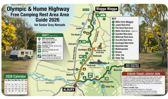
Every Rest Area on This Corridor — Complete Stop-by-Stop Guide
The following stop cards cover every rest area and free overnight stop on the Olympic Highway between Wagga Wagga and Albury, plus the key Hume Highway stops that connect to or parallel this corridor. Each card gives you the essential facts at a glance — click through to the full individual guide for complete GPS coordinates, facilities tables, medical contacts, packing checklists and seasonal advice specific to that location.
Stops are listed in order from north to south — Wagga Wagga to Albury. If you are travelling north, read from the bottom of this section upward.
Stop 1 — Uranquinty Rest Area
📍 Uranquinty Rest Area — Olympic Highway, Uranquinty NSW 2652
Uranquinty is the first rest stop south of Wagga Wagga on the Olympic Highway and makes an excellent early-morning vehicle check point before committing to the longer sections between towns. It is small and basic but useful as a fatigue management tool for travellers who left Wagga Wagga after a long drive the previous day and want to confirm their rig is road-ready before the quieter highway sections begin.
Read the Full Uranquinty Rest Area Guide →Stop 2 — Wagga Hill Rest Area
📍 Wagga Hill Rest Area — NSW
Wagga Hill Rest Area offers a slightly elevated position compared to the flat Riverina plain stops and is a quieter alternative for travellers who want to rest near Wagga Wagga without the full city environment. As with all stops on this corridor, self-containment is essential and facilities should be confirmed on arrival rather than assumed from any published source.
Read the Full Wagga Hill Rest Area Guide →Stop 3 — Wallacetown Rest Area
📍 Wallacetown Rest Area — NSW
Wallacetown Rest Area is one of the quieter and less well-known stops on this corridor — a useful addition to your planning list as a backup option if Uranquinty is full or if you need to break your driving day into shorter segments than the major stops allow. Confirm all current facilities on arrival and treat it as a self-contained stop with no assumptions about water or amenities.
Read the Full Wallacetown Rest Area Guide →Stop 4 — The Rock Rest Area
📍 The Rock Rest Area — Olympic Highway, The Rock NSW 2655
The Rock is one of the more interesting stops on the Olympic Highway corridor because the town sits at the foot of a striking granite outcrop — The Rock Nature Reserve — that gives the stop a different character to the flat Riverina plain. The town itself is small with limited services but the rest area provides a genuine sense of place. Confirm fuel and grocery availability before counting on them in town, and be aware that the nature reserve walking trails involve some elevation gain that may not be suitable for all senior mobility levels.
Read the Full The Rock Rest Area Guide →Stop 5 — Culcairn Rest Area
📍 Culcairn Rest Area — Olympic Highway, Culcairn NSW 2660
Culcairn sits at the approximate mid-point of the Olympic Highway section of this corridor and is the most useful overnight stop for travellers breaking the Wagga Wagga to Albury journey into two days. It is quieter than the Hume Highway alternatives, sits next to a small but genuine community, and offers a rest area that is functional and unpretentious. The full individual guide covers GPS, seasonal conditions, medical contacts and the honest heat management challenges of this exposed Riverina location in summer.
Read the Full Culcairn Rest Area Guide →Stop 6 — Henty Rest Area
📍 Henty Rest Area — Olympic Highway, Henty NSW 2658
Henty is a small agricultural service town with a proud local history as the birthplace of the stump-jump plough — an important piece of Australian agricultural heritage that makes for a genuinely interesting short stop for travellers with an interest in rural history. The rest area is useful as a final stopping point before Albury if you are arriving from the north and want to rest rather than navigate into a major city while fatigued. From Henty, Albury is approximately 35 km — close enough that Albury’s full medical, fuel and service infrastructure is within easy reach.
Read the Full Henty Rest Area Guide →Stop 7 — Holbrook Rest Area
📍 Holbrook Rest Area — Olympic Highway, Holbrook NSW 2644
Holbrook is the standout stop on the Hume Highway section of this corridor — not because its rest area facilities are exceptional, but because the town itself is genuinely interesting. The HMAS Otway submarine, displayed on land in the town park, draws visitors from across Australia and is a flat, accessible, free attraction that suits senior grey nomads looking for something more than a sealed rest area beside a highway. The town has fuel, food and limited shopping within easy walking distance of the central area. For travellers crossing between the Hume and Olympic highways, Holbrook is the most practical and interesting connection point.
Read the Full Holbrook Rest Area Guide →Stop 8 — Tarcutta Rest Area
📍 Tarcutta Rest Area — Hume Highway, Tarcutta NSW 2652
Tarcutta is one of the best-known rest stops on the NSW section of the Hume Highway and serves a large volume of travellers as the primary fatigue management stop between Wagga Wagga and the Holbrook area. The Hume Highway at Tarcutta is a divided carriageway, which means the entry to the rest area is directional — confirm your approach direction before committing. The rest area typically accommodates large vehicles including B-doubles and is generally spacious enough for caravan rigs. Its high-traffic nature means truck noise is a constant feature of overnight stays here.
Read the Full Tarcutta Rest Area Guide →Stop 9 — Gundagai Rest Area
📍 Gundagai Rest Area — Hume Highway, Gundagai NSW 2722
Gundagai sits at the northern end of the Hume Highway section covered by this guide and is one of Australia’s most storied inland towns — associated with the 1852 flood that killed more than 80 people and immortalised in poetry and song. The town itself is genuinely worth a visit for senior grey nomads with an interest in Australian history, with the Prince Alfred Bridge ruins, the Dog on the Tuckerbox monument and the town museum all within accessible distance. The rest area serves as a staging point for this historical exploration as much as a fatigue stop.
Read the Full Gundagai Rest Area Guide →Stop 10 — Junee Rest Area
📍 Junee Rest Area — Olympic Highway, Junee NSW 2663
Junee is one of the more rewarding small towns on the Olympic Highway corridor for senior grey nomads interested in railway history. The Junee Roundhouse — one of the largest surviving railway roundhouses in Australia — is a genuine heritage experience and is accessible in the township. The rest area serves travellers on the Olympic Highway north of Wagga Wagga and sits at a useful distance for breaking the Wagga Wagga to Cootamundra run into manageable segments.
Read the Full Junee Rest Area Guide →Stop 11 — Cootamundra Rest Area
📍 Cootamundra Rest Area — Olympic Highway, Cootamundra NSW 2590
Cootamundra is a genuine destination town for grey nomads who appreciate Australian sporting and cultural history — the Don Bradman Birthplace is a National Trust-listed heritage property in the town and is a flat, accessible and genuinely moving visit. The rest area provides an overnight base for exploring the town and the broader Cootamundra district. The Olympic Highway at Cootamundra is well-maintained and the town has full services including fuel, groceries and medical facilities.
Read the Full Cootamundra Rest Area Guide →Stop 12 — Albury Rest Area
📍 Albury Rest Area — Hume Highway, Albury NSW 2640
Albury is the southern anchor of this entire guide and the most service-rich town on the corridor. As a full regional city with two hospitals (Albury Base Hospital and Wodonga Hospital across the Murray River), full retail, multiple caravan parks and competitive fuel pricing, Albury is where every grey nomad on this corridor should resupply, refuel, fill their water tank and use a dump point before heading north on the Olympic Highway. The rest area on the Hume Highway provides the free overnight option for travellers who are passing through rather than staying — but with all the city’s services within 5 to 10 km, there is no reason to arrive at the rest area without having taken full advantage of Albury first.
Read the Full Albury Rest Area Guide →Best Time of Year for This Corridor
| Season | Olympic Highway Character | Hume Highway Character | Senior Verdict |
|---|---|---|---|
| Summer (Dec–Feb) | Very hot — Riverina temperatures regularly 38–42°C. No shade at rest areas. Bushfire risk elevated in surrounding farmland. | Hot but more managed by divided highway speed — rest areas with more shade infrastructure than Olympic stops in some locations. | Not recommended for rest area camping on either highway unless self-contained with adequate heat management. Powered sites in Wagga Wagga, Albury or major towns strongly recommended for seniors with heat-related health concerns. |
| Autumn (Mar–May) | Excellent — comfortable temperatures, golden Riverina landscape, reduced freight pressure after harvest season. | Excellent — comfortable driving temperatures, good visibility, lower holiday traffic than summer peak. | Highly recommended for both corridors. April is the single best month for this route. Conditions suit all senior fitness and health levels. |
| Winter (Jun–Aug) | Cold nights — frost possible in the Riverina. Fog at dawn near creek crossings. Olympic Highway undivided sections require extra care in reduced visibility. | Cold mornings — fog on the Hume Highway near Albury and the Murray River valley. Divided highway is safer in low visibility than the Olympic. | Manageable for well-equipped rigs with quality heating and bedding. Do not depart at dawn in fog — wait for full visibility. CPAP users ensure heated humidifier is functioning in cold conditions. |
| Spring (Sep–Nov) | Good but windy — the Riverina plain generates significant crosswinds in September and October that affect high-sided vans and motorhomes. | Good conditions — Hume Highway’s divided structure provides marginally more protection from crosswind gusts than the open Olympic. | Good overall — reduce towing speed in gusty conditions, widen following distances, and arrive early at rest areas during October peak season when competition for space is highest. |
Safety for Senior Grey Nomads on These Highways
Olympic Highway specific safety
- The Olympic Highway is an undivided two-lane rural highway between Wagga Wagga and Albury — head-on crash risk is statistically higher than on divided highways; fatigue management is not optional on this road
- Livestock near the road is a genuine risk in the farming areas around The Rock, Culcairn and Henty — reduce speed at dawn and dusk and stay alert on approaches to towns
- Rest area entries on an undivided highway require more planning than on a divided freeway — begin slowing early, signal clearly and do not panic-brake with a caravan attached
- If you miss a rest area entry on the Olympic Highway, continue safely to the next town or rest area — do not attempt a U-turn on a rural highway
Hume Highway specific safety
- The Hume Highway is a divided freeway for most of its length through this region — rest area entries are directional, well-signed and clearly delineated from the live traffic lanes
- Speed on the Hume is 110 km/h in open sections — with a caravan, your effective safe towing speed should be governed by your rig’s stability, not the posted limit
- Heavy freight volume on the Hume is significantly higher than on the Olympic — truck wake turbulence when towing can be significant; maintain safe following distances from B-doubles
- Fog near the Albury–Wodonga Murray River corridor can be dense at dawn in winter — do not depart from the Albury Rest Area or any nearby stop before full daylight in foggy conditions
Solo senior traveller safety on both corridors
- Always inform someone of your planned stops for the day before you depart your morning camp — a simple text message with your planned route and overnight destination
- Carry a personal locator beacon (PLB) registered with AMSA if you are travelling regularly on rural highways — the investment is modest and the peace of mind is significant
- Keep a 48-hour supply of all prescription medications accessible inside your vehicle cab, not only in the caravan body
- Trust your instincts at rest areas — if the environment does not feel right on arrival, relocate; you owe no explanation to anyone and your safety is always the priority
For detailed caravan security advice relevant to all stops on this corridor, read How Caravan Theft Happens in Australia — Grey Nomad Guide. For full route planning tools, visit Best Routes to Drive Around Australia for Grey Nomads.
Frequently Asked Questions
What is the best free overnight stop between Wagga Wagga and Albury on the Olympic Highway?
For most senior grey nomads, the Culcairn Rest Area is the most practical mid-corridor overnight stop between Wagga Wagga and Albury on the Olympic Highway. It sits approximately halfway between the two cities, is quieter than the Hume Highway alternatives, and is adjacent to a small community which many solo travellers find reassuring. In summer, however, the fully exposed Riverina location at Culcairn is a heat management challenge — in that season, a powered site in either city may be the better choice. The Rock Rest Area is a good alternative for travellers who want to break the journey earlier in the day.
Is the Olympic Highway between Wagga Wagga and Albury suitable for caravans?
Yes — the Olympic Highway between Wagga Wagga and Albury is a sealed, two-lane rural highway that is suitable for caravans and motorhomes of all standard sizes. It is not a freeway and does not have the divided carriageway safety features of the Hume Highway, so experienced towing skills and attentive driving are required. The road is generally in reasonable condition but can have rough patches, stock crossings and narrow sections near some town approaches. Large rigs should reduce speed on the undivided sections and allow for the fact that overtaking opportunities for following vehicles are limited — be considerate and use turnouts where available.
Which is better for senior grey nomads — the Olympic Highway or the Hume Highway?
The honest answer is that it depends on what you value in a journey. The Hume Highway is faster, wider, better signed and better serviced with truck stop fuel and facilities — it is the easier and arguably safer choice for senior travellers towing large rigs or travelling solo for the first time. The Olympic Highway through Wagga Wagga and the southern Riverina towns offers a quieter, more characterful experience through genuine country towns and flat open farmland. Many experienced grey nomads do a loop — south on the Hume, north on the Olympic (or vice versa) — to get the best of both. If this is your first time through the region, the Hume is the less stressful option.
Are there dump points along the Olympic Highway between Wagga Wagga and Albury?
There are no dump points at the rest areas themselves on the Olympic Highway between Wagga Wagga and Albury. Dump point facilities need to be accessed in the township of Wagga Wagga before heading south, or in Albury after arriving. Use the WikiCamps Australia app or the Camps Australia Wide app to confirm the current nearest active dump point location before you need to use it. Never discharge grey or black water at a highway rest area — this is the single fastest way to get rest areas closed permanently.
How far is it between fuel stops on the Olympic Highway south of Wagga Wagga?
The distances between reliable fuel stops on the Olympic Highway between Wagga Wagga and Albury are not extreme by outback standards, but rural service stations have variable opening hours and should never be treated as guaranteed. The practical advice is to fill your tank in Wagga Wagga before heading south and treat any fuel you find in Uranquinty, The Rock, Culcairn or Henty as a top-up opportunity rather than your planned fuel stop. From a full tank in Wagga Wagga, any standard caravan rig should reach Albury without difficulty — the route is approximately 120 km. Fill up in Albury at competitive city pricing before heading north.
What is the nearest hospital to the mid-point of the Olympic Highway corridor?
The mid-point of the Olympic Highway between Wagga Wagga and Albury is approximately the Culcairn area. From there, Albury Base Hospital at 201 Borella Road, Albury NSW 2640 — phone (02) 6058 4444 — is approximately 55 km south, and Wagga Wagga Base Hospital at Docker Street, Wagga Wagga NSW 2650 — phone (02) 6938 6666 — is approximately 65 km north. In a medical emergency, call 000 immediately and let the emergency services direct you — do not attempt to drive yourself to hospital.
Can I get mobile phone coverage between towns on the Olympic Highway?
Mobile coverage between towns on the Olympic Highway is variable and unreliable on some carriers. Telstra provides the best rural coverage on this corridor and is the recommended carrier for senior travellers who rely on mobile connectivity for medical apps, emergency contact or navigation. Optus coverage between towns is patchy. Vodafone coverage is poor. Download your complete route offline before leaving any major town and do not rely on mobile data being available at rest areas between Wagga Wagga and Albury.
Is it safe for solo senior women to use the rest areas on this corridor?
The rest areas on the Olympic Highway through the southern Riverina generally attract a mix of grey nomad travellers, truck drivers and local road users — they are not typically problematic locations. That said, no rest area on any highway can be unconditionally declared safe for solo travellers at all times. The practical guidance is the same as for any rural stop: trust your instincts on arrival, lock your vehicle and caravan before sleeping, send a location update to your emergency contact, keep your phone charged, and be prepared to relocate to a paid site in the nearest town if the rest area does not feel right. The short distances to Wagga Wagga and Albury mean that a paid alternative is always within reach on this corridor.
Final Verdict — Planning Your Journey
The Olympic Highway and Hume Highway corridors between Wagga Wagga and Albury represent one of the most accessible and well-documented grey nomad routes in inland New South Wales. The combination of twelve identified free rest areas and overnight stops, two full-service regional cities at each end of the route, and the choice between a quiet rural highway and a modern freeway gives senior travellers a genuinely flexible planning environment. This is not remote Australia — it is a well-serviced corridor where careful planning eliminates most risks and where the distances between services, while real, are manageable for a well-prepared self-contained rig.
The honest caveats are equally important. No rest area on this corridor is a campground. None has power, dump points or reliable potable water. Summer on the Riverina plain is genuinely challenging for senior travellers without shade and air conditioning. The mid-corridor distance from major hospitals is a real consideration for travellers with acute health conditions. And the rural service station hours between towns mean that fuel planning must be done in advance, not on the fly. Plan well, arrive with full tanks of fuel and water, carry your medications in the cab, download your maps offline, and you will find this one of the most pleasant and rewarding stretches of inland NSW to travel. Arrive underprepared, and the gaps between services will find you.
For complete route planning across Australia, visit Best Routes to Drive Around Australia for Grey Nomads. For all free stop coordinates and planning tools for this and every other corridor, bookmark Vanlife Savings Spots.
COPY PROMPT ➔ ASK AI ➔ SAVE TO FORM ➔ ADD SPOT PIN ➔ GET DIRECTIONS
📍 Interactive map — find free camps, rest areas and overnight stops along the Olympic and Hume Highway corridors. Enable location for best results.
- Uranquinty Rest Area — Olympic Highway, south of Wagga Wagga
- Wagga Hill Rest Area — NSW
- Wallacetown Rest Area — NSW
- The Rock Rest Area — Olympic Highway, The Rock NSW
- Culcairn Rest Area — Olympic Highway, Culcairn NSW
- Henty Rest Area — Olympic Highway, Henty NSW
- Holbrook Rest Area — Hume Highway, Holbrook NSW
- Tarcutta Rest Area — Hume Highway, Tarcutta NSW
- Gundagai Rest Area — Hume Highway, Gundagai NSW
- Junee Rest Area — Olympic Highway, Junee NSW
- Cootamundra Rest Area — Olympic Highway, Cootamundra NSW
- Albury Rest Area — Hume Highway, Albury NSW
Free campsites and powered sites fill fast during school holidays and peak season. If your preferred site is already gone, search remaining accommodation options below to explore the region.
Accommodation and flight search powered by Expedia. Booking through this search supports this website at no extra cost to you. As an affiliate, I earn from qualifying purchases at no extra cost to you.

As an affiliate, I earn from qualifying purchases at no extra cost to you.
Exclusive Offer: Get 5% OFF all StarterStopper immobiliser products with promo code: RTV5
Visit StarterStopper.com to see our data-backed security solutions
As an affiliate, I earn from qualifying purchases at no extra cost to you.