Narooma Rest Areas — Free Camping Guide 2026 Senior Grey Nomad
GPS-verified guide to Narooma rest areas, Wagonga Inlet foreshore overnight parking and free camping options for senior grey nomads on the NSW South Coast Princes Highway — covering facilities, dump points, Narooma MPS hospital contacts, Montague Island and Eurobodalla day trips with honest overnight rules for 2026.
📅 Last reviewed: April 2026 | Narooma NSW 2546 | Princes Highway (A1) | Access and overnight rules subject to Eurobodalla Shire Council and NSW Roads signage on arrival
Narooma is widely regarded as one of the most beautiful towns on the entire NSW South Coast — a small coastal settlement perched on a dramatic rock bar entrance where Wagonga Inlet meets the ocean, with Montague Island visible offshore and one of the finest natural harbour views of any Australian coastal town. For senior grey nomads, Narooma is far more than a scenic photo stop. It is a genuine service checkpoint at the 360-kilometre mark south of Sydney, with a supermarket, dump point, MPS hospital, caravan parks and a range of accessible foreshore stops that make it one of the corridor’s most important overnight decision points before the drive continues south into increasingly remote Far South Coast territory.
- Location: Narooma, Eurobodalla Shire, NSW South Coast
- State: NSW
- Highway: Princes Highway (A1)
- Use: Day-use foreshore stops; some overnight options at inlet foreshore — verify current signage on arrival
- Best for: Scenic rest stop, whale and seal watching, Montague Island tours, resupply before Far South Coast, Wagonga Inlet foreshore walk
- Toilets: Yes — Wagonga Inlet foreshore, Bar Beach reserve, Narooma town centre and Princes Highway rest areas
- Dump point: Available in the Narooma area — confirm exact location via Campermate or WikiCamps
- Potable water: Not confirmed at roadside stops — carry your own supply
- Power: No powered sites at public rest areas
- Phone signal: Adequate Telstra in Narooma township; variable on highway north toward Moruya and south toward Bermagui junction
- Nearest town: Narooma NSW 2546
- Nearest major services: Narooma CBD — supermarket, fuel, pharmacy, hospital, caravan services within the town
Table of Contents
- Location, address and GPS
- Can you stay overnight at Narooma?
- Facilities: toilets, water, bins and dump point
- Nearby public Wi-Fi and mobile coverage
- How to get there
- What to expect on arrival
- Safety for senior grey nomads
- Medical and emergency contacts
- Dump points, water and supplies nearby
- Things to do for seniors in the area
- Best time of year to stop here
- Fires, generators and overnight etiquette
- Packing checklist for seniors
- GPS coordinates and postcodes: save every stop
- Frequently Asked Questions
- Quick verdict
Section 1 — Location, address and GPS
Narooma sits at a dramatic coastal position where Wagonga Inlet — a long tidal inlet stretching inland through bush and wetland — meets the Pacific Ocean across a narrow rock bar. The Princes Highway passes directly through the town, crossing the inlet on the Narooma Bridge before continuing south toward Bermagui and Bega. The town itself is compact and built on a narrow headland between the ocean and the inlet — a topography that gives Narooma an almost peninsular character and contributes to the extraordinary scenery that makes it so memorable for travellers arriving from either direction.
For grey nomads, the key stopping points are the Wagonga Inlet foreshore reserve south of the bridge, Bar Beach and the rock bar entrance area, the Princes Highway rest areas on the northern and southern approaches, and the town centre itself which sits directly on the highway.
Primary GPS Reference — Wagonga Inlet Foreshore Reserve
−36.2175° S, 150.1339° E
Wagonga Inlet foreshore reserve, Bluewater Drive, Narooma NSW 2546 — south of the Narooma Bridge, adjacent to the inlet and the Bar Beach walking track
Secondary GPS — Bar Beach Reserve and Rock Bar Lookout: −36.2218° S, 150.1389° E
Secondary GPS — Narooma town centre / Princes Highway: −36.2147° S, 150.1296° E
Secondary GPS — Princes Highway rest area (north approach, Tilba Tilba area): −36.1812° S, 150.1134° E
Secondary GPS — Apex Park foreshore (Wagonga Inlet north side): −36.2096° S, 150.1278° E
| Detail | Information |
|---|---|
| Primary address | Wagonga Inlet foreshore reserve, Bluewater Drive, Narooma NSW 2546 |
| Highway | Princes Highway (A1) — Narooma is directly on the highway |
| Council | Eurobodalla Shire Council |
| Postcode | 2546 (Narooma, Dalmeny, Kianga, Mystery Bay, Central Tilba) |
| Region | Eurobodalla — NSW South Coast |
| Distance south of Sydney | Approximately 360km via Princes Highway |
| Distance south of Moruya | Approximately 40km via Princes Highway |
| Distance south of Batemans Bay | Approximately 75km via Princes Highway |
| Distance north of Bermagui | Approximately 32km via Princes Highway then Bermagui Road |
| Distance north of Bega | Approximately 80km via Princes Highway |
| Offshore feature | Montague Island — approximately 9km offshore, accessible via boat tour from Narooma |
For the complete South Coast corridor GPS directory from Wollongong to Eden, see our Vanlife Savings Spots guide — updated regularly with current overnight rules and facility notes for senior grey nomads.
Section 2 — Can you stay overnight at Narooma?
Narooma sits within the Eurobodalla Shire, which has been one of the more progressive NSW South Coast councils in its attitude toward self-contained vehicle camping. The honest current picture as at April 2026 involves a range of options across the broader Narooma area — from day-use-only foreshore reserves to specific locations where overnight stays for self-contained vehicles have been formally or informally accommodated. This section gives you the full honest picture.
- The Wagonga Inlet foreshore reserve (Bluewater Drive, south of the bridge) has historically been one of the most grey-nomad-friendly stops on the corridor — some sections of the foreshore car park have had signage permitting overnight stays for self-contained vehicles for limited periods. This must be confirmed against current signage on arrival — the rules have changed periodically and cannot be relied upon from older information.
- Apex Park on the north side of the inlet (accessible from Princes Highway) is a pleasant foreshore area that has also been used informally for overnight stops by self-contained travellers — verify current Council signage before assuming this is permitted.
- Bar Beach reserve is a day-use area — not suitable for overnight stays.
- Eurobodalla Shire Council maintains a list of designated free camping locations within the shire — check the Council website, Campermate and WikiCamps for current confirmed free camping GPS references in the Narooma area before your visit.
- Dalmeny, approximately 8km north of Narooma on the Princes Highway, has foreshore camping options that have been popular with grey nomads — confirm current status via Campermate.
- Multiple caravan parks operate in Narooma — powered and unpowered sites available, booking is essential for October long weekend, school holidays and the Easter period.
Section 3 — Facilities: toilets, water, bins and dump point
Narooma has better public facilities than most South Coast towns of comparable size. The combination of its tourist appeal, its role as an Eurobodalla Shire service hub and its significant grey nomad traffic has resulted in Council investment in foreshore amenities that exceed what you might expect for a town of approximately 3,000 permanent residents.
| Facility | What is available | What seniors should know |
|---|---|---|
| Toilets | Yes — public toilets at the Wagonga Inlet foreshore (Bluewater Drive), Bar Beach reserve, Apex Park, the town centre precinct and the Princes Highway rest area north of town. Multiple accessible toilet blocks throughout the foreshore area. | The Wagonga Inlet foreshore toilets are among the better-maintained public toilet facilities on the corridor at this point — Council investment reflects the high grey nomad traffic. The Princes Highway rest area toilets are maintained by NSW Roads and are reliably available 24 hours. Accessible facilities are confirmed at the main foreshore block. |
| Potable water | Not confirmed at foreshore or highway rest area stops — some foreshore parks have tap water but these are not consistently labelled as potable drinking water | Carry a minimum 20-litre sealed drinking water supply. Refill at Narooma supermarket (Woolworths) before continuing south — Narooma is the last town with a large supermarket before Bega approximately 80km south. South of Narooma, water resupply options reduce significantly. |
| Dump point | A dump point is available in the Narooma area — confirm exact current location and access hours via Campermate or WikiCamps before visiting | Critical checkpoint — Narooma is the last reliable dump point before the Narooma–Bermagui–Bega section of the corridor. Do not pass through Narooma with a full or near-full holding tank. The section south involves 80km to Bega with limited intermediate dump point options. |
| Showers | No showers at foreshore rest areas — Narooma Pool complex near the inlet has shower facilities accessible during pool opening hours; bar beach change rooms have basic beach rinse facilities | The Narooma Pool (open seasonally) is the most practical shower option near the foreshore. Confirm opening hours and public access before planning a shower stop here. Caravan parks in Narooma offer shower facilities for guests. |
| Bins | Yes — bins at the Wagonga Inlet foreshore, Bar Beach, Apex Park, town centre and the Princes Highway rest area. Generally well-maintained due to high grey nomad traffic. | Bins are serviced regularly on a Council schedule. Can overflow during October long weekend and school holidays when Narooma receives significant tourist volumes. Always take rubbish with you if bins are unexpectedly full. |
| Power | No powered sites at any Narooma public rest area or foreshore park | CPAP users must carry a battery pack or inverter for overnight stops at public rest areas. Multiple caravan parks in Narooma offer powered sites — book well in advance for October long weekend, Easter and school holiday periods, which see extremely high demand at Narooma parks. |
Section 4 — Nearby public Wi-Fi and mobile coverage
Narooma has reasonable mobile coverage for a small coastal town of its size and position on the mid-South Coast, though the coverage picture changes significantly as you move out of the town centre — particularly on the coastal roads south toward Bermagui and on the inland roads toward Central Tilba and Cobargo.
- Telstra: Good 4G coverage throughout Narooma township, the foreshore precinct and the inlet areas. Coverage on the Princes Highway north toward Moruya is moderate. Coverage south of Narooma on the highway toward Cobargo and Bermagui is variable with genuine gaps through the Eurobodalla hinterland sections.
- Optus: Adequate 4G in the Narooma town centre. Drops off more noticeably on the coastal access roads and on the highway south toward Bermagui junction. Not recommended as a primary provider for navigation south of Narooma.
- Vodafone/TPG: Functional in the main town centre — significantly less reliable on the foreshore outer areas and the highway approaches in both directions.
- Free public Wi-Fi: Available at Narooma Library (Princes Highway, Narooma) during opening hours — free internet and computer access for seniors managing banking, telehealth, medication orders or family video calls. One of the most important free connectivity resources on the corridor at this latitude.
- Narooma Library: A particularly valuable resource for grey nomads stopping here — air-conditioned, comfortable and equipped with computer terminals and free Wi-Fi. Open Monday to Friday.
- Narooma Golf Club and various cafés: Some visitor Wi-Fi available — useful backup if library is closed.
Section 5 — How to get there
Narooma is directly on the Princes Highway and is straightforward to approach from both north and south. The town’s compact layout means most services and foreshore areas are within a short distance of the main highway. The key navigation decision is which foreshore area to target — the inlet south of the bridge (Wagonga Inlet foreshore / Bluewater Drive) is the most popular grey nomad stop, while Apex Park on the north side of the bridge offers a quieter and less-visited alternative.
From Moruya / Batemans Bay (heading south): Follow the Princes Highway south through Bodalla and the Eurobodalla hinterland. The highway descends gently toward the coast and the Narooma Bridge crossing becomes visible ahead. Cross the bridge and continue into the Narooma town centre. Turn left onto Bluewater Drive immediately south of the bridge to reach the Wagonga Inlet foreshore reserve. For Apex Park, do not cross the bridge — turn right off the highway before the bridge onto Forsters Bay Road.
From Bermagui / Bega (heading north): Follow the Princes Highway north through Tilba Tilba and the approach to Narooma. The highway crosses the Narooma Bridge — the inlet and ocean views open up dramatically as you cross. Turn right onto Bluewater Drive immediately after crossing the bridge heading south-to-north to access the foreshore reserve.
Driving notes for seniors towing vans
- The Narooma Bridge is a standard two-lane bridge — manageable for caravans and motorhomes but requires attention to oncoming traffic particularly when large vehicles cross simultaneously
- Bluewater Drive from the Princes Highway to the inlet foreshore is a narrow suburban road in sections — assess carefully before committing with a very large rig; the foreshore car park itself is flat and spacious enough for most vans
- The Princes Highway south of Narooma toward the Bermagui junction (approximately 32km) involves winding coastal hinterland terrain — reduce speed and maintain a safe following distance, particularly behind trucks heading south to Bega
- The access road to Central Tilba (approximately 15km south of Narooma) is steep and narrow — not suitable for caravans or large motorhomes; visit Central Tilba by tow vehicle or car only
- Fuel in Narooma is available from service stations on the Princes Highway — fill up completely here before continuing south; prices increase progressively on the Far South Coast
- The Princes Highway through Narooma town centre has pedestrian crossings, school zones and roundabouts — slow down through the town section regardless of posted limits
Section 6 — What to expect on arrival
Arriving in Narooma for the first time is one of those corridor moments that stops you mid-thought. The Narooma Bridge crossing delivers an extraordinary simultaneous view — Wagonga Inlet stretching inland to the west, the Pacific Ocean to the east, and the narrow rock bar entrance between them where seals haul out on the exposed rock platforms. If you are coming from the north after the long Batemans Bay–Moruya–Narooma run, the sight is both beautiful and restorative. The town itself is small, unpretentious and entirely comfortable with its own exceptional beauty.
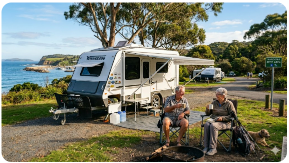
- The Wagonga Inlet foreshore reserve is the main grey nomad gathering point — a flat grassed area with excellent inlet views, picnic tables, toilets, boat ramp access and the Bar Beach walking track leading to the rock bar lookout
- The foreshore is popular but manages its visitor numbers better than the larger tourist towns to the north — even on busy weekends, the inlet foreshore retains a relatively peaceful atmosphere compared to the Batemans Bay crowd levels
- The seal colony at the Narooma rock bar entrance is visible from the Bar Beach walking track — often 20 or more Australian fur seals hauled out on the rocks within easy viewing distance; this is one of the most reliably accessible seal viewing locations on the NSW South Coast
- The town centre is compact and accessible from the foreshore — the short walk from Bluewater Drive to the Princes Highway shops is flat and suitable for most senior mobility levels
- October long weekend brings significant visitor volumes to Narooma — the town hosts the Narooma Oyster Festival during this period, which is both a draw and a parking challenge
Section 7 — Safety for senior grey nomads
Personal safety
- Narooma is a genuinely safe and welcoming town for senior grey nomads — crime rates are low and the community has a long-established relationship with grey nomad visitors that is generally positive and respectful
- The Wagonga Inlet foreshore car park is well-used and relatively visible — a reasonable overnight stopping environment compared to more isolated locations; park in the main lit section near the toilet block for the best visibility
- The Bar Beach walking track to the rock bar involves some uneven coastal terrain — seniors with balance or mobility concerns should assess the track surface before committing to the walk toward the bar entrance; the upper lookout areas are accessible without technical difficulty
- Do not leave valuables visible in your vehicle at the foreshore car park — opportunistic theft from vehicles does occur at popular coastal car parks, even in smaller towns like Narooma, particularly during busy holiday periods
- The inlet foreshore at night is dark in most sections — use a torch for any after-dark walking near the water and stay well back from the water’s edge and the boat ramp area
Trip safety
- Before departing Narooma heading south, download offline maps and check NSW Live Traffic — the Princes Highway south of Narooma through Tilba Tilba, Cobargo and the approach to Bega is a winding rural road with limited alternative routes and variable mobile coverage
- Kangaroo and wallaby activity on the Princes Highway south of Narooma is significant at dusk and dawn through the forested sections toward Cobargo — plan your departure to arrive at Bermagui or Bega before dusk
- The Narooma MPS hospital is an important stop for senior travellers with health concerns — assess your condition honestly before continuing south into the more remote Far South Coast section where emergency services response times increase significantly
- South of Narooma the corridor becomes genuinely remote — ensure your PLB (Personal Locator Beacon) or satellite communicator is accessible and registered before continuing
For comprehensive guidance on protecting your caravan at foreshore and inlet car parks — one of the most common theft scenarios on the South Coast — see our guide on how caravan theft happens in Australia.
Section 8 — Medical and emergency contacts
| Service | Address | GPS | Phone |
|---|---|---|---|
| Narooma MPS Hospital (ED) | Graham Street, Narooma NSW 2546 | −36.2176° S, 150.1278° E | (02) 4476 2811 |
| Batemans Bay Hospital (Full ED) | Bass Avenue, Batemans Bay NSW 2536 | −35.7052° S, 150.1682° E | (02) 4493 2155 |
| Emergency (Police/Fire/Ambulance) | All locations | — | 000 |
| Healthdirect (nurse on call 24hr) | Phone service only | — | 1800 022 222 |
| NSW Police — Narooma | 96 Princes Highway, Narooma NSW 2546 | −36.2155° S, 150.1299° E | (02) 4476 2899 |
Section 9 — Dump points, water and supplies nearby
There is no dump point at the Wagonga Inlet foreshore reserve or at any Narooma public park. However, a dump point is available in the Narooma area and is one of the most critically important service stops on the entire corridor — it is the last reliable dump point before the Bermagui detour and the 80-kilometre drive to Bega. Use it without exception when passing through Narooma.
| Need | Best nearby option | Notes |
|---|---|---|
| Dump point | Narooma area dump point — confirm exact current location and access hours via Campermate or WikiCamps before visiting | Do not pass Narooma heading south with a full or near-full holding tank under any circumstances. The section to Bega (80km) and via Bermagui (detour road) has very limited dump point options. This is arguably the most important dump point stop on the entire Wollongong to Eden corridor for southbound travellers. |
| Fresh water | Narooma Woolworths (Princes Highway, Narooma); service stations on Princes Highway through town | Narooma Woolworths is the last large-format supermarket before Bega. Purchase sealed water containers here and carry a minimum 20-litre supply for the Far South Coast section. Bermagui and Cobargo have very limited water resupply options. |
| Groceries and fuel | Narooma Woolworths (Princes Highway); IGA alternatives; multiple service stations on Princes Highway through town | Stock up fully at Narooma — this is the last Woolworths before Bega approximately 80km south. Fuel prices in Narooma are moderate — fill completely before continuing. The remote Far South Coast section has limited fuel options at competitive prices. |
| Major supplies (pharmacy, LPG, hardware) | Narooma pharmacy (Princes Highway); LPG cylinder exchange at service stations; limited hardware at town stores | Fill all prescriptions in Narooma. Exchange LPG cylinders here. Any specialist hardware or caravan equipment should be sourced here or in Batemans Bay — options south of Narooma reduce significantly. Bega has a Bunnings if you need hardware, but that is 80km south. |
| Alternative nearby stop | Dalmeny NSW 2546 (~8km north — foreshore camping options); Central Tilba NSW 2546 (~15km south via Tilba Road — heritage village, no major services); Bermagui NSW 2546 (~32km south via detour) | Dalmeny foreshore camping is worth checking via Campermate for confirmed current options. Central Tilba is a heritage village worthy of a visit but has no grey nomad services. Bermagui is worth the detour for the village experience but has limited services compared to Narooma. |
For strategic guidance on planning caravan park stays and free camping stops across the full Far South Coast section, see our guide on how long you can stay in a caravan park in Australia.
Section 10 — Things to do for seniors in the area
Narooma and the surrounding Eurobodalla region offer some of the most extraordinary senior-friendly experiences on the entire NSW South Coast corridor. The combination of wildlife, coastal scenery, heritage villages and accessible foreshore walking makes Narooma a stop that genuinely warrants a two to three night stay for travellers who have the time.
| Activity | Location | Why seniors like it |
|---|---|---|
| Seal Watching at the Rock Bar | Bar Beach walking track, Narooma NSW 2546 | Australian fur seals haul out on the rock bar entrance year-round — one of the most reliably accessible seal viewing locations on the east coast. The walk from the foreshore car park is short and mostly flat. No boat required. No entry fee. Genuinely extraordinary wildlife encounter. |
| Wagonga Inlet Foreshore Walk | Bluewater Drive foreshore, Narooma NSW 2546 | Flat, accessible foreshore path along the inlet with outstanding water views — suitable for most senior mobility levels. Excellent birdwatching including black swans, pelicans and various waders. Picnic tables, toilets and shade trees throughout. |
| Montague Island Tour | Departs from Narooma Wharf — bookings via local tour operators | Day boat tour to Australia’s premier fur seal and seabird colony — accessible for most seniors as the boat transfer is straightforward. The island has Australian fur seals in their thousands, Little penguins (seasonal), shearwaters and the historic lighthouse. One of the most remarkable wildlife experiences on the east coast — book well in advance during October and school holidays. |
| Central Tilba Heritage Village | Bate Street, Central Tilba NSW 2546 (~15km south via Tilba Road) | Australia’s best-preserved 19th-century dairy village on the slopes of Mount Gulaga — National Heritage listed, completely flat village street, excellent craft galleries, cheese factory, café and pub. Accessible from the car park by a short flat walk. Not suitable for caravans on the approach road — visit in tow vehicle. |
| Whale and Dolphin Watching | Narooma headland lookouts and Bar Beach | Humpback whales are visible from the Narooma headland during both the northward (May–August) and southward (September–November) migrations. Bottlenose dolphins are regularly seen in Wagonga Inlet year-round. No boat, no fee, no advance planning required — just binoculars and patience. |
Best senior-friendly ideas at Narooma
- Walk the Bar Beach track to the rock bar at low tide in the morning — the seals are most active and most visible in the morning hours and the low tide exposes more of the rock platform. Allow 45–60 minutes return at a comfortable senior pace.
- Book a Montague Island tour at least one week in advance — during October and school holidays, tours fill weeks ahead. This is the single finest wildlife experience accessible from Narooma and is worth planning your entire stop around.
- Drive the 15 kilometres to Central Tilba in your tow vehicle on a weekday morning — arrive before 10am when the village is quiet and the light on Mount Gulaga is at its best. Buy a piece of local tilba cheese and eat it on the village green.
- Sit at the Wagonga Inlet foreshore at dusk and watch for dolphins in the inlet — bottlenose dolphins use the inlet regularly and sightings from the foreshore are genuinely common. This costs nothing and requires nothing but a comfortable chair and the patience to wait.
- Visit the Narooma Oyster Festival if your timing aligns with the October long weekend — it is crowded but the local oysters, the live music and the community atmosphere make it one of the South Coast’s finest events.
For an honest month-by-month account of what extended grey nomad van life actually feels like — including the extraordinary days like Narooma alongside the harder ones — read our guide on living in a camper.
Section 11 — Best time of year to stop here
| Season | What it is like | Senior verdict |
|---|---|---|
| Summer (Dec–Feb) | Warm to hot (22–28°C), school holiday crowds increase significantly but Narooma manages visitors better than larger tourist towns. The inlet foreshore is generally accessible but caravan parks fill completely for January. Montague Island tours can be booked out weeks ahead. Summer storms and strong northeasterly swells. | Manageable for experienced grey nomads who book caravan parks in advance and arrive before 9am at the foreshore. The Narooma Oyster Festival in October is a highlight but the general summer holiday period is busy. Mid-week arrival in late January or early February is significantly better than peak January school holiday fortnight. |
| Autumn (Mar–May) | Excellent — warm days (17–24°C), low humidity, stable coastal weather, dramatically reduced crowds. The inlet foreshore at its most peaceful. Montague Island tours available with much better booking accessibility. April is arguably the finest month of the year at Narooma. | Highly recommended — the best season overall for Narooma. Autumn brings ideal conditions for every activity this stop offers: foreshore walking, seal watching, Montague Island tours, Central Tilba visits and whale watching on the northward migration tail (May). April and May are outstanding months to be here. |
| Winter (Jun–Aug) | Mild coastal winters (9–16°C daytime), occasional cold fronts and southerly swells, very few tourists. Northward humpback whale migration peak (June–August) makes this the best whale watching season. Seals are present year-round. Narooma in winter has a genuinely quiet, unhurried character. | Excellent for whale watching enthusiasts and for grey nomads who value solitude over sunshine. Montague Island tours continue in winter and are significantly less crowded. Cold overnight temperatures require adequate van heating or warm sleeping equipment. The combination of whale migration peak, empty foreshore and off-peak caravan park pricing makes winter a genuinely compelling season here. |
| Spring (Sep–Nov) | Warming temperatures (14–23°C), southward humpback migration (September–November) overlaps with the Oyster Festival (October long weekend), building tourist numbers through November. Some spring storm systems in September. | Outstanding — particularly September and October. The southward whale migration combined with the Oyster Festival in October makes this arguably the finest month of the year at Narooma for senior travellers who enjoy a community event. Book accommodation and Montague Island tours well in advance for October. September is excellent for whale watching with fewer crowds than October. |
Section 12 — Fires, generators and overnight etiquette
Narooma’s public foreshore areas and rest stops are managed by Eurobodalla Shire Council under the same regulations that apply across the shire. Given Narooma’s significant grey nomad traffic, Council enforcement is active and the community is watchful — good behaviour here has a direct relationship with continued access at the foreshore locations that grey nomads value most.
- Open fires of any kind are prohibited at all Eurobodalla Shire Council foreshore reserves and parks — this includes the Wagonga Inlet foreshore, Bar Beach, Apex Park and all associated public areas, regardless of conditions or season
- Portable gas stoves used for cooking in designated picnic areas during daylight hours are generally tolerated — use them at the designated picnic tables, not in the car park itself or near the boat ramp
- Generators are not appropriate at the Wagonga Inlet foreshore — the foreshore is adjacent to residential properties on the inlet fringe and generator noise carries clearly across the water; complaints will result in ranger attendance
- If an overnight stay is occurring at a foreshore location where it is currently permitted or tolerated under signage (verify on arrival), set up with complete minimal footprint — no chairs, tables or awnings deployed in a way that signals a permanent camp in a shared public space
- All wastewater must be retained in your vehicle and emptied at the designated dump point — Wagonga Inlet supports significant aquaculture including oyster leases; any wastewater discharge near the inlet is both illegal and directly damaging to the local marine environment and livelihoods
- The inlet foreshore is used daily by local residents walking, kayaking and fishing — be genuinely respectful of the space as a shared community resource, not just a convenient parking spot
Section 13 — Packing checklist for seniors stopping at Narooma
| Item | Why it matters at Narooma | ☐ |
|---|---|---|
| Sealed drinking water (min 20L) | Last large supermarket water resupply before Bega — fill 20 litres here from Woolworths; do not rely on foreshore taps | ☐ |
| Medication supply (14+ days) | Narooma pharmacy is the last reliable dispensing point before Bega (~80km south) — fill all repeats here | ☐ |
| CPAP battery pack or inverter | No powered sites at public rest areas — battery essential for foreshore overnight stops; book caravan park powered sites for medical equipment needs | ☐ |
| Offline maps downloaded (to Eden) | Download the full Far South Coast corridor map — Narooma to Eden — while 4G is available here; coverage gaps increase significantly south of Narooma | ☐ |
| PLB or satellite communicator checked | South of Narooma the corridor becomes genuinely remote — ensure your PLB is registered and accessible before continuing | ☐ |
| Full fuel tank | Fuel in Narooma is the last competitively priced stop before Bega — fill completely here | ☐ |
| LPG cylinders filled | LPG exchange becomes inconsistent between Narooma and Bega — fill at Narooma service stations | ☐ |
| Dump station completed | Most critical dump point stop on the southbound corridor — do not pass Narooma without using it | ☐ |
| Binoculars | Essential for seal watching at the rock bar, whale watching from the headland and Montague Island spotting from shore | ☐ |
| Montague Island tour booked | Tours sell out weeks in advance during October and school holidays — book before you arrive or at least as soon as you reach Narooma for next-day availability | ☐ |
COPY PROMPT ➔ ASK AI ➔ SAVE TO FORM ➔ ADD SPOT PIN ➔ GET DIRECTIONS
📍 Interactive map — find free camps, rest areas and overnight stops near Narooma. Enable location for best results.
Section 14 — GPS coordinates and postcodes: save every stop
Save all of these coordinates before leaving Narooma heading south. The Far South Coast section from Narooma to Bega is 80 kilometres of rural and coastal highway with limited services and increasing mobile coverage gaps. Knowing your next hospital, dump point and fuel stop before you need them is essential on this section. For the complete South Coast corridor GPS directory, see our Vanlife Savings Spots guide.
| Location | Address + Postcode | GPS | Notes |
|---|---|---|---|
| Wagonga Inlet Foreshore Reserve | Bluewater Drive, Narooma NSW 2546 | −36.2175° S, 150.1339° E | Primary rest stop — overnight rules subject to current Eurobodalla Shire Council signage — verify on arrival. Seal watching, whale watching, flat foreshore walk. |
| Narooma township (services) | Princes Highway, Narooma NSW 2546 | −36.2147° S, 150.1296° E | Woolworths, pharmacies, fuel, LPG, caravan services. Last large supermarket before Bega (~80km south). |
| Narooma MPS Hospital (ED) | Graham Street, Narooma NSW 2546 | −36.2176° S, 150.1278° E | MPS hospital — 24-hour emergency care. Phone: (02) 4476 2811. Complex cases transferred to Batemans Bay (~75km north) or Canberra. |
| Batemans Bay Hospital (Full ED) | Bass Avenue, Batemans Bay NSW 2536 | −35.7052° S, 150.1682° E | Full district hospital — approximately 75km north. Phone: (02) 4493 2155. Nearest full ED north of Narooma. |
| Bega (nearest major town south) | Carp Street, Bega NSW 2550 | −36.6762° S, 149.8388° E | Approximately 80km south — next major service town with full hospital, Bunnings, large supermarkets and caravan services. |
Section 15 — Frequently Asked Questions
Is Narooma rest area free to camp at?
Narooma has historically been one of the more grey-nomad-friendly towns on the NSW South Coast corridor. Eurobodalla Shire Council has maintained designated free camping locations within the shire, and some sections of the Wagonga Inlet foreshore have had signage permitting overnight stays for self-contained vehicles. However, these designations change over time and cannot be relied upon from older information. As of April 2026, the situation requires on-arrival signage verification at each specific foreshore location. Check Eurobodalla Shire Council’s website and Campermate for current confirmed free camping GPS references before your visit. Never assume historical tolerance equates to current permission.
Can caravans and motorhomes stay overnight at Narooma?
Self-contained caravans and motorhomes can stop during the day at the Wagonga Inlet foreshore, Bar Beach and Apex Park without restriction. For overnight stays, verify current signage at each specific location on arrival. Multiple caravan parks operate in Narooma with powered and unpowered sites — booking is essential for October long weekend (Oyster Festival), Easter and school holiday periods, which see extremely high demand. Dalmeny, approximately 8km north of Narooma, has had foreshore camping options popular with grey nomads — confirm current status via Campermate.
What is the GPS for Narooma rest areas?
The primary foreshore rest area at the Wagonga Inlet is at −36.2175° S, 150.1339° E (Bluewater Drive, Narooma NSW 2546). The Bar Beach reserve and rock bar lookout is at approximately −36.2218° S, 150.1389° E. Apex Park on the north side of the inlet is at approximately −36.2096° S, 150.1278° E. The Princes Highway rest area north of town near Tilba Tilba is at approximately −36.1812° S, 150.1134° E. Always confirm coordinates against current signage on arrival.
Are there toilets at Narooma rest areas?
Yes. Public toilets including accessible facilities are available at the Wagonga Inlet foreshore (Bluewater Drive), Bar Beach reserve, Apex Park and multiple town centre locations. The Wagonga Inlet foreshore toilets are among the better-maintained public facilities on the corridor at this latitude — Council investment reflects the high grey nomad traffic. The Princes Highway rest area north of town offers toilets maintained by NSW Roads around the clock.
Is there a dump point at Narooma?
A dump point is available in the Narooma area and is the most critically important dump point stop on the southbound corridor between Moruya and Bega. Confirm the exact current location and access hours via Campermate or WikiCamps before visiting. Do not pass through Narooma heading south with a full or near-full holding tank — the section to Bega (80km) and via the Bermagui detour has very limited dump point options. This is arguably the single most important dump point stop on the entire Wollongong to Eden corridor.
Can you get potable water at Narooma rest areas?
Potable water is not confirmed at Narooma’s foreshore parks or highway rest areas. Narooma Woolworths is the last large-format supermarket water resupply point before Bega approximately 80km south. Purchase sealed water containers from the supermarket and carry a minimum 20-litre sealed supply from Narooma. Do not use foreshore taps for drinking, medication preparation or CPAP humidifier water unless clearly labelled as drinking water. The Far South Coast section south of Narooma has limited water resupply options.
Is Narooma safe for solo senior travellers?
Narooma is one of the safest and most welcoming towns on the NSW South Coast for solo senior grey nomads. Crime rates are low, the community has a long-established positive relationship with grey nomad visitors and the foreshore areas are well-used by locals throughout the day. Normal precautions apply after dark — the inlet foreshore is not fully lit, so carry a torch for evening walks. Inform a family member of your overnight location. The proximity of the town centre and police station provides good reassurance for solo travellers.
What is the nearest hospital to Narooma?
Narooma MPS Hospital on Graham Street, Narooma NSW 2546 (GPS: −36.2176° S, 150.1278° E, phone: (02) 4476 2811) has 24-hour emergency care and is approximately 500 metres from the town centre. It is an MPS facility — complex cases are transferred to Batemans Bay Hospital (approximately 75km north, phone: (02) 4493 2155) or Canberra Base Hospital. The nearest hospital south is Bega District Hospital (approximately 80km south, phone: (02) 6491 9100). Call 000 for all life-threatening emergencies.
Can I see seals at Narooma without a boat?
Yes — one of the genuine attractions of Narooma for senior grey nomads is that the seal colony at the rock bar entrance is accessible without a boat, without a fee and without advance booking. The Bar Beach walking track from the Wagonga Inlet foreshore car park leads to the rock bar viewing area where Australian fur seals haul out year-round — typically 10 to 30 or more animals on the exposed rock platforms. The walk is short and mostly flat. The seals are most visible and most active at low tide in the morning hours. Binoculars significantly enhance the experience. Do not walk onto the lower rock platforms in swell conditions.
Section 16 — Quick verdict
Narooma is the finest stop on the NSW South Coast grey nomad corridor. This is not a marketing claim — it is the consistent verdict of experienced grey nomads who have driven the full route multiple times. The combination of dramatic natural scenery, reliably accessible wildlife, exceptional foreshore facilities, a functioning town with proper services and the extraordinary bonus of Montague Island just offshore makes Narooma a stop that belongs in a different category from everything north of it. The Wagonga Inlet at dusk, the seals at the rock bar at low tide, the dolphin sightings from the foreshore, the whales during migration season, Central Tilba fifteen kilometres away, the Oyster Festival in October — these are not things you rush through. Narooma is where you stop, properly, and let the South Coast catch up with you.
The practical constraints are honest and worth acknowledging. The MPS hospital’s transfer dependency for complex cases requires realistic health planning before continuing south into an increasingly remote corridor. The dump point and water resupply at Narooma are not optional extras — they are critical service checkpoints that determine whether the Far South Coast section is a pleasure or a problem. The caravan parks fill completely during October long weekend and school holidays. And the informal overnight tolerance at the foreshore depends entirely on grey nomad behaviour remaining responsible — something that has come under pressure as visitor numbers have increased. None of these constraints diminish Narooma’s fundamental claim to be the best stop on this corridor. They simply require the same honest planning and respectful behaviour that makes the whole grey nomad way of travel worth doing properly.
- Moruya Rest Area — approximately 40km north, quiet river town, flood-aware overnight option
- Batemans Bay Rest Areas — approximately 75km north, full district hospital, Clyde River oysters, last full resupply
- Bermagui Rest Area — approximately 32km south via detour, fishing village, arts scene, uncrowded beach
- NSW South Coast Free Camping Hub — complete corridor guide from Wollongong to Eden
- Rest Areas NSW — statewide directory with GPS coordinates and overnight rules
- Free Camping NSW — comprehensive statewide guide for senior grey nomads
Free campsites and powered sites fill fast during school holidays and peak season. If your preferred site is already gone, search remaining accommodation options below to explore the region.
Accommodation and flight search powered by Expedia. Booking through this search supports this website at no extra cost to you. As an affiliate, I earn from qualifying purchases at no extra cost to you.

As an affiliate, I earn from qualifying purchases at no extra cost to you.
Exclusive Offer: Get 5% OFF all StarterStopper immobiliser products with promo code: RTV5
Visit StarterStopper.com to see our data-backed security solutions
As an affiliate, I earn from qualifying purchases at no extra cost to you.