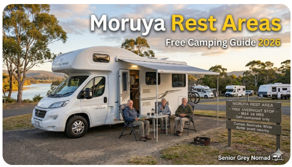
Moruya Rest Area — Free Camping Guide 2026 Senior Grey Nomad
GPS-verified guide to Moruya rest area, Moruya River foreshore overnight parking and free camping options for senior grey nomads on the NSW South Coast Princes Highway — covering facilities, dump points, Moruya District Hospital contacts, Eurobodalla day trips and honest overnight rules for 2026.
📅 Last reviewed: April 2026 | Moruya NSW 2537 | Princes Highway (A1) | Access and overnight rules subject to Eurobodalla Shire Council and NSW Roads signage on arrival
Moruya is a small but genuine river town on the Moruya River, approximately 35 kilometres south of Batemans Bay and 40 kilometres north of Narooma on the Princes Highway. It sits slightly inland from the coast at the tidal reach of the Moruya River — a position that gives it a completely different character from the ocean foreshore towns on either side. For senior grey nomads, Moruya is often overlooked in the rush between Batemans Bay and Narooma, but it deserves better than a fuel-stop glance. The river foreshore is genuinely peaceful, the town has an airport, a hospital, a supermarket and a quiet community character that rewards travellers who stop long enough to find it.
- Location: Moruya, Eurobodalla Shire, NSW South Coast
- State: NSW
- Highway: Princes Highway (A1)
- Use: Day-use foreshore stops; limited overnight options — verify current signage on arrival
- Best for: Quiet river foreshore break, mid-point rest between Batemans Bay and Narooma, hospital checkpoint, resupply
- Toilets: Yes — Moruya River foreshore, Paul’s Beach reserve and town centre
- Dump point: Available in the Moruya area — confirm exact location via Campermate or WikiCamps
- Potable water: Not confirmed at roadside stops — carry your own supply
- Power: No powered sites at public rest areas
- Phone signal: Adequate Telstra in Moruya township; variable on Princes Highway north and south of town
- Nearest town: Moruya NSW 2537
- Nearest major services: Moruya CBD — supermarket, fuel, pharmacy, hospital within the town
Table of Contents
- Location, address and GPS
- Can you stay overnight at Moruya?
- Facilities: toilets, water, bins and dump point
- Nearby public Wi-Fi and mobile coverage
- How to get there
- What to expect on arrival
- Safety for senior grey nomads
- Medical and emergency contacts
- Dump points, water and supplies nearby
- Things to do for seniors in the area
- Best time of year to stop here
- Fires, generators and overnight etiquette
- Packing checklist for seniors
- GPS coordinates and postcodes: save every stop
- Frequently Asked Questions
- Quick verdict
Section 1 — Location, address and GPS
Moruya sits on the southern bank of the Moruya River where the Princes Highway crosses the river on its way south to Narooma. The town centre is compact and built around the highway crossing, with the main street running east from the bridge toward the foreshore park and boat ramp. The Moruya River foreshore is the primary stopping point for grey nomads — a flat, grassed park with picnic facilities, river views and public toilets, accessed via a short detour off the Princes Highway through the town centre. The Princes Highway itself has designated rest areas on the northern and southern approaches that provide basic facilities without the need to navigate the town centre.
Primary GPS Reference — Moruya River Foreshore Park
−35.9058° S, 150.0862° E
Moruya River foreshore park, Church Street, Moruya NSW 2537 — adjacent to the boat ramp and river viewing area
Secondary GPS — Moruya Princes Highway Rest Area (northbound approach): −35.8812° S, 150.0741° E
Secondary GPS — Paul’s Beach Reserve (Moruya Heads, ~8km east): −35.9089° S, 150.1489° E
Secondary GPS — Moruya township centre (services): −35.9065° S, 150.0832° E
| Detail | Information |
|---|---|
| Primary address | Moruya River foreshore, Church Street, Moruya NSW 2537 |
| Highway | Princes Highway (A1) — Moruya is directly on the highway |
| Council | Eurobodalla Shire Council |
| Postcode | 2537 (Moruya, Moruya Heads, Tuross Head, Bodalla) |
| Region | Eurobodalla — NSW South Coast |
| Distance south of Sydney | Approximately 320km via Princes Highway |
| Distance south of Batemans Bay | Approximately 35km via Princes Highway |
| Distance north of Narooma | Approximately 40km via Princes Highway |
| Distance from coast | Approximately 8km from Moruya Heads and ocean beaches |
| Airport | Moruya Airport — approximately 5km northeast of town centre (useful emergency evacuation reference) |
For the complete South Coast corridor GPS directory from Wollongong to Eden, see our Vanlife Savings Spots guide — updated regularly with current overnight rules and facility notes for senior grey nomads.
Section 2 — Can you stay overnight at Moruya?
Moruya is one of the smaller towns on the NSW South Coast corridor and has historically had a degree of informal tolerance for self-contained vehicle overnight stays at the river foreshore — a tolerance that reflects both the town’s relatively light tourist traffic outside school holidays and the practical reality that Moruya serves as a mid-point stop between Batemans Bay and Narooma. The honest current picture as at April 2026 is as follows.
- The Moruya River foreshore park on Church Street is a day-use area managed by Eurobodalla Shire Council — overnight camping is not officially designated at this location. Some self-contained vehicle travellers report using this area for short overnight stops; this is done at the traveller’s own risk and is not a confirmed sanctioned arrangement.
- The Princes Highway rest area north of Moruya (near the Batemans Bay approach) has been used by grey nomads for short overnight stops — verify current NSW Roads signage on arrival as this is subject to change.
- Eurobodalla Shire Council has designated free camping locations within the broader shire — check the Council website and Campermate for current confirmed GPS references before visiting, as these change over time.
- Tuross Head, approximately 20km north of Moruya on a coastal detour, has historically had foreshore camping options — confirm current status via Campermate before planning a stop there.
- A caravan park operates in Moruya — powered and unpowered sites available. Booking is less critical here than at the major coastal tourist towns, but recommended during school holiday periods.
- Narooma, 40km south, has better-developed overnight options for grey nomads — if overnight certainty matters more than the Moruya character, continue to Narooma where options are clearer.
Section 3 — Facilities: toilets, water, bins and dump point
Moruya’s rest area and foreshore facilities are adequate for a daytime stop and reflect the town’s modest size — this is a functional regional town rather than a tourist-polished coastal destination. Facilities are maintained but should not be expected to match the larger stops at Batemans Bay or Narooma on either side.
| Facility | What is available | What seniors should know |
|---|---|---|
| Toilets | Yes — public toilets at the Moruya River foreshore park, town centre near the main street and at the Princes Highway rest area north of town. Paul’s Beach reserve at Moruya Heads also has toilet facilities. | The river foreshore toilets are generally maintained during business hours. The Princes Highway rest area toilets are maintained by NSW Roads and are more reliably available around the clock. Accessible facilities are available at the town centre toilet block — confirm accessible access at the foreshore on arrival. |
| Potable water | Not confirmed at foreshore or highway rest area stops — town centre has tap water points but not all are labelled as potable | Carry a minimum 20-litre sealed drinking water supply. Refill at Moruya supermarket or service station before continuing. Do not use unlabelled park or foreshore taps for drinking, medication preparation or CPAP humidifier water. |
| Dump point | A dump point is available in the Moruya area — confirm exact current location and access hours via Campermate or WikiCamps before visiting | Important checkpoint between Batemans Bay and Narooma. Use the Moruya dump point if your tank is more than half full in either direction — the next confirmed options are at Batemans Bay (35km north) or Narooma (40km south). |
| Showers | No showers at the river foreshore or highway rest areas — Paul’s Beach at Moruya Heads has basic beach change facilities | Beach change facilities are for beach users only. Plan shower access at a caravan park. The Moruya Aquatic Centre may offer public shower access — confirm locally before visiting. |
| Bins | Yes — bins at the river foreshore, town centre and the Princes Highway rest area | Emptied on a regular Council schedule. Less likely to overflow than the larger tourist towns — Moruya’s lower visitor numbers generally mean bins are well-maintained. Take rubbish with you if bins are unexpectedly full. |
| Power | No powered sites at any public rest area or foreshore park | CPAP users must carry a battery pack or inverter for any overnight stop at public rest areas. The Moruya caravan park offers powered sites — contact directly for availability and rates before arriving. |
Section 4 — Nearby public Wi-Fi and mobile coverage
Moruya has adequate mobile coverage for a town of its size on the mid-South Coast, though the coverage quality is noticeably lower than at the larger centres of Batemans Bay to the north and Narooma to the south. The Princes Highway on the approaches to Moruya has variable coverage, and the coastal roads to Moruya Heads and Tuross Head have genuine gaps.
- Telstra: Adequate 4G coverage in Moruya township and the town centre. The Princes Highway north of Moruya toward Batemans Bay has variable coverage through the forested sections. South toward Narooma, coverage is moderate with some gaps through the Bodalla area.
- Optus: Functional in the town centre. Less reliable on the highway approaches and on the coastal detour roads to Moruya Heads and Tuross Head.
- Vodafone/TPG: Limited outside the main town centre — not reliable for navigation or data-heavy tasks in Moruya.
- Free public Wi-Fi: Available at the Moruya Library (Page Street, Moruya) during opening hours — free internet and computer access for seniors managing banking, telehealth appointments or family video calls. One of the most useful free connectivity resources in the town.
- Moruya Library: Open Monday to Friday — a comfortable, air-conditioned space with free Wi-Fi that provides a genuine respite for senior grey nomads needing reliable internet and a comfortable seat after a long drive.
Section 5 — How to get there
Moruya is directly on the Princes Highway, making it straightforward to reach from either direction. The main challenge for grey nomads is that the town centre and river foreshore require a short navigation off the highway through the town’s main street — the foreshore is not directly visible from the highway and some travellers miss it entirely if they are not watching for the turnoff.
From Batemans Bay / Sydney (heading south): Follow the Princes Highway south from Batemans Bay through the Eurobodalla hinterland. The highway crosses the Moruya River bridge and enters the town. Turn left off the Princes Highway at Church Street (immediately after the bridge) to reach the river foreshore park. The Princes Highway rest area is on the right approximately 5km north of the river bridge — useful for a pre-town toilet stop.
From Narooma / South (heading north): Follow the Princes Highway north through Bodalla and the coastal hinterland. Enter Moruya from the south on the Princes Highway. Turn right onto Church Street just before the river bridge to reach the foreshore car park. The town centre is immediately accessible from this point.
Driving notes for seniors towing vans
- The Moruya River bridge on the Princes Highway has a standard two-lane configuration — manageable for caravans and motorhomes but requires attention to oncoming traffic widths on the bridge deck
- Church Street from the Princes Highway to the foreshore is a standard suburban street — manageable for most rigs but the foreshore car park has a limited turning area; assess before committing with a large rig
- The Princes Highway through Moruya town has pedestrian crossings and school zone speed restrictions near the school on the southern approach — slow down through the entire town section
- The section of Princes Highway between Batemans Bay and Moruya passes through forested coastal hinterland with limited shoulders — maintain safe following distance and do not attempt to overtake in poor visibility sections
- Bodalla, approximately 15km south of Moruya, is a small village on the highway with a sharp bend through the main street — approach at reduced speed, particularly with a long rig
- Fuel in Moruya is available from service stations on the Princes Highway through town — prices are generally moderate and represent a reasonable fill-up opportunity between Batemans Bay and Narooma
Section 6 — What to expect on arrival
Moruya has a character that genuinely surprises many grey nomads who have been conditioned by the coastal tourist towns on either side. It is a working river town — not a beach holiday destination. The main street has the feel of a genuine regional community: a hardware store, a bakery, a pub, a school, a hospital and a supermarket. The river foreshore is quiet and functional rather than manicured and tourist-polished, and on a weekday morning you are likely to share it with dog walkers, retirees from the town and the occasional fishing boat. This is exactly the kind of stop that many senior grey nomads say they have been looking for.
- The river foreshore is grassed and flat with picnic tables, river views and a boat ramp — it is genuinely pleasant without being spectacular; the appeal is in the quiet and the authenticity rather than dramatic scenery
- The town centre is within a five-minute walk from the foreshore — flat and accessible for most senior mobility levels
- Moruya market (held on the second Sunday of each month at the showground) is one of the South Coast’s most genuine community markets — worth timing your visit if you can
- The Princes Highway rest area north of town is a cleaner, simpler option if you want a quick toilet stop and leg stretch without navigating the town centre
- Moruya Heads, approximately 8km east on a coastal road, provides ocean beach access — the road to Moruya Heads is manageable for most vehicles but check suitability for your rig before attempting it with a large caravan
Section 7 — Safety for senior grey nomads
Personal safety
- Moruya is a generally safe, quiet regional town for senior grey nomads — the community character is local and family-oriented with very limited tourist-related antisocial behaviour
- The river foreshore car park is more isolated than a town centre car park — solo senior travellers should park in the most visible section near the boat ramp and foreshore picnic area rather than at the back of the park near the river vegetation
- The foreshore at night is unlit in most sections — do not walk the foreshore path after dark without a torch, and be aware of the uneven ground near the boat ramp area
- Do not leave valuables visible in your vehicle at the foreshore car park — while theft risk is low in Moruya compared to larger tourist towns, opportunistic incidents do occur at boat ramp car parks on the South Coast
- Check in with a family member or emergency contact when you arrive in Moruya — the section between Batemans Bay and Narooma has coverage gaps and letting someone know you have arrived safely is good practice
Trip safety
- Before departing Moruya heading south, check NSW Live Traffic for any incidents on the Princes Highway between Moruya and Narooma — the highway through Bodalla and the coastal approach to Narooma has had periodic rockfall events and single-lane stoppages
- Kangaroo activity on the Princes Highway through the Eurobodalla hinterland between Moruya and Narooma is significant at dusk and dawn — plan your driving to arrive at Narooma before dusk if possible
- Moruya District Hospital is an MPS facility — it provides emergency care but complex cases require transfer to Batemans Bay Hospital or Canberra. Know this before you need it and carry your full medical history summary in an accessible location in your vehicle.
- Moruya Airport (approximately 5km northeast) provides a reference point for emergency helicopter access if needed — this is worth knowing for senior travellers with significant health considerations
For guidance on protecting your van from theft at river foreshore and boat ramp car parks — one of the most overlooked theft risk environments on the east coast — see our guide on how caravan theft happens in Australia.
Section 8 — Medical and emergency contacts
| Service | Address | GPS | Phone |
|---|---|---|---|
| Moruya District Hospital (MPS ED) | Ford Street, Moruya NSW 2537 | −35.9065° S, 150.0832° E | (02) 4474 0444 |
| Batemans Bay Hospital (Full ED) | Bass Avenue, Batemans Bay NSW 2536 | −35.7052° S, 150.1682° E | (02) 4493 2155 |
| Emergency (Police/Fire/Ambulance) | All locations | — | 000 |
| Healthdirect (nurse on call 24hr) | Phone service only | — | 1800 022 222 |
| NSW Police — Moruya | 5 Church Street, Moruya NSW 2537 | −35.9065° S, 150.0842° E | (02) 4474 1599 |
Section 9 — Dump points, water and supplies nearby
There is no dump point at the Moruya River foreshore park or at the main Princes Highway rest area. However, a dump point is available in the Moruya area and represents an important checkpoint between the Batemans Bay and Narooma options on either side. Moruya’s supermarket and fuel station also provide a useful mid-corridor resupply opportunity that many grey nomads underutilise.
| Need | Best nearby option | Notes |
|---|---|---|
| Dump point | Moruya area dump point — confirm exact current location and access hours via Campermate or WikiCamps before visiting | Use the Moruya dump point if your tank is more than half full — the distance to the next confirmed options at Batemans Bay (35km north) or Narooma (40km south) makes Moruya the logical mid-point service. Do not assume the dump point location has not changed — confirm via app before visiting. |
| Fresh water | Moruya IGA supermarket or ALDI on the Princes Highway; service stations through town | Purchase sealed water containers from the supermarket. Do not use the river foreshore taps for drinking water — the Moruya River is tidal and river water is not suitable for consumption. Carry a minimum 20-litre sealed supply. |
| Groceries and fuel | ALDI Moruya (Princes Highway); IGA Moruya (town centre); multiple service stations on Princes Highway through town | Moruya’s ALDI is a genuinely useful grocery stop — good range at competitive prices. Fuel prices are moderate. This is a worthwhile resupply stop even if Batemans Bay was your last stop — topping up here before Narooma is good practice. |
| Major supplies (pharmacy, LPG, hardware) | Moruya pharmacy (town centre); LPG cylinder exchange at service stations; limited hardware at IGA or town centre stores | Pharmacy in Moruya has reasonable but limited stock compared to Batemans Bay. Fill LPG here if needed — the next reliable option is Narooma. For major hardware or caravan supplies, Batemans Bay is a better option. |
| Alternative nearby stop | Tuross Head NSW 2537 (~20km north via coastal road) — foreshore village with basic facilities; Bodalla NSW 2545 (~15km south) — tiny highway village with fuel and limited supplies | Tuross Head is worth a coastal detour if you have time and your rig size suits the access roads. Bodalla is a historic dairy village — worth a brief stop for the historic buildings but has very limited services for grey nomads. |
For a full guide to planning caravan park stays around free rest area stops along the South Coast corridor, see our guide on how long you can stay in a caravan park in Australia.
Section 10 — Things to do for seniors in the area
Moruya and the surrounding Eurobodalla area offer a surprising range of experiences for senior grey nomads who take the time to look beyond the highway. The river, the coast, the historic town and the broader Eurobodalla hinterland all reward exploration at a pace that suits senior travellers.
| Activity | Location | Why seniors like it |
|---|---|---|
| Moruya River Foreshore Walk | Church Street foreshore, Moruya NSW 2537 | Flat, easy river foreshore path — accessible for most mobility levels, quiet and genuinely peaceful on weekday mornings, good birdwatching along the river margins, picnic tables and toilets adjacent |
| Moruya Markets | Moruya Showground, Moruya NSW 2537 — second Sunday of each month | One of the South Coast’s most genuine community markets — local produce, crafts, hot food and a strong community character; flat venue, easy parking, excellent for social connection for solo grey nomad travellers |
| Moruya Heads and Bar Beach | Moruya Heads NSW 2537 (~8km east via Moruya Heads Road) | Wild ocean beach with a bar entrance — excellent for those who want an uncrowded ocean experience without the tourist density of Batemans Bay or Narooma; accessible beach path from the car park |
| Bodalla Heritage Drive | Princes Highway through Bodalla NSW 2545 (~15km south) | Historic 19th-century dairy estate village with heritage stone buildings and a famous cheese factory history — a brief but genuinely interesting stop on the highway between Moruya and Narooma |
| Tuross Head Foreshore | Tuross Head NSW 2537 (~20km north via coastal road) | Quiet coastal village on the Tuross River estuary — flat foreshore walks, good birdwatching, oyster leases and a very low-tourist-density environment that suits senior grey nomads seeking peace over spectacle |
Best senior-friendly ideas at Moruya
- Arrive early at the river foreshore and walk the flat path along the river in the morning light — the birdlife along the Moruya River at dawn is exceptional and the peaceful atmosphere is a genuine contrast to the busier highway towns
- If your visit coincides with the second Sunday of the month, the Moruya Markets are absolutely worth attending — buy local produce, support community stallholders and have a proper conversation with South Coast locals rather than other grey nomads
- Drive the 8km to Moruya Heads for a morning ocean walk — the beach is uncrowded, the bar entrance is dramatic and the whole experience feels like a secret that the highway bypasses entirely
- Stop at the Moruya bakery on the main street for a genuine small-town bakery experience — this is the kind of stop that grey nomad travel exists to deliver and that most travel sites forget to mention
- Use the Moruya Library for an hour if you need connectivity — the quiet, air-conditioned environment and free Wi-Fi make it one of the better practical rest stops in any small town on the South Coast
For an honest and detailed account of what extended grey nomad van life looks like across months on the road — including the quieter days like Moruya that become the ones you remember most — read our guide on living in a camper.
Section 11 — Best time of year to stop here
| Season | What it is like | Senior verdict |
|---|---|---|
| Summer (Dec–Feb) | Hot and humid (23–30°C), school holiday visitors increase but Moruya is less affected by tourist crowds than the ocean beach towns. River foreshore stays relatively accessible. Summer storms and heavy rain can cause river flooding — monitor conditions carefully. January can bring higher traffic volumes on the Princes Highway through town. | Manageable — Moruya’s inland river position makes it less overwhelmed by school holiday crowds than Batemans Bay or Narooma. However, summer heat at the river foreshore without shade can be uncomfortable for senior travellers in the middle of the day. Arrive early or after 4pm. Be aware of flood risk during heavy summer rain events. |
| Autumn (Mar–May) | Excellent conditions — warm days (17–24°C), low humidity, stable weather, very few tourists. The Moruya River at its most placid and beautiful. Markets are well-attended without being crowded. The surrounding hinterland shows autumn colour changes in the introduced deciduous trees in the town. | Highly recommended — Moruya in autumn is the South Coast at its most unhurried. March through May is ideal for a genuine small-town rest day. The river foreshore in early morning autumn light with low mist on the water is one of those quiet travel moments that grey nomads describe as the reason they chose this life. |
| Winter (Jun–Aug) | Mild coastal winters (9–17°C), occasional cold fronts and heavy rain, river can rise significantly after sustained rainfall. Very few tourists. Town retains its community character without any holiday overlay. | Good for experienced grey nomads comfortable with cool conditions. Winter overnight temperatures can approach single digits at Moruya which is slightly inland — ensure adequate van heating or warm sleeping equipment. River flood awareness is important in winter when persistent cold fronts deliver sustained rainfall. The town market in winter is a warm and friendly community experience. |
| Spring (Sep–Nov) | Warming temperatures (14–23°C), wildflowers on surrounding hinterland and coastal heath, whale watching begins on the return migration. Tourist numbers build from mid-October but Moruya remains considerably quieter than the coastal towns. Occasional spring storm systems. | Excellent overall — September and October are very good months for Moruya. The surrounding countryside greens up beautifully, the markets have a spring energy and the drive between Batemans Bay and Moruya through the Eurobodalla hinterland is particularly scenic in spring light. The second-Sunday market in October is one of the year’s best. |
Section 12 — Fires, generators and overnight etiquette
Moruya’s public foreshore and rest areas are managed by Eurobodalla Shire Council under the same regulations that apply across the shire. The rules regarding fires and generators are consistent with the broader South Coast pattern and are taken seriously — particularly given the river environment and the proximity of residential areas to the foreshore park.
- Open fires of any kind are prohibited at the Moruya River foreshore park, the town centre parks and all Eurobodalla Shire Council managed public areas — no campfires, no fire pits, no burning of material of any kind
- Portable gas stoves used for cooking in picnic areas during daylight hours are generally tolerated — use them at the designated picnic tables and not in the car park itself
- Generators are not appropriate at the river foreshore — the foreshore park sits adjacent to residential properties and the sound of a running generator will generate complaints from nearby residents very quickly
- If an overnight stop is occurring at the foreshore (having verified current signage on arrival), maintain a minimal footprint — do not extend awnings or set up chairs and tables in the car park itself; this is a shared public space used by locals daily
- All wastewater must be retained in your vehicle and disposed of at the designated dump point — the Moruya River is an estuary supporting oyster aquaculture downstream; any wastewater discharge near the river or in the car park is both illegal and directly harmful to the local marine environment and fishing industry
- Dogs are welcome at the foreshore park — check current Eurobodalla Shire Council signage for on-leash requirements at this specific location before allowing your dog off lead
Section 13 — Packing checklist for seniors stopping at Moruya
| Item | Why it matters at Moruya | ☐ |
|---|---|---|
| Sealed drinking water (min 20L) | No confirmed potable water at rest stops — the Moruya River is not drinkable; refill at Moruya supermarket | ☐ |
| Medication supply (7+ days) | Moruya pharmacy has limited stock compared to Batemans Bay — fill repeats at Batemans Bay before arriving | ☐ |
| CPAP battery pack or inverter | No powered sites at public rest areas — battery essential for any overnight stop at foreshore or rest area | ☐ |
| Offline maps (Moruya to Narooma and Bermagui) | Download maps in Moruya while Telstra 4G is available — coverage becomes less reliable south of Narooma | ☐ |
| Bureau of Meteorology app checked | River flood risk at the foreshore makes weather monitoring essential before overnight stops — check BOM and NSW SES flood warnings for Eurobodalla | ☐ |
| Full fuel tank | Fuel in Moruya is available at moderate prices — fill up here; the next comparable fuel stop is Narooma (40km south) | ☐ |
| Dump station completed | Use the Moruya dump point if your tank is more than half full — it is the logical checkpoint between Batemans Bay and Narooma | ☐ |
| Torch and non-slip footwear | River foreshore paths are unlit and uneven near the boat ramp area after dark — a torch and good footwear prevent trips and falls | ☐ |
| Insect repellent | The Moruya River foreshore has significant mosquito activity, particularly at dusk in warmer months — the tidal estuary environment supports large mosquito populations | ☐ |
| Vehicle security device active | Boat ramp car parks carry a low but real theft risk — ensure immobiliser is active and valuables are not visible when leaving the vehicle | ☐ |
COPY PROMPT ➔ ASK AI ➔ SAVE TO FORM ➔ ADD SPOT PIN ➔ GET DIRECTIONS
📍 Interactive map — find free camps, rest areas and overnight stops near Moruya. Enable location for best results.
Section 14 — GPS coordinates and postcodes: save every stop
Save all of these coordinates before leaving Moruya heading south. The section from Moruya to Narooma involves 40km of coastal hinterland highway with limited services and variable mobile coverage. Knowing your next hospital, dump point and fuel stop in advance reduces driving anxiety on this section. For the full South Coast GPS corridor directory, see our Vanlife Savings Spots guide.
| Location | Address + Postcode | GPS | Notes |
|---|---|---|---|
| Moruya River Foreshore Park | Church Street, Moruya NSW 2537 | −35.9058° S, 150.0862° E | Primary rest stop — day use confirmed; overnight rules subject to current Eurobodalla Shire Council signage. River flood risk — check BOM before overnight stays. |
| Moruya township (nearest services) | Princes Highway, Moruya NSW 2537 | −35.9065° S, 150.0832° E | ALDI, IGA, pharmacies, fuel, LPG. Adequate mid-corridor resupply — not as comprehensive as Batemans Bay. |
| Moruya District Hospital (MPS ED) | Ford Street, Moruya NSW 2537 | −35.9065° S, 150.0832° E | MPS hospital — 24-hour emergency care. Phone: (02) 4474 0444. Complex cases transferred to Batemans Bay (35km north) or Canberra. |
| Batemans Bay Hospital (Full ED) | Bass Avenue, Batemans Bay NSW 2536 | −35.7052° S, 150.1682° E | Full district hospital — approximately 35km north. Phone: (02) 4493 2155. Nearest full ED north of Moruya. |
| Narooma (nearest major town south) | Princes Highway, Narooma NSW 2546 | −36.2175° S, 150.1339° E | Approximately 40km south — next significant service town with supermarket, hospital MPS and caravan options. |
Section 15 — Frequently Asked Questions
Is Moruya rest area free to camp at?
There are no officially designated free camping sites within the Moruya urban area confirmed as of April 2026. The Moruya River foreshore park is a day-use area managed by Eurobodalla Shire Council — overnight camping is not officially designated. Some self-contained vehicle travellers use the foreshore for short overnight stops and there has been a degree of informal tolerance historically, but this cannot be relied upon and is subject to change. Always verify current signage at the foreshore park on arrival before staying overnight. Eurobodalla Shire Council has designated free camping locations within the broader shire — check the Council website and Campermate for current confirmed GPS references.
Can caravans and motorhomes stay overnight at Moruya?
Self-contained vehicles can stop at the Moruya River foreshore and the Princes Highway rest area during the day without restriction. For overnight stays, the river foreshore signage must be checked on arrival — if overnight permission is not explicitly stated in current signage, do not assume it is permitted. A caravan park operates in Moruya and offers powered and unpowered sites. The Princes Highway rest area north of Moruya has been used by grey nomads for short overnight stops — verify current NSW Roads signage at the site on arrival.
What is the GPS for Moruya rest area?
The Moruya River foreshore park is at −35.9058° S, 150.0862° E (Church Street, Moruya NSW 2537). The Princes Highway rest area north of Moruya is at approximately −35.8812° S, 150.0741° E. Paul’s Beach reserve at Moruya Heads is at approximately −35.9089° S, 150.1489° E. Always confirm coordinates against current signage on arrival — the foreshore has multiple access points and GPS devices can direct you to different entry routes depending on mapping software.
Are there toilets at Moruya rest area?
Yes. Public toilets are available at the Moruya River foreshore park, the town centre and the Princes Highway rest area north of town. The Princes Highway rest area toilets are maintained by NSW Roads and are the most reliably available option around the clock. The foreshore toilets are generally maintained during business hours. An accessible toilet block is available in the Moruya town centre — confirm accessible access at the foreshore on arrival if this is a specific requirement.
Is there a dump point at Moruya?
A dump point is available in the Moruya area. The exact current location and access hours should be confirmed via Campermate or WikiCamps before visiting, as access can change without notice. Using the Moruya dump point is recommended if your holding tank is more than half full — the distance to the next confirmed options at Batemans Bay (35km north) or Narooma (40km south) makes Moruya the logical mid-point checkpoint for travellers on this section of the corridor.
Can you get potable water at Moruya rest area?
Potable water is not confirmed at the Moruya River foreshore or highway rest areas. The Moruya River is a tidal estuary — its water is not suitable for consumption at any point. Carry a minimum 20-litre sealed drinking water supply and refill from Moruya’s ALDI or IGA supermarket or a service station. Do not use unlabelled park taps for drinking, medication preparation or CPAP humidifier water.
Is Moruya safe for solo senior travellers?
Moruya is a generally safe, quiet regional community for solo senior grey nomads. The town has a genuine local character with very little tourist-related antisocial behaviour. Normal precautions apply at the river foreshore after dark — the area is unlit in most sections and the ground near the boat ramp is uneven. Park in the most visible section of the foreshore and use a torch when walking after dark. Inform a family member or emergency contact of your overnight location. The proximity of the town centre and the police station provides a degree of reassurance for solo travellers.
What is the nearest hospital to Moruya?
Moruya District Hospital on Ford Street, Moruya NSW 2537 (GPS: −35.9065° S, 150.0832° E, phone: (02) 4474 0444) is the nearest facility — an MPS hospital with 24-hour emergency care approximately 500 metres from the town centre. For complex specialist care, transfer to Batemans Bay Hospital (approximately 35km north, phone: (02) 4493 2155) or Canberra Base Hospital is required. The nearest hospital south is Narooma MPS (approximately 40km, phone: (02) 4476 2811). Call 000 for all life-threatening emergencies.
Is the Moruya River foreshore flood-prone?
Yes — this is an important consideration for overnight stops. The Moruya River foreshore park sits at low elevation adjacent to a river that has a history of flooding during and after significant rainfall events. The Moruya catchment can respond quickly to heavy rain, particularly in summer and winter wet season events. Before planning an overnight stay at the river foreshore, check the Bureau of Meteorology forecast for the Eurobodalla region and the NSW SES Moruya River flood warnings. If significant rainfall is forecast or flood warnings are active, choose a higher-elevation overnight stop — the Princes Highway rest area north of Moruya sits at higher ground and is a safer alternative in wet weather.
Section 16 — Quick verdict
Moruya is the quiet achiever of the NSW South Coast grey nomad corridor — a small river town that most travellers slide through on the highway without fully realising what they are passing. The river foreshore, the community markets, the genuine small-town bakery and pub, the birdlife on the river margins and the uncrowded walk to Moruya Heads all reward the traveller who gives Moruya more than a fuel stop’s worth of attention. For senior grey nomads who have been moving steadily since Wollongong, Moruya has a pace and a quietness that is genuinely therapeutic — the kind of stop where you park up, pour a cup of tea at the river foreshore, and realise you feel more rested after an hour here than after a busy night at a crowded holiday park.
The honest constraints are real and should be acknowledged clearly. Moruya is a small town with limited services — its supermarket, pharmacy and hospital are adequate but not comprehensive, and major specialist needs require a 35-kilometre trip to Batemans Bay. The MPS hospital’s transfer dependency for complex cases is a genuine planning consideration for senior travellers with significant health histories. The river flood risk at the foreshore requires monitoring in wet weather and is not something that should be dismissed as unlikely — Moruya floods with relative regularity. And the overnight parking situation requires genuine on-arrival signage verification rather than assumed tolerance. But none of these constraints diminish the town’s value on the corridor — they simply require honest advance planning. Moruya rewards the prepared, patient and unhurried grey nomad more consistently than almost anywhere on this route.
- Batemans Bay Rest Areas — approximately 35km north, full district hospital, Clyde River oysters, comprehensive resupply
- Ulladulla Rest Areas — approximately 85km north, harbour foreshore, Murramarang NP, dump point checkpoint
- Narooma Rest Areas — approximately 40km south, one of the most scenic towns on the entire corridor
- Nowra Rest Areas — approximately 150km north, last major service town before the South Coast corridor
- NSW South Coast Free Camping Hub — complete corridor guide from Wollongong to Eden
- Rest Areas NSW — statewide directory with GPS coordinates and overnight rules
- Free Camping NSW — comprehensive statewide guide for senior grey nomads
Free campsites and powered sites fill fast during school holidays and peak season. If your preferred site is already gone, search remaining accommodation options below to explore the region.
Accommodation and flight search powered by Expedia. Booking through this search supports this website at no extra cost to you. As an affiliate, I earn from qualifying purchases at no extra cost to you.

As an affiliate, I earn from qualifying purchases at no extra cost to you.
Exclusive Offer: Get 5% OFF all StarterStopper immobiliser products with promo code: RTV5
Visit StarterStopper.com to see our data-backed security solutions
As an affiliate, I earn from qualifying purchases at no extra cost to you.