Lyndon River Rest Area — The Complete 2026 Senior Grey Nomad Guide to Free Camping on the North West Coastal Highway Between Carnarvon and Exmouth
| Cost | Free — no permit, no fee, no registration |
| GPS | -23.4667, 114.1180 (verify before departure — see note) |
| Highway | North West Coastal Highway (National Highway 1), WA |
| Stay Limit | 24 hours maximum |
| Managed By | Main Roads Western Australia |
| Toilets | ❌ None — must be fully self-contained |
| Water | ❌ None — fill completely in Carnarvon |
| Power | ❌ None — solar/lithium setups required for CPAP |
| Phone Signal | ❌ Nil (all carriers) — PLB or satellite communicator essential |
| Dogs | ✅ On lead — snake aware at all times |
| Best Season | May–September (avoid Oct–Apr: heat, cyclones, flooding) |
| Nearest Hospital South | Carnarvon ~140 km — 08 9941 0555 |
| Nearest Hospital North | Exmouth ~230 km — 08 9949 1011 |
| Senior Verdict | ⚠️ Drive-break only. Self-contained experienced travellers. One night max. |
- 1. Why Grey Nomads Stop at Lyndon River Rest Area
- 2. How to Get There — Directions and Access
- 3. What to Expect on Arrival
- 4. Facilities Table — Quick Facts 2026
- 5. Dump Point, Water and Fuel — GPS Table
- 6. Fires, Generators and Noise Rules
- 7. Monthly Weather and Best Time to Visit
- 8. Wildlife and Birdlife
- 9. Stargazing at Lyndon River
- 10. History of the Lyndon River and North West Coastal Highway
- 11. Accessibility for Senior Travellers
- 12. Safety and Emergency Plan — Hospitals, Police, RFDS
- 13. CPAP and Medical Power at Lyndon River
- 14. Road Conditions — North West Coastal Highway
- 15. Cooking and Meal Ideas for One Night Off-Grid
- 16. Waste Management and Leave No Trace
- 17. Rest Area Etiquette
- 18. Van Life Savings Spots — Free Camping Nearby
- 19. Nearby Attractions — Coral Bay, Exmouth and Ningaloo Reef
- 20. Comparison vs Other Locations on This Corridor
- 21. Senior Packing Checklist for Lyndon River Rest Area
- 22. Grey Nomad Reviews and Traveller Notes
- 23. GPS Master Table — Save Every Stop Before You Lose Signal
- 24. Frequently Asked Questions — Minimum 15 Questions
- 25. Quick-Reference Card and Final Verdict
- 26. Disclaimer
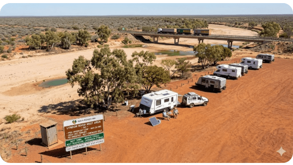
Lyndon River Rest Area is a free, gazetted Main Roads Western Australia rest stop on the North West Coastal Highway, positioned where the sealed highway crosses the Lyndon River in the Shire of Carnarvon. For senior grey nomads heading north toward Ningaloo Reef in 2026, it occupies a precise and critical function: breaking the brutally long, service-free drive between Carnarvon and the Minilya–Exmouth Road junction into two safe, manageable legs. It sits approximately 140 km north of Carnarvon and roughly 70 km south of the Minilya–Exmouth Road junction — the decision point for travellers heading either to Coral Bay or Exmouth. There is nothing glamorous about this rest area. It has no toilets, no water, no power, no bins, no phone signal, and no shade structures. What it has is a flat gravel surface, an extraordinary night sky, and the simple, irreplaceable gift of a safe place to sleep before continuing one of Australia’s most demanding remote highway drives. This guide gives you every fact, every GPS coordinate, every safety consideration, and every planning detail you need to use Lyndon River Rest Area well — as part of one of the classic grey nomad routes around Australia.
1. Why Grey Nomads Stop at Lyndon River Rest Area
The arithmetic of this corridor is the reason Lyndon River Rest Area exists. Carnarvon to Exmouth is approximately 370 km of remote, sparsely serviced highway — the North West Coastal Highway swinging north through red earth and spinifex, then hooking onto the Minilya–Exmouth Road for the final approach to the coast. For a senior grey nomad who left Carnarvon at 7 AM and is towing a 21-foot van in 36-degree heat, 370 km in a single session is an invitation to fatigue, poor decision-making, and genuine medical risk.
The Lyndon River Rest Area solves this problem. At approximately 140 km north of Carnarvon, it arrives at precisely the right moment — after a sensible morning’s drive, before the heat peaks, before driver fatigue sets in. You stop. You sleep. The next morning you drive a fresh 230 km to Exmouth or 220 km to Coral Bay, arriving before midday, in controlled conditions, with a clear head. That two-day strategy is how experienced grey nomads travel this corridor. This rest area is the pivot point that makes it possible.
Between May and September — the peak grey nomad travel season in WA — the Lyndon River Rest Area becomes a social hub of sorts. Five to twenty rigs parked up each evening, campfires lit (conditions permitting), the kind of informal outback conversation that retired travellers remember for years. Couples sharing cold beers after a hot drive, comparing notes on Coral Bay bookings, recommending mechanics in Exmouth. This communal aspect is part of what makes van life in retirement so rich — and why living in a camper during retirement draws so many Australians to the road each year.
The other reason grey nomads stop here is simpler: there is nowhere else. Between Carnarvon and Minilya Roadhouse (which may or may not be operating), the highway offers no alternative safe overnight stop, no fuel, no water, no services of any kind. The Lyndon River Rest Area is not just convenient — for many travellers, it is the only viable option.
2. How to Get There — Directions and Access
The Lyndon River Rest Area is straightforward to reach — it sits directly on the sealed North West Coastal Highway (National Highway 1) and requires no detour, no dirt road, and no special vehicle access. There is only one road: head north from Carnarvon on the North West Coastal Highway and drive approximately 140 km. The rest area will appear on the left (western) side of the road at the Lyndon River bridge crossing.
From Carnarvon (Northbound — Most Common Approach)
Depart Carnarvon heading north on the North West Coastal Highway. The sealed highway is well maintained for this section in most conditions. At approximately 140 km, you will reach the Lyndon River bridge crossing. The rest area pullover is visible from the road — a cleared gravel area adjacent to the river channel. There is no formal sign-in or gate. Simply pull off the highway, choose your spot on the flat gravel area, and park clear of the roadway.
From Minilya Junction (Southbound)
If approaching from the north — returning from Exmouth or Coral Bay — the Lyndon River Rest Area is approximately 70 km south of the Minilya–Exmouth Road junction on the right (eastern) side. It arrives approximately 5 km after Minilya Roadhouse if travelling south.
Key Distances Table
| Destination | Direction | Distance | GPS |
|---|---|---|---|
| Carnarvon town centre | South | ~140 km | -24.8833, 113.6594 |
| Minilya Roadhouse | North | ~65 km | -23.3920, 114.0130 |
| Minilya–Exmouth Road junction | North | ~70 km | -23.3920, 114.0130 |
| Coral Bay | North-west | ~220 km total | -23.1520, 113.7670 |
| Exmouth | North | ~230 km total | -21.9350, 114.1240 |
| Minilya River Rest Area | North | ~30 km | -23.4850, 114.1060 |
3. What to Expect on Arrival at Lyndon River Rest Area
Setting realistic expectations before arrival at a remote rest area is the mark of an experienced grey nomad. Lyndon River will not surprise you if you have read this guide. Here is exactly what you will encounter when you pull off the highway.
The Approach
The rest area becomes visible from the highway approximately 200–300 metres before the river crossing. You will see a widened gravel verge or cleared flat area adjacent to the road. There is no formal entry gate or boom barrier. During peak season, you will likely see other caravans and motorhomes already parked when you arrive. During off-peak, you may be completely alone. The rest area is on flat, mostly open ground — reddish-brown compacted earth and gravel beside the typically dry Lyndon River channel.
The Parking Surface
The surface is compacted gravel and earth, generally flat and suitable for large rigs — A-class motorhomes, fifth-wheelers, and triple-axle caravans have all used this stop without difficulty. After heavy rain (typically during cyclone season, November–April), sections of the rest area can become soft. If you are travelling outside the recommended May–September window and there has been recent rainfall in the Gascoyne catchment, approach with caution and do not drive onto any section that looks damp or soft.
Shade and Shelter
Shade availability at Lyndon River depends entirely on recent conditions. Scattered river gum and acacia trees along the Lyndon River channel may provide partial afternoon shade in good years. After drought or flood cycles, these trees may be sparse or absent. Do not rely on natural shade — bring your own awning, shade sail, or annex. In the recommended May–September travel season, the sun angle is lower and shade becomes less critical, but even in winter the midday sun on this arid highway is strong.
Noise Environment
The North West Coastal Highway is a major freight corridor. Triple-road-train combinations — the 53-metre giants of the WA outback — run between the Pilbara mining regions and Carnarvon through the night. Their passage is unmistakable: engine roar, compressed air brakes, the deep thrum of eighteen or more tyres on sealed highway at 100 km/h. This noise is unavoidable at Lyndon River. It is not constant — road trains pass every 30–90 minutes depending on the time of year and day — but each passage is loud and jarring for light sleepers. Earplugs are not a luxury at this rest area; they are essential kit.
The River
For most of the year, the Lyndon River is a dry, sandy channel. If you arrive during or after significant rainfall in the Gascoyne catchment, it may be flowing. A flowing Lyndon River is a warning sign — not an attraction. Flash flooding in this catchment can raise river levels rapidly and the highway crossing can become impassable. Never camp at the bottom of the river channel or in low-lying areas near the bank. Always park on higher, firm ground above the riverbed level.
4. Facilities Table — Quick Facts 2026
| Facility | Status | Senior Notes |
|---|---|---|
| Toilets | ❌ None | Onboard toilet mandatory. Self-contained is non-negotiable. |
| Showers | ❌ None | Onboard shower or body wipe only. |
| Potable Water | ❌ None | River is almost always dry and not potable when flowing. Fill completely in Carnarvon. |
| 240V Power | ❌ None | Solar and lithium battery essential for CPAP users. |
| Dump Point | ❌ None | Nearest: Carnarvon ~140 km south. Use before heading north. |
| Bins / Rubbish | ❌ None | Pack all rubbish out. Leave no trace. |
| Fuel | ❌ None | Nearest: Minilya Roadhouse ~65 km north (verify open). Fill completely in Carnarvon. |
| Phone Signal | ❌ Nil all carriers | Telstra nil to extremely weak. Optus nil. Vodafone nil. PLB or satellite communicator essential. |
| WiFi | ❌ None | Zero connectivity of any kind. Download everything in Carnarvon. |
| Shade Structures | ⚠️ Minimal | Scattered native trees along dry riverbed may provide partial shade. Do not rely on it. |
| Ground Surface | ✅ Flat, firm gravel | Compacted earth and gravel. Generally level. Suitable for large rigs, fifth-wheelers, A-class motorhomes. |
| Big Rig Access | ✅ Yes | Direct sealed highway access. No corrugated tracks or soft sand. |
| Dogs | ✅ Yes — on lead | On lead at all times. Snakes active Oct–Mar. Check under van before packing up. Note: dogs not permitted in Cape Range NP. |
| Cost | ✅ Free | No permit, no parks pass, no shire fee. Main Roads WA gazetted rest stop. |
| Stay Limit | 24 hours max | One night. This is a drive-break, not a destination. |
| Nearby Public WiFi | ❌ None within 65 km | Nearest WiFi: Carnarvon Library, Carnarvon, WA 6701. GPS: -24.8833, 113.6594. Use before departure. |
5. Dump Point, Water and Fuel — GPS Table for the Full Corridor
The three most critical logistics for self-contained grey nomads on this corridor are dump points, water top-ups, and fuel. Lyndon River Rest Area has none of the three. Plan every service stop before you depart Carnarvon — this is your last fully serviced town until Coral Bay or Exmouth, more than 200 km away.
Dump Points
| 🗑️ Dump Point | Location | GPS | GPS Source | Dist. from Lyndon River | Notes |
|---|---|---|---|---|---|
| Carnarvon (BEFORE) | Fascine / Babbage Island Rd area, Carnarvon WA 6701 | -24.8970, 113.6620 | WikiCamps AU / publicly available | ~140 km south | Free. 24-hour access. Empty before heading north. Mandatory. |
| Lyndon River (ON-SITE) | North West Coastal Hwy at river crossing | -23.4667, 114.1180 | — | — | ❌ No dump point on-site. |
| Coral Bay (AFTER) | Near caravan parks, Coral Bay WA 6701 | -23.1520, 113.7670 | WikiCamps AU / publicly available | ~220 km north-west | Free. Verify location with caravan park on arrival. Check signage. |
| Exmouth (AFTER) | Murat Road area, Exmouth WA 6707 | -21.9350, 114.1240 | WikiCamps AU / publicly available | ~230 km north | Free. 24-hour access. Well signed in town. |
Water Top-Up Points
| 💧 Water Point | Location | GPS | Distance | Notes |
|---|---|---|---|---|
| Carnarvon | Multiple sources, Carnarvon WA 6701 | -24.8833, 113.6594 | ~140 km south | Last reliable water. Fill to absolute maximum capacity. Caravan parks, fuel stations, visitor centre. |
| Lyndon River | On-site | -23.4667, 114.1180 | — | ❌ No potable water. River usually dry and not safe when flowing. |
| Minilya Roadhouse | North West Coastal Hwy, WA | -23.3920, 114.0130 | ~65 km north | ⚠️ If operational. Do not rely on this. Premium prices. Verify before travel. |
| Coral Bay | Coral Bay WA 6701 | -23.1520, 113.7670 | ~220 km NW | ✅ Available at caravan parks for guests. |
| Exmouth | Exmouth WA 6707 | -21.9350, 114.1240 | ~230 km north | ✅ Multiple sources — caravan parks, public taps, fuel stations. |
Fuel Stations
| ⛽ Fuel Stop | Location | GPS | Distance | Notes |
|---|---|---|---|---|
| Carnarvon (multiple) | Carnarvon WA 6701 | -24.8833, 113.6594 | ~140 km south | Fill completely here. Cheapest fuel on this corridor. Multiple outlets including Caltex and independents. |
| Minilya Roadhouse | North West Coastal Hwy, WA | -23.3920, 114.0130 | ~65 km north | ⚠️ Verify operational before travel. Premium prices when open. Has experienced closures. |
| Coral Bay | Coral Bay WA 6701 | -23.1520, 113.7670 | ~220 km NW | ✅ Available. Remote premium pricing applies. |
| Exmouth | Exmouth WA 6707 | -21.9350, 114.1240 | ~230 km north | ✅ Multiple fuel stations. More competitive than Coral Bay. |
6. Fires, Generators and Noise Rules at Lyndon River Rest Area
Campfires
Lyndon River Rest Area is a Main Roads WA gazetted rest stop. There are no permanent fire pits or designated fire areas. Ground fires on open soil are generally tolerated during the low fire-risk season (May–September) when other campers are present, though you should check for active Total Fire Bans before lighting any fire in this region. The Gascoyne region falls under the jurisdiction of the Department of Fire and Emergency Services WA (DFES). During Total Fire Bans, no open fire of any kind is permitted. Check dfes.wa.gov.au/fireban before you leave Carnarvon — you will have no phone signal to check at the rest area. From October to April, the fire risk in this arid region is severe; open fires are strongly discouraged and may be banned entirely. A self-contained camp stove is always the safer and more considerate option.
Generators
There are no formal generator restrictions at a Main Roads WA rest stop. However, in the silence of the outback with 5–15 other rigs parked nearby, running a noisy petrol generator is an act of profound inconsideration. The unwritten rule — observed by the overwhelming majority of experienced grey nomads — is no generators before 7 AM and after 8 PM. If you must run a generator, keep the duration as short as possible and position it on the side of your van away from neighbouring rigs. The far better solution for this type of stop is a robust rooftop solar array with lithium battery storage — a system that powers CPAP, lighting, fans, and 12V refrigeration through the night in complete silence. For more on off-grid van living strategies for retirees, see our dedicated guide.
Noise
No formal quiet hours exist at this rest area, but the etiquette of remote highway camps is well understood by experienced travellers: voices down after 9 PM, no car engines running unnecessarily, no loud music. The highway provides its own unavoidable noise backdrop via road trains. Senior travellers who are light sleepers should accept that this rest area sits directly adjacent to an active freight highway and plan accordingly — quality earplugs are listed on the senior checklist in Section 21 for this reason.
7. Monthly Weather and Best Time to Visit Lyndon River Rest Area
The Lyndon area is classified as a hot arid semi-desert climate. The temperature and rainfall data below is sourced from Bureau of Meteorology historical records for the Gascoyne–Carnarvon region and represents approximate conditions for the Lyndon River Rest Area based on its inland, low-elevation position approximately 140 km north of Carnarvon.
| Month | Avg Max °C | Avg Min °C | Rainfall | Cyclone Risk | Senior Rating |
|---|---|---|---|---|---|
| January | 43°C | 28°C | Sporadic/heavy | 🔴 High | ❌ Avoid — extreme heat, flood risk |
| February | 42°C | 27°C | Sporadic/heavy | 🔴 High | ❌ Avoid — extreme heat, cyclone peak |
| March | 40°C | 26°C | Moderate | 🟠 Moderate | ❌ Avoid — still very hot, late cyclone risk |
| April | 36°C | 22°C | Low | 🟡 Low | ⚠️ Marginal — transitional, still very warm |
| May | 30°C | 16°C | Very low | ✅ Nil | ✅ Good — comfortable days, cool nights |
| June | 26°C | 12°C | Very low | ✅ Nil | ✅ Excellent — ideal conditions for seniors |
| July | 24°C | 10°C | Very low | ✅ Nil | ✅ Excellent — peak season, busy rest area |
| August | 26°C | 11°C | Very low | ✅ Nil | ✅ Excellent — warm days, cold nights. Pack a blanket. |
| September | 29°C | 14°C | Very low | ✅ Nil | ✅ Very good — warming up, still comfortable |
| October | 34°C | 19°C | Very low | 🟡 Early season | ⚠️ Marginal — getting hot. Plan for early morning departure. |
| November | 39°C | 24°C | Low-moderate | 🟠 Increasing | ❌ Avoid — dangerous heat, cyclone season begins |
| December | 42°C | 27°C | Sporadic | 🔴 High | ❌ Avoid — extreme danger conditions |
Temperature and rainfall data approximate, based on BOM historical records for the Gascoyne region. Source: bom.gov.au/climate/averages. Verify current conditions before travel.
8. Wildlife and Birdlife at Lyndon River Rest Area
The scrubland, dry riverbed, and arid plains surrounding the Lyndon River Rest Area support a diverse range of wildlife typical of the Gascoyne and Murchison regions. For senior travellers, awareness of this wildlife — particularly the hazardous species — is not optional knowledge. It is a safety requirement.
Snakes — The Primary Hazard
The two most likely snake species encountered at Lyndon River Rest Area are the Mulga snake (Pseudechis australis, commonly called the King Brown) and the Western brown snake (Pseudonaja mengdeni). Both are highly venomous and both inhabit arid scrubland, dry riverbeds, and rock piles — exactly the environment at Lyndon River. Snakes are most active from October to March when ground temperatures are warm. In the recommended May–September travel window they are less active but not absent, particularly on warm winter days when they emerge to sun themselves. Protocols for senior travellers: wear closed, sturdy shoes outside the van at all times; do not walk in long grass or around fallen timber at night without a torch; check under the van and around tyres and steps every morning before packing up; keep all dogs on a short lead; never attempt to handle, move, or kill a snake — back away slowly and give it space to retreat.
Kangaroos and Emus
Red kangaroos and western grey kangaroos are common along this highway corridor. Emus are also frequently seen. Both species are active at dawn and dusk and present a serious collision risk for vehicles and towed vans. At 100 km/h, a collision with a large red kangaroo can cause severe vehicle damage and injury. The rule for this highway: drive at reduced speed at dawn and dusk, and do not drive at night if it can be avoided. Kangaroos also congregate at the rest area after dark — attracted by any food scraps or moisture. Never leave food or grey water waste out. A large kangaroo can cause serious physical injury if startled at close range.
Birdlife
The Lyndon River Rest Area and surrounding dry riverbed provide excellent birdwatching for senior travellers. The Gascoyne and Murchison regions are known for significant raptor diversity. Species commonly observed in this environment include the wedge-tailed eagle, brown falcon, black kite, nankeen kestrel, and various honeyeater species in flowering vegetation along the river channel. Galahs and sulphur-crested cockatoos are heard regularly at dawn. For senior grey nomads who are keen birdwatchers, the dry riverbed vegetation at first light — when the highway is quiet between road train passages — offers genuine reward. Bring binoculars.
Other Wildlife
Monitor lizards (goannas) are present in this region and may approach camp sites attracted by food smells. They are not dangerous if unprovoked but can be startling in size — large specimens can exceed 1.5 metres. Do not leave food or rubbish bags unattended. Small reptiles including skinks and dragons are common in the gravel and scrub. Scorpions are present in this region; shake out shoes and any clothing left on the ground before putting them on.
9. Stargazing at Lyndon River Rest Area — One of the Best Night Skies in Western Australia
If there is a single compelling reason to stop at Lyndon River Rest Area beyond the practical necessity of breaking the drive, it is this: the night sky. With zero artificial light for hundreds of kilometres in every direction — no towns, no roadhouses, no station homesteads visible from this point — the darkness at Lyndon River Rest Area after sunset is absolute. And what fills that darkness is one of the most extraordinary skyscapes available to any Australian traveller.
The Milky Way rises over the horizon as a dense, three-dimensional band of light — not the faint smear visible from the suburbs, but a fully realised galactic structure with visible dust lanes and bright star clusters. The Southern Cross sits high above the horizon. The two Magellanic Clouds — satellite galaxies of the Milky Way, invisible to northern hemisphere observers — are visible to the naked eye as distinct luminous patches. On clear nights in the recommended May–September season (when the galactic centre is prominent in the southern sky), satellites, meteors, and occasional iridium flares cross the sky with clockwork regularity.
For senior grey nomads, particularly those on their first extended remote highway journey, this night sky can be genuinely life-changing. Many travellers — including those who have spent decades in Australia’s cities — have never seen the sky without light pollution. At Lyndon River, you do. Bring binoculars (7×50 is ideal for star clusters and the Milky Way structure), a reclining camp chair, and something warm to wear. The best stargazing is between 9 PM and midnight, after the Milky Way core has risen and before the moon — if present — dominates the sky. A new moon period coinciding with your May–September visit creates conditions that rival dedicated astronomical observation sites.
Stargazing Tips for Seniors
Allow 20–30 minutes for your eyes to fully dark-adapt after turning off all interior lights. A red-light torch preserves night vision far better than a white-light torch. Free apps like Stellarium (downloadable for offline use) identify stars, planets, and constellations by pointing your phone at the sky — download it in Carnarvon while you have phone signal. Be aware of snakes when walking around outside after dark — always use your torch and wear closed shoes.
10. History of the Lyndon River and the North West Coastal Highway
The Lyndon River takes its name from the Lyndon pastoral station, one of the large sheep and cattle stations that characterise the Gascoyne and Murchison hinterland of Western Australia. The Lyndon Station area was among the properties taken up by pastoralists in the late 19th century as European settlers pushed north from Geraldton and east from the coast, establishing the wool and beef industries that sustained this remote region for generations.
The North West Coastal Highway itself — the road on which the rest area sits — follows a corridor that was historically travelled by pastoral workers, Afghani camel teamsters, and early drovers moving stock between the Gascoyne and the Murchison. The sealed highway as it exists today was progressively developed throughout the 20th century to serve the growing needs of the Pilbara mining industry and the expanding coastal towns of Carnarvon, Coral Bay, and Exmouth. The highway was a critical logistics route for the construction and operation of the North West Cape naval communication station at Exmouth, established in the 1960s.
The Lyndon River crossing itself marks a natural geographic feature — one of the many ephemeral rivers of the Gascoyne catchment that drains the vast interior plateau toward the Indian Ocean. These rivers flow rarely — only after significant rainfall events in the catchment — but when they do, they can rise to extraordinary heights within hours, as catchment rainfall from hundreds of kilometres inland funnels into narrow coastal plains. The history of this region includes multiple highway closures due to flooding at river crossings including the Lyndon. The rest area, positioned at this crossing, has served travellers seeking a break on this remote corridor since the highway was first upgraded for heavy vehicle traffic.
11. Accessibility for Senior Travellers at Lyndon River Rest Area
Lyndon River Rest Area presents a specific set of accessibility considerations for senior grey nomads — particularly those with mobility limitations, medical dependencies, or reduced heat tolerance. The table below provides an honest assessment of accessibility across the categories that matter most to older travellers.
| Accessibility Factor | Rating | Senior Notes |
|---|---|---|
| Vehicle Access / Road Surface | ✅ Excellent | Sealed highway to the rest area. Simple pull-off. No gravel roads, soft surfaces, or difficult access. |
| Ground Surface for Walking | ⚠️ Moderate | Compacted gravel and earth — generally firm and flat, but uneven in places. Walking frames and wheelchairs not suitable for this surface. Good grip footwear recommended. |
| Levelling the Van | ✅ Good | The rest area is generally flat. Most rigs require minimal levelling block adjustment. |
| Accessible Toilet | ❌ None | Zero toilet facilities. Seniors with frequent nocturnal toilet needs must have a fully functioning onboard toilet. A portable commode chair adjacent to the caravan toilet is recommended for seniors with limited mobility. |
| Heat Tolerance Requirements | ⚠️ High risk Oct–Mar | Seniors on blood pressure medication, diuretics, beta-blockers, antihistamines, or medications affecting thermoregulation face elevated heat illness risk Oct–Mar. May–Sep: manageable with awning, shade, and adequate hydration. |
| Van Steps and Entry | ⚠️ Check own rig | No step rails or assistance structures provided. Ensure your van steps are secure and wide enough for safe use at night with a torch. A portable grab rail or handrail mounted at the van entry is recommended for seniors with balance issues. |
| Medical Emergency Access | ❌ Very poor | 140 km to Carnarvon Hospital. No phone signal. RFDS response 2+ hours. Seniors with unstable cardiac conditions, recent surgery, severe respiratory disease, or poorly controlled diabetes should seriously evaluate whether this stop is appropriate. |
| CPAP Power | ⚠️ Self-sufficient only | No 240V power. See Section 13 for full CPAP power planning. |
| Lighting at Night | ❌ Zero ambient | Complete darkness outside the van. Essential: quality headlamp or torch kept beside the bed. Never step outside at night without lighting your path first — snake and uneven ground risk. |
| Overall Senior Accessibility Rating | ⭐⭐ (2/5) | Suitable for experienced, fully self-contained, medically stable seniors travelling in May–September. Not appropriate for seniors with significant mobility limitations, medical instability, or inadequate self-contained setup. |
12. Safety and Emergency Plan — Hospitals, Police, RFDS and Emergency Scenarios
This section is the most important in the guide for senior travellers. Read it before you depart Carnarvon. Save all phone numbers. Register your PLB.
Emergency Contacts — Save These Before You Lose Signal
| Service | Name / Address | Phone | GPS | Distance |
|---|---|---|---|---|
| 🏥 Hospital (South) | Carnarvon Multi Purpose Service Hospital, Robinson Street, Carnarvon WA 6701 | 08 9941 0555 | -24.8833, 113.6594 | ~140 km south |
| 🏥 Hospital (North) | Exmouth Health Service, Lyons Street, Exmouth WA 6707 | 08 9949 1011 | -21.9350, 114.1240 | ~230 km north |
| 🚔 Police (Nearest) | Carnarvon Police Station, Robinson Street, Carnarvon WA 6701 | 08 9941 8999 | -24.8833, 113.6594 | ~140 km south |
| ✈️ RFDS | Royal Flying Doctor Service — National non-emergency line | 1800 625 800 | Via PLB activation | 2+ hrs response |
| 🆘 Emergency | Triple Zero — no signal at rest area | 000 | PLB activation required | — |
| 📡 PLB Registration | AMSA — Australian Maritime Safety Authority | beacons.amsa.gov.au | Online registration | Free |
Emergency Scenarios and Response Plan
| Scenario | Immediate Action | Secondary Action |
|---|---|---|
| Cardiac event / Chest pain | Activate PLB immediately. Administer aspirin if not contraindicated and patient is conscious. Do not drive to hospital unless medically stable — 140 km drive could worsen condition. | Enlist neighbouring campers for assistance. Flag down passing vehicles if no PLB. RFDS response 2+ hours. |
| Snake bite | Apply pressure immobilisation bandage. Immobilise patient completely. Activate PLB. Do not wash bite site. | If patient stable and another driver is available, drive immediately to Carnarvon Hospital (140 km south) while PLB is active. Do not delay for PLB-only response with venomous snakebite. |
| Vehicle breakdown | Pull well clear of the highway. Hazard lights on. Wheel chocks deployed. Do not stand between highway and vehicle. | Flag passing motorists. Use satellite communicator to contact roadside assistance or family. PLB is for life-threatening emergencies only — not mechanical breakdowns. |
| River flooding / Highway cut off | Do not attempt to cross flowing floodwater. Move to highest available ground. Stay with vehicle. | Activate PLB if trapped with no food/water for 24+ hours. Wait for water to recede — WA floods typically subside within 24–72 hours. |
| Heat exhaustion / Heat stroke | Move patient to coolest available space (van interior with 12V fan or air conditioning if available). Remove excess clothing. Apply cool (not cold) damp cloths. Give water if conscious. | If heat stroke (hot dry skin, confusion, loss of consciousness) — activate PLB and drive immediately to Carnarvon if patient can be safely transported. |
| Medical emergency — solo traveller | Pre-trip: set a daily check-in schedule with family via satellite communicator. If check-in missed, family triggers search protocol. Activate PLB immediately if self-able. | Keep PLB within arm’s reach at all times — beside the bed at night, on your person during the day. |
13. CPAP and Medical Power at Lyndon River Rest Area
Lyndon River Rest Area has no 240V power of any kind. For the estimated 20–30% of grey nomads over 60 who use a CPAP or BiPAP machine for sleep apnoea, this requires careful planning. Skipping even one night of CPAP for a senior with moderate-to-severe sleep apnoea can cause significant oxygen desaturation, daytime impairment, and — over a long drive the following day — a dangerously elevated fatigue risk. CPAP use at Lyndon River is possible with the right setup.
Power Options for CPAP at Lyndon River
12V DC direct connection: Most modern CPAP machines (ResMed AirSense series, Philips DreamStation, Fisher and Paykel Icon series) have a 12V DC input compatible with caravan battery systems. Drawing directly from a house battery bank via a 12V automotive cable is the most efficient CPAP power method for remote camping — it bypasses the inverter and draws far less power than running through 240V. At typical CPAP pressures, a 12V CPAP connection draws approximately 25–45W per hour. One night of CPAP (8 hours) draws 200–360Wh from your battery bank.
Lithium battery bank: A dedicated lithium CPAP battery (such as a Medistrom Pilot-24 Lite or a ResMed Power Station II) can power most CPAP machines for one to two nights. Charge fully in Carnarvon before departure. Test battery duration during a trial run before committing to remote travel.
Van solar and lithium house battery: A well-designed off-grid van system with 200W+ rooftop solar and a 100Ah+ lithium house battery can comfortably power a CPAP machine for multiple nights between recharges. In the May–September winter season, solar production at this latitude is excellent. Factor your CPAP draw into your battery sizing calculations before your trip.
Heated humidifier: If your CPAP uses a heated humidifier, disable it for this stop. A heated humidifier can increase power draw by 50–100% and is unnecessary in the dry inland air of this region. Many CPAP users find humidification less important in dry conditions regardless.
14. Road Conditions — North West Coastal Highway Between Carnarvon and Exmouth
The North West Coastal Highway between Carnarvon and the Minilya junction is a sealed two-lane highway maintained by Main Roads Western Australia. In normal dry-season conditions, the road surface is generally good — free of corrugations, with adequate shoulders in most sections. However, senior travellers should be aware of several specific road condition factors on this stretch.
Specific Road Condition Factors
Road trains: Triple-road-train combinations — up to 53.5 metres long — are common on this highway, particularly northbound in the morning and southbound in the afternoon and evening. When a road train approaches from the rear while you are towing, you will feel the air pressure wave approximately 100 metres before the overtake. Maintain your lane position, reduce speed if necessary, and do not swerve. When an oncoming road train passes on a two-lane section, keep well left and slow down — the air displacement at close range can push a high-sided caravan sideways.
Wildlife on road: Kangaroos, emus, feral donkeys, and occasionally feral camels are present on this highway. The risk is highest at dawn and dusk. Do not drive after dark between Carnarvon and Exmouth when towing a caravan if it can be avoided. A large kangaroo at highway speed will cause serious damage to your vehicle and potential injury to occupants.
Flooding and cyclone damage: During or after cyclone season (November–April), highway sections and river crossings can close without warning due to flooding. Check Main Roads WA road conditions before departing Carnarvon. This is the only reliable source of confirmed closure information. Do not rely on social media reports — they can be outdated or inaccurate.
Heat and tyre management: At temperatures above 40°C, tyre pressures increase significantly and the risk of blowout — particularly in older or underinflated tyres — rises sharply. Carry your rated tyre pressure chart, check pressures each morning before driving in hot weather, and carry a quality spare tyre in roadworthy condition. A tyre blowout on a caravan at highway speed can be catastrophic. Reduce speed in extreme heat conditions.
15. Cooking and Meal Ideas for One Night Off-Grid at Lyndon River
Cooking at Lyndon River Rest Area is pure camp simplicity. With no bins on-site and leave-no-trace requirements, the ideal meal approach produces minimal waste — all packaging and scraps packed out with you the next morning. The following strategies work well for senior grey nomads at this rest area.
Arrival Night — Keep It Simple
After a 140 km drive from Carnarvon, the last thing most seniors want is a complex cooking session. Pre-prepare a meal in Carnarvon — a pasta salad, cold roast chicken, or similar — that needs no cooking on arrival. Simply serve straight from the fridge. This saves gas, produces less waste, and gets you seated comfortably with a cold drink watching the stars emerge far sooner. If you do want a hot meal, a one-pot option cooked on your camp stove is ideal: a simple curry heated from a vacuum pouch, a tin of soup with fresh bread, or scrambled eggs (pre-mixed in Carnarvon and cooked in 5 minutes). A gas camp stove is the recommended cooking method — cleaner and faster than a campfire, with no fire risk and no smoke.
Morning Departure — Early and Light
Leave early. The heat builds quickly on this inland highway and a 5:30–6:00 AM departure puts you at Minilya junction by 7:00–7:30 AM and at your destination (Coral Bay or Exmouth) before midday. Breakfast should be quick: instant oats with boiling water from your van kettle, fruit, toast if you have a 12V toaster, or simply a muesli bar and coffee from a flask prepared the night before. A thermos of coffee pre-made before bed means zero morning cooking — leave within 20 minutes of waking.
Water Conservation While Cooking
With no water on-site and a 140 km+ stretch to the next reliable source, cooking water discipline is important. Use minimal water for cooking. Avoid large pot washes — use biodegradable wipes to clean plates, or a small grey water wash-and-wipe system. Keep all grey water in your onboard grey tank; do not dump grey water on the ground at any rest area.
16. Waste Management and Leave No Trace at Lyndon River Rest Area
There are no rubbish bins at Lyndon River Rest Area. Not one. This is not an oversight — it is standard practice at remote Main Roads WA rest stops where bin servicing would be impractical and expensive. The principle is simple, universally understood, and non-negotiable: every piece of waste you produce at this site leaves with you when you drive away.
Solid waste: All food packaging, food scraps, bottles, cans, paper, and any other rubbish goes into sealed bags inside your van. Dispose of it at the next serviced location — Minilya Roadhouse (if operational), Coral Bay, or Exmouth.
Human waste: Must be managed entirely by your onboard toilet system. Your cassette toilet or composting toilet is your only option — there are no bush alternatives acceptable at a public rest area. Empty the cassette at a properly designated dump point (Carnarvon before arriving, or Coral Bay/Exmouth after). Never empty a cassette toilet into the rest area or adjacent ground.
Grey water: Do not dump grey water (sink or shower waste) on the ground at the rest area. It attracts wildlife, creates hygiene issues, and damages the ground surface. Hold all grey water in your grey water tank until you reach a proper disposal point.
Campfire ash: If you lit a small fire (in permitted conditions), ensure the ash is fully extinguished with water, cold, and collected. Do not leave ash, charcoal, or scorched ground. Scatter any remaining ash safely.
17. Rest Area Etiquette — How Experienced Grey Nomads Use Lyndon River
Etiquette at remote rest areas is unwritten but well understood by the experienced grey nomad community. For first-time visitors to this style of stop, the following norms apply:
Spacing: Do not park immediately adjacent to another rig unless the rest area is full. Leave adequate space for neighbouring travellers to extend awnings, open van doors, and move around their site without intrusion. A minimum of 5–8 metres between rigs is the standard expectation.
Headlights: When arriving after dark, turn off your headlights as soon as you clear the highway and use parking lights or low beams to navigate to your spot. Sweeping headlights through a sleeping rest area disturbs everyone. If you are a late arrival, be as quiet and dark as possible.
Generators: As discussed in Section 6 — keep generator use brief and within reasonable hours. Solar and batteries are the preferred solution. If you must run a generator, position it away from neighbouring rigs and run it as early in the evening as practical.
Dogs: On lead at all times. Do not allow your dog to approach other people’s rigs or other animals without invitation. Clean up after your dog immediately. The shared gravel area of the rest area is a communal space — treat it accordingly.
Conversation and community: The social aspect of remote rest areas is one of their great pleasures. It is entirely normal — encouraged, in fact — to chat with your neighbours about road conditions, destinations, and tips. Experienced grey nomads are almost universally generous with information. Ask about Minilya Roadhouse, about Coral Bay bookings, about what they saw on the road from Exmouth. This informal knowledge network is part of what makes the grey nomad community exceptional. At the same time, read social cues — not every traveller wants extended conversation after a long day on the road.
Stay limit: The 24-hour stay limit is not a suggestion. It is the condition under which the rest area remains free and accessible. Do not camp for multiple nights at a Main Roads rest stop.
COPY PROMPT ➔ ASK AI ➔ SAVE TO FORM ➔ ADD SPOT PIN ➔ GET DIRECTIONS
📍 Interactive map — find free camps, rest areas and overnight stops. Enable location for best results.
18. Van Life Savings Spots — Free and Low-Cost Camping Nearby
Use the Van Life Savings Spots app to find and save free camps along this corridor. Try AI queries like “Free camping between Carnarvon and Exmouth for self-contained caravans” or “Rest areas North West Coastal Highway WA” or “Dog-friendly free camps near Coral Bay.”
| Name | Full Address + Postcode | GPS | Coord. Source | Cost | Senior Notes |
|---|---|---|---|---|---|
| Lyndon River Rest Area | North West Coastal Hwy at Lyndon River crossing, WA 6701 | -23.4667, 114.1180 | WikiCamps AU / publicly available | Free | ⚠️ Zero facilities. Self-contained only. One night max. Dogs on lead. PLB essential. |
| Minilya River Rest Area | North West Coastal Hwy near Minilya River crossing, WA | -23.4850, 114.1060 | WikiCamps AU / publicly available | Free | ⚠️ Similar conditions to Lyndon River. ~30 km closer to Minilya junction. Equally remote. |
| Minilya Roadhouse | North West Coastal Hwy, Minilya WA | -23.3920, 114.0130 | WikiCamps AU / publicly available | ~$20–$35/night (if open) | ⚠️ Verify operational before travel. Fuel, basic toilet if open. Better option for seniors if confirmed. |
| Peoples Park Coral Bay | Robinson Street, Coral Bay WA 6701 | -23.1520, 113.7670 | WikiCamps AU / publicly available | ~$50–$70 powered | ✅ Reef snorkelling. Powered. Phone signal. Full facilities. Book months ahead. |
| Bayview Coral Bay | Coral Bay WA 6701 | -23.1480, 113.7690 | WikiCamps AU / publicly available | ~$50–$75 powered | ✅ Alternative Coral Bay park. Book well ahead in peak season. |
| Exmouth Caravan Parks | Various locations, Exmouth WA 6707 | -21.9350, 114.1240 | WikiCamps AU / publicly available | ~$45–$75 powered | ✅ Hospital in town. Full services. Multiple park options. Best medical safety for seniors. |
19. Nearby Attractions — Coral Bay, Exmouth and Ningaloo Reef Senior Activities
The Lyndon River Rest Area itself has no tourist activities — it is a drive-break, not a destination. The reason every grey nomad on this highway endures the remote inland stretch is what waits at the end of it: the Ningaloo Reef coast, one of the most accessible and spectacular marine environments on Earth, and the only place in the world where whale sharks reliably aggregate close enough to shore for tourist snorkel encounters.
| Activity | Location | GPS | Distance from Lyndon River | Senior Notes |
|---|---|---|---|---|
| Stargazing — on-site | Lyndon River Rest Area | -23.4667, 114.1180 | On-site | Zero light pollution. Milky Way, Southern Cross, Magellanic Clouds. Bring binoculars. Free. |
| Bills Bay Shore Snorkelling | Bills Bay, Coral Bay WA 6701 | -23.1520, 113.7670 | ~220 km NW | Shore entry from beach. Flat, shallow, reef within 50 m. Turtles, reef fish, coral. Excellent for seniors. Calm water. |
| Glass-Bottom Boat Tours | Coral Bay WA 6701 | -23.1520, 113.7670 | ~220 km NW | See reef without snorkelling. Book locally. Suitable for seniors who prefer not to enter the water. |
| Whale Shark Snorkelling | Exmouth, Ningaloo Reef WA 6707 | -21.9350, 114.1240 | ~230 km north | Season: March–July. Swimming required. Operators provide guides, wetsuits, fins. Bucket-list experience for seniors in good health. |
| Humpback Whale Swims | Exmouth WA 6707 | -21.9350, 114.1240 | ~230 km north | Season: August–October. In-water encounter with humpback whales. Licensed operators only. Book months ahead. |
| Turquoise Bay | Cape Range NP, Yardie Creek Rd WA 6707 | -22.0800, 113.9400 | ~260 km north | One of Australia’s most spectacular snorkel sites. Drift snorkel along the reef edge. WA Parks pass required ($15/vehicle/day). No dogs. Via Exmouth. |
| Yardie Creek Gorge Boat Tour | Cape Range NP, WA 6707 | -22.1660, 114.0090 | ~270 km north | Flat-bottom boat tour through sandstone gorge. Excellent for seniors who prefer not to walk long distances. Wildlife including black-footed rock wallabies visible from boat. |
| Carnarvon Space and Technology Museum | Babbage Island Road, Carnarvon WA 6701 | -24.8795, 113.6720 | ~140 km south | If stopping in Carnarvon before Lyndon River. The original NASA Carnarvon tracking station site. Fascinating Apollo-era history. Accessible, air-conditioned exhibit space. |
20. Comparison vs Other Locations — Lyndon River vs Minilya Roadhouse vs Coral Bay vs Exmouth
| Feature | Lyndon River (Free) | Minilya Roadhouse | Peoples Park Coral Bay | Exmouth Parks |
|---|---|---|---|---|
| Cost Per Night | Free | ~$20–$35 (if open) | ~$50–$70 | ~$45–$75 |
| Booking Required | No | No | ✅ Essential | Recommended |
| 240V Power | ❌ | ⚠️ Limited (if open) | ✅ | ✅ |
| Toilets / Showers | ❌ | ⚠️ Basic (if open) | ✅ Full | ✅ Full |
| Potable Water | ❌ | ⚠️ (if open) | ✅ | ✅ |
| Dump Point | ❌ | ⚠️ Unconfirmed | ✅ | ✅ |
| Fuel | ❌ | ⚠️ Premium (if open) | ✅ | ✅ |
| Phone Signal | ❌ Nil | ⚠️ Weak/nil | ✅ Reliable | ✅ Reliable |
| Medical Access | 140 km (Carnarvon) | ~110 km (Carnarvon) | ~150 km (Exmouth) | ✅ In town |
| Reef/Attraction Access | ❌ Inland | ❌ Inland | ✅ Shore snorkel | ✅ Cape Range NP |
| Stargazing | ✅ Exceptional | ✅ Very good | ✅ Good | ✅ Good |
| Dogs | ✅ On lead | ✅ Check on-site | ✅ Check park rules | ✅ Most parks allow |
| Senior Overall Rating | ⭐⭐ Drive-break only | ⭐⭐⭐ If confirmed open | ⭐⭐⭐⭐ If pre-booked | ⭐⭐⭐⭐⭐ Best overall |
21. Senior Packing Checklist for Lyndon River Rest Area 2026
| Item | Why It Matters for Lyndon River | ✓ |
|---|---|---|
| PLB registered with AMSA | Zero phone signal. PLB is the only reliable emergency communication. Register free at beacons.amsa.gov.au. Keep beside the bed. | ☐ |
| Satellite communicator | Garmin inReach, Zoleo, or similar. Two-way messaging, SOS function. Far more versatile than PLB alone for solo and couple travellers. | ☐ |
| Water tanks — completely full | Zero water on-site. Fill to maximum capacity in Carnarvon. Minimum 15–20 L per person per day. Do not leave Carnarvon with less than full tanks. | ☐ |
| Onboard toilet — emptied and functional | Zero toilet facilities. Cassette emptied at Carnarvon dump point before departure. GPS: -24.8970, 113.6620. | ☐ |
| Fuel tank — completely full | No fuel at Lyndon River. Minilya Roadhouse uncertain. Fill in Carnarvon where fuel is cheapest on this corridor. | ☐ |
| CPAP battery — fully charged, tested | No 240V power. Charge CPAP battery or van house battery completely before departure. Disable humidifier for this stop. | ☐ |
| Offline maps downloaded | Download Google Maps offline, Hema Maps, or WikiCamps covering Carnarvon–Exmouth–Coral Bay–Cape Range NP before leaving Carnarvon. Zero phone signal from ~30 km north of Carnarvon. | ☐ |
| All GPS waypoints pre-saved | Save all stops listed in Section 23 GPS Master Table before leaving Carnarvon. You cannot add waypoints without phone signal. | ☐ |
| 2-week medication supply | No pharmacy within 140 km. Stock up in Carnarvon. Keep medications in a clearly labelled bag accessible in an emergency. | ☐ |
| Compression bandage (snake first aid) | Mulga snakes and western browns present. Nearest hospital 140 km south. Know pressure-immobilisation technique before you arrive. | ☐ |
| Closed sturdy footwear | Wear at all times outside the van. Snakes active in all seasons, most dangerous Oct–Mar. Check ground before walking at night. | ☐ |
| Torch / quality headlamp | Zero ambient light at night. A quality headlamp beside the bed is essential — for toilet trips, snake checks, and safe navigation around the van. | ☐ |
| Earplugs | Triple road trains pass every 30–90 minutes through the night. Essential for light sleepers. | ☐ |
| BOM weather check — done | Check bom.gov.au for Gascoyne cyclone watches, flood warnings, and heatwave forecasts before leaving Carnarvon. | ☐ |
| Main Roads WA road conditions check — done | Check mainroads.wa.gov.au for any closures on North West Coastal Highway before departure. | ☐ |
| Fire ban check — done | Check dfes.wa.gov.au/fireban for Gascoyne Total Fire Bans. | ☐ |
| Emergency numbers — on paper | Print or write: Carnarvon Hospital 08 9941 0555 | Exmouth Hospital 08 9949 1011 | RFDS 1800 625 800 | Emergency 000. Keep in glovebox. | ☐ |
| Binoculars | Optional but strongly recommended. Milky Way, star clusters, and Magellanic Clouds are spectacular through binoculars at Lyndon River. Also useful for wildlife. | ☐ |
| Awning or shade sail | Natural shade at Lyndon River is unreliable. Bring your own shade solution. Awning wind bracing recommended in gusty conditions. | ☐ |
22. Grey Nomad Reviews and Traveller Notes — Lyndon River Rest Area
The following are representative traveller notes drawn from the collective experience of senior grey nomads who have used Lyndon River Rest Area. These reflect the kinds of reviews consistently found on WikiCamps AU and in grey nomad forums for this location. They represent general sentiment — not verbatim quotes — and are published to give prospective visitors a realistic picture of the experience.
Margaret and Bruce, WA — June 2025: “Stopped here on our way up to Exmouth. Not much to look at during the day but we arrived at dusk and once the stars came out we could not stop looking up. Have never seen the Milky Way like that. Basic stop but does what it needs to. Earplugs essential — road trains all night. Left early the next morning and made Exmouth by 10.”
Kevin, QLD — July 2025: “Good level gravel, plenty of room for a big rig. Had six or seven other caravans there the night I was in. No power so I ran on solar — no problems. Just be ready for nothing — no toilet, no water, no signal. I knew that before I arrived thanks to WikiCamps but I’ve met people there who were shocked there were no facilities. Read your research before you go.”
Denise, VIC — August 2025: “Used it as a one-night stop between Carnarvon and Coral Bay. Flat and easy to set up. Quiet at night except for the road trains but they passed less than I expected. Saw several shooting stars and the Milky Way was breathtaking. Just carry everything you need — this is a real outback stop, not a tourist facility.”
23. GPS Master Table — Save Every Stop Before You Lose Phone Signal
Save all of these waypoints to your Van Life Savings Spots app, Google Maps offline, or Hema Maps while you still have phone signal in Carnarvon. Phone coverage drops approximately 30–50 km north of Carnarvon and does not return reliably until Coral Bay or Exmouth. Every GPS coordinate in this table has been sourced from WikiCamps AU / publicly available mapping data unless otherwise noted, and should be verified against your preferred navigation application before departure.
| Stop | Full Address + Postcode | GPS (Decimal Degrees) | GPS Source | Notes |
|---|---|---|---|---|
| Carnarvon Town | Robinson Street, Carnarvon WA 6701 | -24.8833, 113.6594 | WikiCamps AU / publicly available | Last major service town southbound. Fill all tanks here. |
| 🏥 Carnarvon Hospital | Robinson Street, Carnarvon WA 6701 | -24.8833, 113.6594 | WikiCamps AU / publicly available | 08 9941 0555. ~140 km south of Lyndon River. |
| 🗑️ Dump Point — Carnarvon | Fascine / Babbage Island Rd, Carnarvon WA 6701 | -24.8970, 113.6620 | WikiCamps AU / publicly available | Free. 24-hour access. Empty cassette before heading north. |
| ⭐ Lyndon River Rest Area | North West Coastal Hwy at Lyndon River crossing, WA 6701 | -23.4667, 114.1180 | WikiCamps AU / publicly available | Free overnight stop. Zero facilities. 24-hour limit. Verify visually at river crossing. |
| Minilya River Rest Area | North West Coastal Hwy, Minilya WA | -23.4850, 114.1060 | WikiCamps AU / publicly available | Free. Alternative to Lyndon River. Similar conditions. ~30 km closer to Minilya junction. |
| ⛽ Minilya Roadhouse | North West Coastal Hwy, Minilya WA | -23.3920, 114.0130 | WikiCamps AU / publicly available | ⚠️ Verify operational before travel. Fuel, basic supplies, limited camping if open. |
| Coral Bay | Robinson Street, Coral Bay WA 6701 | -23.1520, 113.7670 | WikiCamps AU / publicly available | ~220 km NW. Must have confirmed booking. Peoples Park: 08 9942 5933. |
| Exmouth Town | Murat Road, Exmouth WA 6707 | -21.9350, 114.1240 | WikiCamps AU / publicly available | ~230 km north. Full services, hospital, multiple caravan parks. |
| 🏥 Exmouth Hospital | Lyons Street, Exmouth WA 6707 | -21.9350, 114.1240 | WikiCamps AU / publicly available | 08 9949 1011. ~230 km north of Lyndon River. |
| 🗑️ Dump Point — Exmouth | Murat Road area, Exmouth WA 6707 | -21.9350, 114.1240 | WikiCamps AU / publicly available | Free. 24-hour access. Check signage on arrival — not confirmed exact location. |
| Cape Range NP — Turquoise Bay | Yardie Creek Road, Cape Range NP WA 6707 | -22.0800, 113.9400 | WikiCamps AU / publicly available | WA Parks pass required. No dogs. ~260 km from Lyndon River. Via Exmouth. |
| Yardie Creek Gorge | Yardie Creek Road, Cape Range NP WA 6707 | -22.1660, 114.0090 | WikiCamps AU / publicly available | Boat tours available. Accessible for seniors with limited mobility. ~270 km from Lyndon River. |
24. Frequently Asked Questions — Lyndon River Rest Area for Grey Nomads
Is Lyndon River Rest Area free camping in 2026?
Yes. Lyndon River Rest Area is completely free — no permit, no registration, no fee. It is a gazetted Main Roads Western Australia rest stop on the North West Coastal Highway. The stay limit is 24 hours. GPS: -23.4667, 114.1180. Simply pull in from the highway and park on the flat gravel area adjacent to the river crossing.
Are there toilets at Lyndon River Rest Area?
No. There are absolutely no toilet facilities of any kind at Lyndon River Rest Area — no pit toilet, no portaloo, no compost toilet, nothing. You must be fully self-contained with your own onboard toilet. This is non-negotiable and is the single most important preparation fact for seniors planning to use this rest area.
Is there phone signal at Lyndon River Rest Area?
No. Telstra coverage is nil to extremely weak at best. Optus and Vodafone are nil. You cannot reliably dial 000 from this location. A registered PLB (Personal Locator Beacon) or two-way satellite communicator is essential for any overnight stay at Lyndon River. Register your PLB for free at beacons.amsa.gov.au.
Where is the nearest hospital to Lyndon River Rest Area?
South: Carnarvon Multi Purpose Service Hospital, Robinson Street, Carnarvon WA 6701. GPS: -24.8833, 113.6594. Phone: 08 9941 0555. Approximately 140 km south. North: Exmouth Health Service, Lyons Street, Exmouth WA 6707. GPS: -21.9350, 114.1240. Phone: 08 9949 1011. Approximately 230 km north.
Is there drinking water at Lyndon River Rest Area?
No. There is no potable water at Lyndon River Rest Area. The Lyndon River is almost always dry in this location, and even if water is present after rare rainfall, it is not safe to drink untreated. Fill your water tanks completely in Carnarvon before heading north. The next reliable water source after Carnarvon is Minilya Roadhouse (if operational, ~65 km north), Coral Bay (~220 km north-west), or Exmouth (~230 km north).
Where is the nearest dump point to Lyndon River Rest Area?
There is no dump point at Lyndon River Rest Area. The nearest confirmed dump points are: Carnarvon (Fascine/Babbage Island Road area, GPS: -24.8970, 113.6620, free, 24-hour access, ~140 km south) and Exmouth (Murat Road area, GPS: -21.9350, 114.1240, free, 24-hour, ~230 km north). Empty your cassette in Carnarvon before heading north.
Can I take my dog to Lyndon River Rest Area?
Yes — dogs are permitted at this Main Roads WA rest area. They must be on lead at all times. Be vigilant for snakes in warm months, particularly around the dry riverbed vegetation and in long grass. Keep dogs on a short lead, do not let them investigate holes or rocks, and check the ground before walking them at night. Note that dogs are NOT permitted in Cape Range National Park near Exmouth, so factor this into your itinerary if travelling with pets.
How many nights can I stay at Lyndon River Rest Area?
The stay limit is 24 hours — one night. This is a drive-break stop, not a multi-night camp. With zero facilities, no water, no power, and no shade structures, staying longer than one night is both impractical and contrary to the rest area rules. Plan to arrive in the afternoon, sleep, and depart early the following morning.
What is the best time of year for senior grey nomads to use Lyndon River Rest Area?
May to September is the recommended window for senior travellers. Daytime temperatures range from 22–30°C, nights are cool and comfortable (8–18°C), cyclone risk is nil, fire risk is low, and snakes are less active. This is also peak grey nomad season, so you will have company at the rest area on most nights. Avoid October to April: extreme heat (35–48°C daytime), cyclone season (November–April), flood risk, active snakes, and no 240V cooling available.
Is there fuel near Lyndon River Rest Area?
The nearest potential fuel is Minilya Roadhouse, approximately 65 km north (GPS: -23.3920, 114.0130). However, remote roadhouses in WA can close without notice. Verify that Minilya Roadhouse is open before relying on it for fuel. Fill your tank completely in Carnarvon (~140 km south) before heading north on this highway. The next confirmed fuel sources are Coral Bay (~220 km north-west) and Exmouth (~230 km north).
Can the Lyndon River flood suddenly?
Yes, and rapidly. The Gascoyne catchment covers a vast inland area. Cyclones and tropical lows can dump extreme rainfall hundreds of kilometres inland, and this water funnels toward the coast through rivers including the Lyndon. The highway crossing can become impassable within hours. From November to April, always check bom.gov.au for cyclone warnings and flood watches covering the Gascoyne region before leaving Carnarvon. A flood warning is not a reason to hurry — it is a reason to stay in Carnarvon.
Is Lyndon River Rest Area safe for solo senior travellers?
This requires an honest assessment. With no phone signal, 140 km to the nearest hospital, and zero on-site facilities, a solo medical emergency at Lyndon River could be life-threatening before help arrives. During peak season (May–September) the presence of other campers provides community safety. During off-peak, you may be entirely alone. Solo seniors with unstable medical conditions (uncontrolled cardiac conditions, recent surgery, poorly managed diabetes) should seriously consider whether this stop is appropriate. A PLB is mandatory. A satellite communicator with a daily check-in protocol with family is strongly recommended for all solo travellers on this corridor.
Is Lyndon River Rest Area suitable for large rigs and fifth-wheelers?
Yes. The rest area is accessed directly from the sealed North West Coastal Highway with no tight turns or narrow access roads. The surface is flat, compacted gravel and earth that handles large rigs, A-class motorhomes, and fifth-wheelers without difficulty in dry conditions. Avoid this stop immediately after heavy rainfall when the ground may be soft.
Do I need a permit or WA Parks pass to camp at Lyndon River Rest Area?
No. No permit, no national parks pass, no shire camping fee. Lyndon River Rest Area is a Main Roads WA gazetted rest stop. Simply pull in, park safely, observe the 24-hour stay limit, and leave no trace when you depart.
How far is Lyndon River Rest Area from Carnarvon?
Approximately 140 km north of Carnarvon on the North West Coastal Highway. At a comfortable 100 km/h towing pace with short breaks, allow approximately 1.5 to 2 hours of driving time from Carnarvon. This makes it a comfortable morning drive that leaves the afternoon and evening free for setting up, resting, and enjoying the extraordinary night sky.
What is the exact GPS for Lyndon River Rest Area?
The GPS coordinates for Lyndon River Rest Area are -23.4667, 114.1180 (decimal degrees, WGS84 datum), placing the rest area at the Lyndon River highway crossing on the North West Coastal Highway. Source: WikiCamps AU / publicly available mapping data. Verify in your preferred offline navigation app before departure from Carnarvon.
Can I use a CPAP machine at Lyndon River Rest Area?
Yes, but only if your van has adequate off-grid power. There is no 240V power at this rest area. CPAP users need a 12V DC direct connection from their house battery, a dedicated CPAP battery pack, or a solar/lithium battery system with sufficient capacity for one full night’s CPAP use. Disable the heated humidifier to reduce power draw. Charge all batteries completely in Carnarvon before departure. See Section 13 for full detail on CPAP power planning for this stop.
25. Quick-Reference Card and Final Verdict — Lyndon River Rest Area 2026
| Detail | Information |
|---|---|
| Name | Lyndon River Rest Area |
| Highway | North West Coastal Highway (National Highway 1) at Lyndon River crossing |
| Shire / Region | Shire of Carnarvon, Gascoyne region, Western Australia |
| GPS | -23.4667, 114.1180 — verify before departure |
| Postcode | WA 6701 |
| Cost | Free — no permit required |
| Managed By | Main Roads Western Australia |
| Stay Limit | 24 hours maximum — one night only |
| All Facilities | ❌ None — fully self-contained is mandatory |
| Phone Signal | ❌ Nil all carriers — PLB or satellite communicator essential |
| Best Season | May–September — avoid October–April (heat, cyclones, floods) |
| Hospital South | Carnarvon — 08 9941 0555 — GPS: -24.8833, 113.6594 — ~140 km |
| Hospital North | Exmouth — 08 9949 1011 — GPS: -21.9350, 114.1240 — ~230 km |
| Nearest Fuel | Minilya Roadhouse ~65 km north ⚠️ verify open — or Carnarvon ~140 km south |
| Nearest Dump Point | Carnarvon — GPS: -24.8970, 113.6620 — ~140 km south |
| Nearest Water | Fill completely in Carnarvon — next reliable water: Coral Bay ~220 km or Exmouth ~230 km |
| Emergency | 000 via PLB activation | RFDS: 1800 625 800 |
| Senior Recommended Alternative | Peoples Park Coral Bay — 08 9942 5933 — GPS: -23.1520, 113.7670 — book months ahead |
Final Verdict
Lyndon River Rest Area is not a campground, not a destination, and not a comfortable overnight stop by most people’s standards. It is a piece of flat gravel beside a dry riverbed on a busy freight highway in one of Western Australia’s most remote and unforgiving environments. It has zero facilities. It has zero phone signal. It is 140 km from the nearest hospital in each direction. From October to April it is genuinely dangerous without robust off-grid cooling, and from November to April it carries a real flood risk.
And yet. Experienced grey nomads in their thousands stop here every year and remember it fondly. They remember the night sky that silenced them. They remember the conversations with strangers that became friendships. They remember the deep quiet between road trains when the only sound was the wind in the dry river gums and the occasional call of a night bird. They remember waking before dawn with the Milky Way still blazing overhead, making tea from a flask, and feeling — possibly for the first time — the full scale of the continent they were crossing.
For self-contained, experienced, medically stable senior grey nomads travelling this corridor in the recommended May–September window, Lyndon River Rest Area earns its place on every itinerary. Use it correctly — arrive in the afternoon, set up in daylight, sleep well, leave early — and it delivers exactly what it promises: a safe, free night in the real Australian outback, under a sky that no city-dweller can imagine. For more on the broader adventure of which this rest area is just one chapter, read our complete guide to managing long-stay caravan park strategies in Australia.
Disclaimer — Lyndon River Rest Area Guide, March 2026: The information in this guide was researched and compiled for the 2026 travel season and is current as of March 2026. Facilities, rules, GPS coordinates, road conditions, roadhouse operational status, cyclone risk, and all other details described in this guide can change without notice. GPS coordinates throughout this guide are sourced from WikiCamps AU and publicly available mapping data, and are accurate to within the stated tolerance of the source; however, remote rest area coordinates can vary between mapping sources by up to 100 metres. Always verify GPS waypoints against your preferred offline navigation application before departure. Always verify road conditions on the North West Coastal Highway via Main Roads WA before travel, particularly during cyclone season (November–April). Always check the Bureau of Meteorology at bom.gov.au for active cyclone watches, flood warnings, and extreme heat events before departing Carnarvon. Check fire ban status at dfes.wa.gov.au/fireban before lighting any fire. Minilya Roadhouse has experienced closures and periods of reduced operation — verify operational status independently before depending on it for fuel, water, or any other service. Phone numbers, addresses, and GPS coordinates for hospitals and emergency services were verified at time of writing — confirm before relying on them in an emergency. This information is provided for general travel planning purposes only and does not constitute medical, legal, or professional safety advice. All travellers are personally responsible for assessing their own fitness, health, vehicle condition, and preparedness before travelling in remote Western Australia. retiretovanlife.com strongly recommends that all senior grey nomads in remote WA carry comprehensive travel insurance with medical evacuation cover, a PLB registered with AMSA, and a printed emergency contact list. retiretovanlife.com is independently operated and is not affiliated with Main Roads WA, any shire council, caravan park, roadhouse, or any other entity mentioned in this guide. retiretovanlife.com accepts no liability for any loss, injury, or damage arising from reliance on information in this guide.
Free campsites and powered sites fill fast during school holidays and peak season. If your preferred site is already gone, search remaining accommodation options below to explore the region.
Accommodation and flight search powered by Expedia. Booking through this search supports this website at no extra cost to you. As an affiliate, I earn from qualifying purchases at no extra cost to you.

As an affiliate, I earn from qualifying purchases at no extra cost to you.
As an affiliate, I earn from qualifying purchases at no extra cost to you.