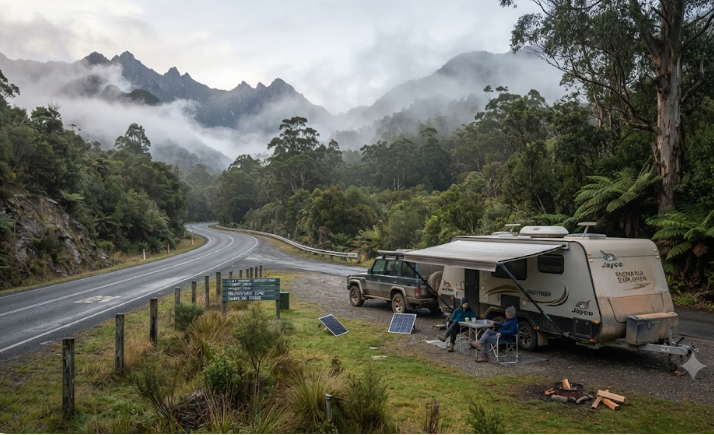
Free Camping Lyell Highway Tasmania — West Coast Grey Nomad Guide 2026
The Lyell Highway is one of Australia’s most dramatic drives — and one of the least forgiving for unprepared travellers. This guide covers every free and low-cost overnight stop from the Derwent Valley to Queenstown and Strahan, with honest advice on fuel gaps, mobile blackspots, winding road fatigue, and what the standard listings never tell you.
Last reviewed: July 2026. Facilities and rules can change — confirm on arrival and check with local councils before your trip.
- Route: Hobart → New Norfolk → Hamilton → Ouse → Derwent Bridge → Queenstown → Strahan
- Road surface: Fully sealed — but extremely winding west of Derwent Bridge
- Self-containment: Required for all freedom camping in Tasmania
- Fuel warning: Up to 170 km between reliable fuel stops — fill up at every opportunity
- Mobile coverage: Telstra only, and patchy west of Ouse — Optus and Vodafone unreliable
- Best season: October to April — winter brings ice, fog, and reduced services
- Nearest hospital: Royal Hobart Hospital (Hobart) — (03) 6166 8308, or West Coast District Hospital (Queenstown) — (03) 6495 1550
📋 Table of Contents
- Location — Hobart to Strahan via the Lyell Highway
- Why Grey Nomads Stop Here — Route Context
- Can You Stay Overnight? Rules and Self-Containment
- Your Two Main Options Side by Side
- Free and Low-Cost Overnight Stops by Town
- Facilities Table — All Major Stops
- Road Access, Fuel Distances and Flood Risk
- Rig Size Suitability
- What the Lyell Highway Doesn’t Tell You Online
- Full Facilities Comparison — Free vs Paid
- Rates — All Camping Options Along the Route
- Senior-Friendly Things to Do
- Month-by-Month Weather and Best Time to Visit
- Wildlife and Nature
- Medical and Emergency Contacts
- Mobile Coverage by Carrier
- Fires, Generators and Overnight Etiquette
- Accessibility for Seniors
- Senior Packing Checklist — Lyell Highway
- Natural Circuit — Internal Links
- GPS Coordinates and Postcodes
- FAQ — Lyell Highway Camping
- Quick Verdict
- Quick-Reference Card
- Planning Tip and Internal Links
📵 Before You Set Up Camp: Can 000 Find You Here?
Most rest areas don’t have a street address. If something goes wrong overnight, “I’m at a rest stop somewhere past the servo” wastes precious minutes. Before you unhitch, open Emergency+ and check it can pin your GPS location or generate a what3words address right where you’re parked — it works offline, so no signal doesn’t mean no location. Get it free — iPhone (App Store) or Android (Google Play).
The habit that matters: do this the moment you arrive, not if you need it. Signal drops in and out at bush camps — testing it early means you already know it works before an emergency makes that the wrong time to find out.
Bonus use: while you’re in the app, grab the GPS coordinates it shows you and save them to your own Van Life Savings Spots pin — a good stop is worth remembering for next time, and now you’ve already got the exact coordinates in hand.
Location — Hobart to Strahan via the Lyell Highway
The Lyell Highway (A10) is Tasmania’s primary overland route to the West Coast. It begins in Hobart’s outer suburbs and runs north-west through the Derwent Valley before climbing into the Central Highlands and descending dramatically into Queenstown. From Queenstown, the road continues to Strahan on Macquarie Harbour.
The total distance from Hobart to Strahan is approximately 240 kilometres. Allow at least four to five hours driving time — more with stops. The distance is deceptive. The western half of the highway winds through steep mountain terrain with tight switchbacks, narrow lanes, and grades that demand low gears. A caravan or motorhome adds significant time to any schedule.
Key towns along the route include New Norfolk, Hamilton, Ouse, and Tarraleah before reaching Derwent Bridge. Derwent Bridge marks the edge of the Central Highlands and the true gateway to the West Coast. From there it is approximately 98 kilometres to Queenstown, and a further 40 kilometres from Queenstown to Strahan.
📍 Route Reference Points — Lyell Highway
Derwent Bridge (township):
-42.0505, 146.2273
Queenstown (town centre):
-42.0833, 145.5500
Strahan (town centre):
-42.1536, 145.3278
⚠ GPS note: Coordinates are within 50 metres of the stated location and are provided as navigation guidance only. Always confirm on arrival against current signage.
Why Grey Nomads Stop Here — Route Context
The Lyell Highway is not a destination in itself — it is the corridor that unlocks Tasmania’s remote West Coast. For grey nomads completing a Tasmanian circuit, this route connects the central highlands to Strahan, the Gordon River, and the wild southwest wilderness.
Most travellers underestimate the route. They see 240 kilometres and think half a day. In reality, this is a full-day drive when towing. The terrain demands it. So does the scenery — pulling over to photograph the King William Range or the descent into Queenstown adds time that is genuinely worth taking.
The three key overnight towns — Derwent Bridge, Queenstown, and Strahan — each serve a different purpose for travellers. Derwent Bridge is a resupply and rest point. Queenstown is a heritage town with full facilities. Strahan is the tourism base for Gordon River cruises and the Wilderness Railway.
Free camping options on this route are limited. Tasmania has strict self-containment rules. Many of the informal spots used a decade ago no longer exist or are no longer tolerated. This guide focuses on the legitimate, confirmed options and is honest about what they offer.
Can You Stay Overnight? Rules and Self-Containment
Tasmania requires self-contained certification for freedom camping in most areas. This means a certified grey water containment system, a fixed toilet, and no discharge onto the ground. A portable toilet in a bag is not sufficient at most Tasmanian managed sites.
The rules vary by land manager. Parks and Wildlife Service areas have their own fee and permit structures. Council-managed rest areas have different rules again. Some roadside stops on the Lyell Highway are managed by the Department of State Growth (road reserve) and permit short-term overnight stops — but rules are subject to change and should be verified before relying on any specific spot.
Tasmania does not have a blanket freedom camping law like some mainland states. Each site is governed by the authority that manages it. When in doubt, contact the relevant local council or Parks and Wildlife Tasmania directly.
The West Coast Council manages the Queenstown and Strahan areas. Derwent Bridge falls within the Central Highlands Council area. Contact details for both councils are listed in the Medical and Emergency section below.
Your Two Main Options Side by Side
On the Lyell Highway, the honest choice is between free or low-cost informal overnight stops — mostly rest areas and designated free camps — and the paid caravan parks in the three main towns. Here is the direct comparison.
| Factor | Free / Low-Cost Stop | Paid Caravan Park |
|---|---|---|
| Cost | Free or under $15 per night | $35–$65+ per night (unpowered to powered) |
| Toilets | Basic pit toilet at some stops — none at others | Full amenities block with flush toilets |
| Showers | None at free stops | Hot showers included |
| Power | None | Available (powered sites) |
| Dump point | Not available at roadside stops | Usually available on-site or nearby |
| Water | Not guaranteed — carry your own | Potable water on-site |
| Security | Isolated — no staff, no lighting | Staffed, lit, other travellers nearby |
| CPAP suitability | Battery or solar required — no mains power | Powered sites support CPAP directly |
| Noise | Traffic noise at roadside stops | Quieter, set back from highway |
| Booking required | No — turn up | Advisable in peak season (Dec–Feb) |
| Best for | Self-sufficient rigs, one-night transit stops | Multi-night stays, CPAP users, those wanting comfort |
Our recommendation: If you are CPAP-dependent, travelling in winter, or planning a multi-night stay near Strahan, book a powered site at a caravan park. The free options on this route are transit stops — functional, legal, and free — but they are not comfortable base camps. Use them when you need to break the drive, not as a replacement for a real rest.
Free and Low-Cost Overnight Stops by Town
Derwent Bridge — Gateway to the West Coast
Derwent Bridge sits at the junction of the Lyell Highway and the road into Cradle Mountain via Lake St Clair National Park. It is approximately 172 kilometres from Hobart. At this elevation, expect cold nights year-round — and genuine frost and ice from May through September.
The township itself is small — a pub, a basic store, and limited fuel. It is not a town in the conventional sense. It is a service point at a remote crossroads.
Lake St Clair National Park is immediately adjacent. Camping within the park requires a National Parks pass and fees apply. The Cynthia Bay camping area inside the park is the most accessible option near Derwent Bridge, with toilets and basic facilities — but it is a paid park camp, not a free stop.
Roadside rest areas near Derwent Bridge exist along the Lyell Highway but should be treated as short transit stops rather than overnight destinations. Confirm their current status with the Central Highlands Council before relying on them. Do not assume any roadside pullout is a designated overnight stop.
Queenstown — Mining Heritage Town with Full Facilities
Queenstown is the only town of significant size on the West Coast between Hobart and Strahan. It has a supermarket, fuel, a hospital (West Coast District Hospital — (03) 6495 1550, confirm current details locally), pharmacy, and multiple accommodation options.
Queenstown’s surroundings are striking — the bare, mineral-coloured hills around the town are the result of historic copper smelting and are now a heritage landscape. The town itself is functional rather than scenic, but it is genuinely useful as a service base.
The Queenstown Caravan Park operates in town and is the most practical overnight base for caravans and motorhomes. Confirm current rates and availability directly — details change and this guide will not fabricate pricing that may be out of date.
Free camping in Queenstown is limited. The West Coast Council does not designate specific free camping areas in the Queenstown township as of July 2026 — confirm this with the council directly, as policy can change. Do not assume a free option exists in town without checking.
Strahan — West Coast Harbour Town and Tourist Base
Strahan is the main tourist hub on the West Coast. It sits on Macquarie Harbour — one of the world’s largest harbours by area — and is the departure point for Gordon River cruises and the Wilderness Railway to Queenstown.
Strahan has a caravan park, fuel, a small supermarket, restaurants, and a visitor centre. It is a genuine tourist town and the most comfortable base on this route.
Free camping is not available in Strahan township. The West Coast Council manages the area and does not designate free camping within the town. The nearest low-cost option is the Strahan Holiday Retreat or similar commercial parks — confirm current rates and options directly.
Strahan is worth at least two nights. The Gordon River cruise alone takes a full day. The West Coast Wilderness Railway day trip to Queenstown is a half to full day. Budget time, not just kilometres, when planning your Strahan stay.
Facilities Table — All Major Stops Along the Route
| Location | Toilets | Water | Dump Point | Showers | Power | Shade | Bins | Fires | Cost |
|---|---|---|---|---|---|---|---|---|---|
| Ouse Roadside Stop (approx.) | Basic pit | No | No | No | No | Limited | No | No | Free (transit) |
| Derwent Bridge Roadside Area | Confirm locally | No | No | No | No | Some trees | No | No | Free (transit) |
| Lake St Clair / Cynthia Bay (Parks) | Yes — flush | Yes | Confirm locally | Yes | No | Yes | Yes | Fire pits — check conditions | Paid (Parks pass + camping fee) |
| Queenstown Caravan Park | Yes — flush | Yes | Confirm locally | Yes | Yes (powered sites) | Yes | Yes | No open fires in town | Paid |
| Strahan (commercial parks) | Yes — flush | Yes | Confirm locally | Yes | Yes (powered sites) | Yes | Yes | Check park rules | Paid |
Road Access, Fuel Distances and Flood Risk
Road Surface
The Lyell Highway is fully sealed for its entire length from Hobart to Strahan. There are no unsealed sections on the main route. However, “sealed” does not mean easy. The surface quality varies. Sections through the mountains can be narrow, with no kerbing and steep drop-offs on corners. Some passing bays exist for overtaking — use them.
Does the Road Flood?
The Lyell Highway can be closed during severe weather events, particularly in winter and early spring. Heavy rainfall in the highlands can cause landslips and temporary road closures. The Derwent River system and its tributaries occasionally flood low-lying sections east of Derwent Bridge.
Check road conditions before departure at the Tasmania Department of State Growth traffic alerts website or by calling the Tasmanian road conditions line. Do not assume the road is clear in winter without checking — particularly if travelling with a heavy rig that cannot easily turn around.
Fuel Distances
Fuel planning is the single most important logistical element of the Lyell Highway. Services are genuinely sparse. Treat every fuel stop as mandatory — do not skip one thinking the next will appear soon.
| From | Direction | Next Fuel | Approximate Distance | Notes |
|---|---|---|---|---|
| Hobart | West / North-West | New Norfolk | ~38 km | Reliable fuel — fill up here before heading west |
| New Norfolk | West | Hamilton or Ouse | ~55–75 km | Hamilton has a small service station — confirm hours locally |
| Ouse / Hamilton | West | Derwent Bridge | ~55–70 km | Derwent Bridge fuel — confirm availability locally, not guaranteed |
| Derwent Bridge | West | Queenstown | ~98 km | No fuel between Derwent Bridge and Queenstown — this gap is critical |
| Queenstown | West | Strahan | ~40 km | Strahan has fuel — manageable gap |
| Strahan | East (return) | Queenstown | ~40 km | Fill up in Strahan before heading back east |
Road Fatigue and Senior Driver Considerations
The winding nature of the western section of the Lyell Highway is genuinely tiring. Constant steering corrections, steep grades, and tight bends require sustained concentration over a long stretch. Plan mandatory rest stops — not just fuel stops.
For drivers over 65, the recommendation is to split the Hobart-to-Strahan journey across two days minimum. Staying overnight at Derwent Bridge or Queenstown rather than pushing through in one session is strongly advisable. Fatigue-related errors on this road, with drop-offs and no safety barriers on some sections, carry serious consequences.
Rig Size Suitability
The Lyell Highway is technically passable by most rigs — but the western section tests the limits of larger combinations. Here is an honest size breakdown.
| Rig Type | Suitability | Notes |
|---|---|---|
| Campervan / small motorhome (under 7 m) | ✅ Good | Handles the winding sections well — most manageable option |
| Mid-size motorhome (7–10 m) | ✅ Generally fine | Take corners slowly — some tight bends on the descent to Queenstown |
| Caravan + tow vehicle (standard) | ⚠ Proceed with caution | Manageable but demanding — steep grades, tight switchbacks, check brake capacity |
| Large A-class motorhome (over 10 m) | ⚠ Difficult | Not recommended on the Queenstown descent without prior research — narrow passing bays, limited turning space |
| Fifth-wheel or long-wheelbase combination | ❌ Not recommended | The switchbacks and grades on the western section make large combinations genuinely hazardous — seek local advice before attempting |
| Road train / oversized vehicle | ❌ Not suitable | This is not a route for oversize loads |
Brakes matter more on this road than almost anywhere else in Tasmania. Have your brakes serviced and your electric brake controller calibrated before attempting the Lyell Highway with a caravan. The descent into Queenstown is steep and sustained. Overheated brakes on this section are a real risk if you have not checked your setup.
What the Lyell Highway Doesn’t Tell You Online
CamperMate listings, WikiCamps entries, and generic travel blogs cover the Lyell Highway in broad strokes. They will tell you it is scenic. They will mention Lake St Clair and the Gordon River. What they do not tell you is the operational detail that actually affects your trip. Here are the specific gaps.
1. The Derwent Bridge Fuel Trap
Multiple online listings and traveller forums mention Derwent Bridge as a fuel stop as if it is reliable. The reality is more complicated. The fuel supply at Derwent Bridge has historically been inconsistent — the pump has been out of service or the station closed at various times. This is a 98-kilometre gap before Queenstown on challenging terrain. If you arrive at Derwent Bridge and fuel is unavailable, you are facing a very uncomfortable decision with a heavy rig. The standard online guides do not flag this clearly enough. Carry a jerry can with at least 20 litres of reserve fuel when travelling west of Ouse.
2. The Mobile Blackspot Problem is Worse Than Most Guides Say
Between Derwent Bridge and Queenstown, mobile coverage is effectively absent for most of the journey — even on Telstra. Some coverage may exist on hilltops or at specific clearings, but you cannot rely on it. More importantly, if you are EPIRB or Personal Locator Beacon (PLB) dependent for emergency communication, you need to know that mobile voice and data will not save you in this corridor. Register a PLB and carry it. The standard travel guides mention “limited coverage” but rarely stress that a medical emergency in this section could leave you without any communication for hours before another vehicle passes.
3. The Queenstown Descent Requires Specific Preparation for Caravans
The descent into Queenstown — the final section of the Lyell Highway approaching the town from the east — involves a series of steep, tight switchbacks that most caravan guides underplay. The gradient is sustained and the curves are tight. Downhill braking with a heavy van over an extended distance generates significant heat in brake drums. Some travellers have experienced brake fade on this section. The standard advice is “take it slow” — but the specific advice is: check your brake controller settings, use engine braking in low gear, and stop at the top of the descent to test your brakes are fully functional before committing to the downhill. Do not rely on trailer brakes alone.
4. Wildlife Strike Timing is Hyper-Local on This Route
Wombats and wallabies are genuinely dangerous on the Lyell Highway. But the specific high-risk windows are dusk and dawn in the central highlands section — roughly between Ouse and Derwent Bridge — and along the Strahan road at night. The risk is not evenly distributed along the route. Most generic guides say “watch for wildlife” without identifying that the central highlands section at dusk is where the highest concentration of animal strikes occurs. Plan to be parked and settled before dusk if you are travelling this section. A wombat strike at 80 km/h will cause serious vehicle damage and potentially flip a caravan.
5. Dump Points Are Genuinely Scarce and Not Always Operational
The West Coast has limited waste infrastructure. Dump points in Queenstown and Strahan exist — but their operational status, access hours, and physical condition are not consistently maintained. Multiple traveller reports (as of early 2026) note that dump points on this route can be out of order without warning. Carry enough grey water tank capacity to complete the entire route without a dump — typically three to four days — and treat any dump point you find as a bonus rather than a planning assumption.
Full Facilities Comparison — Free vs Paid Options
| Facility | Free Roadside Stop (Lyell Hwy) | Lake St Clair / Cynthia Bay (Parks) | Queenstown Caravan Park | Strahan Commercial Park |
|---|---|---|---|---|
| Cost | Free | Parks pass + camping fee | Paid — confirm locally | Paid — confirm locally |
| Toilets | Basic pit or none | Flush toilets | Flush toilets | Flush toilets |
| Hot showers | No | Yes | Yes | Yes |
| Powered sites | No | No | Yes | Yes |
| Dump point | No | Confirm locally | Confirm locally | Confirm locally |
| Potable water | No — carry your own | Yes | Yes | Yes |
| Shade | Limited / variable | Yes — rainforest setting | Yes | Yes |
| Laundry | No | No | Confirm locally | Yes (most parks) |
| Booking required | No | Yes — Parks Tasmania | Advisable peak season | Yes — peak season |
| Suitable for CPAP | No (no power) | No (no power) | Yes (powered sites) | Yes (powered sites) |
| Wi-Fi | No | No | Confirm locally | Limited (confirm locally) |
Rates — All Camping Options Along the Route
Rates on the Lyell Highway route vary and change seasonally. The figures below are indicative as of July 2026. Always confirm current rates directly with the operator before booking.
| Option | Type | Approximate Rate (per night) | Notes |
|---|---|---|---|
| Lyell Highway roadside stops | Free camping (transit) | Free | Short-term stops only — no facilities at most |
| Lake St Clair / Cynthia Bay | Parks Tasmania camping | Camping fee + Parks pass — confirm at parks.tas.gov.au | Booking required — fills quickly in peak season |
| Queenstown Caravan Park | Powered / unpowered | Confirm directly with operator | Only caravan park option in Queenstown — book ahead in summer |
| Strahan Holiday Retreat / commercial parks | Powered / unpowered | Confirm directly with operator | Strahan parks book out quickly December–February |
| Derwent Bridge Wilderness Hotel | Motel / basic rooms | Confirm directly | Limited rooms — caravan parking on-site may be available — confirm |
Senior-Friendly Things to Do Along the Lyell Highway
This is a route, not a single destination. Senior-friendly activities are spread across the three main stops — and some of the best experiences require no walking at all.
Derwent Bridge — Lake St Clair Visitor Centre
The Parks Tasmania visitor centre at Cynthia Bay (Lake St Clair) is a flat, accessible facility with displays on the park’s ecology and Indigenous history. The short walk along the lake edge from the visitor centre is largely flat and suitable for most mobility levels. The lake ferry (seasonal — confirm availability) allows you to experience the lake without walking. Sit and watch the water from the accessible picnic area — on a clear day, the reflection of the surrounding mountains is extraordinary.
Queenstown — Heritage Walks and the Spion Kop Lookout
Queenstown’s town centre is walkable on flat footpaths. The Galley Museum documents the town’s copper mining history and is housed in a historic building — it is a seated, interpretive experience suitable for most visitors. The Spion Kop Lookout above the town offers panoramic views of the bare mineral hills — the access road is driveable, so you can park and view without walking a significant distance. Confirm road conditions locally before driving up, as the road is unsealed and can be rough for low-clearance vehicles.
Strahan — Gordon River Cruise (Seated, All-Day Experience)
The Gordon River cruise is one of the most accessible major wilderness experiences in Australia. You board a vessel in Strahan harbour and spend the day on the water — seated, catered, and narrated. You pass through Hells Gates, travel up the Gordon River through the Tasmanian Wilderness World Heritage Area, and dock at Heritage Landing for a short flat boardwalk through ancient Huon pine forest. The boardwalk at Heritage Landing is well-maintained and flat. This is specifically designed to be accessible. Book well in advance — Gordon River Cruises is the main operator and boats fill quickly from October through April.
Strahan — West Coast Wilderness Railway (Seated)
The Rack Railway from Strahan to Queenstown (or the reverse) is a historic rack-and-pinion railway through extraordinary mountain terrain. It is a fully seated experience. The journey takes several hours each way. You can do a return day trip or arrange one-way transfer. This is an exceptional experience for older travellers who want wilderness immersion without any physical exertion. Book directly with the operator and confirm accessibility features in advance.
Strahan Village — Flat Foreshore Walk
The Strahan foreshore is flat, paved, and easy to walk at any pace. The wharf precinct has cafes, the visitor centre, and interpretive displays about Macquarie Harbour’s convict history at Sarah Island. If the Gordon River cruise is not in the budget, the foreshore alone provides a half-day of gentle activity.
Month-by-Month Weather and Best Time to Visit
The Lyell Highway’s western section sits in one of the wettest and most weather-variable environments in Australia. The Central Highlands and West Coast receive very high annual rainfall, and conditions change quickly. Plan around the seasons, not just average temperatures.
| Month | Avg. Temp (Queenstown) | Rainfall | Crowd Level | Road Risk | Verdict |
|---|---|---|---|---|---|
| January | 12–20°C | Moderate | Very High | Low | Peak season — book ahead, roads good, busy |
| February | 12–20°C | Moderate | High | Low | Still busy — good weather window |
| March | 10–18°C | Moderate–High | Medium | Low | Good — crowds easing, weather still reasonable |
| April | 8–15°C | High | Low–Medium | Low–Medium | Shoulder season — cold nights, quieter, watch rain |
| May | 5–12°C | High | Low | Medium | Cold — frost possible — not ideal without good heating |
| June | 3–10°C | High | Very Low | High — ice risk | Avoid — ice on road, minimal services, very cold |
| July | 2–9°C | Very High | Very Low | High — ice, landslip | Avoid — worst month — road closures possible |
| August | 3–10°C | Very High | Very Low | High | Avoid — conditions similar to July |
| September | 5–12°C | High | Low | Medium–High | Early spring — conditions improving but still cold and wet |
| October | 8–15°C | Moderate–High | Low–Medium | Low–Medium | Good start to season — quieter, services reopening |
| November | 10–17°C | Moderate | Medium | Low | Recommended — good weather, manageable crowds |
| December | 11–19°C | Moderate | High | Low | Good weather — book ahead, holiday crowds building |
Our recommendation: October to November and March to April are the sweet spots for grey nomads on the Lyell Highway. The crowds are manageable. The roads are clear. The temperatures are cool but not dangerous. Avoid June through August unless you have a fully self-sufficient rig with excellent heating and the experience to handle icy roads.
Wildlife and Nature
The Lyell Highway traverses some of the most biodiverse wilderness in Australia. The wildlife is genuine, beautiful, and in some cases genuinely dangerous for drivers.
Wombats
Common bare-nosed wombats are present throughout the central highlands section. A wombat is a dense, low-slung animal that absorbs a vehicle strike differently to a kangaroo — it does not flinch aside. At highway speed, a wombat strike can cause significant undercarriage damage, puncture fuel tanks, or, in the worst case, cause a caravan to destabilise. Drive below 80 km/h in the hour before and after dusk through the Derwent Bridge corridor.
Wallabies and Pademelons
Bennett’s wallabies and pademelons are extremely common on this route, particularly in the rainforest sections near Strahan. They appear suddenly at road edges at dusk. They are faster than wombats but equally unpredictable. A strike at caravan speeds can cause significant damage to the front of a tow vehicle.
Spotted-Tail Quolls and Tasmanian Devils
Both species use road edges at night — often attracted to roadkill. They are unlikely to cause vehicle damage but are worth protecting by slowing down in known wildlife corridors. The Lyell Highway is identified as a high-risk zone for devil and quoll mortality.
Raptor Birds
Wedge-tailed eagles and other raptors frequently feed on roadkill along the highway. They are large birds and can be slow to lift clear of the road. Give them space — particularly at low speed — as a collision with a wedge-tail at speed can damage windscreens and front bodywork.
Vegetation and Fire Risk
The central highlands and West Coast are not traditional high-fire-risk areas by mainland standards. However, dry summers can create fire risk, and Total Fire Ban days are possible. Check the Tasmania Fire Service (TFS) website before lighting any fires. In most years, the wetter western section of the highway is not a fire concern — but check conditions for the central highlands section around Derwent Bridge.
Medical and Emergency Contacts
| Service | Location | Contact | Notes |
|---|---|---|---|
| Emergency Services | All locations | 000 | Use Emergency+ app to generate GPS coordinates for your location |
| West Coast District Hospital | Queenstown, TAS | (03) 6495 1550 | Nearest hospital to Derwent Bridge and Queenstown — limited services, not a major trauma centre |
| Royal Hobart Hospital | Hobart, TAS | Confirm locally — search healthdirect.gov.au | Major hospital — nearest major trauma centre to the entire route |
| Healthdirect (medical advice line) | National — phone service | 1800 022 222 | 24/7 nurse advice line — useful when mobile coverage is available and you need guidance before reaching hospital |
| Tasmania Police | State-wide | 131 444 (non-emergency) | For road incident reporting, welfare checks |
| Tasmania State Emergency Service | State-wide | 132 500 | For flood, storm, or other emergency not requiring police/ambulance |
| Tasmania Fire Service | State-wide | 1800 000 699 (information line) | Fire conditions and burn bans — confirm this number locally before departure |
| Central Highlands Council | Bothwell, TAS | Confirm locally — council.tas.gov.au directory | Manages Derwent Bridge area and central highlands roads |
| West Coast Council | Queenstown, TAS | Confirm locally — council.tas.gov.au directory | Manages Queenstown, Strahan, and surrounding West Coast area |
| Parks Tasmania | State-wide | Confirm at parks.tas.gov.au | For Lake St Clair bookings, park passes, and conditions |
Mobile Coverage by Carrier
Mobile coverage on the Lyell Highway is one of the most consistently misunderstood aspects of this route. Travellers arrive expecting coverage because Hobart and New Norfolk have good signal. The transition to no coverage is rapid once you pass Ouse heading west.
| Carrier | Hobart to Ouse | Ouse to Derwent Bridge | Derwent Bridge to Queenstown | Queenstown | Queenstown to Strahan | Strahan |
|---|---|---|---|---|---|---|
| Telstra | Good | Patchy | Very limited / absent | Limited (in-town) | Very limited | Limited (in-town) |
| Optus | Good to New Norfolk | Poor | Absent | Very limited | Absent | Very limited |
| Vodafone / TPG | Good to New Norfolk | Poor | Absent | Very limited | Absent | Very limited |
Telstra is the only realistic option for any coverage west of Ouse. Even Telstra coverage is not reliable or continuous. Do not plan your emergency communication around mobile phone availability on this route.
Recommended alternatives for this route:
- Personal Locator Beacon (PLB): Register before departure with the Australian Maritime Safety Authority (AMSA). A PLB works anywhere in Australia regardless of mobile coverage.
- Satellite communicator: Devices such as the Garmin inReach operate via satellite and provide two-way messaging and SOS capability independent of phone towers.
- Emergency+ app: Download before departure. It works offline to generate GPS coordinates even without mobile signal — but you need signal to actually make a call.
Fires, Generators and Overnight Etiquette
Open Fires
Open fires are not permitted at most roadside stops on the Lyell Highway. In National Parks areas (Lake St Clair), fire restrictions apply and conditions vary by season and fire danger rating. Check the Parks Tasmania website and the Tasmania Fire Service website before lighting any fire anywhere on this route.
Even where fires are technically permitted, the West Coast environment is sensitive. Carry a camp stove. Do not collect firewood from the roadside — it is typically illegal in National Park adjacent areas and ecologically damaging. If you want a campfire experience, plan it at a designated facility with a fire pit and firewood supply.
Generators
Generators are not appropriate at roadside stops or in quiet areas near residential communities like Queenstown and Strahan. In caravan parks, check park-specific generator hours — most allow use for limited hours in the morning and evening only. Run your generator considerately. The West Coast towns are small and noise carries easily.
Overnight Etiquette at Roadside Stops
If you stop overnight at a roadside rest area, park fully within the designated area, leave no waste, and keep lights and noise to a minimum. These are transit facilities — not campgrounds. Other drivers stop throughout the night. Arrivals at 2 am are common on remote highways. Park in a way that does not block others or prevent other vehicles from using the rest area.
Accessibility for Seniors and Mobility Considerations
Honest assessment: the Lyell Highway route is not among Tasmania’s most accessible for travellers with significant mobility limitations. Here is the specific breakdown.
What Works Well
- Gordon River cruise — accessible boarding, seated experience, flat boardwalk at Heritage Landing
- Strahan foreshore — flat, paved, suitable for wheelchairs and walking frames
- Queenstown town centre — largely flat, accessible footpaths
- Lake St Clair visitor centre — accessible building with flat lake-edge area
- West Coast Wilderness Railway — seated, no walking required during the journey
What is Genuinely Difficult
- Most free roadside stops have no accessible toilets — or no toilets at all
- Rest areas are basic gravel or concrete pads with no level ground guarantee
- Entering and exiting a van on an uneven roadside can be hazardous in wet conditions
- The descent into Queenstown requires the driver to maintain concentration for an extended period — not suitable if you are managing fatigue, vertigo, or vision limitations
- Medical evacuation from the West Coast takes time — this route is not appropriate for anyone in an unstable medical condition
CPAP Users
Powered sites in Queenstown and Strahan caravan parks are the only reliable solution for CPAP users on this route. A large battery bank (100 Ah lithium minimum) combined with solar can extend CPAP operation for one to two nights off-grid — but the West Coast is not a high-sun environment, particularly in autumn and winter. Prioritise powered sites if CPAP is non-negotiable.
Medication Storage
Temperatures on the Lyell Highway can drop below 5°C overnight even in summer at higher elevations. Insulin and some other medications require temperature-stable storage. Check your medication’s cold storage requirements. A 12-volt fridge set to a stable temperature is more reliable than passive storage in a cold van overnight in the highlands.
Senior Packing Checklist — Lyell Highway Specific
☐ Jerry Can with 20+ Litres Spare Fuel
The Derwent Bridge to Queenstown gap is approximately 98 km on steep, winding terrain that increases fuel consumption significantly. A jerry can with 20 litres of reserve fuel eliminates the risk of running out if Derwent Bridge fuel is unavailable — which has occurred previously without warning.
☐ Personal Locator Beacon (PLB) — Registered with AMSA
The western section of the Lyell Highway has no reliable mobile coverage. A registered PLB is the only communication device that guarantees emergency notification regardless of phone signal. Register it at beaconregistration.amsa.gov.au before departure, not when you arrive.
☐ Emergency+ App — Installed and Tested Before Departure
Download and open the app in Hobart or New Norfolk while you still have reliable signal. Confirm it can read your GPS coordinates correctly. Once you are in the mobile blackspot west of Ouse, you cannot troubleshoot an app that isn’t working.
☐ Full Water Tank — Topped Up at Last Town
Roadside stops on the Lyell Highway do not supply potable water. Fill your tank completely at New Norfolk, Hamilton, or Ouse before heading west. Between Derwent Bridge and Queenstown, there is no guaranteed water supply at any roadside stop.
☐ Warm Bedding — Rated to at Least 0°C
Even in summer, nights at Derwent Bridge elevation can drop to near freezing. A sleeping bag or doona rated to 0°C or lower protects against unexpected temperature drops — particularly at unserviced roadside stops where you have no heating backup if your van’s heating system fails.
☐ Large Grey Water Tank or Extra Container
Dump points on the Lyell Highway route are scarce and not always operational. Plan to carry your grey water for up to three to four days without access to a dump. Know your grey water tank capacity before you leave — filling it faster than expected on a remote route with no dump access is a serious logistical problem.
☐ Brake System Check — Completed Before Departure
The descent into Queenstown is steep and sustained. Overheated brakes on this section are a documented risk with heavily loaded caravans. Have your brake drums or discs and your electric brake controller checked and set by a qualified mechanic before this trip — not just once a year, specifically before the Lyell Highway.
☐ Medication Supply for Extra Days
West Coast pharmacies are limited. Strahan and Queenstown have pharmacy services — but stock is limited and prescription medications may not be available. Carry a minimum of five days’ extra supply beyond your planned itinerary. Remote route weather delays are not uncommon in winter and shoulder season.
☐ Tyre Repair Kit and Inflation Equipment
There are no tyre services between Derwent Bridge and Queenstown. A tyre puncture in this corridor means you rely entirely on your spare and repair capability. Carry a full-size spare, a plug repair kit, and a 12-volt compressor — not just a can of tyre inflator.
☐ Offline Maps — Downloaded Before Departure
Google Maps and most mapping apps require mobile data to load detailed route information. Download the entire Lyell Highway corridor offline before leaving Hobart — including the Queenstown and Strahan sections. In the mobile blackspot west of Ouse, offline maps are your only navigation option beyond a printed map.
☐ High-Visibility Rain Gear
The West Coast receives some of the highest rainfall in Australia. If you need to attend to your rig or walk outside in wet conditions on or near the Lyell Highway, high-visibility rain gear makes you visible to oncoming traffic — particularly important at narrow sections with no shoulder.
☐ Advance Bookings for Strahan (Peak Season)
If you are travelling December through February, confirm that Strahan caravan park bookings are secured before you reach Queenstown. Strahan parks fill completely during peak summer and finding accommodation on arrival is frequently impossible. The West Coast Wilderness Railway and Gordon River Cruise also sell out — book these well in advance.
Natural Circuit — Plan Your Wider Tasmanian Route
The Lyell Highway is most rewarding as part of a longer Tasmanian circuit. It connects naturally with routes north and south, allowing grey nomads to loop the island rather than backtracking.
A logical circuit from Hobart runs west via the Lyell Highway to Strahan, then north to Zeehan and Queenstown, up through Cradle Mountain to Devonport or Launceston, east along the north coast, and south back through the Midlands Highway to Hobart. This circuit covers most of Tasmania’s major destinations without retracing significant ground.
For detailed planning of free and low-cost stops across the broader Tasmanian circuit, the Free Camping Tasmania guide covers the state’s best overnight options in one place. Use it alongside this guide to plan the full loop.
For strategies to stretch your budget across a longer Tasmanian trip — including which stops genuinely save money versus which ones cost more than they appear — the Van Life Savings Spots guide is worth bookmarking before you leave.
GPS Coordinates and Postcodes
| Location | GPS Coordinates | Postcode | Notes |
|---|---|---|---|
| Derwent Bridge (township) | -42.0505, 146.2273 | 7140 | Junction of Lyell Hwy and Lake St Clair road — confirm on arrival |
| Lake St Clair / Cynthia Bay (Parks) | -42.1036, 146.1657 | 7140 | Visitor centre and camping area — confirm on arrival against current signage |
| Queenstown (town centre) | -42.0833, 145.5500 | 7467 | Main street — navigate to caravan park directly using park address |
| Strahan (town centre / wharf) | -42.1536, 145.3278 | 7468 | Main wharf precinct — Gordon River Cruise departs from here |
| Ouse (township) | -42.4833, 146.7167 | 7140 | Last reliable fuel stop heading west before Derwent Bridge |
| New Norfolk (township) | -42.7833, 147.0500 | 7140 | Reliable fuel and services — fill up here heading west |
⚠ GPS note: Coordinates are within 50 metres of the stated location and are provided as navigation guidance only. Always confirm on arrival against current signage.
FAQ — Free Camping Lyell Highway Tasmania
Is there free camping on the Lyell Highway in Tasmania?
There are roadside rest areas along the Lyell Highway that permit short-term overnight stops, but genuine designated free camping with facilities is limited. Most roadside stops on this route are transit rest points — a sealed or gravel pullout, sometimes with a basic pit toilet, but no water, no power, and no dump point. These are legally usable for an overnight stop in a self-contained vehicle, but they are not campgrounds. The only nearby option with camping facilities is Lake St Clair / Cynthia Bay, which is a paid Parks Tasmania campground. Queenstown and Strahan both have commercial caravan parks. True free camping in the sense that many grey nomads expect — a designated free camp with toilets and water — does not reliably exist along this route. Always confirm the current status of any roadside stop with the relevant council before relying on it.
Do I need to be self-contained to camp on the Lyell Highway?
Yes. Tasmania has strict self-containment requirements for freedom camping, and the Lyell Highway route is no exception. Self-containment means your vehicle must have a certified grey water containment system, a fixed toilet, and no discharge onto the ground. A portable toilet in a bucket or bag does not meet the standard for most managed sites. If your vehicle is not certified self-contained, your options are limited to paid campgrounds with amenity blocks. Do not assume a roadside stop is exempt from these requirements — it is not. Fines apply.
How long does it take to drive the Lyell Highway from Hobart to Strahan?
Allow a minimum of four to five hours driving time without stops, and significantly more with a caravan or motorhome. The western half of the highway — particularly the section from Derwent Bridge to Queenstown — involves steep grades, tight switchbacks, and sections where speed is limited by road geometry rather than posted limits. Travellers towing a caravan regularly report six to seven hours total travel time including fuel and rest stops. Do not attempt the full Hobart-to-Strahan journey in one session with a caravan unless you are an experienced driver of that specific rig on mountain roads. The recommendation is to break the journey at Derwent Bridge or Queenstown.
Where can I get fuel on the Lyell Highway?
Fuel is available at New Norfolk, Hamilton (small station — confirm hours), Ouse, Derwent Bridge (confirm availability — not always reliable), Queenstown, and Strahan. The critical gap is approximately 98 kilometres between Derwent Bridge and Queenstown, through steep mountain terrain that increases fuel consumption. Never rely on Derwent Bridge fuel being available without calling ahead. Carry a minimum of 20 litres of spare fuel in a jerry can when travelling west of Ouse. Fill to capacity at every opportunity — this is not a route to be caught short on fuel.
Is there mobile coverage on the Lyell Highway?
Mobile coverage on the Lyell Highway is minimal west of Ouse and effectively absent between Derwent Bridge and Queenstown. Telstra provides the best coverage of any carrier, but it is not continuous or reliable on the western section. Optus and Vodafone/TPG have very limited or no coverage west of the Derwent Valley. Do not plan emergency communication around mobile phone availability on this route. Carry a registered Personal Locator Beacon (PLB) or a satellite communicator (such as a Garmin inReach) as your primary emergency communication device. The Emergency+ app works offline to generate GPS coordinates but cannot make a call without signal.
What is the nearest hospital to the Lyell Highway?
The nearest hospital to the western section of the Lyell Highway is the West Coast District Hospital in Queenstown. This is a small district hospital with limited services. It is not a major trauma centre. In a serious medical emergency — cardiac, major trauma, stroke — evacuation to Royal Hobart Hospital, approximately 200 kilometres away, may be required. This is either a long road journey or an air ambulance response. West Coast District Hospital’s main line is (03) 6495 1550 — still worth confirming before departure, as small regional hospital contact details can change. This reality — that major medical intervention is hours away from most of this route — is a genuine consideration for travellers with serious cardiac history or complex medical conditions.
Is the Lyell Highway suitable for large caravans or fifth-wheelers?
Standard caravans towed by SUVs and utes are manageable on the Lyell Highway with appropriate preparation — checked brakes, correct electric brake controller calibration, and a careful approach to the Queenstown descent. Large A-class motorhomes over 10 metres should research specific turning radii and road width limitations before committing, particularly on the switchbacks approaching Queenstown. Fifth-wheel combinations and very long rigs are not recommended for the western section — the tight bends and steep grades make long combinations genuinely hazardous. Seek specific local advice from the West Coast Council or experienced travellers who have driven your rig size before attempting this route.
What is the best time of year to drive the Lyell Highway?
October through April is the recommended window for grey nomads driving the Lyell Highway. The best balance of good weather, manageable crowds, and open services is in November and March to April. December through February offers the most reliable weather but the highest tourist volumes — Strahan in particular books out well in advance during this period. Avoid June through August. The western section of the Lyell Highway is prone to ice, frost, and road closures from landslips in winter. Services in Queenstown and Strahan are reduced. The combination of cold, wet, dangerous roads and limited emergency services makes winter travel on this route inadvisable for most grey nomads, particularly those travelling solo or with health considerations.
Are there dump points on the Lyell Highway?
Known dump points exist in Queenstown and Strahan, but their operational status, access hours, and condition are not consistently reliable. The West Coast has limited waste infrastructure, and dump points can be out of service without published notice. Use the Dump Point Finder at dumppoints.com.au or the Hema Explorer app to identify current options before departure — and treat any dump point as a bonus rather than a planning assumption. Grey water tank capacity to cover three to four days without a dump is advisable on this route.
Quick Verdict
The Lyell Highway — Honest Assessment for Grey Nomads:
The Lyell Highway is one of Australia’s great drives and one of its most demanding for older travellers in heavy rigs. The scenery is extraordinary. The West Coast is genuinely remote and wild. But this is not a route to take casually.
Free camping on this route is limited to basic roadside transit stops — functional and legal, but not comfortable base camps. Budget for at least some paid nights, particularly in Queenstown and Strahan, where powered sites and full amenities make the difference between a good trip and an exhausting one.
Plan fuel stops meticulously. Carry a PLB. Split the drive across two days minimum. Check your brakes before the Queenstown descent. Accept that mobile communication may not exist for long stretches.
If you do this route prepared, it will be among the most memorable drives of your Australian van life journey. If you do it underprepared, it will be among the most stressful. The planning you do in Hobart determines which one you get.
Recommended for: Experienced grey nomads with well-prepared, self-sufficient rigs travelling October to April.
Not recommended for: First-time caravan towers, travellers with unstable medical conditions, large fifth-wheel combinations, or anyone planning a winter transit without extensive cold-weather preparation.
Quick-Reference Card — Screenshot and Save
| Factor | Detail |
|---|---|
| Route | Hobart → New Norfolk → Hamilton → Ouse → Derwent Bridge → Queenstown → Strahan |
| Total distance | ~240 km (Hobart to Strahan) |
| Drive time (caravan) | 6–7 hours including stops — split across 2 days recommended |
| Road surface | Fully sealed — steep and winding west of Derwent Bridge |
| Critical fuel gap | Derwent Bridge to Queenstown ~98 km — carry 20 L spare |
| Mobile coverage | Telstra only — absent Derwent Bridge to Queenstown — carry PLB |
| Free camping | Roadside transit stops only — basic, no facilities — self-contained required |
| Nearest hospital | West Coast District Hospital, Queenstown — (03) 6495 1550 |
| Dump points | Queenstown and Strahan — verify at dumppoints.com.au before relying on them |
| Best season | October to April — avoid June to August |
| CPAP users | Book powered sites in Queenstown and Strahan — no power at free stops |
| Wildlife risk | High at dusk — wombats and wallabies — park before dusk on remote sections |
| Self-containment | Mandatory — certified grey water system and fixed toilet required |
| Emergency | 000 — use Emergency+ app for GPS coordinates — PLB for blackspot areas |
These guides will help you build a complete Tasmanian circuit:
- Free Camping Tasmania — the full state overview of free and low-cost overnight stops for grey nomads
- Van Life Savings Spots — strategies for stretching your budget on a longer Tasmanian trip
COPY PROMPT ➔ ASK AI ➔ SAVE TO FORM ➔ ADD SPOT PIN ➔ GET DIRECTIONS
📍 Interactive map — find free camps, rest areas and overnight stops. Enable location for best results.

As an affiliate, I earn from qualifying purchases at no extra cost to you.
Exclusive Offer: Get 5% OFF all StarterStopper immobiliser products with promo code: RTV5
Visit StarterStopper.com to see our data-backed security solutions
As an affiliate, I earn from qualifying purchases at no extra cost to you.