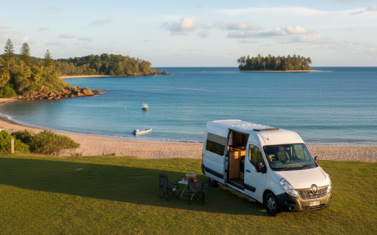
Bowen is one of Queensland’s best-kept secrets — a genuine tropical beach town surrounded by seven stunning beaches, fringing coral reef, and the vast blue of the Whitsunday Coast, all less than five minutes off the Bruce Highway. Your practical, retiree‑friendly guide to free camps, water points, dump points, fuel stops, Wi‑Fi, medical access, disability access and safety around Bowen. Whether you’re a grey nomad, caravanner or vanlifer, this guide gives you accurate GPS coordinates, access notes, amenities and local insights to help you travel confidently and comfortably.
Free Camping Near Bowen (Best Retiree‑Friendly Spots)
Bowen sits roughly halfway between Mackay and Townsville on the Bruce Highway, making it a natural and genuinely rewarding stop on the great Queensland grey nomad run. The honest reality of free caravan camping Bowen is that the town itself has been known to strictly enforce no-free-camping rules within the township — so this guide focuses on the best legitimate options in the region, which include the excellent Whitsunday Regional Council free RV parks at Bowen Showgrounds and Proserpine, the extraordinary free camp at Peter Faust Dam, the donation-based Funny Dunny Park north of town, and the Guthalungra Rest Area on the Bruce Highway. One caravanner who’d been stopping in Bowen every winter for a decade told us the beaches here rival anything in the Whitsundays — and she’d stopped paying to stay in Airlie Beach years ago.
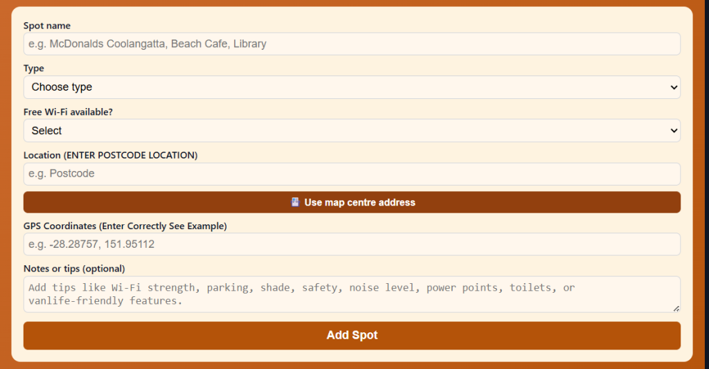
Use the Vanlife Savings Spots App to save your locations. Add your postcode, GPS coordinates and notes, then tap “Add Spot” to place it on the map and get directions.
Bowen Showgrounds RV Park – Bowen QLD 4805
Distance from Bowen: 0 km — within Bowen township Maximum Stay: Check current Whitsunday Regional Council rules on arrival — typically 48 hours; verify before visiting Self‑Contained Required: Yes — self-contained vehicles only; no facilities for non-self-contained travellers Toilets On‑Site: No — self-contained only; public toilets available nearby in town Toilet Address: Bowen CBD — various public facilities within 500 m of showgrounds Toilet GPS: -20.0108, 148.2464 (approx. Bowen CBD) Showers: No Pet‑Friendly: Yes — dogs on lead Caravan‑Friendly / Big‑Rig Access: Yes — large showgrounds area; good turning space Campervan Access: Yes Camper Trailer Access: Yes Tent Camping Allowed: No — self-contained vehicles only Vehicle Restrictions: Self-contained motorhomes and caravans only Telstra Reception: Yes — good in-town coverage GPS: -20.0108, 148.2464 (Public mapping data) Address: Showgrounds Road, Bowen QLD 4805 Coordinate Source: Public mapping data
Note: This is a Whitsunday Regional Council free RV park. Self-contained vehicles only — strictly enforced. Rangers patrol and fines of $280+ have been reported for non-compliance. Verify current rules and any changes to hours or access with Whitsunday Regional Council (1300 972 744) before arriving.
Accessibility (Disability‑Friendly Notes)
- Wheelchair-accessible toilets: No on-site toilets — use accessible facilities in the Bowen CBD (within 500 m)
- Accessible parking: Yes — large flat showgrounds area
- Pathway surface: Gravel and grass; mostly flat
- Mobility-friendly access to amenities: Moderate — no on-site facilities; town accessible within short drive or walk
- Turning space for mobility devices: Good — large open area
- Suitability for travellers with limited mobility: Moderate — flat site but no on-site toilet; own self-contained facilities required
- Nearby accessible toilets: Bowen CBD, various locations within 500 m
- Emergency toilet options within 1–5 km: Bowen CBD
Access Notes
- Road type: Sealed road through Bowen township to showgrounds
- Turning space: Excellent — large open showgrounds area
- Caravan/motorhome suitability: Good — large rigs have been accommodated
- Vehicle limitations: Self-contained vehicles only — no exceptions
Why Retirees Like It
The Bowen Showgrounds RV Park puts you right in the heart of Bowen, walking distance from the main street, shops, café, bakery and supermarket. It’s free, it’s flat, and it gives you an excellent overnight base from which to explore all seven beaches. The key is being genuinely self-contained — tanks, toilet, grey water all fully contained. The Bowen Visitor Information Centre is just a short drive away on Bruce Highway for maps and local advice. RV friendly Bowen travellers who are set up properly find this site extremely convenient.
Nearby Public Wi‑Fi Options
Bowen Library – Bowen QLD 4805 Address: 16 Powell St, Bowen QLD 4805 Free Wi‑Fi: Yes Toilets: Yes — accessible Toilet Address: 16 Powell St, Bowen QLD 4805 Toilet GPS: -20.0108, 148.2464 (approx.) Parking suitability: Good — street parking; suitable for campervans Wi‑Fi GPS: -20.0108, 148.2464 Parking GPS: -20.0108, 148.2464
Driving Directions
➡ From Bruce Highway, turn east into Bowen via Don or Powell Street ➡ Follow signs to the Showgrounds — Showgrounds Road is signed from the main street ➡ Large flat area — park within the showgrounds boundary
Tips
- Self-containment: This is strictly enforced — rangers issue $280+ fines; do not attempt without genuine self-containment
- Arrival time: Afternoon is fine — less popular than peak highway camps
- Maximum stay: Verify current limit with council before visiting — 48 hours typical
- Safety: In-town location; safe and well-supervised
- Wet season notes: January–March; cyclone risk; monitor BOM warnings
Funny Dunny Park (Wunjunga) – Inkerman QLD 4806
Distance from Bowen: Approx. 25 km south, then east — 5 km south of Inkerman off the Bruce Highway Maximum Stay: Donation-based — no formal limit noted; please donate generously Self‑Contained Required: No — toilets on site Toilets On‑Site: Yes — non-potable water also on site (not drinking water) Toilet Address: Wunjunga Road, Inkerman QLD 4806 — look for the “Wunjunga” signpost Toilet GPS: -19.7533, 147.5958 (approx. — 19°45’8″S, 147°35’45″E) Showers: No Pet‑Friendly: Yes — dogs welcome Caravan‑Friendly / Big‑Rig Access: Yes — 2WD accessible; suitable for big rigs, caravans, motorhomes, camper trailers Campervan Access: Yes Camper Trailer Access: Yes Tent Camping Allowed: Yes Vehicle Restrictions: None noted — wide, open area Telstra Reception: Limited — check coverage; carry a satellite device for remote areas GPS: -19.7533, 147.5958 (Public mapping data) Address: Wunjunga Road, via Inkerman QLD 4806 — turn off the Bruce Highway 5 km south of Inkerman and look for the Wunjunga signpost Coordinate Source: Public mapping data
Note: This is a community-run donation-based camp. The “Funny Dunny” is a decorated, well-known landmark visible from the approach — you will immediately understand the name when you see it. Please donate at the donation box on site to help maintain the facility.
Accessibility (Disability‑Friendly Notes)
- Wheelchair-accessible toilets: Not confirmed — basic facilities; verify on arrival
- Accessible parking: Yes — flat open coastal area
- Pathway surface: Flat grassed and sand area near beach
- Mobility-friendly access to amenities: Moderate — flat site; basic facilities
- Turning space for mobility devices: Good — open area
- Suitability for travellers with limited mobility: Moderate — flat but basic; beach walking is easy
- Nearby accessible toilets: Inkerman township or Bowen (25 km north)
- Emergency toilet options within 1–5 km: On-site (basic)
Access Notes
- Road type: Sealed Bruce Highway to the Inkerman turn-off; some unsealed road to the camp — check conditions
- Turning space: Good — large flat area
- Caravan/motorhome suitability: Yes — big rigs reported welcome
- Vehicle limitations: None noted
Why Retirees Like It
The Funny Dunny Park at Wunjunga is a genuine legend of the Bruce Highway grey nomad circuit — and the name earns its reputation the moment you pull in. Set on a quiet beach with a view across the coastal flats, it’s peaceful, dog-friendly, and completely unpretentious. The fishing from the beach is good. The community has maintained this spot with care for many years, and the donation box needs your support to keep it going. Low-cost camping Bowen travellers heading south often use it as a first or last night option with Bowen just 25 km north.
Important crocodile warning: Crocodile warning signs are posted at Wunjunga and throughout coastal areas north of Bowen. Do NOT swim or wade in any tidal waterways, estuaries or creek areas. This applies year-round.
Nearby Public Wi‑Fi Options
Bowen Visitor Information Centre – Bowen QLD 4805 Address: 1 Bruce Hwy, Bowen QLD 4805 Free Wi‑Fi: Yes (enquire at centre) Toilets: Yes — accessible Toilet Address: 1 Bruce Hwy, Bowen QLD 4805 Toilet GPS: -20.0108, 148.2464 (approx.) Parking suitability: Good — suitable for caravans Wi‑Fi GPS: -20.0108, 148.2464 Parking GPS: -20.0108, 148.2464
Driving Directions
➡ From Bowen, head south on Bruce Highway approx. 25 km ➡ Approx. 5 km south of Inkerman, turn east — look for the Wunjunga signpost ➡ Follow road to the camp — the Funny Dunny is visible from the access road
Tips
- Donation: Please leave a donation — this site relies entirely on community goodwill
- Water: Non-potable only on site — bring all your own drinking water
- Crocodiles: Warning signs are posted — do NOT enter the water
- Safety: Remote location; register itinerary with a trusted contact; carry satellite device
- Wet season: January–March; heavy rain and flooding possible; check conditions
Guthalungra Rest Area – Guthalungra QLD 4805
Distance from Bowen: Approx. 63.5 km north on Bruce Highway (141 km south of Townsville) Maximum Stay: 24 hours Self‑Contained Required: No — toilets on site Toilets On‑Site: Yes — new amenities block; good standard Toilet Address: Lot 86 Coventry Road, Guthalungra QLD 4805 Toilet GPS: -19.5100, 147.7030 (approx.) Showers: No Pet‑Friendly: Yes — dogs welcome Caravan‑Friendly / Big‑Rig Access: Yes — 2WD accessible; suitable for big rigs, caravans, motorhomes Campervan Access: Yes Camper Trailer Access: Yes Tent Camping Allowed: Yes Vehicle Restrictions: None noted Telstra Reception: Yes — Telstra coverage reported GPS: -19.5100, 147.7030 (Public mapping data) Address: Lot 86 Coventry Road, Guthalungra QLD 4805 Coordinate Source: Public mapping data
Accessibility (Disability‑Friendly Notes)
- Wheelchair-accessible toilets: Yes — new amenities block
- Accessible parking: Yes — large flat parking area
- Pathway surface: Sealed and gravel; mostly level
- Mobility-friendly access to amenities: Good — well-maintained site
- Turning space for mobility devices: Good — open area
- Suitability for travellers with limited mobility: Good — new amenities block with good access
- Nearby accessible toilets: On-site
- Emergency toilet options within 1–5 km: On-site
Access Notes
- Road type: Direct access off the Bruce Highway — well-maintained
- Turning space: Good — large circular road/parking area; parks near the amenities block are further from the road and quieter
- Caravan/motorhome suitability: Excellent — designed for all rig types including big rigs
- Vehicle limitations: None noted
Why Retirees Like It
Guthalungra is one of the most consistently praised free camps on the entire Bruce Highway north of Mackay — and for good reason. The site has been upgraded with new toilets and a central park with BBQs and covered eating areas, with more around the outside of the circular road. Wood-burning BBQs are available (bring your own wood). The adjacent Guthalungra Roadhouse sells fuel and food. The parks nearest the amenities block are the furthest from the road, making them the quietest. It’s a genuinely complete overnight stop — particularly valuable as the only reliable free camp between Bowen and Townsville.
There is a donation box on site — please contribute. The nearby Guthalungra Roadhouse has reportedly been operating since 1963 with fresh sandwiches, pies, sausage rolls and rolls with quality fillings, all at reasonable prices.
Nearby Public Wi‑Fi Options
Guthalungra Roadhouse – Guthalungra QLD 4805 Address: Bruce Highway, Guthalungra QLD 4805 Free Wi‑Fi: Enquire at roadhouse Toilets: Yes Toilet Address: Bruce Highway, Guthalungra QLD 4805 Toilet GPS: -19.5100, 147.7030 (approx.) Parking suitability: Good — roadhouse forecourt; suitable for caravans Wi‑Fi GPS: -19.5100, 147.7030 Parking GPS: -19.5100, 147.7030
Driving Directions
➡ From Bowen, head north on Bruce Highway approx. 63.5 km ➡ Watch for Guthalungra Rest Area sign — turn into Coventry Road ➡ Follow circular road into camp; parks near amenities are furthest from highway
Tips
- Arrival time: Arrive before 3 pm in peak season — very popular as the only free camp north of Bowen
- Wood: Bring your own firewood for the BBQ pits
- Noise: Some highway noise; furthest parks are quietest
- Wet season: January–March; heavy rain; check conditions
- Safety: Popular and well-frequented; generally very safe overnight
Proserpine Free RV Park – Proserpine QLD 4800
Distance from Bowen: Approx. 58 km south via Bruce Highway Maximum Stay: 48 hours — strictly enforced; council rangers record registrations; overstay $280+ fine Self‑Contained Required: Yes — fully self-contained vehicles only (no external toilet access on site — public toilets are across the road at Pioneer Park) Toilets On‑Site: No — self-contained required; public toilets across the road at Pioneer Park, Proserpine Toilet Address: Pioneer Park, cnr Anzac Road and Herbert Street, Proserpine QLD 4800 Toilet GPS: -20.4052, 148.5797 (approx.) Showers: No Pet‑Friendly: Yes — dogs on lead Caravan‑Friendly / Big‑Rig Access: Yes — large gravel and bitumen area adjacent to railway line; suits most configurations; note that very large bus-style rigs (19m+) have reported turning space difficulties — assess on arrival Campervan Access: Yes Camper Trailer Access: Yes Tent Camping Allowed: No — self-contained vehicles only Vehicle Restrictions: Self-contained only; very large combinations should assess turning space before committing Telstra Reception: Yes GPS: -20.4052, 148.5797 (Public mapping data) Address: Anzac Road (adjacent to Proserpine Holiday Park), Proserpine QLD 4800 — located on Endeavour Street adjacent to the railway line; dump point at the southern end Coordinate Source: Public mapping data
Note: This is a Whitsunday Regional Council free RV park. Fully self-contained only. 48 hours maximum — rangers patrol and record registrations. Overstaying is a $280+ fine. Potable water and recycling bins on site. Sign in the main street directs RVs to the site. The dump point is at the southern end of the site.
Accessibility (Disability‑Friendly Notes)
- Wheelchair-accessible toilets: Across the road at Pioneer Park — accessible facilities available
- Accessible parking: Yes — large flat area; some gravel, some bitumen
- Pathway surface: Gravel and bitumen; mostly flat
- Mobility-friendly access to amenities: Moderate — toilets are across the road (safe crossing with kerb ramps)
- Turning space for mobility devices: Good — open flat area
- Suitability for travellers with limited mobility: Good — flat site; accessible public toilets nearby
- Nearby accessible toilets: Pioneer Park across the road
- Emergency toilet options within 1–5 km: Pioneer Park; Proserpine township
Access Notes
- Road type: Sealed; easy access from Proserpine main street via Anzac Road
- Turning space: Large area but very large rigs (19m+) have reported difficulties — assess on arrival
- Caravan/motorhome suitability: Good for most configurations
- Vehicle limitations: Very large bus conversions and long combinations may have limited turning space
Why Retirees Like It
Proserpine is one of those genuinely welcoming grey nomad towns — the council actively supports travellers, the bakery is excellent, the main street is flat and walkable, and the pub is within easy distance. Overnight parking Bowen-area travellers often use Proserpine as a mid-point stop. The RV park is in town, which means the supermarket, chemist, cafés and shops are all within walking distance. The Peter Faust Dam free camp is just 20 km west — many travellers spend 48 hours in town, then relocate to the dam for a few days. The dump point at the southern end of the RV site is very convenient. A real community win that grey nomads should support by spending money in town.
Nearby Public Wi‑Fi Options
Proserpine Library – Proserpine QLD 4800 Address: 46 Main St, Proserpine QLD 4800 Free Wi‑Fi: Yes Toilets: Yes — accessible Toilet Address: 46 Main St, Proserpine QLD 4800 Toilet GPS: -20.4052, 148.5797 (approx.) Parking suitability: Good — wide main street; suitable for campervans Wi‑Fi GPS: -20.4052, 148.5797 Parking GPS: -20.4052, 148.5797
Driving Directions
➡ From Bowen, south on Bruce Highway approx. 58 km ➡ Follow signs into Proserpine township ➡ Main street sign directs RVs to the free park — Anzac Road adjacent to Proserpine Holiday Park ➡ Alternatively: Endeavour Street, adjacent to the railway line — dump point at southern end
Tips
- 48 hours strictly enforced: Rangers record registrations; overstay = $280+ fine
- Self-containment: No exceptions — do not arrive without genuine self-containment
- Spend in town: Support the businesses that support this free camp
- Dump point: At the southern end of the RV area — very convenient
- Water: Potable water available on site
Peter Faust Dam Free Camp (Lake Proserpine) – Proserpine QLD 4800
Distance from Bowen: Approx. 78 km south and west (58 km south to Proserpine, then 20 km west to the dam) Maximum Stay: 7 days (upgraded from the original 72-hour limit; a caretaker is now on site) Self‑Contained Required: No — toilets and showers now on site (upgraded facilities) Toilets On‑Site: Yes — new toilets and showers installed (caretaker on site); kiosk operating Toilet Address: Peter Faust Dam Road, Proserpine QLD 4800 Toilet GPS: -20.4690, 148.3860 (approx.) Showers: Yes — now available following facility upgrade Pet‑Friendly: Yes — dogs on lead Caravan‑Friendly / Big‑Rig Access: Yes — 2WD accessible; suitable for all rig types including big rigs Campervan Access: Yes Camper Trailer Access: Yes Tent Camping Allowed: Yes Vehicle Restrictions: None noted — open to all vehicle types Telstra Reception: Very limited to none on site — a short drive or walk near the dam wall gives coverage; carry a satellite device GPS: -20.4690, 148.3860 (Public mapping data) Address: Peter Faust Dam Road, via Proserpine QLD 4800 — approximately 20 km west of Proserpine township Coordinate Source: Public mapping data
Note: Whitsunday Regional Council operates this free camp. Since upgrade, a caretaker and kiosk are now on site. A low camping fee may now apply — verify current status and fees with Whitsunday Regional Council (1300 972 744) before visiting. Fires are permitted in the provided fire pits. Generators are allowed. The dump point is back in Proserpine at the Anzac Road RV park.
Accessibility (Disability‑Friendly Notes)
- Wheelchair-accessible toilets: Yes — upgraded toilet facilities on site; verify current condition
- Accessible parking: Yes — large flat grassed and gravel area
- Pathway surface: Grassed and gravel; mostly level
- Mobility-friendly access to amenities: Good — flat, open site with good access to facilities
- Turning space for mobility devices: Good — spacious site
- Suitability for travellers with limited mobility: Good — flat lake-edge site with upgraded facilities
- Nearby accessible toilets: On-site (upgraded block)
- Emergency toilet options within 1–5 km: On-site
Access Notes
- Road type: Sealed road from Proserpine — well-maintained for the 20 km to the dam
- Turning space: Excellent — large open camping area
- Caravan/motorhome suitability: Excellent — all rig types including big rigs reported welcome; very popular with large motorhomes
- Vehicle limitations: None noted
Why Retirees Like It
Peter Faust Dam is consistently described as one of the best free (or near-free) camps in Queensland — and the views of Lake Proserpine at sunset are simply extraordinary. The camping area sits on the lakeshore with the dam wall backdrop and beautiful rolling hills. Fires in the fire pits, excellent fishing (barramundi, bass and bream), and a genuine sense of being away from everything — with the security of a caretaker on site and Proserpine township just 20 km east for supplies and the dump point. Grey nomad camping Bowen-region travellers make this a priority stop. Many arrive for 2 nights and stay for the full 7 days. The kiosk means you don’t even have to leave for basic supplies.
Nearby Public Wi‑Fi Options
Proserpine Library – Proserpine QLD 4800 Address: 46 Main St, Proserpine QLD 4800 Free Wi‑Fi: Yes Toilets: Yes — accessible Toilet Address: 46 Main St, Proserpine QLD 4800 Toilet GPS: -20.4052, 148.5797 (approx.) Parking suitability: Good — wide main street Wi‑Fi GPS: -20.4052, 148.5797 Parking GPS: -20.4052, 148.5797
Driving Directions
➡ From Bowen, south on Bruce Highway 58 km ▶ Proserpine township ➡ Head west out of Proserpine on the Collinsville Road / dam access road ➡ Follow signs to Peter Faust Dam approx. 20 km ➡ Camping area is on the lakeshore edge — large flat area
Tips
- Reception: No phone signal on site — drive/walk near dam wall for Telstra coverage
- Fires: Permitted in fire pits — bring firewood (not always available)
- Dump point: Back in Proserpine at the Anzac Road RV park — use before heading out
- Water: Fill up in Proserpine before arriving
- Wet season: January–March — creek and lake levels rise; some access roads may be affected; check conditions
- Safety: Caretaker now on site; well-managed; safe for solo travellers
⭐ Things to Do Nearby (Retiree‑Friendly Tourist Activities)
Activities Near Bowen and the Whitsunday Coast
Horseshoe Bay – Bowen QLD 4805
Consistently rated one of Queensland’s most beautiful and accessible beaches, Horseshoe Bay sits in a sheltered cove just 6 km from Bowen township. The fringing coral reef makes snorkelling extraordinarily easy — you can simply wade in from the beach and be immediately over coral gardens. Snorkel gear is available for hire inexpensively from the resort at the bay. The beach is calm, sheltered and perfectly flat — ideal for older travellers who simply want to sit in the shallows and watch the reef fish. A short, easy walking track connects Horseshoe Bay to the lookout.
- Walking difficulty: Easy — flat beach; short easy track to lookout (10 min return)
- Amenities: Toilets at bay; café/kiosk nearby; seating and shade trees; snorkel gear hire
- Disability access: Flat sealed carpark approach; sandy beach; seating and shade available
- Parking: Good — sealed carpark at the bay; suitable for campervans
Rose Bay and Murray Bay – Bowen QLD 4805
Rose Bay is Bowen’s most popular and accessible beach — flat, wide and calm with a sealed foreshore path. Murray Bay, accessible via an easy walking track from Rose Bay, adds a wilder, more secluded beach experience. The foreshore walk between the two bays is one of the best and most accessible coastal walks in the Whitsunday region.
- Walking difficulty: Easy — flat sealed foreshore; the track between bays is short and easy
- Amenities: Toilets at Rose Bay foreshore; caravan park café; seating; shade
- Disability access: Flat sealed foreshore path; accessible toilets at Rose Bay; accessible parking
- Parking: Good — wide foreshore carpark; suitable for campervans and motorhomes
Bowen Historical Museum – Bowen QLD 4805
A well-regarded community museum in the heart of Bowen CBD telling the story of the region’s remarkable history — the first town in North Queensland, the tomato and capsicum farming heritage, war history and colonial settlement. Air-conditioned. Small entry fee with pensioner concessions.
- Walking difficulty: Easy — flat, indoor, CBD location
- Amenities: Accessible toilets within museum building; CBD cafés nearby
- Disability access: Accessible building; flat entry; accessible toilets; street parking
- Parking: CBD street parking; suitable for campervans on surrounding streets
Bowen Visitor Information Centre and Heritage Walk – Bowen QLD 4805
The Bowen VIC provides excellent maps including a self-guided heritage walk through Bowen’s beautifully preserved colonial streetscape. Pick up the guide at the VIC on the Bruce Highway. The walk covers the CBD’s finest 19th-century buildings — all within easy flat walking distance. Allow 1–1.5 hours at a gentle pace.
- Walking difficulty: Easy — flat CBD; fully sealed footpaths
- Amenities: Toilets at VIC (accessible); cafés throughout CBD; seating on every block
- Disability access: Good CBD footpaths; accessible VIC; accessible parking
- Parking: Dedicated VIC carpark for caravans
Cape Edgecumbe Lookout – Bowen QLD 4805
A short easy drive from the Bowen township leads to the Cape Edgecumbe headland with panoramic views over the Coral Sea, the Whitsunday Islands and the Great Barrier Reef horizon. The lookout carpark is sealed and flat — the view is available from the carpark itself for those who cannot manage the short track to the headland.
- Walking difficulty: Easy to moderate — short flat carpark view; optional short track to headland (15 min return, some steps)
- Amenities: No facilities at lookout — bring water; nearest toilets in Bowen township
- Disability access: Sealed carpark; good view from parking area for those unable to walk the track
- Parking: Good — sealed carpark; suitable for campervans
Bowen Foreshore Markets and Town Markets
Bowen’s markets are held periodically at the foreshore and in the town centre — fresh local produce including the famous Bowen mangoes (in season October–January), capsicums, tomatoes, and handmade local products. Check current market dates with the VIC. Flat, accessible location throughout.
- Walking difficulty: Easy — flat market area; short distances
- Amenities: CBD toilets nearby; food stalls; seating; shade
- Disability access: Flat market area; good accessible footpaths throughout Bowen CBD
- Parking: Good — wide CBD streets and foreshore carpark
Snorkelling the Reef at Horseshoe Bay – Bowen QLD 4805
For retirees who enjoy snorkelling, Horseshoe Bay offers one of the most effortless reef experiences in Queensland — fringing coral reef accessible by simply wading from the beach. No boat required. The water is crystal clear and calm in the sheltered bay. Snorkel gear hire is available from Horseshoe Bay Resort. Even those who simply float on the surface will be immediately above colourful coral gardens.
- Walking difficulty: Easy — flat sandy beach; wade-in reef access
- Amenities: Gear hire at resort; toilets at bay; café nearby
- Disability access: Flat beach approach; sandy surface in water; accessible facilities at resort
- Parking: Good — sealed carpark at bay
Airlie Beach Foreshore and Whitsunday Passage – Airlie Beach QLD 4802
A 60 km drive south brings you to Airlie Beach — the launching pad for the Whitsundays. The foreshore walk at Airlie Beach is flat, sealed and fully accessible. The famous lagoon pool (free public pool on the foreshore) is a wonderful spot to cool off. Day tours to Whitehaven Beach and the Whitsunday Islands operate from the main jetty.
- Walking difficulty: Easy — flat sealed foreshore throughout Airlie Beach
- Amenities: Cafés, restaurants, toilets (accessible), lagoon pool, supermarket all within foreshore area
- Disability access: Excellent — flat, sealed foreshore; accessible lagoon pool entry; accessible toilets
- Parking: Good — foreshore carpark; suitable for campervans
Coastal Free Camping Options Near Bowen
Funny Dunny Park (Wunjunga) – Inkerman QLD 4806
(Also listed above as a main camp — included here as it is the primary coastal option)
Distance from Bowen: Approx. 25 km south via Bruce Highway then east Maximum Stay: Donation-based — no formal limit; donate generously Self‑Contained Required: No — basic toilets on site Toilets: Yes — basic toilet facilities Toilet Address: Wunjunga Road, Inkerman QLD 4806 Toilet GPS: -19.7533, 147.5958 (approx.) Showers: No Pet‑Friendly: Yes — dogs welcome Caravan‑Friendly / Big‑Rig Access: Yes — 2WD accessible; big rigs, caravans, motorhomes, camper trailers welcome Campervan Access: Yes Camper Trailer Access: Yes Tent Camping Allowed: Yes Vehicle Restrictions: None noted Telstra Reception: Limited — carry satellite device GPS: -19.7533, 147.5958 (Public mapping data) Address: Wunjunga Road, Inkerman QLD 4806 Coordinate Source: Public mapping data
Crocodile warning: Do NOT enter the water at Wunjunga. Crocodile warning signs are posted. This applies year-round.
Accessibility (Disability‑Friendly Notes)
- Wheelchair-accessible toilets: Not confirmed — basic facilities; verify on arrival
- Accessible beach access: Flat foreshore
- Pathway surface: Flat grassed and coastal
- Accessible parking: Yes — open flat area
Access Notes
5 km south of Inkerman off the Bruce Highway. Look for the Wunjunga signpost. Some unsealed road to the site — check conditions after rain.
Why Retirees Like It
Quiet beach, good fishing, dogs welcome, big-rig friendly and donation-based — a rare combination on the Whitsunday Coast. The famous decorated dunny is a landmark worth seeing. The beach is peaceful and the birdlife along the coastal flats is excellent, particularly waders at low tide.
Nearby Public Wi‑Fi Options
Bowen Visitor Information Centre – Bowen QLD 4805 Address: 1 Bruce Hwy, Bowen QLD 4805 Free Wi‑Fi: Yes (enquire at centre) Toilets: Yes — accessible Toilet Address: 1 Bruce Hwy, Bowen QLD 4805 Toilet GPS: -20.0108, 148.2464 (approx.) Parking suitability: Good Wi‑Fi GPS: -20.0108, 148.2464 Parking GPS: -20.0108, 148.2464
Elliot River Camping Area – Guthalungra QLD 4805
Approx. 63 km north of Bowen — donation-based, self-sufficient
Distance from Bowen: Approx. 63 km north via Bruce Highway to Guthalungra Maximum Stay: Donation-based; no formal limit Self‑Contained Required: Yes — no facilities; fully self-sufficient required Toilets: No — no facilities; fully self-sufficient Toilet GPS: -19.5100, 147.7030 (Guthalungra Rest Area, approx. 6 km west on Bruce Hwy) Showers: No Pet‑Friendly: Yes — dogs allowed with conditions Caravan‑Friendly / Big‑Rig Access: Check conditions — unsealed road approx. 6 km from Guthalungra; self-sufficient only Campervan Access: Self-sufficient campervans Camper Trailer Access: Yes Tent Camping Allowed: Yes Vehicle Restrictions: Unsealed road access; self-sufficient required Telstra Reception: Limited to none — carry satellite device GPS: -19.4700, 147.6500 (approx. — Public mapping data) Address: Wally Sproule Road, via Guthalungra QLD 4805 — turn right 100 m before the bridge/roadhouse at Guthalungra, follow Wally Sproule Road 6 km to the Elliot River Village Coordinate Source: Public mapping data
Note: Donations welcome for road upkeep. No fire pits but campfires allowed under the right conditions. Popular for boating, fishing, crabbing and nature-watching. Fully self-sufficient required — no facilities on site.
Accessibility (Disability‑Friendly Notes)
- Wheelchair-accessible toilets: No — no facilities; not suitable for mobility-limited travellers
- Accessible parking: Sand and grass coastal area — limited
- Suitability for travellers with limited mobility: Low — no facilities; remote access
Crocodile warning: Elliot River is a tidal estuary — do NOT enter the water. Crocodile warning signs apply to all tidal areas in this region.
Access Notes
From Guthalungra, turn right 100 m before the bridge/roadhouse. Follow Wally Sproule Road approximately 6 km to the Elliot River Village and camping area.
Why Retirees Like It
For self-sufficient, adventurous retirees — particularly fisherfolk and crabbers — the Elliot River is one of the hidden gems of the Whitsunday Coast. The river teems with mud crabs and bream. The scenery is wild and beautiful. The community is friendly. It’s very remote so it suits experienced, well-equipped travellers only.
Potable Water Fill Points
Proserpine Free RV Park (Potable Water) – Proserpine QLD 4800
Address: Anzac Road / Endeavour Street, Proserpine QLD 4800 GPS: -20.4052, 148.5797 (approx.) Access notes: Potable water available on site at the free RV park — available to self-contained visitors; free of charge; best used when transiting through Proserpine Big‑rig suitability: Yes — large flat area Disability access: Flat gravel/bitumen surface; good access
Bowen township service stations and supermarkets – Bowen QLD 4805
Address: Various — Bowen main street and Bruce Highway service stations GPS: -20.0108, 148.2464 (approx. Bowen CBD) Access notes: Water available at service stations in Bowen township; also enquire at the VIC for current fill point locations Big‑rig suitability: Good — highway service stations with wide forecourts Disability access: Flat forecourts; generally accessible
Guthalungra Roadhouse – Guthalungra QLD 4805
Address: Bruce Highway, Guthalungra QLD 4805 GPS: -19.5100, 147.7030 (approx.) Access notes: Water available at roadhouse — enquire for current access; bring your own hose Big‑rig suitability: Good — roadhouse forecourt Disability access: Flat forecourt; accessible
Planning note: There are no confirmed coin-operated water fill stations at Bowen itself. Fill up in Proserpine (potable water at the RV park) or at Bowen service stations before heading to remote camps like Funny Dunny or Elliot River, where no potable water is available.
Dump Points (RV Waste Disposal)
Proserpine RV Park Dump Point – Proserpine QLD 4800
Address: Endeavour Street (adjacent to railway line), Proserpine QLD 4800 — dump point at the southern end of the free RV park GPS: -20.4052, 148.5797 (approx.) Access notes: Free; 24-hour access; well-maintained; located at the southern end of the free RV camping area — convenient and easy to access Caravan/motorhome suitability: Excellent — large flat bitumen and gravel area; all rig types Disability access: Flat surface; no slope; excellent accessibility
Bowen Township Dump Point – Bowen QLD 4805
Address: Verify current location with Whitsunday Regional Council (1300 972 744) or on WikiCamps / CamperMate before visiting GPS: -20.0108, 148.2464 (approx. Bowen township — verify exact location) Access notes: Confirm current availability and exact location before visiting; free of charge Caravan/motorhome suitability: Good — flat town access Disability access: Generally accessible — flat town area
Fuel Stops Retirees Prefer (Caravan‑Friendly)
Bowen Service Stations – Bowen QLD 4805
Wide forecourt: Yes — multiple highway service stations in Bowen Diesel availability: Yes Turning space: Good — highway servos designed for trucks and caravans Address: Bruce Highway / Bowen township QLD 4805 GPS: -20.0108, 148.2464 (approx.) Accessibility: Accessible toilets at major servos; disabled parking; flat forecourts
Guthalungra Roadhouse – Guthalungra QLD 4805
Wide forecourt: Moderate — country roadhouse; adequate for standard rigs Diesel availability: Yes — verify current fuel types Turning space: Adequate Address: Bruce Highway, Guthalungra QLD 4805 GPS: -19.5100, 147.7030 (approx.) Accessibility: Flat forecourt; basic facilities Note: Useful fuel stop 63 km north of Bowen — the only roadhouse in this gap. Check current prices on Petrol Spy before leaving Bowen.
Proserpine Service Stations – Proserpine QLD 4800
Wide forecourt: Yes Diesel availability: Yes Turning space: Good Address: Proserpine township QLD 4800 GPS: -20.4052, 148.5797 (approx.) Accessibility: Good — flat town access; accessible facilities at main stations Note: Proserpine fuel is often cheaper than isolated roadhouses — check Petrol Spy and fill up in Proserpine before heading to Peter Faust Dam.
Saving Money on Fuel Using Petrol Spy
Petrol Spy is a free Australian fuel-price comparison app and website showing live diesel and petrol prices across thousands of service stations. For Bowen travellers, it’s particularly useful because the gap between Bowen and Townsville (250+ km) includes very few fuel options, and pricing at isolated roadhouses can be significantly higher than in town.
Why Retirees Should Use It
Isolated Bruce Highway roadhouses between Bowen and Townsville can charge a premium of 15–30 cents per litre above town station prices. Checking Petrol Spy before leaving Bowen means you can fill up at the best-priced station and plan your fuel stops confidently. For travellers heading south, Proserpine is consistently cheaper than Airlie Beach’s tourist-area servos.
Example Saving
A touring rig with a 150-litre diesel tank: filling at 20c/L cheaper in Bowen town rather than an isolated roadhouse = $30 saved per fill. Over a 3-month grey nomad season with 12 fills, that’s $360 in savings — equivalent to many nights of free camping fees.
Free Wi‑Fi Locations (Retiree‑Friendly)
Bowen Library – Bowen QLD 4805
Address: 16 Powell St, Bowen QLD 4805 Free Wi‑Fi: Yes Toilets: Yes — accessible Toilet Address: 16 Powell St, Bowen QLD 4805 Toilet GPS: -20.0108, 148.2464 (approx.) Parking suitability: Good — street parking; suitable for campervans Wi‑Fi Address: 16 Powell St, Bowen QLD 4805 Wi‑Fi GPS: -20.0108, 148.2464 Parking Address: Powell St, Bowen QLD 4805 Parking GPS: -20.0108, 148.2464 Accessibility: Accessible building; level entry; accessible toilets; disabled parking on street
Bowen Visitor Information Centre – Bowen QLD 4805
Address: 1 Bruce Hwy, Bowen QLD 4805 Free Wi‑Fi: Yes (enquire at centre) Toilets: Yes — accessible Toilet Address: 1 Bruce Hwy, Bowen QLD 4805 Toilet GPS: -20.0108, 148.2464 (approx.) Parking suitability: Excellent — dedicated carpark for caravans and motorhomes Wi‑Fi Address: 1 Bruce Hwy, Bowen QLD 4805 Wi‑Fi GPS: -20.0108, 148.2464 Parking Address: Bruce Hwy, Bowen QLD 4805 Parking GPS: -20.0108, 148.2464 Accessibility: Accessible building; flat entry; accessible toilets; disabled parking
Proserpine Library – Proserpine QLD 4800
Address: 46 Main St, Proserpine QLD 4800 Free Wi‑Fi: Yes Toilets: Yes — accessible Toilet Address: 46 Main St, Proserpine QLD 4800 Toilet GPS: -20.4052, 148.5797 (approx.) Parking suitability: Good — wide main street; suitable for campervans Wi‑Fi Address: 46 Main St, Proserpine QLD 4800 Wi‑Fi GPS: -20.4052, 148.5797 Parking Address: Main St, Proserpine QLD 4800 Parking GPS: -20.4052, 148.5797 Accessibility: Level entry; accessible toilets; disabled parking on street
Airlie Beach McDonald’s – Airlie Beach QLD 4802
Address: 243 Shute Harbour Rd, Airlie Beach QLD 4802 Free Wi‑Fi: Yes Toilets: Yes — accessible Toilet GPS: -20.2737, 148.7193 (approx.) Parking suitability: Good — carpark suitable for campervans Wi‑Fi GPS: -20.2737, 148.7193 Parking GPS: -20.2737, 148.7193 Accessibility: Ramp entry; accessible toilets; disabled parking marked
Medical Access (Nearby Services)
Bowen Hospital – Bowen QLD 4805
Type of service: Public hospital — 24-hour Emergency Department; acute inpatient services; oncology; palliative care; renal dialysis; allied health; pharmacy; dental; women’s health; visiting specialists; paediatric Phone Number: (07) 4786 8222 Address: 61-65 Gregory Street, Bowen QLD 4805 GPS: -20.0108, 148.2460 (approx. Gregory Street, Bowen) Call 000 For All Emergency Help Notes on access: Located in central Bowen — follow hospital signs from the main street. Free parking at the hospital including accessible spaces near the main entrance; additional free parking on Gregory Street. Pick-up and drop-off areas in front of both the main entrance and the Emergency Department. Bus stop on Gregory Street outside the main entrance. Disability access: Accessible building; ramp access; accessible parking near main entrance; accessible toilets; wheelchair accessible throughout
Proserpine Hospital – Proserpine QLD 4800
Type of service: Public hospital — emergency services; acute inpatient; general surgery; maternity; allied health; smaller regional facility Phone Number: (07) 4813 9400 Address: 26-34 Taylor Street, Proserpine QLD 4800 GPS: -20.4052, 148.5797 (approx. Taylor Street, Proserpine) Call 000 For All Emergency Help Notes on access: Located in Proserpine township; follow hospital signs from the main street. The nearest major hospital is Mackay Base Hospital (approx. 175 km south). Disability access: Accessible building; accessible parking; wheelchair access — enquire on arrival
Bowen GP Clinics – Bowen QLD 4805
Type of service: General practice — mixed billing; bulk billing for eligible concession card holders at some practices Phone Number: Search HealthEngine or HotDoc for current Bowen GP clinic listings Address: Bowen township QLD 4805 — various locations GPS: -20.0108, 148.2464 (approx. Bowen CBD) Call 000 For All Emergency Help Notes: Phone ahead for appointments; check current bulk-billing arrangements Disability access: Most modern clinics accessible; enquire when booking
Retiree‑Specific Safety Notes
Wildlife risks — CROCODILES: Saltwater crocodiles ARE present in and around Bowen’s tidal waterways, estuaries, creeks and coastal areas. Always observe and obey crocodile warning signs. Do NOT swim, wade or stand at the water’s edge in any tidal creek, estuary, river or mangrove area. This applies to Wunjunga, the Elliot River, and all tidal waterways throughout the region — year-round, not just in summer. Bowen’s main ocean beaches (Horseshoe Bay, Rose Bay) are considered lower risk but always check current local advice and signage.
Wildlife risks — other: Box jellyfish are present in Bowen coastal waters from October to May — do not swim in unpatrolled areas without protective clothing during this period. Irukandji jellyfish can also be present during stinger season. Stingrays inhabit shallow sandy flats — shuffle your feet. Snakes are present in bush areas — watch where you step. March flies and mosquitoes are prevalent in coastal and wetland areas — bring repellent.
Weather considerations: Bowen is in the tropics. The wet season (approximately December to March) brings monsoonal rain, cyclone risk, extreme humidity and dangerous surf conditions. The dry season (April to October) is the ideal travel window — clear skies, moderate temperatures and low humidity. Always monitor BOM forecasts and cyclone tracking from November onwards.
Road gradients: Bruce Highway through Bowen is mostly flat. No extreme gradients on the routes in this guide. The unsealed roads to Wunjunga and Elliot River may be corrugated or muddy after rain — check conditions before departing.
Best arrival times: Guthalungra Rest Area fills early from the south in peak season (June–August) — arrive before 2 pm. Bowen Showgrounds is an in-town site that is less pressure-sensitive. Peter Faust Dam is popular in winter — arrive mid-week for the best choice of sites. Proserpine RV park is generally not overcrowded.
Local council rules: Whitsunday Regional Council manages the free RV parks at Bowen Showgrounds and Proserpine. Self-containment rules are strictly enforced — rangers patrol and issue $280+ fines. 48-hour maximum stay at both town sites. Peter Faust Dam is 7 days maximum. Always check current rules with council before arriving: 1300 972 744.
Cyclone or storm season notes: Bowen has a significant cyclone history. Cyclone Debbie (2017) caused severe damage across the Whitsunday region. The official cyclone season is November to April. If a cyclone watch or warning is issued, move to solid shelter immediately — do not shelter in a caravan or motorhome. Know the location of the nearest evacuation centre before the wet season starts.
Pet safety: Dogs permitted at Guthalungra, Funny Dunny (Wunjunga), Elliot River and Peter Faust Dam. Not permitted at Bowen Showgrounds (check current rules) or Proserpine RV park (on lead). Keep dogs away from all tidal water areas — crocodiles and box jellyfish are genuine threats. Never leave pets in vehicles in the tropical heat.
Vehicle suitability warnings: Bowen Showgrounds and Proserpine RV park — self-contained vehicles only; no exceptions. Very large bus conversions (19m+) may have turning space difficulties at Proserpine — assess before committing. The unsealed roads to Wunjunga and Elliot River require dry weather and reasonable ground clearance — check conditions after rain.
Accessibility considerations: Bowen Hospital has excellent flat, accessible facilities. Bowen Library and VIC are flat and accessible. The main Bowen beaches (Rose Bay, Horseshoe Bay) have flat sealed carpark approaches and accessible facilities. Peter Faust Dam now has upgraded toilets and is a flat accessible site. Wunjunga and Elliot River are not suitable for travellers with significant mobility limitations.
Maps & Simple Directions
To Bowen Showgrounds RV Park
➡ Bruce Highway into Bowen ▶ Follow signs to Showgrounds ▶ Showgrounds Road ▶ Large flat area — park within boundary
To Funny Dunny Park (Wunjunga)
➡ From Bowen ▶ South on Bruce Highway approx. 25 km ▶ 5 km south of Inkerman ▶ Turn east — look for Wunjunga signpost ▶ Follow road to the beach camp
To Guthalungra Rest Area
➡ From Bowen ▶ North on Bruce Highway approx. 63.5 km ▶ Watch for rest area sign ▶ Turn into Coventry Road ▶ Circular road — furthest parks are quietest
To Proserpine Free RV Park
➡ From Bowen ▶ South on Bruce Highway approx. 58 km ▶ Into Proserpine ▶ Follow main street RV signs ▶ Anzac Road / Endeavour Street adjacent to railway line ▶ Dump point at southern end
To Peter Faust Dam
➡ From Bowen ▶ South on Bruce Highway 58 km ▶ Proserpine ▶ West on dam access road approx. 20 km ▶ Camping area on lakeshore
To Elliot River (Guthalungra)
➡ From Bowen ▶ North on Bruce Highway 63 km to Guthalungra ▶ Turn right 100 m before the bridge/roadhouse ▶ Wally Sproule Road 6 km ▶ Elliot River Village and camping
Local Attractions for Day Trips
Horseshoe Bay Snorkelling – Bowen QLD 4805
Distance from Bowen: 6 km Parking: Good — sealed carpark at bay; suitable for campervans Walking difficulty: Easy — flat beach; wade-in reef access Amenities: Toilets at bay; café/kiosk; snorkel gear hire; seating and shade Disability access: Flat sealed carpark approach; sandy beach; accessible toilets nearby Why retirees like it: World-class snorkelling from a flat, calm beach with no boat required — fringing coral reef of the Great Barrier Reef system accessible in knee-deep water; extraordinary value and effort
Airlie Beach Day Trip and Lagoon Pool – Airlie Beach QLD 4802
Distance from Bowen: Approx. 60 km south Parking: Good — foreshore carpark and surrounding streets; suitable for campervans Walking difficulty: Easy — flat sealed foreshore throughout Amenities: Full town services — cafés, restaurants, supermarket, pharmacy, accessible toilets throughout Disability access: Excellent — flat foreshore; accessible lagoon pool; accessible toilets Why retirees like it: The famous free public lagoon pool on the foreshore is one of the great tropical Queensland experiences; the view of the Whitsunday Islands from the foreshore is extraordinary; and day tours to Whitehaven Beach operate from the jetty
Whitsunday Islands Day Tour – from Airlie Beach QLD 4802
Distance from Bowen: Approx. 60 km to Airlie Beach; then tour Parking: Good — secure parking available in Airlie Beach Walking difficulty: Easy on guided tours; short guided walks on firm sand Amenities: Tour operators provide all meals and facilities Disability access: Check with individual tour operators Why retirees like it: Whitehaven Beach is consistently rated one of the most beautiful beaches in the world — pure silica sand and turquoise water that genuinely looks unreal; a day tour makes the logistics effortless
Peter Faust Dam Sunset – Proserpine QLD 4800
Distance from Bowen: Approx. 78 km south-west Parking: Excellent — large open dam camping area Walking difficulty: Easy — flat lakeside area Amenities: On-site caretaker; kiosk; upgraded toilets and showers; fire pits Disability access: Flat open site; upgraded accessible facilities Why retirees like it: The Peter Faust Dam at sunset is one of Queensland’s most beautiful and underrated views — a vast still lake reflecting the colours of the sky, surrounded by rolling tropical hills and complete quiet, with camp fire smoke drifting across the water
Sarina Sugar Shed – Sarina QLD 4737
Distance from Bowen: Approx. 215 km south (via Proserpine and Mackay) Parking: Good — wide carpark suitable for campervans Walking difficulty: Easy — flat indoor facility; air-conditioned Amenities: Café, toilets (accessible), gift shop, rum tasting Disability access: Accessible building; flat; accessible toilets; disabled parking Why retirees like it: A fascinating and entertaining tour of the cane-to-crystal sugar production process with a rum distillery on site — perfect for a wet day or a deliberate detour south
Scenic Drives for Retirees
Bowen Beach Circuit – Bowen Township
Road quality: Sealed throughout; flat and well-maintained Lookouts: Cape Edgecumbe headland; Queens Beach foreshore views; Horseshoe Bay overlook Toilets: Bowen township CBD; Horseshoe Bay; Rose Bay Picnic spots: Rose Bay foreshore; Horseshoe Bay; Queens Beach park Traffic levels: Low — mostly local traffic; very relaxed Disability-friendly lookout access: Cape Edgecumbe carpark provides excellent views; Rose Bay foreshore is flat and fully sealed Why retirees enjoy it: A self-guided loop of all seven of Bowen’s famous beaches takes about 1.5 hours at a relaxed pace and costs nothing. The contrast between sheltered coves, fringing reefs and wide open bays is remarkable for a town of Bowen’s size — and it’s all within 10 km of the main street.
Bruce Highway North – Bowen to Townsville via Guthalungra
Road quality: Excellent sealed highway; mostly flat with some gentle hills approaching Townsville Lookouts: Coastal range views north of Guthalungra; Mt Elliot views approaching Townsville Toilets: Guthalungra Rest Area (63 km north); Bluewater Creek Rest Area (approx. 190 km); Townsville CBD Picnic spots: Guthalungra Rest Area (BBQs, undercover tables); Townsville Strand Traffic levels: Moderate highway traffic; steady but not heavy on weekdays Disability-friendly lookout access: Guthalungra Rest Area is flat and accessible; highway pull-offs are generally accessible Why retirees enjoy it: The drive north from Bowen opens up the coastal plain with the Coral Sea glittering to the east and the Atherton ranges rising to the west — genuinely beautiful tropical Queensland scenery. Guthalungra Rest Area is worth a proper stop, not just a toilet break.
Proserpine Valley Drive – Proserpine to Peter Faust Dam and Return
Road quality: Sealed bitumen throughout the 20 km to the dam; well-maintained Lookouts: Dam wall views; lake panorama from the camping area Toilets: Proserpine township; dam camp site (upgraded facilities) Picnic spots: Dam camp area (fire pits, open space); Proserpine township park Traffic levels: Very low — quiet country road Disability-friendly lookout access: Dam camp area is flat and accessible; sealed road to the dam Why retirees enjoy it: A short, peaceful drive through sugarcane country opens onto the extraordinary expanse of Lake Proserpine — one of the great inland water views of North Queensland. At 20 km each way, it’s an easy half-day loop from the Proserpine free RV park.
Whitsunday Coast Drive – Bowen to Airlie Beach Return
Road quality: Excellent sealed Bruce Highway; some gentle undulations Lookouts: Several Coral Sea viewpoints on approach to Airlie Beach Toilets: Proserpine township; Airlie Beach foreshore Picnic spots: Proserpine park; Airlie Beach lagoon and foreshore Traffic levels: Moderate; busier approaching Airlie Beach in peak season Disability-friendly lookout access: Airlie Beach foreshore is fully accessible; good highway pull-offs throughout Why retirees enjoy it: The 60 km drive from Bowen to Airlie Beach delivers the full Whitsunday experience — sugarcane, mountains, then the sudden blue of the Coral Sea. Airlie Beach is wonderfully flat and walkable with an excellent free foreshore pool and great café options.
5 x FAQs – Free Camping Bowen
1. Is there any free camping actually in Bowen township?
The Bowen Showgrounds RV Park is a free overnight stop managed by Whitsunday Regional Council — but it is strictly for self-contained vehicles only (tanks, toilet and grey water all contained within the vehicle). Council rangers patrol and issue fines of $280+ for non-compliance. Maximum stay is 48 hours. Non-self-contained travellers must use the paid caravan parks in Bowen. The township itself is also known to strictly enforce no-free-camping rules outside designated areas. For non-self-contained travellers, Peter Faust Dam (78 km south-west) is the best free option with toilets and showers now on site.
2. Is Guthalungra Rest Area actually free and what does it have?
Yes — Guthalungra Rest Area is free with a donation box on site (please contribute). It has new toilets, a central park with BBQs (bring your own wood), undercover eating areas and more facilities around the outside of the circular road. Dogs are welcome. It’s 2WD accessible and suitable for big rigs, caravans, motorhomes and camper trailers. The 24-hour maximum stay applies. The adjacent Guthalungra Roadhouse sells fuel and food. It’s the best-equipped free camp on the Bruce Highway between Bowen and Townsville.
3. What is the Peter Faust Dam camp like for caravans?
Peter Faust Dam (Lake Proserpine) is consistently rated one of the best free/near-free camps in Queensland. The site is 2WD accessible via sealed road, suitable for all rig types including big rigs, and the 7-day maximum stay is one of the most generous limits in the region. Since the facility upgrade, there are now toilets, showers, a caretaker and a kiosk on site. Fires are permitted in the fire pits. Generators are allowed. There is no phone reception on site — drive near the dam wall for limited coverage. A low fee may now apply following the caretaker upgrade — confirm current status with Whitsunday Regional Council (1300 972 744) before visiting.
4. Are there crocodiles at the Bowen area beaches?
The seven main Bowen beaches (Horseshoe Bay, Rose Bay, Queens Beach etc.) are ocean beaches that are generally not considered high crocodile risk. However, ALL tidal waterways, estuaries, creeks, rivers, and mangrove areas in and around Bowen have crocodile warning signs and should be treated as crocodile habitat. This includes Wunjunga (Funny Dunny Park), the Elliot River at Guthalungra, and all tidal areas throughout the region. Always obey posted warning signs and never swim or wade in tidal waterways. Check current local advice and signage.
5. When is the best time to visit Bowen and what is grey nomad season like?
The dry season from April to October is by far the best time to visit Bowen. June to August is peak grey nomad season — Guthalungra Rest Area and the more popular sites fill by early afternoon, so plan to arrive before 2 pm or book ahead where possible. The weather is magnificent in winter — clear skies, temperatures around 25–28°C, low humidity and excellent fishing. October to November (shoulder season) is also very good. Avoid December to March for camping — the wet season brings cyclone risk, flooding, extreme humidity and dangerous conditions.
Conclusion: Free Camping Bowen for Retirees
Bowen is the kind of town that gets under your skin — a real place, with real beaches, genuine history, an excellent hospital and a community that actually welcomes grey nomads rather than just tolerating them. The combination of the Whitsunday Regional Council’s progressive free RV park network, the extraordinary value of Peter Faust Dam, the iconic Guthalungra Rest Area on the highway, and the sheer natural beauty of Horseshoe Bay and the fringing Barrier Reef makes this a destination that deserves far more time than most travellers give it.
Plan ahead, be genuinely self-contained for the in-town sites, give the donation box at Wunjunga and Guthalungra a good feed, and spend your money in the local bakery and pub — because the towns that look after grey nomads deserve the support. And take the time to get to Peter Faust Dam for a sunset. You will not regret it.
Before you leave, load every GPS coordinate, dump point, water fill, fuel stop, Wi-Fi location and medical facility from this guide into the Retire to Vanlife – Savings Spots App so the information is with you the moment you need it — even when you’re out of range at the dam.
👉 Save your Bowen locations in the Vanlife Savings Spots App
GPS Accuracy Disclaimer: All GPS coordinates in this guide are sourced from public mapping data and may occasionally be inaccurate due to map updates, device variations, or local changes. Always double‑check locations on your preferred navigation app and follow local signage when arriving at each site.

As an affiliate, I earn from qualifying purchases at no extra cost to you.
As an affiliate, I earn from qualifying purchases at no extra cost to you.