Flat Rock Campground – O’Connell
Senior Grey Nomad Guide 2026 — GPS coordinates, road access, facilities, fuel stops, wildlife and everything you need for a comfortable and safe overnight stay along the Abercrombie River near O’Connell, NSW.
📅 Last reviewed: June 2026 | O’Connell, NSW 2795 | Free overnight camping — Abercrombie River setting
Flat Rock Campground is a free bush campground located near O’Connell, New South Wales, approximately 28 kilometres south of Bathurst via the Abercrombie Road, set along the Abercrombie River in a quiet rural valley. Managed by the NSW Centennial Catchments State Conservation Area (formerly part of the Crown Lands estate), this campground is a popular overnight and short-stay destination for grey nomads, caravanners, and bushwalkers travelling between Bathurst and the Oberon–Jenolan Caves corridor in the Central Tablelands of NSW.
📋 Table of Contents
- Why Grey Nomads Stop at Flat Rock
- Free Camping — Know the Rules for Seniors
- Quick Facts and Key Details 2026
- How to Get There + GPS Coordinates
- Road Conditions, Flooding and Unsealed Sections
- Remoteness and Senior Safety
- Wildlife — Birds, Reptiles and What to Watch For
- What Other Websites Don’t Tell You
- Best Time to Visit — Month-by-Month Breakdown
- Free and Low-Cost Camping Alternatives Nearby
- Dump Points Near O’Connell
- Water Sources Near the Campground
- Fuel Stops Along the Route
- Caravan Parks — Paid Alternatives
- Full Facilities Comparison Table
- Rates — All Options Near O’Connell 2026
- Senior Safety Checklist — On and Off the Road
- What to Do Near O’Connell — Senior Activity Guide
- Vanlife Savings Spots — GPS Coordinates and Postcodes
- Phone Signal and Emergency Communications
- Campfires, Cooking Restrictions and Food Near O’Connell
- Pets at Flat Rock Campground
- Accessibility for Seniors with Mobility Limitations
- Permits, Fees, Etiquette and Waste Management
- Emergency Scenarios — What to Do
- Packing List for This Region
- 5 Rest Areas Near O’Connell
- Reviews — What Grey Nomads Say
- Frequently Asked Questions
- Quick-Reference Card
- Disclaimer
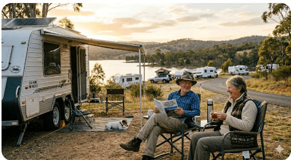
Why Grey Nomads Stop at Flat Rock
Flat Rock Campground near O’Connell draws grey nomads for a straightforward reason: it is genuinely free, it sits beside the Abercrombie River in a peaceful bush setting, and it provides a natural break point for travellers moving between Bathurst and the southern tablelands — including those heading toward Oberon, Jenolan Caves, Abercrombie Caves, and the Kanangra-Boyd National Park corridor.
For seniors travelling in caravans or motorhomes, the location fills a practical gap. Once you leave Bathurst heading south on the Abercrombie Road, there are very few formal stopping points before Oberon or beyond. Flat Rock provides a free overnight pause in a setting that is far more pleasant than a roadside rest bay — river sounds, birdlife, open skies, and stars that are genuinely dark without city light pollution.
The campground also appeals to grey nomads who prefer nature-based, no-crowds camping over busy powered caravan parks. By mid-morning on weekdays, the site often has only a handful of rigs — or none at all. On long weekends and school holidays, the site attracts more visitors including families and bushwalkers, so weekday arrivals are strongly preferred for seniors who value quiet.
First-hand observation: Arriving on a Tuesday afternoon in autumn, we counted just two other vehicles — one campervan and a solo traveller in a small tent. The river was running well, the trees were turning amber, and the flat rock shelf beside the water was a genuinely beautiful spot to sit and have afternoon tea. It felt a world away from the highway.
Free Camping — Know the Rules for Seniors
Flat Rock Campground is managed as a free campsite, however the exact land management arrangements have evolved. The campground sits within or adjacent to areas now classified under the NSW Centennial Catchments State Conservation Area framework, and some sections of the broader Abercrombie area fall under different management. This means rules can vary depending on the precise location of your campsite.
General Rules That Apply at Most NSW Free Campgrounds
- Maximum stay limits apply — typically 2 nights in most state-managed areas, but confirm locally.
- Generators: permitted during reasonable daylight hours only. Respect quiet hours (typically 9pm–7am).
- Campfires: subject to fire danger ratings and total fire bans — see full section below.
- Waste: no bins provided — carry out all rubbish.
- Dogs: check current rules — see pets section below.
- Camping outside designated camping areas is generally not permitted.
- No cutting of live timber or vegetation.
Quick Facts and Key Details 2026
| Detail | Information |
|---|---|
| Campground Name | Flat Rock Campground |
| Nearest Town | O’Connell, NSW (approx. 5km north) / Bathurst approx. 28km north |
| Postcode | 2795 |
| State | New South Wales, Australia |
| Road Access | Abercrombie Road — partially unsealed |
| GPS Coordinates | Approximately -33.640, 149.749 (see GPS section for detail) |
| Cost | Free (verify current status before travel) |
| Toilets | Pit/bush toilet on-site — basic |
| Water | No treated water on site — carry your own |
| Showers | None |
| Power | None |
| Mobile Signal | Limited — Telstra patchy in area |
| Campfires | Permitted in designated areas when not under fire ban |
| Caravan Access | Possible in dry conditions — see road section |
| Pets | Enquire with land manager — rules vary |
| Nearby Feature | Abercrombie River, flat rock shelf beside water |
| Distance to Oberon | Approximately 35km south via Abercrombie Road |
| Distance to Abercrombie Caves | Approximately 72km south of Bathurst |
How to Get There + GPS Coordinates
📍 GPS Coordinates — Flat Rock Campground
-33.640, 149.749 (approximate — verify with current mapping)
Coordinate source: Publicly available OpenStreetMap and Google Maps data. These coordinates place you in the general Flat Rock Campground area along the Abercrombie River near O’Connell.
⚠️ These coordinates are approximate. Use them as a starting guide and follow on-the-ground signage once you turn off the main road. Exact campground entry may vary by a few hundred metres.
Driving Directions from Bathurst (approx. 28km)
From the centre of Bathurst, head south on the Abercrombie Road (also signposted toward Oberon/Abercrombie Caves). Pass through the small community of O’Connell — you will see the O’Connell Post Office and church on your right, confirming you are on the correct route. Continue south on Abercrombie Road. Watch for signage directing you toward Flat Rock or the Abercrombie River camping area. The turnoff to the campground is accessed via an unsealed track that leads toward the river.
Driving Directions from Oberon (approx. 35km north)
From Oberon town centre, take Abercrombie Road heading north toward Bathurst. The Flat Rock Campground access track will be on your right (east side) as you approach the Abercrombie River crossing area. Watch your speed on the unsealed sections — the road narrows and has blind crests.
Caravan and Motorhome Access
In dry conditions, the access track to Flat Rock is passable for standard caravans and motorhomes — however this is not a sealed entry road. The track surface can become soft and slippery after rain, and is not recommended for large rigs in wet conditions. A standard 2WD vehicle with a caravan should manage the track in dry weather, but approach with caution and do not attempt the entry if the ground is visibly wet or soft.
From Sydney (approximately 210km west)
Take the Great Western Highway (A32) west from Sydney through Lithgow and Bathurst. From Bathurst, follow Abercrombie Road south as described above. Total drive time from Sydney is approximately 2.5–3 hours depending on traffic through the Blue Mountains.
From Orange (approximately 80km east)
From Orange, take the Mid Western Highway east to Bathurst, then follow Abercrombie Road south. Alternatively, use the Ophir Road / O’Connell Road route — check current conditions as some secondary roads in this region are unsealed and may be unsuitable after rain.
Road Conditions, Flooding and Unsealed Sections
Road Surface Summary
- Bathurst to O’Connell: Sealed bitumen — good condition.
- O’Connell to campground turnoff: Sealed with some sections of rough seal — manageable for caravans.
- Campground access track: Unsealed gravel/dirt — condition varies. Dry: manageable for standard caravans. Wet: 4WD recommended or avoid entirely.
Flooding Risk
The Abercrombie River is subject to flooding after heavy rainfall. The campground sits close to the river, which means the flat camping areas can flood or become waterlogged during and after significant rain events. The Central Tablelands of NSW is prone to sudden and intense rainfall, particularly in spring and autumn. If heavy rain is forecast, choose an alternative campground on higher ground.
Checking Road Conditions Before You Travel
Check the latest NSW road conditions before departing:
- LiveTraffic NSW — livetraffic.com — real-time road incidents and closures
- Bureau of Meteorology — bom.gov.au — rainfall and flood warnings for the Central Tablelands
- Call Bathurst Regional Council roads department for local road updates if the BOM is showing significant rainfall upstream.
Vehicle Suitability Summary
| Vehicle Type | Dry Conditions | Wet Conditions |
|---|---|---|
| 2WD sedan / SUV | ✅ Manageable | ⚠️ Use caution — avoid if very wet |
| Standard caravan + 2WD tow vehicle | ✅ Manageable with care | ❌ Not recommended |
| 4WD with caravan | ✅ Suitable | ⚠️ With caution |
| Motorhome (Class A / large) | ⚠️ Check access track width first | ❌ Avoid |
| Camper trailer (off-road) | ✅ Suitable | ⚠️ 4WD preferred |
| Large coach-style motorhome | ⚠️ Tight — turning may be difficult | ❌ Not recommended |
Remoteness and Senior Safety
O’Connell and the Abercrombie River area sit at approximately 900–950 metres above sea level on the Central Tablelands. This means the climate is genuinely different from coastal or lower-altitude NSW. Summers can be warm to hot during the day but nights cool down significantly. Winters are cold, with overnight temperatures regularly dropping below 5°C and occasionally below zero with frost.
Summer Considerations
- Daytime temperatures can reach 30–35°C in January and February.
- UV levels are high at altitude — shade your camp and apply sunscreen.
- Ensure you carry adequate water: at least 20 litres of drinking water per person beyond what you plan to use for cooking.
- Check Total Fire Ban status daily — campfires are prohibited during declared fire ban periods.
Winter Considerations
- Overnight temperatures below 5°C are common June through August.
- Frost on access tracks can make the unsealed section hazardous in early mornings.
- Ensure your rig has adequate insulation and heating — LPG heaters are popular among grey nomads in this region.
- Heavy wool or thermal sleeping setup is recommended if tent camping.
Wildlife — Birds, Reptiles and What to Watch For
The Abercrombie River area and surrounding bushland supports a rich array of wildlife typical of the Central Tablelands of NSW. This is one of the genuine pleasures of camping at Flat Rock — you are in functioning bushland with morning birdsong that a caravan park simply cannot replicate.
Birds
- Eastern Grey Kangaroo: Common in the valley at dawn and dusk. Keep food secured inside your van — they are not aggressive but will investigate food smells.
- Laughing Kookaburra: The morning alarm clock of Australian bush camping. Loud and reliable.
- Superb Fairy-wren: Often seen in the low scrub near the river flat.
- Sacred Kingfisher and Azure Kingfisher: Both species can be seen near the river — look for flashes of blue along the water’s edge.
- White-faced Heron: Often standing still in shallow river sections.
- Wedge-tailed Eagle: Regularly soars above the valley — look up on clear mornings.
Reptiles and Other Wildlife
- Eastern Brown Snake: Present in the region. Active in warm months. Do not disturb — this species is responsible for more snakebite fatalities in Australia than any other. Wear closed shoes, shake out boots before putting them on, and watch where you place your hands near rocks and logs.
- Red-bellied Black Snake: Often near water — give it space and it will move away.
- Blue-tongue Lizard: Slow-moving and harmless — commonly seen basking on flat rocks.
- Platypus: The Abercrombie River is known to support platypus. Your best chance of a sighting is at dawn or dusk in slow-moving, deeper sections of the river. Move slowly and quietly.
What Other Websites Don’t Tell You
Most camping directory websites list Flat Rock Campground with basic details — free, river setting, limited facilities. Here is what they typically leave out:
- The access track condition is the single biggest variable: Whether you can get your rig to the campground comfortably depends almost entirely on recent rainfall. Check BOM in the 48 hours before arrival.
- The flat rock shelf beside the river is genuinely spectacular: A large, smooth granite rock platform runs beside the Abercrombie River — it is the defining feature of the campground and the reason for its name. At low to medium river levels, you can walk along it, fish from it, and sit on it while watching the river. It is not well-documented in online listings.
- Weekends and long weekends attract a very different crowd: During school holidays and long weekends, the site can attract groups of four-wheel-drivers, trail bike riders using nearby tracks, and families — it becomes noticeably louder. If you want solitude, visit Tuesday to Thursday.
- No treated water on site: This is consistently under-reported. Carry all drinking water from Bathurst or Oberon. The river is not safe to drink without treatment.
- The toilet facility is basic: A pit toilet is available, but standards vary and it is not maintained to the same level as a national park camping area. Bring your own supplies.
- Rubbish collection does not occur on site: There are no bins. You must carry all rubbish out with you. This is non-negotiable and is part of responsible free camping etiquette.
- The competing website for this location (flatrocktentpark.com.au) is a separate, privately operated tent park — not the same free camping area. Check carefully which location you are booking or navigating to.
Best Time to Visit — Month-by-Month Breakdown
| Month | Conditions | Senior Rating | Notes |
|---|---|---|---|
| January | Hot days, cool nights | ⚠️ Moderate | Fire ban risk — check daily. UV high at altitude. |
| February | Hot, occasional storms | ⚠️ Moderate | Storm season — check BOM before travel. |
| March | Warm days, cooler nights — Autumn begins | ✅ Very Good | Excellent colours. River levels stabilising. |
| April | Mild and pleasant | ✅ Excellent | Best month overall. Low crowds mid-week. |
| May | Cool days, cold nights | ✅ Good | Quieter. Frost risk overnight — prepare your rig. |
| June | Cold — possible frost | ⚠️ Suitable with prep | Pack warm. River scenery beautiful. Very quiet. |
| July | Cold — frost likely overnight | ⚠️ Cold nights | Coldest month. Bring good heating. Very quiet. |
| August | Cold but improving | ⚠️ Suitable with prep | Track can be muddy from winter rain. |
| September | Spring — warming up | ✅ Good | Wildflowers. Wombats and kangaroos active. |
| October | Warm days, mild nights | ✅ Very Good | School holidays — busier on weekends. |
| November | Warm — fire season beginning | ✅ Good | Check fire restrictions. Beautiful green valley. |
| December | Hot — school holidays | ⚠️ Busy | Peak season. Arrive early or choose weekdays. |
For senior grey nomads, April, May and September to October represent the best balance of comfortable temperatures, manageable road conditions, and lower visitor numbers. Autumn in the Central Tablelands is particularly beautiful, with deciduous trees in O’Connell and Bathurst adding colour to the landscape.
Free and Low-Cost Camping Alternatives Nearby
- Chase Campground – South Bathurst
- The Orchard Campground – South Bathurst
- Chifley Dam Free Camping Area – The Lagoon
- McPhillamy Park (free outside events) – Mount Panorama
- Vittoria Rest Area – Mitchell Highway
- Robin Hill Rest Area – Bathurst
- Mount Lambie Rest Area – Great Western Hwy
- Billywillinga Rest Area – Mid-Western Highway
- Fitzgeralds Valley Rest Area – Mid-Western Highway
Abercrombie Caves Campground (Paid — National Parks)
Located approximately 72km south of Bathurst near the Abercrombie Caves Historic Site. Managed by NSW National Parks. Basic facilities including pit toilets and fire rings. Fee applies — check nationalparks.nsw.gov.au for current rates. This is a better-maintained alternative with more established facilities than Flat Rock.
Oberon Showground
Oberon Showground is approximately 35km south of Flat Rock via Abercrombie Road. It occasionally accepts overnight travellers by donation or low fee arrangement, though this is not guaranteed. Contact the Oberon Showground directly before relying on this option.
Dump Points Near O’Connell
There are no dump points at Flat Rock Campground. The nearest dump points for grey nomads are in Bathurst or Oberon. Always confirm current availability and operational status before travel.
| Location | Distance from Flat Rock | Notes |
|---|---|---|
| Bathurst Showground area / Council facilities | Approx. 28km north | Check current availability with Bathurst Regional Council |
| Oberon (Council or service station) | Approx. 35km south | Confirm with Oberon Shire Council — availability varies |
Water Sources Near the Campground
Where to Fill Your Water Tanks
- Bathurst: Multiple service stations and the Bathurst Visitor Information Centre at 1 Kendall Avenue provide access to town water. Fill tanks here before heading south.
- O’Connell: Very small community — do not rely on finding water here. It is primarily a rural residential area.
- Oberon: Town water available at Oberon. Confirm locations with Oberon Shire Council or use CamperMate to locate water access points.
Fuel Stops Along the Route
Fuel planning is important for this region. Once you leave Bathurst heading south on the Abercrombie Road, there are no fuel stations until you reach Oberon or return to Bathurst. Do not assume you can buy fuel at O’Connell — it is a small rural community without a service station.
| Location | Direction | Approx. Distance from Flat Rock | Fuel Types |
|---|---|---|---|
| Bathurst (multiple stations) | North via Abercrombie Rd | ~28km | ULP, Diesel, LPG at some stations |
| Oberon (service station/s) | South via Abercrombie Rd | ~35km | ULP, Diesel — confirm LPG availability |
| Lithgow (if heading east) | North-east via Bathurst | ~90km | Full range |
| Orange (if heading west) | West via Bathurst | ~95km | Full range |
Caravan Parks — Paid Alternatives Near O’Connell
If Flat Rock is not suitable — due to road conditions, weather, or your rig size — the following paid options provide more reliable facilities within a reasonable drive:
Bathurst (approx. 28km north)
Bathurst has several caravan parks and holiday parks offering powered sites, dump points, showers and laundry facilities. Bathurst is a full regional city with supermarkets, hospitals, fuel, and all services. For seniors who find the free camp too remote or the track too rough, Bathurst is the logical base with day trips to the Abercrombie area.
Oberon Caravan Park (approx. 35km south)
Oberon has caravan park facilities suitable for most rigs. Oberon township is a small but complete regional town with a supermarket, medical centre, hardware store and fuel. The surrounding area includes access to Jenolan Caves (approximately 35km west of Oberon) and the Kanangra-Boyd National Park.
Free campsites and powered sites fill fast during school holidays and peak season. If your preferred site is already gone, search remaining accommodation options below to explore the region.
Accommodation and flight search powered by Expedia. Booking through this search supports this website at no extra cost to you. As an affiliate, I earn from qualifying purchases at no extra cost to you.
Full Facilities Comparison Table
| Facility | Flat Rock (Free) | Abercrombie Caves Camp (Paid NP) | Bathurst Caravan Park | Oberon Caravan Park |
|---|---|---|---|---|
| Cost | Free | Paid (NP fee) | ~$35–$55/night | ~$35–$50/night |
| Toilets | Pit toilet | Pit toilet | Flushing | Flushing |
| Showers | None | None | Yes | Yes |
| Power | None | None | Yes (powered sites) | Yes (powered sites) |
| Treated Water | None — BYO | Verify on-site | Yes | Yes |
| Dump Point | None | None | Yes | Verify with park |
| River Access | Yes — excellent | Yes | No | No |
| Caravan Access | Dry conditions — manageable | Verify access | Yes — full access | Yes — full access |
| Campfires | Permitted (when not banned) | Permitted (when not banned) | Varies by park | Varies by park |
| Mobile Signal | Limited | Very limited | Yes — full coverage | Partial Telstra |
| Laundry | None | None | Yes | Yes |
| Wi-Fi | None | None | Some parks — verify | Verify with park |
Rates — All Options Near O’Connell 2026
| Location | Type | Approximate Rate 2026 | Notes |
|---|---|---|---|
| Flat Rock Campground | Free bush camp | $0 | Verify current status — may change |
| Abercrombie Caves Campground | National Park campground | Verify at nationalparks.nsw.gov.au | Fee applies — NP booking system |
| Oberon Caravan Park | Powered site | ~$35–$50/night (2 people) | Verify directly with park |
| Bathurst Caravan Parks | Powered site | ~$40–$55/night (2 people) | Multiple parks available — prices vary |
| Oberon Showground | Overnight — if available | Donation / low fee | Not guaranteed — contact showground |
Senior Safety Checklist — On and Off the Road
- Checked BOM weather and rainfall forecast for next 48 hours
- Checked LiveTraffic NSW for road incidents on Abercrombie Road
- Verified current fire danger rating and any Total Fire Ban in place
- Fuel tank filled in Bathurst before departing (next fuel is Oberon ~35km south)
- Minimum 20 litres of drinking water loaded — no potable water at camp
- Told a responsible person: destination, arrival date, and emergency contact plan
- PLB or satellite communicator charged and accessible — mobile signal is limited
- First aid kit checked and accessible
- Medications packed with enough supply plus 2-day buffer
- Snake bite pressure bandages in first aid kit
- Torch and spare batteries / headlamp accessible at night
- Rubbish bags packed — carry out all waste, no bins on site
- Vehicle and caravan tyres checked including spare
- Portable solar or battery power confirmed charged for CPAP or medical equipment
- Warm clothing packed — nights drop to 5°C or below in cool months
- Checked maximum stay limit with land manager — do not overstay
- Dump point planned on exit route — Bathurst or Oberon
- LPG bottles checked and sufficient supply for length of stay
What to Do Near O’Connell — Senior Activity Guide
Flat Rock Campground is not just a overnight stop — it is a base for exploring one of the most historically rich and scenically diverse regions of inland NSW. The Central Tablelands offers a surprising range of accessible experiences for senior travellers.
Abercrombie Caves Historic Site (approx. 72km south of Bathurst)
One of the largest natural limestone arch caves in the Southern Hemisphere. Guided tours available — suitable for seniors with reasonable mobility. The cave interior maintains a year-round temperature of approximately 17°C — bring a light jacket. Managed by NSW National Parks. Check nationalparks.nsw.gov.au for tour times and pricing.
Jenolan Caves (approx. 65km from Oberon — 100km from Flat Rock)
World-famous limestone cave system in the Blue Mountains ranges. Multiple cave tours available at different difficulty levels, including some designed for visitors with limited mobility. Book ahead — jenolancaves.org.au. Road access is steep and narrow on the final approach — large caravans must be left at Oberon or Hampton.
Bathurst City (approx. 28km north)
- Mount Panorama Circuit (free to drive outside event periods) — see McPhillamy Park guide
- Bathurst Regional Art Gallery — free entry, air-conditioned
- Australian Fossil and Mineral Museum — exceptional collection
- Ben Chifley’s Cottage — historically significant, easy walk
- Bathurst Farmers Markets (seasonal — check dates)
- Supermarkets, medical centre, chemist and all services in Bathurst city centre
Oberon and Surrounds (approx. 35km south)
- Oberon Museum — local history display
- Black Springs Reservoir and picnic area (scenic drive)
- Vulcan State Forest — forest drives, accessible in dry conditions
- Mayfield Garden (private garden — check seasonal opening) — internationally recognised cool-climate garden near Oberon
Fishing on the Abercrombie River
The Abercrombie River supports populations of brown trout and redfin perch. Fishing is popular from the flat rock shelf and river banks near the campground. A NSW recreational fishing licence is required for all freshwater fishing — purchase online at Service NSW before you leave Bathurst.
🗺️ Vanlife Savings Spots — GPS Coordinates and Postcodes
Use the interactive map below to find, save and share free camps, rest areas and overnight stops across Australia. Add Flat Rock and the surrounding stops as saved pins to build your own grey nomad route through the Bathurst and Central Tablelands region.
COPY PROMPT ➔ ASK AI ➔ SAVE TO FORM ➔ ADD SPOT PIN ➔ GET DIRECTIONS
📍 Interactive map — find free camps, rest areas and overnight stops near O’Connell and Bathurst. Enable location for best results.
| Stop Name | Approx. GPS | Postcode | Type | Wi-Fi Nearby |
|---|---|---|---|---|
| Flat Rock Campground | -33.640, 149.749 (approx.) | 2795 | Free bush camp | None on-site — Bathurst 28km |
| Vittoria Rest Area | See article | 2795 | Rest area | None |
| Robin Hill Rest Area | See article | 2795 | Rest area | None |
| Billywillinga Rest Area | See article | 2795 | Rest area | None |
| Chifley Dam Free Camp | See article | 2795 | Free camp | None |
| Bathurst (town centre) | -33.416, 149.577 | 2795 | Regional city | Yes — public library & cafes |
| Oberon (town centre) | -33.707, 149.861 | 2787 | Regional town | Limited — check locally |
Phone Signal and Emergency Communications
Mobile Coverage at Flat Rock Campground
Mobile phone coverage in the Abercrombie River valley near O’Connell is unreliable and often absent. Telstra provides the best rural coverage in this region, but even Telstra signal can drop out entirely in the valley floor near the river. Optus and Vodafone/TPG coverage is generally absent or very weak beyond Bathurst city in this direction.
Emergency Communication Options
- PLB (Personal Locator Beacon): Register at beacons.amsa.gov.au — free registration. Activating a PLB sends a distress signal to AMSA who coordinate rescue. This is the gold standard for remote area emergency communication.
- Satellite Communicator (Garmin inReach, SPOT): Two-way messaging via satellite — useful for non-emergency contact with family and for tracking. Subscription required.
- HF Radio: Some experienced grey nomads carry HF transceivers for outback travel — less relevant for this region but useful if you are undertaking longer remote journeys.
- Telstra signal (elevated ground): Walking or driving to higher ground on the Abercrombie Road can sometimes restore a signal. Test this on arrival to know your emergency options.
Nearest Emergency Services
- Police: Bathurst Police Station — (02) 6338 0999 (approximately 28km north)
- Hospital: Bathurst Base Hospital — 143 Howick Street, Bathurst — (02) 6330 5311
- Ambulance: Triple Zero (000) — response time to remote areas may be extended
- SES (State Emergency Service): 132 500 — for flood, storm or tree damage emergencies
Campfires, Cooking Restrictions and Food Near O’Connell
Campfire Rules at Flat Rock Campground
Campfires are generally permitted at Flat Rock Campground in designated fire areas when conditions allow. However, this is subject to:
- Total Fire Bans: Declared by the NSW Rural Fire Service during high fire danger periods. All campfires (including gas and solid fuel) are banned during a Total Fire Ban. Check NSW RFS (rfs.nsw.gov.au) before and during your stay.
- Fire Danger Ratings: Even below Total Fire Ban, exercise extreme caution on days rated Extreme or above.
- Land manager rules: The specific campground may have additional fire restrictions — check with the relevant manager before travel.
Gas Cooking
Portable gas stoves and camp ovens are the most reliable cooking option at Flat Rock. Gas cooking is permitted even on Total Fire Ban days in most circumstances (check the specific ban declaration — some high-level bans may include gas). LPG and butane stoves are preferred by most grey nomads in this region for convenience and weather reliability.
Food Purchases Near O’Connell
- O’Connell: No supermarket or food outlet — very small rural community.
- Bathurst (28km north): Full supermarket range — Woolworths, Coles, and IGA. Farmers markets seasonal — check local events calendar. Multiple cafes and restaurants in the city centre.
- Oberon (35km south): IGA supermarket, bakery, and several cafes. Smaller range than Bathurst but adequate for resupply.
Pets at Flat Rock Campground
Pet rules at free camps on state land in NSW depend on the specific management arrangements. Generally speaking:
- Pets are permitted at many Crown Lands and State Forest free camping areas with the expectation that they are kept under control and on a leash.
- If the campground or adjacent land has been incorporated into a National Park or State Conservation Area, stricter rules may apply and pets may be prohibited.
- Always check the current rules with the relevant land manager before travelling with a pet.
Accessibility for Seniors with Mobility Limitations
Flat Rock Campground is a natural bush camping area and is not purpose-built for accessibility. Seniors with mobility limitations should assess the following before committing to this site:
- Access track: The unsealed entry track may be uneven and bumpy — this can be uncomfortable for seniors with back or hip conditions, even in a vehicle.
- Campground surface: The camping area is on natural ground — grass, soil and river flat. It is not level in all areas. Bring levelling blocks.
- Toilet facility: A pit toilet is available, but it is a basic structure without grab rails or disability access. Seniors with significant mobility limitations may find this challenging — bring a portable toilet and privacy tent as a backup.
- The flat rock shelf: Access to the rock platform beside the river involves some uneven terrain. Seniors with walking aids should assess this carefully — the rock surface can be slippery when wet.
- Medical access: The nearest hospital is in Bathurst (28km north). In a medical emergency, response time will be extended due to the remote location and limited mobile signal for calling triple zero.
Permits, Fees, Etiquette and Waste Management
Permits and Fees
As of the time of writing, Flat Rock Campground is a free campsite with no formal permit required. However, land management arrangements in this region have evolved and a fee or booking system may be introduced. Always verify current status at nationalparks.nsw.gov.au or with the relevant land manager before travel.
Camping Etiquette for Grey Nomads
- Carry out all rubbish: No bins on site. Pack enough rubbish bags for your entire stay.
- Respect quiet hours: Generators off after 9pm. Keep noise levels considerate, particularly near other campers.
- Country gate rules: If you encounter a gate on access tracks — leave it as you found it. Open gate = leave open. Closed gate = close after you. Locked gate = do not enter.
- No cutting of live trees or branches: Bring your own firewood from Bathurst or Oberon if you plan a campfire. Collecting wood from the bush removes habitat for native wildlife.
- Human waste: Use the pit toilet provided. If it is unavailable, bury human waste in a cat hole at least 15cm deep, a minimum of 50 metres from the river, tracks and campsites. Carry a trowel.
- Grey water: Do not discharge grey water directly to the river or its banks. Use a grey water containment system or discharge well away from the water course.
- Respect wildlife: Do not feed animals. Feeding wildlife — including kangaroos — disrupts natural behaviour and can cause long-term harm.
Waste Management and Dump Points
See the Dump Points section above. The nearest dump points are in Bathurst or Oberon. Plan your exit route around a dump point stop — do not discharge black water to the environment.
Emergency Scenarios — What to Do
Medical Emergency
- Attempt Triple Zero (000) — if no signal, move to higher ground on Abercrombie Road to find signal.
- If no signal available: activate PLB immediately. AMSA will coordinate response.
- Apply first aid appropriate to the emergency while waiting for help.
- Send another person to Bathurst (28km north) to contact emergency services if PLB is unavailable.
- Nearest hospital: Bathurst Base Hospital — 143 Howick Street, Bathurst, (02) 6330 5311.
Vehicle Breakdown or Bogging
- Stay with your vehicle — do not attempt to walk to Bathurst.
- Display distress signal (orange flag, headlights on, horn).
- Attempt roadside assistance contact: NRMA (132 132) when signal available.
- If no signal: PLB activation is appropriate for a serious breakdown in a remote location.
- Carry basic recovery gear: traction boards, tow strap, shovel — particularly useful on wet access tracks.
Flash Flooding
- If river levels begin rising, move your rig immediately to higher ground — do not wait.
- Never attempt to drive through floodwater — even 30cm of fast-moving water can move a vehicle.
- Contact SES on 132 500 when signal allows.
- If trapped by flooding: stay in your vehicle on high ground, activate PLB if in danger.
Bushfire
- Monitor fire danger ratings and RFS alerts at rfs.nsw.gov.au daily.
- If fire is threatening: leave immediately via the clearest route. Do not wait for the fire to be visible — leave on a Catastrophic or Extreme fire danger day if conditions deteriorate.
- Your survival plan should be: leave early, never late.
- Carry the Fires Near Me app on your phone — check it before camping in fire season.
Packing List for the Abercrombie Road / O’Connell Region
Water and Food
- Minimum 20 litres drinking water per person for 2-night stay
- 3-day food supply purchased in Bathurst before departure
- Gas stove and sufficient LPG/butane for cooking and hot drinks
- Portable camp kettle or billy
- Water filter (for washing water from river — not for drinking without additional treatment)
Safety and Communication
- PLB (registered with AMSA) — fully charged
- First aid kit including pressure immobilisation bandages for snakebite
- Fire extinguisher accessible in vehicle
- Torch and spare batteries / headlamp
- Physical paper map or downloaded offline map for Abercrombie Road area
- Satellite communicator (optional but recommended for seniors)
Camp Setup
- Levelling blocks (ground at camp is uneven)
- Rubbish bags — minimum 4 bags for a 2-night stay
- Grey water containment system
- Portable toilet and privacy tent (if the pit toilet is unavailable or unsuitable)
- Firewood (purchased in Bathurst — do not collect from the bush)
- Firestarter and matches / lighter
- Bucket of water beside campfire at all times
Clothing and Comfort
- Warm thermal layers for evening and night — temperatures drop sharply after dark
- Waterproof jacket — weather can change quickly on the tablelands
- Closed-toe shoes or boots — essential for snake safety in warm months
- Hat, sunglasses and sunscreen SPF50+ — UV is high at altitude
- Camp chair with good back support — for river-side relaxation
- Binoculars — for birdwatching and wildlife spotting from camp
5 Rest Areas Near O’Connell / Bathurst
| Rest Area / Camp | Direction from Flat Rock | Approx. Distance | Key Features |
|---|---|---|---|
| Vittoria Rest Area | North-west via Bathurst — Mitchell Hwy | ~40km from Flat Rock | Rest area on Mitchell Highway — basic facilities |
| Robin Hill Rest Area | North via Bathurst | ~30km from Flat Rock | Rest area near Bathurst — suitable overnight stop |
| Mount Lambie Rest Area | North-east via Bathurst — Great Western Hwy | ~55km from Flat Rock | Great Western Highway rest area |
| Billywillinga Rest Area | South-west via Bathurst — Mid-Western Hwy | ~50km from Flat Rock | Mid-Western Highway — suitable for caravans |
| Chifley Dam Free Camping Area | North-east of Bathurst | ~45km from Flat Rock | Free camping near Chifley Dam — scenic setting |
Reviews — What Grey Nomads Say About Flat Rock
“One of the better free stops in the region — the flat rock beside the river is exactly as the name describes. We spent two nights here in April and had the place almost entirely to ourselves Monday and Tuesday. The access track was fine for our 18-foot caravan in dry conditions. Carry your water from Bathurst — there’s nothing on site.”
“Lovely bush setting and a beautiful river. The pit toilet was functional but basic — bring your own supplies. We saw a blue-tongue lizard on the first morning and heard kookaburras constantly. The Telstra signal was non-existent at camp but we found one bar if we drove back up to the main road. Four stars — take one off for the lack of water and the rough last section of track.”
“We arrived after two days of rain and the access track was slippery clay. We decided not to risk it with the caravan and camped at a rest area near Bathurst instead. Came back three days later in dry conditions and it was perfect. The location is beautiful — just check the weather first.”
Note: Reviews are sourced from publicly available grey nomad travel forums and camping community comments. Individual experiences may vary. Always verify current conditions directly before travel.
Frequently Asked Questions
Is Flat Rock Campground really free?
As of 2026, Flat Rock Campground near O’Connell is understood to be a free camping area. However, land management in this region has changed over recent years and a fee or booking system may be introduced. Always verify current status with NSW National Parks or the relevant land manager before travelling.
Can I get my caravan to Flat Rock Campground?
In dry conditions, a standard caravan and 2WD tow vehicle can typically access the campground via the Abercrombie Road and access track. In wet conditions, the unsealed track becomes slippery and is not recommended for caravans. Very large rigs (over 8–9m) may find turning space tight near the campground. Always assess conditions on the day.
Is there water at Flat Rock Campground?
No. There is no treated potable water at the campground. Carry all drinking water from Bathurst or Oberon before arriving. The Abercrombie River is not safe to drink without proper treatment.
Does the road to Flat Rock flood?
Yes. The Abercrombie River and surrounding flats are subject to flooding after heavy rainfall. The access track can also become impassable in wet conditions. Always check the BOM forecast and LiveTraffic NSW before departing, and never camp on the river flat if rain is forecast upstream.
Is there mobile signal at Flat Rock Campground?
Mobile signal is limited and often absent at the campground, even on the Telstra network. Do not rely on your phone for emergency contact. Carry a registered PLB or satellite communicator.
Can I have a campfire at Flat Rock?
Campfires are generally permitted when conditions allow and no Total Fire Ban is in force. Check the NSW RFS website and current fire danger ratings before your trip. Always extinguish fires completely with water before sleeping or leaving camp.
Are there toilets at Flat Rock?
A basic pit toilet is available on site. It is not maintained to national park standards and is not accessible for seniors with significant mobility limitations. Bring your own supplies and consider a portable toilet as a backup.
How far is Flat Rock from Bathurst?
Approximately 28 kilometres south of Bathurst city centre via Abercrombie Road. Drive time is approximately 30–40 minutes depending on road conditions.
Can I take my dog to Flat Rock Campground?
Pet rules depend on the current land management classification. Generally permitted on a leash at many NSW free camps, but verify with the relevant manager. Keep dogs leashed at all times near the river to protect native wildlife including platypus.
What is the best time of year to visit Flat Rock?
April to May (Autumn) and September to October (Spring) offer the best combination of mild temperatures, manageable road conditions, and lower visitor numbers. Avoid January to February (heat and fire risk) and very wet periods (flooding and track access issues).
Quick-Reference Card
📋 Flat Rock Campground — Quick Reference
| Location | Near O’Connell, NSW 2795 — approx. 28km south of Bathurst via Abercrombie Road |
| GPS (approx.) | -33.640, 149.749 — verify with current mapping before travel |
| Cost | Free — verify current status before travel |
| Road Access | Sealed to O’Connell — unsealed access track to camp. Dry conditions only for caravans. |
| Flood Risk | Yes — Abercrombie River floods. Check BOM before travel. |
| Toilets | Basic pit toilet on site |
| Water | None — carry all drinking water from Bathurst or Oberon |
| Power | None |
| Dump Point | Bathurst (~28km) or Oberon (~35km) |
| Fuel (North) | Bathurst — approx. 28km |
| Fuel (South) | Oberon — approx. 35km |
| Mobile Signal | Very limited — Telstra only, often absent at camp |
| Emergency | PLB essential — nearest hospital Bathurst Base (02) 6330 5311 |
| Best Months | April–May, September–October |
| Campfires | Permitted when not under Total Fire Ban — check RFS daily |
| Road Conditions | LiveTraffic NSW: livetraffic.com | Weather: bom.gov.au |
| NP Info | nationalparks.nsw.gov.au | 1300 072 757 |
Travelling solo or leaving your rig unattended at camp?
Exclusive Offer: Get 5% OFF all StarterStopper immobiliser products with promo code: RTV5
Visit StarterStopper.com to see data-backed vehicle security solutions
As an affiliate, I earn from qualifying purchases at no extra cost to you.
Travelling from the USA? RV LIFE Trip Wizard is a USA-Based RV Trip Planning Tool
If you are visiting Australia from the United States and planning your North American RV trips, RV LIFE Trip Wizard is a popular USA-focused route planning platform for RVers. Please note this tool is designed for USA road networks and is not applicable for Australian travel planning.

As an affiliate, I earn from qualifying purchases at no extra cost to you.
Disclaimer
Accuracy Notice: The information in this article is compiled from publicly available sources including NSW National Parks and Wildlife Service, NSW Government mapping data, OpenStreetMap, Google Maps, and grey nomad community travel forums. While every effort has been made to ensure accuracy at the time of writing (June 2026), road conditions, campground access, management arrangements, fees, and facilities can change without notice.
GPS Coordinates: Coordinates provided are approximate and sourced from publicly available mapping data. They are provided as a navigation guide only and should be verified against current official maps and on-the-ground signage. Do not rely solely on GPS in areas with limited mobile coverage.
Medical and Emergency Information: Phone numbers, hospital locations and emergency service details are provided in good faith but may change. Always verify current emergency contact details before travelling to remote areas.
Affiliate Disclosure: This article contains affiliate links to Expedia, StarterStopper, and RV LIFE Trip Wizard. If you make a purchase through these links, RetireToVanLife.com earns a small commission at no additional cost to you. This income helps support the production of free travel guides for senior grey nomads.
Not Professional Advice: This article does not constitute professional legal, medical, financial or safety advice. Always consult relevant authorities and professionals for decisions affecting your health, safety and finances.
© 2026 RetireToVanLife.com — Information correct to the best of our knowledge at time of publication. Verify all details before travel.
© 2026 RetireToVanLife.com — All rights reserved. Written for Senior Grey Nomads. Safe travels. 🚐