Belyando River Rest Area — Free Camping Senior Grey Nomad Guide 2026
Is the Belyando River Rest Area a safe, comfortable overnight stop for grey nomads towing caravans through central Queensland in 2026 — or should you push on to a powered site? Here is the full honest guide.
📋 Table of Contents
- Belyando River Rest Area and the Central Queensland Corridor: Why Grey Nomads Stop Here
- The Free Camp Temptation — Here Is the Truth for Seniors
- Your Two Main Options Side by Side
- Belyando River Rest Area: Full Facilities, GPS and Access Details
- Is a Permit or Fee Required at Belyando River Rest Area?
- What Belyando River Rest Area Doesn’t Tell You Online
- Van Life Savings Spots — Free and Low-Cost Camping Near Belyando Crossing
- Dump Points on Your Route — GPS Before and After Belyando River
- Free Potable Water Locations — GPS Before and After Belyando River
- Clermont as Your Alternative Base: The Smarter Senior Option
- Full Facilities Comparison: Belyando River Rest Area vs Clermont vs Charters Towers
- Rates: All Options Near Belyando Crossing
- The Belyando Crossing Day Plan for Seniors
- Senior Checklist — Belyando River Rest Area Stop
- What to Do Near Belyando Crossing: Your Senior Day Plan
- GPS Coordinates and Postcodes: Save Every Stop
- Frequently Asked Questions — Belyando River Rest Area for Grey Nomads
- Quick-Reference Card + Booking Options
- Fuel Station Distances — North, South, East and West of Belyando River Rest Area
- Road Conditions, Flooding and Access — Getting to Belyando River Rest Area
1. Belyando River Rest Area and the Central Queensland Corridor: Why Grey Nomads Stop Here
The Belyando River Rest Area sits on the Gregory Developmental Road (also known as the Gregory Highway) in central Queensland, roughly halfway between Clermont and Charters Towers. It is one of the most popular free overnight stops on this inland corridor, and for good reason — the Belyando River Rest Area offers shade trees along the riverbank, basic facilities, and a peaceful spot to break a long driving day across Queensland’s interior.
For grey nomads travelling the inland route between Emerald and Charters Towers in 2026, the Belyando River Rest Area is often the logical place to pull over for the night. The distance between Clermont and Charters Towers is approximately 290 km of largely empty road, with very limited services in between. The Belyando Crossing — where the Gregory Developmental Road crosses the Belyando River — is roughly 110 km north of Clermont and about 180 km south of Charters Towers.
The rest area is situated on the southern side of the Belyando River bridge. It is managed by the Queensland Department of Transport and Main Roads as a designated rest area where overnight camping is permitted for self-contained travellers. This is not a national park, not a council campground, and not a caravan park — it is a roadside rest area with basic amenities.
2. The Free Camp at Belyando River — Tempting, But Here Is the Truth for Seniors
The Belyando River Rest Area looks fantastic in photos. You will see images of caravans parked under large eucalyptus trees beside a sandy riverbed, with campfire stories and peaceful sunsets. For many travellers, that is exactly what it delivers. But for seniors — particularly those over 70, solo women, or anyone with medical equipment — there are real considerations that online reviews rarely mention.
- No mains power (240V): CPAP users must carry a lithium battery or a quiet generator. There is no power at this rest area.
- Phone signal is patchy: Telstra coverage at the Belyando Crossing is unreliable. You may get intermittent signal but cannot depend on it for an emergency call. Optus coverage is generally absent.
- Nearest hospital is 110+ km away: Clermont Multi-Purpose Health Service is the closest hospital. In a medical emergency at night, you are a long way from help.
- Insects can be severe: Mosquitoes along the Belyando River can be ferocious, particularly after wet season rain or if there is standing water. Midges are also present at dusk and dawn.
- Road trains use the highway at night: The Gregory Developmental Road carries road train traffic. If you are a light sleeper, the noise of trucks crossing the bridge may disturb you.
- Flooding risk: The Belyando River floods regularly during the wet season (November–March). The rest area and the road itself can become inaccessible for days or weeks after significant rain.
None of these issues mean you should avoid the Belyando River Rest Area entirely — it is a legitimate, well-used free camp. But if you are a senior who relies on powered medical equipment, or you are travelling solo and value phone connectivity for safety, you need to plan around these realities rather than discovering them at 9 pm in the dark.
3. Your Two Main Options Side by Side — Belyando River Rest Area vs Clermont Caravan Park
| Feature | Belyando River Rest Area (Free) | Clermont Caravan Park (Paid) |
|---|---|---|
| Cost | ✅ Free | 💲 From ~$35–$45/night powered (confirm direct) |
| 240V Power | ❌ No | ✅ Yes — powered sites |
| Toilets | ✅ Pit toilet | ✅ Flush toilets + hot showers |
| Showers | ❌ No | ✅ Yes |
| Drinking Water | ❌ No — bring your own | ✅ Yes — town supply |
| Dump Point | ❌ No | ✅ Yes — on-site or in town |
| Big Rigs | ✅ Yes — large area, easy access | ✅ Yes — drive-through available |
| Telstra Signal | ⚠️ Patchy — unreliable | ✅ Good — in town |
| Pets | ✅ Yes | ✅ Yes — check on booking |
| Hospital Distance | ⚠️ ~110 km to Clermont | ✅ In town — walking distance |
| Fuel Available | ❌ No | ✅ Yes — in town |
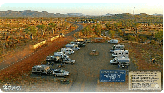
4. Belyando River Rest Area: Full Facilities, GPS and Access Details
| 📍 Belyando River Rest Area — Quick Facts 2026 | |
|---|---|
| Full Name | Belyando River Rest Area (Belyando Crossing) |
| Location | Gregory Developmental Road, approximately 110 km north of Clermont, QLD |
| GPS | -21.7917, 147.0217 (approx — verify in Google Maps before departure) |
| Postcode | 4721 |
| Cost | Free |
| Stay Limit | 20 hours (confirm with signage on arrival — Queensland rest areas typically permit up to 20 hours) |
| Road Access | Sealed — Gregory Developmental Road is sealed at the crossing. The turn-off into the rest area is a short unsealed/gravel section. |
| Caravans | ✅ Yes — suitable for caravans |
| Big Rigs | ✅ Yes — large open area with room for big rigs to park and turn |
| Toilets | ✅ Pit/drop toilet on-site |
| Drinking Water | ❌ No — bring your own. No potable water supply. |
| Mains Power (240V) | ❌ No — CPAP battery or generator needed |
| Telstra Reception | ⚠️ Patchy — some users report intermittent 4G, others report nothing. Do not rely on phone signal here. |
| Optus Reception | ❌ Generally no coverage |
| Pets | ✅ Allowed |
| Dump Point | ❌ No on-site dump point. Nearest: Clermont ~110 km south or Charters Towers ~180 km north |
| Fires | ⚠️ Campfires may be permitted in designated fire rings — check fire bans on arrival. Total fire bans are common in dry season. |
| Tables/Shelters | ✅ Picnic tables present. Some shade from established trees. |
| Nearest Hospital | ⛑️ Clermont Multi-Purpose Health Service — ~110 km south | (07) 4983 0100 |
| Senior Rating | ⭐⭐⭐ — Good free stop for self-contained travellers, but remote with no power, no water, and unreliable phone signal. CPAP users and solo travellers should carefully weigh the risks. |
The rest area is on the southern side of the Belyando River bridge. You will see signage on the Gregory Developmental Road indicating the rest area. The turn-off is a short gravel track leading down to a large flat area under trees along the riverbank. The surface is a mix of compacted earth and gravel — generally firm in dry conditions but can become muddy after rain.
There is ample room for multiple caravans, motorhomes, and big rigs. Drive-through access is available for most of the parking area, meaning you do not need to reverse a large rig. However, specific spots closer to the river may require some manoeuvring.
5. Is a Permit or Fee Required at Belyando River Rest Area?
No. The Belyando River Rest Area is a free roadside rest area managed by Queensland Department of Transport and Main Roads. No permit is required, no booking is needed, and there is no fee. You simply pull in and park.
The standard Queensland rest area stay limit applies — typically 20 hours. This is designed to allow an overnight rest before continuing your journey. This is not a long-term camping spot. Signage on-site will confirm the current stay limit in 2026.
No national parks pass is required. The rest area is not within a national park or state forest.
6. What Belyando River Rest Area Doesn’t Tell You Online
Here are the things that experienced travellers know but online reviews rarely mention. These are based on common reports from grey nomads who have stayed at the Belyando River Rest Area:
Mosquitoes Can Be Brutal
The Belyando River is a seasonal waterway. After wet season rains, pools of standing water remain in the riverbed and surrounding areas. These breed mosquitoes. From late wet season (February–April) and even into early dry season, the mosquito population at this rest area can be severe. Carry insect repellent, mosquito coils, and ensure your van’s screens are in good condition. If you have an awning, a mesh screen enclosure is highly recommended.
The Toilet May Not Be Well-Maintained
As with many remote Queensland rest areas, the pit toilet is serviced periodically but not daily. Conditions vary depending on how recently it has been cleaned and how many travellers have passed through. Carry your own toilet paper and hand sanitiser. Some grey nomads report the toilet being in poor condition during peak season.
Cattle May Be Present
The surrounding properties are working cattle stations. It is not uncommon for cattle to wander near or through the rest area, particularly if the river has water in it. Keep your food stored securely and be mindful of cattle when walking dogs.
Phone Signal Is Genuinely Unreliable
Despite some coverage maps suggesting marginal Telstra signal, many travellers report no usable data connection at the Belyando Crossing. A few report getting enough signal for a phone call on higher ground. Do not plan to rely on mobile internet or emergency calls from this location.
CPAP Users — Plan Your Power Carefully
There is no mains power at the Belyando River Rest Area. If you use a CPAP machine, you need a fully charged lithium battery (such as a Medistrom Pilot-24 Lite or EcoFlow River) that will last the full night. Alternatively, some grey nomads run a quiet inverter generator, but be courteous to other campers — the rest area is otherwise very quiet at night. If your battery power situation is uncertain, it may be wiser to continue to Clermont or Charters Towers for a powered site. For more on preparing your caravan’s electrical system for remote travel, see our caravan maintenance guide for grey nomads.
Road Conditions, Flooding and Access — Getting to Belyando River Rest Area in Any Vehicle
Understanding the road to the Belyando River Rest Area is critical for grey nomads, especially those towing caravans or driving large motorhomes. Here is the full picture for 2026.
The Gregory Developmental Road — Is It Sealed?
The Gregory Developmental Road between Clermont and Charters Towers is sealed for most of its length, but the seal quality varies considerably. Some sections are smooth and well-maintained. Other sections — particularly between Belyando Crossing and the northern end closer to Charters Towers — can be rough, with patchy bitumen, potholes, and narrow sections with no road shoulders.
The road is single-lane in each direction with no centre divider. Road trains use this route, and passing them requires you to slow down and pull as far left as safely possible. Dust can be an issue when road trains pass, particularly on sections where the shoulder is unsealed.
Does the Road Flood?
- The Belyando River and its tributaries flood regularly during the wet season (typically November to March). The river crossing and the road approaches can become impassable after heavy rainfall.
- The Gregory Developmental Road has multiple creek and river crossings between Clermont and Charters Towers that are all subject to flooding. Even if the Belyando Crossing itself is clear, other crossings on the route may be flooded.
- Road closures can last from a few hours to several weeks depending on the severity of the flooding.
- Never cross a flooded road or bridge. “If it’s flooded, forget it” — this is not optional advice, it is Queensland law under the Transport Operations (Road Use Management) Act.
- Check QLDTraffic.qld.gov.au or call 13 19 40 for real-time road condition reports before departing.
The Rest Area Access Track
The turn-off from the Gregory Developmental Road into the Belyando River Rest Area itself is a short unsealed/gravel track — typically only 50–100 metres. In dry conditions, this is firm and suitable for any vehicle including caravans and motorhomes. After rain, however, this gravel section can become soft and muddy. A 2WD vehicle with a caravan may struggle if the ground is saturated.
Coming from the South (Clermont / Emerald Direction)
From Clermont, head north on the Gregory Developmental Road. The road is sealed. You will travel approximately 110 km through largely flat to gently undulating cattle country. There are no towns, no fuel stops, and no services between Clermont and the Belyando Crossing. The road passes through several creek crossings that may flood in wet season.
Coming from the North (Charters Towers Direction)
From Charters Towers, head south on the Gregory Developmental Road. The distance to the Belyando Crossing is approximately 180 km. Again, the road is sealed but quality varies. There are no services between Charters Towers and the Belyando Crossing — no fuel, no water, no shops.
Coming from the East (Mackay Direction)
If you are travelling from Mackay on the coast, you would typically head inland via the Peak Downs Highway to Clermont (approximately 270 km from Mackay, all sealed), then continue north on the Gregory Developmental Road to the Belyando Crossing. The Peak Downs Highway is a well-maintained sealed highway suitable for all vehicles.
Coming from the West (Longreach / Emerald Direction)
From Emerald, take the Capricorn Highway east briefly then the Gregory Highway north through Clermont. Emerald to Clermont is approximately 110 km on a sealed highway. From Longreach, you would travel east on the Capricorn Highway to Emerald (~680 km, all sealed) then north to Clermont and on to the Belyando Crossing.
Fuel Station Distances — North, South, East and West of Belyando River Rest Area
Fuel planning is critical on this route. There are no fuel stations between Clermont and Charters Towers — that is approximately 290 km with zero fuel availability. The Belyando River Rest Area sits roughly in the middle of this fuel desert. Here are your nearest fuel options in every direction:
| Direction | Nearest Fuel Station | Approx. Distance | Notes |
|---|---|---|---|
| South — Clermont | Clermont fuel stations (multiple — BP, Caltex/Ampol, independent) | ~110 km | Last fuel heading north. Fill up completely before leaving Clermont. |
| North — Charters Towers | Charters Towers fuel stations (multiple — BP, Caltex/Ampol, Shell, independent) | ~180 km | First fuel heading north. Major town with all services. |
| East — Mackay (via Clermont) | Clermont fuel stations | ~110 km to Clermont, then ~270 km to Mackay | Must go via Clermont first. Multiple fuel stops between Clermont and Mackay on Peak Downs Highway. |
| West — Emerald (via Clermont) | Clermont fuel stations | ~110 km to Clermont, then ~110 km to Emerald | Must go via Clermont first. Emerald has full services. |
- 290 km between fuel stations (Clermont to Charters Towers). If you are towing a caravan, your fuel consumption will be significantly higher than unladen driving. A vehicle towing a large van may consume 18–25+ litres per 100 km on this road.
- Fill your tank completely at Clermont or Charters Towers — whichever direction you are coming from.
- Carry at least 20 litres of spare fuel in an approved jerry can if your vehicle’s range is marginal.
- Running out of fuel on the Gregory Developmental Road means a very long wait. Roadside assistance response times in this area can be many hours.
COPY PROMPT ➔ ASK AI ➔ SAVE TO FORM ➔ ADD SPOT PIN ➔ GET DIRECTIONS
📍 Interactive map — find free camps, rest areas and overnight stops. Enable location for best results.
7. Van Life Savings Spots — Free and Low-Cost Camping Near Belyando Crossing
If the Belyando River Rest Area is full or does not suit your needs, there are alternatives on this route — though they are limited given the remoteness of this corridor. For the full Queensland free camp database — including the ability to ask the AI for GPS to nearby attractions, alternative accommodation, or the next free camp on your route — visit our Van Life Savings Spots App. It is built specifically for senior grey nomads and lets you ask questions like “what is the nearest dump point to Belyando Crossing?” or “find me powered sites near Clermont tonight” and get back GPS coordinates instantly.
- “Find free camps between Clermont and Charters Towers with toilets”
- “Where is the nearest powered site to Belyando Crossing QLD?”
- “What is the nearest dump point north of Clermont on the Gregory Highway?”
- “Show me free camping near Charters Towers with big rig access”
| Camp Name | Distance from Belyando | Cost | Senior Notes |
|---|---|---|---|
| Clermont Showgrounds | ~110 km south | Low cost (confirm with Isaac Regional Council) | Power available, toilets, showers, town water. In town with hospital access. Pet-friendly. GPS: -22.8243, 147.6396 (approx) |
| Mingela Rest Area | ~145 km north (on Flinders Highway east of Charters Towers) | Free | Basic rest area. Toilet. No water or power. On route to Townsville. GPS: -19.8800, 146.6100 (approx — verify) |
| Charters Towers Showgrounds / Free Camps | ~180 km north | Free–Low cost | Charters Towers has multiple options including low-cost showground camping and free camps in the area. Full town services, hospital, fuel. GPS: -20.0767, 146.2625 (approx — town centre) |
For more free and low-cost camp options across Queensland, visit our Van Life Savings Spots page.
7b. Dump Points on Your Route — GPS Before and After Belyando River Rest Area
| Location | Direction | Distance | GPS / Details |
|---|---|---|---|
| Clermont Dump Point | South (before if heading north) | ~110 km | Clermont, QLD 4721. Located near the Clermont Showgrounds area. GPS: -22.8243, 147.6396 (approx — verify via toiletmap.gov.au or WikiCamps). Free. |
| Belyando River Rest Area | On-site | — | ❌ No dump point on-site. |
| Charters Towers Dump Point | North (after if heading north) | ~180 km | Charters Towers, QLD 4820. Multiple dump point locations in town — confirm via Charters Towers Regional Council or WikiCamps. GPS: -20.0767, 146.2625 (approx — town centre). Free. |
- Never use a dump point rinse hose for drinking water. The hose at a dump point is for rinsing waste connections only.
- If you have a cassette toilet, allow extra time at busy dump points — especially during peak season when multiple vans may be queuing.
- With no dump point between Clermont and Charters Towers, ensure your waste tanks have sufficient capacity for the full 290 km journey. If not, use the dump point in Clermont or Charters Towers before heading into this section.
7c. Free Potable Water Locations — GPS Before and After Belyando River Rest Area
| Location | Direction | Distance | Water Status |
|---|---|---|---|
| Belyando River Rest Area | On-site | — | ❌ No potable water. Do not drink river water. |
| Clermont | South | ~110 km | ✅ Town water supply. Fill up at caravan park, showgrounds, or public taps in town. GPS: -22.8243, 147.6396 (approx — town) |
| Charters Towers | North | ~180 km | ✅ Town water supply. Multiple locations to fill up. GPS: -20.0767, 146.2625 (approx — town centre) |
- There is no potable water between Clermont and Charters Towers — a distance of 290 km. Carry at least two full days of emergency drinking water reserves beyond your planned daily use.
- Never fill from an unmarked tap. Dam, creek, or river water must not be used for drinking — even if boiled — unless you have a certified water filtration system.
- In hot weather (common in this region even outside summer), your water consumption will be significantly higher. Budget at least 3–4 litres per person per day minimum.
8. Clermont as Your Alternative Base: The Smarter Senior Option
If you need power, water, phone signal, and proximity to a hospital, the smarter option for a night’s rest is Clermont, approximately 110 km south of the Belyando River Rest Area. Clermont is a genuine town with full services — supermarket, fuel, hospital, chemist, and multiple accommodation options.
Clermont Caravan Park (also known as Clermont Van Park — confirm current name and operator) offers powered sites, toilets, showers, and town water. It is pet-friendly (confirm on booking) and within easy driving distance of Clermont Multi-Purpose Health Service.
For grey nomads who use CPAP machines, have mobility issues, or simply prefer the security of being in a town with phone signal and a hospital, staying in Clermont and driving the full Clermont-to-Charters Towers section as a single day is the safer option. The 290 km drive takes approximately 3.5–4 hours without stops.
Charters Towers at the northern end of this corridor is a larger town with multiple caravan parks, full hospital services, and all amenities. If you are coming from the north, Charters Towers is the logical base before or after the Belyando section. For more on planning long driving days and route strategies, see our guide to the best routes for driving around Australia.
9. Full Facilities Comparison: Belyando River Rest Area vs Clermont vs Charters Towers
| Feature | Belyando River Rest Area | Clermont Caravan Park | Charters Towers Caravan Park |
|---|---|---|---|
| Cost/Night | Free | ~$35–$45 powered (confirm direct) | ~$35–$48 powered (confirm direct) |
| 240V Power | ❌ | ✅ | ✅ |
| Toilets/Showers | Pit toilet / No showers | ✅ Flush / Hot showers | ✅ Flush / Hot showers |
| Drinking Water | ❌ | ✅ | ✅ |
| Dump Point | ❌ | ✅ In town | ✅ In town |
| Hospital | ~110 km (Clermont) | ✅ In town | ✅ In town |
| Telstra Signal | ⚠️ Patchy | ✅ Good | ✅ Good |
| Fuel | ❌ | ✅ | ✅ |
| Supermarket | ❌ | ✅ IGA / general store | ✅ Woolworths, IGA |
| Pets | ✅ | ✅ (confirm) | ✅ (confirm) |
10. Rates: All Options Near Belyando Crossing
| Option | Nightly Rate (2026 — confirm direct) |
|---|---|
| Belyando River Rest Area | Free |
| Clermont Caravan Park (powered site) | ~$35–$45/night (confirm direct with park) |
| Clermont Showgrounds (unpowered/low-cost) | ~$10–$20/night (confirm with Isaac Regional Council) |
| Charters Towers Caravan Park (powered site) | ~$35–$48/night (confirm direct with park) |
11. The Belyando Crossing Day Plan for Seniors
Most grey nomads use the Belyando River Rest Area as a single overnight stop — arrive in the afternoon, sleep, and continue the next morning. Here is a suggested plan:
| Time | Activity |
|---|---|
| 2:00 pm – 3:00 pm | Arrive and set up. Choose a shaded spot near trees. Level your van. Walk around the rest area to check toilet and surroundings. |
| 3:00 pm – 5:00 pm | Rest and relax. Walk along the Belyando River bank if water is present. Birdwatching — the river environment attracts a variety of birds. Set up your camp chairs under shade. |
| 5:00 pm – 6:30 pm | Sunset and dinner. Apply insect repellent. Light mosquito coils. Cook dinner in your van. If campfires are permitted and there is no fire ban, enjoy a small fire. |
| 6:30 pm – 8:00 pm | Stargazing. With minimal light pollution, the night sky at Belyando Crossing is spectacular. Chat with other grey nomads if they are parked nearby. |
| 6:00 am – 7:30 am | Early morning departure recommended. Pack up while it is cool. The drive to Charters Towers (north) or Clermont (south) is easier in the morning before heat builds. |
12. Senior Checklist — Belyando River Rest Area Stop
| ☐ | Checklist Item |
|---|---|
| ☐ | Fill fuel tank completely at Clermont or Charters Towers before entering this section |
| ☐ | Top up drinking water tanks at Clermont — next potable supply is Charters Towers ~180 km north |
| ☐ | Carry at least 20L spare fuel in approved jerry can if range is marginal |
| ☐ | Carry at least 2 days emergency drinking water beyond daily use |
| ☐ | CPAP battery fully charged — no power available at rest area |
| ☐ | PLB or satellite communicator registered and tested |
| ☐ | Check road conditions: QLDTraffic.qld.gov.au or call 13 19 40 |
| ☐ | Insect repellent, mosquito coils, and fly screen in good condition |
| ☐ | Toilet paper and hand sanitiser (rest area toilet may not be well-stocked) |
| ☐ | Save dump point GPS BEFORE Belyando — Clermont dump point | GPS: -22.8243, 147.6396 (approx) |
| ☐ | Save dump point GPS AFTER Belyando — Charters Towers dump point | GPS: -20.0767, 146.2625 (approx) |
| ☐ | First aid kit up to date, including any prescription medications |
| ☐ | Save hospital phone number: Clermont MPHS (07) 4983 0100 |
| ☐ | Tyre pressures checked — gravel access track at rest area |
| ☐ | Confirm on-site dump point status (none reported — check WikiCamps for updates) |
13. What to Do Near Belyando Crossing: Your Senior Day Plan
This is a remote section of Queensland — there are no tourist attractions, galleries, or cafes at the Belyando Crossing itself. The appeal is the solitude, the outback landscape, and the simplicity. However, if you are spending time in the region, here are options within reasonable driving distance:
| Activity | Distance | Senior Access Notes |
|---|---|---|
| Clermont Historic Town Walk | ~110 km south | Flat sealed paths through town. Historic buildings, mining heritage. Toilets in town centre. Wheelchair accessible on main streets. |
| Theresa Creek Dam (near Clermont) | ~120 km south | Camping and fishing area. Some walking on uneven ground. Toilets available. Popular fishing spot for barramundi and yellowbelly. |
| Charters Towers Historic Precinct | ~180 km north | Excellent heritage town. Ghosts of Gold heritage trail. Stock Exchange Arcade. Flat walking on sealed paths in town centre. Multiple toilets. Accessible. |
| Birdwatching at Belyando River | On-site | Flat walking along riverbank. Sandy/uneven surface. Best at dawn and dusk. Finches, honeyeaters, kookaburras, cockatoos common. Bring binoculars and a camp chair. |
For more on planning your full itinerary across Queensland and the outback, see our guide to living in retirement on the road.
14. GPS Coordinates and Postcodes: Save Every Stop
Save these GPS coordinates to your phone or navigation device before you leave phone signal range. All coordinates should be verified against your preferred navigation app before departure.
| Location | Address / Road | Postcode | GPS | Notes |
|---|---|---|---|---|
| 📍 Belyando River Rest Area | Gregory Developmental Road, ~110 km N of Clermont, QLD | 4721 | -21.7917, 147.0217 (approx — verify in Google Maps) | Free. Pit toilet. No water/power. Coordinate source: publicly available mapping data. |
| ⛑️ Clermont Multi-Purpose Health Service | Cnr Herschel & Lime Streets, Clermont, QLD | 4721 | -22.8271, 147.6371 (approx — verify) | ~110 km south. Phone: (07) 4983 0100 |
| ⛑️ Charters Towers Hospital | 137 Gill Street, Charters Towers, QLD | 4820 | -20.0742, 146.2598 (approx — verify) | ~180 km north. Phone: (07) 4787 8000 |
| 🏕️ Clermont Showgrounds | Clermont, QLD | 4721 | -22.8243, 147.6396 (approx — verify) | Low-cost camping. Power available. Contact Isaac Regional Council. |
| 🏕️ Charters Towers (town centre) | Gill Street, Charters Towers, QLD | 4820 | -20.0767, 146.2625 (approx — verify) | Multiple caravan parks in town. Full services. |
| 🗑️ Dump Point — Clermont | Near Clermont Showgrounds area, Clermont, QLD | 4721 | -22.8243, 147.6396 (approx — verify via toiletmap.gov.au) | SOUTH — before Belyando (heading north). Free. |
| 🗑️ Dump Point — Charters Towers | Charters Towers, QLD | 4820 | -20.0767, 146.2625 (approx — verify via WikiCamps or Council) | NORTH — after Belyando (heading north). Free. |
| 💧 Potable Water — Clermont | Clermont, QLD | 4721 | -22.8243, 147.6396 (approx — town) | Town water supply. Fill at caravan park or public tap. |
| 💧 Potable Water — Charters Towers | Charters Towers, QLD | 4820 | -20.0767, 146.2625 (approx — town centre) | Town water supply. Multiple fill-up locations. |
| ⛽ Fuel — Clermont | Capella Street / Gregory Highway, Clermont, QLD | 4721 | -22.8243, 147.6396 (approx — town centre) | ~110 km south. Multiple fuel stations. Last fuel heading north. |
| ⛽ Fuel — Charters Towers | Gill Street area, Charters Towers, QLD | 4820 | -20.0767, 146.2625 (approx — town centre) | ~180 km north. Multiple fuel stations. First fuel heading north. |
15. Frequently Asked Questions — Belyando River Rest Area for Grey Nomads
Is the Belyando River Rest Area free to camp at?
Yes. The Belyando River Rest Area is a free roadside rest area managed by the Queensland Department of Transport and Main Roads. No booking or permit is required. The standard stay limit is 20 hours (confirm with signage on arrival).
Can I take a big rig or large caravan to the Belyando River Rest Area?
Yes. The rest area has a large flat parking area that accommodates big rigs and large caravans. Access is via a short gravel track from the sealed Gregory Developmental Road. Drive-through access is available for most of the parking area.
Is there phone signal at the Belyando River Rest Area?
Telstra coverage is patchy and unreliable at the Belyando Crossing. Some travellers report intermittent 4G signal, others report nothing at all. Optus coverage is generally absent. A registered PLB or satellite communicator is strongly recommended for this section of the route.
Can I use a CPAP machine at the Belyando River Rest Area?
There is no mains power (240V) at the rest area. CPAP users must bring a fully charged lithium battery pack to run their machine through the night. Alternatively, a quiet inverter generator can be used — be courteous to other campers. If you are unsure about your battery capacity, consider staying at a powered site in Clermont or Charters Towers instead.
Does the road to the Belyando River Rest Area flood?
Yes. The Gregory Developmental Road crosses multiple rivers and creeks that are subject to flooding during the wet season (November–March). The Belyando River itself floods regularly. Road closures can last days or weeks. Always check QLDTraffic.qld.gov.au or call 13 19 40 before departing. Never cross a flooded road.
How far is the nearest fuel station from the Belyando River Rest Area?
The nearest fuel is at Clermont, approximately 110 km to the south, or Charters Towers, approximately 180 km to the north. There are no fuel stations between Clermont and Charters Towers — a distance of approximately 290 km. Fill up completely before entering this section.
Where is the nearest hospital to the Belyando River Rest Area?
The nearest hospital is Clermont Multi-Purpose Health Service, approximately 110 km to the south. Phone: (07) 4983 0100. Charters Towers Hospital is approximately 180 km to the north. Phone: (07) 4787 8000. In a life-threatening emergency, activate your PLB for RFDS or emergency services response.
Are dogs allowed at the Belyando River Rest Area?
Yes. Dogs are allowed at the rest area. Keep your dog on a leash and under control. Be aware of wildlife — including potentially cattle from surrounding stations — and snakes, particularly in warmer months.
Is there drinking water at the Belyando River Rest Area?
No. There is no potable water supply at the rest area. Bring all the water you need. Do not drink river water. The nearest town water is at Clermont (~110 km south) or Charters Towers (~180 km north).
Is the road to the Belyando River Rest Area sealed or unsealed?
The Gregory Developmental Road is sealed. The short access track from the highway into the rest area itself is unsealed gravel — typically firm in dry conditions but may become muddy after rain. The sealed road surface quality varies, with some sections having rough patches and potholes. Drive to conditions.
Is the Belyando River Rest Area safe for solo women travellers?
The rest area is generally considered safe and is well-used by grey nomads during the travel season (April–September). However, it is remote, phone signal is unreliable, and the area is not lit. Solo travellers — women especially — should carry a PLB, park near other travellers if possible, and be aware of their surroundings. Many solo women grey nomads do stay here without issues, but the remoteness and lack of phone signal are genuine concerns that should not be dismissed.
16. Quick-Reference Card + Booking Options
- Belyando River Rest Area — Gregory Developmental Road, ~110 km N of Clermont, QLD 4721
- GPS: -21.7917, 147.0217 (approx — verify in Google Maps)
- Cost: Free | Stay Limit: 20 hours
- Facilities: Pit toilet, picnic tables, shade trees. No water, no power, no dump point, no showers.
- Nearest Hospital: Clermont MPHS — ~110 km south | (07) 4983 0100
- Road Conditions: QLDTraffic.qld.gov.au | 13 19 40
- Emergency: 000 | PLB strongly recommended
Disclaimer: Belyando River Rest Area information is provided in good faith based on publicly available data as of early 2026. Facilities, rules, and access can change without notice. Always verify current conditions with Queensland Department of Transport and Main Roads (13 19 40) or the Isaac Regional Council before travelling. GPS coordinates are sourced from publicly available mapping data and are approximate — verify against your preferred navigation app before departure. Medical facility details should be confirmed before travel. This article does not constitute medical or travel safety advice. Carry appropriate insurance, a registered PLB, and emergency equipment when travelling remote Australia.
Free campsites fill fast during school holidays and peak season. If your preferred site is too busy or doesn’t suit your needs, search remaining accommodation options below.
Accommodation and flight search powered by Expedia. Booking through this search supports this website at no extra cost to you. As an affiliate, I earn from qualifying purchases at no extra cost to you.

As an affiliate, I earn from qualifying purchases at no extra cost to you.