Renner Springs Desert Inn — Senior Grey Nomad Guide 2026
Last updated: January 2026 · Covers fuel, free camping, road conditions, flooding, distances, dump points, accessibility and everything seniors need before arriving at Renner Springs on the Stuart Highway, Northern Territory.
Renner Springs Desert Inn sits on the Stuart Highway roughly 660 km south of Darwin and 161 km north of Tennant Creek. For decades it has been a refuelling, rest and meal stop for travellers crossing the vast semi-arid belt between the Red Centre and the Top End. For grey nomads — especially those over 55 towing a caravan or driving a motorhome — Renner Springs is one of those places you must plan for rather than stumble upon. The distances between services out here leave no room for guesswork.
This guide covers everything: road conditions, fuel distances, free camping options, dump points, water, phone signal, accessibility, crocodile risk (yes, it matters even this far inland), wildlife, history, stargazing, and the honest practical details that glossy brochures leave out. Whether you are heading north toward Katherine and Darwin or south toward Alice Springs, bookmark this page and print the quick-reference card at the bottom.
Table of Contents
- Why Grey Nomads Stop at Renner Springs
- Free Camping — Know the Limits for Seniors
- Your Two Main Options Side by Side
- Quick Facts and Key Details 2026
- How to Get to Renner Springs Desert Inn
- Road Conditions, Flooding and Unsealed Sections
- Heat, Wildlife and Remoteness — Senior Safety
- Wildlife — Birds, Reptiles and What to Watch For
- What Renner Springs Doesn’t Tell You Online
- Best Time to Visit — Month-by-Month Breakdown
- Free and Low-Cost Camping Nearby
- Dump Points Near Renner Springs
- Free Water Sources
- Fuel Stops Along the Stuart Highway
- Renner Springs Desert Inn Caravan Park — Paid Option
- Full Facilities Comparison Table
- Rates — All Options Near Renner Springs 2026
- The Renner Springs Day Plan for Seniors
- Senior Checklist — Stuart Highway
- What to Do Near Renner Springs — Senior Activity Guide
- GPS Coordinates and Postcodes — Save Every Stop
- Stargazing at Renner Springs
- History of Renner Springs
- Phone Signal and Emergency Communications
- Campfires and Cooking
- Pets at Renner Springs Desert Inn
- Accessibility for Seniors with Mobility Limitations
- Camping Etiquette and Waste Management
- Emergency Scenarios — What to Do
- Packing List for This Section of Highway
- Rest Area Comparisons — Stuart Highway
- Permits and Park Fees
- Reviews — What Real Grey Nomads Say
- People Also Ask — Renner Springs
- Frequently Asked Questions
- Quick-Reference Card
- 🗺️ Interactive Free Camp Finder Map
- Disclaimer
Why Grey Nomads Stop at Renner Springs
Renner Springs marks a geographic and psychological boundary for travellers on the Stuart Highway. Heading north from Tennant Creek, the landscape begins its slow transition from the arid Red Centre scrubland into the semi-tropical savannah woodlands of the Top End. Heading south, you are leaving the last pockets of green behind and committing to the dry interior. Either way, Renner Springs is a logical break point.
For seniors, the reasons to stop are practical:
- Fuel — The distance between fuel stops in this region can exceed 150 km. Renner Springs fills the gap between Tennant Creek (161 km south) and Elliott (90 km north).
- Fatigue — NT road safety guidelines recommend breaks every two hours. If you left Tennant Creek at a sensible hour, Renner Springs is your natural stop.
- Meals and cold drinks — The bistro and bar offer a proper cooked meal and a chance to eat something you didn’t make yourself.
- Accommodation — Powered and unpowered caravan sites, motel-style rooms and basic cabins are available.
- Water and dump point — Essential for self-contained travellers.
- A chance to check road conditions — Staff can advise on flooding, roadworks and road closures ahead.
Free Camping — Know the Limits for Seniors
The Northern Territory is one of Australia’s most free-camping-friendly jurisdictions, but that freedom comes with responsibilities and risks that are amplified for older travellers.
NT Free Camping Rules (2026)
- Overnight camping is permitted at designated rest areas along major highways unless signs say otherwise.
- Maximum stay at most roadside rest areas is 24 hours (or as signed).
- Camping on Aboriginal land requires a permit from the relevant Land Council — do not assume roadside land is Crown land.
- Fires may be banned entirely during the dry season (April–October in the Top End, variable in the transition zone around Renner Springs). Check Secure NT before lighting anything.
- Leave No Trace — carry all rubbish out. There are no bins at most rest areas.
Your Two Main Options Side by Side
| Option | Cost | Facilities | Best For |
|---|---|---|---|
| Renner Springs Desert Inn — Powered Site | ~$35–45/night | Power, water, toilets, showers, dump point, bistro, bar, fuel | Seniors wanting a meal, hot shower and power overnight |
| Roadside Rest Areas (free) | Free | Varies — some have toilets, most have shade shelters, none have water or power | Self-contained travellers on a budget |
Quick Facts and Key Details 2026
| Detail | Information |
|---|---|
| Name | Renner Springs Desert Inn |
| Location | Stuart Highway, Renner Springs, NT 0862 |
| GPS | -18.3225, 133.8110 |
| Phone | (08) 8964 4505 |
| Fuel | Diesel and Unleaded — hours may vary |
| Distance to Darwin | ~660 km north |
| Distance to Tennant Creek | ~161 km south |
| Distance to Elliott | ~90 km north |
| Distance to Three Ways Junction | ~24 km south |
| Distance to Alice Springs | ~668 km south |
| Distance to Katherine | ~395 km north |
| Caravan Access | Yes — all standard rigs, road trains use this highway |
| Phone Coverage | Telstra — patchy. Optus/Vodafone — nil to very poor |
| Nearest Hospital | Tennant Creek Hospital — ~161 km south |
How to Get to Renner Springs Desert Inn
From the South (Tennant Creek / Alice Springs)
Drive north on the Stuart Highway from Tennant Creek. After 137 km you reach Three Ways Junction where the Barkly Highway heads east to Mount Isa. Continue north on the Stuart Highway for another 24 km and you arrive at Renner Springs Desert Inn on the left (west) side of the road. The entire stretch from Tennant Creek is sealed, two-lane highway with road trains. Total distance: ~161 km, approximately 1 hour 40 minutes.
From the North (Darwin / Katherine)
Head south from Katherine on the Stuart Highway. After approximately 395 km you reach Renner Springs Desert Inn on the right (west) side. Key fuel stops along this route include Dunmarra (~270 km north of Renner Springs) and Elliott (~90 km north). The road is fully sealed.
From the East (Mount Isa via the Barkly Highway)
Travellers coming from Queensland on the Barkly Highway reach Three Ways Junction, then turn north on the Stuart Highway for 24 km. The Barkly Highway is sealed but remote — distances between services exceed 250 km in places. Plan fuel and water accordingly.
From the West (Lasseter Highway / Tanami Road)
There is no direct sealed route west from Renner Springs. Travellers from the west (e.g. the Tanami Track from WA) typically join the Stuart Highway much further south near Alice Springs or Ti Tree. The Tanami is an unsealed outback track unsuitable for standard caravans and not recommended for seniors without 4WD experience and proper preparation.
Road Conditions, Flooding and Unsealed Sections
Stuart Highway — Sealed
The Stuart Highway is fully sealed between Alice Springs and Darwin. The road is generally in good condition, but surfaces can deteriorate in the wet season. Watch for:
- Corrugation on shoulders (dangerous if you drift or pull over too quickly)
- Soft edges — the bitumen can crumble at the edges, especially north of Renner Springs
- Single-lane sections during roadworks — common in the dry season
- Stock and wildlife on the road — especially at dawn and dusk
Does the Road Flood?
Yes. The Stuart Highway near Renner Springs sits in a transition zone between the arid interior and the monsoonal north. During the wet season (typically November to March), heavy rain can cause:
- Creek crossings to flood — multiple creeks cross beneath the highway between Renner Springs and Elliott
- Road closures lasting from hours to days
- Water over the road even on sealed sections — never drive through floodwater of unknown depth
Unsealed Roads Near Renner Springs
The Stuart Highway itself is sealed, but several side roads and access tracks in the region are unsealed. These include:
- Station access roads — often deeply corrugated, single-lane, no mobile coverage
- Barkly Stock Route — a 4WD track, not suitable for caravans or motorhomes
- Some rest area access roads — generally short stretches of gravel, usually fine for 2WD but can become boggy after rain
Heat, Wildlife and Remoteness — Senior Safety
Renner Springs is in a hot, remote environment. Daytime temperatures regularly exceed 35°C from September to April and can hit 45°C+ in extreme heat events. For seniors — particularly those on blood pressure medication, diuretics, or other drugs affected by heat and dehydration — this is not something to take casually.
Heat Management Rules
- Carry at least 20 litres of drinking water per person at all times on this stretch of highway
- Avoid arriving or setting up camp during the hottest part of the day (11 am – 3 pm)
- Use a shade awning or park under trees where possible
- Run your vehicle’s air conditioning rather than opening windows at speed — the wind dehydrates you faster than you realise
- Monitor urine colour — dark yellow means dehydration is already underway
- Keep medications in the coolest part of your vehicle (see our guide: Storing Medication Safely While Travelling)
Crocodile Risk
Renner Springs itself is too far inland and too dry for saltwater crocodiles. However, travellers heading north from here toward Daly Waters, Mataranka and Katherine are entering crocodile country. Never swim in, wade through, or camp on the edge of any waterway north of Dunmarra without checking for croc warnings. See our guide: Camping Near Crocodiles — Seniors Safety.
Wildlife — Birds, Reptiles and What to Watch For
The country around Renner Springs supports a surprising amount of wildlife, especially in the cooler months and around water sources:
- Birds: Wedge-tailed eagles, black kites, brown falcons, galahs, budgerigars (wild flocks can number in the thousands), spinifex pigeons, zebra finches, and brolgas in season.
- Reptiles: Perentie (Australia’s largest monitor lizard — up to 2.5 metres), sand goannas, bearded dragons, and several species of venomous snakes including western brown snakes and king brown (mulga) snakes.
- Mammals: Red kangaroos, euros (common wallaroos), dingoes. Kangaroos are a major road hazard at dawn and dusk — avoid driving between 5 pm and 7 am if possible.
- Insects: Flies are relentless from September to March. A fly net is not optional — it is essential. Mosquitoes can be present near any standing water after rain.
What Renner Springs Doesn’t Tell You Online
Renner Springs Desert Inn has a minimal online presence. Here is what other guides leave out:
- Fuel prices: Expect to pay 30–60 cents per litre more than Darwin or Alice Springs. There is no price board visible from the highway on approach — you won’t know the price until you’re at the bowser.
- Opening hours: The roadhouse does not always operate to fixed hours. Staff numbers are limited. In the off-season (wet season), hours can be reduced or the facility may close temporarily.
- Credit card issues: EFTPOS can be unreliable due to satellite-dependent internet. Carry cash as a backup — at least $200 in this region.
- Caravan site quality: Sites are basic. Don’t expect manicured lawns or level concrete pads. You may need levelling blocks.
- Noise: Road trains rumble through all night. If you are a light sleeper, earplugs are essential.
- Shower and toilet condition: Clean but basic. Hot water is generally available. Bring your own towel and toiletries.
- WiFi: Satellite internet — if available at all, it will be extremely slow and may be limited to staff use. Do not plan to upload photos or video-call family from here.
Best Time to Visit — Month-by-Month Breakdown
| Month | Avg. Max °C | Rain Risk | Senior Rating |
|---|---|---|---|
| January | 38 | High — wet season | ⛔ Avoid |
| February | 37 | High — wet season | ⛔ Avoid |
| March | 37 | High — late wet | ⛔ Avoid |
| April | 35 | Moderate — transition | ⚠️ Possible |
| May | 31 | Low | ✅ Good |
| June | 28 | Very low | ✅ Best |
| July | 27 | Very low | ✅ Best |
| August | 30 | Very low | ✅ Best |
| September | 34 | Low | ✅ Good |
| October | 37 | Moderate — build-up | ⚠️ Hot |
| November | 39 | High — build-up | ⛔ Avoid |
| December | 39 | High — wet season | ⛔ Avoid |
Summary: Visit between May and August for comfortable daytime temperatures, no rain, clear roads and peak grey nomad season. June–July nights can be cool (8–12°C) — bring warm layers for evenings.
Free and Low-Cost Camping Nearby
The following free camps and rest areas are within reasonable distance of Renner Springs and allow overnight stays. Coordinates are from publicly available sources. Always verify conditions on arrival — facilities can change or be removed.
| Name | Distance | Facilities | GPS | Notes |
|---|---|---|---|---|
| Renner Springs Rest Area | ~1 km south of Desert Inn | Shade shelter, table. No toilet, no water. | -18.329, 133.810 | Basic pullover. Self-contained only. 24-hr limit. |
| Three Ways Rest Area | ~24 km south (junction) | Toilet, shade, tables, information board | -18.543, 133.816 | Larger area at Stuart/Barkly Hwy junction. 24-hr limit. Road train noise. |
| Lubra’s Lookout Rest Area | ~50 km north | Shade shelter, no toilet, no water | -17.906, 133.763 | Scenic lookout. Self-contained only. Small area. |
| Churchill’s Head Rest Area | ~35 km north | Shade shelter, table, no toilet | -18.038, 133.785 | Named after rock formation. Self-contained. |
| Elliott — free camping area | ~90 km north | Toilet, water (check quality), shade | -17.556, 133.547 | Larger town — fuel, basic supplies. Check local rules. |
Dump Points Near Renner Springs
| Location | Distance from Renner Springs | Cost | Notes |
|---|---|---|---|
| Renner Springs Desert Inn | 0 km | Small fee for non-guests / free for campers | Ask at reception. May not be signed. |
| Tennant Creek — public dump point | ~161 km south | Free | Located near the town’s visitor information centre area. Check signage. |
| Elliott — town dump point | ~90 km north | Free | Near the park/rest area. Condition varies. |
Free Water Sources
Potable water is scarce in this region. Your options:
- Renner Springs Desert Inn — tap water available for filling tanks. May be bore water — taste can be mineralised. Ask staff about quality.
- Three Ways Roadhouse — 24 km south. Water fill available (check current status).
- Tennant Creek — town water supply. Fill up at the visitor centre area or at caravan parks.
- Elliott — town water, 90 km north.
Fuel Stops Along the Stuart Highway
This is the critical planning table. Distances are approximate and measured highway point to point.
Heading North from Renner Springs
| Fuel Stop | Distance from Renner Springs | Fuel Types | Notes |
|---|---|---|---|
| Elliott | ~90 km | Diesel, Unleaded | Small town. Fuel, basic supplies, accommodation. |
| Dunmarra | ~180 km | Diesel, Unleaded | Wayside inn/roadhouse. Junction with Buchanan/Carpentaria Hwy. Check hours. |
| Daly Waters | ~248 km | Diesel, Unleaded | Historic pub. Turn off Stuart Hwy. Caravan park, fuel, food. |
| Hi Way Inn (Stuart Hwy, near Daly Waters turnoff) | ~245 km | Diesel, Unleaded | Roadhouse on the highway itself. Check status. |
| Larrimah | ~290 km | Diesel, Unleaded | Tiny settlement. Fuel availability can be unreliable — confirm before relying on it. |
| Mataranka | ~350 km | Diesel, Unleaded | Larger settlement. Thermal springs. Multiple fuel outlets. |
| Katherine | ~395 km | All types | Major town. Supermarkets, mechanics, hospital, multiple fuel stations. |
Heading South from Renner Springs
| Fuel Stop | Distance from Renner Springs | Fuel Types | Notes |
|---|---|---|---|
| Three Ways Roadhouse | ~24 km | Diesel, Unleaded | Junction of Stuart and Barkly Highways. Check opening hours. |
| Tennant Creek | ~161 km | All types | Town. Multiple fuel stations, supermarkets, hospital, mechanics. |
| Wycliffe Well | ~235 km | Diesel, Unleaded | Roadhouse and caravan park. “UFO capital of Australia.” |
| Wauchope (near Devil’s Marbles) | ~260 km | Diesel, Unleaded | Wauchope Hotel. Check hours and fuel availability. |
| Ti Tree | ~430 km | Diesel, Unleaded | Roadhouse and small community. |
| Alice Springs | ~668 km | All types | Major town. Full services. |
Heading East (Barkly Highway toward Mount Isa)
| Fuel Stop | Distance from Three Ways (24 km south of Renner Spr.) | Notes |
|---|---|---|
| Barkly Homestead | ~283 km east | Diesel, Unleaded. Roadhouse, caravan park, food. Only fuel for 460 km. |
| Camooweal | ~460 km east | Small QLD border town. Fuel and basic supplies. |
| Mount Isa | ~645 km east | Major town. Full services. |
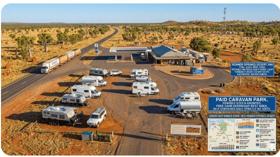
Renner Springs Desert Inn Caravan Park — Paid Option
The Desert Inn has a small caravan park attached to the roadhouse. Facilities include:
- Powered and unpowered sites for caravans, motorhomes and campervans
- Toilets and hot showers
- Dump point (grey and black water)
- Water fill
- Access to the bistro and bar
- Basic motel rooms and cabins also available
Sites are generally gravel or natural ground. Shade is limited on some sites. Levelling blocks recommended. The park is suitable for rigs up to approximately 10 metres (double-check with management for longer combinations).
Full Facilities Comparison Table
| Facility | Desert Inn (Paid) | Renner Springs Rest Area (Free) | Three Ways Rest Area (Free) |
|---|---|---|---|
| Powered Sites | ✅ | ❌ | ❌ |
| Toilets | ✅ | ❌ | ✅ |
| Showers | ✅ | ❌ | ❌ |
| Dump Point | ✅ | ❌ | ❌ |
| Potable Water | ✅ (bore) | ❌ | ❌ |
| Fuel | ✅ | ❌ | ❌ |
| Food / Bistro | ✅ | ❌ | ❌ |
| Phone Signal (Telstra) | Patchy | Patchy | Patchy |
| Shade | Limited | Shelter | Shelter |
| Max Stay | No fixed limit | 24 hours | 24 hours |
Rates — All Options Near Renner Springs 2026
| Option | Approx. Rate (2026) | Notes |
|---|---|---|
| Desert Inn — Powered Site (2 persons) | $35–$45/night | Confirm current rate by phone. Prices increase periodically. |
| Desert Inn — Unpowered Site | $25–$35/night | Access to showers, toilets, dump point. |
| Desert Inn — Motel Room | $100–$150/night | Air-conditioned. Basic. Good for an extreme heat night. |
| Roadside Rest Areas | Free | Self-contained required. No facilities at most. |
The Renner Springs Day Plan for Seniors
| Time | Activity |
|---|---|
| 6:00 am | Wake. Coffee. Check road report (if you have signal). Birdwatching — dawn is best. |
| 7:00 am | Breakfast at your van or in the bistro. Fill water tanks. Top up fuel. |
| 8:00 am | Short walk around the grounds. Photograph the outback landscape. Check tyre pressures. |
| 9:00 am | Depart toward your next stop (north: Elliott/Daly Waters, south: Three Ways/Tennant Creek). Drive early, rest during midday heat. |
| 12:00 pm | If still at Renner Springs — lunch in the bistro or at your van in the shade. Nap. Read. |
| 4:00 pm | Afternoon walk. Socialise with other travellers. Sundowner at the bar. |
| 6:30 pm | Dinner — bistro or self-cooked. Sunset viewing. |
| 8:00 pm | Stargazing. The Milky Way is spectacular here — zero light pollution. |
Senior Checklist — Stuart Highway
- ☐ Fuel tank full before departing any town
- ☐ 20 L spare water per person
- ☐ 20 L jerry can of fuel (in approved container)
- ☐ Medications stored in cool bag or insulated container
- ☐ Fly net / head net — one per person
- ☐ Sunscreen SPF 50+ and hat
- ☐ First aid kit including compression bandages (snake bite protocol)
- ☐ Tyre repair kit and compressor
- ☐ Satellite communicator or EPIRB/PLB
- ☐ Cash ($200+ minimum)
- ☐ Offline maps downloaded (Google Maps or Hema Maps)
- ☐ Road report checked: roadreport.nt.gov.au
- ☐ Earplugs (road train noise at night)
- ☐ Levelling blocks
- ☐ Warm layers for June–August evenings
- ☐ Pre-trip vehicle check completed (see our Pre-Trip Vanlife Checklist)
What to Do Near Renner Springs — Senior Activity Guide
Renner Springs is not a tourist destination — it is a service stop in the outback. But for those who appreciate quiet, big-sky country, there are worthwhile experiences:
- Churchill’s Head: ~35 km north — a natural rock formation that resembles Winston Churchill’s profile. Roadside stop, wheelchair-accessible from the parking area.
- Attack Creek Historical Reserve: ~50 km north — marks the northernmost point reached by John McDouall Stuart on his 1860 expedition before being turned back by hostile terrain and Aboriginal resistance. Short walk to the memorial.
- Birdwatching: Dawn and dusk around any water source. Wild budgerigar flocks in season are spectacular.
- Stargazing: Zero light pollution. The Milky Way core is visible overhead from April to September.
- Photography: Sunrise and sunset light on the red earth is outstanding.
- Devil’s Marbles (Karlu Karlu): ~260 km south — one of Australia’s most iconic geological sites. Worth a day trip or overnight stay if heading south.
- Daly Waters Historic Pub: ~248 km north — a famous outback pub with memorabilia from decades of travellers. Entertainment in the dry season.
GPS Coordinates and Postcodes — Save Every Stop
| Location | Postcode | Latitude | Longitude | Source |
|---|---|---|---|---|
| Renner Springs Desert Inn | 0862 | -18.3225 | 133.8110 | Google Maps / public listing |
| Renner Springs Rest Area | 0862 | -18.329 | 133.810 | WikiCamps AU |
| Three Ways Junction | 0862 | -18.543 | 133.816 | Google Maps |
| Churchill’s Head | 0862 | -18.038 | 133.785 | WikiCamps AU |
| Elliott | 0862 | -17.556 | 133.547 | Google Maps |
| Tennant Creek | 0860 | -19.650 | 134.191 | Google Maps |
Stargazing at Renner Springs
Renner Springs is one of the darkest sky locations accessible by sealed road in Australia. There is virtually zero light pollution. On a clear winter night (May–August), you can see:
- The Milky Way core stretching from horizon to horizon
- The Magellanic Clouds (Large and Small)
- The Southern Cross with Pointers at optimal viewing angle
- Satellites and the International Space Station passing regularly
- Meteors — particularly during the Eta Aquariids (May) and Geminids (December)
Bring a reclining camp chair, a red-light torch (preserves night vision), and the free Stellarium app downloaded for offline use. Even a basic smartphone camera on night mode can capture remarkable shots of the Milky Way here.
History of Renner Springs
Renner Springs is named after Dr Frederick Renner, a medical practitioner associated with the Overland Telegraph Line construction in the 1870s. The spring itself was a vital water source for telegraph workers and drovers moving stock along the route that would eventually become the Stuart Highway.
The Overland Telegraph Line, completed in 1872, connected Darwin to Adelaide and thus Australia to the world via undersea cable to London. Repeater stations were placed at intervals, and water sources like Renner Springs determined where stops were established.
During World War II, the Stuart Highway was upgraded from a rough track to a military supply road — the only sealed corridor connecting the south to the Top End’s military installations. Renner Springs served as a staging point.
The Desert Inn itself has operated in various forms for decades, serving as a lifeline for road travellers in one of Australia’s most remote regions. Its bar walls carry the signatures and messages of thousands of grey nomads who have passed through.
Phone Signal and Emergency Communications
- Telstra: Patchy coverage at Renner Springs. You may get 1–2 bars outside or near the roadhouse. Data is very slow when available.
- Optus: No reliable coverage between Tennant Creek and Elliott.
- Vodafone/TPG: No coverage.
- Public WiFi: None. The roadhouse may have satellite internet for internal use only.
- Satellite phone (Iridium or Thuraya)
- Personal Locator Beacon (PLB) registered with AMSA
- Satellite messenger (Garmin inReach, SPOT)
- HF radio (if experienced)
Campfires and Cooking
Campfire rules in the Northern Territory vary by season and fire danger rating:
- Dry season (April–October): Total fire bans are frequently in place. Check Secure NT before lighting any fire.
- Wet season: Fires may be allowed but conditions change rapidly. Always check.
- Gas stoves: Generally permitted even during fire bans, but confirm — some areas restrict all open flame.
At the Desert Inn caravan park, ask staff about the current fire ban status. At rest areas, assume fires are banned unless a fire ring is provided and no ban signage is present.
Pets at Renner Springs Desert Inn
Pets are generally permitted at the caravan park — keep dogs on leads at all times. Be aware of:
- Snakes: King brown (mulga) snakes are common in this area. Keep your dog close and do not let them investigate burrows, wood piles or long grass.
- Ticks and paralysis ticks: Less common this far inland than in coastal areas, but check your pet daily.
- Heat: Dogs overheat faster than humans. Provide shade, constant water, and never leave a pet in a vehicle — even for minutes.
- Cane toads: Present in increasing numbers from Daly Waters northward. Lethal if licked or mouthed by dogs. Train your dog to avoid toads before heading north.
Accessibility for Seniors with Mobility Limitations
Renner Springs Desert Inn is a basic outback roadhouse. Accessibility is limited:
- Ground surface: Gravel and natural earth — uneven. Mobility scooters and wheelchairs will struggle outside paved areas.
- Toilet access: Standard cubicle. No dedicated accessible toilet is guaranteed — phone ahead to confirm if this is critical.
- Bistro/bar access: Generally accessible via ramp or flat entry, but facilities are older and not purpose-built for accessibility.
- Rest areas along the highway: Most have gravel pullover areas. Tables and shelters are on natural ground. Not wheelchair-friendly.
For seniors with significant mobility limitations, the most comfortable option is a powered site at the caravan park where you can set up your own accessibility aids (portable ramps, shower chairs, etc.) within your own rig.
Camping Etiquette and Waste Management
- Carry all rubbish out. There are no bins at most rest areas between Tennant Creek and Elliott.
- Use the dump point. Never dump grey or black water on the ground — even biodegradable soap harms this fragile environment.
- Generators: If running a generator at a rest area, observe the common courtesy of 7 am – 9 pm hours only, and position it as far from neighbours as possible.
- Noise: Grey nomad camps tend to be quiet communities. Keep music, TV and voices down after 9 pm.
- Leave your site clean. The next traveller should find it as good as — or better than — you did.
Emergency Scenarios — What to Do
| Scenario | Action |
|---|---|
| Vehicle breakdown | Pull completely off the road. Activate hazard lights. Stay with the vehicle — do NOT walk. Activate PLB/satellite communicator. Wait for help. Conserve water. |
| Medical emergency | Call 000 if you have signal. If not, activate PLB. Nearest hospital: Tennant Creek (~161 km south). RFDS can land on the highway if needed. |
| Snake bite | Apply pressure immobilisation bandage. Do NOT wash, cut or suck the wound. Stay still. Call 000 or activate PLB. See: Snake Safety Guide. |
| Road flooded | Do NOT attempt to cross. Turn back to the nearest safe rest area or roadhouse. Wait. Floodwaters can take hours or days to recede. If stranded, stay with the vehicle. |
| Out of fuel | Pull off the road. Flag down a passing vehicle or road train. Drivers on the Stuart Highway routinely help stranded travellers. Activate PLB if no traffic passes within 2 hours. |
| Heat exhaustion / heat stroke | Move to shade immediately. Remove excess clothing. Apply wet cloths to neck, armpits, groin. Sip cool water slowly. If confused or unconscious — call 000 / activate PLB. This is life-threatening. |
Packing List for This Section of Highway
- ☐ 20 L minimum water per person (40 L recommended)
- ☐ 20 L fuel in approved jerry can
- ☐ Tyre repair kit + 12V compressor
- ☐ Two spare tyres (van + tow vehicle)
- ☐ Recovery tracks or traction boards
- ☐ First aid kit with snake bite bandages
- ☐ PLB or satellite communicator
- ☐ Cash ($200+)
- ☐ Fly net (per person)
- ☐ Sunscreen SPF 50+ and wide-brim hat
- ☐ Warm jacket (June–August nights)
- ☐ Earplugs
- ☐ Offline maps (Hema Maps or Google Maps downloaded)
- ☐ Torch with spare batteries
- ☐ Shade awning or tarp
- ☐ Levelling blocks
- ☐ Gas stove with at least 2 spare canisters
- ☐ 3 days of non-perishable food (in case stranded)
- ☐ Medications (3 days extra supply)
- ☐ Vehicle recovery equipment (snatch strap, shackles)
- ☐ Rubbish bags (carry all waste out)
Rest Area Comparisons — Stuart Highway (Tennant Creek to Daly Waters)
| Rest Area | Toilet | Water | Shade | Table | Big Rig Friendly | Notes |
|---|---|---|---|---|---|---|
| Three Ways | ✅ | ❌ | ✅ | ✅ | ✅ | Junction area — road train noise |
| Renner Springs Rest Area | ❌ | ❌ | ✅ | ✅ | ✅ | Basic pullover |
| Churchill’s Head | ❌ | ❌ | ✅ | ✅ | ⚠️ | Smaller area — check for space |
| Lubra’s Lookout | ❌ | ❌ | ✅ | ⚠️ | ⚠️ | Scenic but small |
| Elliott free camp | ✅ | ⚠️ | ✅ | ✅ | ✅ | Town — fuel and basic supplies nearby |
Permits and Park Fees
- Stuart Highway rest areas: No permit required for overnight stops of up to 24 hours.
- Aboriginal land: Land adjoining the Stuart Highway is often Aboriginal land. Do not leave the road corridor or rest areas without a permit from the relevant land council (Central Land Council for this region — clc.org.au).
- National parks nearby: If visiting Devil’s Marbles / Karlu Karlu Conservation Reserve (south), a NT Parks Pass is required — available online or at the entry station.
- Renner Springs Desert Inn: No permit — pay caravan park fees directly to the roadhouse.
Reviews — What Real Grey Nomads Say
Collated from publicly available review platforms (Google, WikiCamps, Camps Australia Wide) — paraphrased summaries:
— Retired couple, QLD, July 2025
“Fuel, a cold beer, a hot shower and a flat spot for the caravan. Don’t expect the Hilton — this is outback NT. We slept well and moved on at dawn.”
— Solo female traveller, 62, VIC, August 2025
“I called from Tennant Creek. They told me the bistro was closing early that day. I grabbed lunch in town and arrived just for the overnight stop. Glad I rang.”
— Retired teacher, SA, June 2025
“I’ve seen dark skies before but Renner Springs is something else. Zero light pollution. The Milky Way was so bright it cast shadows. Worth stopping for that alone.”
People Also Ask — Renner Springs
Is Renner Springs worth stopping at?
Yes — as a fuel, rest and meal stop. It is not a tourist destination, but it fills a critical gap in the Stuart Highway services chain. For seniors, the hot shower, dump point and chance to eat a cooked meal are worth the cost.
How far is Renner Springs from Darwin?
Approximately 660 km south of Darwin via the Stuart Highway. Allow 7–8 hours driving without stops, but plan for at least one overnight break (Katherine or Mataranka are good midpoint stops).
Can I get LPG at Renner Springs?
LPG availability is unreliable at remote NT roadhouses. Phone ahead to check. If you depend on LPG, fill up in Tennant Creek or Katherine.
Is there a mechanic at Renner Springs?
No dedicated mechanic. Staff may be able to assist with minor issues. The nearest mechanical services are in Tennant Creek (south) or Katherine (north). For a serious breakdown, RACQ/RACT/AAA equivalent NT roadside assist or RFDS may be needed.
Frequently Asked Questions
Is Renner Springs Desert Inn still open in 2026?
Yes. It continues to operate as a fuel stop, bistro, bar, caravan park and accommodation facility. Phone (08) 8964 4505 to confirm hours before arriving.
How far is Renner Springs from Tennant Creek?
Approximately 161 km north along the Stuart Highway — about 1 hour 40 minutes driving.
Can I get diesel at Renner Springs?
Yes — diesel and unleaded. Prices are significantly higher than capital-city averages. EFTPOS can be unreliable; carry cash.
Is there free camping near Renner Springs?
Yes — roadside rest areas along the Stuart Highway allow overnight stops (24-hour limit). These are basic — most have a shade shelter and table only. Self-contained travellers only.
Does the Stuart Highway flood near Renner Springs?
Yes — particularly during the wet season (November–March). Check roadreport.nt.gov.au before travelling.
Is there phone signal at Renner Springs?
Telstra provides limited, patchy coverage. Optus and Vodafone have no reliable coverage. Carry a satellite communicator.
Are pets allowed at Renner Springs Desert Inn?
Generally yes — keep dogs on leads. Check for snakes. Phone ahead to confirm current pet policy.
Is there a dump point at Renner Springs?
Yes — at the Desert Inn caravan park. A small fee may apply for non-guests.
Quick-Reference Card
🟢 RENNER SPRINGS DESERT INN — QUICK CARD
| GPS: | -18.3225, 133.8110 |
| Postcode: | 0862 |
| Phone: | (08) 8964 4505 |
| Fuel: | Diesel & Unleaded — phone ahead |
| Next Fuel North: | Elliott — 90 km |
| Next Fuel South: | Three Ways — 24 km / Tennant Creek — 161 km |
| Nearest Hospital: | Tennant Creek — 161 km south |
| Phone Signal: | Telstra — patchy. Others — nil. |
| Best Months: | May – August |
| Road Report: | roadreport.nt.gov.au / 1800 246 199 |
| Emergency: | 000 (if signal) or activate PLB |
🗺️ Interactive Free Camp Finder Map
Use our interactive map below to find free camps, rest areas and overnight stops near Renner Springs and along the Stuart Highway. Enable your device’s location services for the best results. You can save spots, get directions and plan your route.
COPY PROMPT ➔ ASK AI ➔ SAVE TO FORM ➔ ADD SPOT PIN ➔ GET DIRECTIONS
📍 Interactive map — find free camps, rest areas and overnight stops. Enable location for best results.
Related Guides on Retire To Van Life
- Grey Nomads Guide 55+
- Best Routes to Drive Around Australia
- Travel Australia on a Pension
- Vanlife & Age Pension — Centrelink
- Healthcare and Budget on the Road
- Storing Medication Safely While Travelling
- Australian Snake Safety — Grey Nomads
- Australian Spider Safety — Grey Nomads
- Stay Connected on the Road — Internet & Phone Plans
- What Rangers Look For — Overnight Van Parking
- Van Safety Upgrades
- Pre-Trip Vanlife Checklist
- Caravan Maintenance — Australia
- How to Choose the Right Van — Over 55s Guide
- Adelaide River Showgrounds (NT stop)
- Hayes Creek Rest Area (NT stop)
Disclaimer
⚠️ Disclaimer: This guide is for general information only and is current as of January 2026. Conditions, prices, opening hours, fuel availability and road status change without notice in remote Australia. Always phone ahead, check road reports and carry emergency supplies. Retire To Van Life is not responsible for any loss, damage, injury or inconvenience resulting from the use of this information. Coordinates are sourced from publicly available mapping platforms and should be verified with your own GPS device. This website may contain affiliate links — see our full disclosure policy. Travel at your own risk.
Free campsites and powered sites fill fast during school holidays and peak season. If your preferred site is already gone, search remaining accommodation options below to explore the region.
Accommodation and flight search powered by Expedia. Booking through this search supports this website at no extra cost to you. As an affiliate, I earn from qualifying purchases at no extra cost to you.

As an affiliate, I earn from qualifying purchases at no extra cost to you.
As an affiliate, I earn from qualifying purchases at no extra cost to you.
1a;”>