Gara River Rest Area
A practical senior grey nomad guide to the Gara River Rest Area near Armidale NSW — covering GPS coordinates, facilities, overnight rules, safety, medical access and honest arrival expectations for caravans, motorhomes and campervans on the New England Highway.
📅 Last reviewed: June 2026 | Armidale NSW 2350 | New England Highway corridor — rules and facilities subject to change, always verify on arrival against current signage
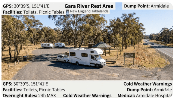
The Gara River Rest Area sits on the New England Highway south of Armidale in northern NSW, positioned in a river valley corridor that offers a genuine break from highway driving for grey nomads travelling between Sydney and Queensland. The Gara River itself is a tributary of the Mann River system, and the rest area takes its name from the waterway that runs nearby. For senior travellers on the New England Highway, this stop represents a useful overnight option in a region where formal free camping is limited — but it comes with the honest caveats that apply to all roadside rest areas: basic facilities, highway noise, no dump point, and rules that can change without notice.
- Name: Gara River Rest Area
- State: NSW
- Use: Roadside rest area — driver fatigue stop and overnight rest
- Best for: Caravans, motorhomes and campervans on the New England Highway needing an overnight stop between Armidale and Guyra
- Toilets: Pit toilets reported at this location — confirm on arrival as maintenance status varies
- Dump point: Not on site — nearest in Armidale (approximately 20km north)
- Potable water: Not reliably available — carry your own supply
- Power: No power — solar and battery essential for CPAP and device charging
- Phone signal: Telstra variable in river valley — test on arrival before relying on coverage
- Nearest town: Armidale NSW 2350 (approximately 20km north on New England Highway)
- Nearest major services: Armidale NSW 2350 — hospital, supermarkets, pharmacy, dump point
Table of Contents
- Location, address and GPS
- Can you stay overnight at Gara River Rest Area?
- Facilities: toilets, water, bins and dump point
- Nearby public Wi-Fi and mobile coverage
- How to get there
- What to expect on arrival
- Safety for senior grey nomads
- Medical and emergency contacts
- Dump points, water and supplies nearby
- Things to do for seniors in the area
- Best time of year to stop here
- Fires, generators and overnight etiquette
- Packing checklist for seniors
- GPS coordinates and postcodes: save every stop
- Frequently Asked Questions
- Quick verdict
Section 1 — Location, Address and GPS
The Gara River Rest Area is located on the New England Highway south of Armidale, in the Northern Tablelands region of NSW. The rest area sits in a river valley setting as the highway descends from the New England Plateau toward the gorge country east of Armidale. The surrounding landscape is characterised by dry sclerophyll forest, granite outcrops and the Gara River corridor — a tributary of the Mann River system flowing east toward the gorge.
📍 GPS Reference — Gara River Rest Area
New England Highway, south of Armidale NSW 2350 — approximately 20km south of Armidale CBD on the highway heading toward Uralla and Tamworth.
📍 Secondary Reference — Armidale Town Centre
Armidale NSW 2350 — nearest major town for services, fuel, dump point and hospital access.
| Detail | Information |
|---|---|
| Rest Area Name | Gara River Rest Area |
| State | New South Wales (NSW) |
| Postcode | 2350 (Armidale region) |
| Highway | New England Highway (A15) |
| Direction | Southbound side of highway, approximately 20km south of Armidale |
| Nearest Town | Armidale NSW 2350 (approximately 20km north) |
| Next Town South | Uralla NSW 2358 (approximately 15km south) |
| Land Manager | Transport for NSW (roadside rest area) |
| Local Government Area | Armidale Regional Council |
| Terrain | River valley — some uneven ground, tree-lined, gravel surface areas |
| Coordinates Accuracy Note | Planning coordinates only — confirm entry point against current highway signage on arrival |
For a broader list of verified free camping and rest area GPS stops across NSW, see our Vanlife Savings Spots guide.
Section 2 — Can You Stay Overnight at Gara River Rest Area?
Yes — overnight stays are generally permitted at this roadside rest area, as is standard for Transport for NSW managed rest areas on the New England Highway. Rest areas on NSW state highways are intended to support driver fatigue management and typically allow stays of up to 20–24 hours. However, this is a rest area — not a designated campsite — and the rules governing overnight stays are subject to change by Transport for NSW at any time.
The distinction between a rest area and a designated campsite matters practically: rest areas are provided for fatigue management, not as free camping destinations. Extended multi-night stays, group gatherings and behaviours associated with camping rather than resting are more likely to attract ranger attention and may result in enforcement action or the installation of “No Camping” signage that restricts future access.
- Overnight stays of one night are generally accepted and consistent with Transport for NSW rest area policy
- Stays beyond 24 hours are discouraged and may be enforced against at the discretion of local rangers or police
- No permanent or semi-permanent setup — do not erect annexes, outdoor furniture arrangements or camp kitchen setups that signal multi-night camping intent
- The rest area is on a public highway — it is accessible to all road users at all times of day and night
- Always check for any new signage on arrival — posted limits and rules may have changed since this guide was written
Section 3 — Facilities: Toilets, Water, Bins and Dump Point
Gara River Rest Area is a basic roadside stop. Facilities are limited and should not be assumed present or functional without confirmation on arrival. The following table reflects what has been reported at this location — but facility status at any roadside rest area can change due to vandalism, maintenance, seasonal closure or upgrade works.
| Facility | What Is Available | What Seniors Should Know |
|---|---|---|
| Toilets | Pit or drop toilet reported at this location. Condition and cleanliness variable — dependent on maintenance frequency. | Carry your own toilet paper and hand sanitiser regardless of toilet availability. Pit toilets may not be accessible for those with significant mobility limitations — a portable cassette toilet is a practical backup. |
| Potable Water | No reliable potable water supply at this rest area. The Gara River is nearby but is not a safe drinking water source without treatment. | Fill your fresh water tank in Armidale before arriving. Do not rely on finding potable water at the rest area. Carry a minimum 20 litres of drinking water per person for overnight stays. |
| Dump Point | Not on site. Nearest dump point is in Armidale — approximately 20km north. | Plan cassette or black tank disposal before arriving at camp. Armidale has dump point access — confirm current location with Armidale Regional Council (02 6770 3600) before making a specific trip. |
| Showers | No showers at this rest area. | Nearest shower access is at Armidale caravan parks. A solar shower bag is a practical alternative for short stays at this location. |
| Bins | Bins may be present — status varies. Do not assume bin availability. | Pack in, pack out as your default approach at this rest area. Carry your own rubbish bags and take all waste to the next town for disposal. |
| Power | No power at this rest area. | CPAP users must use battery banks or solar. The New England Tablelands is a reasonable solar location — a 200W panel and 100Ah battery system will comfortably cover CPAP and device charging needs overnight at most times of year. |
Section 4 — Nearby Public Wi-Fi and Mobile Coverage
Mobile coverage at Gara River Rest Area is variable. The rest area sits in a river valley as the New England Highway descends from the plateau, and valley topography can significantly reduce or eliminate mobile signal even where coverage maps show nominal Telstra presence. Test your signal on arrival before relying on connectivity for any critical communication.
- At the rest area: Telstra is the most likely network to have some coverage — but signal in the valley corridor can be weak to non-existent depending on your exact position and the local topography. Optus and Vodafone coverage is minimal to absent at this location.
- Armidale township (2350) — 20km north: Good Telstra, Optus and Vodafone 4G coverage throughout the city. Free public Wi-Fi available at Armidale City Library (114 Faulkner Street, Armidale) during business hours. McDonald’s on Mann Street also provides free Wi-Fi.
- Uralla township (2358) — approximately 15km south: Telstra coverage in town. Limited Optus presence. No public Wi-Fi confirmed — check at the local visitor centre or service station.
- Guyra (2365) — approximately 35km north of Armidale: Telstra coverage in town. Small township with basic services — do not rely on finding public Wi-Fi here.
- New England Highway corridor between Armidale and Tamworth: Telstra provides reasonable coverage through the main highway towns. Coverage drops in some valley sections between towns. Download offline maps before leaving Armidale.
Section 5 — How to Get There
Gara River Rest Area is accessed directly from the New England Highway south of Armidale. It is a straightforward highway rest area entry — no unsealed roads or complex navigation required for most travellers.
From Armidale (northbound travellers heading south)
From Armidale city centre, head south on the New England Highway (A15) toward Uralla and Tamworth. After approximately 18–22km, watch for the Gara River Rest Area sign on the left (eastbound) side of the highway. The entry is signed from the highway — do not attempt to enter at speed. Indicate early and slow well before the entry point, particularly if towing a long van.
From Tamworth or Uralla (southbound travellers heading north)
From Uralla township, head north on the New England Highway toward Armidale. After approximately 13–17km, watch for the rest area sign on the right (westbound) side of the highway. The highway climbs from the valley floor toward the Armidale plateau in this direction — truck traffic can be slow on the ascent. Allow extra following distance from heavy vehicles in this section.
Driving notes for seniors towing vans
- The New England Highway between Armidale and Uralla includes descent into and ascent from the Gara River valley — grades are moderate but require engaged engine braking when towing on the descent. Use a lower gear rather than riding the brakes on the downhill approach.
- The rest area entry from the highway requires slowing from open highway speed — signal well in advance and check mirrors for following traffic before reducing speed significantly.
- Heavy vehicle traffic is common on the New England Highway in both directions — maintain awareness of road trains and B-doubles overtaking or approaching from behind, particularly on the valley descent.
- The rest area surface may include gravel or uneven ground — approach at low speed and assess the surface before committing your full rig into a specific bay.
- Avoid arriving at the rest area during dusk or dawn if possible — wildlife activity (kangaroos, wallabies, wombats) increases significantly in the valley corridor at these times and the highway here has documented wildlife collision risk.
- If approaching from the south in winter, be aware that the New England Highway plateau sections between Armidale and Guyra are prone to black ice and frost — particularly overnight and in early morning. Check road conditions before departure in winter months.
Section 6 — What to Expect on Arrival
Gara River Rest Area is a standard Transport for NSW roadside rest stop — functional and free, but without the polished facilities of a purpose-built grey nomad camp. Arrive with realistic expectations and you will find it a perfectly adequate overnight stop in a pleasant river valley setting. Arrive expecting a campsite and you may be disappointed.
- The rest area provides a pullout from the New England Highway with basic parking for vehicles and vans — spaces for large rigs exist but may be limited in number. Arrive by early afternoon to secure a suitable bay for a long caravan or motorhome.
- The setting in the Gara River valley is genuinely attractive — dry sclerophyll forest, granite outcrops and the sound of the river (when flowing) provide a more pleasant environment than a standard highway verge stop. The valley is cooler than the surrounding plateau in summer and colder overnight in winter.
- Highway noise is present but typically lighter than major highway rest areas closer to Sydney or Brisbane — the New England Highway through this section carries moderate traffic with a significant overnight reduction compared to coastal routes.
- The rest area is on a public road — it is accessible to all passing traffic at all hours. Expect occasional vehicle stops throughout the night, including truck drivers taking mandatory rest breaks.
- Ground surface at the rest area may be uneven, grassed or gravelled depending on the specific bay — walk the area in daylight before moving around it after dark, and note any guy rope or trip hazards before night falls.
Section 7 — Safety for Senior Grey Nomads
Personal safety
- Gara River Rest Area is a public highway stop — it is not isolated from passing traffic. This provides a basic level of social visibility but also means that any member of the public can access the rest area at any time. Lock all vehicle and van doors at night as a standard precaution regardless of how quiet the area appears.
- The valley setting means mobile coverage is variable to poor — test your signal on arrival. If you cannot make or receive calls from this location, ensure your check-in contact knows your position and your expected departure time before you lose signal.
- Solo travellers should inform a trusted contact of their location at this specific rest area — including the GPS coordinates — before settling in for the night. See our caravan security guide for practical van security steps applicable to highway rest area stops.
- Trust your instincts on arrival — if the rest area is occupied by individuals whose behaviour concerns you, or if the location feels unsafe for any reason, continue driving to Armidale or Uralla and find an alternative stop. There is no obligation to stay.
- Keep a charged personal mobile phone and a backup power bank accessible at all times, including overnight. A flat phone in a location with variable coverage is a significant problem in an emergency.
Trip safety
- Share your itinerary with a trusted contact before heading into the valley corridor — include your planned stop at Gara River Rest Area, your GPS coordinates and your expected departure time the following morning.
- The New England Highway in winter is subject to black ice and frost conditions on the plateau sections north and south of the rest area. If departing in the early morning during winter months, check road surface conditions before pulling onto the highway — particularly on bridge decks and shaded sections.
- Wildlife collision risk is elevated in the valley corridor at dusk and dawn. If departing at these times, reduce speed and use high beams where traffic conditions allow.
- Carry a minimum three-day supply of any prescription medications. The nearest pharmacy is in Armidale, approximately 20km north — accessible during business hours but not in a late-night emergency.
- A personal locator beacon (PLB) is recommended for all overnight stays at rest areas with limited mobile coverage — valley locations like this one can have no usable signal for making emergency calls. A PLB works regardless of mobile network availability.
Section 8 — Medical and Emergency Contacts
The nearest hospital to Gara River Rest Area is Armidale Hospital, approximately 20–22km north on the New England Highway. This is a reasonable distance for a medical emergency by road — but in a serious cardiac or stroke event, call 000 immediately and do not attempt to drive yourself to hospital.
| Service | Address | GPS | Phone |
|---|---|---|---|
| Armidale Hospital | 152 Barney Street, Armidale NSW 2350 | -30.5089° S, 151.6717° E | (02) 6776 8400 |
| Tamworth Rural Referral Hospital | Dean Street, Tamworth NSW 2340 | -31.0833° S, 150.9167° E | (02) 6767 7777 |
| Emergency (Police, Fire, Ambulance) | Australia-wide | — | 000 |
| Healthdirect (24hr nurse helpline) | Australia-wide | — | 1800 022 222 |
| NSW Poisons Information Centre | Australia-wide | — | 13 11 26 |
Section 9 — Dump Points, Water and Supplies Nearby
There is no dump point at Gara River Rest Area. Grey nomads with cassette toilets or black water tanks must plan their disposal stop in Armidale before arriving at or after departing from this rest area. All essential supplies for the New England Highway corridor are available in Armidale, approximately 20km north.
| Need | Best Nearby Option | Notes |
|---|---|---|
| Dump Point | Armidale — confirm current location with Armidale Regional Council (02 6770 3600) or check Campermate for the most recent reported dump point address in Armidale. | Approximately 20km north on New England Highway. Complete dump point stop before heading south to the rest area — do not assume you can return easily with a full black tank. |
| Fresh Water | Armidale town taps, service stations and caravan parks. Uralla township approximately 15km south also has town water access. | Fill your fresh water tank to capacity before arriving at the rest area. No potable water on site. Carry a minimum 20 litres per person for overnight stays. |
| Groceries and Fuel | Armidale — Woolworths (Rusden Street), Coles (Coles Shopping Centre), Aldi (New England Highway), multiple independent fuel stations. Uralla has a small IGA and fuel. | Fuel prices in Armidale are generally reasonable for a regional city. Do not rely on Uralla for a full shop — stock up in Armidale before heading south. |
| Major Supplies | Armidale — Bunnings, pharmacies (multiple), medical centres, hospital. Full regional city services. | Armidale is one of the better-serviced regional cities on the New England Highway. Take advantage of its full services before heading into the more limited supply zones south toward Tamworth. |
| Alternative Town | Uralla NSW 2358 — approximately 15km south of the rest area. Small town with basic fuel and convenience shopping. | Uralla is a pleasant small town worth a stop for morning coffee or fuel — but for full supplies, Armidale is the correct planning stop. |
For advice on planning your powered site and dump point stops as part of an extended New England Highway grey nomad trip, see our guide on how long you can stay in a caravan park in Australia.
Section 10 — Things to Do for Seniors in the Area
The Gara River Rest Area sits within easy reach of the New England Tablelands’ most senior-friendly experiences — Armidale’s heritage architecture, gallery and cathedral precinct, the spectacular gorge country to the east, and the historic pastoral town of Uralla to the south.
| Activity | Location | Why Seniors Like It |
|---|---|---|
| Armidale Cathedral and Mall precinct | Armidale city centre NSW 2350 | Flat, walkable heritage streetscape with twin cathedrals, cafés, galleries and the New England Regional Art Museum (NERAM). Fully accessible. Free entry to most attractions. |
| Dangars Gorge Lookout | Oxley Wild Rivers National Park, east of Armidale | Spectacular gorge lookout with sealed car park and short walk to the viewing platform. No steep descent required. One of NSW’s most dramatic gorge views accessible without significant hiking. |
| Uralla Historic Township | Uralla NSW 2358 (15km south) | Captain Thunderbolt heritage trail, historic cemetery and pleasant main street cafés. Flat, slow-paced country town ideal for a morning wander. Free. |
| New England Regional Art Museum (NERAM) | Kentucky Street, Armidale NSW 2350 | One of regional Australia’s finest art collections. Fully accessible, air-conditioned, café on site. Free entry to permanent collection. Ideal for a cool or wet day. |
| Gara Gorge area walks | East of Armidale via Waterfall Way | The Gara River gorge area has several lookouts and short walk options. Some are accessible by sealed road with minimal walking. Confirm track conditions before visiting. |
Best Senior-Friendly Ideas at Gara River Rest Area
- Use the rest area as a base for a morning drive to Dangars Gorge lookout — the sealed road access and viewing platform make it one of the most accessible gorge views in NSW without requiring a significant walk.
- Armidale’s heritage mall precinct is flat and fully accessible — arrive on a weekday morning to enjoy the café strip and twin cathedral precinct without weekend tourist crowds.
- The New England Regional Art Museum is genuinely world-class for a regional institution — plan at least two hours and combine it with lunch in the Armidale CBD before returning to the rest area.
- Uralla’s Captain Thunderbolt heritage is fascinating for history enthusiasts — the town’s connection to one of Australia’s last bushrangers is well-interpreted through a self-guided heritage trail brochure available from the Uralla Visitor Centre.
- Waterfall Way east of Armidale leads to some of NSW’s most spectacular gorge and waterfall country — even a short drive along this road in the direction of Ebor Falls rewards with dramatic landscape views without requiring any significant walking.
For inspiration on making the most of extended stops in regional areas like the New England Tablelands, read our guide to living in a camper full-time.
Section 11 — Best Time of Year to Stop Here
| Season | What It Is Like | Senior Verdict |
|---|---|---|
| Summer (Dec–Feb) | Mild to warm days on the New England Plateau (22–28°C) — significantly cooler than coastal and inland NSW. Valley rest area is pleasant in the day. Afternoon thunderstorms are common. Good rainfall period — river may be flowing well. | Good summer stop for travellers escaping coastal heat. The New England Tablelands are one of the cooler inland regions of NSW in summer. Be aware of afternoon storm risk and ensure your van is storm-ready. |
| Autumn (Mar–May) | Beautiful season on the New England. Cool, clear days and progressively colder nights. Valley temperatures drop noticeably as the season advances — by May, overnight temperatures in the valley are regularly below 5°C. | Excellent in March and April. May requires adequate heating. The autumn colour in Armidale’s tree-lined streets is genuinely spectacular — a worthwhile detour if your timing aligns. |
| Winter (Jun–Aug) | Cold to very cold. Armidale is one of the coldest cities in NSW with regular overnight frosts and occasional snowfall on the plateau. The rest area valley frost hollow effect makes overnight temperatures here colder than the plateau forecast. July temperatures can drop below zero overnight. | Not recommended for travellers without reliable van heating. If your diesel heater or reverse cycle is in good working order, winter on the New England is clear, crisp and beautiful — but you must be properly equipped. Snowfall on the highway is rare but possible. |
| Spring (Sep–Nov) | Warming temperatures from October. September still cold at night. October and November are excellent — mild days, cool nights, wildflowers in the surrounding bush. The highway is busy with grey nomads heading north for winter from September onward. | Excellent from October onward. September requires heating overnight. The spring wildflower season in the New England National Park and surrounding bush is worth timing a visit around if your schedule allows. |
Section 12 — Fires, Generators and Overnight Etiquette
Gara River Rest Area is a public roadside stop managed by Transport for NSW. The rules that apply here are consistent with standard NSW roadside rest area conditions — and compliance is important both for legal reasons and to protect access for all future grey nomad travellers.
- Open fires: Prohibited at all Transport for NSW roadside rest areas. Do not light any open fire at Gara River Rest Area under any circumstances. During NSW Rural Fire Service Total Fire Ban periods, no fire of any kind is permitted — including solid fuel camp stoves. Check the NSW RFS website or app before any campfire consideration in the surrounding region. Gas stoves remain permitted during total fire bans.
- Generators: Not appropriate at roadside rest areas. Other rest area users — including truck drivers taking mandatory rest breaks — are entitled to a reasonably quiet environment. Do not run a generator at any time at this rest area. Solar and battery are the appropriate power solution for this stop.
- Noise: Keep all audio at low levels from 9pm. Travelling truck drivers may be sleeping nearby and deserve the same consideration you would want in their position.
- Rubbish: Pack in, pack out. Do not leave rubbish at this rest area. Rubbish dumping is the primary cause of rest area facility removal and access restriction across NSW.
- Grey water and black water: Do not discharge grey water or black water onto the ground at this rest area or anywhere adjacent to the Gara River. This is an environmental offence and a direct threat to the waterway and to future access at this location.
- Length of stay: Do not overstay the 20–24 hour rest area limit. If you need an extended stop in the area, contact Armidale Regional Council about local camping options or book a powered site at an Armidale caravan park.
Section 13 — Packing Checklist for Seniors
The Gara River Rest Area’s combination of cold valley temperatures, limited mobile coverage, no potable water, no dump point and distance from emergency services means your packing list needs to reflect the specific conditions of this location rather than a generic camping setup.
| Item | Why It Matters at This Location | ☐ |
|---|---|---|
| Diesel heater or effective van heating | Valley frost hollow effect — overnight temperatures regularly below 5°C in autumn and winter, occasionally below zero in July and August. Inadequate heating here is a genuine cold exposure risk for seniors. | ☐ |
| 20+ litres potable water per person | No reliable potable water on site. Fill in Armidale before arriving — 20km return trip for water is inefficient and unnecessary with proper planning. | ☐ |
| Portable cassette toilet | Pit toilet on site may be non-functional, inaccessible or inadequate — a portable toilet is your reliable backup for overnight stays at any rest area. | ☐ |
| Battery bank or solar system (100Ah+) | No power on site. CPAP users and those with medical devices requiring charging must bring adequate off-grid power. The New England Tablelands has good solar resource in clear conditions. | ☐ |
| Minimum 3-day prescription medication supply | Nearest pharmacy is in Armidale (20km north) — accessible during business hours only. Always carry extra supply for unplanned delays. | ☐ |
| Registered PLB | Mobile coverage in the valley is variable to non-existent. In a medical emergency or serious situation where you cannot make a phone call, a PLB is your emergency signal device. | ☐ |
| Quality headlamp and spare batteries | Night movement at this rest area on uneven ground is a fall risk — reliable lighting is essential for any trip to the toilet after dark. | ☐ |
| Warm bedding layers (sleeping bag rated to 0°C) | Even with van heating, a cold-rated sleeping bag provides backup warmth if heating fails overnight in winter conditions at this valley location. | ☐ |
| Rubbish bags and waste management kit | Bin availability is variable. Pack in, pack out is the correct approach — carry all waste to Uralla or Armidale for disposal. | ☐ |
| Non-slip step covers for van entry | Morning dew and overnight frost make van steps extremely slippery in autumn and winter. Non-slip covers are a low-cost, high-value fall prevention measure at this location. | ☐ |
COPY PROMPT ➔ ASK AI ➔ SAVE TO FORM ➔ ADD SPOT PIN ➔ GET DIRECTIONS
📍 Interactive map — find free camps, rest areas and overnight stops near Gara River Rest Area. Enable location for best results.
Section 14 — GPS Coordinates and Postcodes: Save Every Stop
Save these coordinates offline before leaving Armidale’s mobile coverage. The valley corridor around Gara River Rest Area may have limited or no signal — having offline GPS references is essential for confident navigation in this section of the New England Highway.
| Location | Address + Postcode | GPS | Notes |
|---|---|---|---|
| Gara River Rest Area | New England Highway, south of Armidale NSW 2350 | -30.5917° S, 151.6583° E | Planning coordinates only — confirm entry against highway signage on arrival |
| Armidale (Nearest Town) | Beardy Street Mall, Armidale NSW 2350 | -30.5131° S, 151.6664° E | Full services — fuel, groceries, pharmacy, dump point, hospital |
| Armidale Hospital | 152 Barney Street, Armidale NSW 2350 | -30.5089° S, 151.6717° E | Nearest hospital — approximately 20–22km north of rest area |
| Tamworth Rural Referral Hospital | Dean Street, Tamworth NSW 2340 | -31.0833° S, 150.9167° E | Major referral hospital — approximately 110km south for specialist services |
| Uralla (Next Town South) | Bridge Street, Uralla NSW 2358 | -30.6417° S, 151.5083° E | Small town — basic fuel and convenience. Approximately 15km south of rest area. |
For a comprehensive collection of verified GPS coordinates for free camping and overnight stops across NSW and Australia, bookmark our Vanlife Savings Spots guide and refer to it before each leg of your New England Highway journey.
Section 15 — Frequently Asked Questions
Is Gara River Rest Area free to camp at?
Yes — Gara River Rest Area is a Transport for NSW roadside rest area and there is no cost to stop or stay overnight. As with all NSW roadside rest areas, no booking is required and no fee applies. The rest area is available to all road users on a first-come, first-served basis. However, free does not mean unrestricted — the standard rest area rules regarding stay duration, fires, generators and waste disposal all apply and should be observed.
Can caravans and motorhomes stay overnight at Gara River Rest Area?
Yes — caravans and motorhomes can stay overnight at Gara River Rest Area consistent with the standard Transport for NSW rest area overnight policy, which permits stays up to 20–24 hours for fatigue management purposes. Larger rigs should arrive by early to mid-afternoon to assess the available bays and ensure a suitable space is available. Do not attempt to back a large van into the rest area in the dark without a prior daylight assessment of the layout.
What is the GPS for Gara River Rest Area?
The primary planning GPS coordinates for Gara River Rest Area are -30.5917° S, 151.6583° E. These are publicly available planning coordinates. Always confirm the exact entry point against current highway signage on approach — rest area entry points can shift following road works or signage updates. Save the coordinates offline before leaving Armidale as mobile coverage in the valley corridor may be limited.
Are there toilets at Gara River Rest Area?
A pit or drop toilet has been reported at this location. However, toilet condition, cleanliness and accessibility at roadside rest areas is variable and dependent on maintenance frequency. Do not rely on the toilet being functional or accessible on arrival — carry a portable toilet solution as a standard part of your grey nomad kit, and always carry your own toilet paper and hand sanitiser regardless of what facilities are present.
Is there a dump point at Gara River Rest Area?
No — there is no dump point at Gara River Rest Area or at any Transport for NSW roadside rest area on the New England Highway. The nearest dump point is in Armidale, approximately 20km north of the rest area. Confirm the current dump point location with Armidale Regional Council (02 6770 3600) or check Campermate for recent user-reported dump point locations in Armidale before making a specific trip.
Can you get potable water at Gara River Rest Area?
No — there is no reliable potable water supply at this rest area. The Gara River nearby is not a safe drinking water source without appropriate filtration and chemical treatment. Fill your fresh water tank at a confirmed town tap in Armidale (20km north) or Uralla (approximately 15km south) before arriving at the rest area. Carry a minimum 20 litres of drinking water per person for overnight stays at this location.
Is Gara River Rest Area safe for solo senior travellers?
Generally yes, with appropriate precautions. The rest area is a public highway stop with passing traffic providing a degree of visibility. Lock all doors at night, inform a trusted contact of your location and expected departure time, test your mobile signal on arrival and have a PLB accessible if coverage is absent. Trust your instincts — if anything about the rest area feels wrong on arrival, continue to Armidale or Uralla and find an alternative stop without hesitation.
What is the nearest hospital to Gara River Rest Area?
The nearest hospital is Armidale Hospital at 152 Barney Street, Armidale NSW 2350, phone (02) 6776 8400 — approximately 20–22km north on the New England Highway. For serious cardiac events, major trauma or specialist intervention, patients may be transferred to Tamworth Rural Referral Hospital (approximately 110km south, phone 02 6767 7777) or to Newcastle or Sydney for tertiary services. In any life-threatening emergency, call 000 immediately and do not attempt to drive yourself to hospital.
How cold does it get overnight at Gara River Rest Area in winter?
Very cold — and colder than the Armidale plateau forecast suggests. The Gara River valley acts as a frost hollow, collecting cold air that drains from the surrounding plateau overnight. In June, July and August, overnight temperatures at the rest area can drop below zero degrees Celsius, with frost on the ground by morning being common. Travellers without reliable van heating — a diesel heater, reverse cycle air conditioner or adequately fuelled gas heater — should not overnight at this location in winter. Even in autumn (April and May), overnight temperatures regularly fall to 2–5°C. Come prepared for colder conditions than the regional forecast indicates.
Section 16 — Quick Verdict
Gara River Rest Area is a solid and legitimate overnight stop for grey nomads travelling the New England Highway between Sydney and Queensland — but it rewards those who arrive prepared and punishes those who arrive expecting more than a basic rest area provides. Its genuine strengths are real: it is free, it is accessible directly from the highway, it sits in a pleasant river valley setting that is more attractive than most highway verge stops, it is well-positioned between Armidale and Uralla for a one-night break, and it represents a genuine saving over a powered caravan park night on a route where those savings accumulate over weeks of travel. The surrounding New England Tablelands region — Armidale’s heritage, Dangars Gorge, the Waterfall Way east toward Ebor — adds real value for travellers who allow themselves time to explore rather than simply drive.
The honest weaknesses are equally clear. There is no dump point, no reliable potable water and no power — all of which require pre-planning in Armidale. Mobile coverage in the valley is variable and should not be assumed. The valley frost hollow effect makes this one of the colder overnight stops on the New England Highway in autumn and winter, and travellers without adequate heating should either equip themselves properly or choose a powered site in Armidale instead. And as with every roadside rest area, the overnight rules can change at any time — always check current signage on arrival and never assume that last year’s experience matches this year’s conditions. Go prepared, behave well, and Gara River Rest Area will serve you as a genuinely useful overnight stop on one of Australia’s great grey nomad highways. For more free camping GPS stops on the New England Highway and across Australia, see our Vanlife Savings Spots guide and our grey nomad routes planning guide.
- Browse all NSW free camping and vanlife savings spots
- New England Highway Grey Nomad Route Planning Guide
- Uralla Rest Area — New England Highway, Uralla NSW 2358 (approximately 15km south)
- Armidale Showground — Armidale NSW 2350 (confirm overnight access with Armidale Regional Council)
- Guyra Rest Area — New England Highway, Guyra NSW 2365 (approximately 35km north of Armidale)
- Tenterfield Rest Areas — New England Highway, Tenterfield NSW 2372 (north toward QLD border)
- Tamworth Rest Areas — New England Highway, Tamworth NSW 2340 (approximately 110km south)
- Walcha Road Rest Area — Oxley Highway junction area, west of Armidale
- Ben Lomond Rest Area — New England Highway, Ben Lomond NSW 2365
- Ebor area informal stops — Waterfall Way east of Armidale (scenic route — confirm access before attempting with large rigs)
- Moonbi Range Rest Area — New England Highway south of Tamworth NSW 2340
- Glen Innes Rest Areas — New England Highway, Glen Innes NSW 2370 (north of Armidale toward Queensland)
Free campsites and powered sites fill fast during peak season on the New England Highway. If Gara River Rest Area is occupied or conditions do not suit, search remaining accommodation options in Armidale and surrounds below.
Accommodation and flight search powered by Expedia. Booking through this search supports this website at no extra cost to you. As an affiliate, I earn from qualifying purchases at no extra cost to you.

As an affiliate, I earn from qualifying purchases at no extra cost to you.
Exclusive Offer: Get 5% OFF all StarterStopper immobiliser products with promo code: RTV5
Visit StarterStopper.com to see our data-backed security solutions
As an affiliate, I earn from qualifying purchases at no extra cost to you.