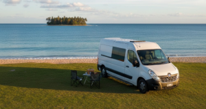
Mackay sits at the doorstep of the Whitsundays and the Great Barrier Reef — a genuinely tropical city surrounded by sugarcane, coral sea and some of the most beautiful national parks in Central Queensland. Your practical, retiree‑friendly guide to free camps, water points, dump points, fuel stops, Wi‑Fi, medical access, disability access and safety around Mackay. Whether you’re a grey nomad, caravanner or vanlifer, this guide gives you accurate GPS coordinates, access notes, amenities and local insights to help you travel confidently and comfortably.
Free Camping Near Mackay (Best Retiree‑Friendly Spots)
Mackay is a genuine regional city — it has a major hospital, a full range of services, great dump points, and enough free and low-cost camping in the immediate region to keep grey nomads comfortable for weeks. The city itself is one of Australia’s largest sugar-producing regions and is surrounded by ocean, national parks, waterfalls and tropical coastline. The honest reality of free caravan camping Mackay is that the council-managed camping reserves (St Helens Beach, Seaforth, Ball Bay) are low-cost rather than free, but they offer exceptional value, superb beachfront locations, and facilities that put most free camps to shame. True free options are found at Notch Point (90 km south), Mirani, and the Bruce Highway rest areas on either side of the city. One experienced grey nomad told us she’d based herself at St Helens Beach for seven nights every winter for five years running — the fishing, the sunsets and the peace simply never got old.
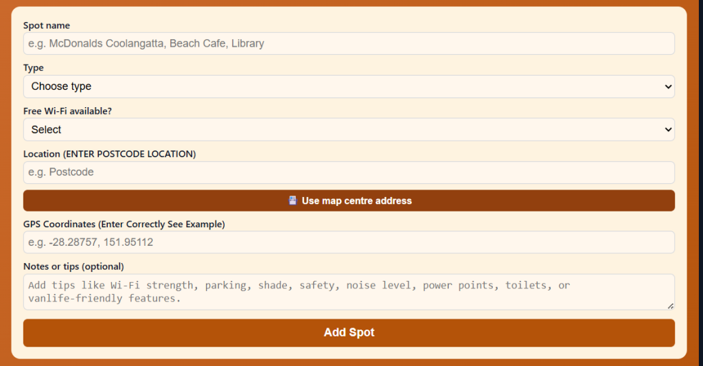
Use the Vanlife Savings Spots App to save your locations. Add your postcode, GPS coordinates and notes, then tap “Add Spot” to place it on the map and get directions.
St Helens Beach Camping Reserve – St Helens Beach QLD 4798
Distance from Mackay: Approx. 54 km north, via Bruce Highway and Pratt Road to Murrays Road Maximum Stay: 7 nights in a 21-day period — one of the most generous limits in the region Self‑Contained Required: No — toilets, showers and water on site Toilets On‑Site: Yes — wheelchair accessible toilets Toilet Address: Murrays Road, St Helens Beach QLD 4798 Toilet GPS: -20.8720, 148.9440 (approx.) Showers: Yes — coin-operated hot showers on site Pet‑Friendly: No — animals not permitted at this reserve Caravan‑Friendly / Big‑Rig Access: Yes — 2WD accessible; suitable for caravans and big rigs; the final 1.5 km to the camping area from Murrays Road is unsealed Campervan Access: Yes Camper Trailer Access: Yes Tent Camping Allowed: Yes Vehicle Restrictions: Generators permitted 8–11 am and 2–5 pm only (maximum 65 dB output) Telstra Reception: Yes — coverage reported on site GPS: -20.8720, 148.9440 (Public mapping data) Address: Murrays Road, St Helens Beach QLD 4798 Coordinate Source: Public mapping data
Note: Mackay Regional Council charges a low nightly camping fee — verify current rates at mackay.qld.gov.au or call 1300 MACKAY (622 529). No bookings required — camping attendants collect fees daily. A low-cost site, not technically free, but included here for its exceptional quality and proximity to Mackay.
Directions from Bruce Highway: Turn east off the Bruce Highway 400 m north of the St Helens Bridge in Calen, onto Pratt Road. Travel 2.5 km, then turn right onto Wewak Road. Travel 2 km, turn left onto St Helens Road (becomes St Helens Beach Road). Travel 8 km, turn right onto Murrays Road. The camping area is 1.5 km on unsealed road.
Accessibility (Disability‑Friendly Notes)
- Wheelchair-accessible toilets: Yes — wheelchair accessible toilet facilities on site
- Accessible parking: Yes — flat open area beside beach
- Pathway surface: Sealed road to Murrays Road; the final 1.5 km is unsealed but flat
- Mobility-friendly access to amenities: Good — flat site; short distances between parking and amenities
- Turning space for mobility devices: Good — open flat area
- Suitability for travellers with limited mobility: Good — flat beachside terrain; accessible toilets; good big-rig access
- Nearby accessible toilets: On-site; nearest town is Calen (approx. 12 km from beach)
- Emergency toilet options within 1–5 km: On-site
Access Notes
- Road type: Sealed Bruce Highway and connecting roads; final 1.5 km on Murrays Road is unsealed but well-maintained gravel — suitable for 2WD caravans with standard ground clearance
- Turning space: Open beach area; good turning space for large rigs
- Caravan/motorhome suitability: Excellent — large rigs have been recorded using this site
- Vehicle limitations: The unsealed 1.5 km section on Murrays Road may require care after heavy rain — check conditions
Why Retirees Like It
St Helens Beach is one of the best-value beachfront camping reserves in Central Queensland and it is genuinely remarkable that it costs so little. The site sits right on the beach with direct ocean views, a well-maintained boat ramp, covered picnic tables with BBQs and fireplaces, fresh water, coin-operated hot showers, and wheelchair-accessible toilets — a complete package. The 7-night limit is exceptional for council-managed sites. Fishing is excellent — the boat ramp makes it popular with anglers, and the foreshore fishing is productive at dawn and dusk. The sunsets are extraordinary. Camping attendants visit daily, so the site is well-supervised and maintained. This is the go-to self-contained camping Mackay experience for retirees who want beachfront access, real facilities, and a peaceful base from which to explore Cape Hillsborough and the northern coast.
Nearby Public Wi‑Fi Options
Calen Hotel (BP Roadhouse) – Calen QLD 4798 Address: Bruce Highway, Calen QLD 4798 Free Wi‑Fi: Enquire at roadhouse/hotel Toilets: Yes Toilet Address: Bruce Highway, Calen QLD 4798 Toilet GPS: -21.0280, 148.7770 (approx.) Parking suitability: Good — truck stop and wide forecourt Wi‑Fi GPS: -21.0280, 148.7770 Parking GPS: -21.0280, 148.7770
Driving Directions
➡ From Mackay, head north on Bruce Highway approx. 54 km ➡ 400 m north of St Helens Bridge in Calen, turn right onto Pratt Road ➡ 2.5 km ▶ Right onto Wewak Road ▶ 2 km ▶ Left onto St Helens Road (becomes St Helens Beach Road) ➡ 8 km ▶ Right onto Murrays Road ▶ 1.5 km unsealed ▶ Camping reserve and beach on left
Tips
- Arrival time: Afternoon — camping attendant collects fees daily; arrive before dark to find the best spot
- Coins: Bring coins for hot showers
- No pets: Strictly no animals — not negotiable
- Noise: Remote beachside location — very quiet; some early morning bird sound
- Wet season notes: January–March can bring heavy rain; the final unsealed road section may be soft; check conditions before travelling
- Safety: Well-maintained council-operated reserve; camping attendant visits daily; safe overnight
Seaforth Camping Reserve – Seaforth QLD 4741
Distance from Mackay: Approx. 47 km north-east via Seaforth Road off the Bruce Highway Maximum Stay: Weekly or nightly stays — contact council for current rates and booking Self‑Contained Required: No — toilets, showers and water on site Toilets On‑Site: Yes Toilet GPS: -20.8958, 148.9610 (approx.) Showers: Yes — hot showers available for a small fee Pet‑Friendly: No — dogs not permitted at this reserve Caravan‑Friendly / Big‑Rig Access: Yes — 2WD accessible; big rigs, motorhomes, caravans and camper trailers welcome Campervan Access: Yes Camper Trailer Access: Yes Tent Camping Allowed: Yes Vehicle Restrictions: Standard road rules apply Telstra Reception: Yes GPS: -20.8958, 148.9610 (Public mapping data) Address: Seaforth Road, Seaforth QLD 4741 Coordinate Source: Public mapping data
Note: Mackay Regional Council low-cost camping reserve. Bookings required — phone (07) 4966 4359 or 0427 373 358; maximum 3 months advance booking; EFTPOS on site; check in from 11 am; check out by 10 am. Verify current nightly rates with council.
Accessibility (Disability‑Friendly Notes)
- Wheelchair-accessible toilets: Yes — accessible facilities; verify current condition on arrival
- Accessible parking: Yes — flat open area
- Pathway surface: Flat open site; some grass and gravel
- Mobility-friendly access to amenities: Good — compact, flat site
- Turning space for mobility devices: Good
- Suitability for travellers with limited mobility: Good — flat coastal site
- Nearby accessible toilets: On-site; Seaforth township nearby
- Emergency toilet options within 1–5 km: On-site
Access Notes
- Road type: Sealed road from Bruce Highway through the Seaforth township; well-maintained
- Turning space: Good — open coastal site
- Caravan/motorhome suitability: Excellent; all rig types reported welcome
- Vehicle limitations: None noted
Why Retirees Like It
Seaforth is a peaceful coastal village on the Mackay coastline, close to Cape Hillsborough National Park and surrounded by tropical beaches. The camping reserve is popular with fishing enthusiasts and those who love birdwatching and walking along unspoiled coastal beaches. The proximity to Cape Hillsborough (where kangaroos and wallabies come down to the beach at sunrise) makes it an outstanding base for wildlife watching — one of the great Queensland dawn experiences. It’s a genuinely low-stress, low-cost camping Mackay option with proper facilities and a beautiful coastal setting.
Nearby Public Wi‑Fi Options
Mackay Visitor Information Centre – Mackay QLD 4740 Address: 320 Nebo Rd, West Mackay QLD 4740 Free Wi‑Fi: Yes Toilets: Yes — accessible Toilet Address: 320 Nebo Rd, West Mackay QLD 4740 Toilet GPS: -21.1660, 149.1540 (approx.) Parking suitability: Excellent — large dedicated carpark suitable for caravans Wi‑Fi GPS: -21.1660, 149.1540 Parking GPS: -21.1660, 149.1540
Driving Directions
➡ From Mackay, north on Bruce Highway approx. 35 km ➡ Turn right onto Seaforth Road — follow through township ➡ Seaforth Camping Reserve is on the waterfront — follow council signage
Tips
- Booking required: Phone ahead — (07) 4966 4359 or 0427 373 358
- Arrival time: Check in from 11 am; check out by 10 am
- Wildlife: Cape Hillsborough kangaroos at dawn are a must-see — 6 km north
- Noise: Coastal winds in the afternoon; sheltered overnight
- Wet season: Check road conditions December–March
Mirani Caravan Park – Mirani QLD 4754
Distance from Mackay: Approx. 36 km south-west via Homebush and Mirani Maximum Stay: Up to 6 weeks (holiday purposes and travellers only) Self‑Contained Required: No — facilities on site Toilets On‑Site: Yes Toilet GPS: -21.1590, 148.8640 (approx.) Showers: Yes Pet‑Friendly: Check current rules with council Caravan‑Friendly / Big‑Rig Access: Yes — council-managed; RV Town accreditation through CMCA Campervan Access: Yes Camper Trailer Access: Yes Tent Camping Allowed: Yes Vehicle Restrictions: None noted Telstra Reception: Yes GPS: -21.1590, 148.8640 (Public mapping data) Address: Mirani township QLD 4754 — verify current address with Mackay Regional Council (1300 622 529) Coordinate Source: Public mapping data
Note: Mirani township holds CMCA RV Town accreditation. Mirani Caravan Park is a council-operated low-cost site. Verify current nightly rates and policies with Mackay Regional Council on 1300 622 529.
Accessibility (Disability‑Friendly Notes)
- Wheelchair-accessible toilets: Yes — council-managed site
- Accessible parking: Yes — flat open area
- Pathway surface: Flat; generally good
- Mobility-friendly access to amenities: Good
- Suitability for travellers with limited mobility: Good — flat site in town
- Nearby accessible toilets: On-site; Mirani township (all services within walking distance)
- Emergency toilet options within 1–5 km: On-site and Mirani township
Access Notes
- Road type: Sealed road from the Bruce Highway into Mirani township
- Turning space: Good — council caravan park
- Caravan/motorhome suitability: Excellent — CMCA accredited RV-friendly town
- Vehicle limitations: None noted
Why Retirees Like It
Mirani is one of Central Queensland’s most welcoming grey nomad towns, holding official CMCA RV Town accreditation. The council-managed caravan park is affordable and the town is genuinely friendly to travellers. It sits in the Pioneer Valley between the sugarcane fields and the mountains of Eungella National Park — one of the most beautiful and biologically rich national parks in Queensland. Grey nomad camping Mackay travellers exploring the Pioneer Valley regularly use Mirani as a comfortable base. The Pioneer Valley Pub is within walking distance. And at up to 6 weeks maximum stay, you have the option of genuinely settling in.
Nearby Public Wi‑Fi Options
Mirani Library or Council Office – Mirani QLD 4754 Address: Mirani township QLD 4754 — verify current Wi-Fi access with council Free Wi‑Fi: Enquire with council or library Toilets: Yes — public facilities in township Toilet GPS: -21.1590, 148.8640 (approx.) Parking suitability: Good — wide country town streets Wi‑Fi GPS: -21.1590, 148.8640 Parking GPS: -21.1590, 148.8640
Driving Directions
➡ From Mackay CBD, head south-west on Peak Downs Highway ➡ Turn right onto Mirani Road at Homebush ➡ Approx. 36 km total ▶ Mirani township ▶ Caravan park is signposted in town
Tips
- Arrival time: Any time — less popular than coastal camps, more relaxed
- Eungella: Take a day trip up the mountain — platypus viewing at Broken River is extraordinary
- Weather: Mirani is inland — hot and humid in summer; perfect winter climate
- Safety: Friendly, safe country town
Mackay Visitor Information Centre Rest Stop – West Mackay QLD 4740
Distance from Mackay: 0 km — within Mackay city (northern Bruce Highway approach) Maximum Stay: Day stop and short-term rest — not overnight camping; use as a service stop Self‑Contained Required: N/A — day use only Toilets On‑Site: Yes — accessible public toilets Toilet Address: 320 Nebo Rd, West Mackay QLD 4740 Toilet GPS: -21.1660, 149.1540 (approx.) Showers: No Pet‑Friendly: Yes — outside, on lead Caravan‑Friendly / Big‑Rig Access: Yes — large dedicated carpark Campervan Access: Yes Camper Trailer Access: Yes Tent Camping Allowed: No — day use only Vehicle Restrictions: None Telstra Reception: Yes GPS: -21.1660, 149.1540 (Public mapping data) Address: 320 Nebo Road, West Mackay QLD 4740 Coordinate Source: Public mapping data
Note: The Mackay Visitor Information Centre is listed here as a key service hub, not an overnight camp. It hosts the free dump point at the rear (behind the BP Truck Stop on the Bruce Highway nearby), potable water, and is the best first stop for local maps, campsite information, Wi-Fi and accessible toilets.
Accessibility (Disability‑Friendly Notes)
- Wheelchair-accessible toilets: Yes — accessible facilities at VIC
- Accessible parking: Yes — large flat sealed carpark; designated disabled parking bays
- Pathway surface: Sealed; flat throughout
- Mobility-friendly access to amenities: Excellent — designed for all visitor types
- Suitability for travellers with limited mobility: Excellent
- Nearby accessible toilets: On-site
- Emergency toilet options within 1–5 km: On-site and throughout Mackay CBD
Access Notes
- Road type: Sealed; directly off the northern Bruce Highway approach
- Turning space: Excellent — large dedicated carpark
- Caravan/motorhome suitability: Excellent
- Vehicle limitations: None
Why Retirees Like It
The Mackay Visitor Information Centre at 320 Nebo Road is one of the best VICs in Central Queensland — genuinely knowledgeable staff, full maps and brochures, excellent toilet facilities, air-conditioning, and a dump point nearby. It’s the ideal first stop when arriving in Mackay from the north or south to orient yourself, get current camping advice, fill up with water and dump before heading to a campsite. The nearby BP Truck Stop has the free dump point behind it — with drinking water also available via a threaded tap (located on the opposite side of the turning circle to the right of the one-way exit sign).
Nearby Public Wi‑Fi Options
Mackay Library – Mackay QLD 4740 Address: 16 Gordon St, Mackay QLD 4740 Free Wi‑Fi: Yes Toilets: Yes — accessible Toilet Address: 16 Gordon St, Mackay QLD 4740 Toilet GPS: -21.1450, 149.1810 (approx.) Parking suitability: Good — CBD parking; campervans on surrounding streets Wi‑Fi GPS: -21.1450, 149.1810 Parking GPS: -21.1450, 149.1810
Driving Directions
➡ From north: Bruce Highway into Mackay ▶ Nebo Road ▶ VIC is on the left at 320 Nebo Road ➡ From south: Bruce Highway north into Mackay ▶ Nebo Road ▶ VIC on right
Tips
- Dump point: Behind the BP Truck Stop — 15 km south of Mackay CBD on Bruce Highway; free; drinking water available via threaded tap at turning circle
- Opening hours: VIC generally open Mon–Fri and Sat mornings — verify current hours
- Accessibility: Excellent — best accessible facilities in Mackay for travellers
Funnel Creek Campground – Funnel Creek QLD 4740
Distance from Mackay: Approx. 18 km south of Mackay on the Bruce Highway corridor Maximum Stay: As per current signage — generally short-stay; verify on arrival Self‑Contained Required: Recommended — facilities limited Toilets On‑Site: Yes — basic toilets on site Toilet GPS: -21.3010, 149.0370 (approx.) Showers: No Pet‑Friendly: Yes — dogs allowed Caravan‑Friendly / Big‑Rig Access: Yes — 2WD accessible; suitable for caravans and big rigs on the main area Campervan Access: Yes Camper Trailer Access: Yes Tent Camping Allowed: Yes Vehicle Restrictions: Small site — up to approximately 4 caravans; arrive early Telstra Reception: Yes GPS: -21.3010, 149.0370 (Public mapping data) Address: Funnel Creek Road, near Bruce Highway, Funnel Creek QLD 4740 Coordinate Source: Public mapping data
Note: Funnel Creek is a small, quiet campground on Funnel Creek beside the cane fields. It accommodates only a small number of caravans. Well-regarded for its peace, privacy and sugar cane train sightings. RV friendly Mackay travellers heading south use it as a convenient first night stop.
Accessibility (Disability‑Friendly Notes)
- Wheelchair-accessible toilets: Not confirmed — verify on arrival
- Accessible parking: Yes — flat area
- Pathway surface: Grass and gravel; mostly level
- Mobility-friendly access to amenities: Moderate — compact site
- Suitability for travellers with limited mobility: Moderate
- Nearby accessible toilets: Mackay CBD approx. 18 km north
- Emergency toilet options within 1–5 km: On-site basic facilities
Access Notes
- Road type: Sealed Bruce Highway to turn-off; short access road into camp
- Turning space: Limited — small site capacity
- Caravan/motorhome suitability: Yes for standard rigs; small site
- Vehicle limitations: Not suitable for very long combinations if camp is near capacity
Why Retirees Like It
A secluded, relaxing spot settled among cane fields south of Mackay. Sugar cane trains pass nearby in harvest season (July–December), which is a genuine spectacle — retirees often enjoy watching the harvest process up close. The site is well-maintained, close to the road but not noisy, and convenient for travellers arriving from or departing south on the Bruce Highway. Dog-friendly, which makes it a standout in a region where many sites prohibit pets.
Nearby Public Wi‑Fi Options
Mackay McDonald’s – Mackay QLD 4740 Address: 265 Bridge Rd, West Mackay QLD 4740 Free Wi‑Fi: Yes Toilets: Yes — accessible Toilet Address: 265 Bridge Rd, West Mackay QLD 4740 Toilet GPS: -21.1550, 149.1500 (approx.) Parking suitability: Good — suitable for campervans Wi‑Fi GPS: -21.1550, 149.1500 Parking GPS: -21.1550, 149.1500
Driving Directions
➡ From Mackay CBD, head south on Bruce Highway approx. 18 km ➡ Turn left into Funnel Creek Road — small site visible from turn-off ➡ Park in the grassed area alongside the creek
Tips
- Arrival time: Arrive early — limited capacity (approx. 4 caravans)
- Sugar trains: Harvest season (July–December) brings cane trains day and night — earplugs may help at night
- Safety: Quiet rural location; safe overnight
- Wet season: January–March can be wet and humid; ground may be soft
⭐ Things to Do Nearby (Retiree‑Friendly Tourist Activities)
Activities Near Mackay and the Northern Coastline
Cape Hillsborough Nature Park – Seaforth QLD 4741
Cape Hillsborough is one of Queensland’s great wildlife experiences — wild eastern grey kangaroos and rock wallabies come down to the beach at dawn each morning, feeding on seaweed and watching the sunrise with genuine indifference to the humans who gather to witness it. This is a magical experience and completely accessible — the beach is flat and a short walk from the carpark. The national park has easy walking tracks including the Andrews Point loop (2.5 km return, shaded, moderate) and the Cape Hillsborough Headland circuit (1.5 km, shaded, easy to moderate). The sunrise at Cape Hillsborough is genuinely extraordinary.
- Walking difficulty: Easy to moderate — flat beach approach; shaded headland tracks; avoid the longer trails
- Amenities: Toilets at the Big4 caravan park at the entry; café; seating; picnic tables
- Disability access: Flat beach is accessible; boardwalk at the entry to the beach area is accessible; accessible toilets at Big4
- Parking: Good — dedicated national park carpark; suitable for campervans and motorhomes
Mackay Regional Botanic Gardens – South Mackay QLD 4740
A stunning 180-hectare garden on the shores of Lagoon Creek — one of the largest botanic gardens in regional Australia. Themed gardens include tropical rainforest, wetlands, cultural gardens and the largest of Australia’s regional botanic collections. Flat, sealed pathways throughout, with electric buggies available for those with limited mobility. Air-conditioned café and visitor centre. Free entry.
- Walking difficulty: Easy — flat sealed pathways; electric buggy hire available
- Amenities: Café, toilets (accessible), seating, gift shop, picnic areas
- Disability access: Flat sealed paths; electric buggy hire for those with limited mobility; accessible toilets; accessible carpark
- Parking: Large dedicated carpark — excellent for caravans and motorhomes
Mackay Harbour Foreshore – Mackay QLD 4740
The Mackay Harbour foreshore has been beautifully developed with walking and cycling paths, a market lawn, playground and views across the Pioneer River to the working port. The foreshore walk is flat, sealed and lined with mature shade trees. A popular morning and evening walk for Mackay locals — safe, pleasant and fully accessible.
- Walking difficulty: Easy — flat, sealed foreshore path; short distances
- Amenities: Café nearby, toilets at the harbour end, seating, shade trees
- Disability access: Sealed path; flat throughout; accessible toilets; disabled parking at harbour
- Parking: Good — foreshore carpark suitable for campervans
Eungella National Park – Eungella QLD 4757
One of Queensland’s greatest national parks, 75 km west of Mackay up the Pioneer Valley and onto the Clarke Range. Eungella is one of the few places in Australia where you can reliably spot wild platypus in the wild — at Broken River, viewing platforms give you a direct view into the creek where platypus feed at dawn and dusk. The park is also famous for its isolation, diverse bird life (29 endemic or near-endemic species) and mountain rainforest. The drive up the Eungella Range is spectacular, with views back across the sugarcane fields to the sea. Note: the access road is sealed but narrow and winding — not suitable for large caravans; unhitch and drive the tow vehicle.
- Walking difficulty: Easy at Broken River (flat viewing platforms); some tracks in the park are steeper
- Amenities: Kiosk at Eungella township; toilets at Broken River; seating at viewing platforms
- Disability access: Broken River viewing platforms are accessible; flat sealed path from carpark to viewing area
- Parking: Good at Broken River; suitable for campervans; large rigs should stay in Mirani
Pioneer Valley Drive – Mirani to Eungella
A scenic half-day drive from Mirani through the Pioneer Valley — 75 km of winding sugarcane fields, mango orchards and climbing mountain roads to Eungella National Park. The valley is lush, green and stunning in the tropical light. The Clarke Range towers above the cane fields on the western horizon. Stop for platypus at Broken River, have coffee at the Eungella Kiosk and return in time for a late afternoon beer at the Mirani pub.
- Walking difficulty: Drive-through with short, easy walks at stops
- Amenities: Eungella township kiosk; Broken River toilets; Mirani pub and shops
- Disability access: Good throughout main access points; Broken River viewing area accessible
- Parking: Good at main stops; Mirani township wide streets
Mackay City Heritage Walk – Mackay QLD 4740
Mackay’s CBD contains some of Australia’s finest Art Deco architecture — a legacy of the 1918 cyclone that destroyed the original town and was rebuilt in the era’s most fashionable style. The Mackay Heritage Walk (self-guided brochure from the VIC or library) takes about 1.5 hours at a gentle pace through the flat CBD streets. Heritage buildings, wide avenues and excellent coffee shops are found at every corner.
- Walking difficulty: Easy — flat CBD; sealed footpaths throughout
- Amenities: Cafés, restaurants, toilets throughout the CBD; seating on every block
- Disability access: Good CBD footpaths; most buildings accessible
- Parking: CBD carparks throughout; wide streets for campervans
Mackay Marina and Caneland Shopping Centre – Mackay QLD 4740
The Mackay Marina precinct has a waterside boardwalk with cafés, restaurants and views across the boat harbour. Caneland Central Shopping Centre (adjacent) provides everything from Woolworths and Coles to a food court, pharmacy, and comfortable air-conditioned browsing — a popular wet-weather option for retirees. Flat, sealed, accessible throughout.
- Walking difficulty: Easy — flat throughout; short distances
- Amenities: Full shopping and café facilities; accessible toilets; seating
- Disability access: Excellent — flat, air-conditioned; accessible throughout
- Parking: Large carparks at Caneland and Marina — suitable for campervans
Mackay Farmers Market – Mackay QLD 4740
The Mackay Farmers Market is held regularly in the CBD and features fresh local tropical produce — mangoes, pawpaw, sugarcane products, local honey, eggs and more. A genuinely excellent market by regional Queensland standards. Check current dates with the VIC. Flat, accessible location.
- Walking difficulty: Easy — flat market area; short distances
- Amenities: Toilets nearby in CBD; food stalls; seating; shade
- Disability access: Flat market area; good CBD accessibility
- Parking: Good — CBD carparks within walking distance
Coastal Free Camping Options Near Mackay
Notch Point Reserve (Yarrawonga Park) – Ilbilbie QLD 4738
Approx. 90 km south of Mackay — 4WD required
Distance from Mackay: Approx. 90 km south via Bruce Highway to Ilbilbie, then Greenhill Road Maximum Stay: 7 nights in a 21-day period (Isaac Regional Council) Self‑Contained Required: Yes — no toilets or water on site; must be fully self-contained Toilets: No — none on site; fully self-contained required; nearest dump point is at Sarina approx. 48 km north Toilet Address: Nearest toilet: Ilbilbie Roadhouse, Bruce Highway, Ilbilbie QLD 4738 Toilet GPS: -21.7140, 149.0810 (approx. Ilbilbie Roadhouse) Showers: No Pet‑Friendly: Yes — dogs allowed Caravan‑Friendly / Big‑Rig Access: 4WD only — off-road caravans with 4WD tow vehicle; access road is unsealed, rocky in places, tide-dependent; standard caravans and 2WD vehicles NOT suitable Campervan Access: 4WD campervan only Camper Trailer Access: Yes — off-road capable with 4WD tow vehicle Tent Camping Allowed: Yes Vehicle Restrictions: 4WD essential; access is tide-dependent — sections of track can be waterlogged at high tide; access during daylight only Telstra Reception: Yes — Telstra coverage reported; TV reception also reported GPS: -21.8010, 149.1010 (approx. — Public mapping data) Address: Notch Point Road, via Greenhill Road and Ilbilbie, QLD 4738 Coordinate Source: Public mapping data
Directions: Turn off Bruce Highway at Ilbilbie onto Greenhill Road. Travel 4.4 km, turn right onto Notch Point Road. After 7.7 km, pass the Australian Prawn Farms and follow signs to the unsealed access road. Allow 30 minutes from the highway. Access is tide-dependent — check tide times before departing.
Accessibility (Disability‑Friendly Notes)
- Wheelchair-accessible toilets: No — no toilets on site; not suitable for travellers with limited mobility
- Accessible beach access: Accessible by 4WD to the beach fringe; the sites are on grass and sand
- Pathway surface: Unsealed track and beach grass/sand — not suitable for mobility devices
- Accessible parking: Not applicable — sand and grass; remote site
- Nearby accessible toilets: Ilbilbie Roadhouse (4WD track exit, approx. 12 km); Sarina township (approx. 48 km)
Access Notes
Rocky and uneven in places; waterlogged in sections at high tide. 4WD essential. Standard caravans and 2WD tow vehicles should not attempt this site. Keep to the left-hand track as you approach the hill — avoid the steep descent. The Australian Prawn Farms access road junction can be confusing — follow the signs clearly. Do not access after dark.
Why Retirees Like It
For adventurous, self-sufficient retirees with a 4WD setup, Notch Point is consistently described as one of the best free camps in Queensland — and many experienced grey nomads agree. The absolute beachfront sites on the eastern (ocean-facing) and western (bay-facing) sides of the point each offer stunning, completely different views. The green hills roll down to the sea, friendly cattle roam the grounds, and the sunsets are extraordinary. Fishing is excellent — boat ramp on site. Fires are permitted (open fire pits; BYO firewood). Generators are allowed. The catch: you need to be truly self-contained with sufficient water and toilet capacity for your stay, and a capable 4WD. It’s worth every bit of effort for those who can manage it.
Important crocodile warning: Crocodile warning signs are posted throughout the Notch Point area. Do NOT enter the water. Do not swim in the creek or tidal areas. Supervise children and pets closely. Keep all food secured.
Nearby Public Wi‑Fi Options
Sarina Information Centre – Sarina QLD 4737 Address: Railway Square, Sarina QLD 4737 Free Wi‑Fi: Yes (enquire at centre) Toilets: Yes — accessible Toilet Address: Railway Square, Sarina QLD 4737 Toilet GPS: -21.4210, 149.2180 (approx.) Parking suitability: Good — suitable for campervans Wi‑Fi GPS: -21.4210, 149.2180 Parking GPS: -21.4210, 149.2180
Ball Bay Camping Reserve – Ball Bay QLD 4741
Approx. 53 km north-east of Mackay — near Seaforth and Cape Hillsborough
Distance from Mackay: Approx. 53 km north-east, near Seaforth Maximum Stay: As per Mackay Regional Council rates — verify current pricing Self‑Contained Required: No — toilets on site Toilets: Yes Toilet GPS: -20.8580, 148.9800 (approx.) Showers: Yes Pet‑Friendly: No — dogs not permitted Caravan‑Friendly / Big‑Rig Access: Yes — 2WD accessible; smaller site than Seaforth Campervan Access: Yes Camper Trailer Access: Yes Tent Camping Allowed: Yes Vehicle Restrictions: No bookings required — turn up and pay the camping attendant Telstra Reception: Yes GPS: -20.8580, 148.9800 (Public mapping data) Address: Ball Bay Road, Ball Bay QLD 4741 Coordinate Source: Public mapping data
Note: Mackay Regional Council low-cost camping reserve. No bookings required — camping attendant visits to collect fees. Smaller and quieter than Seaforth; a good option if Seaforth is full.
Accessibility (Disability‑Friendly Notes)
- Wheelchair-accessible toilets: Check on arrival
- Accessible beach access: Flat beach
- Pathway surface: Flat open coastal site
- Accessible parking: Yes — flat open area
Access Notes
Accessed via same approach as Seaforth Camping Reserve — approximately 9 km east of Seaforth. Smaller site, quieter atmosphere. Suitable for standard 2WD configurations.
Why Retirees Like It
Ball Bay is about 9 km east of Seaforth and is a smaller, more intimate coastal camping option. Because it’s less well-known than Seaforth, it tends to be quieter — a genuine bonus for those seeking a peaceful overnight stay. The same beautiful northern coastline, Cape Hillsborough proximity and excellent fishing as Seaforth, but with fewer caravans.
Nearby Public Wi‑Fi Options
Seaforth Store – Seaforth QLD 4741 Address: Seaforth township QLD 4741 Free Wi‑Fi: Enquire at store Toilets: Yes Toilet GPS: -20.8958, 148.9610 (approx.) Parking suitability: Good Wi‑Fi GPS: -20.8958, 148.9610 Parking GPS: -20.8958, 148.9610
Potable Water Fill Points
Mackay BP Truck Stop Dump Point Water Station – South Mackay QLD 4740
Address: Bruce Highway (15 km south of Mackay CBD — behind the BP Truck Stop) GPS: -21.2470, 149.1230 (approx. — verify exact location on WikiCamps or CamperMate) Access notes: Drinking water available via a threaded tap located on the opposite side of the turning circle, to the right of the one-way exit sign — bring your own certified drinking water hose; free of charge; 24-hour access; no overnight camping at this site Big‑rig suitability: Yes — large truck-stop turning area Disability access: Flat sealed surface; standard tap height; good access from highway
Mackay Visitor Information Centre (Water) – West Mackay QLD 4740
Address: 320 Nebo Rd, West Mackay QLD 4740 GPS: -21.1660, 149.1540 (approx.) Access notes: Water available at VIC facility — confirm current access on arrival; good first stop for all travel needs Big‑rig suitability: Yes — large dedicated carpark Disability access: Excellent — flat, sealed, accessible throughout
St Helens Beach Camping Reserve (Water) – St Helens Beach QLD 4798
Address: Murrays Road, St Helens Beach QLD 4798 GPS: -20.8720, 148.9440 (approx.) Access notes: Fresh water available for campers on site; part of the council camping reserve’s facilities; available to registered campers Big‑rig suitability: Yes — flat beach area Disability access: Flat site; accessible approach
Dump Points (RV Waste Disposal)
Bruce Highway BP Truck Stop Dump Point – South Mackay QLD 4740
Address: Bruce Highway, approximately 15 km south of Mackay CBD, behind the BP Truck Stop GPS: -21.2470, 149.1230 (approx. — verify on WikiCamps before visiting) Access notes: Free dump point; 24-hour access; drinking water also available (see above); no overnight camping at this location; pull-through layout suitable for big rigs Caravan/motorhome suitability: Excellent — truck-stop turning circle; designed for large vehicles Disability access: Flat sealed surface; easy pull-through approach; no slope
Mackay Visitor Information Centre Dump Point – West Mackay QLD 4740
Address: 320 Nebo Rd, West Mackay QLD 4740 (confirm exact dump point location at the VIC) GPS: -21.1660, 149.1540 (approx.) Access notes: Free; confirm current availability at the VIC; best used when transiting through Mackay CBD Caravan/motorhome suitability: Good — large dedicated carpark Disability access: Flat sealed surface; accessible approach
Mirani Railway Park Dump Point – Mirani QLD 4754
Address: Opposite Council Office, Mirani QLD 4754 GPS: -21.1590, 148.8640 (approx.) Access notes: Free; 24-hour access; big-rig friendly; council-owned and managed; no overnight parking at dump point Caravan/motorhome suitability: Excellent — big-rig friendly Disability access: Flat area; good accessibility
Fuel Stops Retirees Prefer (Caravan‑Friendly)
Caltex / Ampol Mackay – Mackay QLD 4740
Wide forecourt: Yes — highway-sized station Diesel availability: Yes Turning space: Excellent Address: Bruce Highway, Mackay QLD 4740 (multiple highway stations — check Petrol Spy for cheapest) GPS: -21.1660, 149.1540 (approx. Mackay area) Accessibility: Accessible toilets; disabled parking; flat forecourt
Ilbilbie Roadhouse – Ilbilbie QLD 4738
Wide forecourt: Moderate — small highway roadhouse; adequate for standard rigs Diesel availability: Yes Turning space: Adequate Address: Bruce Highway, Ilbilbie QLD 4738 GPS: -21.7140, 149.0810 (approx.) Accessibility: Flat forecourt; basic facilities; small community store Note: Last fuel stop south of Mackay before Notch Point and the Sarina area. Check current availability.
Sarina Service Stations – Sarina QLD 4737
Wide forecourt: Yes Diesel availability: Yes Turning space: Good Address: Sarina township QLD 4737 (various stations) GPS: -21.4210, 149.2180 (approx.) Accessibility: Good — flat town access; accessible facilities at main stations Note: Sarina is the nearest full-service town for Notch Point campers — stock up here before heading to the coast.
Saving Money on Fuel Using Petrol Spy
Petrol Spy is a free Australian fuel-price comparison app and website showing live diesel and petrol prices across thousands of service stations, updated in near real-time. For Mackay travellers, it’s particularly useful because the Bruce Highway corridor between Rockhampton and Townsville has wide price variation between highway roadhouses and Mackay’s larger servos.
Why Retirees Should Use It
Roadhouses on the Bruce Highway north and south of Mackay can charge a significant premium — 15–25 cents per litre more than Mackay’s town stations. Checking Petrol Spy before leaving Mackay means you fill the tank at a competitive price and avoid the premium charged at remote highway roadhouses. For travellers with large diesel tanks doing the full Bruce Highway run, this difference adds up to real savings over a season.
Example Saving
A touring rig with a 150-litre diesel tank: filling up 20c/L cheaper in Mackay rather than a remote highway roadhouse = $30 saved per fill. Over a 3-month grey nomad season with 12 fills, that’s $360 in savings — equivalent to several weeks of low-cost camping fees at St Helens Beach.
Free Wi‑Fi Locations (Retiree‑Friendly)
Mackay Library – Mackay QLD 4740
Address: 16 Gordon St, Mackay QLD 4740 Free Wi‑Fi: Yes Toilets: Yes — accessible Toilet Address: 16 Gordon St, Mackay QLD 4740 Toilet GPS: -21.1450, 149.1810 (approx.) Parking suitability: Good — CBD parking; campervans on surrounding streets Wi‑Fi Address: 16 Gordon St, Mackay QLD 4740 Wi‑Fi GPS: -21.1450, 149.1810 Parking Address: Gordon St, Mackay QLD 4740 Parking GPS: -21.1450, 149.1810 Accessibility: Ramp entry; accessible toilets; disabled parking on street
Mackay Visitor Information Centre – West Mackay QLD 4740
Address: 320 Nebo Rd, West Mackay QLD 4740 Free Wi‑Fi: Yes (enquire at centre) Toilets: Yes — accessible Toilet Address: 320 Nebo Rd, West Mackay QLD 4740 Toilet GPS: -21.1660, 149.1540 (approx.) Parking suitability: Excellent — large carpark for caravans and motorhomes Wi‑Fi Address: 320 Nebo Rd, West Mackay QLD 4740 Wi‑Fi GPS: -21.1660, 149.1540 Parking Address: Nebo Road, West Mackay QLD 4740 Parking GPS: -21.1660, 149.1540 Accessibility: Accessible building; flat entry; accessible toilets; disabled parking bays
Mackay McDonald’s – West Mackay QLD 4740
Address: 265 Bridge Rd, West Mackay QLD 4740 Free Wi‑Fi: Yes Toilets: Yes — accessible Toilet Address: 265 Bridge Rd, West Mackay QLD 4740 Toilet GPS: -21.1550, 149.1500 (approx.) Parking suitability: Good — large carpark suitable for campervans Wi‑Fi Address: 265 Bridge Rd, West Mackay QLD 4740 Wi‑Fi GPS: -21.1550, 149.1500 Parking Address: Bridge Rd, West Mackay QLD 4740 Parking GPS: -21.1550, 149.1500 Accessibility: Ramp entry; accessible toilets; disabled parking marked
Mackay Botanic Gardens Café – South Mackay QLD 4740
Address: Lagoon Street, South Mackay QLD 4740 Free Wi‑Fi: Yes (in café area) Toilets: Yes — accessible Toilet Address: Lagoon Street, South Mackay QLD 4740 Toilet GPS: -21.1650, 149.1820 (approx.) Parking suitability: Excellent — large dedicated carpark suitable for caravans and motorhomes Wi‑Fi Address: Lagoon Street, South Mackay QLD 4740 Wi‑Fi GPS: -21.1650, 149.1820 Parking Address: Lagoon Street, South Mackay QLD 4740 Parking GPS: -21.1650, 149.1820 Accessibility: Flat sealed paths throughout gardens; electric buggy hire available; accessible toilets; disabled parking bays
Medical Access (Nearby Services)
Mackay Base Hospital – West Mackay QLD 4740
Type of service: Major public hospital — 24-hour Emergency Department; acute services; surgery; coronary care; ICU; renal support; oncology; maternity; pharmacy; café; gift shop; full range of specialist services; serves a region of approximately 135,000 people across Mackay, Isaac and Whitsunday Phone Number: (07) 4885 6000 Address: 475 Bridge Road, West Mackay QLD 4740 GPS: -21.1550, 149.1500 (approx. Bridge Road, West Mackay) Call 000 For All Emergency Help Notes on access: Located approximately 4 km from the Mackay CBD — follow hospital signs from Bridge Road. The $405 million redevelopment (completed 2014) significantly upgraded all facilities including a dedicated coronary care unit and a larger Emergency Department. Ground floor café open on-site; pharmacy Mon–Fri limited hours. Free parking on hospital grounds. Disability access: Wheelchair accessible; accessible entry to main building; disabled parking in front; accessible toilets; ramp access throughout
Mackay GP Clinics – Mackay QLD 4740
Type of service: General practice — multiple clinics in the Mackay CBD and suburbs; bulk billing available at some practices for concession card holders Phone Number: Search HealthEngine or HotDoc for current Mackay GP practices Address: Various — Mackay CBD and West Mackay GPS: -21.1450, 149.1810 (approx. CBD) Call 000 For All Emergency Help Notes: Phone ahead for appointments; some bulk billing available; Caneland Central area has multiple allied health and GP options in an accessible, flat environment Disability access: Most modern clinics accessible; enquire when booking
Retiree‑Specific Safety Notes
Wildlife risks — CROCODILES: Saltwater crocodiles ARE present in the Mackay region north of the Tropic of Capricorn and in tidal waterways, estuaries and coastal areas. Mackay sits near the southern boundary of croc territory. Always observe crocodile warning signs — never swim in or near tidal waterways, mangroves, boat ramps or creek areas where signs are posted. Notch Point and the northern coastal areas have crocodile warning signage. This applies year-round, not just in summer. Keep children and pets away from the water’s edge in all tidal areas.
Wildlife risks — other: Box jellyfish are present in Mackay’s coastal waters from October to May — do not swim in unpatrolled ocean areas during this period without appropriate protective clothing. Stingrays are present on sandy shallows — shuffle your feet. Snakes (including eastern brown snakes) may be present at bush camps. March flies and mosquitoes are prevalent year-round in coastal and wetland areas — bring repellent.
Weather considerations: Mackay sits in the tropics and experiences a genuine wet season from approximately December to March — heavy monsoonal rain, flash flooding, cyclone risk, extreme humidity and dangerous surf conditions. The dry season (April to October) is the ideal travel period — comfortable temperatures, minimal rain, and the sugar cane harvest creating a spectacular landscape. Always check BOM forecasts and cyclone tracking during the wet season.
Road gradients: Bruce Highway through the Mackay region is mostly flat. The Eungella Range road (to Eungella National Park) is steep and winding — not suitable for large caravans; unhitch and drive the tow vehicle only. The Notch Point access road is rocky and uneven in places.
Best arrival times: St Helens Beach and Seaforth camping reserves fill in peak dry season (June–August) — arrive before 2 pm for best bay selection. No bookings at St Helens Beach; bookings required at Seaforth. Notch Point can be accessed any time during the 7-night limit period.
Local council rules: Mackay Regional Council camping reserves have specific maximum stay limits — St Helens Beach (7 nights in 21 days), Seaforth (as booked), Mirani (up to 6 weeks for travellers). Camping attendants patrol daily. Generators restricted at most sites (check current rules). No animals at St Helens Beach, Seaforth or Ball Bay.
Cyclone or storm season notes: Mackay has a significant cyclone history — Cyclone Ada (1970), Cyclone Joy (1990) and others have caused significant damage. The official cyclone season runs November to April. Monitor the Bureau of Meteorology (BOM) cyclone tracking website. If a cyclone watch or warning is issued, move to solid shelter immediately — do not shelter in a caravan. Know the location of the nearest evacuation centre before the wet season.
Pet safety: Dogs not permitted at St Helens Beach, Seaforth or Ball Bay council reserves. Dogs permitted at Funnel Creek, Notch Point and Mirani. Box jellyfish and crocodiles are hazards for dogs in coastal waters — keep dogs away from the water’s edge in tidal areas year-round. Ticks are present in coastal scrub — use tick prevention year-round.
Vehicle suitability warnings: Eungella Range road: NOT suitable for caravans — unhitch and drive the tow vehicle only. Notch Point: 4WD essential; standard 2WD caravans must not attempt. The final 1.5 km to St Helens Beach (Murrays Road, unsealed) may require extra care after heavy rain. Very large combinations (30m+) should assess all access roads before committing.
Accessibility considerations: Mackay Regional Botanic Gardens is the single best accessible attraction in the region — flat, sealed, electric buggy hire. St Helens Beach has flat beach access and accessible toilets. Cape Hillsborough beach approach is flat and accessible. Mackay Base Hospital, VIC and library all have excellent accessible facilities. Notch Point is not suitable for mobility-limited travellers.
Maps & Simple Directions
To St Helens Beach Camping Reserve
➡ Mackay ▶ North on Bruce Highway ▶ 54 km ▶ Calen ▶ 400 m past St Helens Bridge, right onto Pratt Road ▶ 2.5 km ▶ Right onto Wewak Rd ▶ 2 km ▶ Left onto St Helens Beach Road ▶ 8 km ▶ Right onto Murrays Rd ▶ 1.5 km unsealed ▶ Camping reserve on left
To Seaforth Camping Reserve
➡ Mackay ▶ North on Bruce Highway approx. 35 km ▶ Right onto Seaforth Road ▶ Follow through township ▶ Camping reserve on waterfront
To Mirani Caravan Park
➡ Mackay CBD ▶ South-west on Peak Downs Highway ▶ Right onto Mirani Road at Homebush ▶ Approx. 36 km ▶ Mirani township ▶ Follow council caravan park signs
To Funnel Creek Camp
➡ Mackay CBD ▶ South on Bruce Highway ▶ 18 km ▶ Left into Funnel Creek Road ▶ Follow signs to camp beside the creek
To Mackay VIC (Service Hub)
➡ From north: Bruce Highway into Mackay ▶ Nebo Road ▶ VIC at 320 Nebo Road on left ➡ From south: Bruce Highway north ▶ Nebo Road ▶ VIC on right
To Notch Point (4WD only)
➡ Mackay ▶ South on Bruce Highway ▶ 90 km ▶ Ilbilbie ▶ Left onto Greenhill Road ▶ 4.4 km ▶ Right onto Notch Point Road ▶ 7.7 km ▶ Past Prawn Farms ▶ Follow signs to unsealed access road ▶ Keep left on approach to the hill
Local Attractions for Day Trips
Cape Hillsborough Sunrise Kangaroos – Seaforth QLD 4741
Distance from Mackay: Approx. 47 km Parking: Dedicated carpark at Big4 entry; suitable for campervans and motorhomes Walking difficulty: Easy — flat beach walk; some gentle short tracks Amenities: Toilets at Big4 carpark entry; café at Big4 (early morning meals available); seating Disability access: Flat beach approach; accessible toilets at Big4; boardwalk access to beach Why retirees like it: Wild kangaroos and wallabies on a tropical beach at dawn is one of the most extraordinary wildlife experiences in Queensland — and it requires virtually no effort. Just show up before sunrise.
Eungella National Park and Platypus Viewing – Eungella QLD 4757
Distance from Mackay: Approx. 75 km Parking: Good at Broken River; campervans suitable; large caravans must stay in Mirani (unhitch) Walking difficulty: Easy — flat viewing platform and short walks at Broken River Amenities: Toilets at Broken River; kiosk at Eungella township; seating at viewing platforms Disability access: Broken River viewing area is accessible — flat sealed path from carpark; accessible toilets Why retirees like it: One of only a handful of places in Australia where you can reliably watch wild platypus — at dawn and dusk from wooden platforms over a crystal-clear mountain creek. Magical.
Mackay Regional Botanic Gardens – South Mackay QLD 4740
Distance from Mackay: 0 km — within the city Parking: Large dedicated carpark; excellent for caravans and motorhomes Walking difficulty: Easy — flat sealed paths; electric buggy hire for those needing it Amenities: Café, accessible toilets, gift shop, seating, shade throughout Disability access: Best accessible attraction in the region; flat paths; electric buggies available; accessible toilets Why retirees like it: 180 hectares of tropical botanical beauty with zero effort — flat paths, excellent café, and a genuine sense of peace amid extraordinary tropical planting
Whitsunday Islands Day Tour – Airlie Beach QLD 4802
Distance from Mackay: Approx. 130 km north via Bruce Highway Parking: Good in Airlie Beach — secure parking available for leaving vehicles Walking difficulty: Easy on boat tour; short flat walks at Whitehaven Beach Amenities: Full tour services; Airlie Beach township has all facilities Disability access: Check with individual tour operators — some vessels accommodate limited mobility Why retirees like it: The Whitsundays are one of the great natural wonders of Australia — and day tours from Airlie Beach handle everything, delivering one of the world’s most spectacular beaches in comfort
Sarina Sugar Shed – Sarina QLD 4737
Distance from Mackay: Approx. 38 km south Parking: Good — wide carpark suitable for campervans Walking difficulty: Easy — flat indoor facility Amenities: Café, toilets (accessible), gift shop, seating Disability access: Accessible building; flat; accessible toilets; disabled parking Why retirees like it: A fascinating tour of the sugar production process from cane to crystal, with a rum distillery on site and excellent rum-and-cane-juice tasting. The whole tour takes about 1.5 hours and is conducted in a comfortable, flat, air-conditioned facility — genuinely engaging and educational.
Scenic Drives for Retirees
Pioneer Valley Drive – Mackay to Eungella
Road quality: Sealed bitumen throughout the valley; the Eungella Range section is narrow, steep and winding — NOT suitable for caravans. Drive the tow vehicle only for the mountain section. Lookouts: Magnificent valley views from Eungella Range lookouts; Pioneer Valley panorama on descent Toilets: Mirani township; Eungella township; Broken River rest area Picnic spots: Mirani caravan park area; Broken River day use area; Eungella township Traffic levels: Low on weekdays; gentle weekend traffic Disability-friendly lookout access: Eungella Range lookouts are accessible from sealed pull-offs; flat; good views from carparks Why retirees enjoy it: The Pioneer Valley is one of Central Queensland’s great scenic drives — from the tropical cane fields at sea level to the cool mountain rainforest at Eungella 800 m above. The contrast is extraordinary and the platypus at the top are unforgettable. Allow a full day.
Northern Coastal Drive – Mackay to Seaforth and Cape Hillsborough
Road quality: Sealed throughout; well-maintained Lookouts: Cape Hillsborough headland views; coastal range lookouts on approach Toilets: Seaforth township; Big4 at Cape Hillsborough Picnic spots: Cape Hillsborough beach; Seaforth foreshore Traffic levels: Low to moderate; very quiet weekdays Disability-friendly lookout access: Cape Hillsborough beach approach is flat and accessible; Big4 has accessible facilities Why retirees enjoy it: The drive north from Mackay through the coastal hinterland to Cape Hillsborough combines excellent sealed road, beautiful tropical scenery, a famous beach with wildlife and the option of lunch at the Big4 café — all in under an hour from the city.
Sarina Sugar Coast Drive – Mackay to Sarina Return
Road quality: Excellent sealed Bruce Highway; flat cane country Lookouts: Big Cane Toad attraction in Sarina main street; marina views Toilets: Sarina township (multiple) Picnic spots: Sarina township park; Sarina Beach (7 km from town) Traffic levels: Moderate highway traffic; Sarina township is quiet Disability-friendly lookout access: Flat Sarina township; accessible facilities throughout Why retirees enjoy it: The Bruce Highway south from Mackay to Sarina runs through an ocean of sugarcane — especially spectacular in harvest season (July–December) when the cane fires burn at night, illuminating the sky in orange. The Sarina Sugar Shed tour is an excellent stop, and the Big Cane Toad (a local landmark since 1983) is a required photo opportunity.
Whitsunday Coast Drive – Mackay to Airlie Beach
Road quality: Excellent sealed Bruce Highway; some gentle rises through Pioneer Shire Lookouts: Several highway lookouts with Coral Sea views approaching the Whitsundays Toilets: Multiple rest areas on Bruce Highway; Proserpine township; Airlie Beach Picnic spots: Proserpine park; Airlie Beach foreshore Traffic levels: Moderate highway; busier approaching Airlie Beach in peak season Disability-friendly lookout access: Most Bruce Highway pull-offs are accessible; Airlie Beach has excellent foreshore accessibility Why retirees enjoy it: The 130 km drive from Mackay to Airlie Beach delivers the full tropical north Queensland experience — cane fields, mountain ranges, tropical coastline and then the glittering blue of the Coral Sea. Airlie Beach township is flat, accessible, and has excellent cafés and marina views.
FAQs – Free Camping Mackay
1. Is there any free camping in Mackay itself?
There is no designated free camping within Mackay city limits. However, the Mackay region has excellent low-cost options managed by the council — St Helens Beach (7-night maximum, all facilities including hot showers and wheelchair-accessible toilets), Seaforth and Ball Bay. These are among the best-value beachfront camping reserves in Central Queensland. Truly free options in the wider region include Notch Point (90 km south, 4WD only, no facilities), Funnel Creek (18 km south, dogs allowed, basic facilities) and the free dump/water stop at the BP Truck Stop (no overnight camping). The Mirani Caravan Park is low-cost with an exceptional 6-week maximum stay.
2. Do I need a 4WD for the Mackay region camping areas?
No — St Helens Beach, Seaforth, Ball Bay, Mirani and Funnel Creek are all 2WD accessible. The exception is Notch Point (Yarrawonga Reserve) which absolutely requires a 4WD — standard 2WD vehicles and caravans should not attempt it. The Eungella National Park road is also not suitable for caravans (unhitch and drive tow vehicle only on the Range section). The majority of the best camping in the region is fully accessible for standard 2WD configurations.
3. Are there crocodiles near the Mackay camping areas?
Yes — the Mackay region is near the southern extent of saltwater crocodile territory. Crocodile warning signs are posted at Notch Point and throughout the northern coastal waterways. Always observe posted warning signs and never swim in tidal waterways, estuaries, boat ramps or creek areas with crocodile warnings. This applies year-round, not just in summer. Cape Hillsborough beach, St Helens Beach and the council-managed beach camping areas are generally considered lower risk, but always check current local signage and advice. Box jellyfish are also present in Mackay coastal waters from October to May.
4. When is the best time of year to visit Mackay for grey nomad camping?
The dry season from April to October is by far the best time to visit. Temperatures are comfortable (25–28°C), humidity is low, rain is minimal and the cane fields are at their most spectacular with the harvest and burning season (July–December) adding drama to the landscape. June to August is peak grey nomad season — St Helens Beach and Seaforth fill early, so arrive before 2 pm or book ahead (Seaforth requires bookings). The wet season (December–March) brings genuine cyclone risk, heavy rain, flooding, extreme humidity and dangerous surf.
5. Where is the nearest dump point and water fill to the Mackay free camps?
The most reliable dump point in the Mackay region is the free dump point behind the BP Truck Stop on the Bruce Highway, approximately 15 km south of Mackay CBD. Drinking water is available at the same location via a threaded tap (bring your own hose — opposite side of the turning circle from the exit sign). The Mirani Railway Park also has a free, big-rig-friendly dump point opposite the council office. The Mackay Visitor Information Centre at 320 Nebo Road is the best first stop for general service needs including dump point access and water. Always verify current locations on WikiCamps or CamperMate before departing.
Conclusion: Free Camping Mackay for Retirees
Mackay genuinely earns its place among the great grey nomad destinations of the Queensland coast. The combination of a proper regional city (real hospital, real supermarkets, great dump points and accessible services), extraordinary surrounding nature (Cape Hillsborough kangaroos, Eungella platypus, Great Barrier Reef day tours) and council-managed beach camping reserves that put many expensive caravan parks to shame makes this a region that rewards those who take the time to explore it properly.
Whether you base yourself at St Helens Beach for a week of fishing and sunsets, watch platypus at Broken River from a mountain rainforest creek, or venture to Notch Point for the kind of wild beachfront free camping that makes you feel like the world’s luckiest traveller — Mackay delivers in ways that are genuinely surprising for a city of its size.
The key to getting the most from this region is good preparation — particularly knowing your dump point, water fill and medical access before you need them. Load every GPS location, service stop, fuel comparison, Wi-Fi spot and campsite from this guide into the Retire to Vanlife – Savings Spots App before you leave, and carry the entire guide with you in your pocket no matter where the road leads.
👉 Save your Mackay locations in the Vanlife Savings Spots App
GPS Accuracy Disclaimer: All GPS coordinates in this guide are sourced from public mapping data and may occasionally be inaccurate due to map updates, device variations, or local changes. Always double‑check locations on your preferred navigation app and follow local signage when arriving at each site.

As an affiliate, I earn from qualifying purchases at no extra cost to you.
As an affiliate, I earn from qualifying purchases at no extra cost to you.