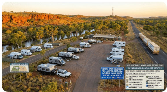
Victoria River Roadhouse Rest Area Free Camping — Senior Grey Nomad Guide 2026
Last updated: January 2026 | Victoria Highway, Northern Territory | Reading time ≈ 28 min
The Victoria River Roadhouse sits on one of the most visually dramatic stretches of highway in northern Australia. For thousands of grey nomads each dry season, it is the overnight stop between Katherine and the Western Australian border — a place to refuel, rest, and stare at ancient red escarpments while the sunset turns everything copper.
But there is more to know before you pull in with a 22-foot van or a 9-metre motorhome. Crocodile territory. Limited phone signal. Fuel gaps that punish the unprepared. Heat that turns a caravan into an oven by mid-morning if you have not planned your shade.
This guide covers everything a senior traveller needs — free camping options, paid caravan park comparison, road conditions in both directions, fuel logistics, water sources, dump points, wildlife hazards, accessibility notes, GPS coordinates you can save right now, and a printable checklist you can stick to your dashboard before you leave Katherine or Kununurra.
Every detail has been checked against 2026 NT government sources, roadhouse operator information, and reports from grey nomads who have stopped here in the last twelve months. If something has changed since your last trip through, you will find the update here.
Table of Contents
- Why Grey Nomads Stop at Victoria River Roadhouse
- Free Camping — Know the Limits for Seniors
- Your Two Main Options Side by Side
- Quick Facts and Key Details 2026
- How to Get to Victoria River Roadhouse
- Road Conditions, Flooding and Unsealed Sections
- Heat, Crocodiles and Remoteness — Seniors
- Wildlife — Birds, Reptiles and What to Watch For
- What Victoria River Roadhouse Doesn’t Tell You Online
- Best Time to Visit — Month-by-Month Breakdown
- Free and Low-Cost Camping Nearby
- Dump Points Near Victoria River Roadhouse
- Free Water Sources
- Fuel Stops Along the Victoria Highway
- Victoria River Roadhouse Caravan Park — Paid Alternative
- Full Facilities Comparison Table
- Rates — All Options Near Victoria River 2026
- The Victoria River Day Plan for Seniors
- Senior Checklist — Victoria Highway
- What to Do Near Victoria River — Senior Activity Guide
- GPS Coordinates and Postcodes — Save Every Stop
- Stargazing at Victoria River
- History of Victoria River Roadhouse
- Phone Signal and Emergency Communications
- Campfires and Cooking
- Pets at Victoria River Roadhouse
- Accessibility for Seniors with Mobility Limitations
- Camping Etiquette and Waste Management
- Emergency Scenarios — What to Do
- Packing List for This Section of Highway
- Rest Area Comparisons — Victoria Highway
- Permits and Park Fees
- Reviews — What Real Grey Nomads Say
- People Also Ask — Victoria River Roadhouse
- Frequently Asked Questions
- Quick-Reference Card
- Related Free Camping Guides — Victoria Highway
- 🗺️ Interactive Free Camp Finder Map
- Disclaimer
Why Grey Nomads Stop at Victoria River Roadhouse
Victoria River Roadhouse is not a destination you plan a holiday around. It is the logical overnight between two long stretches of empty highway — and that is precisely why it matters for seniors towing caravans or driving motorhomes.
Here is the arithmetic. Katherine to Kununurra is approximately 512 km on the Victoria Highway (National Highway 1). That is roughly six hours of towing at 85 km/h without stops. For most grey nomads, that is too long in a single day — particularly when afternoon fatigue and fading light increase accident risk on a road shared with road trains.
Victoria River Roadhouse sits almost exactly at the halfway mark, approximately 292 km west of Katherine and 220 km east of Kununurra. It offers fuel, food, cold drinks, toilets, and a place to park for the night — either free at the adjacent rest area or paid at the roadhouse’s own caravan park.
But the location offers something extra that grey nomads remember long after they leave: the view. The Victoria River cuts through ancient sandstone escarpments here, and the late-afternoon light on the red cliffs is one of the most photographed scenes on the entire Top End touring circuit. If you time your arrival for 3 pm and set up facing west, you will understand why people return year after year.
Free Camping — Looks Easy, But Know the Limits for Seniors
The free camping option at Victoria River is a designated roadside rest area managed by the Northern Territory Government (Department of Infrastructure, Planning and Logistics). It is located adjacent to the roadhouse, on the highway corridor.
The rest area is not the same as the roadhouse caravan park. The two are close together but have different rules, different facilities, and different expectations. Here is what you need to know:
Rules at the Free Rest Area
- Maximum stay: 24 hours (NT roadside rest area regulations)
- Fees: None — genuinely free
- Bookings: Not required, not possible
- Self-contained requirement: Not legally mandated at NT rest areas, but strongly recommended. There may be a basic toilet, but no showers, no power, no dump point
- Generators: Permitted but common courtesy applies — off by 9 pm, not before 7 am
- Fires: Ground fires prohibited in most conditions. Use your own contained gas stove or BBQ. Check current fire bans via the Bushfires NT website
- Grey water: Do not dump on the ground. Carry a grey water tank
What “Free” Actually Means Here
Free means no fee — but it does not mean fully serviced. You are parking on a gravel or hardstand area beside a major highway. Road trains will pass at all hours. Dust can be an issue when vehicles pull in and out. There is no camp host, no security, and no one monitoring arrivals.
For self-contained travellers with solar power, a full water tank, and a portable toilet, the rest area works perfectly well for an overnight stay. For seniors who need power for CPAP machines, reliable lighting, or level ground for mobility access, the paid caravan park next door may be the better choice — and it is still affordable.
Your Two Main Options Side by Side
| Feature | Free Rest Area | Victoria River Roadhouse Caravan Park |
|---|---|---|
| Cost | Free | From ~$20 unpowered / ~$38–$45 powered (2026 est.) |
| Power | No | Yes — powered sites available |
| Toilets | Basic (pit/drop toilet) — check condition on arrival | Yes — flushing toilets |
| Showers | No | Yes |
| Water | No potable water | Yes — tank fill available (may incur small charge) |
| Dump Point | No | Ask at roadhouse — limited facility |
| Fuel | Available at roadhouse (walk or short drive) | On-site — ULP, diesel, premium ULP |
| Food / Meals | BYO — roadhouse meals available for purchase | Restaurant/bar at roadhouse |
| Phone Signal | Telstra 4G (limited) | Telstra 4G (limited); WiFi may be available at bar |
| Max Stay | 24 hours | No limit (with payment) |
| Best For | Self-contained overnighters passing through | Seniors needing power, showers, or multi-night stays |
Quick Facts and Key Details 2026
| Detail | Information |
|---|---|
| Location Name | Victoria River Roadhouse Rest Area |
| Address | Victoria Highway (National Highway 1), Victoria River, NT 0852 |
| GPS Coordinates | -15.6083, 131.1364 |
| Coordinate Source | Google Maps / NT Government open data (publicly available) |
| Postcode | 0852 |
| LGA / Region | Victoria-Daly Regional Council |
| Highway | Victoria Highway (National Highway 1) |
| Road Surface | Fully sealed |
| Distance from Katherine | ~292 km west |
| Distance from Kununurra (WA) | ~220 km east |
| Distance from Timber Creek | ~92 km west |
| Fee | Free (rest area); Paid (caravan park) |
| Stay Limit (Rest Area) | 24 hours |
| Toilets | Basic at rest area; flushing at caravan park |
| Fuel Available | Yes — ULP, Diesel, Premium ULP at roadhouse |
| Phone Coverage | Telstra 4G (limited); Optus/Vodafone — nil/unreliable |
| Public WiFi | May be available inside roadhouse bar — check on arrival |
| Crocodile Risk | HIGH — saltwater crocodiles present in Victoria River |
| Best Season | May–September (dry season) |
How to Get to Victoria River Roadhouse — Directions from All Approaches
From Katherine (East) — 292 km
Leave Katherine heading west on the Victoria Highway (National Highway 1). The road is fully sealed and in good condition during the dry season. You will pass through relatively flat savanna woodland before the landscape begins to shift into dramatic sandstone country approaching the Victoria River crossing.
Key landmarks and stops along the way:
- Katherine township — last major supermarket, medical centre, Bunnings, and full-service fuel stations
- Flora River Nature Park turn-off — approximately 115 km from Katherine (unsealed access road, ~43 km off-highway)
- Victoria River Roadhouse — 292 km from Katherine
Allow 3.5–4 hours towing at comfortable highway speed. There is no fuel between Katherine and Victoria River Roadhouse — a 292 km gap. Ensure your tanks are full before leaving Katherine.
From Kununurra, WA (West) — 220 km
Leave Kununurra heading east on the Victoria Highway. You will cross the NT/WA border (note the time zone change — NT is UTC+9:30, WA is UTC+8, a 1.5-hour difference). Continue east through the border checkpoint area.
- Kununurra — full services including supermarkets, medical, fuel
- NT/WA Border — approximately 40 km east of Kununurra. Quarantine checkpoint — no fresh fruit, vegetables, honey, or certain plants into the NT
- Timber Creek — approximately 128 km from Kununurra, fuel and basic supplies available
- Victoria River Roadhouse — approximately 92 km east of Timber Creek (220 km from Kununurra)
Allow 2.5–3 hours towing. Fuel is available at Timber Creek, so the gap from Timber Creek to Victoria River is a manageable 92 km.
From the South (Top Springs / Buchanan Highway / Lajamanu Road)
The Buchanan Highway connects the Victoria Highway to the Tanami / Lajamanu Road system. The junction is approximately 80 km east of Victoria River Roadhouse. This road is unsealed and seasonal — it can be impassable in the wet season and rough even in the dry. Not recommended for caravans without 4WD capability and experience on outback roads. Check conditions before attempting.
From the North — No Direct Access
There is no sealed highway approaching Victoria River Roadhouse from the north. The Gregory National Park lies to the north, accessed via unsealed park roads. All highway traffic arrives from east or west on the Victoria Highway.
Road Conditions, Flooding and Unsealed Sections
Is the Road Sealed?
Yes. The Victoria Highway (National Highway 1) is fully sealed from Katherine to Kununurra, including the stretch past Victoria River Roadhouse. It is suitable for all conventional vehicles, caravans, and motorhomes during the dry season (May–October).
Does the Road Flood?
Yes — significantly. The Victoria Highway is subject to seasonal flooding between November and April (the wet season). Creek crossings and low-lying sections on both sides of Victoria River Roadhouse can be cut for days or even weeks after heavy monsoon rain.
Specific flood-prone sections include:
- Victoria River crossing itself
- Numerous creek crossings between Katherine and Victoria River
- Low-lying sections approaching Timber Creek
Road Trains
The Victoria Highway carries triple road trains up to 53.5 metres long. They travel at highway speed and create significant turbulence when passing. Senior drivers towing caravans should:
- Pull left and slow down when a road train approaches from either direction
- Allow at least 1 km of clear visibility before overtaking a road train
- Be prepared for sudden dust clouds if road shoulders are dry
- Never stop on narrow sections of highway — use designated pull-off bays
Rest Area Surface
The rest area parking surface is a mix of compacted gravel and hardstand. It is generally level but may have soft patches after rare dry-season showers. Motorhomes and caravans with standard ground clearance can access the area without difficulty. Check the surface before unhitching — walk it first if you have any doubt.
Heat, Crocodiles and Remoteness — What It Really Means for Seniors
Heat
Victoria River Roadhouse sits in the tropical savanna climate zone. Even during the “cooler” dry season (June–August), daytime temperatures routinely reach 32–36°C. In September–November (the build-up), temperatures can exceed 40°C with high humidity.
For seniors, this means:
- Dehydration risk — drink 3–4 litres of water per day minimum
- CPAP machines and medications stored in un-air-conditioned caravans can overheat. If you do not have air conditioning or cannot run it, consider the powered caravan park
- Set up in shade wherever possible. Natural shade is limited at the rest area
- Carry electrolyte supplements
- Avoid physical activity between 11 am and 3 pm
Crocodiles
The Victoria River is a confirmed saltwater crocodile habitat. Large crocodiles (4–5 metres) have been sighted and trapped in this section of the river. Freshwater crocodiles are also present but pose less danger to humans.
Crocodile safety rules — non-negotiable:
- Stay at least 5 metres back from any water’s edge
- Never camp within 50 metres of the river if possible
- Do not clean fish or discard food scraps near water
- Do not allow dogs near the river — they are high-value prey for saltwater crocodiles
- Be aware at dawn and dusk — crocodiles are most active in low light
- If you see a crocodile on land, move away slowly. Do not approach for photographs
Remoteness
The nearest hospital is in Katherine — approximately 292 km east, or roughly 3.5 hours by road. There is a small health clinic in Timber Creek (92 km west) with limited hours. The Royal Flying Doctor Service covers this area but response time depends on conditions and aircraft availability.
For seniors with chronic health conditions, ensure you:
- Carry at least two weeks’ worth of all medications
- Have a current medical summary accessible (not locked in your phone with no signal)
- Carry a personal locator beacon (PLB) or satellite communicator
- Know how to call 000 and describe your location using GPS coordinates
Wildlife at Victoria River — Birds, Reptiles and What to Watch For
The Victoria River corridor is one of the richest wildlife zones in the Top End. Even from the rest area, you are likely to see:
Birds
- White-bellied Sea-Eagle — commonly seen soaring along the river
- Whistling Kite — very common, often near the roadhouse looking for scraps
- Red-tailed Black-Cockatoo — large flocks feed in woodland near the river
- Rainbow Bee-eater — brilliantly coloured, often seen perched on fences
- Great Bowerbird — builds elaborate bowers near the caravan park area
- Budgerigars — large flocks in drier months
- Jabiru (Black-necked Stork) — occasionally seen along the river
Reptiles
- Saltwater Crocodile — resident in the Victoria River (see safety section above)
- Freshwater Crocodile — also present, generally not aggressive to humans
- Sand Monitor (Goanna) — commonly seen around the rest area scavenging
- Mertens’ Water Monitor — a beautiful semi-aquatic monitor found along the river
- King Brown Snake — present in the area. Watch where you step, especially at dusk
- Western Brown Snake — also present. Shake out shoes left outside overnight
Mammals and Invertebrates
- Agile Wallabies — often seen grazing near the roadhouse at dawn
- Dingoes — keep food secured, do not feed them
- Flying Foxes — large colonies roost in trees along the river
- March Flies and Mosquitoes — particularly fierce in the build-up season. Carry insect repellent and consider head nets for evening walks
What Victoria River Roadhouse Doesn’t Tell You Online
The roadhouse has a basic web presence and social media pages, but there are important things you will not find easily online:
- Fuel prices change frequently and are significantly higher than capital cities. Budget $2.40–$2.80 per litre for diesel in 2026. Pay at the pump or inside — check if card-only applies after hours
- The restaurant/bar has limited hours — typically breakfast, lunch and dinner but hours can change without notice. If you arrive late, you may find the kitchen closed. Carry backup meals
- Water fill is not always free — the roadhouse may charge a fee for filling large caravan tanks. Ask before connecting your hose
- The caravan park can fill up in peak season (July–August). While you do not typically need to book, arriving after 4 pm on a busy day may mean limited site choices
- Road train parking area is separate — make sure you park in the rest area or caravan park, not in the road train staging area
- ATM availability is limited — carry cash as a backup. EFTPOS may be available inside the roadhouse but connectivity issues can occur
Best Time to Visit Victoria River Roadhouse — Month-by-Month Breakdown
| Month | Avg Max °C | Rain | Road Status | Crowd Level | Senior Verdict |
|---|---|---|---|---|---|
| January | 37 | Heavy | Often closed | Very low | ❌ Avoid |
| February | 36 | Heavy | Often closed | Very low | ❌ Avoid |
| March | 36 | Heavy | Often closed | Very low | ❌ Avoid |
| April | 36 | Easing | May reopen late month | Low | ⚠️ Check road reports |
| May | 34 | Minimal | Open | Medium | ✅ Good — warm days, cool nights |
| June | 32 | Nil | Open | High | ✅ Best month |
| July | 31 | Nil | Open | Peak | ✅ Best month — busiest |
| August | 33 | Nil | Open | Peak | ✅ Excellent — arrive early for spots |
| September | 36 | Nil | Open | Medium | ⚠️ Getting hot — build-up starting |
| October | 38 | Building | Open | Low | ⚠️ Hot and humid — for experienced travellers only |
| November | 39 | Storms start | Risk of closure | Very low | ❌ Avoid |
| December | 38 | Heavy | Often closed | Very low | ❌ Avoid |
Free and Low-Cost Camping Near Victoria River Roadhouse
| Camp / Rest Area | Distance / Direction | Cost | Toilets | Notes |
|---|---|---|---|---|
| Victoria River Roadhouse Rest Area | On-site | Free | Basic | 24-hr limit; highway noise; croc country |
| Joe Creek Rest Area | ~50 km east | Free | Pit toilet | Shaded; smaller; quieter |
| Sullivan Creek Rest Area | ~80 km east | Free | Pit toilet | Roadside; basic shade |
| Big Horse Creek Rest Area | ~30 km west | Free | Pit toilet | Scenic; croc warning applies near waterways |
| Timber Creek — free camping area | ~92 km west | Free / donation | Yes | Near town; fuel available; police station nearby |
| Gregory National Park — various bush camps | 10–60 km (unsealed access) | $6.60/adult/night (NT Parks pass) | Varies by site | 4WD required for most sites; spectacular scenery |
Use the interactive map below to find and save all free camping spots along the Victoria Highway — including those not listed in official guides.
COPY PROMPT ➔ ASK AI ➔ SAVE TO FORM ➔ ADD SPOT PIN ➔ GET DIRECTIONS
📍 Interactive map — find free camps, rest areas and overnight stops. Enable location for best results.
Dump Points Near Victoria River Roadhouse
Dump point access is limited in this part of the NT. Here are your nearest options:
| Location | Distance | Free? | Notes |
|---|---|---|---|
| Victoria River Roadhouse Caravan Park | On-site | Ask — may be guest-only or fee applies | Availability varies — confirm at reception |
| Timber Creek | ~92 km west | Free (public) | Located near the town’s camping area |
| Katherine | ~292 km east | Free (multiple locations) | Katherine Low Level Caravan Park area; check council signage |
| Kununurra (WA) | ~220 km west | Free (public dump point) | Multiple caravan parks also offer dump points |
Free Water Sources Near Victoria River Roadhouse
Potable water is scarce along this section of the highway:
- Victoria River Roadhouse — water available for purchase or as part of caravan park stay. Ask at the roadhouse for tank fill access. A fee may apply for non-guests
- Timber Creek (92 km west) — town water supply available at some public taps. Check quality — NT outback town water can be bore water with high mineral content
- Katherine (292 km east) — full potable water access at caravan parks and some public taps
- Kununurra, WA (220 km west) — full potable water access
Fuel Stops Along the Victoria Highway — Complete Distance Table
Running out of fuel on the Victoria Highway is a genuine emergency, not just an inconvenience. There is no mobile coverage for long stretches, and tow truck response times are measured in hours (or days in the wet season).
| Fuel Stop | Direction from Vic River RH | Distance (km) | Fuel Types | Notes |
|---|---|---|---|---|
| Victoria River Roadhouse | — | 0 | ULP, Diesel, PULP | Open daily; check hours |
| Timber Creek | West | ~92 | ULP, Diesel | Small town; limited stock sometimes |
| Kununurra (WA) | West | ~220 | ULP, Diesel, PULP, LPG | Full-service town; multiple stations; competitive pricing |
| Katherine | East | ~292 | ULP, Diesel, PULP, LPG | Full-service town; cheapest fuel on this route |
| Top Springs (south) | South (via Buchanan Hwy) | ~185 (unsealed) | Diesel (limited ULP) | Unsealed road; not recommended for caravans; check stock before relying on it |
Victoria River Roadhouse Caravan Park — The Paid Alternative
The Victoria River Roadhouse Caravan Park is operated by the roadhouse and sits directly adjacent to the fuel station and restaurant. It is a basic outback caravan park — do not expect resort facilities — but it offers critical amenities that the free rest area does not.
What the Caravan Park Offers
- Powered sites — essential for seniors running CPAP machines, fans, or charging medical devices
- Unpowered sites — for self-contained travellers who want access to showers and toilets
- Showers — hot water; a luxury in this part of the world
- Flushing toilets
- Laundry — coin-operated or check with reception
- Restaurant and bar — meals served for breakfast, lunch and dinner (hours vary)
- Small shop / supplies — basics like bread, milk, ice, snacks, fishing supplies
- Ice — available for purchase (essential in this heat)
- Pool — check if operational; maintenance varies seasonally
Booking and Arrival
Bookings are generally not required but can be made by phoning the roadhouse directly — (08) 8975 0744 (verify current number on arrival). In peak season (July–August), arriving by 3 pm is recommended to secure your preferred site.
Full Facilities Comparison Table
| Facility | Free Rest Area | Roadhouse Caravan Park | Gregory NP Bush Camps |
|---|---|---|---|
| Toilets | Basic | ✅ | Pit/Drop |
| Showers | ❌ | ✅ | ❌ |
| Power | ❌ | ✅ | ❌ |
| Water | ❌ | ✅ | ❌ |
| Dump Point | ❌ | Ask | ❌ |
| Fuel | Nearby | On-site | ❌ |
| Meals | BYO | ✅ Restaurant | BYO |
| Phone Signal | Telstra (limited) | Telstra (limited) | None |
| Pets | On leash | Check rules | Not in National Park |
| Cost | Free | $20–$45/night | $6.60/adult/night |
Rates — All Options Near Victoria River Roadhouse 2026
Prices below are estimated for the 2026 dry season. Confirm directly with operators as rates can change.
| Option | Rate (2026 Est.) | Includes |
|---|---|---|
| Free Rest Area | $0 | Parking, basic toilet |
| Caravan Park — Unpowered | ~$20–$28 per night (2 adults) | Toilets, showers, access to restaurant |
| Caravan Park — Powered | ~$38–$45 per night (2 adults) | Power, toilets, showers, restaurant |
| Gregory NP Bush Camp | $6.60/adult/night (NT Parks pass) | Bush camping; basic facilities |
The Victoria River Day Plan for Seniors
Here is a comfortable itinerary for a senior couple stopping overnight at Victoria River Roadhouse:
| Time | Activity |
|---|---|
| 2:00 pm | Arrive. Choose your spot (rest area or caravan park). Set up in the shade if possible |
| 2:30 pm | Refuel at the roadhouse. Buy ice and cold drinks. Ask about water fill and dump point access |
| 3:00 pm | Rest in the shade. Hydrate. Check phone signal. Send a location update to family |
| 4:30 pm | Short walk (flat terrain near roadhouse — stay away from river). Photograph the escarpment in afternoon light |
| 5:30 pm | Sunset viewing. The escarpment glows copper-red — best viewed from the Victoria River bridge area (walk carefully, watch for traffic) |
| 6:00 pm | Dinner — either at the roadhouse restaurant or cook your own meal at your van |
| 7:30 pm | Stargazing — no light pollution. Bring a reclining camp chair and look up |
| 5:30 am | Wake. Coffee. Birdwatching from your camp chair |
| 6:30 am | Pack up and depart. Drive in the cool of the morning. Aim to reach your next stop before midday heat |
Senior Checklist — Victoria River Roadhouse and Victoria Highway
Before Departure:
- ☐ Full fuel tank (calculate range vs distance to next fuel stop)
- ☐ Jerry can filled if tank range is under 350 km towing
- ☐ Water tanks full — plus 20 L in separate containers
- ☐ Black/grey tanks emptied at last dump point
- ☐ Medications — 14-day supply minimum
- ☐ Medical summary printed (not just on phone)
- ☐ Check road conditions: roadreport.nt.gov.au
- ☐ PLB / satellite communicator charged
- ☐ CPAP battery backup if using free rest area (no power)
- ☐ Insect repellent and sunscreen
- ☐ Hat, long sleeves, sturdy shoes (snakes)
- ☐ Cash backup ($100 minimum)
- ☐ Emergency contact numbers written down (not just in phone)
- ☐ Walk the parking area before committing — check level, shade, soft spots
- ☐ Check toilet condition
- ☐ Check for crocodile warning signs — obey them
- ☐ Refuel at roadhouse
- ☐ Buy ice if needed
- ☐ Send location update to family/emergency contact
- ☐ Set up with awning facing afternoon shade if possible
- ☐ Leave the site cleaner than you found it
- ☐ Check tyre pressures (hot NT roads increase pressure)
- ☐ Confirm fuel level vs distance to next stop
- ☐ Check road conditions again before departing
- ☐ Depart early — aim to drive in the cool
What to Do Near Victoria River Roadhouse — Senior Activity Guide
1. Escarpment Lookout and Sunset Photography
The sandstone escarpments flanking the Victoria River are the main attraction. The view from the highway bridge and surrounding areas at sunset is spectacular. Flat walking — accessible for most seniors. Bring your camera or phone and a tripod for low-light shots.
2. Gregory National Park
Gregory National Park is the second-largest national park in the Northern Territory (over 12,800 km²). The Bullita and Limestone Gorge sections are accessed from Timber Creek (92 km west), but the eastern section of the park borders the Victoria River area. Activities include:
- Joe Creek Walk (short, accessible walk with gorge views)
- Scenic drives (some unsealed — check 4WD requirements)
- Bird watching and wildlife spotting
- Aboriginal rock art sites (check with NT Parks for access)
Note: Most of Gregory NP’s best features require 4WD and are not suitable for caravans. Day trips in a tow vehicle (unhitched) are feasible if roads are dry.
3. Victoria River Cruise
Seasonal boat cruises may operate on the Victoria River from the roadhouse or nearby launch points. These are a safe way to see the escarpments and spot crocodiles from a distance. Check with the roadhouse for current operator details and booking information — this service is not guaranteed every season.
4. Fishing (With Caution)
Barramundi fishing is popular in the Victoria River system. However, due to saltwater crocodile presence, you must:
- Never fish from the bank — use a boat
- Stand well back from the water’s edge
- Never clean fish at the water’s edge
- An NT fishing licence is required — purchase online at nt.gov.au/marine/recreational-fishing
5. Chat with Fellow Grey Nomads
Victoria River Roadhouse is a natural gathering point. The bar area in the evenings is where stories are shared, road condition intelligence is exchanged, and lifelong friendships begin. For solo seniors, this is a safe and welcoming community.
GPS Coordinates and Postcodes — Save Every Stop
| Location | Latitude | Longitude | Postcode | Source |
|---|---|---|---|---|
| Victoria River Roadhouse | -15.6083 | 131.1364 | 0852 | Google Maps (public) |
| Timber Creek | -15.6600 | 130.4730 | 0852 | Google Maps (public) |
| Katherine | -14.4524 | 132.2714 | 0850 | Google Maps (public) |
| Kununurra (WA) | -15.7736 | 128.7383 | 6743 | Google Maps (public) |
| Joe Creek Rest Area | -15.5550 | 131.5900 | 0852 | Approximate — verify on arrival |
| Big Horse Creek Rest Area | -15.6200 | 130.8800 | 0852 | Approximate — verify on arrival |
Stargazing at Victoria River Roadhouse
The Victoria River area has virtually zero light pollution outside the roadhouse itself. On a clear dry-season night (and almost every night between May and October is clear), the Milky Way is visible in breathtaking detail from horizon to horizon.
For senior travellers, this is a highlight that requires no physical effort:
- Set up a reclining camp chair away from the roadhouse lights
- Allow 15–20 minutes for your eyes to adjust to the dark
- The Southern Cross, Scorpius, and Sagittarius are particularly prominent
- Satellites and the International Space Station are frequently visible — use a free app like “Stellarium” or “Sky Tonight” (download before losing signal)
- A small pair of binoculars (7×50 or 10×50) will reveal nebulae and star clusters invisible to the naked eye
History of Victoria River Roadhouse
The Victoria River has deep significance for the Ngarinyman, Wardaman, and Karrangpurru Aboriginal peoples, who have lived along its banks for tens of thousands of years. The river was named by explorer Augustus Charles Gregory during his North Australian Exploring Expedition in 1855–56, in honour of Queen Victoria.
The Victoria River pastoral district became one of the great cattle regions of northern Australia in the late 19th and early 20th centuries. Victoria River Downs Station, one of the largest cattle stations in the world, operates nearby.
The roadhouse itself developed as a service point on the Victoria Highway during the post-war expansion of sealed roads across northern Australia. For decades it has been a critical fuel and rest stop for drovers, truckies, and — since the 1980s and 1990s — the growing grey nomad movement.
The adjacent Escarpment Walk and lookout areas offer a tangible sense of the geological age of this landscape — sandstone formations here date back hundreds of millions of years, long before the first humans arrived on the continent.
Phone Signal and Emergency Communications
| Network | At Roadhouse | On Highway (general) |
|---|---|---|
| Telstra 4G | Limited — 1–2 bars typical | Patchy. Drops out frequently between towns |
| Optus | No reliable coverage | No coverage |
| Vodafone / TPG | No reliable coverage | No coverage |
Emergency Options
- 000 calls: Will connect on any available network, including Telstra, even without a SIM. However, if there is no signal at all, 000 will not work
- Personal Locator Beacon (PLB): Works via satellite anywhere in Australia. Register yours at beacons.amsa.gov.au
- Satellite communicators: Garmin inReach, ZOLEO, or Spot devices provide two-way messaging via satellite where there is no phone signal. Highly recommended for the Victoria Highway
- UHF Radio: Channel 40 for general communications; roadhouse and truckies may monitor
- Roadhouse landline: The roadhouse has a landline phone. In a genuine emergency, the staff can assist with contacting services
Campfires and Cooking at Victoria River Roadhouse
- Ground fires: Generally prohibited at roadside rest areas in the NT. Total fire bans are common during the dry season due to savanna grassland fire risk
- Contained gas BBQs and camp stoves: Permitted. Use on a hard surface, clear of vegetation
- Firewood collection: Not permitted in rest areas or near the highway corridor
- Check current fire bans: securent.nt.gov.au/alerts
- Cooking at the caravan park: Camp kitchen or BBQ facilities may be available — check with the roadhouse
Pets at Victoria River Roadhouse
Many grey nomads travel with dogs. Here is what you need to know:
- Rest area: Dogs are generally permitted on a leash. No off-leash areas
- Caravan park: Check with the roadhouse — some roadhouse caravan parks allow dogs, others do not. Always confirm before booking
- Gregory National Park: Dogs are not permitted in NT national parks
- Crocodile risk: This is critical. Dogs are high-value prey for saltwater crocodiles. Never allow your dog near the Victoria River, any creek, or any body of water in this area. Keep your dog on a short leash at all times. Even 30 metres from the water’s edge is not necessarily safe at this location
- Cane toads: Cane toads are present in the Victoria River area. Dogs that mouth or lick cane toads can be poisoned — potentially fatally. If your dog is a curious breed, keep them inside after dark when toads are most active
- Heat: Dogs suffer in NT heat faster than humans. Ensure shade, water, and never leave a dog in a vehicle
Accessibility for Seniors with Mobility Limitations
Victoria River Roadhouse is a remote outback facility. Accessibility is limited compared to urban caravan parks:
- Rest area surface: Compacted gravel — navigable with a walker or standard wheelchair in dry conditions. May become uneven or soft after rain
- Toilets (rest area): Basic pit/drop toilet — unlikely to be wheelchair accessible. No grab rails
- Toilets (caravan park): More likely to have accessible facilities, but confirm with the roadhouse before arrival
- Showers (caravan park): May have a step-in shower recess. No guarantee of grab rails or shower seat
- Restaurant/bar: Generally accessible at ground level. Check for steps or ramps
- Walking paths: No formal walking paths from the rest area. The highway shoulder is the primary walking route — watch for traffic
Camping Etiquette and Waste Management
Outback rest areas survive on goodwill. Poor behaviour by a few travellers can lead to closures that affect everyone. Follow these principles:
- Take all rubbish with you. Bins at the rest area (if present) may be full or not regularly serviced. Carry your waste to the next town
- Do not dump grey water on the ground. Carry a grey water tank and empty it at a designated dump point
- Do not dump black water (toilet waste) anywhere except a designated dump point. This is illegal and creates a health hazard
- Keep noise down after 9 pm. Generators off. Music off. Conversations at considerate volume
- Do not take up more space than you need. Park considerately so others can fit
- Respect Aboriginal cultural sites. Do not remove rocks, artefacts, or disturb any cultural features
- Leave your site cleaner than you found it. Pick up any litter left by previous occupants if you can
Emergency Scenarios — What to Do
| Scenario | Action |
|---|---|
| Medical emergency (at roadhouse) | Call 000 if signal available. Alert roadhouse staff — they can use their landline. Activate PLB if no comms. RFDS will respond |
| Medical emergency (on highway, no signal) | Activate PLB immediately. Send satellite message if equipped. Stay with your vehicle. Flag down passing vehicles for assistance. Do NOT walk long distances in heat |
| Vehicle breakdown | Pull fully off the road. Display hazard signs. Stay with vehicle. Roadside assistance response times here are 6–24+ hours. Call/satellite message your roadside assist provider |
| Crocodile encounter | Move away slowly and calmly. Do not run. Do not turn your back. Get to higher ground. Report to roadhouse staff and NT Parks & Wildlife |
| Snakebite | Apply pressure bandage immediately (carry one). Do not wash the bite site. Immobilise the limb. Call 000 / activate PLB. Seek medical help ASAP — nearest is Timber Creek clinic (92 km) or Katherine Hospital (292 km) |
| Bushfire / grass fire | Do not drive through smoke. Turn around if safe. If trapped, stay in vehicle with engine running, windows up, air recirculation on. Lie below window level. Call 000 |
| Running out of fuel | Pull off road completely. Stay with vehicle. Flag passing vehicles. Truckies and grey nomads often carry spare fuel — ask politely. This is why you carry a satellite device |
Packing List for Victoria Highway — Seniors
- ☐ 20+ litres extra drinking water (per couple)
- ☐ Electrolyte sachets or tablets
- ☐ Pressure bandage (snakebite first aid)
- ☐ Insect repellent (DEET-based recommended)
- ☐ Sunscreen SPF 50+
- ☐ Wide-brim hat and long-sleeved shirts
- ☐ Sturdy closed-toe shoes (snakes, rough ground)
- ☐ Torch/headlamp with spare batteries
- ☐ PLB or satellite communicator
- ☐ UHF radio
- ☐ Paper road map (not just GPS — signal drops out)
- ☐ Cash ($100 minimum)
- ☐ Jerry can (fuel) — if tank range is borderline
- ☐ Spare tyre checked and inflated
- ☐ Tyre repair kit and 12V compressor
- ☐ Vehicle recovery strap (even for 2WD)
- ☐ 14+ days of all medications
- ☐ Printed medical summary
- ☐ Portable gas stove and spare gas canister
- ☐ Grey water container (if van doesn’t have built-in grey tank)
- ☐ Fly net / head net (march flies are aggressive)
- ☐ Binoculars (birding and wildlife)
- ☐ Camera or phone with charged battery
- ☐ Reclining camp chair (stargazing and sunset viewing)
Rest Area Comparisons — Victoria Highway
How does Victoria River Roadhouse Rest Area compare to other stops on the Victoria Highway?
| Rest Area | Fuel Nearby | Toilets | Shade | Scenic | Croc Risk | Best For |
|---|---|---|---|---|---|---|
| Victoria River RH Rest Area | ✅ (on-site) | Basic | Limited | ⭐⭐⭐⭐⭐ | HIGH | Overnighters; sunset; fuel |
| Joe Creek Rest Area | ❌ | Pit | Good | ⭐⭐⭐ | Moderate | Quieter alternative |
| Sullivan Creek Rest Area | ❌ | Pit | Some | ⭐⭐ | Low–Mod | Basic stop; long-haul break |
| Big Horse Creek Rest Area | ❌ | Pit | Some | ⭐⭐⭐ | Moderate | Scenic; smaller groups |
Permits and Park Fees
- Victoria River Roadhouse Rest Area: No permit required. No fee
- Victoria River Roadhouse Caravan Park: Pay at roadhouse reception. No advance permit needed
- Gregory National Park: An NT Parks Pass is required for camping. Purchase online at nt.gov.au/parks-reserves or at Parks offices in Katherine. 2026 rates are approximately $6.60 per adult per night for basic bush camping
- Aboriginal Land: Some areas adjacent to the Victoria Highway are Aboriginal land under the Aboriginal Land Rights (Northern Territory) Act 1976. Do not leave the highway corridor or enter Aboriginal land without a permit from the relevant Land Council (Northern Land Council)
- NT Fishing Licence: Required if fishing. Purchase online before you lose phone signal
Reviews — What Real Grey Nomads Say About Victoria River Roadhouse
Based on publicly available reviews from WikiCamps, Google, and grey nomad forums (2024–2026 posts):
People Also Ask — Victoria River Roadhouse
Is Victoria River Roadhouse still open in 2026?
Yes. As of early 2026, Victoria River Roadhouse continues to operate as a fuel station, restaurant/bar, and caravan park. The roadside rest area adjacent to it remains open for free overnight camping. Operating hours and services may vary — phone ahead if arriving outside standard hours (approximately 6 am – 9 pm).
How far is Victoria River Roadhouse from Darwin?
Approximately 604 km via the Stuart Highway and Victoria Highway, through Katherine. Allow 7–8 hours towing a caravan. Most grey nomads split this into two days with an overnight stop in Katherine.
Can I get LPG at Victoria River Roadhouse?
LPG availability is not guaranteed at Victoria River Roadhouse. The nearest reliable LPG is typically Katherine (east) or Kununurra (west). Fill your LPG bottles at a major centre before travelling this section.
Is there a mechanic at Victoria River Roadhouse?
There is no permanent mechanic on site. Basic automotive supplies may be available in the roadhouse shop. For breakdowns, contact your roadside assistance provider — response times are lengthy in this area (6–24+ hours). The nearest mechanical workshops are in Katherine and Kununurra.
Are there crocodile-free swimming spots near Victoria River Roadhouse?
There are no guaranteed crocodile-free natural swimming spots in the Victoria River area. All waterways in this region should be treated as containing saltwater crocodiles. Some roadhouses and caravan parks have pools — check if the Victoria River Roadhouse pool is operational during your visit.
Frequently Asked Questions
Is camping free at Victoria River Roadhouse rest area?
Yes. The roadside rest area adjacent to the Victoria River Roadhouse on the Victoria Highway is free for self-contained travellers. There is no booking and no fee. The roadhouse itself also operates a paid caravan park with powered and unpowered sites.
Can I swim in the Victoria River?
No. The Victoria River contains saltwater crocodiles year-round. Swimming, wading, fishing from the bank edge, or allowing pets near the water is extremely dangerous. Observe all crocodile warning signs.
Is there phone signal at Victoria River Roadhouse?
Telstra provides limited 4G coverage at and around the roadhouse. Optus and Vodafone have no reliable coverage. A Telstra pre-paid SIM or satellite communicator such as a Garmin inReach is recommended.
How far is the nearest fuel from Victoria River Roadhouse?
Heading west toward Kununurra, Timber Creek is approximately 92 km away. Heading east toward Katherine, the next fuel is at Katherine itself, roughly 292 km away. Always carry sufficient fuel reserves.
Does the Victoria Highway flood?
Yes. The Victoria Highway is subject to seasonal flooding and closures during the wet season (November–April). Creek crossings and low-lying sections between Timber Creek and Katherine can become impassable. Always check NT road conditions at roadreport.nt.gov.au before travelling.
Are dogs allowed at the Victoria River Roadhouse rest area?
Dogs are generally permitted at the roadside rest area provided they are on a leash and under control. However, due to crocodile risk, dogs must never be allowed near the river. Check with the roadhouse for rules applying to the paid caravan park.
Is the road sealed to Victoria River Roadhouse?
Yes. The Victoria Highway (National Highway 1) is fully sealed between Katherine and Kununurra, including the section passing Victoria River Roadhouse. The road is suitable for conventional vehicles, caravans and motorhomes in the dry season.
Quick-Reference Card — Victoria River Roadhouse
| 📍 Location | Victoria Highway, Victoria River, NT 0852 |
| 🧭 GPS | -15.6083, 131.1364 |
| 💰 Cost | Free (rest area) | $20–$45 (caravan park) |
| 🚿 Showers | Caravan park only |
| 🚽 Toilets | Basic (rest area) | Flushing (caravan park) |
| ⛽ Fuel | ULP, Diesel, PULP at roadhouse |
| ⛽ Next Fuel East | Katherine — 292 km |
| ⛽ Next Fuel West | Timber Creek — 92 km |
| 📶 Phone | Telstra 4G (limited) |
| 🐊 Croc Risk | HIGH — saltwater crocodiles confirmed |
| 🗓️ Best Season | May–September |
| ⏱️ Max Stay (Rest Area) | 24 hours |
| 📞 Roadhouse Phone | (08) 8975 0744 (verify current) |
| 🆘 Emergency | 000 (if signal) | PLB | Satellite messenger |
Related Free Camping Guides — Victoria Highway and NT
Continue your trip planning with these related guides:
- Timber Creek Free Camping — Grey Nomad Guide 2026
- Katherine Low Level Free Camping — Senior Guide 2026
- King River Rest Area Free Camping — Grey Nomad Guide 2026
- Gregory National Park Camping Guide for Seniors 2026
- Kununurra Free Camping and Rest Areas — Grey Nomad Guide 2026
- Stuart Highway Free Camps — Katherine to Alice Springs 2026
- Great Northern Highway Free Camps — Kununurra to Broome 2026
Disclaimer
This guide is provided for informational purposes only and was current at the time of writing (January 2026). Conditions, facilities, fees, road status, and regulations can change without notice. Always verify information with official sources before travelling, including:
- NT Road Report — current road conditions and closures
- NT Parks and Wildlife — park fees, camping permits, fire bans
- Secure NT — emergency alerts and fire bans
The authors are not liable for any loss, injury, or damage arising from the use of this information. Travel in remote Australia at your own risk. Ensure you are adequately prepared, insured, and equipped for outback conditions. Crocodile warnings in this guide reflect genuine and ongoing safety risks — treat them seriously.
Free campsites and powered sites fill fast during school holidays and peak season. If your preferred site is already gone, search remaining accommodation options below to explore the region.
Accommodation and flight search powered by Expedia. Booking through this search supports this website at no extra cost to you. As an affiliate, I earn from qualifying purchases at no extra cost to you.

As an affiliate, I earn from qualifying purchases at no extra cost to you.
As an affiliate, I earn from qualifying purchases at no extra cost to you.