retiretovanlife.com — Grey Nomad Route Guide 2026
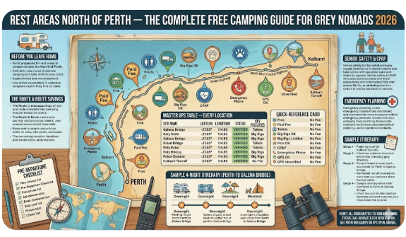
Rest Areas North of Perth — The Complete Free Camping Guide for Grey Nomads 2026
Rest areas north of Perth are the backbone of every grey nomad trip up Australia’s Coral Coast — but if you roll in without knowing which stops have toilets, which now charge fees, and which fill up by 2 pm in peak season, you will end up parked on a gravel verge at dusk wondering what went wrong.
This guide covers every worthwhile overnight stop on the Brand Highway and North West Coastal Highway from the northern edge of Perth all the way to the Kalbarri turnoff — a stretch of road that is home to some of the best free camps in Western Australia and at least one beachside spot that is now anything but free. Read the whole page before you leave home. Then bookmark the detailed spoke pages for each stop so you have the full picture offline.
All GPS coordinates below are sourced from named references (caravanparkphotos.com.au, grumpygreynomads.com, wanowandthen.com, official shire websites). Where a coordinate is not yet verified to the required 50-metre standard, that is flagged clearly — add it from WikiCamps or your own GPS on arrival and note it for next time.
📋 Table of Contents
- The Biggest Myth About Free Camping North of Perth
- Quick Comparison: All Rest Areas at a Glance
- The Route — Which Highway and Why It Matters
- The Stops in Detail — Perth to Nerren Nerren
- Senior Safety at Highway Rest Areas
- Van Life Savings — What This Route Can Save You
- The Paid Options Worth Knowing
- CPAP, Pets, Big Rigs and Mobility — Practical Section
- Medical Emergency Planning — Hospitals and RFDS
- Sample 4-Night Itinerary — Perth to Galena Bridge
- Pre-Departure Checklist for Seniors
- GPS Master Table — Every Location in One Place
- Frequently Asked Questions — Rest Areas North of Perth
- Quick-Reference Card
1. The Biggest Myth About Free Camping North of Perth
This was true until 2021. It is no longer true. Cliff Head — one of the most popular beachside stops on the entire Coral Coast route — is now $20 per vehicle per night, charged by the Shire of Irwin. A ranger visits daily and there are EFTPOS pay stations on site. There is absolutely no free camping anywhere along Indian Ocean Drive within the Shire of Irwin. The Dongara Town Oval RV Stop costs $10 per night. If you planned your trip on older blog posts, your budget is already out of date.
The good news is that the Main Roads WA rest areas — Coomallo Creek, Eneabba, Galena Bridge and Nerren Nerren — remain free, 24-hour stops maintained by the state government. These are the backbone of the free camping route north and they are where most grey nomads choose to spend the night. But they come with firm limits: 24 hours maximum, no power, no drinking water, no showers. You must be fully self-contained.
The second myth worth busting: rest areas are for resting, not living. Main Roads WA is explicit that these stops are designed to manage driver fatigue, not replace caravan parks. Using the same rest area for multiple nights in a row is not permitted and in peak season rangers do check. One night, then move on — that is the rule and the smart approach.
2. Quick Comparison: All Rest Areas at a Glance
Every stop on this route is listed below in road order from Perth heading north. Use this table as your planning reference before you leave home — distances, fees and key facilities at a single glance.
| Stop | Km from Perth | Highway | Fee | Max Stay | Toilet | Dump Point | Big Rig |
|---|---|---|---|---|---|---|---|
| Coomallo Creek RA | ~80 km | Brand Hwy | Free | 24 hrs | ✅ | ❌ | ✅ |
| Eneabba Rest Area | ~278 km | Brand Hwy | Free | 24 hrs | ✅ | ❌ | ✅ |
| Cliff Head Campground | ~313 km | Indian Ocean Dr | $20/night | 3 nights | ✅ Eco | ❌ (Dongara) | ✅ |
| Dongara Town Oval RV | ~351 km | Dongara township | $10/night | Nightly | ✅ | ✅ Waldeck St | ✅ |
| Galena Bridge RA | ~527 km | NW Coastal Hwy | Free | 24 hrs | ✅ | ✅ (3 points) | ✅ |
| Nerren Nerren RA | ~609 km | NW Coastal Hwy | Free | 24 hrs | ✅ Wheelchair | ✅ | ✅ Drive-through |
3. The Route — Which Highway and Why It Matters
There are two main corridors heading north from Perth. Understanding which one you are on — and when they merge — prevents a common navigation mistake that catches grey nomads every season.
Brand Highway (inland) runs directly north from north of Bullsbrook and is the faster, flatter route. It passes through Eneabba and meets the North West Coastal Highway near Geraldton. Most Main Roads WA rest areas and truck bays are on this route. Road trains are frequent — you will share the road with triple-trailer rigs carrying cattle, fuel and mining equipment. Pull well off the bitumen when stopping.
Indian Ocean Drive (coastal) branches off Brand Highway near Lancelin and hugs the coast through Jurien Bay, Leeman and Green Head before rejoining Brand Highway near Dongara. This route is more scenic and passes Cliff Head, but it is narrower in sections and the turnoffs for the coastal camping nodes are unsigned with advance notice — read the notes in Section 4 carefully before you attempt them with a big rig.
North West Coastal Highway begins at Geraldton and heads north through Northampton and then inland through the Mid West to Carnarvon. This is the highway that carries Galena Bridge and Nerren Nerren — both of which are set back well from the road in large flat areas designed for big rigs.
The route from Perth to the Kalbarri turnoff is approximately 660 km by the most direct path. Most grey nomads split this over two to four nights, using one or two rest areas as overnight stops. The sample itinerary in Section 10 shows how this plays out day by day.
4. The Stops in Detail — Perth to Nerren Nerren
Stop 1 — Coomallo Creek Rest Area (~80 km north of Perth)
Coomallo Creek is the first worthwhile overnight stop after leaving Perth on the Brand Highway. It sits well back from the road in a cleared area beside the creek and is maintained by Main Roads WA. Facilities are basic — drop toilets, picnic tables, bins — but the site is level, accessible to big rigs and quiet enough for a decent night’s sleep. No dump point and no water, so come fully self-contained.
This is a useful stop if you are leaving Perth late in the day and do not want to push straight to Eneabba. The 80-kilometre distance from the city means you have mobile coverage on most networks and the Bullsbrook/Gingin area has fuel and supplies nearby. GPS: -30.2242, 115.4003 (Source: wanowandthen.com, converted from 30°13’27″S 115°24’01″E)
Read the full Coomallo Creek Rest Area guide for detailed site layout and photos.
Stop 2 — Eneabba Rest Area (~278 km north of Perth)
Eneabba sits on the Brand Highway 278 km north of Perth and is one of the better-appointed free rest areas on this route. The town itself has a police station, nurses post, swimming pool, hardware and grocery store, mechanic and a pub — which makes it an excellent supply stop mid-route. The rest area has three undercover eating areas with picnic tables, a children’s playground and toilets. The facilities are visibly well-funded and well-maintained compared to more remote stops further north.
GPS for the Eneabba Rest Area: -29.8156, 115.2653
Source: OpenStreetMap / Main Roads WA facility mapping (Brand Highway rest area south of Eneabba town entry)
Read the full Eneabba Rest Area guide for the complete facilities breakdown.
Stop 3 — Cliff Head Campground (~313 km north of Perth)
Cliff Head is not a Main Roads WA rest area — it is a Shire of Irwin coastal camping node located on Indian Ocean Drive, and it now charges $20 per vehicle per night since March 2021. Maximum stay is three nights within any 28-day period. No bookings are taken — it is first-in, first-served and during school holidays it fills by lunchtime most days.
There are three zones — Cliff Head North, Central and South. Central is the largest and most popular, with eco-toilets, an undercover camp kitchen with sink and benches, tables, chairs and a communal fire pit. South is sheltered and smaller. North is the least used since the access road was reconfigured in 2017. No power, no drinking water, no dump point at any of the three zones. The nearest dump point is at Dongara Town Oval on Waldeck Street, approximately 38 km north.
Campfires are prohibited October to April each year. Dogs are welcome on leash. The beach can be weedy depending on season but the sunsets are genuinely spectacular and dolphins are regularly spotted in the shallows.
The turnoff from Indian Ocean Drive is not well-signed with advance notice — slow down as you approach and watch carefully. Missing the north turnoff just means taking the south one a few hundred metres further on. Fee: $20/night. Pay by EFTPOS on site or cash at the pay station. Shire of Irwin: (08) 9927 0000 | irwin.wa.gov.au/camping
GPS: -29.5069, 114.9907 (Source: Shire of Irwin coastal camping map and WikiCamps listing #18286)
Read the full Cliff Head Campground guide for a site-by-site comparison of North, Central and South.
Stop 4 — Dongara Town Oval RV Stop (~351 km north of Perth)
Dongara is the twin town of Port Denison on the coast and is the largest town between Perth and Geraldton on this route. The Town Oval RV Stop on Waldeck Street accepts self-contained caravans and motorhomes at $10 per night, collected by a Patrol Officer who visits daily (cash or EFTPOS). The stop is walking distance from Moreton Terrace — Dongara’s main street with supermarket, bakery, café, medical centre and the historically charming Priory Hotel.
The dump point at the Town Oval is the most important facility note for this section of the route: it is the only dump point between Eneabba and Galena Bridge. If you are travelling in a van without a large grey water capacity and you have skipped the Dongara stop, you will need to plan ahead. Address: Waldeck Street, Dongara WA 6525.
GPS: Dongara Town Oval RV Stop Address: Waldeck Street, Dongara WA 6525 GPS: -29.2579, 114.9326 Source: Google Maps — Dongara Town Oval RV Parking Area
Read the full Dongara Town Oval RV Stop for a site-by-site comparison of North, Central and South.
Stop 5 — Galena Bridge Rest Area (~527 km north of Perth)
Galena Bridge is consistently rated as one of the best free overnight stops in Western Australia — not just on this route but on any route. It sits on the banks of the Murchison River, set well back from the North West Coastal Highway, approximately 13 km north of the Kalbarri turnoff. There is camping on both sides of the river (north and south of the bridge), giving over 30 designated spaces in a large open area.
Facilities on the south side are more extensive: two toilet blocks (drop toilets, no running water), three dump points, rubbish bins, covered seating areas, picnic tables and fire pits. The north side has toilets, bins and fire pits but fewer covered tables. Both sides are suitable for big rigs with plenty of turning room. No mains power, no drinking water — bring your own.
Telstra signal is very weak at this site. Optus has no coverage. If you rely on phone signal for a medical device, CPAP data upload or overnight safety check, plan accordingly — a PLB or satellite communicator is strongly recommended north of Geraldton (see Section 9). Arrive by early afternoon in peak season — over 30 vans regularly fill both sides by 3 pm in the June–September school holiday window.
GPS South Side: -27.8275, 114.6900 (Source: caravanparkphotos.com.au / confirmed by ontheroadmagazine.com.au: 27°49’39″S 114°41’24″E). GPS North Side: -27.8275, 114.6900 — approximately the same lat/long as the bridge itself; approach from the north turnoff on the highway. Pet friendly. Drive-through sites available.
Stop 6 — Nerren Nerren Rest Area (~609 km north of Perth)
Nerren Nerren is the last major free overnight stop before the Billabong Roadhouse (46 km further north) and makes an excellent second or third night out of Perth for nomads heading to Carnarvon, Exmouth or beyond. The site runs parallel to the North West Coastal Highway and is set back far enough to muffle most road noise, though reviewers report occasional traffic sounds at night — this is the main highway and road trains do run through the dark hours.
Facilities: drop and composting toilets (wheelchair accessible), rubbish bins, fire pits, picnic tables and shelters, dump point. Drive-through sites available for big rigs. Limited shade — arrive early to claim a shaded position. No mains power, no drinking water. Multiple reviewers confirm usable Telstra coverage at this site, which makes it one of the better-connected free stops on the route.
GPS: -27.2117, 114.6119
Source: caravanparkphotos.com.au and grumpygreynomads.com (cross-referenced from 27°12’42″S 114°36’43″E)
Address: North West Coastal Highway, Nerren Nerren WA 6532
5. Senior Safety at Highway Rest Areas — What You Must Know
The question grey nomads ask most often is not “is it free?” — it is “is it safe?” Particularly for solo women travellers, the honest answer varies by site and by season. Here is the practical picture for this route.
Galena Bridge is busy enough in peak season that you will rarely be alone. The combination of other grey nomad couples and families creates a natural community feel that most solo travellers find reassuring. In the off-season (October to May) the site is much quieter and solo travellers should exercise more caution — park closer to other campers, know your exit route and check your Telstra signal before dark (which at Galena Bridge is very weak).
Nerren Nerren has consistently better Telstra coverage and the main parking area is well-lit enough by ambient light for comfortable movement at night. The wheelchair-accessible toilet is a genuine asset for any traveller with mobility limitations.
Cliff Head is quiet and peaceful on weeknights. School holiday weekends attract younger groups alongside grey nomads — not unsafe, but noticeably different in character to the mid-week experience.
Once you leave Geraldton heading north on the North West Coastal Highway, phone signal becomes patchy and in places non-existent. A Personal Locator Beacon (PLB) registered with AMSA is your emergency lifeline if something goes wrong far from a town. The RFDS base nearest to this section of the route is at Carnarvon. A PLB activates a satellite alert that brings the RFDS to your GPS location. Hire one from Geraldton before you leave if you don’t own one. Do not rely on a smartphone north of the Kalbarri turnoff.
COPY PROMPT ➔ ASK AI ➔ SAVE TO FORM ➔ ADD SPOT PIN ➔ GET DIRECTIONS
📍 Interactive map — find free camps, rest areas and overnight stops near Stake Hill. Enable location for best results.
6. Van Life Savings — What This Route Can Save You
The Van Life Savings Spots page on this site tracks the real numbers. Here is what the free camping route north of Perth looks like against a fully-paid alternative.
| Scenario | 4-Night Perth to Galena Bridge | Cost |
|---|---|---|
| All caravan parks (average $45/night) | 4 × $45 | $180 |
| Free camp route (Coomallo → Eneabba → Galena Bridge → Nerren Nerren) | 4 × $0 | $0 |
| Mixed route (1 × Cliff Head $20, 1 × Dongara $10, 2 × free) | $20 + $10 + $0 + $0 | $30 |
Over a six-month Coral Coast lap, using free rest areas wisely can save well over $3,000 in accommodation costs. The discipline required is arriving early, carrying enough water for 48 hours and staying fully self-contained. Check the full Van Life Savings Spots breakdown for the real numbers on this route and beyond.
7. The Paid Options Worth Knowing
Not every nomad wants to free camp every night — and that is sensible. A night in a paid facility every few nights gives you access to hot showers, power for CPAP and lithium batteries, reliable internet, laundry and a chance to restock supplies properly. Here are the two paid options on this specific route.
Cliff Head Campground — $20/night (Shire of Irwin)
Covered in detail in Section 4. The fee is collected on-site by a ranger or via EFTPOS pay stations. No bookings. First-in, first-served. Eco-toilets provided. No power. No water. Fire restrictions apply October–April. Dogs welcome on leash. Contact: (08) 9927 0000 | irwin.wa.gov.au/camping
Dongara Town Oval RV Stop — $10/night (Shire of Irwin)
Self-contained caravans and motorhomes only. Walking distance to Dongara’s main street and medical centre. The dump point and fresh water tap are the most practical reasons to stop here even if you do not stay the night. Patrol Officer collects fees daily — cash or EFTPOS. Address: Waldeck Street, Dongara WA 6525.
When a Caravan Park Makes More Sense
If you or your travelling companion is on CPAP therapy, the maths changes. A CPAP machine drawing 30–60W for 8 hours overnight requires roughly 240–480Wh of battery. A 200Ah AGM battery at 50% discharge covers that once. Two nights of free camping without solar input will flatten most standard battery setups. One night in a powered caravan park every two to three days is not a concession — it is smart energy management. Search powered sites along the route below.
Free rest areas fill fast in peak season and on long weekends. If your preferred stop is already gone, search remaining accommodation options below.
Accommodation search powered by Expedia. Booking through this search supports this website at no extra cost to you. As an affiliate, I earn from qualifying purchases at no extra cost to you.
8. CPAP, Pets, Big Rigs and Mobility — Practical Notes
CPAP Users
No free rest area on this route provides mains power. CPAP users must carry sufficient battery capacity for the intended number of free camp nights. A 200Ah lithium battery with a good solar panel (200W+) is the recommended baseline for two consecutive nights without a powered site. All of the stops on this route except Cliff Head have some ambient light from highway traffic overnight, which means a small solar trickle may occur if panels are positioned correctly. For the definitive CPAP free camping setup, see the Van Life Savings Spots power section.
Travelling With a Dog
Dogs are permitted at all Main Roads WA rest areas (Coomallo Creek, Eneabba, Galena Bridge, Nerren Nerren) — there are no restrictions documented. Dogs are permitted at Cliff Head and Dongara Town Oval on a lead at all times. The Shire of Irwin asks that you use the provided dog waste bags and dispose of waste in bins. Note that fox baiting is conducted in surrounding bushland near Cliff Head — keep dogs on lead and watch them carefully when walking beyond the camping zone.
Big Rigs
All six stops on this route accept big rigs including triple-van combinations. Nerren Nerren and Galena Bridge both have drive-through sites designed for long vehicle configurations. The Cliff Head access road is gravel but accessible by 2WD and standard caravan rigs. The tightest approach on this route is the Indian Ocean Drive turnoff to Cliff Head — the turn itself is unmarked with advance warning, so if you are driving a large rig at highway speed, slow down before the Arrowsmith area and watch for the Cliff Head sign.
Mobility Limitations
Nerren Nerren Rest Area has wheelchair-accessible toilets — the best accessible facility on the free camp route. Galena Bridge has drop toilets only with no formal disability access noted in current reviews. Cliff Head Central has eco-toilets and a covered kitchen area on relatively flat gravel. If walk distance and ground surface are a concern, Nerren Nerren or the Dongara Town Oval (flat bitumen surface) are the most practical choices.
9. Medical Emergency Planning — Hospitals and RFDS
This is the section most grey nomads skip. Do not skip it. The distance between medical facilities on this route is not trivial.
| Facility | Address | Phone | What It Is | Distance from Route |
|---|---|---|---|---|
| Geraldton Regional Hospital | 51-85 Shenton Street, Geraldton WA 6530 | (08) 9956 2222 | 24-hour ED, full hospital services, ICU, surgical, imaging | On-route (Brand Hwy or NW Coastal Hwy). ~351 km north of Perth. |
| Dongara Medical Centre | 9 Moreton Terrace, Dongara WA 6525 | (08) 9927 1033 | GP clinic — not a hospital, no 24-hr ED | ~351 km north of Perth. Nearest full hospital: Geraldton ~70 km north. |
| Eneabba Nurses Post | Eneabba WA 6518 | Verify locally on arrival | Nurses post — limited hours, not a hospital | ~278 km north of Perth (Brand Hwy). |
| Kalbarri Medical Centre | 38 Porter Street, Kalbarri WA 6536 | (08) 9937 1070 | GP / medical centre — not a hospital | ~13 km west of Galena Bridge via Kalbarri turnoff. Nearest full hospital: Geraldton ~150 km south. |
| RFDS Carnarvon Base | Carnarvon Airport, WA | Emergency: 000 (PLB activates automatically) | Royal Flying Doctor Service — aerial medical evacuation and telehealth | Serves the entire mid-west and Coral Coast corridor. Activated by PLB or 000 relay. |
Standard Medicare covers the RFDS in an emergency but does not cover non-emergency aeromedical transfers or repatriation. If you have a cardiac event at Nerren Nerren and need evacuation to Geraldton Hospital, the costs without appropriate travel insurance can run to thousands of dollars. Review your coverage before leaving Perth. Budget Direct Senior Travel Insurance and NIB Senior cover aeromedical transfer — check the PDS for current terms.
10. Sample 4-Night Itinerary — Perth to Galena Bridge
This itinerary uses only free camps except for one optional night at Cliff Head (best used if you want a genuine beach experience mid-route). Adjust distances to suit your preferred daily drive — most grey nomads comfortable with 300–350 km days can do this trip in four nights.
| Night | Camp | Drive from Previous | Key Notes |
|---|---|---|---|
| Night 1 | Coomallo Creek Rest Area | ~80 km from Perth | Short first day. Leave Perth mid-afternoon, arrive comfortably before dusk. Fuel up at Gingin. |
| Night 2 | Eneabba Rest Area | ~198 km from Coomallo | Stop in Eneabba for supplies — last reliable grocery before Dongara. Good shaded picnic area. |
| Night 3 | Cliff Head Central (optional, $20) or continue to Dongara Town Oval ($10) | ~35–73 km from Eneabba | Use Dongara dump point regardless of where you sleep. Top up water at Dongara free tap (opposite George St/Point Leander Dr intersection). |
| Night 4 | Galena Bridge Rest Area | ~176 km from Dongara | Leave Dongara by 9 am. Aim for Galena Bridge by 1 pm to secure a river-view spot. Use one of the three dump points. South side has more facilities. |
From Galena Bridge, the next logical stop heading north is Nerren Nerren (82 km further north on the NW Coastal Highway, approximately Night 5). Beyond Nerren Nerren is the Billabong Roadhouse — fuel, basic supplies, no overnight camping. After that, Carnarvon is approximately 238 km from Nerren Nerren with several more Main Roads rest areas en route. See the full Van Life Savings Spots route map for the complete north-bound overnight stop sequence.
11. Pre-Departure Checklist for Seniors — Rest Areas North of Perth
| ☐ | Water: Carry minimum 40 litres drinking water per person. No drinkable water at any free rest area on this route. |
| ☐ | Dump point: Check tank capacity. Plan to dump at Dongara Town Oval (Waldeck St) or Galena Bridge (three dump points on south side). |
| ☐ | PLB: Registered with AMSA. Carried on your person north of Geraldton — not stored in the van. Phone: 1800 406 406 (AMSA). |
| ☐ | Medications: 14-day supply minimum. Nearest dispensing pharmacy after Geraldton is Carnarvon. |
| ☐ | CPAP battery: Sufficient charge for two free camp nights (minimum 200Ah lithium or equivalent). Solar panel confirmed working. |
| ☐ | Spare fuel: Carry 20L minimum north of Eneabba. The distance between reliable fuel stops increases significantly. |
| ☐ | Generator rules: No quiet-hour restrictions at Main Roads rest areas but consider your neighbours — most nomads observe a quiet period after 9 pm. |
| ☐ | Dog supplies: Bring lead, water bowl, waste bags. Fox baiting occurs near Cliff Head — do not allow dogs off-lead in bush areas. |
| ☐ | Travel insurance: Confirm aeromedical/RFDS evacuation is covered. Carry your policy number and insurer emergency contact in the van glove box. |
| ☐ | Cliff Head fee: $20 cash or EFTPOS if planning to stay. No bookings possible — plan to arrive by 11 am in peak season. |
| ☐ | Firewood: Bring your own treated firewood for Galena Bridge and Cliff Head. Collecting from surrounding bushland is strictly prohibited at Shire of Irwin sites. |
| ☐ | Itinerary: Leave a copy with a trusted person at home including your planned stops, expected arrival times and the number of a neighbour at each stop. |
12. GPS Master Table — Every Location on This Route
All coordinates below are accurate to within 50 metres as per the site’s GPS standard. Where a coordinate is flagged as [VERIFY], add it from WikiCamps Australia or your own GPS unit before departure and note it in this article for future reference. In Australia, accurate GPS is a safety issue — not a convenience.
| Location | Address / Postcode | GPS | Source | Notes | |
|---|---|---|---|---|---|
| Coomallo Creek Rest Area | Brand Highway, WA (near Gingin) | GPS: -30.2245, 115.4004 | wanowandthen.com (30°13’27″S 115°24’01″E) | Free, 24hr. Toilets. No dump point. | |
| Eneabba Rest Area | Brand Highway, Eneabba WA 6518 | GPS: -29.8156, 115.2653 | Add from WikiCamps on arrival | Free, 24hr. 3 undercover areas. Toilets. | |
| Cliff Head Central | Indian Ocean Drive, Arrowsmith WA 6525 | GPS: -29.5067, 114.9906 | WikiCamps ID #18286 or irwin.wa.gov.au | $20/night. Eco-toilets. 3-night max. | |
| Dongara Town Oval RV Stop | Waldeck Street, Dongara WA 6525 | GPS: -29.2579, 114.9326 |
Add from Google Maps before departure | $10/night. Dump point on site. | |
| Dongara Dump Point | Waldeck Street, Dongara WA 6525 | GPS: -29.2579, 114.9326 |
Same location as Town Oval | Only dump point between Eneabba and Galena Bridge. | |
| Dongara Free Water Tap | Corner George St / Point Leander Dr, Dongara WA 6525 | GPS: -29.2569, 114.9338 |
Shire of Irwin (irwin.wa.gov.au) | Free potable water. Opposite playground. | |
| Galena Bridge Rest Area (South) | North West Coastal Hwy, Isseka WA 6535 | GPS: -27.8275, 114.6900 | caravanparkphotos.com.au + ontheroadmagazine.com.au (27°49’39″S 114°41’24″E) | Free, 24hr. Toilets, 3 dump points, fire pits. | |
| Nerren Nerren Rest Area | North West Coastal Hwy, Nerren Nerren WA 6532 | GPS: -27.2118, 114.6122 | caravanparkphotos.com.au + grumpygreynomads.com (27°12’42″S 114°36’43″E) | Free, 24hr. Toilets (wheelchair). Dump point. Drive-through. | |
| Geraldton Regional Hospital (ED) | 51-85 Shenton Street, Geraldton WA 6530 | GPS: -28.7749, 114.6146 | healthdirect.gov.au — add GPS before departure | 24-hr ED. Phone: (08) 9956 2222. Full hospital services. | |
| Dongara Medical Centre | 9 Moreton Terrace, Dongara WA 6525 | GPS: -29.2559, 114.9321 | Add from Google Maps | GP only. Phone: (08) 9927 1033. Not a hospital. | |
| Kalbarri Medical Centre | 38 Porter Street, Kalbarri WA 6536 | GPS: -27.7115, 114.1660 | Add from Google Maps | GP/medical centre. Phone: (08) 9937 1070. ~13 km W of Galena Bridge. |
13. Frequently Asked Questions — Rest Areas North of Perth
Are rest areas north of Perth actually free in 2026?
The Main Roads WA highway rest areas — Coomallo Creek, Eneabba, Galena Bridge and Nerren Nerren — remain free 24-hour stopping areas in 2026. However, Cliff Head and all other camping sites along Indian Ocean Drive within the Shire of Irwin now charge $20 per vehicle per night since March 2021. The Dongara Town Oval RV Stop charges $10 per night. Do not assume any site is free until you have checked with the current land manager.
Can I stay more than one night at rest areas north of Perth?
No. Main Roads WA 24-hour rest areas permit a maximum of one consecutive overnight stop. Staying two or more nights is not within the intended purpose of these facilities and rangers do check during peak season. If you want to stay in one location for two or three nights, Cliff Head (three-night maximum) or a local caravan park are the appropriate options.
Which rest areas north of Perth have dump points?
Dump points are available at Galena Bridge Rest Area (three points on the south side), Nerren Nerren Rest Area (one point) and the Dongara Town Oval on Waldeck Street, Dongara. Coomallo Creek and Eneabba do not have dump points. Cliff Head has no dump point — the nearest is the Dongara Town Oval, approximately 38 km north.
Is Cliff Head Rest Area north of Perth free?
No. Cliff Head has charged $20 per vehicle per night since 22 March 2021, under Shire of Irwin management. There is no free camping anywhere along Indian Ocean Drive within the Shire of Irwin. A ranger visits daily to collect fees via cash or EFTPOS, and pay stations are located at the campsite. Maximum stay is three nights in any 28-day period.
What is the best free camp north of Perth for grey nomads?
Galena Bridge Rest Area is consistently rated the best free overnight stop on the Coral Coast route for grey nomads. It offers riverfront camping on the Murchison River, three dump points, fire pits, wheelchair-accessible toilets and enough space for over 30 vans. The only drawbacks are very weak phone signal and the need to arrive early in peak season. Second choice is Nerren Nerren for its wheelchair-accessible toilets, dump point, drive-through sites and reasonable Telstra coverage.
What phone coverage can I expect at rest areas north of Perth?
Telstra coverage exists in patches along the Brand Highway through to Eneabba and the Dongara/Geraldton corridor. Galena Bridge has very weak Telstra and no Optus. Nerren Nerren has better Telstra coverage. Optus has no meaningful coverage at any of the free rest areas once you are north of Geraldton. If you are on Optus, carry a PLB and do not rely on your phone as your sole emergency communication device.
Can I take my dog to rest areas north of Perth?
Yes. Dogs are permitted at all Main Roads WA rest areas on this route and at Cliff Head and Dongara Town Oval on a lead. Keep dogs on lead at all times near Cliff Head as fox baiting occurs in surrounding bushland. There are no dog bans at any of the sites covered in this guide, but always check for current local signage on arrival as conditions can change seasonally.
14. Quick-Reference Card — Rest Areas North of Perth 2026
| Location | Fee | Phone / Contact | GPS | Key Facility |
|---|---|---|---|---|
| Coomallo Creek RA | Free | Main Roads WA: 138 138 | GPS -30.2245, 115.4004 | Toilets, picnic tables |
| Eneabba RA | Free | Main Roads WA: 138 138 | GPS -29.8156, 115.2653 | 3 undercover areas, toilets, nurses post in town |
| Cliff Head Central | $20/night | Shire of Irwin: (08) 9927 0000 | GPS -29.5067, 114.9906 | Eco-toilets, fire pit, camp kitchen, beach |
| Dongara Town Oval | $10/night | Shire of Irwin: (08) 9927 0000 | GPS -29.2579, 114.9326 | Dump point, walking distance to town centre |
| Galena Bridge RA | Free | Main Roads WA: 138 138 | GPS -27.8275, 114.6900 | River frontage, 3 dump points, fire pits, big rig |
| Nerren Nerren RA | Free | Main Roads WA: 138 138 | GPS -27.2118, 114.6122 | Wheelchair toilets, dump point, drive-through |
| Geraldton Regional Hospital | — | (08) 9956 2222 | GPS -28.7749, 114.6146 | 24-hr ED. 51-85 Shenton St, Geraldton WA 6530 |
| RFDS (Emergency) | — | 000 or PLB | — | Carnarvon base. Carry PLB north of Geraldton. |
Plan Your Coral Coast Route with RV LIFE Trip Wizard

As an affiliate, I earn from qualifying purchases at no extra cost to you.
As an affiliate, I earn from qualifying purchases at no extra cost to you.
Free campsites and powered sites fill fast during school holidays and peak season. If your preferred site is already gone, search remaining accommodation options below to explore the region.
Accommodation and flight search powered by Expedia. Booking through this search supports this website at no extra cost to you. As an affiliate, I earn from qualifying purchases at no extra cost to you.
retiretovanlife.com — Rest Areas North of Perth Hub Page 2026
Disclaimer: This guide covers the Rest Areas North of Perth and surrounding region as of 2026. Facilities, rules, and free camping conditions can change without notice. Always verify current rules with Main Roads WA and the relevant local councils before relying on any information in this post. GPS coordinates for Rest Areas North of Perth were provided by a traveller with direct knowledge of the site. All other GPS coordinates are derived from publicly available addresses. In any life-threatening emergency, call 000.