Mary Pool Rest Area Free Camping – Senior Grey Nomad Guide 2026
Last updated: June 2026 · By the Retire to Van Life team
If you’re heading through the Kimberley on the Great Northern Highway, Mary Pool Rest Area is one of those stops you’ll hear about long before you arrive. Sitting roughly halfway between Halls Creek and Fitzroy Crossing — two of the most remote towns in Western Australia — this free camping rest area offers a shaded, scenic overnight stop beside the Mary River. For grey nomads, caravanners, and anyone travelling the vast Kimberley roads on a budget, Mary Pool is a genuine lifesaver: a place to pull over, rest, and camp without spending a cent.
But this is deep Kimberley country. Mobile reception is virtually non-existent, fuel stations are separated by hundreds of kilometres, the road can flood and close for weeks during the wet season, and crocodiles live in the waterways. You need to know what you’re getting into before you arrive.
This guide covers everything a senior traveller needs to know about Mary Pool Rest Area in 2026 — from exact GPS coordinates and road conditions to fuel planning, vehicle suitability, facilities, safety warnings, nearby alternatives, and how to prepare for one of Australia’s most remote and rewarding stretches of highway.
📋 Table of Contents
- 1. Quick Reference Table
- 2. Overview — What Is Mary Pool Rest Area?
- 3. Location, Coordinates & Address
- 4. Facilities & Amenities
- 5. Getting There — Road Conditions & Directions
- 6. Does the Road Flood? Wet Season Warnings
- 7. Fuel Station Distances — North, South, East & West
- 8. Vehicle Suitability — Caravans, Motorhomes & 4WDs
- 9. Camping Details — Cost, Stay Limits & Rules
- 10. Safety — Crocodiles, Heat, Isolation & Emergencies
- 11. Phone Reception & WiFi
- 12. Water, Food & Supply Planning
- 13. Best Time to Visit
- 14. Grey Nomad Tips for Mary Pool
- 15. Nearby Free Camps & Rest Areas
- 16. Nearby Attractions & Things to Do
- 17. Printable Kimberley Road Trip Checklist
- 18. Frequently Asked Questions
- 19. Final Verdict — Is Mary Pool Worth the Stop?
1. Quick Reference Table
| Detail | Information |
|---|---|
| Name | Mary Pool Rest Area |
| Location | Great Northern Highway, between Halls Creek & Fitzroy Crossing, Kimberley, WA |
| State / Territory | Western Australia |
| Postcode | 6770 |
| GPS Coordinates | -18.6247, 127.7753 (approx.) |
| Coordinate Source | WikiCamps AU / Public mapping data / Google Maps satellite verification |
| Cost | Free — no fees, no bookings |
| Managed By | Main Roads Western Australia (MRWA) |
| Toilets | Yes — pit toilet (long drop). BYO toilet paper. |
| Water | No potable water. BYO all drinking water. |
| Fires | Ground fires may be permitted in cooler months — always check current fire bans. No fire rings provided. |
| Dump Point | No. Nearest dump points in Halls Creek or Fitzroy Crossing. |
| Dogs Allowed | Yes — keep on lead, be aware of wildlife and crocodile risk near water. |
| Generators | Permitted — use common courtesy hours (typically 7 am – 9 pm). |
| Road Surface | Sealed highway. Short unsealed entry into rest area. |
| Phone Reception | Very limited / nil. Telstra may have weak intermittent signal. No Optus/Vodafone. |
| Public WiFi Nearby | None. Nearest public WiFi in Halls Creek (~110 km east) or Fitzroy Crossing (~180 km west). |
| Best For | Overnight rest stop, free camping, grey nomads, caravanners, budget travellers |
| Crocodile Risk | YES — freshwater crocodiles present. Saltwater crocodiles possible. Do NOT swim. |
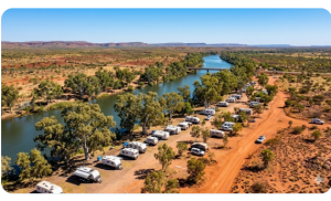
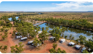
2. Overview — What Is Mary Pool Rest Area?
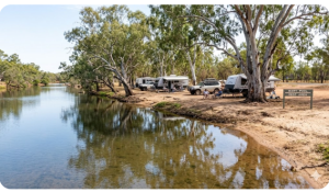
Mary Pool Rest Area is a free roadside rest stop and informal camping area located on the Great Northern Highway (also designated as National Highway 1) in the eastern Kimberley region of Western Australia. It sits beside the Mary River — a seasonal waterway that forms picturesque pools in the dry season — and is surrounded by typical Kimberley bushland: boab trees, spinifex, red earth, and the vast open sky that makes this part of Australia so unforgettable.
The rest area is managed by Main Roads Western Australia (MRWA) and is primarily intended as a fatigue stop for drivers tackling the long stretch between Halls Creek and Fitzroy Crossing — a distance of approximately 290 kilometres with no towns, no fuel, and essentially no services in between. Because of this isolation, overnight camping is permitted and actively used by thousands of travellers each dry season.
For grey nomads heading across the top of Australia — whether on the classic “big lap” or exploring the Kimberley as a destination — Mary Pool is more than just a rest stop. It’s a camp where you’ll meet fellow travellers, enjoy sundowners beside the river, and experience the raw beauty and silence of one of the most remote highways in the country.
That said, it’s basic. This is not a caravan park. There’s no power, no water, no showers, no camp kitchen, and no mobile phone reception. You need to arrive fully self-sufficient and prepared for genuine outback conditions.
3. Location, Coordinates & Address
| Field | Details |
|---|---|
| Name | Mary Pool Rest Area |
| Address | Great Northern Highway, approximately 110 km west of Halls Creek, WA |
| Postcode | 6770 |
| Latitude | -18.6247 |
| Longitude | 127.7753 |
| Coordinate Source | WikiCamps AU, cross-referenced with Google Maps satellite imagery and public mapping databases. Publicly available coordinates. |
| LGA / Shire | Shire of Halls Creek |
| Region | Kimberley, Western Australia |
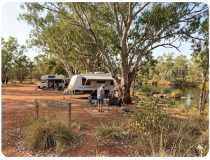
4. Facilities & Amenities
Mary Pool Rest Area is a basic government rest stop. It provides the bare essentials for a safe overnight stay but nothing more. Here’s exactly what you’ll find — and what you won’t.
| Facility | Available? | Notes |
|---|---|---|
| Toilets | ✅ Yes | Pit toilet (long drop). Not flushing. BYO toilet paper. Can be in poor condition at end of season. |
| Drinking Water | ❌ No | No potable water available. Carry all drinking water. |
| Showers | ❌ No | No showers of any kind. |
| Power / Electricity | ❌ No | No power. Solar panels and generators are your only options. |
| Picnic Tables | ✅ Yes | Concrete/timber picnic tables available. |
| Shade Shelters | ✅ Yes | Covered shelters over some picnic areas. Natural shade from boab and other trees throughout. |
| Rubbish Bins | ✅ Yes | Bins provided but may overflow during peak season. Take rubbish with you if full. |
| BBQ Facilities | ❌ No | No public BBQs. BYO cooking equipment. |
| Dump Point | ❌ No | Nearest dump points: Halls Creek or Fitzroy Crossing. |
| Fire Rings / Pits | ❌ No | No designated fire rings. Ground fires may be permitted outside fire ban periods — check current restrictions. |
| Mobile Phone Reception | ⚠️ Very Limited | Telstra may have weak/intermittent signal. No Optus or Vodafone. No public WiFi. |
| Wheelchair Access | ⚠️ Limited | Ground is uneven dirt/gravel. Toilet may not be wheelchair accessible. |
5. Getting There — Road Conditions & Directions
From Halls Creek (Heading West)
Depart Halls Creek on the Great Northern Highway heading west towards Fitzroy Crossing. Mary Pool Rest Area is approximately 110 km west of Halls Creek. The highway is fully sealed and in generally good condition during the dry season (April/May to October/November). The turn-off into the rest area is on the south side of the highway (your left when heading west). It is signed, though signage can be modest — look for the standard blue rest area road sign. The entry track into the camping area is a short unsealed section, typically hard-packed gravel/dirt, suitable for all vehicles.
From Fitzroy Crossing (Heading East)
From Fitzroy Crossing, head east on the Great Northern Highway. Mary Pool Rest Area is approximately 180 km east of Fitzroy Crossing. The rest area turn-off will be on your right side when heading east. Again, the highway is sealed the entire way. Allow approximately 2 hours driving time depending on road trains and conditions.
Road Surface
The Great Northern Highway between Halls Creek and Fitzroy Crossing is a fully sealed, single-carriageway highway. It is well maintained during the dry season but can develop rough patches, corrugations on the edges, and may have sections of roadworks. The highway carries road trains (triple-trailer trucks), so be prepared to pull over and give them room when passing.
The entry track into Mary Pool Rest Area itself is unsealed — typically compacted gravel and dirt for a few hundred metres. During the dry season this is suitable for all vehicles including towed caravans and large motorhomes. After rain, it can become soft or boggy in patches.
6. Does the Road Flood? Wet Season Warnings
Yes — emphatically yes. The Great Northern Highway between Halls Creek and Fitzroy Crossing crosses multiple river systems and flood plains, including the Mary River at Mary Pool itself. During the wet season (roughly November through March/April), this stretch of highway is subject to:
- Road closures — the highway can be closed entirely for days or even weeks at a time due to flooding
- Floodway crossings — several sections of the highway cross floodways that become impassable during and after heavy rain
- Soft or washed-out shoulders — even when the road is “open,” conditions can be hazardous
- Mary River flooding — the river can rise rapidly, inundating the rest area and the highway crossing
The dry season (May through October) is the only reliable time to travel this route. Even in the early dry (May) or late dry (October/November), occasional late or early storms can cause localised flooding. Always have a contingency plan and enough supplies to wait out a road closure.
Flooding Quick Reference
| Season | Flood Risk | Road Status |
|---|---|---|
| May – September | Low | Generally open and dry. Peak travel season. |
| October – November | Moderate | Build-up season. Storms possible. Check conditions daily. |
| December – April | Very High | Road frequently closed. Expect multi-day closures. Not recommended for travel. |
7. Fuel Station Distances — North, South, East & West
Fuel planning is critical on this stretch of highway. The distance between Halls Creek and Fitzroy Crossing — approximately 290 km — has no fuel available in between. Mary Pool is roughly in the first third of that gap if heading west from Halls Creek. Here’s your fuel planning guide from Mary Pool in every direction.
| Direction | Nearest Fuel | Distance (approx.) | Notes |
|---|---|---|---|
| East | Halls Creek | ~110 km | Multiple fuel stations in town. Diesel, unleaded, LPG available. Last fuel before the long gap heading west. |
| West | Fitzroy Crossing | ~180 km | Fuel available in town. Check opening hours — some stations have limited hours. |
| North | N/A — no road north | — | No public road heading north from Mary Pool. The highway runs east–west here. |
| South | N/A — no road south | — | No public road heading south from Mary Pool. Nearest southbound route via Halls Creek on the Tanami Track (unsealed, 4WD only) to Alice Springs — approx. 1,000+ km to next fuel at Rabbit Flat or Yuendumu (check availability). |
Extended Fuel Planning — The Bigger Picture
To give you full context for your Kimberley journey, here are the broader fuel gaps along the Great Northern Highway:
| Route Segment | Distance | Fuel Between? |
|---|---|---|
| Kununurra → Halls Creek | ~360 km | Yes — Warmun (Turkey Creek), ~50 km south of Kununurra. Check hours/availability. |
| Halls Creek → Fitzroy Crossing | ~290 km | ❌ NO fuel between these two towns. This is where Mary Pool sits. |
| Fitzroy Crossing → Broome | ~390 km | Yes — Willare Bridge Roadhouse (~260 km west of Fitzroy Crossing). Check availability. |
8. Vehicle Suitability — Caravans, Motorhomes & 4WDs
Because the Great Northern Highway is sealed and Mary Pool’s entry track is a short, generally well-maintained gravel section, most vehicle types can access Mary Pool Rest Area during the dry season. Here’s the breakdown:
| Vehicle Type | Suitable? | Notes |
|---|---|---|
| 2WD Car | ✅ Yes | Sealed highway access. Rest area entry is short unsealed section — generally fine for 2WD in dry conditions. |
| Caravan (any size) | ✅ Yes | Large caravans and rigs regularly use Mary Pool. Ample space to park and turn. Flat ground. |
| Motorhome / Bus | ✅ Yes | Large motorhomes and converted buses can access the site. Good clearance. |
| Campervan | ✅ Yes | No issues. |
| 4WD / Off-road Camper | ✅ Yes | Ideal vehicle for the Kimberley region. |
| Roof-top Tent / Swag | ✅ Yes | Ground is flat and suitable. Be aware of ants, snakes, and other wildlife if sleeping on the ground. |
| Motorcycle / Bicycle | ✅ Yes (with caution) | Motorcyclists and cyclists use this route. Carry extreme amounts of water. Heat is a serious risk. |
9. Camping Details — Cost, Stay Limits & Rules
| Detail | Information |
|---|---|
| Cost | Free. No fees. No bookings. |
| Stay Limit | No formal time limit posted but intended for short-stay overnight use (1–2 nights maximum). This is a rest area, not a long-term campground. |
| Bookings | None required. First-come, first-served. |
| Sites | Informal. No designated sites. Park where suitable on flat ground. |
| Ground Surface | Compacted red dirt/gravel. Generally flat and firm in the dry season. |
| Dogs | Allowed. Keep on lead. Do NOT let dogs near the river — crocodile risk. |
| Generators | Permitted. Be courteous — most travellers appreciate quiet after 9 pm. |
| Fires | Check current fire ban status. No designated fire rings. If fires are permitted, use an above-ground fire pit and ensure it is fully extinguished before leaving. |
| Capacity | Can accommodate 15–25+ rigs depending on parking arrangement. Can get busy during peak season (June–August). |
During peak grey nomad season (June through August), Mary Pool can become quite busy, particularly on weekends or when road conditions elsewhere cause travellers to bunch up. Arrive by mid-afternoon to secure a good spot with shade. The camping area spreads out along the river, giving a reasonable sense of space even when busy.
10. Safety — Crocodiles, Heat, Isolation & Emergencies
Mary Pool Rest Area is located in one of Australia’s most remote and challenging environments. Safety must be taken seriously.
🐊 Crocodiles
🌡️ Heat & Dehydration
The Kimberley is extremely hot, even during the dry season. Daytime temperatures of 30–38°C are common from May to September, and temperatures can exceed 40°C in October and November (the “build-up” season). Dehydration, heat exhaustion, and heatstroke are serious risks — especially for older travellers and those with medical conditions.
- Drink a minimum of 4–6 litres of water per person per day, more if active or in extreme heat
- Carry at least 10 litres per person per day as a reserve for emergencies and vehicle breakdowns
- Stay in shade during the hottest part of the day (11 am – 3 pm)
- Wear a hat, sunscreen, and light loose-fitting clothing
🏥 Medical Emergencies
The nearest hospitals are in Halls Creek (~110 km east) and Fitzroy Crossing (~180 km west). Both are small regional hospitals with limited emergency departments. For serious medical emergencies, the Royal Flying Doctor Service (RFDS) can be contacted on 1800 625 800 (if you can get phone reception) or via emergency satellite communication devices. Carry a comprehensive first aid kit and any prescription medications with ample supply.
🐍 Snakes & Wildlife
The Kimberley is home to numerous venomous snake species, including king brown snakes (mulga snakes) and western brown snakes. Always wear enclosed shoes when walking, check around and under your vehicle before moving, and use a torch at night. Don’t put your hands into logs, crevices, or anywhere you can’t see.
🚗 Vehicle Breakdowns
If your vehicle breaks down between Halls Creek and Fitzroy Crossing, you may wait hours or even longer for another vehicle to pass. Stay with your vehicle. It provides shade, shelter, and makes you easier to spot. Carry a satellite phone or satellite communicator (such as a Garmin inReach or SPOT device) for emergencies. Roadside assistance services (RACWA, RACQ, etc.) have very limited coverage in this area and response times can be 24+ hours.
11. Phone Reception & WiFi
| Carrier | Reception at Mary Pool |
|---|---|
| Telstra | Very weak / intermittent. May get occasional signal with an external antenna or booster. Not reliable for calls or data. |
| Optus | No coverage. |
| Vodafone / TPG | No coverage. |
| Public WiFi | None available at Mary Pool. Nearest public WiFi in Halls Creek (~110 km) or Fitzroy Crossing (~180 km) — typically at libraries, visitor centres, or roadhouses. |
A Cel-Fi GO mobile booster (Telstra-compatible) can sometimes pull in enough signal for basic text messages if you’re on the edge of coverage, but don’t rely on it. For reliable communication, a satellite phone (Iridium or Thuraya) or satellite communicator (Garmin inReach, Zoleo, SPOT) is the only option.
If you need to download maps, check emails, make appointments, or contact family, do so in Halls Creek or Fitzroy Crossing before departing. Download entertainment (podcasts, audiobooks, streaming content) in advance — there is no data connectivity at Mary Pool.
12. Water, Food & Supply Planning
There are absolutely no shops, no fuel, and no water taps between Halls Creek and Fitzroy Crossing. You must be completely self-sufficient. Here’s how to plan:
Water
- Minimum: 10 litres per person per day (drinking + cooking + washing)
- Recommended: 15 litres per person per day if staying more than one night, to account for the extreme heat
- Emergency reserve: Always carry an additional 20–40 litres in case of vehicle breakdown or road closure
- Fill up all tanks, jerry cans, and bottles in Halls Creek or Fitzroy Crossing
- The river water at Mary Pool is NOT safe for drinking without treatment (boiling + filtration minimum). It may contain bacteria, parasites, and sediment.
Food
- Carry all food for the journey between towns
- Choose shelf-stable items that tolerate heat: tinned goods, crackers, dried fruit, nuts, long-life milk, pasta, rice
- Keep perishables in a good-quality 12V fridge/freezer — an esky with ice won’t last in Kimberley heat
- Stock up at supermarkets in Halls Creek or Fitzroy Crossing — selection is limited and prices are high, so buy in bulk in larger towns like Kununurra, Broome, or Darwin if possible
Other Supplies
- Toilet paper (BYO — rest area supplies are unreliable)
- Insect repellent (mosquitoes and midges can be fierce, especially near the river)
- Sunscreen — SPF 50+
- Spare vehicle parts: fan belts, radiator hoses, fuses, tyre repair kit, tyre pump
- Spare tyres — carry at least two full-size spares for Kimberley travel
- Basic tools
- First aid kit including snake bandage, burn gel, and any prescription medications
13. Best Time to Visit
| Month | Conditions | Recommendation |
|---|---|---|
| January – March | Wet season. Heavy rain, flooding, extreme humidity, 35–45°C. | ❌ Not recommended. Road likely closed. |
| April | Transition. Rain easing, roads reopening, still hot and humid. | ⚠️ Possible but risky. Check road conditions daily. |
| May – June | Early dry season. Warm days (28–34°C), cool nights (15–20°C). Roads open. | ✅ Excellent. Pools full from wet season. Less crowded than peak. |
| July – August | Peak dry season. Warm days (30–33°C), cool nights (12–18°C). Driest months. | ✅ Peak season. Best weather but busiest with grey nomads. |
| September | Late dry. Warming up (33–37°C). Pools drying out. | ✅ Good but getting hot. Fewer travellers. |
| October – November | Build-up. Very hot (35–42°C), humid, storm risk increasing. | ⚠️ Caution. Heat is extreme. Storms can close roads quickly. |
| December | Wet season begins. Monsoonal storms, flooding likely. | ❌ Not recommended. |
The sweet spot for grey nomads is May through August. You’ll get the best weather, the roads will be open and in good condition, the pools will have water, and you’ll share the camp with fellow travellers heading across the top.
14. Grey Nomad Tips for Mary Pool
Having gathered advice from travellers who have camped at Mary Pool over recent dry seasons, here are the practical tips that make the biggest difference:
15. Nearby Free Camps & Rest Areas
If Mary Pool is full or doesn’t suit your needs, here are alternative free camps and rest areas along the Great Northern Highway between Halls Creek and Fitzroy Crossing:
| Name | Distance from Mary Pool | Direction | Notes |
|---|---|---|---|
| Ngumban Cliff Rest Area | ~55 km | East (towards Halls Creek) | Scenic rest area with cliff views. Toilet. Free camping. Popular alternative. |
| Margaret River Rest Area | ~70 km | West (towards Fitzroy Crossing) | Beside Margaret River. Toilet. Free. Shady. Note: not the Margaret River in SW WA! |
| Halls Creek Caravan Park / Free Camp Areas | ~110 km | East | Halls Creek has a caravan park and some free/low-cost camping options. Full town services — fuel, water, shops, hospital. |
| Fitzroy Crossing Caravan Parks | ~180 km | West | Fitzroy Crossing has caravan parks with powered sites, showers, dump points. Full town services. |
16. Nearby Attractions & Things to Do
Mary Pool itself is located in a relatively featureless stretch of highway, but the surrounding Kimberley region is rich in natural wonders. Here’s what’s nearby (relative to Kimberley distances):
From Halls Creek (110 km east)
- Wolfe Creek Crater National Park — One of the world’s best-preserved meteorite craters. Approx. 130 km south of Halls Creek via the Tanami Track (unsealed, 4WD recommended). Free camping at the crater.
- China Wall — A natural quartz formation resembling the Great Wall of China, just 6 km from Halls Creek town. Free to visit.
- Old Halls Creek (historical town site) — Ruins of the original 1885 gold rush settlement, 15 km from the current town.
- Palm Springs — A beautiful swimming hole and walking trail near Halls Creek. Check crocodile status before swimming.
From Fitzroy Crossing (180 km west)
- Geikie Gorge National Park (Darngku) — Stunning gorge on the Fitzroy River with boat tours that showcase freshwater crocodiles, wildlife, and ancient reef formations. Located just 18 km from Fitzroy Crossing. Highly recommended.
- Tunnel Creek National Park — Walk through a 750-metre natural tunnel through a range of the Napier Range. Approx. 110 km from Fitzroy Crossing. 4WD access road.
- Windjana Gorge National Park — Spectacular gorge with ancient Devonian reef walls and dozens of freshwater crocodiles. Camping available (DBCA fees apply). Approx. 145 km from Fitzroy Crossing via the Fairfield-Leopold Downs Road (partially unsealed).
The Broader Kimberley
- Purnululu National Park (Bungle Bungles) — World Heritage–listed beehive formations. Accessed via a turn-off approximately 250 km east of Mary Pool (near the Spring Creek Track turn-off south of Halls Creek on the Great Northern Hwy heading north towards Kununurra). 4WD only access road.
- Gibb River Road — Iconic 4WD adventure track from Derby to Kununurra, accessed from either Fitzroy Crossing area or further north. Not suitable for caravans except for some off-road camper trailers.
17. Printable Kimberley Road Trip Checklist
📥 Download: Kimberley Remote Travel Checklist
Use this checklist before departing for Mary Pool or any remote Kimberley rest area. Print it or save it to your phone (offline) for reference on the road.
🚗 Vehicle & Fuel
- ☐ Full fuel tank
- ☐ 20L+ spare fuel in approved jerry can(s)
- ☐ Two full-size spare tyres
- ☐ Tyre repair kit and pump/compressor
- ☐ Basic tools (spanners, pliers, screwdrivers, duct tape, cable ties)
- ☐ Spare fan belt, radiator hose, fuses
- ☐ Recovery gear (rated snatch strap, shackles, shovel) if going off-highway
- ☐ Vehicle serviced and fluids checked
💧 Water & Food
- ☐ Minimum 10L water per person per day (ideally 15L)
- ☐ 20–40L emergency water reserve
- ☐ Non-perishable food for duration + 2 extra days
- ☐ 12V fridge stocked and running
- ☐ Cooking equipment and fuel (gas bottle/canister)
🏥 Safety & Medical
- ☐ Comprehensive first aid kit
- ☐ Snake bandage(s)
- ☐ Prescription medications (extra supply)
- ☐ Sunscreen SPF 50+
- ☐ Insect repellent (DEET-based)
- ☐ Hat and sun-protective clothing
- ☐ Satellite communicator or satellite phone
🗺️ Navigation & Communication
- ☐ Offline maps downloaded (Google Maps, Hema, WikiCamps)
- ☐ GPS with Kimberley waypoints loaded
- ☐ Road condition report checked (Main Roads WA: 138 138)
- ☐ Emergency contacts written down (not just in phone)
- ☐ RFDS contact: 1800 625 800
🏕️ Camping
- ☐ Toilet paper (lots)
- ☐ Portable toilet (if no onboard toilet)
- ☐ Torch/headlamp with spare batteries
- ☐ Camp chairs and table
- ☐ Fly net / head net for insects
- ☐ Firewood (if fires permitted — don’t collect native timber)
- ☐ Rubbish bags (take all waste with you)
18. Frequently Asked Questions
Is Mary Pool Rest Area free to camp at?
Yes. Mary Pool Rest Area is completely free. There are no fees, no bookings required, and no registration. It is a Main Roads WA rest area intended for driver fatigue breaks and overnight camping. First-come, first-served.
Does Mary Pool Rest Area have toilets?
Yes — there is a pit toilet (long-drop / drop toilet). It is not a flushing toilet. There is no running water for handwashing. The toilet condition varies throughout the season and can be quite unpleasant by late in the dry season when many travellers have passed through. BYO toilet paper, hand sanitiser, and consider bringing your own portable toilet.
Can I swim at Mary Pool?
Swimming is strongly discouraged. Mary Pool is a natural waterhole on the Mary River in the Kimberley. Freshwater crocodiles are known to inhabit this waterway, and saltwater crocodiles may also be present — particularly during or after the wet season. There are no crocodile management programs at this location. If you choose to enter the water, you do so entirely at your own risk. Keep pets and children well away from the water’s edge at all times.
Is the road to Mary Pool sealed or unsealed?
The Great Northern Highway is fully sealed between Halls Creek and Fitzroy Crossing. The short access track into the Mary Pool Rest Area itself is unsealed — compacted gravel/dirt — but is suitable for all vehicles including caravans and motorhomes during the dry season.
How far is the nearest fuel from Mary Pool?
The nearest fuel is in Halls Creek, approximately 110 km to the east, or Fitzroy Crossing, approximately 180 km to the west. There is NO fuel available between these two towns. Always fuel up before departing either town and carry spare fuel.
Is there phone reception at Mary Pool?
Phone reception is extremely limited. Telstra may provide a very weak or intermittent signal — don’t rely on it. Optus and Vodafone have no coverage. There is no public WiFi. A satellite communicator is recommended for emergency communication.
Can I take a caravan to Mary Pool?
Yes. The sealed highway and short unsealed rest area entry are suitable for caravans of all sizes during the dry season. The camping area has ample flat space for large rigs.
Are dogs allowed at Mary Pool Rest Area?
Yes, dogs are allowed. Keep them on a lead at all times and never let them near the river. Crocodiles have taken dogs in the Kimberley. Be vigilant.
Is there a dump point at Mary Pool?
No. The nearest dump points are in Halls Creek (approximately 110 km east) and Fitzroy Crossing (approximately 180 km west).
How long can I stay at Mary Pool Rest Area?
There is no formally posted stay limit, but Mary Pool is a rest area — not a long-term campground. A stay of 1–2 nights is the accepted norm. Extended stays may attract attention from other travellers or authorities. If you need a longer stay, consider a caravan park in Halls Creek or Fitzroy Crossing.
Is Mary Pool safe for solo travellers?
Mary Pool is generally safe, but it is extremely remote. Solo travellers should take extra precautions: tell someone your itinerary, carry a satellite communicator, and ensure your vehicle is in excellent condition. During peak season, the camp is usually busy with other grey nomads which adds a sense of community and security. Outside peak season, you may be entirely alone.
19. Final Verdict — Is Mary Pool Worth the Stop?
Absolutely — but only if you’re prepared.
Mary Pool Rest Area is one of those quintessential outback Australian free camps that reward the self-sufficient traveller. The setting is beautiful — boab trees, red earth, the quiet pools of the Mary River, and skies full of stars. It’s a genuine taste of the Kimberley, and it’s completely free.
But it demands respect. This is not a caravan park. There’s no water, no power, no phone reception, and crocodiles live in the river. The nearest help is over 100 kilometres away in either direction. You need to arrive with enough water, fuel, food, and supplies to be completely self-sufficient — and you need a plan for emergencies.
For grey nomads doing the big lap or exploring the Kimberley, Mary Pool is a natural overnight stop on one of Australia’s great long-distance drives. The distance between Halls Creek and Fitzroy Crossing is too far for many travellers to do comfortably in a single stint, especially if towing a caravan. Breaking it up at Mary Pool makes the journey safer, more enjoyable, and gives you a memory of the Kimberley that no caravan park could match.
Fill your tanks. Check the road conditions. Download your offline maps. Pack your water. And enjoy one of the best free camps in the Australian outback.
🌟 Found this guide helpful?
Share it with a fellow grey nomad or save it for your Kimberley trip. Safe travels from the Retire to Van Life team!
🛒 Recommended Gear for Kimberley Travel
Here are some of the products grey nomads find essential for remote Kimberley travel. (These may include affiliate links — we only recommend products we believe in.)
- Garmin inReach Mini 2 — Satellite communicator with SOS. Essential for remote travel without phone reception.
- Hema HX-2 GPS Navigator — Purpose-built for Australian outback navigation with offline topographic maps.
- WikiCamps AU App — Download before you leave for offline free camp and rest area data across Australia.
- Companion 20L Metal Jerry Can — Australian Standards–compliant fuel container for spare fuel.
- Kings 200W Solar Blanket — Portable solar panel to keep your batteries charged at camps without power.
- Dometic CFX3 55IM Fridge/Freezer — Reliable 12V compressor fridge for keeping food cold in extreme heat.
🔗 Useful Links & Resources
- Main Roads WA — Live Travel Map & Road Conditions
- Emergency WA — Alerts, Warnings & Road Closures
- WA Department of Biodiversity, Conservation & Attractions (DBCA) — National park info, permits & campground bookings
- Royal Flying Doctor Service — Emergency: 1800 625 800
- Main Roads WA Road Conditions Hotline: 138 138
© 2026 Retire to Van Life · retiretovanlife.com
Mary Pool Rest Area Free Camping Senior Grey Nomad Guide 2026
Free campsites along the Great Northern Highway fill fast in peak season (May–August). If you need a powered site, a room or a cabin at either end of this corridor, search below.
Accommodation and flight search powered by Expedia. Booking through this search supports this website at no extra cost to you. As an affiliate, I earn from qualifying purchases at no extra cost to you.

As an affiliate, I earn from qualifying purchases at no extra cost to you.
As an affiliate, I earn from qualifying purchases at no extra cost to you.