Lyndon River Rest Area — Free Camping Senior Grey Nomad Guide 2026
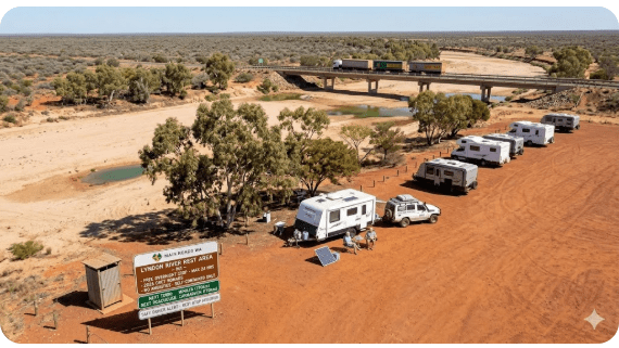
Lyndon River Rest Area is one of the most relied-upon free overnight stops on the North West Coastal Highway for senior grey nomads travelling between Carnarvon and Exmouth in Western Australia in 2026. Located approximately 170 km north of Carnarvon and 190 km south of the Exmouth turnoff (Minilya–Exmouth Road junction), this Main Roads WA rest area sits beside the Lyndon River crossing in some of the most isolated and visually stark outback country on the entire west coast drive. For grey nomads over 60, this is not a scenic campsite — it is a survival stop. A place where experienced travellers break a brutally long highway stretch into manageable legs, sleep safely, and continue fresh the next morning.
This guide gives you the honest detail — GPS coordinates, facilities, dump points, water, mobile coverage, medical access, and genuine senior verdicts — so you can plan your Lyndon River stop with confidence. Whether you are heading north to Exmouth and Ningaloo Reef on one of the classic grey nomad routes around Australia or making the long southbound run from the Pilbara, the Lyndon River Rest Area requires proper preparation.
- 1. Why Grey Nomads Stop at Lyndon River Rest Area
- 2. Free Camping at Lyndon River — Remote, Basic, and Brutally Honest
- 3. Your Two Main Options Side by Side
- 4. Lyndon River Rest Area: Quick Facts and Facilities
- 5. Extreme Heat, Isolation, and Distance — What This Means for Seniors
- 6. What Lyndon River Rest Area Doesn’t Tell You Online
- 7. Free and Low-Cost Camping Near Lyndon River
- 7b. Dump Points — Before, On-Site, and After
- 7c. Free Water Top-Up Points
- 8. Coral Bay — The Paid Alternative for Grey Nomads
- 9. Full Facilities Comparison
- 10. Rates: All Options
- 11. Lyndon River to Exmouth or Coral Bay Day Plan for Seniors
- 12. Senior Checklist: Lyndon River Rest Area
- 13. What to Do Near Lyndon River: Senior Activity Plan
- 14. GPS Coordinates and Postcodes — Save Every Stop
- 15. FAQs — Lyndon River Rest Area for Grey Nomads
- 16. Quick-Reference Card and Booking Links
1. Lyndon River Rest Area and the North West Coastal Highway: Why Grey Nomads Stop Here
The Lyndon River Rest Area in 2026 exists for one simple, critical reason: the distance between Carnarvon and the Exmouth/Coral Bay turnoffs is too far for most seniors to drive safely in a single session, particularly towing a large caravan in extreme heat. The full Carnarvon-to-Exmouth run is approximately 360 km of remote, featureless highway with almost no services. For a grey nomad over 60 who started the day in Carnarvon, the Lyndon River Rest Area represents the halfway point — the place where fatigue, heat, and monotony say “stop here or risk falling asleep at the wheel.”
For seniors exploring living in a camper during retirement, this stretch of highway is where the Gascoyne region transitions into genuine outback. The landscape is red dirt, spinifex, and horizon. Phone coverage disappears. The temperature gauge climbs. And the Lyndon River Rest Area — flat, gravel, basic — becomes the most welcome sight on the highway.
2. Free Camping at Lyndon River — Remote, Basic, and Brutally Honest
The Lyndon River Rest Area is not glamorous. It is not scenic in the way that coastal camps are scenic. It is a functional highway pullover beside a dry riverbed in the middle of arid scrubland. But it serves its purpose, and for seniors, understanding exactly what it offers — and what it does not — is the difference between a safe overnight stop and a miserable experience:
- No toilets. There is no toilet of any kind. No pit toilet, no portaloo. You must be completely self-contained with your own onboard toilet.
- No water. There is no potable water. The Lyndon River is typically dry and even when flowing, the water is not drinkable. Arrive with absolutely full tanks.
- No dump point. The nearest dump points are in Carnarvon (170 km south) or Exmouth (approximately 360 km north via Minilya–Exmouth Road).
- No power. No 240V outlets. CPAP users need fully charged lithium batteries.
- Minimal shade. A few scattered trees along the riverbed may provide some shade, but do not count on it. The rest area is mostly exposed.
- Extreme remoteness. The nearest medical facility is Carnarvon Hospital — approximately 170 km south. The nearest alternative is Exmouth Hospital — approximately 360 km north. You are genuinely in the middle of nowhere.
- No phone signal. Telstra coverage is nil to extremely weak. Optus is nil. A PLB or satellite communicator is essential, not optional.
3. Your Two Main Options Side by Side — Lyndon River vs Coral Bay
| Feature | Lyndon River Rest Area (Free) | Peoples Park Coral Bay (Paid) |
|---|---|---|
| Cost | Free — no permit | From ~$50–$70/night powered |
| Booking Required | No — first come, first served | Essential in peak season |
| 240V Power | ❌ None | ✅ Powered sites |
| Toilets | ❌ None | ✅ Flush toilets, hot showers |
| Dump Point | ❌ None | ✅ On-site |
| Potable Water | ❌ None | ✅ Yes |
| Shade | ⚠️ Minimal — some riverbed trees | ✅ Some shaded sites |
| Dogs | ✅ Yes — on lead. Watch for snakes. | ✅ Check park rules |
| Phone Coverage | ❌ Nil — PLB essential | ✅ Telstra reliable in Coral Bay |
| Medical Proximity | 170 km to Carnarvon Hospital | ~150 km to Exmouth Hospital |
| Senior Recommendation | ⚠️ One night max — experienced, self-contained travellers only | ✅ Multi-night base with reef access |
4. Lyndon River Rest Area: Quick Facts, Facilities, and GPS for 2026
| Detail | Information |
|---|---|
| Full Name | Lyndon River Rest Area |
| Address | North West Coastal Highway, Lyndon, WA 6701 |
| GPS | -23.7470, 114.1330 |
| Cost | Free — no permit, no registration |
| Managed By | Main Roads Western Australia |
| Stay Limit | 24 hours maximum |
| Toilets | ❌ None — must be fully self-contained |
| Water | ❌ No potable water |
| Dump Point | ❌ None — nearest in Carnarvon or Exmouth |
| Power | ❌ No 240V |
| Surface | Gravel and compacted earth — generally flat beside river crossing |
| Shade | ⚠️ Minimal — some trees along the dry riverbed |
| Dogs | ✅ Yes — on lead. Snakes active in warm months. |
| Big Rig Access | ✅ Suitable for large caravans and motorhomes — easy pull-off from highway |
| Phone Coverage | ❌ Telstra nil. Optus nil. PLB or satellite communicator essential. |
| Nearest Hospital | Carnarvon Hospital, Cleaver Street, Carnarvon, WA 6701 — GPS: -24.8840, 113.6590 — 08 9941 0555 — approx. 170 km south |
| Alternative Hospital | Exmouth Hospital, Lyons Street, Exmouth, WA 6707 — GPS: -21.9400, 114.1250 — 08 9949 2444 — approx. 360 km north |
| Nearest Fuel | Minilya Roadhouse (~100 km north) or Carnarvon (~170 km south) |
5. Extreme Heat, Isolation, and Distance — What Lyndon River Means for Seniors
Lyndon River Rest Area is one of the most remote free camps covered in any guide on this website. The three challenges it presents to seniors are not individually unusual for outback WA — but combined, they demand serious respect.
Heat
From October to March, daytime temperatures at Lyndon River regularly exceed 42°C and can reach 48°C during extreme heatwave events. The area is inland, arid, and has no coastal breeze. At night, temperatures may not drop below 30°C. Without powered air conditioning, the interior of your van will be dangerously hot. For seniors on blood pressure medication, diuretics, antihistamines, or any drug that affects thermoregulation, camping here in summer without robust off-grid cooling is medically reckless. The best months for seniors are May to September when daytime temperatures are 22–30°C.
Medical Distance
You are 170 km from Carnarvon Hospital and approximately 360 km from Exmouth Hospital. There is no phone signal to call 000. A PLB activation is the only reliable way to summon help — and RFDS response time from Carnarvon or Meekatharra to the Lyndon River can exceed 2 hours. For a cardiac event, stroke, or severe allergic reaction, this response time is critical. Seniors with serious medical conditions must ask themselves honestly: is one night’s free camping worth the risk of being this far from help with no way to call?
Road Train Traffic
The North West Coastal Highway at Lyndon River carries heavy road train traffic between Carnarvon and the Pilbara. Trucks pass through the night. The rest area is adjacent to the highway, and noise is unavoidable. Earplugs are recommended.
6. What Lyndon River Rest Area Doesn’t Tell You Online
Free camping apps show a pin on the highway and “free.” Here are the details that specifically matter to senior travellers:
- The riverbed may have shade trees. Depending on recent floods and regrowth, scattered trees along the Lyndon River channel may provide some shade. Park under these if available — but do not rely on them. In drought years, the trees may be sparse or dead.
- Other travellers provide security. During peak travel season (May–September), this rest area is rarely empty. 5–20 other vans typically stop here overnight. This natural community provides safety, conversation, and mutual assistance. Off-peak (summer), you may be entirely alone.
- Snakes are present. The scrubland and dry riverbed around Lyndon River are active snake habitat, particularly October to March. Mulga snakes (king browns) and western brown snakes are present in this region. Wear closed shoes at all times outside the van. Do not walk in long grass. Check under the van before packing up. Keep dogs on a short lead.
- Stargazing is world-class. With zero light pollution, the night sky at Lyndon River is extraordinary. The Milky Way arches overhead with a clarity that city dwellers cannot imagine. If you have binoculars, bring them. This is genuinely one of the rewards of outback free camping.
- No bins — leave no trace. There are no rubbish bins. Take all waste with you.
- Fuel strategy is critical. The nearest fuel is Minilya Roadhouse (~100 km north) or Carnarvon (~170 km south). If heading north, Minilya is closer but fuel prices are significantly higher than Carnarvon. Fill your tank completely in Carnarvon before heading north.
COPY PROMPT ➔ ASK AI ➔ SAVE TO FORM ➔ ADD SPOT PIN ➔ GET DIRECTIONS
📍 Interactive map — find free camps, rest areas and overnight stops. Enable location for best results.
7. Van Life Savings Spots: Free and Low-Cost Camping Near Lyndon River in 2026
Use the Van Life Savings Spots app to find and save free camps along this route. Try AI queries like: “Free camping between Carnarvon and Exmouth for self-contained caravans” or “Rest areas on North West Coastal Highway WA” or “Dog-friendly free camps near Coral Bay.”
| Free Camp | Cost | Address / Postcode | GPS | Distance | Senior Verdict |
|---|---|---|---|---|---|
| Lyndon River Rest Area | Free | North West Coastal Hwy, Lyndon, WA 6701 | -23.7470, 114.1330 | On-site | ⚠️ Very remote. Zero facilities. Experienced self-contained only. |
| Minilya River Rest Area | Free | North West Coastal Hwy, near Minilya, WA 6701 | -23.5330, 114.0170 | ~30 km north | ⚠️ Similar — remote, basic. Slightly closer to Minilya Roadhouse for fuel. |
| Minilya Roadhouse | Paid camping / free rest area adjacent | North West Coastal Hwy, Minilya, WA 6701 | -23.3830, 114.0110 | ~100 km north | ✅ Fuel, basic supplies, some facilities. Better option if continuing north. |
| Coral Bay (various parks) | From ~$50/night | Coral Bay, WA 6701 | -23.1530, 113.7650 | ~150 km north-west | ✅ Reef snorkelling. Powered sites. Medical access closer. Senior-friendly. |
7b. Dump Points — Before, On-Site, and After Lyndon River Rest Area
| 🗑️ Dump Point | Address / Postcode | GPS | Distance from Lyndon River | Notes |
|---|---|---|---|---|
| Before — Carnarvon Dump Point | Babbage Island Road, Carnarvon, WA 6701 | -24.8970, 113.6620 | ~170 km south | Free. 24-hour access. |
| On-site — Lyndon River Rest Area | North West Coastal Hwy, Lyndon, WA 6701 | -23.7470, 114.1330 | — | ❌ No dump point on-site |
| After — Coral Bay Dump Point | Coral Bay Road, Coral Bay, WA 6701 | -23.1530, 113.7650 | ~150 km north-west | Free. Near caravan park entrance. |
| After — Exmouth Dump Point | Murat Road, Exmouth, WA 6707 | -21.9330, 114.1280 | ~360 km north | Free. 24-hour access. Well signed in town. |
7c. Free Water Top-Up Points Near Lyndon River Rest Area
| 💧 Water Point | Address / Postcode | GPS | Distance | Notes |
|---|---|---|---|---|
| On-site — Lyndon River | North West Coastal Hwy, Lyndon, WA 6701 | -23.7470, 114.1330 | — | ❌ No potable water |
| Before — Carnarvon | Robinson Street, Carnarvon, WA 6701 | -24.8840, 113.6590 | ~170 km south | Multiple sources — caravan parks, fuel stations, visitor centre. Fill completely. |
| After — Minilya Roadhouse | North West Coastal Hwy, Minilya, WA 6701 | -23.3830, 114.0110 | ~100 km north | Water available with fuel purchase. Premium prices. |
| After — Coral Bay | Coral Bay Road, Coral Bay, WA 6701 | -23.1530, 113.7650 | ~150 km north-west | Water at caravan parks for guests. |
8. Peoples Park Coral Bay — The Paid Alternative for Grey Nomads
If you can secure a booking, Peoples Park Coral Bay is the most senior-friendly paid option between Carnarvon and Exmouth. Located steps from the Coral Bay beach and the Ningaloo Reef, this park offers powered sites, hot showers, and direct access to some of the best shore snorkelling in Australia.
Address: Robinson Street, Coral Bay, WA 6701 GPS: -23.1530, 113.7650 Phone: 08 9942 5933 Website: peoplesparkcoralbay.com.au
9. Full Facilities Comparison: Lyndon River vs Minilya Roadhouse vs Coral Bay
| Facility | Lyndon River Rest Area | Minilya Roadhouse | Peoples Park Coral Bay |
|---|---|---|---|
| 240V Power | ❌ | ⚠️ Limited | ✅ |
| Toilets / Showers | ❌ | ✅ Basic | ✅ Full amenities |
| Fuel | ❌ | ✅ Premium prices | ✅ |
| Dump Point | ❌ | ⚠️ Check | ✅ |
| Phone Signal | ❌ Nil | ⚠️ Weak | ✅ Reliable |
| Medical | 170 km to hospital | ~100 km to hospital | ~150 km to Exmouth Hospital |
| Stargazing | ✅ Exceptional | ✅ Good | ✅ Good |
| Senior Overall | ⭐⭐ — Drive-break only | ⭐⭐⭐ — Better with fuel and basic facilities | ⭐⭐⭐⭐ — Best senior choice |
10. Rates: All Options Near Lyndon River
| Option | Rate (2026 Guide) | Book How |
|---|---|---|
| Lyndon River Rest Area | Free | No booking — first come, first served |
| Minilya Roadhouse | From ~$20–$35/night | Check on arrival |
| Peoples Park Coral Bay ← Senior Recommended | From ~$50–$70/night powered | 08 9942 5933 or website |
11. Lyndon River to Exmouth or Coral Bay Day Plan for Seniors
- 6:00 AM — Pack up camp at Lyndon River Rest Area. GPS: -23.7470, 114.1330. Leave early to avoid the heat.
- 7:30 AM — Arrive Minilya Roadhouse (~100 km north). GPS: -23.3830, 114.0110. Fuel up. Breakfast if available. Check water levels. This is the junction where the highway continues north to Exmouth or you turn west to Coral Bay.
- Option A — Coral Bay: Turn west at Minilya onto Coral Bay Road. Approximately 150 km to Coral Bay. Sealed road. GPS: -23.1530, 113.7650. Arrive approximately 10:00 AM. Use dump point. Fill water. Check into Peoples Park. Snorkel the reef in the afternoon — the shore entry at Bills Bay is flat, shallow, and suitable for seniors.
- Option B — Exmouth: Continue north from Minilya on Minilya–Exmouth Road. Approximately 260 km to Exmouth. Sealed road but remote — no services. GPS: -21.9330, 114.1280. Arrive approximately 11:00 AM. Use dump point on Murat Road. Fill water and fuel. Check into accommodation.
12. Senior Checklist: Lyndon River Rest Area 2026
| Item | Why It Matters for Lyndon River | ✓ |
|---|---|---|
| PLB registered with AMSA | Zero phone signal. PLB is your only emergency communication. Free at beacons.amsa.gov.au. | ☐ |
| Travel insurance with RFDS evacuation | Nearest hospital 170 km south. RFDS response time 2+ hours. | ☐ |
| Full water tanks — maximum capacity | Zero water on-site. Nearest water 100+ km. Fill completely in Carnarvon. | ☐ |
| Onboard toilet — emptied and functional | Zero toilet facilities. Self-contained essential. | ☐ |
| Dump point GPS saved — before | Carnarvon: -24.8970, 113.6620 | ☐ |
| Dump point GPS saved — after | Coral Bay: -23.1530, 113.7650 or Exmouth: -21.9330, 114.1280 | ☐ |
| Fuel tank completely full | No fuel at Lyndon River. Nearest is Minilya RH (100 km north, premium price) or Carnarvon (170 km south). | ☐ |
| CPAP lithium battery fully charged | No power. Charge fully before leaving Carnarvon. | ☐ |
| 2-week prescription medication supply | No pharmacy within 170 km. Buy everything in Carnarvon or before. | ☐ |
| Offline maps downloaded | Zero phone signal. Download maps for Coral Bay, Exmouth, and Cape Range NP before leaving Carnarvon. | ☐ |
| Snake-aware footwear | Mulga snakes, western browns present. Closed shoes. Check under van. Short lead for dogs. | ☐ |
| BOM cyclone/flood check | Nov–April: cyclone season. River can flood rapidly. Check BOM before leaving Carnarvon. | ☐ |
| Emergency numbers saved offline AND on paper | Carnarvon Hospital: 08 9941 0555 | Exmouth Hospital: 08 9949 2444 | Emergency: 000 | ☐ |
13. What to Do Near Lyndon River: Senior Activity Plan
There are no tourist activities at the Lyndon River Rest Area itself. It is a drive-break, not a destination. However, the stops you are heading toward are extraordinary:
| Activity | Address / Postcode | GPS | Senior Notes |
|---|---|---|---|
| Lyndon River Stargazing | North West Coastal Hwy, Lyndon, WA 6701 | -23.7470, 114.1330 | Zero light pollution. Milky Way spectacular. Bring binoculars. Free. |
| Coral Bay — Bills Bay Snorkelling | Robinson Street, Coral Bay, WA 6701 | -23.1530, 113.7650 | Shore snorkel entry. Flat, shallow, reef within 50 m. Turtle and fish encounters. ~150 km from Lyndon. |
| Exmouth — Ningaloo Reef | Murat Road, Exmouth, WA 6707 | -21.9330, 114.1280 | Whale sharks, humpbacks, reef snorkelling. Hospital in town. ~360 km from Lyndon. |
| Cape Range National Park | Yardie Creek Road, Cape Range NP, WA 6707 | -22.0830, 113.9370 | Turquoise Bay, Oyster Stacks snorkelling. Parks pass required ($15/vehicle). No dogs. Via Exmouth. |
14. GPS Coordinates and Postcodes — Save Every Stop Before You Leave Signal
Save all of these to your Van Life Savings Spots app while you have phone signal in Carnarvon. You will have zero coverage from approximately 50 km north of Carnarvon until Coral Bay or Exmouth.
| Stop | Full Address + Postcode | GPS (Copy to App) |
|---|---|---|
| Lyndon River Rest Area | North West Coastal Hwy, Lyndon, WA 6701 | -23.7470, 114.1330 |
| Minilya River Rest Area | North West Coastal Hwy, near Minilya, WA 6701 | -23.5330, 114.0170 |
| Minilya Roadhouse | North West Coastal Hwy, Minilya, WA 6701 | -23.3830, 114.0110 |
| Coral Bay | Robinson Street, Coral Bay, WA 6701 | -23.1530, 113.7650 |
| Exmouth Town | Murat Road, Exmouth, WA 6707 | -21.9330, 114.1280 |
| Cape Range NP — Turquoise Bay | Yardie Creek Road, Cape Range NP, WA 6707 | -22.0830, 113.9370 |
| Carnarvon Town | Robinson Street, Carnarvon, WA 6701 | -24.8840, 113.6590 |
| 🏥 Carnarvon Hospital | Cleaver Street, Carnarvon, WA 6701 | -24.8840, 113.6590 |
| 🏥 Exmouth Hospital | Lyons Street, Exmouth, WA 6707 | -21.9400, 114.1250 |
| 🗑️ Dump Point — Carnarvon (Before) | Babbage Island Road, Carnarvon, WA 6701 | -24.8970, 113.6620 |
| 🗑️ Dump Point — Coral Bay (After) | Coral Bay Road, Coral Bay, WA 6701 | -23.1530, 113.7650 |
| 🗑️ Dump Point — Exmouth (After) | Murat Road, Exmouth, WA 6707 | -21.9330, 114.1280 |
| 💧 Water — Carnarvon (Before) | Robinson Street, Carnarvon, WA 6701 | -24.8840, 113.6590 |
| 💧 Water — Minilya Roadhouse (After) | North West Coastal Hwy, Minilya, WA 6701 | -23.3830, 114.0110 |
15. Frequently Asked Questions — Lyndon River Rest Area for Grey Nomads
Is Lyndon River Rest Area free camping in 2026?
Yes. Lyndon River Rest Area is a free, gazetted Main Roads WA rest stop. No permit, no registration, no fees. Stay limit is 24 hours. Located on the North West Coastal Highway, Lyndon, WA 6701. GPS: -23.7470, 114.1330.
Are there toilets at Lyndon River Rest Area?
No. There are no toilets of any kind. You must be completely self-contained.
Is there phone signal at Lyndon River Rest Area?
No. Telstra coverage is nil. Optus is nil. A registered PLB or satellite communicator is essential for any overnight stay.
Where is the nearest hospital to Lyndon River Rest Area?
Carnarvon Hospital, Cleaver Street, Carnarvon, WA 6701. GPS: -24.8840, 113.6590. Phone: 08 9941 0555. Approximately 170 km south. Exmouth Hospital is approximately 360 km north. GPS: -21.9400, 114.1250. Phone: 08 9949 2444.
Where is the nearest dump point to Lyndon River Rest Area?
Carnarvon (~170 km south): Babbage Island Road. GPS: -24.8970, 113.6620. Free. Heading north: Coral Bay (~150 km north-west) or Exmouth (~360 km north). GPS: -21.9330, 114.1280.
Is Lyndon River Rest Area safe for solo senior travellers?
This is a high-risk stop for solo seniors. Zero phone signal, 170+ km to hospital, and no facilities. During peak season (May–September), other campers provide community security. Off-peak, you may be alone. A PLB and satellite communicator are essential. Solo seniors with medical conditions should seriously consider whether this stop is appropriate.
Do I need a permit to camp at Lyndon River Rest Area?
No. No permit, no parks pass, no fee. Main Roads WA rest stop, 24-hour limit.
Can I take my dog to Lyndon River Rest Area?
Yes — on lead. Watch for snakes in warm months. Keep dogs on a short lead and check the ground before walking. Dogs are NOT allowed in Cape Range National Park.
Can the Lyndon River flood?
Yes. From November to April (cyclone season), tropical lows and cyclones can cause the Lyndon River to flood within hours. If the Bureau of Meteorology issues any cyclone or flood warnings for the Gascoyne region, do not camp at this rest area. The highway crossing can become impassable, stranding you with no services and no communication.
16. Quick-Reference Card — Lyndon River Rest Area 2026
| Detail | Information |
|---|---|
| Name | Lyndon River Rest Area |
| Address | North West Coastal Highway, Lyndon, WA 6701 |
| GPS | -23.7470, 114.1330 |
| Cost | Free — no permit |
| Stay Limit | 24 hours |
| Facilities | ❌ None — zero facilities |
| Phone Signal | ❌ Nil — PLB essential |
| Nearest Hospital | Carnarvon — 08 9941 0555 — GPS: -24.8840, 113.6590 — 170 km south |
| Alternative Hospital | Exmouth — 08 9949 2444 — GPS: -21.9400, 114.1250 — 360 km north |
| Nearest Fuel | Minilya RH — GPS: -23.3830, 114.0110 — 100 km north |
| Nearest Dump Point | Carnarvon — GPS: -24.8970, 113.6620 — 170 km south |
| Nearest Water | Minilya RH — GPS: -23.3830, 114.0110 — 100 km north |
| Senior Recommended Alternative | Peoples Park Coral Bay — 08 9942 5933 — GPS: -23.1530, 113.7650 |
| Emergency | 000 (Triple Zero) — PLB if no phone signal |
Disclaimer: Lyndon River Rest Area information in this guide was researched and compiled for the 2026 travel season. Facilities, rules, GPS coordinates, road conditions, and flood risks can change without notice. Always check Bureau of Meteorology warnings for the Gascoyne region before travelling during cyclone season (November–April). Phone numbers and addresses were verified at the time of writing — confirm before relying on them in an emergency. This website is independently operated and is not affiliated with Main Roads WA, any shire, roadhouse, or caravan park mentioned. We recommend all senior travellers carry travel insurance with medical evacuation cover, a registered PLB, and a printed emergency contact list.
Free campsites and powered sites fill fast during school holidays and peak season. If your preferred site is already gone, search remaining accommodation options below to explore the region.
Accommodation and flight search powered by Expedia. Booking through this search supports this website at no extra cost to you. As an affiliate, I earn from qualifying purchases at no extra cost to you.

As an affiliate, I earn from qualifying purchases at no extra cost to you.
As an affiliate, I earn from qualifying purchases at no extra cost to you.
Lyndon River Rest Area — Free Camping Senior Grey Nomad Guide 2026
Lyndon River Rest Area is one of the most relied-upon free overnight stops on the North West Coastal Highway for senior grey nomads travelling between Carnarvon and Exmouth in Western Australia in 2026. Located approximately 170 km north of Carnarvon and 190 km south of the Exmouth turnoff (Minilya–Exmouth Road junction), this Main Roads WA rest area sits beside the Lyndon River crossing in some of the most isolated and visually stark outback country on the entire west coast drive. For grey nomads over 60, this is not a scenic campsite — it is a survival stop. A place where experienced travellers break a brutally long highway stretch into manageable legs, sleep safely, and continue fresh the next morning.
This guide gives you the honest detail — GPS coordinates, facilities, dump points, water, mobile coverage, medical access, and genuine senior verdicts — so you can plan your Lyndon River stop with confidence. Whether you are heading north to Exmouth and Ningaloo Reef on one of the classic grey nomad routes around Australia or making the long southbound run from the Pilbara, the Lyndon River Rest Area requires proper preparation.
- 1. Why Grey Nomads Stop at Lyndon River Rest Area
- 2. Free Camping at Lyndon River — Remote, Basic, and Brutally Honest
- 3. Your Two Main Options Side by Side
- 4. Lyndon River Rest Area: Quick Facts and Facilities
- 5. Extreme Heat, Isolation, and Distance — What This Means for Seniors
- 6. What Lyndon River Rest Area Doesn’t Tell You Online
- 7. Free and Low-Cost Camping Near Lyndon River
- 7b. Dump Points — Before, On-Site, and After
- 7c. Free Water Top-Up Points
- 8. Coral Bay — The Paid Alternative for Grey Nomads
- 9. Full Facilities Comparison
- 10. Rates: All Options
- 11. Lyndon River to Exmouth or Coral Bay Day Plan for Seniors
- 12. Senior Checklist: Lyndon River Rest Area
- 13. What to Do Near Lyndon River: Senior Activity Plan
- 14. GPS Coordinates and Postcodes — Save Every Stop
- 15. FAQs — Lyndon River Rest Area for Grey Nomads
- 16. Quick-Reference Card and Booking Links
1. Lyndon River Rest Area and the North West Coastal Highway: Why Grey Nomads Stop Here
The Lyndon River Rest Area in 2026 exists for one simple, critical reason: the distance between Carnarvon and the Exmouth/Coral Bay turnoffs is too far for most seniors to drive safely in a single session, particularly towing a large caravan in extreme heat. The full Carnarvon-to-Exmouth run is approximately 360 km of remote, featureless highway with almost no services. For a grey nomad over 60 who started the day in Carnarvon, the Lyndon River Rest Area represents the halfway point — the place where fatigue, heat, and monotony say “stop here or risk falling asleep at the wheel.”
For seniors exploring living in a camper during retirement, this stretch of highway is where the Gascoyne region transitions into genuine outback. The landscape is red dirt, spinifex, and horizon. Phone coverage disappears. The temperature gauge climbs. And the Lyndon River Rest Area — flat, gravel, basic — becomes the most welcome sight on the highway.
2. Free Camping at Lyndon River — Remote, Basic, and Brutally Honest
The Lyndon River Rest Area is not glamorous. It is not scenic in the way that coastal camps are scenic. It is a functional highway pullover beside a dry riverbed in the middle of arid scrubland. But it serves its purpose, and for seniors, understanding exactly what it offers — and what it does not — is the difference between a safe overnight stop and a miserable experience:
- No toilets. There is no toilet of any kind. No pit toilet, no portaloo. You must be completely self-contained with your own onboard toilet.
- No water. There is no potable water. The Lyndon River is typically dry and even when flowing, the water is not drinkable. Arrive with absolutely full tanks.
- No dump point. The nearest dump points are in Carnarvon (170 km south) or Exmouth (approximately 360 km north via Minilya–Exmouth Road).
- No power. No 240V outlets. CPAP users need fully charged lithium batteries.
- Minimal shade. A few scattered trees along the riverbed may provide some shade, but do not count on it. The rest area is mostly exposed.
- Extreme remoteness. The nearest medical facility is Carnarvon Hospital — approximately 170 km south. The nearest alternative is Exmouth Hospital — approximately 360 km north. You are genuinely in the middle of nowhere.
- No phone signal. Telstra coverage is nil to extremely weak. Optus is nil. A PLB or satellite communicator is essential, not optional.
3. Your Two Main Options Side by Side — Lyndon River vs Coral Bay
| Feature | Lyndon River Rest Area (Free) | Peoples Park Coral Bay (Paid) |
|---|---|---|
| Cost | Free — no permit | From ~$50–$70/night powered |
| Booking Required | No — first come, first served | Essential in peak season |
| 240V Power | ❌ None | ✅ Powered sites |
| Toilets | ❌ None | ✅ Flush toilets, hot showers |
| Dump Point | ❌ None | ✅ On-site |
| Potable Water | ❌ None | ✅ Yes |
| Shade | ⚠️ Minimal — some riverbed trees | ✅ Some shaded sites |
| Dogs | ✅ Yes — on lead. Watch for snakes. | ✅ Check park rules |
| Phone Coverage | ❌ Nil — PLB essential | ✅ Telstra reliable in Coral Bay |
| Medical Proximity | 170 km to Carnarvon Hospital | ~150 km to Exmouth Hospital |
| Senior Recommendation | ⚠️ One night max — experienced, self-contained travellers only | ✅ Multi-night base with reef access |
4. Lyndon River Rest Area: Quick Facts, Facilities, and GPS for 2026
| Detail | Information |
|---|---|
| Full Name | Lyndon River Rest Area |
| Address | North West Coastal Highway, Lyndon, WA 6701 |
| GPS | -23.7470, 114.1330 |
| Cost | Free — no permit, no registration |
| Managed By | Main Roads Western Australia |
| Stay Limit | 24 hours maximum |
| Toilets | ❌ None — must be fully self-contained |
| Water | ❌ No potable water |
| Dump Point | ❌ None — nearest in Carnarvon or Exmouth |
| Power | ❌ No 240V |
| Surface | Gravel and compacted earth — generally flat beside river crossing |
| Shade | ⚠️ Minimal — some trees along the dry riverbed |
| Dogs | ✅ Yes — on lead. Snakes active in warm months. |
| Big Rig Access | ✅ Suitable for large caravans and motorhomes — easy pull-off from highway |
| Phone Coverage | ❌ Telstra nil. Optus nil. PLB or satellite communicator essential. |
| Nearest Hospital | Carnarvon Hospital, Cleaver Street, Carnarvon, WA 6701 — GPS: -24.8840, 113.6590 — 08 9941 0555 — approx. 170 km south |
| Alternative Hospital | Exmouth Hospital, Lyons Street, Exmouth, WA 6707 — GPS: -21.9400, 114.1250 — 08 9949 2444 — approx. 360 km north |
| Nearest Fuel | Minilya Roadhouse (~100 km north) or Carnarvon (~170 km south) |
5. Extreme Heat, Isolation, and Distance — What Lyndon River Means for Seniors
Lyndon River Rest Area is one of the most remote free camps covered in any guide on this website. The three challenges it presents to seniors are not individually unusual for outback WA — but combined, they demand serious respect.
Heat
From October to March, daytime temperatures at Lyndon River regularly exceed 42°C and can reach 48°C during extreme heatwave events. The area is inland, arid, and has no coastal breeze. At night, temperatures may not drop below 30°C. Without powered air conditioning, the interior of your van will be dangerously hot. For seniors on blood pressure medication, diuretics, antihistamines, or any drug that affects thermoregulation, camping here in summer without robust off-grid cooling is medically reckless. The best months for seniors are May to September when daytime temperatures are 22–30°C.
Medical Distance
You are 170 km from Carnarvon Hospital and approximately 360 km from Exmouth Hospital. There is no phone signal to call 000. A PLB activation is the only reliable way to summon help — and RFDS response time from Carnarvon or Meekatharra to the Lyndon River can exceed 2 hours. For a cardiac event, stroke, or severe allergic reaction, this response time is critical. Seniors with serious medical conditions must ask themselves honestly: is one night’s free camping worth the risk of being this far from help with no way to call?
Road Train Traffic
The North West Coastal Highway at Lyndon River carries heavy road train traffic between Carnarvon and the Pilbara. Trucks pass through the night. The rest area is adjacent to the highway, and noise is unavoidable. Earplugs are recommended.
6. What Lyndon River Rest Area Doesn’t Tell You Online
Free camping apps show a pin on the highway and “free.” Here are the details that specifically matter to senior travellers:
- The riverbed may have shade trees. Depending on recent floods and regrowth, scattered trees along the Lyndon River channel may provide some shade. Park under these if available — but do not rely on them. In drought years, the trees may be sparse or dead.
- Other travellers provide security. During peak travel season (May–September), this rest area is rarely empty. 5–20 other vans typically stop here overnight. This natural community provides safety, conversation, and mutual assistance. Off-peak (summer), you may be entirely alone.
- Snakes are present. The scrubland and dry riverbed around Lyndon River are active snake habitat, particularly October to March. Mulga snakes (king browns) and western brown snakes are present in this region. Wear closed shoes at all times outside the van. Do not walk in long grass. Check under the van before packing up. Keep dogs on a short lead.
- Stargazing is world-class. With zero light pollution, the night sky at Lyndon River is extraordinary. The Milky Way arches overhead with a clarity that city dwellers cannot imagine. If you have binoculars, bring them. This is genuinely one of the rewards of outback free camping.
- No bins — leave no trace. There are no rubbish bins. Take all waste with you.
- Fuel strategy is critical. The nearest fuel is Minilya Roadhouse (~100 km north) or Carnarvon (~170 km south). If heading north, Minilya is closer but fuel prices are significantly higher than Carnarvon. Fill your tank completely in Carnarvon before heading north.
COPY PROMPT ➔ ASK AI ➔ SAVE TO FORM ➔ ADD SPOT PIN ➔ GET DIRECTIONS
📍 Interactive map — find free camps, rest areas and overnight stops. Enable location for best results.
7. Van Life Savings Spots: Free and Low-Cost Camping Near Lyndon River in 2026
Use the Van Life Savings Spots app to find and save free camps along this route. Try AI queries like: “Free camping between Carnarvon and Exmouth for self-contained caravans” or “Rest areas on North West Coastal Highway WA” or “Dog-friendly free camps near Coral Bay.”
| Free Camp | Cost | Address / Postcode | GPS | Distance | Senior Verdict |
|---|---|---|---|---|---|
| Lyndon River Rest Area | Free | North West Coastal Hwy, Lyndon, WA 6701 | -23.7470, 114.1330 | On-site | ⚠️ Very remote. Zero facilities. Experienced self-contained only. |
| Minilya River Rest Area | Free | North West Coastal Hwy, near Minilya, WA 6701 | -23.5330, 114.0170 | ~30 km north | ⚠️ Similar — remote, basic. Slightly closer to Minilya Roadhouse for fuel. |
| Minilya Roadhouse | Paid camping / free rest area adjacent | North West Coastal Hwy, Minilya, WA 6701 | -23.3830, 114.0110 | ~100 km north | ✅ Fuel, basic supplies, some facilities. Better option if continuing north. |
| Coral Bay (various parks) | From ~$50/night | Coral Bay, WA 6701 | -23.1530, 113.7650 | ~150 km north-west | ✅ Reef snorkelling. Powered sites. Medical access closer. Senior-friendly. |
7b. Dump Points — Before, On-Site, and After Lyndon River Rest Area
| 🗑️ Dump Point | Address / Postcode | GPS | Distance from Lyndon River | Notes |
|---|---|---|---|---|
| Before — Carnarvon Dump Point | Babbage Island Road, Carnarvon, WA 6701 | -24.8970, 113.6620 | ~170 km south | Free. 24-hour access. |
| On-site — Lyndon River Rest Area | North West Coastal Hwy, Lyndon, WA 6701 | -23.7470, 114.1330 | — | ❌ No dump point on-site |
| After — Coral Bay Dump Point | Coral Bay Road, Coral Bay, WA 6701 | -23.1530, 113.7650 | ~150 km north-west | Free. Near caravan park entrance. |
| After — Exmouth Dump Point | Murat Road, Exmouth, WA 6707 | -21.9330, 114.1280 | ~360 km north | Free. 24-hour access. Well signed in town. |
7c. Free Water Top-Up Points Near Lyndon River Rest Area
| 💧 Water Point | Address / Postcode | GPS | Distance | Notes |
|---|---|---|---|---|
| On-site — Lyndon River | North West Coastal Hwy, Lyndon, WA 6701 | -23.7470, 114.1330 | — | ❌ No potable water |
| Before — Carnarvon | Robinson Street, Carnarvon, WA 6701 | -24.8840, 113.6590 | ~170 km south | Multiple sources — caravan parks, fuel stations, visitor centre. Fill completely. |
| After — Minilya Roadhouse | North West Coastal Hwy, Minilya, WA 6701 | -23.3830, 114.0110 | ~100 km north | Water available with fuel purchase. Premium prices. |
| After — Coral Bay | Coral Bay Road, Coral Bay, WA 6701 | -23.1530, 113.7650 | ~150 km north-west | Water at caravan parks for guests. |
8. Peoples Park Coral Bay — The Paid Alternative for Grey Nomads
If you can secure a booking, Peoples Park Coral Bay is the most senior-friendly paid option between Carnarvon and Exmouth. Located steps from the Coral Bay beach and the Ningaloo Reef, this park offers powered sites, hot showers, and direct access to some of the best shore snorkelling in Australia.
Address: Robinson Street, Coral Bay, WA 6701 GPS: -23.1530, 113.7650 Phone: 08 9942 5933 Website: peoplesparkcoralbay.com.au
9. Full Facilities Comparison: Lyndon River vs Minilya Roadhouse vs Coral Bay
| Facility | Lyndon River Rest Area | Minilya Roadhouse | Peoples Park Coral Bay |
|---|---|---|---|
| 240V Power | ❌ | ⚠️ Limited | ✅ |
| Toilets / Showers | ❌ | ✅ Basic | ✅ Full amenities |
| Fuel | ❌ | ✅ Premium prices | ✅ |
| Dump Point | ❌ | ⚠️ Check | ✅ |
| Phone Signal | ❌ Nil | ⚠️ Weak | ✅ Reliable |
| Medical | 170 km to hospital | ~100 km to hospital | ~150 km to Exmouth Hospital |
| Stargazing | ✅ Exceptional | ✅ Good | ✅ Good |
| Senior Overall | ⭐⭐ — Drive-break only | ⭐⭐⭐ — Better with fuel and basic facilities | ⭐⭐⭐⭐ — Best senior choice |
10. Rates: All Options Near Lyndon River
| Option | Rate (2026 Guide) | Book How |
|---|---|---|
| Lyndon River Rest Area | Free | No booking — first come, first served |
| Minilya Roadhouse | From ~$20–$35/night | Check on arrival |
| Peoples Park Coral Bay ← Senior Recommended | From ~$50–$70/night powered | 08 9942 5933 or website |
11. Lyndon River to Exmouth or Coral Bay Day Plan for Seniors
- 6:00 AM — Pack up camp at Lyndon River Rest Area. GPS: -23.7470, 114.1330. Leave early to avoid the heat.
- 7:30 AM — Arrive Minilya Roadhouse (~100 km north). GPS: -23.3830, 114.0110. Fuel up. Breakfast if available. Check water levels. This is the junction where the highway continues north to Exmouth or you turn west to Coral Bay.
- Option A — Coral Bay: Turn west at Minilya onto Coral Bay Road. Approximately 150 km to Coral Bay. Sealed road. GPS: -23.1530, 113.7650. Arrive approximately 10:00 AM. Use dump point. Fill water. Check into Peoples Park. Snorkel the reef in the afternoon — the shore entry at Bills Bay is flat, shallow, and suitable for seniors.
- Option B — Exmouth: Continue north from Minilya on Minilya–Exmouth Road. Approximately 260 km to Exmouth. Sealed road but remote — no services. GPS: -21.9330, 114.1280. Arrive approximately 11:00 AM. Use dump point on Murat Road. Fill water and fuel. Check into accommodation.
12. Senior Checklist: Lyndon River Rest Area 2026
| Item | Why It Matters for Lyndon River | ✓ |
|---|---|---|
| PLB registered with AMSA | Zero phone signal. PLB is your only emergency communication. Free at beacons.amsa.gov.au. | ☐ |
| Travel insurance with RFDS evacuation | Nearest hospital 170 km south. RFDS response time 2+ hours. | ☐ |
| Full water tanks — maximum capacity | Zero water on-site. Nearest water 100+ km. Fill completely in Carnarvon. | ☐ |
| Onboard toilet — emptied and functional | Zero toilet facilities. Self-contained essential. | ☐ |
| Dump point GPS saved — before | Carnarvon: -24.8970, 113.6620 | ☐ |
| Dump point GPS saved — after | Coral Bay: -23.1530, 113.7650 or Exmouth: -21.9330, 114.1280 | ☐ |
| Fuel tank completely full | No fuel at Lyndon River. Nearest is Minilya RH (100 km north, premium price) or Carnarvon (170 km south). | ☐ |
| CPAP lithium battery fully charged | No power. Charge fully before leaving Carnarvon. | ☐ |
| 2-week prescription medication supply | No pharmacy within 170 km. Buy everything in Carnarvon or before. | ☐ |
| Offline maps downloaded | Zero phone signal. Download maps for Coral Bay, Exmouth, and Cape Range NP before leaving Carnarvon. | ☐ |
| Snake-aware footwear | Mulga snakes, western browns present. Closed shoes. Check under van. Short lead for dogs. | ☐ |
| BOM cyclone/flood check | Nov–April: cyclone season. River can flood rapidly. Check BOM before leaving Carnarvon. | ☐ |
| Emergency numbers saved offline AND on paper | Carnarvon Hospital: 08 9941 0555 | Exmouth Hospital: 08 9949 2444 | Emergency: 000 | ☐ |
13. What to Do Near Lyndon River: Senior Activity Plan
There are no tourist activities at the Lyndon River Rest Area itself. It is a drive-break, not a destination. However, the stops you are heading toward are extraordinary:
| Activity | Address / Postcode | GPS | Senior Notes |
|---|---|---|---|
| Lyndon River Stargazing | North West Coastal Hwy, Lyndon, WA 6701 | -23.7470, 114.1330 | Zero light pollution. Milky Way spectacular. Bring binoculars. Free. |
| Coral Bay — Bills Bay Snorkelling | Robinson Street, Coral Bay, WA 6701 | -23.1530, 113.7650 | Shore snorkel entry. Flat, shallow, reef within 50 m. Turtle and fish encounters. ~150 km from Lyndon. |
| Exmouth — Ningaloo Reef | Murat Road, Exmouth, WA 6707 | -21.9330, 114.1280 | Whale sharks, humpbacks, reef snorkelling. Hospital in town. ~360 km from Lyndon. |
| Cape Range National Park | Yardie Creek Road, Cape Range NP, WA 6707 | -22.0830, 113.9370 | Turquoise Bay, Oyster Stacks snorkelling. Parks pass required ($15/vehicle). No dogs. Via Exmouth. |
14. GPS Coordinates and Postcodes — Save Every Stop Before You Leave Signal
Save all of these to your Van Life Savings Spots app while you have phone signal in Carnarvon. You will have zero coverage from approximately 50 km north of Carnarvon until Coral Bay or Exmouth.
| Stop | Full Address + Postcode | GPS (Copy to App) |
|---|---|---|
| Lyndon River Rest Area | North West Coastal Hwy, Lyndon, WA 6701 | -23.7470, 114.1330 |
| Minilya River Rest Area | North West Coastal Hwy, near Minilya, WA 6701 | -23.5330, 114.0170 |
| Minilya Roadhouse | North West Coastal Hwy, Minilya, WA 6701 | -23.3830, 114.0110 |
| Coral Bay | Robinson Street, Coral Bay, WA 6701 | -23.1530, 113.7650 |
| Exmouth Town | Murat Road, Exmouth, WA 6707 | -21.9330, 114.1280 |
| Cape Range NP — Turquoise Bay | Yardie Creek Road, Cape Range NP, WA 6707 | -22.0830, 113.9370 |
| Carnarvon Town | Robinson Street, Carnarvon, WA 6701 | -24.8840, 113.6590 |
| 🏥 Carnarvon Hospital | Cleaver Street, Carnarvon, WA 6701 | -24.8840, 113.6590 |
| 🏥 Exmouth Hospital | Lyons Street, Exmouth, WA 6707 | -21.9400, 114.1250 |
| 🗑️ Dump Point — Carnarvon (Before) | Babbage Island Road, Carnarvon, WA 6701 | -24.8970, 113.6620 |
| 🗑️ Dump Point — Coral Bay (After) | Coral Bay Road, Coral Bay, WA 6701 | -23.1530, 113.7650 |
| 🗑️ Dump Point — Exmouth (After) | Murat Road, Exmouth, WA 6707 | -21.9330, 114.1280 |
| 💧 Water — Carnarvon (Before) | Robinson Street, Carnarvon, WA 6701 | -24.8840, 113.6590 |
| 💧 Water — Minilya Roadhouse (After) | North West Coastal Hwy, Minilya, WA 6701 | -23.3830, 114.0110 |
15. Frequently Asked Questions — Lyndon River Rest Area for Grey Nomads
Is Lyndon River Rest Area free camping in 2026?
Yes. Lyndon River Rest Area is a free, gazetted Main Roads WA rest stop. No permit, no registration, no fees. Stay limit is 24 hours. Located on the North West Coastal Highway, Lyndon, WA 6701. GPS: -23.7470, 114.1330.
Are there toilets at Lyndon River Rest Area?
No. There are no toilets of any kind. You must be completely self-contained.
Is there phone signal at Lyndon River Rest Area?
No. Telstra coverage is nil. Optus is nil. A registered PLB or satellite communicator is essential for any overnight stay.
Where is the nearest hospital to Lyndon River Rest Area?
Carnarvon Hospital, Cleaver Street, Carnarvon, WA 6701. GPS: -24.8840, 113.6590. Phone: 08 9941 0555. Approximately 170 km south. Exmouth Hospital is approximately 360 km north. GPS: -21.9400, 114.1250. Phone: 08 9949 2444.
Where is the nearest dump point to Lyndon River Rest Area?
Carnarvon (~170 km south): Babbage Island Road. GPS: -24.8970, 113.6620. Free. Heading north: Coral Bay (~150 km north-west) or Exmouth (~360 km north). GPS: -21.9330, 114.1280.
Is Lyndon River Rest Area safe for solo senior travellers?
This is a high-risk stop for solo seniors. Zero phone signal, 170+ km to hospital, and no facilities. During peak season (May–September), other campers provide community security. Off-peak, you may be alone. A PLB and satellite communicator are essential. Solo seniors with medical conditions should seriously consider whether this stop is appropriate.
Do I need a permit to camp at Lyndon River Rest Area?
No. No permit, no parks pass, no fee. Main Roads WA rest stop, 24-hour limit.
Can I take my dog to Lyndon River Rest Area?
Yes — on lead. Watch for snakes in warm months. Keep dogs on a short lead and check the ground before walking. Dogs are NOT allowed in Cape Range National Park.
Can the Lyndon River flood?
Yes. From November to April (cyclone season), tropical lows and cyclones can cause the Lyndon River to flood within hours. If the Bureau of Meteorology issues any cyclone or flood warnings for the Gascoyne region, do not camp at this rest area. The highway crossing can become impassable, stranding you with no services and no communication.
16. Quick-Reference Card — Lyndon River Rest Area 2026
| Detail | Information |
|---|---|
| Name | Lyndon River Rest Area |
| Address | North West Coastal Highway, Lyndon, WA 6701 |
| GPS | -23.7470, 114.1330 |
| Cost | Free — no permit |
| Stay Limit | 24 hours |
| Facilities | ❌ None — zero facilities |
| Phone Signal | ❌ Nil — PLB essential |
| Nearest Hospital | Carnarvon — 08 9941 0555 — GPS: -24.8840, 113.6590 — 170 km south |
| Alternative Hospital | Exmouth — 08 9949 2444 — GPS: -21.9400, 114.1250 — 360 km north |
| Nearest Fuel | Minilya RH — GPS: -23.3830, 114.0110 — 100 km north |
| Nearest Dump Point | Carnarvon — GPS: -24.8970, 113.6620 — 170 km south |
| Nearest Water | Minilya RH — GPS: -23.3830, 114.0110 — 100 km north |
| Senior Recommended Alternative | Peoples Park Coral Bay — 08 9942 5933 — GPS: -23.1530, 113.7650 |
| Emergency | 000 (Triple Zero) — PLB if no phone signal |
Disclaimer: Lyndon River Rest Area information in this guide was researched and compiled for the 2026 travel season. Facilities, rules, GPS coordinates, road conditions, and flood risks can change without notice. Always check Bureau of Meteorology warnings for the Gascoyne region before travelling during cyclone season (November–April). Phone numbers and addresses were verified at the time of writing — confirm before relying on them in an emergency. This website is independently operated and is not affiliated with Main Roads WA, any shire, roadhouse, or caravan park mentioned. We recommend all senior travellers carry travel insurance with medical evacuation cover, a registered PLB, and a printed emergency contact list.
Free campsites and powered sites fill fast during school holidays and peak season. If your preferred site is already gone, search remaining accommodation options below to explore the region.
Accommodation and flight search powered by Expedia. Booking through this search supports this website at no extra cost to you. As an affiliate, I earn from qualifying purchases at no extra cost to you.
As an affiliate, I earn from qualifying purchases at no extra cost to you.
As an affiliate, I earn from qualifying purchases at no extra cost to you.