Longreach Darr River Waterhole Rest Area — Free Camping, Facilities, Water & Senior Grey Nomad Guide 2026
| Name | Darr River Waterhole Rest Area (also known as Darr River Dam) |
| Location | Landsborough Highway, approximately 85 km north of Longreach, QLD |
| Address | Landsborough Highway, Darr River QLD 4702 |
| GPS | -22.7290, 144.2660 |
| Coordinate Source | WikiCamps AU / publicly available community-verified data |
| Cost | Free — no booking, no permit, no fee |
| Stay Limit | Typically 48 hours — check current signage on arrival |
| Toilets | Yes — basic pit/drop toilet |
| Showers | No |
| Potable Water | No — fill all tanks in Longreach before departure |
| Dump Point | No — nearest dump point in Longreach |
| Power | No — no electrical hookups |
| Pets | Yes — on lead at all times |
| Suitable For | Caravans, motorhomes, camper trailers, tents — self-contained travellers preferred |
| Nearest Town | Longreach — approximately 85 km south |
| Nearest Fuel | Longreach (~85 km south) or Barcaldine (~150 km south-east) |
| Mobile Signal | Telstra — weak to intermittent. Optus/Vodafone — nil |
| Nearby Public WiFi | Longreach Library, 96 Eagle Street, Longreach QLD 4730 — free public WiFi during library hours |
Save GPS: -22.7290, 144.2660 to your Van Life Savings Spots before you leave WiFi range.
- Longreach and the Darr River: Why Grey Nomads Stop Here
- How to Get to Darr River Waterhole Rest Area
- What to Expect on Arrival
- Facilities at Darr River Waterhole Rest Area
- Dump Point, Water & Fuel — Where to Fill Up
- Fires, Generators & Noise Rules
- Monthly Weather & Best Time to Visit
- Wildlife & Birdlife at Darr River Waterhole
- Stargazing at Darr River Waterhole Rest Area
- History of the Darr River and Longreach District
- Accessibility for Senior Travellers
- Safety & Emergency Plan
- CPAP & Medical Power at Darr River Waterhole
- Road Conditions — Landsborough Highway
- Cooking & Meal Ideas for Self-Contained Camping
- Waste Management & Leave No Trace
- Rest Area Etiquette for Grey Nomads
- Van Life Savings Spots: Free Camping Near Longreach
- Nearby Attractions — What to Do in Longreach
- Longreach Darr River Waterhole vs Other Outback Rest Areas
- Senior Packing Checklist — Darr River Waterhole
- Grey Nomad Reviews — What Travellers Say
- GPS Coordinates & Postcodes: Save Every Stop
- Frequently Asked Questions — Longreach Darr River Waterhole Rest Area for Grey Nomads
- Quick-Reference Card & Final Verdict
1. Longreach and the Darr River: Why Grey Nomads Drive This Far
Longreach Darr River Waterhole Rest Area sits on the Landsborough Highway approximately 85 km north of Longreach in outback Queensland. For senior grey nomads travelling between Longreach and Winton — two of Queensland’s most iconic outback towns — this free rest area offers a peaceful overnight stop beside one of the region’s most reliable waterholes.
The Darr River Waterhole is not simply a highway pullover. It is a genuine outback waterhole that holds water well into the dry season, attracting birdlife, kangaroos, and the kind of sunset silhouettes that grey nomads travel thousands of kilometres to photograph. The surrounding country is classic Mitchell grass downs — flat, open, immense — and the night sky here is among the darkest in Queensland.
For seniors on a budget, this rest area matters for three practical reasons:
- It is free. No booking, no permit, no fee. First come, first served.
- It breaks a long drive sensibly. The 180 km stretch between Longreach and Winton has no commercial accommodation between towns. Fatigue kills more outback travellers than any other cause — this rest area lets you stop when you should.
- It provides basic facilities. A pit toilet, shade shelters, and flat ground for a caravan or motorhome. Not luxury — but functional.
The rest area is managed by the Longreach Regional Council as a designated roadside rest stop. It is not a national park, not a council campground, and not a caravan park. Understand that distinction before you arrive — because it sets your expectations correctly.
2. How to Get to Longreach Darr River Waterhole Rest Area
Getting to the Darr River Waterhole Rest Area is straightforward — it sits directly on the Landsborough Highway, the sealed two-lane highway connecting Longreach and Winton.
From Longreach (heading north towards Winton)
- Depart Longreach on the Landsborough Highway heading north towards Winton.
- Continue for approximately 85 km. The road is sealed the entire distance.
- The rest area is signposted on the left-hand (west) side of the highway. Look for the standard brown rest area sign.
- Turn left off the highway onto the formed dirt access road. The pullover area is visible from the highway.
- GPS: -22.7290, 144.2660
From Winton (heading south towards Longreach)
- Depart Winton heading south on the Landsborough Highway.
- Continue for approximately 95 km.
- The rest area is signposted on the right-hand (west) side of the highway.
- Turn right off the highway into the rest area.
- GPS: -22.7290, 144.2660
| From | Distance | Drive Time (towing) | Road Surface |
|---|---|---|---|
| Longreach | ~85 km | ~55 minutes | Sealed |
| Winton | ~95 km | ~65 minutes | Sealed |
| Barcaldine | ~190 km (via Longreach) | ~2 hours 15 minutes | Sealed |
| Emerald | ~390 km (via Longreach) | ~4 hours 30 minutes | Sealed |
3. What to Expect on Arrival at Longreach Darr River Waterhole Rest Area
When you pull off the Landsborough Highway and into the Darr River Waterhole Rest Area, here is what you will find:
The ground: Flat, compacted earth and gravel. Suitable for caravans, motorhomes, camper trailers, and tents. Some areas may be soft after rain — avoid parking on red soil patches if recent rainfall is visible. The main parking area is firm and level under normal dry-season conditions.
The waterhole: The Darr River Waterhole is a semi-permanent waterhole in the Darr River channel. In a good season, it holds water well into the dry months (May–September), creating a scenic backdrop with river red gums and coolabah trees reflected in still water. In poor rainfall years, the waterhole may be reduced to a muddy depression. Do not rely on this water for any purpose — it is not treated and is shared with livestock and wildlife.
Shade: Mature trees — predominantly coolabahs and river red gums — provide natural shade around the waterhole margins. Some shelter structures are present. During peak season, the shaded spots are taken first. Arrive early if shade matters to you — and in outback Queensland summer, shade is survival.
Noise: Road train traffic on the Landsborough Highway is audible. At night, traffic is minimal but not absent. The rest area is set back from the highway sufficiently that most travellers sleep without issue. Wildlife noise — particularly birds at dawn — is the primary sound.
Other travellers: During the dry season (May–August), expect 5–15 other caravans or motorhomes on any given evening. This is a well-known rest area on a major grey nomad route. The atmosphere is typically friendly and communal — sundowner drinks and campfire yarns are common.
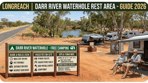
4. Facilities at Longreach Darr River Waterhole Rest Area
| Facility | Available? | Senior Notes |
|---|---|---|
| Toilets | ✅ Yes — pit/drop toilet | Basic. BYO toilet paper, hand sanitiser, torch for night visits. Can be unpleasant in extreme heat. Fly mesh advised. |
| Showers | ❌ No | Use your van’s onboard shower or wait until Longreach/Winton. |
| Potable Water | ❌ No | Fill all tanks in Longreach. Minimum 10L per person per day in outback heat. |
| Dump Point | ❌ No | Nearest dump point: Longreach Showgrounds, Longreach QLD 4730. |
| Power / Electrical Hookup | ❌ No | No 240V power. Bring battery/solar setup. See CPAP section below. |
| BBQ / Fire Rings | ⚠️ Check current fire bans | Fire rings may be present. All fires subject to local fire bans — check qfes.qld.gov.au before lighting. |
| Shade Shelters | ✅ Some shelters + natural shade | Mature trees provide good shade. Arrive early for shaded spots. |
| Tables / Seating | ✅ Picnic tables present | Basic condition. BYO camp chairs for comfort. |
| Bins | ⚠️ May or may not be present | Practice carry-in, carry-out. Take all rubbish with you. |
| Mobile Signal | 📶 Telstra — weak/intermittent | Optus/Vodafone — nil. External antenna may improve Telstra reception. Do not rely on mobile for emergencies. |
| Pets | ✅ Yes — on lead | Keep dogs away from wildlife and waterhole. Snake risk — keep pets close at all times. |
| Caravan / Motorhome Access | ✅ Yes | Flat ground. Large rigs can access and park comfortably. No formal bays — informal parking. |
5. Dump Point, Water & Fuel — Where to Fill Up Near Longreach Darr River Waterhole
There is no dump point, no potable water, and no fuel at the Darr River Waterhole Rest Area. This is non-negotiable preparation: you must arrive fully self-contained.
| Service | Nearest Location | Address & Postcode | GPS | Distance from Rest Area |
|---|---|---|---|---|
| Dump Point | Longreach Showgrounds | Showground Road, Longreach QLD 4730 | -23.4370, 144.2500 | ~85 km south |
| Potable Water | Longreach — multiple locations including caravan parks and visitor info centre | Eagle Street, Longreach QLD 4730 | -23.4360, 144.2500 | ~85 km south |
| Fuel (Longreach) | Multiple service stations in Longreach | Eagle Street, Longreach QLD 4730 | -23.4360, 144.2480 | ~85 km south |
| Fuel (Winton) | Winton service stations | Elderslie Street, Winton QLD 4735 | -22.3930, 143.0380 | ~95 km north |
6. Fires, Generators & Noise Rules at Darr River Waterhole Rest Area
Campfires
Ground fires and fire rings may be present at the rest area. However, all fires in Queensland are subject to local fire bans issued by the Queensland Fire and Emergency Services (QFES). During the dry season (which is precisely when most grey nomads visit), fire bans are common across western Queensland.
Before lighting any fire:
- Check qfes.qld.gov.au for current fire ban status
- Use only fallen dead timber — never cut standing trees
- Keep fires small and fully extinguished before sleeping
- Never leave a fire unattended
Generators
There is no formal generator policy at this rest area. However, the unwritten rule among grey nomads is universal: generators off by 8:00 pm and not before 8:00 am. Some travellers run generators in the middle of the day for airconditioning — this is generally accepted. Running a generator at 6:00 am while your neighbours are sleeping is not.
Noise
This is a shared public space. Music, TV, and conversation should be at respectful volumes after dark. Dogs should not be left barking. If you are the type of traveller who wants silence and solitude, arrive early and park at the edge of the rest area — not in the middle of a communal cluster.
7. Monthly Weather & Best Time to Visit Longreach Darr River Waterhole
The Longreach region has a semi-arid climate. Summers are brutally hot. Winters are mild and dry — which is precisely why 90% of grey nomad traffic through this corridor occurs between May and August.
| Month | Avg Max °C | Avg Min °C | Rain (mm) | Senior Verdict |
|---|---|---|---|---|
| January | 37 | 24 | 70 | ❌ Dangerously hot. Road closures possible. Avoid. |
| February | 36 | 24 | 75 | ❌ Wet season storms. Flooding risk. Avoid. |
| March | 35 | 22 | 45 | ❌ Still very hot. Residual wet season risk. |
| April | 32 | 17 | 20 | ⚠️ Warming down. Early arrivals possible. Flies heavy. |
| May | 27 | 12 | 15 | ✅ Excellent. Comfortable days, cool nights. Season begins. |
| June | 24 | 9 | 10 | ✅ Best month. Cool nights, warm days, dry, low flies. |
| July | 23 | 7 | 10 | ✅ Best month. Can be cold at night — bring warm bedding. |
| August | 26 | 9 | 5 | ✅ Still excellent. Warming up slightly. Peak grey nomad traffic. |
| September | 30 | 14 | 5 | ⚠️ Getting hot. Flies increasing. Manageable for fit travellers. |
| October | 34 | 19 | 20 | ❌ Too hot for most seniors. Heat stress risk. |
| November | 36 | 22 | 35 | ❌ Extreme heat. Storm season starting. Avoid. |
| December | 37 | 24 | 55 | ❌ Peak heat. Dangerous for camping without power. Avoid. |
8. Wildlife & Birdlife at Darr River Waterhole
The Darr River Waterhole is one of the few reliable water sources in this stretch of the Mitchell grass downs, making it a wildlife magnet — particularly during the dry season when surrounding country dries out.
Birds
Birdwatchers will find the waterhole genuinely rewarding. Species commonly sighted include:
- Galahs — large flocks at dawn and dusk
- Corellas — noisy, spectacular roosting flocks
- Budgerigars — in good seasons, fast-moving green clouds over the waterhole
- Wedge-tailed eagles — soaring over the surrounding plains
- Pelicans — when the waterhole is full
- Brolgas — occasionally seen on the open plains nearby
- Emus — frequently seen around the rest area and crossing the highway
- Various honeyeaters, fairy-wrens, and finches in the riverine vegetation
Mammals & Reptiles
- Eastern grey kangaroos — common around the waterhole, especially at dawn and dusk
- Red kangaroos — on the surrounding plains
- Dingoes — present in the area. Do not feed. Secure all food and rubbish.
- Snakes — western brown snakes and king brown (mulga) snakes are present throughout this country. Watch where you step, especially at night. Wear enclosed shoes. Keep a torch handy.
9. Stargazing at Longreach Darr River Waterhole Rest Area
The Darr River Waterhole Rest Area sits in one of Australia’s darkest sky zones. With no town within 85 km, virtually no light pollution reaches this location. On a clear winter night — and winter nights in outback Queensland are almost always clear — the Milky Way stretches from horizon to horizon in a white band so dense it casts a faint shadow.
What you can expect to see with the naked eye:
- The Milky Way — clearly visible core, particularly in June–August when the galactic centre is directly overhead
- The Southern Cross and Pointers — high in the sky, unmistakable
- Magellanic Clouds — both Large and Small visible as fuzzy patches
- Satellites and the International Space Station — visible as moving dots
- Shooting stars — common, especially during the May Eta Aquarids and August Perseids periods
10. History of the Darr River and Longreach District
The Darr River is a tributary of the Thomson River, which flows through Longreach and eventually feeds into the Channel Country and Cooper Creek system — the vast inland drainage network that has shaped the ecology and settlement of central western Queensland for millennia.
The Iningai Aboriginal people are the traditional custodians of the Longreach and Darr River region. Waterholes like this one were critically important to Aboriginal peoples — reliable water in arid country determined travel routes, meeting places, and seasonal camps for thousands of years before European arrival.
European pastoralists arrived in the Longreach district in the 1860s and 1870s, establishing vast sheep and cattle stations across the Mitchell grass downs. The Landsborough Highway — named after explorer William Landsborough, who traversed this country in 1862 searching for the lost Burke and Wills expedition — follows a route that Aboriginal peoples had used for thousands of years before him.
Longreach itself became famous as the birthplace of Qantas (Queensland and Northern Territory Aerial Services), founded there in 1920. The Australian Stockman’s Hall of Fame, opened in Longreach in 1988, tells the broader story of the outback pastoral industry that the Darr River and its waterholes sustained.
The waterhole remains what it has always been — a reliable water source in country where water is the most precious thing there is.
11. Accessibility for Senior Travellers at Darr River Waterhole
| Accessibility Feature | Status | Notes |
|---|---|---|
| Vehicle access | ✅ Good | Sealed highway to the turnoff. Short formed dirt access road — suitable for all vehicles. |
| Ground surface | ⚠️ Variable | Compacted earth. Can be uneven. Not suitable for wheelchair access to waterhole edge. |
| Toilet accessibility | ⚠️ Basic | Pit toilet. Not wheelchair accessible. Narrow doorway. No rails. Step up may be required. |
| Walking paths | ❌ None | No formal paths. Ground is natural earth — uneven, potential trip hazards from tree roots. |
| Lighting | ❌ None | No artificial lighting whatsoever. Bring a headlamp and torch. Essential for night toilet visits. |
| Overall senior suitability | ✅ Suitable with preparation | Self-contained travellers with reasonable mobility will manage well. Those with significant mobility issues may find the ground surface and toilet difficult. |
12. Safety & Emergency Plan — Darr River Waterhole Rest Area
The Darr River Waterhole Rest Area is approximately 85 km from the nearest town (Longreach) and approximately 95 km from Winton. Mobile phone signal is unreliable at best. This means you must have an emergency plan before you arrive.
Emergency Contacts
| Service | Address & Postcode | GPS | Phone |
|---|---|---|---|
| Longreach Hospital | Ilfracombe Road, Longreach QLD 4730 | -23.4310, 144.2530 | 07 4658 4700 |
| Winton Hospital | Cork Street, Winton QLD 4735 | -22.3900, 143.0340 | 07 4657 2200 |
| Longreach Police | Eagle Street, Longreach QLD 4730 | -23.4350, 144.2490 | 07 4658 4200 |
| RFDS (Royal Flying Doctor Service) | Longreach Airport, Longreach QLD 4730 | -23.4340, 144.2800 | Call 000 |
| Emergency — all services | — | — | 000 |
Emergency Scenario Plan
| Scenario | Action |
|---|---|
| Snake bite | Apply pressure immobilisation bandage. Do not cut, suck, or wash the wound. Keep patient still. Activate PLB or flag highway traffic. Nearest antivenom: Longreach Hospital. |
| Heat stroke | Move to shade. Remove excess clothing. Apply cool water to skin. Fan vigorously. Offer small sips of water if conscious. This is a medical emergency — activate PLB. |
| Vehicle breakdown | Stay with your vehicle. Use shade. Conserve water. Place a bright item on the roof for visibility. If no phone signal, wait for passing traffic — the Landsborough Highway has regular daytime traffic during the dry season. |
| Chest pain / cardiac event | Administer aspirin if not allergic. Rest in recovery position if unconscious. Activate PLB immediately. RFDS can reach this location from Longreach Airport within approximately 30–45 minutes. |
| Fire | Evacuate immediately. Move vehicles away from fire zone. Use fire extinguisher only if safe to do so. Drive to the highway and head towards Longreach or Winton. Call 000 if signal available. |
13. CPAP & Medical Power at Longreach Darr River Waterhole Rest Area
There is no 240V power at the Darr River Waterhole Rest Area. If you use a CPAP machine for sleep apnoea — and a significant proportion of senior grey nomads do — this requires advance planning.
| CPAP Power Option | Capacity Needed | Senior Notes |
|---|---|---|
| Dedicated lithium battery (e.g., EcoFlow River 2, Jackery 300+) | 300–500Wh minimum | Most CPAPs draw 30–60W. A 500Wh battery = 2+ nights. Charge fully in Longreach. The most reliable option. |
| Vehicle auxiliary battery (deep cycle + inverter) | 100Ah minimum | Works well if your setup is already installed. Run engine briefly in the morning to recharge if needed. |
| Generator | 1000W minimum | Works but creates noise. Park away from others if running at night. Not the ideal solution in a communal rest area. |
14. Road Conditions — Landsborough Highway (Longreach to Winton)
The Landsborough Highway between Longreach and Winton is a sealed two-lane highway maintained by the Queensland Department of Transport and Main Roads. In normal dry-season conditions, the road is in good condition and suitable for all vehicles including large caravans and motorhomes.
Key road condition notes:
- Single lane in each direction with occasional overtaking lanes
- Road trains use this highway — they are long, fast, and cannot stop quickly
- Cattle and kangaroos on the road are a genuine hazard, especially at dawn and dusk
- After heavy rain, sections of the highway may be closed by floodwaters — particularly creek crossings
- The access road into the rest area is formed dirt — may be slippery after rain
Check road conditions before departing: qldtraffic.qld.gov.au — this is the official Queensland government road conditions website. Check it on the morning of departure.
15. Cooking & Meal Ideas for Self-Contained Camping at Darr River Waterhole
With no shops, no power, and no water at the rest area, your meals need to be planned before you leave Longreach. Here are practical meal ideas tested by grey nomads on the Longreach–Winton run:
| Meal | Suggestion | Notes |
|---|---|---|
| Lunch (arrival day) | Pre-made sandwiches or wraps, fruit, cheese & crackers | Make in Longreach. Keep in cooler. No cooking needed. |
| Dinner | One-pot camp oven stew, chops on gas BBQ, or pre-cooked curry reheated on gas stove | Cook on gas. Pre-cook in Longreach if you prefer minimal effort on site. |
| Breakfast | Bacon & eggs on gas stove, toast on camp toaster, cereal with long-life milk | Keep it simple. Use minimal water for washing up. |
| Sundowner snack | Cheese board, dip & crackers, dried fruit & nuts, a cold drink from the fridge | The sunset at Darr River Waterhole deserves a cheese board. It is that good. |
16. Waste Management & Leave No Trace at Darr River Waterhole
This rest area is maintained by the Longreach Regional Council, but it is not serviced daily. Bins may or may not be present, and when present, they may be full. The golden rule is simple: carry in, carry out.
- Rubbish: Bag all rubbish and take it with you to Longreach or Winton for disposal
- Food scraps: Do not scatter food scraps on the ground — this attracts dingoes, feral pigs, and vermin
- Grey water: If your van has a grey water tank, do not empty it on the ground at the rest area. Hold it until you reach a dump point
- Black water: Absolutely never empty cassette toilets at this rest area. The nearest dump point is at Longreach Showgrounds, Showground Road, Longreach QLD 4730, GPS: -23.4370, 144.2500
- Cigarette butts: Use a portable ashtray. Butts on the ground are litter and a fire risk
17. Rest Area Etiquette for Grey Nomads at Darr River Waterhole
The unwritten rules of Australian rest area camping are simple, but they matter — especially when 10–15 caravans are sharing a finite space:
| Rule | Why |
|---|---|
| Don’t park blocking someone else’s exit | Some travellers leave before dawn. If you block them, you will be woken. |
| Keep dogs on lead and quiet | Barking dogs at 5:00 am annoy everyone. Keep them close and managed. |
| Generators off by 8:00 pm, on no earlier than 8:00 am | The most common complaint at rest areas. Respect it. |
| Don’t spread out your camp across three bays | Space is shared. Chairs and awnings should stay within a reasonable footprint. |
| Say hello to your neighbours | A wave and a “g’day” is both courtesy and safety — you’re looking out for each other. |
| Leave the site cleaner than you found it | Pick up one piece of rubbish that isn’t yours. It takes three seconds. |
| Respect the stay limit (typically 48 hours) | Long-stayers prevent others from using the rest area. Move on after the posted limit. |
COPY PROMPT ➔ ASK AI ➔ SAVE TO FORM ➔ ADD SPOT PIN ➔ GET DIRECTIONS
📍 Interactive map — find free camps, rest areas and overnight stops. Enable location for best results.
18. Van Life Savings Spots: Free and Low-Cost Camping Near Longreach
If the Darr River Waterhole is full, or if you want to compare options, here are other free and low-cost camping options near Longreach. Save all GPS coordinates to your Van Life Savings Spots app before you leave WiFi range.
| Name | Address & Postcode | GPS | Cost | Senior Notes |
|---|---|---|---|---|
| Darr River Waterhole Rest Area | Landsborough Hwy, Darr River QLD 4702 | -22.7290, 144.2660 | Free | This article’s focus. Pit toilet, shade, waterhole. No water/power/dump. |
| Longreach Showgrounds | Showground Road, Longreach QLD 4730 | -23.4370, 144.2500 | Low cost | Basic camping with dump point and water. Check availability during show season. |
| Ilfracombe Rest Area | Landsborough Hwy, Ilfracombe QLD 4727 | -23.4570, 144.4930 | Free | Small rest area near Ilfracombe. Basic facilities. 27 km east of Longreach. |
| Bladensburg National Park | Winton-Jundah Road, Winton QLD 4735 | -22.5110, 143.0690 | National Park fees | Beautiful gorge country near Winton. Book via qld.gov.au/parks. Not free but excellent value. |
19. Nearby Attractions — What to Do in Longreach
Longreach is one of outback Queensland’s premier tourist destinations — and for good reason. Most grey nomads spend 3–5 days in Longreach before or after camping at the Darr River Waterhole. Here are the key attractions:
| Attraction | Address & Postcode | GPS | Senior Notes |
|---|---|---|---|
| Australian Stockman’s Hall of Fame | Landsborough Hwy, Longreach QLD 4730 | -23.4130, 144.2450 | World-class museum. Allow 3–4 hours minimum. Accessible. Café on site. Afternoon stockman show is superb. |
| Qantas Founders Museum | Sir Hudson Fysh Drive, Longreach QLD 4730 | -23.4290, 144.2730 | Walk through a retired 747 and 707. Brilliant for aviation enthusiasts. Allow 2–3 hours. Mostly accessible. |
| Thomson River Sunset Cruise | Departs from Longreach waterfront, Eagle Street, Longreach QLD 4730 | -23.4360, 144.2520 | Paddlesteamer cruise with dinner and show. Book ahead during peak season. Excellent value. |
| Longreach School of Distance Education | Ibis Street, Longreach QLD 4730 | -23.4340, 144.2530 | Free tours during term time. See how outback children are educated. Fascinating and moving. |
| Winton — Australian Age of Dinosaurs Museum | Dinosaur Drive, Winton QLD 4735 | -22.3170, 143.0730 | World-class dinosaur museum on a mesa top. 95 km north of Darr River. Book ahead. Allow half a day. |
| Winton — Waltzing Matilda Centre | 50 Elderslie Street, Winton QLD 4735 | -22.3930, 143.0370 | Museum celebrating Banjo Paterson and the story of Waltzing Matilda. Accessible. Allow 1–2 hours. |
20. Longreach Darr River Waterhole vs Other Outback Rest Areas
How does the Darr River Waterhole compare to other popular outback rest areas used by grey nomads?
| Feature | Darr River Waterhole | Bladensburg NP (Winton) | Ilfracombe Rest Area |
|---|---|---|---|
| Cost | Free | Park fees apply | Free |
| Toilets | Yes — pit | Yes — composting | Yes — pit |
| Water | No | No | No |
| Scenery | Waterhole + coolabahs — excellent | Gorge country — spectacular | Roadside — basic |
| Wildlife | Excellent — waterhole attracts birds and kangaroos | Excellent — wallaroos, birds of prey | Limited |
| Stargazing | Outstanding — no nearby light pollution | Outstanding | Good |
| Overall Senior Rating | ⭐⭐⭐⭐ (4/5) | ⭐⭐⭐⭐⭐ (5/5) | ⭐⭐ (2/5) |
21. Senior Packing Checklist — Longreach Darr River Waterhole Rest Area
| Item | Why It Matters for Darr River Waterhole | ✓ |
|---|---|---|
| Full water tanks | No potable water at the rest area. Minimum 10L per person per day. Fill in Longreach. | ☐ |
| Full fuel tank | No fuel between Longreach and Winton. 180 km stretch. | ☐ |
| Toilet paper + hand sanitiser | Pit toilet may not have supplies. BYO always. | ☐ |
| Torch / headlamp | No lighting at the rest area. Essential for night toilet visits and snake avoidance. | ☐ |
| Fly net / head net | Outback flies in April–May and September can be relentless. A $5 head net saves your sanity. | ☐ |
| Warm bedding | Winter nights drop to 5–10°C. Doona or good sleeping bag rated to 0°C. | ☐ |
| PLB registered with AMSA | No reliable phone signal. Free registration at beacons.amsa.gov.au. | ☐ |
| First aid kit with pressure bandage | Snake country. Know how to apply a pressure immobilisation bandage. | ☐ |
| CPAP battery (if applicable) | No 240V power. See CPAP section above. Charge fully in Longreach. | ☐ |
| Enclosed shoes | Snake and spider protection. Never walk barefoot at an outback rest area. | ☐ |
| Binoculars | Birdwatching at the waterhole + stargazing at night. 7×50 or 10×50 recommended. | ☐ |
| Rubbish bags | Carry in, carry out. No guaranteed bin service. | ☐ |
| Camp chairs + small table | Picnic tables may be limited. BYO for sunset comfort. | ☐ |
| Prescription medications (extra supply) | Nearest pharmacy is Longreach — 85 km. Always carry extra days of medication. | ☐ |
22. Grey Nomad Reviews — What Travellers Say About Darr River Waterhole
Based on publicly available reviews from WikiCamps AU, travel forums, and grey nomad community feedback, here is what travellers consistently say about the Darr River Waterhole Rest Area:
| What Travellers Like | What Travellers Warn About |
|---|---|
| Beautiful waterhole setting — sunsets are spectacular | Toilet can be unpleasant in peak season — not always clean |
| Flat ground — easy to park and level a caravan | Flies can be intense in shoulder months (April, September) |
| Excellent birdwatching — especially galahs and corellas at dusk | No water — must be fully self-contained |
| Night sky is breathtaking — one of the best free stargazing spots | Gets busy in peak season — arrive early |
| Friendly communal atmosphere with other grey nomads | Road train noise if parked close to the highway |
| Free — no fee, no booking, no hassle | Snakes are present — be vigilant, especially at night |
23. GPS Coordinates & Postcodes — Longreach Darr River Waterhole: Save Every Stop
Copy every GPS coordinate below into your Van Life Savings Spots app before you leave WiFi range. In outback Queensland with limited phone signal, pre-saved GPS is your lifeline.
| Location | Address & Postcode | GPS |
|---|---|---|
| Darr River Waterhole Rest Area | Landsborough Hwy, Darr River QLD 4702 | -22.7290, 144.2660 |
| Longreach Showgrounds (Dump Point) | Showground Road, Longreach QLD 4730 | -23.4370, 144.2500 |
| Longreach Fuel (town centre) | Eagle Street, Longreach QLD 4730 | -23.4360, 144.2480 |
| Longreach Hospital | Ilfracombe Road, Longreach QLD 4730 | -23.4310, 144.2530 |
| Longreach Police | Eagle Street, Longreach QLD 4730 | -23.4350, 144.2490 |
| Longreach Library (Free WiFi) | 96 Eagle Street, Longreach QLD 4730 | -23.4355, 144.2495 |
| Australian Stockman’s Hall of Fame | Landsborough Hwy, Longreach QLD 4730 | -23.4130, 144.2450 |
| Qantas Founders Museum | Sir Hudson Fysh Drive, Longreach QLD 4730 | -23.4290, 144.2730 |
| Winton — Australian Age of Dinosaurs | Dinosaur Drive, Winton QLD 4735 | -22.3170, 143.0730 |
| Winton — Waltzing Matilda Centre | 50 Elderslie Street, Winton QLD 4735 | -22.3930, 143.0370 |
| Winton Hospital | Cork Street, Winton QLD 4735 | -22.3900, 143.0340 |
| Winton Fuel | Elderslie Street, Winton QLD 4735 | -22.3930, 143.0380 |
| Ilfracombe Rest Area | Landsborough Hwy, Ilfracombe QLD 4727 | -23.4570, 144.4930 |
| Bladensburg National Park | Winton-Jundah Road, Winton QLD 4735 | -22.5110, 143.0690 |
| RFDS Longreach Airport | Longreach Airport, Longreach QLD 4730 | -23.4340, 144.2800 |
24. Frequently Asked Questions — Longreach Darr River Waterhole Rest Area for Grey Nomads
Is Darr River Waterhole Rest Area free to camp at overnight?
Yes. Darr River Waterhole Rest Area is a free designated rest stop on the Landsborough Highway, approximately 85 km north of Longreach QLD. No booking, no permit, and no fee. First come, first served. Check signage on arrival for the current stay limit (typically 48 hours). GPS: -22.7290, 144.2660.
Are there toilets at Darr River Waterhole Rest Area?
Yes — a basic pit/drop toilet is available. There are no showers. Carry your own toilet paper, hand sanitiser, and a torch for night visits. The toilet condition can vary — particularly during peak season when usage is high and servicing may be infrequent.
Is there a dump point at Darr River Waterhole?
No. There is no dump point at the rest area. The nearest dump point is at Longreach Showgrounds, Showground Road, Longreach QLD 4730, GPS: -23.4370, 144.2500 — approximately 85 km south. Empty your cassette in Longreach before heading north.
Can I get water at Darr River Waterhole Rest Area?
No potable water is available at the rest area. The waterhole water is untreated and shared with livestock and wildlife — it is not safe to drink. Fill all water tanks in Longreach before departing. Minimum 10 litres per person per day in outback conditions.
Are there snakes at Darr River Waterhole?
Yes. Western brown snakes and king brown (mulga) snakes are present throughout this region. A waterhole attracts wildlife — including snakes seeking water and prey. Wear enclosed shoes at all times. Use a torch at night. Check shoes and bedding. Keep a pressure immobilisation bandage in your first aid kit. The nearest antivenom is at Longreach Hospital, Ilfracombe Road, Longreach QLD 4730, GPS: -23.4310, 144.2530, phone 07 4658 4700.
What is the nearest hospital to Darr River Waterhole?
Longreach Hospital — Ilfracombe Road, Longreach QLD 4730, GPS: -23.4310, 144.2530, phone 07 4658 4700. Approximately 85 km south. For life-threatening emergencies, call 000. RFDS retrieval is available via Longreach Airport.
Is Darr River Waterhole safe for solo senior travellers?
During the dry season (May–August), the rest area typically has multiple other caravans and motorhomes, providing communal safety. There are no lights, no management, and no security. Solo seniors should park near other travellers, keep a torch and phone accessible, lock doors at night, carry a PLB registered with AMSA, and ensure someone knows their itinerary. Read our guide on caravan security for grey nomads.
Are dogs allowed at Darr River Waterhole Rest Area?
Yes — dogs are allowed on lead at all times. Keep dogs away from the waterhole edge (snake risk) and away from wildlife. Do not let dogs roam — dingoes are present in the area and interactions can be dangerous for small dogs.
What phone signal is available at Darr River Waterhole?
Telstra signal is weak to intermittent. Optus and Vodafone have no coverage. An external antenna may improve Telstra reception slightly. A PLB registered with AMSA and a satellite communicator such as a Garmin inReach are strongly recommended. Do not rely on a mobile phone for emergency communication at this location.
What is the best time of year to visit Darr River Waterhole?
June and July are the best months — cool nights (7–12°C), warm days (23–27°C), virtually no rain, low humidity, and minimal flies. May and August are also excellent. Avoid October through March — extreme heat (35–40°C+), potential flooding, and fly plagues make travel unpleasant and potentially dangerous.
Can I use a CPAP machine at Darr River Waterhole without power?
There is no 240V power at the rest area. CPAP users must bring a dedicated lithium battery (e.g., EcoFlow River 2, Jackery 300+). Most CPAP machines draw 30–60W, so a 500Wh battery will run your machine for 2+ nights. Turn off the heated humidifier to halve power draw. Charge fully in Longreach before departing. This is a non-negotiable safety item for seniors with sleep apnoea.
How far is Darr River Waterhole from Longreach?
Approximately 85 km north of Longreach on the Landsborough Highway. The drive takes approximately 55 minutes when towing a caravan. The road is sealed the entire distance. GPS: -22.7290, 144.2660.
Is Darr River Waterhole suitable for large caravans and motorhomes?
Yes. The rest area has flat, open ground suitable for large caravans, motorhomes, and camper trailers. The access from the Landsborough Highway is straightforward. No formal bays — you park informally. Check ground firmness after recent rain.
Where is the nearest fuel to Darr River Waterhole?
Nearest fuel south: Longreach (approximately 85 km, multiple service stations). Nearest fuel north: Winton (approximately 95 km). There is no fuel between Longreach and Winton. Always fill up in Longreach before heading north — this is a 180 km stretch with no services.
Can I swim in the Darr River Waterhole?
This is not recommended. The waterhole is untreated and shared with livestock and wildlife. Water quality is unknown and may contain blue-green algae, livestock contamination, or parasites. There are no lifeguards, no safety equipment, and no guaranteed depth visibility. If you choose to enter the water, you do so at your own risk.
25. Quick-Reference Card & Final Verdict — Longreach Darr River Waterhole Rest Area
Screenshot this table and save it to your phone. When you have no signal 85 km north of Longreach, this is what you need:
| 📋 DARR RIVER WATERHOLE REST AREA — QUICK-REFERENCE CARD | |
|---|---|
| GPS | -22.7290, 144.2660 |
| Address | Landsborough Highway, Darr River QLD 4702 |
| Cost | Free |
| Stay Limit | 48 hours (check signage) |
| Toilets | Yes — pit toilet. BYO paper. |
| Showers / Water / Power | No / No / No |
| Dump Point | Longreach Showgrounds — GPS: -23.4370, 144.2500 |
| Nearest Fuel | Longreach (~85 km S) or Winton (~95 km N) |
| Nearest Hospital | Longreach Hospital — 07 4658 4700 — GPS: -23.4310, 144.2530 |
| Emergency | 000 (if signal). Otherwise activate PLB. |
| Phone Signal | Telstra weak/intermittent. Optus/Vodafone nil. Carry PLB. |
| Pets | Yes — on lead |
| Best Months | June & July. May & August also good. |
| Senior Rating | ⭐⭐⭐⭐ (4/5) — Excellent free stop with genuine outback beauty |
Final Verdict
The Longreach Darr River Waterhole Rest Area is one of the genuinely rewarding free overnight stops in outback Queensland. It is not a caravan park — there are no showers, no power, no water, and no dump point. But what it delivers is something no caravan park can sell: a real outback waterhole, a sunset that turns coolabahs into silhouettes against a burning sky, a night sky packed with stars from horizon to horizon, and the sound of corellas coming home to roost at dusk.
For self-contained senior grey nomads living on the road, this is the kind of place you remember. Fill your tanks in Longreach, arrive by early afternoon, claim a shaded spot near the waterhole, and settle in for one of the best free evenings on the Landsborough Highway.
Save GPS: -22.7290, 144.2660 to your Van Life Savings Spots app now. You won’t regret the stop.
Free campsites and powered sites fill fast during school holidays and peak season. If your preferred site is already gone, search remaining accommodation options below to explore the region.
Accommodation and flight search powered by Expedia. Booking through this search supports this website at no extra cost to you. As an affiliate, I earn from qualifying purchases at no extra cost to you.

As an affiliate, I earn from qualifying purchases at no extra cost to you.
As an affiliate, I earn from qualifying purchases at no extra cost to you.