Kununurra Highway Rest Area — Free Camping Senior Grey Nomad Guide 2026
📑 Table of Contents
- 1. Kununurra and the East Kimberley — Why Grey Nomads Drive This Far
- 2. Free Highway Rest Area — Convenient, But Genuinely Hard for Seniors
- 3. Your Two Main Options Side by Side
- 4. Kununurra Highway Rest Area: Quick Facts and What You Get
- 5. Shade and Heat Management — What 40°C Means at a Rest Area
- 6. What Kununurra Highway Rest Area Doesn’t Tell You Online
- 7. Van Life Savings Spots: Free and Low-Cost Camping Near Kununurra
- 7b. Dump Points Near Kununurra Highway Rest Area
- 7c. Free Water Near Kununurra Highway Rest Area
- 8. Kimberleyland Holiday Park — The Powered Alternative for Grey Nomads
- 9. Full Facilities Comparison: Rest Area vs Kimberleyland vs Free Camps
- 10. Rates: All Options Near Kununurra
- 11. The East Kimberley Day Plan for Seniors
- 12. Senior Checklist: Kununurra and East Kimberley
- 13. What to Do in Kununurra: Your Senior Day Plan
- 14. GPS Coordinates and Postcodes: Save Every Stop
- 15. Frequently Asked Questions — Kununurra Highway Rest Area for Grey Nomads
- 16. Quick-Reference Card + Booking CTAs
1. Kununurra and the East Kimberley — Why Grey Nomads Drive This Far
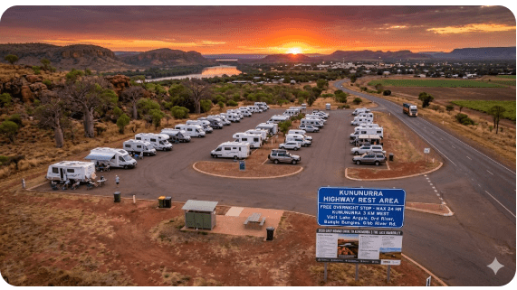
The Kununurra Highway Rest Area sits on Victoria Highway approximately 3 km east of the Kununurra town centre in Western Australia’s East Kimberley. For senior grey nomads arriving from the Northern Territory border — often after a gruelling 500 km stretch from Katherine — this rest area is the first free overnight stop inside WA that does not require leaving the highway. In 2026, it remains one of the most searched free camping options near Kununurra for grey nomads driving the top end route.
Kununurra is the gateway to Lake Argyle, the Ord River, El Questro, the Bungle Bungles (Purnululu National Park) and the start — or end — of the Gibb River Road. It is a town with a real hospital, supermarkets, fuel and services. The rest area gives you free proximity to all of this. But proximity and comfort are not the same thing, and for seniors with CPAP machines, mobility concerns and heat sensitivity, the difference matters.
2. Free Highway Rest Area — Convenient, But Genuinely Hard for Seniors
The Kununurra Highway Rest Area looks like an easy win: free, close to town and right on the highway. Many travellers use it as a convenient overnight stop. But here is what the GPS pin on WikiCamps does not tell you about the reality for seniors in 2026:
- No power. Zero 240V outlets. If you rely on a CPAP machine, you need a fully charged lithium battery or a generator — and generator noise at a highway rest area is a problem for everyone.
- No water. There is no potable water tap. You arrive with what you carry.
- No toilets on-site. The rest area itself has no toilet block. You rely entirely on your own onboard facilities.
- No shade structures. Kununurra regularly hits 38–42°C from September to March. Sitting in an unshaded van in that heat is not camping — it is dangerous, especially for seniors on blood pressure medication.
- Highway noise. Road trains run the Victoria Highway 24 hours. Light sleepers — and anyone with hearing aids — will struggle.
3. Your Two Main Options Side by Side
| Feature | Kununurra Highway Rest Area (Free) | Kimberleyland Holiday Park (Paid) |
|---|---|---|
| Cost | Free | From ~$45–$55/night powered |
| Booking Required | No — first come, first served | Yes — essential in dry season |
| 240V Power | ❌ None | ✅ Yes — powered sites |
| Pool / Shade | ❌ No pool, minimal shade | ✅ Pool + shaded sites |
| Potable Water | ❌ No | ✅ Yes — on-site taps |
| Toilets / Showers | ❌ None on-site | ✅ Clean amenities block |
| Dump Point | ❌ No — nearest 3 km in town | ✅ On-site |
| Dogs | ✅ Yes — on lead | ✅ Yes — check conditions |
| Phone Signal (Telstra) | ✅ Good — near town | ✅ Good |
| Nearest Hospital | ~4 km — Kununurra Hospital | ~2 km — Kununurra Hospital |
| Senior Recommendation | ⚠️ One night max — transit stop only | ✅ Best for multi-night base in dry season |
4. Kununurra Highway Rest Area: Quick Facts and Proximity to Town
| Detail | Information |
|---|---|
| Official Name | Kununurra Highway Rest Area |
| Location | Victoria Highway, Kununurra WA 6743 |
| GPS | -15.7560, 128.7560 |
| Cost | Free — no permit required |
| Stay Limit | 24 hours maximum |
| Permit / Fee | No permit required. No fee. Managed by Main Roads WA. |
| Power | ❌ None |
| Potable Water | ❌ None |
| Toilets | ❌ None on-site |
| Dump Point | ❌ Not on-site — nearest at Kununurra Visitor Centre ~3 km |
| Surface | Gravel / hard-packed dirt — generally level |
| Suitable for Big Rigs | ✅ Yes — easy pull-off, room for caravans |
| Dogs | ✅ Allowed on lead |
| Phone Signal | Telstra ✅ Good | Optus ⚠️ Variable |
| Nearest Hospital | Kununurra Hospital, 90 Coolibah Drive, Kununurra WA 6743 — GPS: -15.7734, 128.7373 — 08 9168 1522 — approx 4 km |
| Nearest Fuel | Kununurra town centre — ~3 km |
| Public WiFi Nearby | Kununurra Public Library, Coolibah Drive, Kununurra WA 6743 — free WiFi during opening hours |
5. Shade and Heat Management — What 40°C Means at a Rest Area
Kununurra’s dry season (May–September) is beautiful — warm days around 30–33°C, cool nights around 15–18°C. This is when most seniors living on the road in retirement pass through. But the build-up (October–November) and wet season (December–March) push temperatures above 40°C with humidity that makes a van feel like a sauna.
At the Kununurra Highway Rest Area, there are some scattered trees but no engineered shade structures. By 10 am in October, the van interior can exceed 45°C. Without power for air conditioning or even a fan, this is not a comfort issue — it is a health emergency waiting to happen for anyone on heart medication, blood pressure tablets or diuretics.
6. What Kununurra Highway Rest Area Doesn’t Tell You Online
Most online listings give you a GPS pin and a note saying “free camping.” Here is what experienced grey nomads who have actually stopped here in 2026 want you to know:
- Road train noise is constant. The Victoria Highway carries heavy freight 24/7. If you are a light sleeper, bring earplugs. This is not a quiet bush camp.
- Crocs are real in this region. Do not walk dogs near any waterway. Do not let children or dogs near drainage channels. Saltwater crocodiles are present throughout the Kununurra region — including in irrigation channels near the highway.
- The rest area can get crowded in peak season (June–August). When it fills, vans park tightly. Reversing a big rig out at dawn with other vehicles close by is stressful for seniors who struggle with tight manoeuvres.
- No security or lighting. There is no caretaker, no CCTV, and limited lighting. Solo women travellers report feeling exposed. If this concerns you, a caravan park with other travellers nearby is the safer choice. See our guide on grey nomad security on the road.
- Telstra signal is good here — you are only 3 km from the Kununurra tower. This is one of the few free rest areas in the Kimberley with reliable phone coverage.
COPY PROMPT ➔ ASK AI ➔ SAVE TO FORM ➔ ADD SPOT PIN ➔ GET DIRECTIONS
📍 Interactive map — find free camps, rest areas and overnight stops. Enable location for best results.
7. Van Life Savings Spots: Free and Low-Cost Camping Near Kununurra
Use the Van Life Savings Spots app to find and save every free camp near Kununurra with GPS — including ones that do not appear on WikiCamps. Try AI queries like:
- “Free camping near Kununurra WA with toilets”
- “Rest areas between Katherine and Kununurra with shade”
- “Dump point locations near Kununurra 2026”
- “Senior-friendly free camps East Kimberley”
| Camp Name | Cost | Address / Postcode | GPS | Distance from Rest Area | Senior Verdict |
|---|---|---|---|---|---|
| Kununurra Highway Rest Area | Free | Victoria Highway, Kununurra WA 6743 | -15.7560, 128.7560 | — | ⚠️ One night transit only — no water, no toilet, no power |
| Celebrity Tree Park | Free | Coolibah Drive, Kununurra WA 6743 | -15.7750, 128.7380 | ~3 km | ✅ In town, good shade from boab trees, toilets nearby — check Shire signs for current camping rules |
| Ivanhoe Crossing Rest Area | Free | Ivanhoe Road, Kununurra WA 6743 | -15.7230, 128.7070 | ~10 km | ⚠️ Scenic — croc warning at water. Day visit only recommended for seniors. Check current access — road can be rough. |
| Lake Argyle Overflow Camping | Free (overflow area) | Lake Argyle Road, Lake Argyle WA 6743 | -16.1080, 128.7420 | ~70 km | ⚠️ Stunning views but remote. No facilities. Self-contained only. Long drive on sealed road. |
7b. Dump Points Near Kununurra Highway Rest Area
| 🗑️ Dump Point | Location / Address | GPS | Distance from Rest Area | Notes |
|---|---|---|---|---|
| Before — Timber Creek Rest Area Dump Point | Victoria Highway, Timber Creek NT 0852 | -15.6600, 130.4800 | ~220 km east (NT side) | Free public dump point — last chance before WA border |
| On-site | Kununurra Highway Rest Area | -15.7560, 128.7560 | — | ❌ No dump point on-site |
| After — Kununurra Visitor Centre Dump Point | Coolibah Drive, Kununurra WA 6743 | -15.7746, 128.7375 | ~3 km west | Free public dump point — well signed, easy access for big rigs |
| After — Kimberleyland Holiday Park | Lakeview Drive, Kununurra WA 6743 | -15.7630, 128.7200 | ~5 km west | On-site dump point — for guests or by arrangement |
7c. Free Water Near Kununurra Highway Rest Area
| 💧 Water Source | Location / Address | GPS | Distance from Rest Area | Notes |
|---|---|---|---|---|
| On-site | Kununurra Highway Rest Area | -15.7560, 128.7560 | — | ❌ No water on-site |
| Kununurra Visitor Centre Water Tap | Coolibah Drive, Kununurra WA 6743 | -15.7746, 128.7375 | ~3 km west | Free potable water — fill tanks here on your way through town |
| Kununurra Fuel Stations | Coolibah Drive / Konkerberry Drive, Kununurra WA 6743 | -15.7730, 128.7360 | ~3 km | Ask at the counter — most allow water fill if purchasing fuel |
8. Kimberleyland Holiday Park — The Powered Alternative for Grey Nomads
If you need power, shade, a pool and a proper dump point, Kimberleyland Holiday Park is the most popular senior choice in Kununurra in 2026. It sits on the shore of Lake Kununurra (Lily Creek Lagoon) and offers powered sites, cabins, a swimming pool, camp kitchen and clean amenities.
Address: Lakeview Drive, Kununurra WA 6743
GPS: -15.7630, 128.7200
Phone: 08 9168 1031
Website: kimberleyland.com.au
9. Full Facilities Comparison: Kununurra Highway Rest Area vs Kimberleyland vs Free Camps
| Facility | Highway Rest Area | Kimberleyland | Celebrity Tree Park |
|---|---|---|---|
| Power | ❌ | ✅ | ❌ |
| Toilets / Showers | ❌ | ✅ | ⚠️ Public toilets nearby |
| Pool | ❌ | ✅ | ❌ |
| Dining / Camp Kitchen | ❌ | ✅ | ❌ |
| Wi-Fi | ❌ (Telstra mobile only) | ⚠️ Limited | ❌ (Library nearby) |
| Dump Point | ❌ | ✅ | ❌ (Visitor Centre ~500 m) |
| Dogs | ✅ | ✅ (conditions apply) | ✅ On lead |
| Phone Coverage | ✅ Good Telstra | ✅ Good | ✅ Good — in town |
| Medical Proximity | ~4 km | ~2 km | ~1 km |
| Senior Overall Rating | ⚠️ Transit only | ✅ Best for seniors | ⚠️ Check rules — in town |
10. Rates: All Options Near Kununurra in 2026
| Option | Rate (2026 approx.) | Book / Contact |
|---|---|---|
| Kununurra Highway Rest Area | Free — 24 hr limit | No booking needed |
| Celebrity Tree Park | Free — check Shire rules | No booking — first come |
| Kimberleyland Holiday Park — Powered Site ← Senior Recommended | ~$45–$55/night (2 adults, powered) | 08 9168 1031 | kimberleyland.com.au |
| Discovery Parks — Kununurra (Lake Kununurra) | ~$50–$65/night powered | 08 9168 1031 | discoveryholidayparks.com.au |
Rates are approximate for 2026. Dry season (May–September) rates are higher. Always confirm directly with the park before arriving. Ask about senior or weekly discounts.
11. The East Kimberley Day Plan for Seniors
This plan assumes you are based in Kununurra (at the rest area or in town). Adjust times for heat — in the dry season, mornings are pleasant but afternoons can still be warm.
| Time | Activity | GPS / Location |
|---|---|---|
| 6:30 am | Fill water tanks + dump cassette at Visitor Centre | Coolibah Drive, Kununurra WA 6743 — GPS: -15.7746, 128.7375 |
| 7:00 am | Walk along Celebrity Tree Park — boab trees, flat path | Coolibah Drive, Kununurra WA 6743 — GPS: -15.7750, 128.7380 |
| 8:30 am | Breakfast at Kununurra café or self-cater | Konkerberry Drive, Kununurra WA 6743 |
| 9:30 am | Drive to Kelly’s Knob Lookout — panoramic views of town and ranges | Kelly Road, Kununurra WA 6743 — GPS: -15.7660, 128.7290 |
| 11:00 am | Return to camp or caravan park — heat management, rest, pool | — |
| 4:00 pm | Sunset at Lily Creek Lagoon — bring binoculars for birdlife | Lakeview Drive, Kununurra WA 6743 — GPS: -15.7640, 128.7210 |
12. Senior Checklist: Kununurra and East Kimberley
| Item | Why It Matters for Kununurra | ✓ |
|---|---|---|
| Travel insurance with medical evacuation | Nearest major hospital with full surgical capability is in Darwin — over 800 km. RFDS evacuation is the reality for serious emergencies. Insurance with aeromedical cover is essential. | ☐ |
| PLB registered with AMSA | Phone signal drops out on the Gibb River Road and at Purnululu. If you plan any day trip beyond town, a PLB is your only reliable emergency contact. Free registration at beacons.amsa.gov.au. | ☐ |
| 2-week prescription medication supply | Kununurra has a pharmacy but stock is limited and specialty medications may not be available. Fill prescriptions before leaving Darwin, Broome or Katherine. | ☐ |
| Medicare card + medication list in waterproof pouch | Keep in glove box — not buried in luggage. Printed medication list saves time in an emergency at Kununurra Hospital. | ☐ |
| Full water tanks | No water at the rest area. Fill at Kununurra Visitor Centre dump point area — GPS: -15.7746, 128.7375. Always top up before leaving town. | ☐ |
| Sunscreen SPF 50+ and sun hat | Kununurra’s UV index is extreme year-round. Wear SPF 50+ even in shade. Reapply every 2 hours. | ☐ |
| Offline maps downloaded | Download Google Maps offline for the entire Kununurra-Lake Argyle-Purnululu region while you have Wi-Fi in town. No signal on the Gibb River Road. | ☐ |
| CPAP lithium battery (100Ah minimum) | No power at the rest area. Fully charge at a powered site before staying unpowered. Test your battery runtime before the trip. | ☐ |
| Emergency numbers saved offline + paper in glovebox | Kununurra Hospital: 08 9168 1522. Police: 08 9166 1200. RFDS: 1800 625 800. | ☐ |
| Dump point GPS — before | Timber Creek dump point (NT) — GPS: -15.6600, 130.4800 | ☐ |
| Dump point GPS — after | Kununurra Visitor Centre — GPS: -15.7746, 128.7375 | ☐ |
| Water top-up location saved | Kununurra Visitor Centre — GPS: -15.7746, 128.7375 | ☐ |
| Dog water, lead and tie-out | Dogs on lead at all times. Do NOT let dogs near waterways — saltwater crocodiles are present. Purnululu NP does not allow dogs. | ☐ |
13. What to Do in Kununurra: Your Senior Activity Guide
| Activity | Address / GPS | Senior Notes |
|---|---|---|
| Ord River Cruise | Departs Lake Argyle or Kununurra — book via Triple J Tours — 08 9168 2682 | Seated, shaded boat. Excellent for seniors with mobility issues. Book ahead. |
| Kelly’s Knob Lookout | Kelly Road, Kununurra WA 6743 — GPS: -15.7660, 128.7290 | Drive to the top — short flat walk to viewing area. Best at sunrise or sunset. |
| Celebrity Tree Park Walk | Coolibah Drive, Kununurra WA 6743 — GPS: -15.7750, 128.7380 | Flat, shaded path among boab trees. Good for early morning walk. Under 1 km. |
| Mirima (Hidden Valley) National Park | Mirima National Park Road, Kununurra WA 6743 — GPS: -15.7610, 128.7480 | Mini Bungle Bungles — 2 km from town. Short walks available. WA Parks Pass required ($15/vehicle/day or $30 holiday pass). Buy online at exploreparks.dbca.wa.gov.au or at Kununurra Visitor Centre. |
| Kununurra Museum | Coolibah Drive, Kununurra WA 6743 — GPS: -15.7740, 128.7370 | Air-conditioned. Small but interesting history of the Ord River Scheme. Good afternoon option when it is too hot outside. |
| Waringarri Aboriginal Arts Centre | 16 Speargrass Road, Kununurra WA 6743 — GPS: -15.7780, 128.7310 | Air-conditioned gallery. First Nations art. Free to browse. Good for hot afternoon. |
| Lake Argyle Day Trip | Lake Argyle Road, Lake Argyle WA 6743 — GPS: -16.1180, 128.7430 | 70 km drive on sealed road. Infinity pool at Lake Argyle Resort. Dam wall viewing. Allow a full day. |
| Ivanhoe Crossing | Ivanhoe Road, Kununurra WA 6743 — GPS: -15.7230, 128.7070 | Scenic drive — DO NOT swim or wade. Crocs present. View from the bank only. Road may be rough — check conditions. |
14. GPS Coordinates and Postcodes: Save Every Stop
Save all of these to your Van Life Savings Spots app before you leave phone signal. Once you head towards the Gibb River Road or Purnululu, your phone may not work. Save now.
| Stop | Full Address + Postcode | GPS (copy to app) |
|---|---|---|
| Kununurra Highway Rest Area | Victoria Highway, Kununurra WA 6743 | -15.7560, 128.7560 |
| 🗑️ Kununurra Visitor Centre Dump Point | Coolibah Drive, Kununurra WA 6743 | -15.7746, 128.7375 |
| 💧 Kununurra Visitor Centre Water | Coolibah Drive, Kununurra WA 6743 | -15.7746, 128.7375 |
| 🗑️ Timber Creek Dump Point (NT — before) | Victoria Highway, Timber Creek NT 0852 | -15.6600, 130.4800 |
| Kimberleyland Holiday Park | Lakeview Drive, Kununurra WA 6743 | -15.7630, 128.7200 |
| Celebrity Tree Park | Coolibah Drive, Kununurra WA 6743 | -15.7750, 128.7380 |
| Ivanhoe Crossing | Ivanhoe Road, Kununurra WA 6743 | -15.7230, 128.7070 |
| Kelly’s Knob Lookout | Kelly Road, Kununurra WA 6743 | -15.7660, 128.7290 |
| Mirima (Hidden Valley) National Park | Mirima NP Road, Kununurra WA 6743 | -15.7610, 128.7480 |
| Waringarri Aboriginal Arts | 16 Speargrass Road, Kununurra WA 6743 | -15.7780, 128.7310 |
| Lake Argyle Resort | Lake Argyle Road, Lake Argyle WA 6743 | -16.1180, 128.7430 |
| Lake Argyle Overflow Camping | Lake Argyle Road, Lake Argyle WA 6743 | -16.1080, 128.7420 |
| Kununurra Museum | Coolibah Drive, Kununurra WA 6743 | -15.7740, 128.7370 |
| 🏥 Kununurra Hospital | 90 Coolibah Drive, Kununurra WA 6743 | -15.7734, 128.7373 |
| 🏥 Kununurra Police Station | Coolibah Drive, Kununurra WA 6743 | -15.7720, 128.7350 |
| Kununurra Public Library (free WiFi) | Coolibah Drive, Kununurra WA 6743 | -15.7738, 128.7368 |
15. Frequently Asked Questions — Kununurra Highway Rest Area for Grey Nomads
Is the Kununurra Highway Rest Area free camping?
Yes. The Kununurra Highway Rest Area is free to use with no permit required. It is managed by Main Roads WA. The maximum stay is 24 hours. There are no fees and no booking.
Does the Kununurra Highway Rest Area have toilets?
No. There are no toilet facilities on-site. You must be self-contained or drive approximately 3 km into Kununurra town to use public facilities near the Visitor Centre on Coolibah Drive, Kununurra WA 6743 — GPS: -15.7746, 128.7375.
Is there a dump point at the Kununurra Highway Rest Area?
No. The nearest free public dump point is at the Kununurra Visitor Centre, Coolibah Drive, Kununurra WA 6743 — GPS: -15.7746, 128.7375 — approximately 3 km west.
Can I get water at the Kununurra Highway Rest Area?
No. There is no potable water on-site. Fill your tanks at the Kununurra Visitor Centre water tap — same location as the dump point — GPS: -15.7746, 128.7375.
Is the Kununurra Highway Rest Area safe for solo senior women travellers?
The rest area has no lighting, no caretaker and no CCTV. It is beside a busy highway with road train traffic at night. Solo women travellers report feeling exposed. If safety is a concern, a caravan park in town with other travellers nearby is the better choice. See our grey nomad security guide.
Is there phone signal at the Kununurra Highway Rest Area?
Yes. Telstra coverage is good — you are only about 3 km from the Kununurra tower. Optus coverage is variable. This is one of the few Kimberley free camps with reliable signal.
Where is the nearest hospital to the Kununurra Highway Rest Area?
Kununurra Hospital, 90 Coolibah Drive, Kununurra WA 6743 — GPS: -15.7734, 128.7373 — phone 08 9168 1522. Approximately 4 km drive. For serious emergencies, RFDS evacuation to Darwin may be required. Ensure your travel insurance includes aeromedical evacuation.
Do I need a permit for Mirima National Park near Kununurra?
Yes. A WA Parks Pass is required. Purchase online at exploreparks.dbca.wa.gov.au, at the Kununurra Visitor Centre, or at selected fuel stations. A day pass costs $15/vehicle. A 4-week Holiday Park Pass ($30) is better value if you are spending time in the Kimberley.
Can I take my dog to the Kununurra Highway Rest Area?
Yes — dogs are welcome at the rest area on lead. However, do NOT let dogs near any waterway in the Kununurra region. Saltwater crocodiles are present in all waterways, including irrigation channels. Dogs are not permitted in national parks including Mirima and Purnululu.
How long can I stay at a caravan park in Kununurra?
Most caravan parks in WA allow stays of up to 3 months. For more detail, see our guide on how long you can stay in a caravan park in Australia.
16. Quick-Reference Card
| Detail | Information |
|---|---|
| Rest Area | Kununurra Highway Rest Area |
| Address | Victoria Highway, Kununurra WA 6743 |
| GPS | -15.7560, 128.7560 |
| Cost | Free — no permit |
| Stay Limit | 24 hours |
| Power / Water / Toilets | ❌ None |
| Nearest Dump Point | Kununurra Visitor Centre — 3 km — GPS: -15.7746, 128.7375 |
| Nearest Water | Kununurra Visitor Centre — 3 km — GPS: -15.7746, 128.7375 |
| Hospital | Kununurra Hospital — 90 Coolibah Drive WA 6743 — 08 9168 1522 — GPS: -15.7734, 128.7373 |
| Police | 08 9166 1200 |
| RFDS | 1800 625 800 |
| Paid Alternative | Kimberleyland Holiday Park — Lakeview Drive, Kununurra WA 6743 — 08 9168 1031 — GPS: -15.7630, 128.7200 |
| Visitor Centre | Kununurra Visitor Centre — Coolibah Drive — 08 9168 1177 |
Disclaimer: The Kununurra Highway Rest Area information in this article was researched and compiled in 2026 for senior grey nomad travellers. Facilities, rules, fees and access conditions can change without notice. Always verify current conditions with the Kununurra Visitor Centre on 08 9168 1177 or the Shire of Wyndham-East Kimberley before travelling. GPS coordinates are approximate and sourced from publicly available data — always confirm on arrival. This website is independently operated and is not affiliated with Main Roads WA, the Shire of Wyndham-East Kimberley or any caravan park mentioned. Some links in this article are affiliate links — purchases made through these links support this website at no extra cost to you.
Free campsites and powered sites fill fast during school holidays and peak season. If your preferred site is already gone, search remaining accommodation options below to explore the region.
Accommodation and flight search powered by Expedia. Booking through this search supports this website at no extra cost to you. As an affiliate, I earn from qualifying purchases at no extra cost to you.

As an affiliate, I earn from qualifying purchases at no extra cost to you.
As an affiliate, I earn from qualifying purchases at no extra cost to you.