King River Rest Area Free Camping Senior Grey Nomad Guide 2026
The King River Rest Area sits quietly beside the Stuart Highway roughly 30 km south of Katherine in the Northern Territory — and for thousands of grey nomads every dry season it is one of the most convenient free overnight stops between Darwin and the Red Centre. But convenience does not always equal comfort, and a rest area that looks perfect on a mapping app can throw up surprises for seniors who arrive without the full picture.
This guide was written specifically for older Australian travellers — caravans, motorhomes, camper trailers and self-contained vehicles. It covers every detail you actually need in 2026: road conditions, fuel distances, crocodile risk, phone signal, water, dump points, pet rules, accessibility, month-by-month weather and a printable checklist you can stick on the fridge door of your van. Nothing is behind a paywall. Nothing requires an app download. Just scroll, read and plan.
📗 Table of Contents
- Why Grey Nomads Stop at King River Rest Area
- Free Camping — Looks Easy, But Know the Limits for Seniors
- Your Two Main Options Side by Side
- Quick Facts and Key Details 2026
- How to Get to King River Rest Area — Directions North & South
- Heat, Crocodiles and Remoteness — What It Really Means for Seniors
- Wildlife at King River — Birds, Reptiles and What to Watch For
- What King River Rest Area Doesn’t Tell You Online
- Best Time to Visit King River — Month-by-Month Breakdown
- Free and Low-Cost Camping Near King River
- Dump Points Near King River Rest Area
- Free Water Sources Near King River
- Fuel Stops Along the Stuart Highway near King River
- Katherine Low Level Caravan Park — The Paid Alternative
- Full Facilities Comparison Table
- Rates — All Options Near King River 2026
- The King River Day Plan for Seniors
- Senior Checklist — King River and Stuart Highway
- What to Do Near King River — Senior Activity Guide
- GPS Coordinates and Postcodes — Save Every Stop
- People Also Ask — King River Rest Area
- Frequently Asked Questions
- Quick-Reference Card
- Permits and Park Fees
- Phone Signal and Emergency Communications
- Campfires and Cooking at King River
- Pets at King River Rest Area
- Accessibility for Seniors with Mobility Limitations
- Reviews — What Real Grey Nomads Say About King River
- Related Free Camping Guides on the Stuart Highway
- Disclaimer
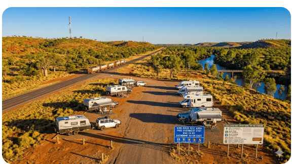
1. Why Grey Nomads Stop at King River Rest Area
When you are towing a caravan south from Darwin — or pushing north from Alice Springs — there comes a point on the Stuart Highway where fatigue, fuel planning and the setting sun all converge. For a remarkable number of grey nomads that convergence happens around the King River crossing, about 30 km south of Katherine.
Here is why it keeps appearing in campfire conversations and Facebook groups:
- Location: Right on the Stuart Highway, no detour needed — you simply pull off the sealed road into a clearly signed rest area on the western side of the highway.
- Cost: Completely free. No booking, no registration, no camp host collecting fees.
- Proximity to Katherine: Close enough to run into town for fuel, groceries and a medical clinic, yet far enough out to feel like bush camping.
- Space: The rest area can accommodate approximately 10–15 rigs depending on size, with a mix of pull-through and back-in bays on compacted gravel.
- Shade: Mature eucalyptus and paperbark trees provide partial shade — a genuine luxury in Territory heat.
- Scenery: The King River bridge offers views of a seasonal waterway that transforms from dry sandy bed to flowing river depending on the month.
For seniors in particular, the appeal is simple: you avoid paying $45–$60 for a powered site in Katherine when you only need a flat spot to sleep for one night before continuing your journey.
2. Free Camping — Looks Easy, But Know the Limits for Seniors
Free camping in the Northern Territory is governed by a combination of NT Government rest-area signage, local council by-laws and Parks & Wildlife regulations. King River Rest Area falls under NT Government road-corridor management, which means:
- Maximum stay: 24 hours (sometimes posted as “overnight rest only”). This is enforced in peak season (May–September) by occasional ranger or police patrols.
- Self-contained expectation: While not legally mandated at all NT rest areas, the strong community norm — and the practical reality — is that you need your own toilet and grey-water management. There is a pit toilet on site but no dump point at the rest area itself.
- No generators after 10 pm: A courtesy rule widely observed. If you run a generator for CPAP or medical equipment, consider a lithium battery alternative or park at the far end of the rest area away from other campers.
- No camping fees or permits required.
The 24-hour rule is the one that catches people out. Some grey nomads arrive mid-afternoon, enjoy the sunset, sleep well and then decide to stay a second night because the spot is so pleasant. Technically you are overstaying, and during busy dry-season weeks a ranger or passing police officer may ask you to move on. Practically, if the rest area is not full and you are tidy, enforcement is rare — but it is not guaranteed.
3. Your Two Main Options Side by Side
| Feature | King River Rest Area (Free) | Katherine Low Level Caravan Park (Paid) |
|---|---|---|
| Cost per night | Free | $42–$55 powered (2026 est.) |
| Power | None — BYO solar/battery | 240V at site |
| Water | None — BYO | Town water at site |
| Toilets | Pit toilet (basic) | Flush toilets & hot showers |
| Dump point | No — nearest ~30 km in Katherine | On site |
| Shade | Natural tree shade (partial) | Some shaded sites |
| Phone signal | Weak Telstra 4G — patchy | Telstra 4G/5G in Katherine |
| Pets | Yes — on lead | Yes — check park rules |
| Max stay | 24 hours | No limit (bookings) |
| Distance from Katherine CBD | ~30 km south | ~3 km from CBD |
4. Quick Facts and Key Details 2026
| Detail | Information |
|---|---|
| Official name | King River Rest Area |
| Location | Stuart Highway, approximately 30 km south of Katherine, NT |
| GPS Coordinates | -14.7300°, 132.2700° (approx — see Section 20 for full detail) |
| Postcode | 0852 |
| State / Territory | Northern Territory |
| Road | Stuart Highway (National Highway 1) |
| Road surface | Sealed highway; gravel pull-off into rest area |
| Overnight camping | Yes — free, 24-hour limit |
| Toilets | Pit toilet (check condition on arrival) |
| Water | No potable water — BYO |
| Dump point | No — nearest in Katherine (~30 km north) |
| Fires | Check seasonal fire bans; ground fires prohibited in total fire ban periods |
| Mobile signal | Weak Telstra 4G; Optus/Vodafone unlikely |
| Nearest fuel | Katherine (~30 km north) |
| Nearest hospital | Katherine Hospital (~32 km north) |
| Flooding risk | Yes — Wet season (Nov–Apr) the King River crossing and surrounding low-lying areas can flood; highway may close |
| Crocodile risk | Yes — freshwater crocodiles inhabit the King River; saltwater crocodiles possible in wet season |
| Suitable for big rigs | Yes — caravans, motorhomes, fifth-wheelers fit comfortably |
| Booking required | No |
| Cost | Free |
5. How to Get to King River Rest Area — Directions North & South
Driving from the North (Darwin → King River)
From Darwin CBD, head south on the Stuart Highway. The total distance is approximately 340 km (about 3.5–4 hours towing a caravan). Key waypoints:
- Darwin → Adelaide River (114 km) — fuel and food available at Adelaide River Inn.
- Adelaide River → Hayes Creek (25 km) — rest area and roadhouse.
- Hayes Creek → Pine Creek (90 km) — fuel, food, camping at Pine Creek.
- Pine Creek → Katherine (91 km) — full-service town with Woolworths, IGA, fuel stations, hospital.
- Katherine → King River Rest Area (~30 km south) — watch for the signed pull-off on the western (right) side of the highway as you head south, just after crossing the King River bridge.
Driving from the South (Alice Springs → King River)
From Alice Springs, the Stuart Highway distance north to King River Rest Area is approximately 1,185 km (12–14 hours towing). Most grey nomads break this into at least three days. Key waypoints heading north:
- Alice Springs → Ti Tree (194 km) — fuel, roadhouse.
- Ti Tree → Barrow Creek (90 km) — fuel (check opening hours).
- Barrow Creek → Wycliffe Well (approx 17 km) — fuel, camping.
- Wycliffe Well → Tennant Creek (approx 113 km from Barrow Creek) — full services.
- Tennant Creek → Renner Springs (161 km) — roadhouse fuel.
- Renner Springs → Dunmarra (114 km) — roadhouse fuel.
- Dunmarra → Daly Waters (approx 3 km off highway) — pub, fuel, camping.
- Daly Waters → Larrimah (approx 94 km north of Dunmarra) — fuel (limited hours).
- Larrimah → Mataranka (74 km) — fuel, hot springs, caravan parks.
- Mataranka → King River Rest Area (~100 km north) — the rest area is on the western (left) side if heading north, just before the King River bridge.
Road Conditions & Flooding
The Stuart Highway is fully sealed and well maintained in both directions. However:
The rest area entry is a short gravel/compacted-earth pull-off — typically in good condition during the dry season. After wet-season rains the surface may be soft, muddy or partially washed out. In June–September (peak grey nomad season) the surface is usually hard and easily navigable even by 2WD towing a large van.
Driving from the East (No Direct Route)
There is no direct east–west highway at this latitude that connects to King River. Travellers arriving from Queensland typically follow the Savannah Way (Highway 1) west through Borroloola or take the Roper Highway from Mataranka. Both routes involve significant unsealed sections. Most grey nomads will access King River via the Stuart Highway from either north or south.
Driving from the West
The Victoria Highway connects Katherine to Kununurra (WA) — approximately 512 km. From Katherine, King River is just 30 km south on the Stuart Highway. If you are arriving from WA via the Victoria Highway, fill up with fuel in Katherine before heading south to the rest area.
6. Heat, Crocodiles and Remoteness — What It Really Means for Seniors
Heat
Katherine and surrounds experience two seasons: the Dry (May–October) and the Wet (November–April). During the dry season — when most grey nomads visit — daytime temperatures still commonly reach 32–36 °C, with overnight lows around 14–20 °C. In the build-up and wet season, temperatures can hit 40 °C+ with extreme humidity.
For seniors, heat is a genuine medical risk. Dehydration, heat exhaustion and heat stroke can develop rapidly, especially if you are taking diuretics, beta-blockers or other medications that affect fluid balance or temperature regulation.
- Carry a minimum of 20 litres of drinking water per person in the vehicle at all times on the Stuart Highway.
- Set up camp in the shade wherever possible. Arrive before 2 pm to secure a shaded bay.
- Use reflective windscreen covers and side-window shades on your van.
- Drink water before you feel thirsty — aim for 2–3 litres per day minimum.
- Avoid setting up or packing down in the midday heat. Do these tasks early morning.
Crocodiles
The King River is crocodile habitat. Freshwater crocodiles (generally smaller and less aggressive) are present year-round. Saltwater (estuarine) crocodiles can move into the King River system during the wet season when water levels rise and floodplains connect coastal systems to inland waterways.
- Do not walk to the river’s edge, wade, swim or collect water from the King River.
- Do not clean fish or discard food scraps near the river or rest area.
- Keep children and pets well away from the waterline.
- Be especially cautious at dawn and dusk when crocodiles are most active.
- If you see a crocodile, report it to NT Parks & Wildlife: 1800 453 210.
Remoteness
While King River is only 30 km from Katherine — a town of around 6,300 people with a hospital — it is still classified as a remote location. Ambulance response times can be 30–60+ minutes depending on availability. If you have a serious medical condition, carry a current medication list, a first-aid kit and consider a personal locator beacon (PLB) or satellite communicator (e.g. Garmin inReach) as a backup to unreliable mobile coverage.
7. Wildlife at King River — Birds, Reptiles and What to Watch For
The King River corridor supports diverse wildlife, and for many grey nomads this is one of the highlights of stopping here:
Birds
- Red-tailed Black Cockatoos — frequently seen in late afternoon, flying between roosting and feeding trees.
- Sulphur-crested Cockatoos — common and loud, especially at dawn.
- Rainbow Bee-eaters — migratory visitors during the dry season, often perching on fence wires near the rest area.
- Blue-winged Kookaburras — distinctive laughing call, common in the Top End.
- Whistling Kites and Black Kites — often circling above the highway, attracted by roadkill.
- Jabiru (Black-necked Stork) — occasionally seen near the river during the wet and early dry season.
- Brolgas — may be spotted in open grasslands adjacent to the rest area.
Reptiles
- Freshwater crocodiles — in the river (see crocodile safety above).
- King Brown (Mulga) snakes — present in the region; keep footwear on when walking, especially at dusk and dawn.
- Western Brown snakes — also present; highly venomous.
- Blue-tongue lizards — commonly seen basking on warm ground.
- Frilled-neck lizards — iconic Territory reptile; sometimes spotted near trees.
Mammals & Insects
- Wallabies — Agile wallabies are common near the river and may graze near the rest area at dusk. Watch for them on the highway at night.
- Dingoes — occasionally sighted; do not feed them. Secure all food.
- Flying foxes (fruit bats) — large colonies roost in trees along the river and become active at dusk.
- Mosquitoes — can be fierce, especially in the early wet and after rain. Carry repellent with DEET (20%+) and long sleeves. Ross River virus and Murray Valley encephalitis are transmitted by mosquitoes in the NT.
- March flies (horse flies) — painful bite; most active in the build-up season.
8. What King River Rest Area Doesn’t Tell You Online
Most camping apps and websites list King River Rest Area as a basic free stop with a toilet. Here is what they usually leave out:
- Road noise: The rest area is directly beside the Stuart Highway. Road trains run 24/7 and the jake-brake roar at 2 am can be startling, especially for light sleepers. Pack earplugs or position your van with the bedroom end away from the road.
- Pit toilet condition: The toilet is not always serviced regularly. In peak season (July–August) it can be overwhelmed. Carry your own toilet paper and hand sanitiser — and be prepared to use your on-board toilet instead.
- Litter and previous campers: Unfortunately, not everyone leaves a rest area clean. You may find rubbish, abandoned fire pits or broken glass. A pair of thick gardening gloves and a rubbish bag lets you clear your chosen bay before setting up.
- No bins: There are no rubbish bins at King River Rest Area (or they may be removed/full). Take all rubbish with you.
- Water in the river: Even during the dry season, pools of water may remain in the King River. These attract crocodiles and mosquitoes. Do not assume a dry-looking river bed is safe.
- Popularity: In July and August, this rest area can fill by 3 pm. If you arrive late, you may need to continue north to Katherine or south to the next rest area.
- No shade guarantee: While trees are present, the shaded bays fill first. If you arrive after 2 pm you may be left in full sun.
9. Best Time to Visit King River — Month-by-Month Breakdown
| Month | Avg Max °C | Avg Min °C | Rain (mm) | Suitability for Seniors |
|---|---|---|---|---|
| January | 35 | 24 | 260 | ❌ Not recommended — wet, flooding, extreme heat & humidity |
| February | 34 | 24 | 270 | ❌ Not recommended — peak wet season |
| March | 34 | 23 | 210 | ❌ Not recommended — still wet, roads may close |
| April | 34 | 21 | 55 | ⚠️ Transitional — check road reports, hot & humid |
| May | 33 | 18 | 5 | ✅ Good — dry season begins, warm days, mild nights |
| June | 31 | 15 | 2 | ✅ Excellent — dry, comfortable, great for travel |
| July | 31 | 14 | 1 | ✅ Excellent — peak season, rest area may fill early |
| August | 33 | 16 | 1 | ✅ Excellent — dry, busy, arrive early |
| September | 36 | 20 | 5 | ⚠️ Good but warming — build-up begins late month |
| October | 37 | 23 | 35 | ⚠️ Hot & humid — storms begin |
| November | 37 | 24 | 100 | ❌ Not recommended — extreme heat, storms, flooding risk |
| December | 36 | 24 | 180 | ❌ Not recommended — full wet season |
The sweet spot for grey nomads is June, July and August. May and September are shoulder months that offer fewer crowds but increasing heat at the edges.
10. Free and Low-Cost Camping Near King River
If King River Rest Area is full — or if you want alternatives — here are nearby free and low-cost options:
| Camp | Distance from King River | Cost | Facilities |
|---|---|---|---|
| Katherine Low Level Caravan Park | ~33 km north | $42–$55/night powered | Power, water, showers, dump point, WiFi |
| Nitmiluk (Katherine Gorge) Campground | ~60 km north-east | $15.40/adult/night (Parks fee) | Toilets, showers, BBQ, no power |
| Edith Falls Campground (Leliyn) | ~90 km north | $15.40/adult/night (Parks fee) | Toilets, showers, swimming, no power |
| Mataranka area rest stops | ~100 km south | Free | Basic — pit toilet or none |
| Bitter Springs (Mataranka) | ~105 km south | $15.40/adult/night (Parks fee) | Toilets, swimming in thermal springs |
| Stuart Highway rest areas (various) | 20–50 km various | Free | Varies — some have toilets, some don’t |
11. Dump Points Near King River Rest Area
There is no dump point at King River Rest Area. The nearest options:
| Location | Distance from King River | Notes |
|---|---|---|
| Katherine Visitor Information Centre dump point | ~30 km north | Free public dump point; accessible 24 hours (confirm on arrival) |
| Katherine Low Level Caravan Park | ~33 km north | Available for guests; may allow non-guest use for a small fee |
| BP Katherine (Stuart Hwy) | ~30 km north | Some fuel stations offer dump-point access — ask staff |
| Mataranka Homestead | ~100 km south | For guests, or check for public access |
12. Free Water Sources Near King River
King River Rest Area has no potable water. Fill your tanks before arrival. The nearest free or low-cost water fill points:
| Location | Distance | Notes |
|---|---|---|
| Katherine Visitor Information Centre | ~30 km north | Free water tap — confirm availability on arrival |
| Katherine service stations | ~30 km north | Ask permission; some offer free water fill with fuel purchase |
| Katherine Low Level Caravan Park | ~33 km north | For guests; non-guests may ask (small fee possible) |
| Mataranka town bore water | ~100 km south | Bore water — may have mineral taste |
13. Fuel Stops Along the Stuart Highway near King River
Fuel planning is critical on the Stuart Highway. The distances between fuel stops can be significant, and prices increase the further you are from major towns. Here is a practical fuel-stop guide in each direction from King River Rest Area:
Heading North (King River → Darwin)
| Fuel Stop | Approx Distance from King River | Notes |
|---|---|---|
| Katherine (multiple stations) | 30 km | BP, Coles Express, independent — best prices in the region |
| Pine Creek | 120 km | Fuel, food, limited hours (check before relying) |
| Hayes Creek Roadhouse | 205 km | Fuel, meals — junction for Litchfield turnoff |
| Adelaide River | 225 km | Fuel, Adelaide River Inn |
| Darwin | 340 km | Full services |
Heading South (King River → Alice Springs)
| Fuel Stop | Approx Distance from King River | Notes |
|---|---|---|
| Mataranka | 100 km | Fuel, pub, caravan parks, hot springs nearby |
| Larrimah | 175 km | Fuel (check opening hours — limited) |
| Daly Waters | 195 km | Fuel, iconic pub, camping |
| Dunmarra | 200 km | Roadhouse fuel |
| Elliott | 330 km | Fuel, basic supplies |
| Renner Springs | 355 km | Roadhouse fuel |
| Tennant Creek | 520 km | Full services — supermarket, hospital |
Heading West (via Katherine → Kununurra)
| Fuel Stop | Approx Distance from King River | Notes |
|---|---|---|
| Katherine | 30 km | Fill up here before heading west |
| Victoria River Roadhouse | ~230 km (via Katherine) | Fuel, accommodation, camping |
| Timber Creek | ~320 km (via Katherine) | Fuel, camping, police station |
| Kununurra (WA) | ~540 km (via Katherine) | Full services |
14. Katherine Low Level Caravan Park — The Paid Alternative
If you need powered sites, hot showers, a dump point and the security of being in town with medical facilities nearby, Katherine Low Level Caravan Park is the most popular paid option. It sits on the banks of the Katherine River approximately 3 km from the Katherine CBD and about 33 km north of King River Rest Area.
Key details (2026 estimates):
- Powered sites: $42–$55 per night (rates vary by season and site type)
- Unpowered sites: $30–$38 per night
- Facilities: Power, town water, hot showers, flush toilets, laundry, camp kitchen, dump point, BBQ areas
- WiFi: Available (may be limited/paid)
- Pets: Allowed in some areas — confirm when booking
- Bookings: Recommended in peak season (June–August)
- Flooding note: The Low Level Caravan Park can be affected by Katherine River flooding — it closed during major floods in 1998 and 2006. In the dry season (when most grey nomads visit) this is not a concern.
Other paid options in Katherine include Katherine Top Springs, Knotts Crossing Resort and Big 4 Katherine — all offering full caravan park facilities at varying price points.
15. Full Facilities Comparison Table
| Facility | King River Rest Area | Katherine Low Level CP | Nitmiluk Campground | Edith Falls Campground |
|---|---|---|---|---|
| Power | ❌ | ✅ | ❌ | ❌ |
| Potable water | ❌ | ✅ | ✅ | ✅ |
| Flush toilets | ❌ (pit) | ✅ | ✅ | ✅ |
| Hot showers | ❌ | ✅ | ✅ | ✅ |
| Dump point | ❌ | ✅ | ❌ | ❌ |
| Camp kitchen | ❌ | ✅ | ✅ | ✅ |
| Shade | Partial (natural) | Some sites | Good | Excellent |
| Swimming | ❌ (crocs) | ❌ (crocs in river) | ❌ (crocs) | ✅ (croc-monitored) |
| Cost | Free | $$ | $ | $ |
16. Rates — All Options Near King River 2026
| Option | Cost per Night (2 adults, 2026 est.) | Notes |
|---|---|---|
| King River Rest Area | $0 | Free — 24-hour limit |
| Katherine Low Level Caravan Park (powered) | $42–$55 | Full facilities |
| Nitmiluk (Katherine Gorge) Campground | $30.80 (2 × $15.40) | Parks fee; no power |
| Edith Falls (Leliyn) Campground | $30.80 (2 × $15.40) | Parks fee; swimming; no power |
| Big 4 Katherine (powered) | $50–$65 | Full resort-style facilities |
All rates are estimates for 2026 based on publicly available information. Confirm directly with each provider before arrival.
17. The King River Day Plan for Seniors
Here is a suggested schedule for a one-night transit stop at King River Rest Area, designed around senior comfort and safety:
| Time | Activity |
|---|---|
| 1:00 pm – 2:00 pm | Arrive at King River Rest Area. Walk the site and choose a shaded bay. Level the van, set up awning and chairs. |
| 2:00 pm – 3:30 pm | Rest during the heat of the day. Read, nap, or sit under the awning with a cold drink. |
| 3:30 pm – 4:30 pm | Short walk around the rest area (stay on paths, wear closed shoes). Watch for birds in the trees. |
| 4:30 pm – 5:30 pm | Prepare dinner. Gas stove or camp oven — no ground fires unless permitted (check sign at rest area). |
| 5:30 pm – 6:30 pm | Sunset viewing. In winter the sky can turn spectacular shades of orange and pink over the savannah woodland. |
| 6:30 pm – 8:00 pm | Chat with fellow travellers. Grey nomad rest areas are social — swap stories and route tips. |
| 8:00 pm – 9:00 pm | Star gazing (minimal light pollution). Apply mosquito repellent before heading outside. |
| 9:00 pm | Retire to the van. Earplugs in. Road trains run all night. |
| 6:00 am – 6:30 am | Wake with first light. Make tea/coffee. Enjoy the cool of the morning. |
| 6:30 am – 7:30 am | Pack up while it is still cool. Hitch the van. Check tyre pressures. |
| 7:30 am | Depart. Head north to Katherine for fuel, water and dump point — or continue south. |
18. Senior Checklist — King River and Stuart Highway
📥 Printable Senior Checklist — King River Rest Area & Stuart Highway
Print this list and stick it on your van fridge or keep it in the glovebox. Tick each item before you leave Katherine heading south (or before arriving from the south).
- ☐ Fuel tank full (minimum ¾ tank + 20L jerry can)
- ☐ Fresh water tank full (minimum 20L per person drinking water separately stored)
- ☐ Cassette toilet emptied or has capacity for 24+ hours
- ☐ Grey water tank emptied or capacity checked
- ☐ CPAP battery or 12V adapter packed and charged
- ☐ Medications — minimum 7-day supply accessible
- ☐ Current medication list (laminated copy in glovebox)
- ☐ First-aid kit checked and stocked
- ☐ Insect repellent (DEET-based) accessible
- ☐ Sunscreen SPF 50+ accessible
- ☐ Wide-brim hat and long-sleeve shirt out
- ☐ Closed shoes for walking (snake protection)
- ☐ Torch / headlamp with fresh batteries
- ☐ Earplugs (for road-train noise)
- ☐ Tyre pressure checked (including spare and caravan tyres)
- ☐ UHF radio on and monitoring Channel 40
- ☐ Mobile phone charged — Telstra SIM for best coverage
- ☐ NT road report checked — roadreport.nt.gov.au
- ☐ Emergency contacts saved in phone and written on paper
- ☐ PLB or satellite communicator packed (recommended)
- ☐ Reflective windscreen and window shades for van
- ☐ Camp chairs and small table for outside sitting
- ☐ Rubbish bags (no bins at rest area)
- ☐ Toilet paper and hand sanitiser (rest area toilet may be out of paper)
19. What to Do Near King River — Senior Activity Guide
King River Rest Area is a transit stop, but the surrounding Katherine region offers outstanding activities for seniors. Here are the best options within a reasonable day trip:
Nitmiluk (Katherine Gorge) — 60 km north-east
Arguably the #1 attraction in the Katherine region. Options for seniors include:
- Flat-water cruise: 2-hour or 4-hour boat cruises through the gorge system. Minimal walking required — boats depart from a jetty with good path access. Book ahead in peak season.
- Visitor centre: Air-conditioned with displays on geology and Aboriginal cultural history.
- Short walks: The Baruwei Loop (interpretive walk, 1.5 km, mostly flat) suits seniors with moderate mobility.
Edith Falls (Leliyn) — 90 km north
Beautiful plunge pool at the base of a waterfall — croc-monitored and generally safe for swimming during the dry season (always check signage). The walk to the upper pool is steep and not recommended for seniors with joint or mobility issues; the lower pool is a flat 200-metre walk from the car park.
Katherine Hot Springs — 33 km north
Thermal springs right in Katherine town. Free entry, gentle warm water (30–32 °C), shaded grassy banks. Very senior-friendly. Access via steps into the water — handrail available at the main entry point.
Cutta Cutta Caves — 27 km south of Katherine (~3 km north of King River)
Limestone cave system with guided tours. The caves maintain a cool temperature year-round — a pleasant break from the heat. Tours involve stairs and uneven surfaces; moderate mobility required. Check for seasonal closures during the wet season.
Katherine Museum — 33 km north
Small local museum in the old railway station building. Displays on the town’s history, the 1998 flood and railway heritage. Gold coin donation. Air-conditioned. Very senior-friendly.
Mataranka Thermal Pool & Bitter Springs — 100 km south
If you are heading south, the Mataranka thermal pool (in Elsey National Park) and nearby Bitter Springs offer crystal-clear warm swimming in natural bush settings. Both are croc-monitored in the dry season. Bitter Springs has a gentle lazy-river float that is particularly enjoyed by older travellers.
20. GPS Coordinates and Postcodes — Save Every Stop
Save these into your GPS, phone maps or Hema HX-2 before you lose signal:
| Location | Latitude | Longitude | Postcode | Source |
|---|---|---|---|---|
| King River Rest Area | -14.7300 | 132.2700 | 0852 | WikiCamps / public mapping |
| Katherine Visitor Info Centre | -14.4524 | 132.2710 | 0850 | Google Maps |
| Katherine Low Level Caravan Park | -14.4710 | 132.2680 | 0850 | Google Maps |
| Nitmiluk (Katherine Gorge) Campground | -14.3166 | 132.4182 | 0852 | NT Parks |
| Edith Falls (Leliyn) Campground | -14.1798 | 132.2020 | 0852 | NT Parks |
| Cutta Cutta Caves | -14.5660 | 132.2610 | 0852 | NT Parks |
| Katherine Hot Springs | -14.4600 | 132.2620 | 0850 | Google Maps |
| Mataranka Thermal Pool | -14.9220 | 133.0720 | 0852 | NT Parks |
| Bitter Springs (Mataranka) | -14.9200 | 133.1000 | 0852 | NT Parks |
Nearby Public WiFi
There is no public WiFi at King River Rest Area. The nearest free WiFi access points:
- Katherine Public Library — free WiFi during opening hours (Katherine Terrace, Katherine 0850).
- Katherine Visitor Information Centre — may offer WiFi for visitors.
- McDonald’s Katherine — free WiFi with purchase.
21. People Also Ask — King River Rest Area
Can you camp overnight at King River Rest Area?
Yes. King River Rest Area permits free overnight camping for up to 24 hours. No booking or permit is required. It is a roadside rest area managed by the NT Government, not a national park campground.
Is King River Rest Area safe for seniors?
It is generally safe for one-night transit stops during the dry season (May–September). The main risks are heat, crocodiles near the river, snakes and remoteness from medical facilities. Take sensible precautions: stay hydrated, wear closed shoes, do not approach the river and carry a first-aid kit.
Does King River Rest Area have toilets?
Yes — a pit toilet (long drop) is provided. Condition varies. Carry your own toilet paper and hand sanitiser. Having an on-board toilet as backup is strongly recommended.
Are there crocodiles at King River?
Yes. Freshwater crocodiles inhabit the King River year-round. Saltwater crocodiles may also be present, particularly during the wet season. Do not swim, wade or walk to the water’s edge.
Is the road to King River Rest Area sealed?
The Stuart Highway is fully sealed. The pull-off into the rest area is compacted gravel — suitable for all vehicles including caravans and motorhomes in the dry season.
Does the road flood near King River?
Yes. The King River crossing can flood during the wet season (November–April), potentially closing the Stuart Highway for hours or days. Always check roadreport.nt.gov.au before travelling in the wet season.
22. Frequently Asked Questions
Q: How long can I stay at King River Rest Area?
A: The official limit is 24 hours (one overnight stay). This is typical for NT Government roadside rest areas.
Q: Is there a dump point at King River Rest Area?
A: No. The nearest dump point is in Katherine, approximately 30 km north.
Q: Can I get mobile phone signal at King River?
A: Telstra 4G may be available but signal is weak and patchy. Optus and Vodafone coverage is unlikely. For reliable communication, carry a satellite device (PLB or satellite communicator).
Q: Is there drinking water at King River Rest Area?
A: No. There is no potable water available. Fill your tanks in Katherine before arriving.
Q: Can I bring my dog to King River Rest Area?
A: Yes. Pets are allowed at the rest area but must be kept on a lead and under control at all times. Be aware of crocodile risk near the river and snake risk in grassland areas.
Q: Is King River Rest Area suitable for big caravans?
A: Yes. The rest area can accommodate large caravans, fifth-wheelers and motorhomes. Entry and exit are directly off the Stuart Highway with adequate turning room.
Q: Where is the nearest hospital to King River Rest Area?
A: Katherine Hospital, approximately 32 km north. In a medical emergency, call 000.
Q: Can I have a campfire at King River Rest Area?
A: Check the signage on arrival. During the dry season, fire bans may be in effect across the NT. See Section 26 for full detail on campfire rules.
23. Quick-Reference Card
📋 King River Rest Area — Quick-Reference Card
| Name: | King River Rest Area |
| GPS: | -14.7300, 132.2700 |
| Road: | Stuart Highway (sealed) |
| Cost: | Free |
| Max stay: | 24 hours |
| Toilet: | Pit toilet (BYO paper) |
| Water: | None — BYO |
| Dump point: | No — Katherine 30 km |
| Fuel: | Katherine 30 km north |
| Hospital: | Katherine Hospital 32 km |
| Phone: | Telstra 4G (weak) |
| Crocs: | YES — do not approach river |
| Floods: | Wet season risk — check road report |
| Emergency: | 000 (if signal) or PLB |
24. Permits and Park Fees
King River Rest Area does not require any permit or fee. It is a public roadside rest area maintained by the Northern Territory Government under its road-corridor management program.
However, if you plan to visit nearby national parks during your time in the Katherine region, you will need to be aware of NT Parks fees:
- Nitmiluk National Park: Park entry is free, but camping fees apply (approximately $15.40/adult/night in 2026).
- Elsey National Park (Mataranka): Camping fees apply.
- Kakadu National Park (further north): Park pass required ($40/adult for 7 days in recent years — check parksaustralia.gov.au for 2026 pricing).
- NT Parks Pass: A Territory-wide pass may save money if visiting multiple parks. Check nt.gov.au/parks.
No Aboriginal land permits are required for travel along the Stuart Highway or for stopping at King River Rest Area.
25. Phone Signal and Emergency Communications
Mobile coverage at King River Rest Area is limited:
| Provider | Signal at King River | Notes |
|---|---|---|
| Telstra | Weak 4G — 1–2 bars | Best coverage of any provider in NT; an external antenna can improve signal |
| Optus | Unlikely / No signal | Optus coverage on the Stuart Highway is limited outside major towns |
| Vodafone / TPG | No signal | Minimal NT coverage outside Darwin |
- PLB (Personal Locator Beacon): Register with AMSA and carry one whenever travelling remote. Activation sends your GPS position to rescue services via satellite — no phone signal needed.
- Satellite communicator (e.g. Garmin inReach Mini 2): Allows two-way text messaging via satellite. Monthly plans start from ~$20/month. Can send an SOS and communicate with rescue services even with zero mobile coverage.
- UHF Radio: Monitor Channel 40 (road channel) while driving. Useful for hearing road-train warnings and communicating with other travellers in convoy.
- External antenna: A Cel-Fi GO or similar mobile-signal booster with an external antenna on your caravan roof can dramatically improve weak Telstra signal. Legal to use in Australia.
26. Campfires and Cooking at King River
Fire management in the Northern Territory follows a seasonal pattern:
- Early dry season (May–June): Fires may be permitted in designated fire pits where provided. Always check the sign at the rest area.
- Late dry season (July–October): Fire bans are increasingly common as vegetation dries. Total fire bans can be declared with short notice.
- Wet season (November–April): Fires are generally permitted but the rest area may be inaccessible due to flooding.
King River Rest Area may or may not have a designated fire pit. If no fire ring or pit is visible, do not light a ground fire. Use your gas stove, camp oven on a gas ring, or Weber-style portable BBQ instead.
- Check the NT fire-ban status at securent.nt.gov.au/alerts or listen to ABC Radio (local frequencies).
- If in doubt, do not light a fire.
- Always have water or a fire extinguisher within reach.
- Extinguish completely before sleeping — “cold to touch” is the standard.
- Do not burn rubbish in a campfire. Take it with you.
27. Pets at King River Rest Area
Pets — primarily dogs — are allowed at King River Rest Area. It is not a national park, so national park pet restrictions do not apply.
However, travelling with a pet in the Territory requires extra precautions:
- Crocodile risk: Never let your dog near the King River or any waterway. Crocodiles will take dogs. Keep your pet on a lead at all times and within sight.
- Cane toads: Cane toads are prevalent in the Katherine region. If a dog mouths or licks a cane toad, the toxin can be fatal. Supervise your dog closely at dawn and dusk when toads are most active. If poisoning occurs: wipe the gums with a wet cloth, do not flush water into the mouth, and get to a vet in Katherine immediately.
- Heat: Dogs are highly susceptible to heat stroke. Ensure shade, constant water access and never leave a pet in a vehicle. Walk dogs only in the cool of early morning or evening.
- Snakes: King Brown and Western Brown snakes can be encountered. A curious dog is at high risk of being bitten. Keep dogs leashed and on cleared paths.
- Ticks: Paralysis ticks can occur in the NT. Check your dog daily, particularly behind ears, between toes and around the neck.
28. Accessibility for Seniors with Mobility Limitations
King River Rest Area is a basic roadside stop and has not been designed with accessibility standards in mind. Here is an honest assessment:
| Feature | Accessibility Rating | Notes |
|---|---|---|
| Vehicle access | Good | Drive directly into rest area from highway; flat parking bays |
| Ground surface | Fair | Compacted gravel — may be uneven. Not suitable for standard wheelchairs. A heavy-duty outdoor wheelchair or rollator with large wheels may cope. |
| Toilet | Poor | Pit toilet — unlikely to have grab rails, wheelchair access or a sealed floor. Use on-board toilet if mobility is limited. |
| Pathways | None | No formed paths. Walk on natural ground. Trip hazards from tree roots and uneven gravel. |
| Shade seating | BYO | There may be a picnic table but condition varies. Bring your own chairs. |
Recommendation for seniors with limited mobility: Use King River Rest Area for vehicle-based overnight stops (sleep in your van/motorhome, use your on-board facilities). If you need accessible toilets, showers with grab rails and level pathways, stay at a caravan park in Katherine where facilities are purpose-built.
29. Reviews — What Real Grey Nomads Say About King River Rest Area
Based on publicly available reviews from WikiCamps, camping forums and grey nomad Facebook groups, here are the common themes:
- “Great free stop — saved us a night’s campsite fees. Arrived at 2 pm, had the place almost to ourselves.”
- “Good shade under the big gum trees. Parked the van in dappled shade and it was 10 degrees cooler than full sun.”
- “Lovely sunset over the bush. Sat out with a cuppa and watched the cockatoos come in to roost.”
- “Clean toilet when we visited (July 2025). Well maintained.”
- “Easy pull-off from the highway even with a 22-footer. Flat, level, no hassles.”
- “Road trains through the night — very noisy. Bring earplugs!”
- “Toilet was in poor condition when we visited (August 2025). Out of paper and not cleaned. Used our own toilet.”
- “Got there at 4 pm on a Saturday in July — almost full. Had to squeeze into the last spot.”
- “Mozzies were terrible after a late-season rain. Should have used more repellent.”
- “Saw a croc slide into the water from the bridge — reminder not to go near the river!”
Note: Reviews are paraphrased summaries of common themes, not direct quotes from identified individuals.
30. Related Free Camping Guides on the Stuart Highway
If you are travelling the Stuart Highway as part of a longer grey nomad trip, these guides cover other popular free and low-cost stops along the route:
- Ellendale Rest Area Free Camping Guide — another popular free rest stop along the Stuart Highway corridor
- Pine Creek Free Camping & Rest Areas — gold-rush town with free camping and fuel
- Mataranka & Elsey National Park Camping Guide — thermal springs, affordable camping, iconic Territory experience
- Daly Waters to Tennant Creek Free Rest Stops — the long southern stretch with critical fuel planning
- Adelaide River to Hayes Creek Rest Areas — convenient stops between Darwin and Katherine
(Links to be added as guides are published on the website.)
31. Disclaimer
Always:
- Check current NT road conditions at roadreport.nt.gov.au or call 1800 246 199 before travelling.
- Verify campground fees and availability directly with the relevant authority.
- Obey all signage at the rest area.
- Carry adequate water, fuel, food and medication for your journey.
- Consult your GP before undertaking remote travel if you have a chronic medical condition.
- Register your travel plans with a friend or family member.
— End of Guide —
King River Rest Area Free Camping Senior Grey Nomad Guide 2026
Written for travellers 55+ · No paywall · No app required