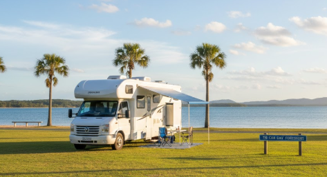
There are very few places in Queensland where you can watch wild dolphins glide into shore each morning from your camp chair — Tin Can Bay is one of them. Your practical, retiree‑friendly guide to free camps, water points, dump points, fuel stops, Wi‑Fi, medical access, disability access and safety around Tin Can Bay. Whether you’re a grey nomad, caravanner or vanlifer, this guide gives you accurate GPS coordinates, access notes, amenities and local insights to help you travel confidently and comfortably.
Free Camping Near Tin Can Bay (Best Retiree‑Friendly Spots)
Tin Can Bay sits at the end of a quiet peninsula on the Cooloola Coast, about 65 km south-east of Gympie via the Tin Can Bay Road. It’s a genuine coastal fishing village — calm, unhurried, and surprisingly well-set-up for RV friendly Tin Can Bay travellers. The sheltered inlet, flat terrain and low traffic make it one of the most relaxed free camping destinations in south-east Queensland. One grey nomad who’d been returning every winter for six years said it simply: the dolphins come in every morning, the fish are biting by lunchtime, and by sunset you’ve already forgotten what week it is.
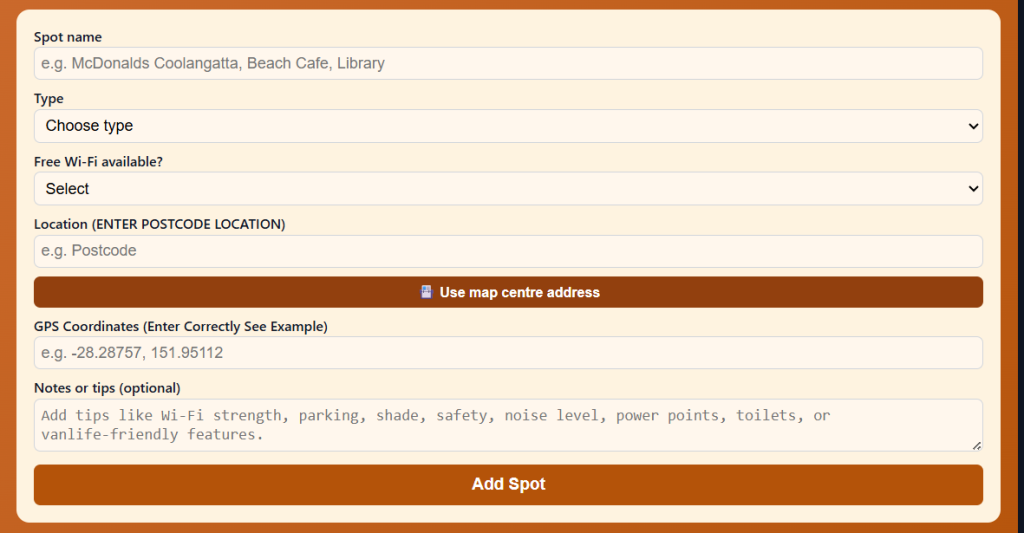
Use the Vanlife Savings Spots App to save your locations. Add your postcode, GPS coordinates and notes, then tap “Add Spot” to place it on the map and get directions.
Ross Creek Store Rest Area – Goomboorian QLD 4570
Distance from Tin Can Bay: Approx. 34 km west on Tin Can Bay Road (18 km east of Gympie) Maximum Stay: Overnight (donation-based — please support the store) Self‑Contained Required: No — toilets on site Toilets On‑Site: Yes — clean facilities on site Toilet Address: 1460 Tin Can Bay Road, Goomboorian QLD 4570 Toilet GPS: -26.0906, 152.7672 (approx.) Showers: No Pet‑Friendly: Yes Caravan‑Friendly / Big‑Rig Access: Suitable for small to medium caravans and campervans; the paddock entry is not wide — inspect the entrance carefully before entering and use the turnaround space before committing; big rigs should assess carefully Campervan Access: Yes Camper Trailer Access: Yes Tent Camping Allowed: Yes Vehicle Restrictions: Paddock width is limited — large combinations should use extreme caution; do not attempt in the dark without first inspecting in daylight Telstra Reception: Yes — good reception reported GPS: -26.0906, 152.7672 (Public mapping data) Address: 1460 Tin Can Bay Road, Goomboorian QLD 4570 Coordinate Source: Public mapping data
Note: This is a private store offering free camping as a community service. Please support the business — buy a pie, grab fuel, or purchase supplies. There is a donation box on site.
Accessibility (Disability‑Friendly Notes)
- Wheelchair-accessible toilets: Not confirmed — enquire at store on arrival
- Accessible parking: Yes — flat grassed area; sealed store forecourt nearby
- Pathway surface: Grassed paddock; store forecourt sealed; generally flat
- Mobility-friendly access to amenities: Moderate — compact site; short distances
- Turning space for mobility devices: Good in the flat paddock area
- Suitability for travellers with limited mobility: Moderate — flat, but unpaved in camp area
- Nearby accessible toilets: Within site; Tin Can Bay town centre approx. 34 km east
- Emergency toilet options within 1–5 km: On-site
Access Notes
- Road type: Direct entry off the southern side of Tin Can Bay Road; easy turn-in for standard rigs
- Turning space: There is a turnaround space before the paddock — inspect the paddock width before driving in
- Caravan/motorhome suitability: Small to medium caravans and campervans; large rigs need to assess on arrival
- Vehicle limitations: Paddock is not wide; parking arrangement can make manoeuvring tight if busy
Why Retirees Like It
This is one of the most warmly reviewed stop-overs on the entire Tin Can Bay Road corridor. The Ross Creek Store is a genuine family-run country store with home-made pies (the lamb shank and chicken camembert pies are famous — travellers plan their timing around stopping for one), crab sandwiches, hot chips and cold drinks. The camp area has undercover tables and chairs, a sink for washing dishes, a children’s playground, and toilets — making it far better appointed than most free camps. Fuel is available at the store. It’s a genuinely welcoming, community-minded stop that makes low-cost camping Tin Can Bay travellers feel like they’re being looked after.
Nearby Public Wi‑Fi Options
Gympie McDonald’s – Gympie QLD 4570 Address: 8 Lake Alford Dr, Gympie QLD 4570 Free Wi‑Fi: Yes Toilets: Yes — accessible Toilet Address: 8 Lake Alford Dr, Gympie QLD 4570 Toilet GPS: -26.1942, 152.6711 Parking suitability: Large carpark — suitable for caravans and motorhomes Wi‑Fi GPS: -26.1942, 152.6711 Parking GPS: -26.1942, 152.6711
Driving Directions
➡ From Tin Can Bay, head west on Tin Can Bay Road approx. 34 km ➡ OR from Gympie, head east on Tin Can Bay Road approx. 18 km ➡ Ross Creek Store is on the southern (left-hand) side of the road — large sign visible from road ➡ Easy turn-in — inspect paddock width before driving in
Tips
- Arrival time: Arrive before 5 pm to ensure the store is open for supplies
- Store hours: Generally 5 am–7 pm daily — check current hours on arrival
- Noise: Some traffic noise from Tin Can Bay Road — not excessive
- Wet season notes: Paddock can be soft after heavy rain; park on firmer ground near entry
- Safety: Friendly, well-established community stop; very safe overnight
Tin Can Bay Foreshore Rest Area – Tin Can Bay QLD 4580
Distance from Tin Can Bay: 0 km — within the township, on the foreshore Maximum Stay: Overnight parking — verify current council rules on arrival; some sections are day-stop only Self‑Contained Required: Check current signage — some overnight areas require self-containment Toilets On‑Site: Yes — public toilet block on the foreshore Toilet Address: Norman Point Drive, Tin Can Bay QLD 4580 Toilet GPS: -25.9178, 153.0001 (approx.) Showers: No — nearest showers at caravan parks in town Pet‑Friendly: Yes — on lead Caravan‑Friendly / Big‑Rig Access: Yes — wide foreshore road with generous turning area Campervan Access: Yes Camper Trailer Access: Yes Tent Camping Allowed: Not in foreshore parking areas — check current rules Vehicle Restrictions: None noted on main foreshore road Telstra Reception: Yes — good reception in town GPS: -25.9178, 153.0001 (Public mapping data) Address: Norman Point Drive, Tin Can Bay QLD 4580 Coordinate Source: Public mapping data
Note: Tin Can Bay foreshore overnight camping rules have been subject to ongoing council review. Always verify current rules on arrival and follow any posted signage. Some foreshore sections are day-only. The Gympie Regional Council’s formal RV park site at the corner of Gympie Road and Coral Trout Drive may also be available by the time you visit — check current status with council on 1300 307 800.
Accessibility (Disability‑Friendly Notes)
- Wheelchair-accessible toilets: Yes — foreshore toilet block has accessible facilities
- Accessible parking: Yes — sealed flat foreshore road
- Pathway surface: Sealed foreshore path — excellent for mobility devices
- Mobility-friendly access to amenities: Excellent — flat, sealed, level foreshore throughout
- Turning space for mobility devices: Generous — open foreshore area
- Suitability for travellers with limited mobility: Excellent — one of the most accessible foreshore areas on the Cooloola Coast
- Nearby accessible toilets: On-site foreshore block; Tin Can Bay CBD (500 m)
- Emergency toilet options within 1–5 km: Multiple locations in Tin Can Bay township
Access Notes
- Road type: Sealed foreshore road; flat and wide
- Turning space: Excellent — wide foreshore turning area
- Caravan/motorhome suitability: Excellent for standard rigs; big rigs should use the western end with more space
- Vehicle limitations: None for standard configurations
Why Retirees Like It
Waking up on the Tin Can Bay foreshore is one of those simple pleasures that makes long-distance travel completely worthwhile. The inlet is calm and sheltered — no surf, no noise, just the gentle lapping of tide and the sound of pelicans settling on the water. Norman Point is home to Barnacles Dolphin Centre, where wild Indo-Pacific humpback dolphins come in each morning — you could be feeding them before you’ve finished your first cup of tea. The foreshore walk is flat, sealed and completely accessible. The town is 500 metres away with shops, cafés, a bakery and a pharmacy. Overnight parking Tin Can Bay style doesn’t get much better than this.
Nearby Public Wi‑Fi Options
Tin Can Bay Library – Tin Can Bay QLD 4580 Address: 9-11 Tin Can Bay Rd, Tin Can Bay QLD 4580 Free Wi‑Fi: Yes Toilets: Yes — accessible Toilet Address: 9-11 Tin Can Bay Rd, Tin Can Bay QLD 4580 Toilet GPS: -25.9178, 153.0001 (approx.) Parking suitability: Good — street parking; suitable for campervans Wi‑Fi GPS: -25.9178, 153.0001 Parking GPS: -25.9178, 153.0001
Driving Directions
➡ From Gympie, head east on Tin Can Bay Road approx. 52 km ➡ At the roundabout, bear right onto Tin Can Bay Rd (main street) ➡ Continue to the foreshore — Norman Point Drive runs along the waterfront ➡ Barnacles Dolphin Centre is at the northern end of the foreshore near the boat ramp
Tips
- Arrival time: Afternoon — morning can be busy near Barnacles during dolphin feeding
- Dolphin feeding: Dolphins typically arrive 7–7:30 am; feeding commences around 8 am — unauthorised feeding is prohibited
- Noise: Very quiet — sheltered inlet; virtually no traffic noise on the waterfront at night
- Wet season notes: Foreshore can be breezy in wet season storms — secure your awning
- Safety: Safe, quiet coastal town; well-lit foreshore at night
Cooloola Cove Rest Area – Cooloola Cove QLD 4580
Distance from Tin Can Bay: Approx. 5 km north via the Cooloola Coast Road Maximum Stay: As per current signage — verify on arrival Self‑Contained Required: Check current requirements Toilets On‑Site: Yes — public toilet block Toilet Address: Cooloola Cove Boulevard, Cooloola Cove QLD 4580 Toilet GPS: -25.8900, 153.0100 (approx.) Showers: No Pet‑Friendly: Yes — on lead Caravan‑Friendly / Big‑Rig Access: Yes — flat residential and foreshore access road Campervan Access: Yes Camper Trailer Access: Yes Tent Camping Allowed: Check current rules Vehicle Restrictions: Residential road — drive slowly and courteously Telstra Reception: Yes GPS: -25.8900, 153.0100 (Public mapping data) Address: Cooloola Cove Boulevard, Cooloola Cove QLD 4580 Coordinate Source: Public mapping data
Accessibility (Disability‑Friendly Notes)
- Wheelchair-accessible toilets: Yes — council-maintained facility
- Accessible parking: Yes — flat sealed area
- Pathway surface: Mostly sealed and flat; foreshore grass in places
- Mobility-friendly access to amenities: Good
- Turning space for mobility devices: Good
- Suitability for travellers with limited mobility: Good
- Nearby accessible toilets: Within site; Tin Can Bay CBD approx. 5 km south
- Emergency toilet options within 1–5 km: On-site; Cooloola Cove township
Access Notes
- Road type: Sealed residential road through Cooloola Cove township
- Turning space: Good at the foreshore end
- Caravan/motorhome suitability: Good — be mindful of residential streets; drive slowly
- Vehicle limitations: Not suitable for very long combinations on narrow streets
Why Retirees Like It
Cooloola Cove is a quiet, residential waterfront suburb just north of Tin Can Bay — calmer and less touristy than the main township. The foreshore here is peaceful in the extreme, with views across the Great Sandy Strait and excellent birdwatching from the water’s edge. It’s a lovely alternative overnight stop for self-contained camping Tin Can Bay travellers who prefer a quieter spot with fewer people. The Cooloola Cove General Practice (Cooloola Coast General Practice) is also located here — useful for retirees needing medical access without the 45 km drive to Gympie.
Nearby Public Wi‑Fi Options
Cooloola Cove Community Centre – Cooloola Cove QLD 4580 Address: Cooloola Cove Blvd, Cooloola Cove QLD 4580 Free Wi‑Fi: Enquire at community centre Toilets: Yes Toilet Address: Cooloola Cove Blvd, Cooloola Cove QLD 4580 Toilet GPS: -25.8900, 153.0100 (approx.) Parking suitability: Good — flat open area Wi‑Fi GPS: -25.8900, 153.0100 Parking GPS: -25.8900, 153.0100
Driving Directions
➡ From Tin Can Bay, head north on the Cooloola Coast Road (Gympie-Cooloola Rd) ➡ Approx. 5 km — turn right into Cooloola Cove Boulevard ➡ Follow to the foreshore — rest area and toilets visible on arrival
Tips
- Arrival time: Any time — quieter than the main Tin Can Bay foreshore
- Noise: Very quiet — residential suburb with very little traffic overnight
- Safety: Quiet, safe residential area
Rainbow Beach Foreshore Parking – Rainbow Beach QLD 4251
Distance from Tin Can Bay: Approx. 32 km south-east via Tin Can Bay Road and Rainbow Beach Road Maximum Stay: As per current signage — verify on arrival; some areas allow overnight; others are day-only Self‑Contained Required: Check current Rainbow Beach signage Toilets On‑Site: Yes — foreshore toilet block Toilet Address: Spectrum St, Rainbow Beach QLD 4251 Toilet GPS: -25.9033, 153.0959 (approx.) Showers: Cold showers available at surf lifesaving club/foreshore (verify availability) Pet‑Friendly: Yes — on lead; not on main beach Caravan‑Friendly / Big‑Rig Access: Yes — wide foreshore road Campervan Access: Yes Camper Trailer Access: Yes Tent Camping Allowed: Not on foreshore — national park areas require permits Vehicle Restrictions: No 4WD beach driving on Rainbow Beach main foreshore without permit Telstra Reception: Yes GPS: -25.9033, 153.0959 (Public mapping data) Address: Spectrum Street, Rainbow Beach QLD 4251 Coordinate Source: Public mapping data
Accessibility (Disability‑Friendly Notes)
- Wheelchair-accessible toilets: Yes — foreshore block
- Accessible parking: Yes — sealed foreshore road
- Pathway surface: Sealed foreshore path; flat throughout town
- Mobility-friendly access to amenities: Excellent — flat township; wide footpaths
- Turning space for mobility devices: Generous
- Suitability for travellers with limited mobility: Excellent
- Nearby accessible toilets: On-site foreshore block; CBD facilities 200 m
- Emergency toilet options within 1–5 km: Multiple locations in township
Access Notes
- Road type: Sealed; well-maintained Rainbow Beach Road from Tin Can Bay
- Turning space: Excellent — wide foreshore
- Caravan/motorhome suitability: Excellent
- Vehicle limitations: None on main foreshore road
Why Retirees Like It
Rainbow Beach is the closest surf-beach town to Tin Can Bay and is a completely different energy — vibrant, colourful, with excellent cafés, a busy main street and stunning views of the coloured sand cliffs and Cooloola National Park. The drive from Tin Can Bay takes about 35 minutes through beautiful coastal hinterland. It’s a wonderful day trip or alternative overnight stop. The foreshore is flat and fully accessible, and the town has everything from IGA supermarket to fish and chips on the beach. Free caravan camping Rainbow Beach travellers use it as a base for K’gari day trips and Inskip Peninsula access.
Nearby Public Wi‑Fi Options
Rainbow Beach Library / Visitor Information – Rainbow Beach QLD 4251 Address: 1 Rainbow Beach Rd, Rainbow Beach QLD 4251 Free Wi‑Fi: Yes Toilets: Yes — accessible Toilet Address: 1 Rainbow Beach Rd, Rainbow Beach QLD 4251 Toilet GPS: -25.9033, 153.0959 (approx.) Parking suitability: Good — suitable for campervans Wi‑Fi GPS: -25.9033, 153.0959 Parking GPS: -25.9033, 153.0959
Driving Directions
➡ From Tin Can Bay, head west on Tin Can Bay Rd approx. 10 km ➡ Turn right (south) onto Rainbow Beach Road ➡ Drive approx. 22 km to Rainbow Beach township ➡ Foreshore on the right as you enter town — follow Spectrum St to the beach
Tips
- Arrival time: Afternoon for the best light on the coloured cliffs
- Noise: Some town noise; beachfront can be breezy
- Weather: Exposed beach — check conditions; can be rough in storm season
- Wet season: Surf can be dangerous in summer — observe flags and signs
- Safety: Popular and safe; surf lifesaving club patrols the beach
Goomboorian Rest Stop (Informal Pull-off) – Goomboorian QLD 4570
Distance from Tin Can Bay: Approx. 35 km west on Tin Can Bay Road Maximum Stay: Informal — verify current signage Self‑Contained Required: Recommended — no on-site toilets (use Ross Creek Store 1 km east) Toilets On‑Site: No — use Ross Creek Store 1 km east Toilet GPS: -26.0906, 152.7672 (Ross Creek Store, 1 km east) Showers: No Pet‑Friendly: Yes Caravan‑Friendly / Big‑Rig Access: Suitable for rigs that can pull safely off the road Campervan Access: Yes Camper Trailer Access: Yes Tent Camping Allowed: Not recommended — roadside Vehicle Restrictions: Roadside only; must be fully off the road Telstra Reception: Yes GPS: -26.0900, 152.7600 (approx. — Public mapping data) Address: Tin Can Bay Road, Goomboorian QLD 4570 Coordinate Source: Public mapping data
Note: This is an informal roadside rest option only. For a proper free camp in this corridor, Ross Creek Store (1 km east) is strongly preferred — it has toilets, shelter, and a community welcome.
Accessibility (Disability‑Friendly Notes)
- Wheelchair-accessible toilets: No — use Ross Creek Store 1 km east
- Accessible parking: Limited — roadside only
- Suitability for travellers with limited mobility: Low — Ross Creek Store is strongly preferred
Access Notes
Roadside pull-off. Not a formal rest area. Ross Creek Store 1 km east is the recommended alternative with proper facilities.
Why Retirees Like It
Only listed here as an emergency option if Ross Creek Store is full. The preferred stop is always Ross Creek Store for its facilities, food and genuine welcome. Use this spot only in daylight and with full self-containment if necessary.
Kandanga RV Park – Kandanga QLD 4600
Distance from Tin Can Bay: Approx. 85 km west via Tin Can Bay Road and Mary Valley Road Maximum Stay: 20 hours Self‑Contained Required: No Toilets On‑Site: Yes Toilet Address: Mary Valley Road, Kandanga QLD 4600 Toilet GPS: -26.3790, 152.5600 (approx.) Showers: No Pet‑Friendly: Yes Caravan‑Friendly / Big‑Rig Access: Yes Campervan Access: Yes Camper Trailer Access: Yes Tent Camping Allowed: Yes Vehicle Restrictions: None noted Telstra Reception: Yes — good coverage GPS: -26.3790, 152.5600 (Public mapping data) Address: Mary Valley Road, Kandanga QLD 4600 Coordinate Source: Public mapping data
Accessibility (Disability‑Friendly Notes)
- Wheelchair-accessible toilets: Yes
- Accessible parking: Yes — flat open area
- Pathway surface: Sealed and flat near amenities
- Mobility-friendly access to amenities: Good
- Suitability for travellers with limited mobility: Good
- Nearby accessible toilets: Within site; Kandanga township
Access Notes
- Road type: Sealed Mary Valley Road — beautiful drive through the valley
- Turning space: Good
- Caravan/motorhome suitability: Excellent
- Vehicle limitations: None
Why Retirees Like It
Kandanga is one of the most popular of Gympie Regional Council’s free RV parks — and for very good reason. The site sits in the beautiful Mary Valley beside a creek with shade trees, picnic tables and a genuine sense of peace. It’s consistently rated the most popular of all the council sites in the region. The Mary Valley Rattler heritage railway stops at Kandanga Station — so you could arrive by caravan and take the train for a day trip. Grey nomad camping Tin Can Bay travellers often make Kandanga a stop on a Mary Valley loop before heading back to the coast.
Nearby Public Wi‑Fi Options
Kandanga Hotel – Kandanga QLD 4600 Address: 1-3 Mary Valley Rd, Kandanga QLD 4600 Free Wi‑Fi: Enquire at hotel Toilets: Yes Toilet Address: 1-3 Mary Valley Rd, Kandanga QLD 4600 Toilet GPS: -26.3790, 152.5600 (approx.) Parking suitability: Good — wide country pub area Wi‑Fi GPS: -26.3790, 152.5600 Parking GPS: -26.3790, 152.5600
Driving Directions
➡ From Tin Can Bay, head west on Tin Can Bay Rd back toward Gympie ➡ From Gympie, head south-west on the Mary Valley Rd approx. 42 km ➡ Kandanga RV Park is signposted in the township — follow council signs
Tips
- Arrival time: Before 2 pm in peak season — very popular
- Noise: Quiet valley setting; minimal traffic overnight
- Wet season notes: Creek may be affected by heavy rain — verify conditions on arrival
- Safety: Quiet, safe community park in a welcoming valley town
⭐ Things to Do Nearby (Retiree‑Friendly Tourist Activities)
Activities Near Tin Can Bay Township
Barnacles Dolphin Centre – Tin Can Bay QLD 4580
This is the star attraction of Tin Can Bay and one of the most extraordinary wildlife experiences in Australia. A small pod of rare Indo-Pacific humpback dolphins has been visiting Norman Point each morning for decades — under the supervision of Barnacles Dolphin Centre, you can stand in the shallow water and feed them directly. The dolphins typically arrive at 7–7:30 am and feeding commences around 8 am. A small fee applies. Unauthorised dolphin feeding is prohibited — always interact through Barnacles. The foreshore here is flat, sealed and fully accessible.
- Walking difficulty: Easy — flat, sealed foreshore path; short walk from parking
- Amenities: Small kiosk on site; public toilets nearby on Norman Point Drive
- Disability access: Flat foreshore; accessible path to water’s edge; accessible toilets nearby
- Parking: Good — foreshore parking suitable for campervans; larger rigs park on Norman Point Drive
Tin Can Bay Foreshore Walk – Tin Can Bay QLD 4580
The foreshore walk along Norman Point Drive is one of Queensland’s most pleasant and accessible coastal walks — completely flat, fully sealed, and offering continuous views of the calm tidal inlet, mangroves and bird life. Pelicans are a constant presence, and wading birds including egrets, herons and oystercatchers are regularly spotted at low tide. The walk from the dolphin centre to the southern end of the foreshore and back is under 3 km and can be done at any pace.
- Walking difficulty: Easy — flat, sealed, shaded in parts; completely accessible
- Amenities: Toilets at Norman Point; seating and shelter along the foreshore; café nearby
- Disability access: Fully sealed and flat; wheelchair and mobility scooter accessible throughout
- Parking: Foreshore parking along Norman Point Drive; wide and flat
Tin Can Bay Foreshore Cafés and Bakery – Tin Can Bay QLD 4580
The small township of Tin Can Bay has a genuine collection of cafés, a bakery, a fish and chip shop and a supermarket — all within easy walking distance of the foreshore. The main shopping area is flat, with wide footpaths. Morning coffee watching the inlet from a foreshore café bench is one of the simple pleasures that makes grey nomads come back year after year.
- Walking difficulty: Easy — flat town centre; short distances from foreshore
- Amenities: Cafés, bakery, supermarket, pharmacy, toilets all within 500 m of foreshore parking
- Disability access: Good footpaths; most businesses have level entry
- Parking: Good — wide streets in the CBD; suitable for campervans
Norman Point Boat Ramp & Fishing – Tin Can Bay QLD 4580
The Norman Point boat ramp is the hub of Tin Can Bay’s famous fishing culture. The Great Sandy Strait and Tin Can Inlet are known for excellent catches of bream, flathead, whiting, tailor and mud crab. Even without a boat, the ramp area and adjoining foreshore banks are popular land-based fishing spots. The adjacent area has excellent bird-watching — the bait fish in the inlet attract a constant parade of pelicans, cormorants and ospreys.
- Walking difficulty: Easy — flat, sealed ramp area; grassed foreshore adjacent
- Amenities: Toilets nearby on Norman Point Drive; seating available
- Disability access: Flat sealed boat ramp area; good accessible access
- Parking: Wide ramp carpark suitable for boats and caravans
Tin Can Bay Visitor Information Centre – Tin Can Bay QLD 4580
The local visitor information centre is an excellent first stop for local maps, fishing reports, tide times, dolphin feeding schedules and up-to-date advice on free camp rules and current conditions. Air-conditioned — welcome in summer. Staff are knowledgeable and helpful with campsite queries.
- Walking difficulty: None — park and walk in
- Amenities: Toilets, information desk, brochures, air-conditioning
- Disability access: Accessible building; level entry; accessible toilets
- Parking: Dedicated carpark
Tin Can Bay Historical Walk & Heritage Buildings
Tin Can Bay has a quiet but interesting heritage story as a timber-getting and fishing community. Several heritage buildings survive in the township and the local community has developed a self-guided heritage walk. Pick up a map from the visitor information centre. The walk is flat, short and takes less than an hour at a gentle pace.
- Walking difficulty: Easy — flat CBD; sealed footpaths throughout
- Amenities: Toilets and cafés within township
- Disability access: Good accessible footpaths throughout
- Parking: Wide main street; suitable for campervans
Bird-Watching – Great Sandy Strait and Tin Can Inlet
The tidal wetlands around Tin Can Bay are internationally recognised as important shorebird habitat — wading birds migrate here from as far as Siberia each year. The calm, shallow inlet is ideal for long-lens bird photography from the foreshore. Species regularly spotted include eastern curlew, bar-tailed godwit, common sandpiper, pelican, sea eagle, and multiple species of terns. The foreshore walk from Norman Point south covers the best viewing areas.
- Walking difficulty: Easy — flat sealed foreshore path
- Amenities: Seating and shelters along the foreshore; toilets at Norman Point
- Disability access: Fully accessible sealed foreshore path
- Parking: Foreshore parking on Norman Point Drive
Great Sandy Strait Kayak and Canoe – Tin Can Bay QLD 4580
The calm waters of the Tin Can Inlet and Great Sandy Strait are ideal for sea kayaking and canoeing — no surf, no swell, and protected from ocean winds by the K’gari landmass. Guided tours are available from local operators. For retirees who kayak, this is one of the most accessible and peaceful paddling environments in Queensland. Watching dolphins from kayak level is an experience that simply can’t be replicated from shore.
- Walking difficulty: None required — launch from flat boat ramp
- Amenities: Toilets at Norman Point ramp; nearby cafés
- Disability access: Flat boat ramp area; enquire with kayak operators about mobility assistance
- Parking: Wide ramp carpark
Coastal Free Camping Options Near Tin Can Bay
MV Sarawak Camping Area – Inskip Peninsula QLD 4581
Approx. 35 km south-east of Tin Can Bay via Rainbow Beach Road
Distance from Tin Can Bay: Approx. 35 km Maximum Stay: Up to 30 days per permit; nightly fee approx. $7/person/night — verify current rates at parks.qld.gov.au; seniors/concession discounts apply Self‑Contained Required: No — toilets on site Toilets: Yes — flush toilets including one wheelchair-accessible block Toilet Address: Inskip Point Road, Inskip Peninsula QLD 4581 Toilet GPS: -25.8055, 153.0437 (approx.) Showers: No on-site showers; nearest in Rainbow Beach (8 km south) Pet‑Friendly: Yes — dogs on lead; not permitted in adjacent national park sections Caravan‑Friendly / Big‑Rig Access: 2WD accessible with caution; 4WD recommended; firm sand track; tight entry bend — approach slowly and wide Campervan Access: Yes Camper Trailer Access: Yes — off-road capable preferred Tent Camping Allowed: Yes Vehicle Restrictions: 4WD strongly recommended; 2WD possible on main track with care; no beach vehicle access without 4WD and permit Telstra Reception: Limited — patchy; carry a satellite personal locator beacon GPS: -25.8055, 153.0437 (Public mapping data) Address: Inskip Point Road, Inskip Peninsula QLD 4581 Coordinate Source: Public mapping data
Note: Book in advance through parks.qld.gov.au. Seniors and concession card holders receive a discount on nightly fees.
Accessibility (Disability‑Friendly Notes)
- Wheelchair-accessible toilets: Yes — one accessible toilet block on site with ramp
- Accessible beach access: Sandy foreshore track — challenging for mobility devices
- Pathway surface: Sand throughout camp area — not suitable for mobility scooters or standard wheelchairs
- Accessible parking: Limited — sand surface; flat but unpaved
- Nearby accessible toilets: On-site accessible block; Rainbow Beach township 8 km south
Access Notes
The access road off Inskip Point Road is firm sand suitable for 2WD with caution. Individual sites may be softer. There is a tight left-hand bend at the site entry — approach wide and slow. A one-way circuit road operates within the site. From Rainbow Beach, follow Clarkson Drive north approximately 10 km.
Why Retirees Like It
Inskip Peninsula delivers the full coastal experience — she-oak woodland, a narrow strait with views across to K’gari, dolphin sightings from the beach, and the gentle sound of ocean on both sides of the peninsula. It’s one of the most beloved coastal camps in south-east Queensland and many retirees return year after year. Rainbow Beach (8 km south) provides all services including dump point, fuel, café and supermarket. At a modest nightly fee for seniors, this represents extraordinary value for a World Heritage-adjacent camp.
Nearby Public Wi‑Fi Options
Rainbow Beach Visitor Information – Rainbow Beach QLD 4251 Address: 1 Rainbow Beach Rd, Rainbow Beach QLD 4251 Free Wi‑Fi: Yes Toilets: Yes — accessible Toilet Address: 1 Rainbow Beach Rd, Rainbow Beach QLD 4251 Toilet GPS: -25.9033, 153.0959 (approx.) Parking suitability: Good — suitable for campervans Wi‑Fi GPS: -25.9033, 153.0959 Parking GPS: -25.9033, 153.0959
MV Beagle Camping Area – Inskip Peninsula QLD 4581
Approx. 35 km south-east of Tin Can Bay
Distance from Tin Can Bay: Approx. 35 km Maximum Stay: As per permit Self‑Contained Required: No — toilets on site Toilets: Yes — toilet block near exit with wheelchair-access ramp Toilet GPS: -25.8020, 153.0480 (approx.) Showers: No Pet‑Friendly: Yes — on lead; note restrictions in adjacent national park Caravan‑Friendly / Big‑Rig Access: 2WD accessible to main area; 4WD for beach/individual sites Campervan Access: Yes Camper Trailer Access: Yes Tent Camping Allowed: Yes Vehicle Restrictions: 4WD recommended; check current beach access permits Telstra Reception: Limited — carry satellite device GPS: -25.8020, 153.0480 (Public mapping data) Address: Inskip Point Road, Inskip Peninsula QLD 4581 Coordinate Source: Public mapping data
Accessibility (Disability‑Friendly Notes)
- Wheelchair-accessible toilets: Yes — toilet block with ramp near exit
- Accessible beach access: Sandy — challenging for mobility devices
- Pathway surface: Sand
- Accessible parking: Sand surface; flat approach
Access Notes
Similar access to MV Sarawak. Separate camping area on the Inskip circuit. Generators up to 2kva permitted. Refer to parks.qld.gov.au for current permit requirements and rates.
Why Retirees Like It
MV Beagle is slightly more sheltered than Sarawak with excellent views toward K’gari. The birdlife and sunrise light are exceptional. Popular with fishing enthusiasts — dart, whiting and bream are regularly caught from the beach and point.
Potable Water Fill Points
Gympie Archery Park Water Fill Station – Gympie QLD 4570
Address: Cross St, Gympie QLD 4570 GPS: -26.1878, 152.6661 (approx.) Access notes: Coin-operated — $1.20 per 200 litres; bring $2 coins; no change given; hoses removed for health reasons — bring your own certified drinking water hose; available 24 hours; approx. 65 km west of Tin Can Bay. Fill up in Gympie before heading east. Big‑rig suitability: Yes — large flat sealed area Disability access: Flat sealed surface; standard tap height; good accessible parking
Rainbow Beach General Store / Caravan Parks – Rainbow Beach QLD 4251
Address: Rainbow Beach Rd, Rainbow Beach QLD 4251 GPS: -25.9033, 153.0959 (approx.) Access notes: Some Rainbow Beach caravan parks sell water access to non-guests — enquire on arrival; approx. 32 km from Tin Can Bay. A good option after Inskip Peninsula stays. Big‑rig suitability: Yes — town road access Disability access: Generally flat town access
Tin Can Bay Caravan Parks – Tin Can Bay QLD 4580
Address: Various — Tin Can Bay township GPS: -25.9178, 153.0001 (approx. township) Access notes: Some caravan parks in Tin Can Bay sell water access to passing travellers — enquire at the Tin Can Bay Tourist Park or other parks in town; confirm current availability before counting on it Big‑rig suitability: Varies by park Disability access: Generally good — flat town access
Note: There are no confirmed council-operated coin water fill stations within Tin Can Bay township at the time of writing. The nearest confirmed coin water fill is at Gympie Archery Park, 65 km west. Plan accordingly and fill up in Gympie before heading to the coast.
Dump Points (RV Waste Disposal)
Tin Can Bay Dump Point – Tin Can Bay QLD 4580
Address: Verify current location with Gympie Regional Council (1300 307 800) — the dump point location in Tin Can Bay has been subject to review as part of the council’s RV strategy GPS: -25.9178, 153.0001 (approx. Tin Can Bay township — verify exact location on WikiCamps or CamperMate before visiting) Access notes: Confirm current availability and exact address with council or on WikiCamps before relying on this facility; free of charge if available Caravan/motorhome suitability: Good when operational Disability access: Generally flat town access
Rainbow Beach Dump Point – Rainbow Beach QLD 4251
Address: Rainbow Beach township — verify current location on WikiCamps, CamperMate or with Gympie Regional Council GPS: -25.9033, 153.0959 (approx. Rainbow Beach) Access notes: Regularly used by Inskip Peninsula and Rainbow Beach campers; free; confirm current location before visiting Caravan/motorhome suitability: Good Disability access: Generally accessible — flat town area
Gympie Archery Park Dump Point – Gympie QLD 4570
Address: Cross St, Gympie QLD 4570 GPS: -26.1878, 152.6661 (approx.) Access notes: Free; 24-hour access; reliable and well-maintained; approx. 65 km west. Best used on the way to or from Tin Can Bay. The most reliable dump point in the region. Caravan/motorhome suitability: Excellent — large flat sealed area Disability access: Flat sealed surface; no slope; excellent access
Fuel Stops Retirees Prefer (Caravan‑Friendly)
Ross Creek Store – Goomboorian QLD 4570
Wide forecourt: Moderate — store forecourt; suitable for standard vans and campervans Diesel availability: Yes — check current fuel types on arrival Turning space: Limited in paddock; store forecourt gives better access Address: 1460 Tin Can Bay Road, Goomboorian QLD 4570 GPS: -26.0906, 152.7672 (approx.) Accessibility: Flat forecourt; limited disabled parking; enquire at store
Tin Can Bay Service Station – Tin Can Bay QLD 4580
Wide forecourt: Moderate — town service station Diesel availability: Yes — note: coastal tourist town prices may be higher; check Petrol Spy before leaving Gympie Turning space: Adequate for standard rigs Address: Tin Can Bay township — verify current station location in town GPS: -25.9178, 153.0001 (approx. township) Accessibility: Flat foreshore area; enquire about accessible facilities
Rainbow Beach Service Station – Rainbow Beach QLD 4251
Wide forecourt: Moderate — adequate for standard rigs Diesel availability: Yes Turning space: Adequate Address: Rainbow Beach Rd, Rainbow Beach QLD 4251 GPS: -25.9033, 153.0959 (approx.) Accessibility: Flat town forecourt; enquire on arrival
Gympie Service Stations (Recommended for Big-Rig Fuelling)
Wide forecourt: Yes — highway-sized servos Diesel availability: Yes Turning space: Excellent Address: Bruce Highway, Gympie QLD 4570 GPS: -26.1906, 152.6649 (approx. CBD) Accessibility: Accessible toilets; disabled parking available Note: Fuel in Gympie is consistently cheaper than at coastal towns — use Petrol Spy and fill in Gympie before heading to the coast.
Saving Money on Fuel Using Petrol Spy
Petrol Spy is a free Australian fuel-price comparison app and website that shows live diesel and petrol prices across thousands of service stations, updated in near real-time by the community. For Tin Can Bay travellers, it’s particularly valuable because coastal tourist towns like Rainbow Beach and Tin Can Bay can charge significantly more per litre than Gympie’s highway stations just 65 km west.
Why Retirees Should Use It
Coastal locations in Queensland frequently price fuel at a premium — sometimes 20–30 cents per litre above inland stations. Checking Petrol Spy before departing Gympie toward the coast means you can fill up at a significantly cheaper station before the prices climb. For full-timers doing long-distance grey nomad travel, this adds up to serious savings over a season.
Example Saving
A typical touring rig carrying a 150-litre diesel tank: filling up 20c/L cheaper in Gympie before heading to the coast = $30 saved per fill. Over a 3-month grey nomad season with 12 fills, that’s $360 in savings — comfortably covering several weeks of national parks permit fees at Inskip Peninsula.
Free Wi‑Fi Locations (Retiree‑Friendly)
Tin Can Bay Library – Tin Can Bay QLD 4580
Address: 9-11 Tin Can Bay Rd, Tin Can Bay QLD 4580 Free Wi‑Fi: Yes Toilets: Yes — accessible Toilet Address: 9-11 Tin Can Bay Rd, Tin Can Bay QLD 4580 Toilet GPS: -25.9178, 153.0001 (approx.) Parking suitability: Good — street parking; suitable for campervans Wi‑Fi Address: 9-11 Tin Can Bay Rd, Tin Can Bay QLD 4580 Wi‑Fi GPS: -25.9178, 153.0001 Parking Address: Tin Can Bay Rd, Tin Can Bay QLD 4580 Parking GPS: -25.9178, 153.0001 Accessibility: Accessible building; level entry; accessible toilets; disabled parking on street
Rainbow Beach Visitor Information Centre – Rainbow Beach QLD 4251
Address: 1 Rainbow Beach Rd, Rainbow Beach QLD 4251 Free Wi‑Fi: Yes Toilets: Yes — accessible Toilet Address: 1 Rainbow Beach Rd, Rainbow Beach QLD 4251 Toilet GPS: -25.9033, 153.0959 (approx.) Parking suitability: Good — suitable for campervans Wi‑Fi Address: 1 Rainbow Beach Rd, Rainbow Beach QLD 4251 Wi‑Fi GPS: -25.9033, 153.0959 Parking Address: Rainbow Beach Rd, Rainbow Beach QLD 4251 Parking GPS: -25.9033, 153.0959 Accessibility: Level access; accessible toilets; disabled parking
Gympie McDonald’s – Gympie QLD 4570
Address: 8 Lake Alford Dr, Gympie QLD 4570 Free Wi‑Fi: Yes Toilets: Yes — accessible Toilet Address: 8 Lake Alford Dr, Gympie QLD 4570 Toilet GPS: -26.1942, 152.6711 Parking suitability: Excellent — large carpark suitable for caravans and motorhomes Wi‑Fi Address: 8 Lake Alford Dr, Gympie QLD 4570 Wi‑Fi GPS: -26.1942, 152.6711 Parking Address: Lake Alford Dr, Gympie QLD 4570 Parking GPS: -26.1942, 152.6711 Accessibility: Ramp entry; accessible toilets; disabled parking marked
Gympie Library – Gympie QLD 4570
Address: 39 Caledonian Hill, Gympie QLD 4570 Free Wi‑Fi: Yes Toilets: Yes — accessible Toilet Address: 39 Caledonian Hill, Gympie QLD 4570 Toilet GPS: -26.1906, 152.6649 Parking suitability: Street parking; campervans on surrounding streets Wi‑Fi Address: 39 Caledonian Hill, Gympie QLD 4570 Wi‑Fi GPS: -26.1906, 152.6649 Parking Address: Caledonian Hill, Gympie QLD 4570 Parking GPS: -26.1906, 152.6649 Accessibility: Ramp entry; accessible toilets; disabled parking on street
Medical Access (Nearby Services)
Cooloola Coast General Practice – Tin Can Bay QLD 4580
Type of service: General practice — Tin Can Bay branch of Cooloola Coast General Practice (previously Rainbow Beach Medical Practice / Cooloola Coast Clinic; serving the region for 30+ years) Phone Number: Refer to healthengine.com.au for current booking and contact details; search “Cooloola Coast General Practice Tin Can Bay” Address: 5 Dolphin Ave, Tin Can Bay QLD 4580 (Dolphin Shopping Centre) GPS: -25.9178, 153.0001 (approx. Dolphin Shopping Centre) Call 000 For All Emergency Help Notes on access: Open Mon–Fri 8 am–5 pm; Sat 9 am–2 pm for urgent matters. Mixed billing — pension concession card holders bulk billed for standard MBS items. Pharmacy next door in the Dolphin Shopping Centre. Phone ahead — appointments preferred. Disability access: Accessible entry to shopping centre; flat forecourt; accessible parking; wheelchair accessible
Cooloola Coast General Practice – Cooloola Cove QLD 4580
Type of service: General practice — flagship location opened 2021 Phone Number: Refer to cooloolacoastgp.com.au for current booking details Address: Cooloola Cove, QLD 4580 — verify current address on website GPS: -25.8900, 153.0100 (approx. Cooloola Cove) Call 000 For All Emergency Help Notes: Convenient alternative for travellers staying at Cooloola Cove. Phone ahead. Disability access: Accessible — enquire on booking
Rainbow Beach General Practice – Rainbow Beach QLD 4251
Type of service: General practice Phone Number: (07) 5486 3078 (verify current number) Address: 54 Rainbow Beach Rd, Rainbow Beach QLD 4251 GPS: -25.9033, 153.0959 (approx.) Call 000 For All Emergency Help Notes: Limited hours — check ahead; mixed billing. For emergencies, call 000. Disability access: Enquire on booking
Gympie Hospital – Gympie QLD 4570
Type of service: Public hospital — 24/7 Emergency Department; full acute services; nearest major hospital to Tin Can Bay Phone Number: (07) 5489 8444 Address: 12 Henry St, Gympie QLD 4570 GPS: -26.1840, 152.6730 (approx.) Call 000 For All Emergency Help Notes on access: Approx. 65 km west of Tin Can Bay via Tin Can Bay Road and Bruce Hwy. 24-hour Emergency Department. Follow hospital signs from Gympie CBD. Disability access: Wheelchair accessible; ramp to main entrance; disabled parking; accessible toilets
Retiree‑Specific Safety Notes
Wildlife risks: Stingrays are present on the shallow sandy flats at Tin Can Bay and Inskip Peninsula — shuffle your feet when wading. Blue-ringed octopus are occasionally found in rock pools and sandy substrate — never pick up any octopus, regardless of size. Saltwater crocodiles are NOT present in south-east Queensland coastal waters — this is well south of croc territory, so you can swim safely in patrolled areas at Rainbow Beach. Snakes may be present at bush camps — watch where you step. Ticks are active year-round in coastal scrub.
Weather considerations: The Cooloola Coast can experience intense summer storms from October to March with lightning, strong winds and heavy rain. The Great Sandy Strait and Tin Can Bay inlet are sheltered from ocean swell but can be choppy in strong south-easterly winds. Monitor BOM forecasts daily. Inskip Peninsula has very limited shelter in a storm — if severe weather is forecast, move to Rainbow Beach or Tin Can Bay township.
Road gradients: The Tin Can Bay Road from Gympie is mostly flat and well-maintained. Rainbow Beach Road has some gentle undulations but no steep grades. No extreme gradients in this guide.
Best arrival times: The Tin Can Bay foreshore fills quickly from Friday afternoons — mid-week is ideal for finding the best parking spots. Ross Creek Store is generally relaxed and rarely overcrowded. Inskip Peninsula sites fill in peak school holidays — book well in advance online.
Local council rules: Gympie Regional Council manages much of the free camping infrastructure in this region. Maximum stays vary — always check posted signage and respect limits so other travellers have access. Council rangers do patrol the region.
Cyclone or storm season notes: While the Sunshine Coast and Wide Bay regions are south of the primary cyclone zone, ex-tropical cyclones can affect the area from November to April, primarily through flooding and storm surge. Monitor warnings during this period.
Pet safety: Dogs must be on leads at all foreshore areas, parks and Inskip Peninsula campsites. Dogs are not permitted in many national park sections adjacent to camping areas at Inskip. Ticks are a real concern in the coastal scrub — use tick prevention year-round and do nightly checks on your pets. Blue-ringed octopus — keep dogs away from rock pools and shallow sandy areas.
Vehicle suitability warnings: The Inskip Peninsula access road is sand — 4WD is strongly recommended for individual camp sites; 2WD possible on the main access track with caution. Do not attempt in the dark without prior daytime reconnaissance. Very long rig combinations (30m+) should assess the Inskip entry point carefully — the tight bend at the site entrance is not suitable for all configurations.
Accessibility considerations: The Tin Can Bay foreshore is one of the most accessible coastal camping areas in south-east Queensland — fully sealed, flat, and ideal for mobility scooters and wheelchairs. Inskip Peninsula is sand-based and not suitable for most mobility devices. The Cooloola Cove foreshore is also flat and accessible.
Maps & Simple Directions
To Ross Creek Store Rest Area
➡ From Gympie ▶ East on Tin Can Bay Road ▶ 18 km ▶ Ross Creek Store on left (southern side) ▶ Inspect paddock entrance before driving in
To Tin Can Bay Foreshore (Norman Point)
➡ From Gympie ▶ East on Tin Can Bay Road ▶ 52 km ▶ Roundabout in Tin Can Bay ▶ Bear right ▶ Continue to foreshore ▶ Norman Point Drive runs along the water
To Cooloola Cove
➡ From Tin Can Bay ▶ North on Cooloola Coast Road ▶ 5 km ▶ Right into Cooloola Cove Boulevard ▶ Follow to foreshore
To Rainbow Beach
➡ From Tin Can Bay ▶ West on Tin Can Bay Road ▶ 10 km ▶ Right (south) onto Rainbow Beach Road ▶ 22 km ▶ Rainbow Beach township and foreshore
To Inskip Peninsula (MV Sarawak)
➡ From Tin Can Bay ▶ West on Tin Can Bay Road ▶ Right on Rainbow Beach Road ▶ 22 km to Rainbow Beach ▶ North on Clarkson Drive ▶ 10 km ▶ MV Sarawak on right
To Kandanga RV Park
➡ From Tin Can Bay ▶ West on Tin Can Bay Road ▶ Gympie ▶ South-west on Mary Valley Road ▶ 42 km ▶ Kandanga township ▶ Follow council RV park signs
Local Attractions for Day Trips
Barnacles Dolphin Centre – Tin Can Bay QLD 4580
Distance from Tin Can Bay: 0 km — in town, at Norman Point Parking: Wide foreshore parking on Norman Point Drive; campervans welcome Walking difficulty: Easy — flat, sealed foreshore path Amenities: Small kiosk at Barnacles; public toilets on Norman Point Drive; cafés 500 m in town Disability access: Flat, sealed foreshore; accessible path to water’s edge; accessible toilets nearby Why retirees like it: Feeding wild Indo-Pacific humpback dolphins in the shallow water is one of Queensland’s truly extraordinary experiences. It takes no physical effort and costs very little — yet it’s a memory that stays with you long after you’ve moved on
Rainbow Beach and Coloured Sand Cliffs – Rainbow Beach QLD 4251
Distance from Tin Can Bay: Approx. 32 km Parking: Wide foreshore road and township carparks; suitable for campervans Walking difficulty: Easy — flat township and foreshore; Carlo Sand Blow has a sandy walk but can be viewed from the carpark vicinity Amenities: Cafés, restaurant, IGA supermarket, toilets (accessible), pharmacy, surf club Disability access: Flat town and foreshore; accessible facilities throughout CBD Why retirees like it: A complete coastal experience in a beautiful setting — coloured sand cliffs, patrolled beach, excellent seafood and the most stunning sunsets on the Cooloola Coast
K’gari (Fraser Island) Day Tour – from Rainbow Beach QLD 4251
Distance from Tin Can Bay: Approx. 32 km to Rainbow Beach; then tour Parking: Good in Rainbow Beach — leave tow vehicle behind Walking difficulty: Tours are tailored; easy options available Amenities: Tour operators provide meals, transport and facilities Disability access: Check with individual operators — some tours accommodate limited mobility Why retirees like it: K’gari is a World Heritage wonder and one of the great Australian experiences — a guided day tour from Rainbow Beach handles all the logistics so you can simply enjoy it
Mary Valley Heritage Drive – via Gympie
Distance from Tin Can Bay: Gympie approx. 65 km; Mary Valley from there Parking: Wide country roads; excellent for campervans throughout the valley Walking difficulty: Easy — drive-through with optional flat short walks Amenities: Imbil, Kandanga and Kenilworth townships; pubs, cafés, toilets throughout Disability access: Good throughout main townships; sealed road throughout valley Why retirees like it: One of Queensland’s most beautiful inland drives — green hills, dairy farms, heritage railway and the charming Kenilworth Cheese Factory at the end
Kenilworth Cheese Factory – Kenilworth QLD 4574
Distance from Tin Can Bay: Approx. 110 km via Gympie and Mary Valley Road Parking: Wide main street — excellent for campervans Walking difficulty: Easy — flat main street; short distances Amenities: Café, toilets, dairy products, bakery Disability access: Good footpaths; accessible café Why retirees like it: The Mary Valley drive is worth doing even if the cheese factory weren’t there — but it is, and the local yoghurt, cheese and fudge are exceptional
Gympie Heritage Town – Gympie QLD 4570
Distance from Tin Can Bay: Approx. 65 km west Parking: Good — CBD carparks and wide streets Walking difficulty: Easy — flat CBD; sealed footpaths Amenities: Full city services — cafés, restaurants, supermarkets, hospital, pharmacy Disability access: Good CBD access; most facilities wheelchair accessible Why retirees like it: Gympie has real city infrastructure combined with country town charm — the Gold Mining Museum, heritage railway, regional gallery and excellent coffee make it a genuinely rewarding day trip from the coast
Scenic Drives for Retirees
Tin Can Bay Road – Gympie to Tin Can Bay
Road quality: Sealed bitumen; mostly flat; well-maintained two-lane road Lookouts: Several informal rural pull-offs with hinterland views; view of Tin Can Bay inlet on arrival Toilets: Ross Creek Store (18 km east of Gympie); Tin Can Bay township Picnic spots: Ross Creek Store; various roadside parks; Tin Can Bay foreshore Traffic levels: Low to moderate; very relaxed on weekdays Disability-friendly lookout access: Ross Creek Store is flat and accessible; Tin Can Bay foreshore is fully sealed Why retirees enjoy it: The Tin Can Bay Road transition from Gympie hinterland to coastal peninsula is a beautiful one — green farmland gives way to coastal paperbark and scribbly gum, the air changes, and suddenly you’re in a completely different world. The anticipation builds perfectly as you approach the coast.
Cooloola Coast Scenic Drive – Tin Can Bay to Rainbow Beach via Tin Can Bay Road and Rainbow Beach Road
Road quality: Sealed throughout; well-maintained Lookouts: Informal coastal pull-offs; Carlo Sand Blow area near Rainbow Beach; Inskip Point views to K’gari Toilets: Tin Can Bay foreshore; Rainbow Beach township; Inskip Point (within camp) Picnic spots: Tin Can Bay foreshore; Rainbow Beach township foreshore; Inskip Point picnic areas Traffic levels: Low to moderate; very quiet on weekdays; busier weekends and school holidays Disability-friendly lookout access: Tin Can Bay and Rainbow Beach foreshore both sealed and fully accessible; Carlo Sand Blow has a sandy approach — views from carpark area are still good Why retirees enjoy it: This scenic loop connects two of the most beautiful coastal destinations on the Sunshine Coast’s northern edge. The colour change from green hinterland to golden coastal scrub to the brilliant blues and greens of the Great Sandy Strait is breathtaking. Time it for an early morning drive and you’ll arrive at Rainbow Beach with the coloured sand cliffs glowing in fresh morning light.
The Mary Valley Loop – Gympie to Kandanga, Kenilworth and Return
Road quality: Sealed bitumen throughout; some gentle curves; excellent condition Lookouts: Valley views throughout; Borumba Dam overlook at Imbil Toilets: Kandanga; Imbil; Kenilworth; Borumba Dam day area Picnic spots: Borumba Dam foreshore; Kandanga RV Park; Kenilworth foreshore and park Traffic levels: Low on weekdays; pleasant Sunday drive Disability-friendly lookout access: Most pull-offs accessible via sealed road; Borumba Dam foreshore has flat accessible path Why retirees enjoy it: A perfect day’s loop from Tin Can Bay — drive west to Gympie, then south-west through the Mary Valley, stop for a cheese plate at Kenilworth, loop back to Gympie and return east. The valley is one of Queensland’s most beautiful and the round trip covers it at its most varied and scenic.
Rainbow Beach to Inskip Peninsula Loop
Road quality: Sealed to Rainbow Beach; sand from Clarkson Drive north to Inskip Lookouts: Carlo Sand Blow (short sandy walk); foreshore views throughout peninsula Toilets: Rainbow Beach township; within Inskip camping areas Picnic spots: Rainbow Beach foreshore; Inskip Point foreshore Traffic levels: Clarkson Drive is quiet; rainbow Beach Road is low traffic Disability-friendly lookout access: Rainbow Beach township foreshore is fully accessible and flat; Inskip Point is sandy — not suitable for wheelchairs Why retirees enjoy it: This short scenic run north from Rainbow Beach through the coastal scrub to the tip of the Inskip Peninsula gives the most dramatic views of K’gari across the narrow strait. Watching the barge cross between the mainland and K’gari from the point is a memorable experience. Sunset from the peninsula with K’gari silhouetted against the western sky is extraordinary.
FAQs – Free Camping Tin Can Bay
1. Is there actually free camping at Tin Can Bay?
Tin Can Bay’s foreshore overnight parking situation has been evolving as part of Gympie Regional Council’s RV strategy. The main foreshore at Norman Point Drive has been used for overnight stays, but rules can change — always check current posted signage on arrival. A dedicated council RV park was being planned at the corner of Gympie Road and Coral Trout Drive — verify its current status with Gympie Regional Council on 1300 307 800. The nearest confirmed free camp on the way to Tin Can Bay is Ross Creek Store Rest Area (34 km west), which has toilets, undercover tables and all facilities.
2. What is the best time to feed the dolphins at Tin Can Bay?
The dolphins at Barnacles Dolphin Centre typically arrive at Norman Point between 7:00 and 7:30 am. Feeding commences around 8:00 am under supervision. Early morning attendance is recommended — arrive by 7:15 am to secure a good spot on the bank. Unauthorised feeding is not permitted and could result in the programme being withdrawn — always feed through the Barnacles team only. A small entry fee applies.
3. How far is Tin Can Bay from Gympie and what is the drive like?
Tin Can Bay is approximately 65 km from Gympie via the Tin Can Bay Road — a scenic, mostly flat drive through Queensland hinterland and coastal scrub taking about 45 minutes. Ross Creek Store sits at the 18 km mark from Gympie if you need to stop. The road is well-maintained and suitable for all caravan configurations, though very long combinations (30m+) should allow extra time on the few gentle bends.
4. Can I reach Inskip Peninsula in a 2WD vehicle with a caravan?
The main access road to MV Sarawak and MV Beagle camping areas at Inskip Peninsula is firm sand and is 2WD accessible with caution for the main track. However, individual camp sites are on softer sand and may be difficult for 2WD tow vehicles. 4WD is strongly recommended. If you have a 2WD tow vehicle, contact QLD National Parks before visiting to confirm current track conditions. A national parks permit is required for all stays at Inskip — book online through parks.qld.gov.au well in advance, especially for school holidays.
5. What medical services are available near Tin Can Bay?
The closest GP to Tin Can Bay is Cooloola Coast General Practice, located in the Dolphin Shopping Centre on Dolphin Avenue in Tin Can Bay — open Monday to Friday 8 am–5 pm and Saturday 9 am–2 pm for urgent matters. Pension concession card holders are bulk billed for standard MBS items. A pharmacy is next door in the same shopping centre. For emergencies, call 000. The nearest 24-hour Emergency Department is at Gympie Hospital, approximately 65 km west (07) 5489 8444.
Conclusion: Free Camping Tin Can Bay for Retirees
Not every coastal town in Queensland gets it right for the older traveller — Tin Can Bay does. It’s flat, calm, genuinely welcoming, and it has wild dolphins coming in for breakfast. The foreshore is sealed and accessible, the town has everything you need, and the surrounding region — from the beauty of Inskip Peninsula to the Mary Valley hinterland west of Gympie — gives you weeks of exploration without ever feeling rushed or stressed.
Whether you linger on the foreshore watching the pelicans glide in, take the short drive south to Rainbow Beach for coffee and coloured cliffs, or head north to feed dolphins at dawn with your grandkids on the phone watching the video live — Tin Can Bay has a way of making the daily rhythm of van life feel exactly right.
Before you move on, make sure every GPS pin, water fill point, dump location, fuel stop and Wi‑Fi spot from this guide is saved and ready in the Retire to Vanlife – Savings Spots App. That way, wherever the road takes you next, the information travels with you.
👉 Save your Tin Can Bay locations in the Vanlife Savings Spots App
GPS Accuracy Disclaimer: All GPS coordinates in this guide are sourced from public mapping data and may occasionally be inaccurate due to map updates, device variations, or local changes. Always double‑check locations on your preferred navigation app and follow local signage when arriving at each site.

As an affiliate, I earn from qualifying purchases at no extra cost to you.
As an affiliate, I earn from qualifying purchases at no extra cost to you.
As an affiliate, I earn from qualifying purchases at no extra cost to you.
As an affiliate, I earn from qualifying purchases at no extra cost to you.