Senior Grey Nomad Travel Guide • Updated April 2026
Coominglah Range Rest Area Senior Grey Nomad Guide 2026
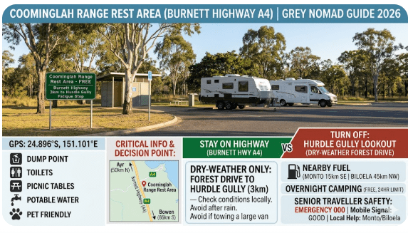
Coominglah Range Rest Area is one of those Queensland highway stops that matters more than it first appears. For grey nomads travelling the Burnett Highway between Monto and Biloela, it is a practical fatigue stop, a useful toilet break, and the decision point for whether you continue on the sealed highway or turn off toward the dry-weather forest drive to Hurdle Gully lookout.
This 2026 guide gives you the practical details most travellers actually need before they roll in with a car, SUV, 4WD, campervan, motorhome or caravan: how to get there, whether the road is sealed, what happens after rain, whether it floods, what services are nearby, where the nearest fuel is in each direction, whether camping is legal, and what safe overnight alternatives exist nearby.
Important camping rule: Public information for Coominglah State Forest states that camping is not permitted in Coominglah State Forest. Treat Coominglah Range Rest Area as a roadside rest stop first, not a destination campground, unless on-site signage specifically states otherwise. For legal overnight stays, use a confirmed camp, park or caravan park nearby.
Why seniors like this stop: easy highway access, a toilet before the forest side-road, a quieter bush setting than many town stops, and a good jumping-off point for a scenic day drive in dry weather. The catch is that the forest roads beyond the rest area are a different proposition entirely. Unlike larger, fully serviced highway stops like Six Mile Creek Rest Area, Coominglah remains a basic roadside facility.
Table of Contents
- Why Grey Nomads Stop at Coominglah Range Rest Area
- Free Camping — Know the Limits for Seniors
- Your Two Main Options Side by Side
- Quick Facts and Key Details 2026
- How to Get to Coominglah Range Rest Area
- Road Conditions, Flooding and Unsealed Sections
- Heat, Wildlife and Remoteness — Senior Safety Notes
- Wildlife — Birds, Reptiles and What to Watch For
- What Other Google Websites Don’t Tell You Online
- Best Time to Visit — Month-by-Month Breakdown
- Free and Low-Cost Camping Nearby
- Dump Points Near Coominglah Range Rest Area
- Free Water Sources Near the Location
- Fuel Stops Along the Burnett Highway
- Is There a Caravan Park — Paid Alternatives
- Full Facilities Comparison Table
- Rates — All Options Near Coominglah Range Rest Area for 2026
- A Senior Day Planner for the Area
- Senior Checklist — Safety On and Off the Road
- What to Do Near Coominglah Range Rest Area
- GPS Coordinates and Postcodes — Save Every Stop
- Stargazing
- History of the Area
- Phone Signal and Emergency Communications
- Campfires, Cooking Restrictions and Food Purchases
- Pets at Coominglah Range Rest Area
- Accessibility for Seniors with Mobility Limitations
- Camping Etiquette and Waste Management
- Emergency Scenarios — What to Do
- Packing List for This Section of Highway
- Rest Area Comparisons — Nearby Options
- Permits and Park Fees
- Reviews — What Real Grey Nomads Tend to Say
- People Also Ask
- Frequently Asked Questions
- Quick-Reference Card
- 🗺️ Interactive Free Camp Finder Map
- Disclaimer
Why Grey Nomads Stop at Coominglah Range Rest Area
For most senior travellers, Coominglah Range Rest Area is not about flashy facilities. It is about timing, comfort and decision-making. If you are driving the Burnett Highway and want to break the run between towns, stretch the legs, use a toilet, and avoid pushing on while tired, this stop works well.
It is also strategically useful because it sits near the turnoff used for the Hurdle Gully lookout drive. That means it becomes the natural place to decide whether you are:
- simply taking a highway rest break and continuing on, or
- heading into the forest on a dry-weather, 4WD-recommended drive.
For grey nomads, that distinction matters. The rest area itself is a straightforward highway stop. The roads beyond it are not.
Free Camping — Know the Limits for Seniors
One of the biggest mistakes travellers make online is to blur the line between a rest area, a free camp, and a legal overnight stop. They are not always the same thing.
With Coominglah Range Rest Area, the safest planning approach for 2026 is this:
- Use it as a rest area first.
- Do not assume destination camping is permitted.
- Camping is not permitted in Coominglah State Forest.
- Always obey the signs on arrival, because local rules and fatigue-stop conditions can change.
Senior travel advice: if you need a guaranteed legal overnight stop with a caravan, motorhome or campervan, plan for a proper campground, forest camp where camping is officially allowed, or a caravan park in Monto, Cania or Biloela. Do not rely on a remote forest-side stop if you arrive late, tired or in wet weather.
Your Two Main Options Side by Side
| Option | Best For | Road Type | Vehicle Suitability | Overnight? |
|---|---|---|---|---|
| Coominglah Range Rest Area only | Short rest break, toilet stop, driver fatigue management, quick picnic | Sealed Burnett Highway access into rest turnout | Cars, SUVs, 2WDs, motorhomes, campervans, caravans using normal highway caution | Check signage on arrival; do not treat it as a campground by default |
| Rest area + Hurdle Gully / Coominglah forest drive | Scenic outing, birdwatching, lookout visit, day drive | Forest roads with unsealed, steep and slippery sections in wet weather | Dry-weather 4WD recommended; some sections suit only high-clearance vehicles and more capable 4WDs | No camping in Coominglah State Forest |
Quick Facts and Key Details 2026
| Detail | What You Need to Know |
|---|---|
| Location | On or just off the Burnett Highway near the Kington Road / Hurdle Gully lookout turnoff, roughly 19km from Monto toward Biloela |
| Main use | Roadside rest stop and last toilet before the forest drive to Hurdle Gully lookout |
| Camping | Camping is not permitted in Coominglah State Forest. Rest area overnight use should be checked against local signage |
| Toilet | Yes, at the rest area; this is the last toilet on the drive toward the lookout |
| Water | No confirmed potable water to rely on at the rest area or lookout |
| Lookout facilities | Picnic tables and parking only; no water and no toilet |
| Road beyond rest area | Forest roads can be steep, winding, unsealed and dangerously slippery after even light rain |
| Best vehicle for forest drive | 4WD, preferably high-clearance, in dry conditions only |
| Phone signal | Very limited in the forest area and non-existent in places |
| Fuel anchors | Top up in Monto or Biloela; do not expect fuel in the forest |
How to Get to Coominglah Range Rest Area
From Monto
From Monto, travel on the Burnett Highway toward Biloela. Public park information states the signposted rest area / Hurdle Gully lookout turnoff is about 19km from Monto. This is the simplest approach for most travellers.
From Biloela
From Biloela, head south/south-east on the Burnett Highway toward Monto. The rest area is the most practical bush-side stop before reaching Monto. Depending on your exact start point in Biloela, plan on roughly 75–80km to the rest area.
From Cania Gorge or Lake Cania
If you are coming from Cania Gorge National Park or Lake Cania, the normal, easy route for most vehicles is back through Cania Road, then toward Monto, then out again on the Burnett Highway. The cross-forest route is not the route to take with a caravan or standard 2WD campervan.
Suitability by vehicle type
| Vehicle Type | To the Rest Area | Beyond the Rest Area into Coominglah State Forest | Practical Advice |
|---|---|---|---|
| 2WD car / sedan | Yes | Not recommended once roads are wet; use caution even in dry weather | Best used for highway stop only unless conditions are clearly dry and route advice is current |
| AWD SUV | Yes | Dry-weather only; still not a substitute for a proper 4WD on rough sections | Do not overestimate traction on clay roads |
| High-clearance 4WD | Yes | Best option for the forest drive; dry conditions still essential | Carry recovery gear, water and offline maps |
| Motorhome / campervan | Yes, as a rest stop | No, not suitable for forest drive | Stop, use the toilet, then continue to a legal overnight base |
| Car + caravan / on-road camper trailer | Yes, for the rest area turnout | No, forest roads are not suitable | Leave the van in town or skip the forest side trip |
| Trail bike / bicycle / horse | Highway caution required | Permitted on some State Forest roads | Check current local access and ride/road conditions first |
Road Conditions, Flooding and Unsealed Sections
This is the section most travellers need to get right.
The Burnett Highway access to Coominglah Range Rest Area is the easy part. It is the internal forest roads that change the risk level. Public information for Coominglah State Forest explains that the soils in the area are weathered sandstones and clays, and those surfaces can become extremely slippery in wet weather.
Critical warning: do not attempt the steeper sections of the forest roads in wet weather. Even after a light shower, traction can disappear, braking can become difficult, and vehicles can slide into soft shoulders or boggy patches. If you get stuck, help can be hours away.
Does the road flood?
The better question here is not “Does it flood like a river crossing?” but “How badly does rain affect drivability?” The answer is: rain matters a lot.
- Burnett Highway: generally the reliable all-weather route, subject to broader regional closures or storm events.
- Rest area turnout: usually manageable as a normal roadside stop.
- Kington Road / forest routes: weather-sensitive, slippery, and not to be treated as all-weather touring roads.
- Loop roads such as Davies, Scrubby and Hurdle Gully Road: steep and hazardous in wet conditions.
So while this is not primarily known as a flood-causeway stop, the area is absolutely one where wet weather can make the unsealed roads unsafe very quickly.
Is the road unsealed?
Yes, once you leave the highway and head deeper into the forest drive, expect unsealed sections. The rest area is accessed from the sealed highway, but the scenic drive beyond involves forest roads rather than sealed touring roads.
Road summary by route
| Route | Surface / Condition | Safe for Caravans? | Wet Weather Risk |
|---|---|---|---|
| Burnett Highway to Coominglah Range Rest Area | Sealed highway access | Generally yes for normal highway travellers | Low to moderate depending on wider weather events |
| Rest Area to Hurdle Gully lookout via Kington Road | Forest road, dry-weather scenic drive | No | High — slippery after rain |
| Lookout loop via Davies / Scrubby / Hurdle Gully Road back to Monto | Steep, winding, variable maintenance | No | Very high — 4WD only in dry conditions |
| Lookout through to Cania Gorge area | Mixed local and forest roads | No for most vans and 2WD rigs | High — verify route condition before committing |
Good senior strategy: if you are towing, use Coominglah Range Rest Area as a leg-stretch stop only. If you want to see the forest drive, do it as a separate day trip in a suitable vehicle from a proper base in Monto, Cania or Biloela.
Heat, Wildlife and Remoteness — Senior Safety Notes
Even experienced outback and bush travellers can underestimate this area because it sits so close to a highway. The remoteness begins as soon as you leave sealed, serviced town travel behind.
- There is very limited mobile reception in the forest area.
- There is no water or toilet at the lookout.
- There are no shops or fuel in the forest.
- Hot weather can be draining, especially if you are walking around in the middle of the day.
- If you leave the highway and have a mishap, assistance may not be quick.
If you are a senior traveller with reduced mobility, balance issues, heat sensitivity or medication that increases dehydration risk, keep the stop short and well planned.
Wildlife — Birds, Reptiles and What to Watch For
Coominglah State Forest supports a surprisingly rich bush environment, with publicly reported figures of about 650 plant species and 440 animal species. That makes it a rewarding place for wildlife watchers, especially if you enjoy forest birds and quieter bush habitats.
Species and signs to look for
- Glossy black-cockatoos — look for chewed allocasuarina seed pods under trees.
- Yellow-bellied gliders — active at night, noisy and social.
- Golden-tailed gecko — small but notable forest reptile.
- Eastern grey kangaroos — commonly seen in grassy understorey or near clearings.
- Wedge-tailed eagles — often soaring high over the canopy.
- Microbats and butterflies — especially if you slow down and actually watch the bush rather than just drive through it.
Also keep the usual Queensland bush sense about you: snakes can be present in warmer months, insects can be annoying after rain, and kangaroos become a real hazard near dawn and dusk.
What Other Google Websites Don’t Tell You Online
Here are the practical details that tend to get missed in shorter travel blurbs:
- The rest area toilet matters. It is the last toilet before the lookout drive.
- The lookout has no toilet and no water. Many people assume a lookout means basic facilities. Not here.
- Camping is not permitted in Coominglah State Forest. This catches people out.
- The issue is not only heavy rain. Even a light shower can make parts of the road treacherous.
- The forest roads are not caravan roads. Public advice specifically says the forest roads are not suitable for caravans, 2WD campervans, mobile homes or conventional on-road camper trailers.
- Some 4WD roads need more than just AWD confidence. Certain sections can require high clearance and locking capability depending on conditions.
- Mobile reception is unreliable. Do not assume you can simply ring for help if you get bogged.
- Gates have rules. Leave gates as you find them—open stays open, closed gets closed behind you, locked means no access.
Best Time to Visit — Month-by-Month Breakdown
| Month | What It’s Like | Senior Traveller Verdict |
|---|---|---|
| January | Hot, stormy, humid; traction problems likely on forest roads | Highway stop only unless conditions are unusually dry |
| February | Summer rain risk remains high | Generally poor month for forest side trips |
| March | Conditions begin improving, but late wet-season rain can linger | Check roads carefully before turning off |
| April | Often a nicer shoulder month with greener scenery | Good if dry; excellent time for birding |
| May | Cooler and more stable | One of the best months for seniors |
| June | Dry, comfortable daytime travel | Excellent |
| July | Cool mornings, usually pleasant days | Excellent |
| August | Generally dry and easy for touring | Excellent |
| September | Warmer, still usually good touring weather | Very good |
| October | Heat begins building; dust and dryness possible | Good for early starts |
| November | Storm build-up begins | Be cautious with forest detours |
| December | Hot and storm-prone | Best kept as a short roadside stop |
Free and Low-Cost Camping Nearby
Because camping is not permitted in Coominglah State Forest, the smart move is to use legal alternatives nearby. The table below mixes rest stops, official camping areas mentioned in public park information, and practical paid bases for seniors who want showers, power or an easier overnight.
Coordinates note: the coordinates below are publicly available planning coordinates taken from commonly used public map pins and park locality references. They are intended to help you find the area, not to replace current signage or the operator’s own check-in directions. In remote areas, always verify before departure.
| Name | Address | Postcode | Latitude / Longitude | Coordinate Source | Notes | Nearby Public Wi-Fi |
|---|---|---|---|---|---|---|
| Coominglah Range Rest Area | Burnett Highway near Kington Road / Hurdle Gully lookout turnoff, near Monto QLD | 4630 | -24.734, 150.984 | Public map pin / road mapping | Use as a fatigue stop first. Toilet on site. No confirmed potable water. Check signs before any overnight rest. | None on site. Nearest practical town Wi-Fi options are in Monto or Biloela. |
| Kalpowar State Forest camping area | Kalpowar area, north of Monto QLD | 4630 | -24.648, 150.940 | Public park locality map / public map reference | Public information states camping is available in Kalpowar State Forest. Remote and basic. Confirm exact campground, access conditions and any permit needs before travel. | No on-site public Wi-Fi. Use Monto or Biloela before heading in. |
| Tolderodden Conservation Park camping area | West of Eidsvold QLD | 4627 | -25.414, 151.017 | Public park locality map / public map reference | Public information states camping is available. Remote bush option. Check booking, access and fire conditions before going. | Nearest practical public Wi-Fi is usually in Eidsvold township. |
| Cania area caravan/camping base | Cania Road, Cania QLD | 4630 | -24.620, 150.990 | Public business map listing | Paid option near Cania Gorge and Lake Cania. Best comfort base if you want showers, powered sites and a slower pace. | Guest Wi-Fi may be available through operators; public options are more reliable back in Monto. |
| Monto town stay / caravan park base | Monto QLD | 4630 | -24.865, 151.122 | Public town-centre coordinates | Best southern base with fuel, groceries, pharmacy and town services. Good option if weather makes the forest roads unwise. | Town-centre civic areas, library precincts and some cafes may offer public or guest Wi-Fi; confirm current availability. |
| Biloela town stay / caravan park base | Biloela QLD | 4715 | -24.396, 150.517 | Public town-centre coordinates | Best northern service base with broader shopping and fuel options. | Town-centre civic areas, library precincts and some cafes may offer public or guest Wi-Fi; confirm current availability. |
🗺️ Interactive Free Camp Finder Map
If you want to cross-check legal overnight options, free camps and rest areas around Coominglah Range Rest Area, Monto, Cania and Biloela, use the interactive map below.
COPY PROMPT ➔ ASK AI ➔ SAVE TO FORM ➔ ADD SPOT PIN ➔ GET DIRECTIONS
📍 Interactive map — find free camps, rest areas and overnight stops. Enable location for best results.
Dump Points Near Coominglah Range Rest Area
There is no dump point at Coominglah Range Rest Area and none at Hurdle Gully lookout. For caravanners and motorhome travellers, the practical dump-and-refill strategy is simple:
- Southbound / based in Monto: dump and refill in town before driving out.
- Northbound / based in Biloela: sort waste and water in Biloela before heading south.
- Staying in a caravan park: use park facilities rather than trying to wing it from the roadside.
Because dump point listings can change, verify current locations in your preferred dump point app, council listings or caravan park information before arrival.
Free Water Sources Near the Location
Do not rely on finding drinking water at Coominglah Range Rest Area or along the lookout drive.
- No confirmed potable water should be assumed at the rest area.
- The lookout has no water.
- There is no reason to expect treated water on the forest roads.
- Lake Cania is not a substitute for potable drinking water.
Your safest plan is to fill in Monto or Biloela, then carry enough water for the day plus an emergency reserve.
Fuel Stops Along the Burnett Highway
Fuel planning around Coominglah Range Rest Area is easy if you stay on the highway and much riskier if you assume a bush detour will have services. It will not.
| Direction from Coominglah Range Rest Area | Nearest Reliable Fuel Stop | Approximate Distance | Notes for Grey Nomads |
|---|---|---|---|
| South / South-East | Monto | About 19km | Your closest confirmed town fuel option. Best place to top up before any forest side trip. |
| North / North-West | Biloela | About 75–80km | Main northbound fuel and grocery anchor. Good backup if Monto was missed. |
| East | No dependable bush fuel—treat Monto as your fuel base | N/A | If you are heading toward Cania or scenic back roads, do not assume fuel availability en route. |
| West | No fuel in Coominglah forest roads | N/A | There is no practical “west of the rest area” fuel plan through the forest. Use town fuel before detouring. |
Simple rule: if your fuel gauge is below comfort level when you reach Monto or Biloela, fill there. Coominglah Range Rest Area is not where you want to start wondering how far the next bowser is.
Is There a Caravan Park — Paid Alternatives
Yes. If you want a comfortable base instead of testing a remote rest area or weather-sensitive forest road, the easiest paid alternatives are:
- Monto — best southern service town with shops, fuel and support services.
- Cania / Lake Cania area — best scenic base if you want to visit the gorge and lake.
- Biloela — best northern full-service town option.
For seniors wanting a hot shower, level site, power, easier waste disposal and less uncertainty, a caravan park base makes far more sense than treating Coominglah as an overnight destination.
Full Facilities Comparison Table
| Feature | Coominglah Range Rest Area | Hurdle Gully Lookout | Cania Gorge Day-Use Area | Monto / Biloela Town Base |
|---|---|---|---|---|
| Toilet | Yes | No | Yes | Yes |
| Drinking water | Not confirmed — do not rely on it | No | Carry your own unless separately confirmed | Yes in town services / accommodation settings |
| Picnic tables | Basic stop facilities | Yes | Yes | Yes, depending on site |
| BBQ | Not confirmed | No | Electric barbecue | Depends on park or public facility |
| Caravan-friendly access | Yes for stop-in use | No | Via normal touring roads, yes | Yes |
| Camping / overnight certainty | Check signage | No | Day use | Yes |
| Fuel nearby | No | No | No reliable fuel to assume | Yes |
| Mobile coverage | Variable | Very limited | Variable | Usually better than forest areas |
| Best use | Rest break | Short scenic stop | Lunch stop / walking base | Legal overnight base |
Rates — All Options Near Coominglah Range Rest Area for 2026
Because prices change, especially for caravan parks and bookable bush sites, the table below is best used as a planning guide, not a substitute for checking current operator pricing.
| Option | Indicative 2026 Cost | Comment |
|---|---|---|
| Coominglah Range Rest Area | $0 | Roadside rest stop, not a full campground |
| Hurdle Gully lookout | $0 day use | No camping and no facilities beyond tables / parking |
| Coominglah State Forest camping | Not applicable | Camping not permitted |
| Kalpowar State Forest / Tolderodden Conservation Park camping | Check current official fee / permit requirement | Do not rely on old blog prices |
| Monto / Cania / Biloela caravan parks | Usually budget to mid-range paid camping | Expect seasonal variation and powered/unpowered differences |
Create a Day Planner for Seniors in the Area
If you want to enjoy the area without overdoing it, this is a realistic senior-friendly day plan from Monto:
- 8:00am — Monto: fuel up, grab groceries, fill water, use town services.
- 8:30am — Depart Monto: head toward Biloela on the Burnett Highway.
- 9:00am — Coominglah Range Rest Area: toilet stop, tea, stretch, check weather and road confidence.
- 9:15am — Decision point: highway continue, or in a suitable 4WD and dry conditions, head toward Hurdle Gully lookout.
- 10:00am — Lookout: enjoy the view and short break. Keep snacks and water with you.
- 11:00am: either return to Monto the safe way, or continue only if your route, vehicle and weather all stack up.
- 12:30pm — Cania Gorge day-use area: lunch, toilets, picnic tables, electric barbecue, easy sightseeing.
- 2:30pm — Lake Cania or Cania village area: quiet scenic stop.
- 4:00pm: return to your legal overnight base before dusk to reduce wildlife strike risk.
Best senior version of this trip: stay in Monto or Cania, and do Coominglah / Hurdle Gully as a day drive in dry weather only. That way you are not making bush-road decisions while tired near sunset.
Senior Checklist — For Safety On and Off the Road
- Fuel in Monto or Biloela
- Carry extra drinking water, not just “enough for lunch”
- Use the rest area toilet before heading to the lookout
- Do not assume water or a toilet at Hurdle Gully lookout
- Check weather before entering forest roads
- Avoid the forest drive after even light rain
- Do not take caravans, 2WD campervans or on-road camper trailers into the forest roads
- Tell someone your route and expected return time
- Carry offline maps
- Take recovery gear if driving a 4WD route
- Keep snacks, medications, hat and first aid handy
- Try to be back at camp before dusk
What to Do Near Coominglah Range Rest Area — Senior Activity Guide
- Take a proper rest break — often the most sensible reason to stop.
- Drive to Hurdle Gully lookout in suitable dry conditions.
- Birdwatch — glossy black-cockatoos and wedge-tailed eagles are highlights.
- Visit Cania Gorge National Park day-use area for a more facility-supported outing.
- Continue to Lake Cania for boating, fishing views and a change of scenery.
- Return to Monto for town comforts, supplies and an easier overnight stop.
GPS Coordinates and Postcodes — Save Every Stop
These are practical public planning coordinates for commonly used map searches. Verify before travel.
| Stop | Postcode | Approximate Coordinates | Use |
|---|---|---|---|
| Coominglah Range Rest Area | 4630 | -24.734, 150.984 | Rest area / toilet stop / forest-drive turnoff |
| Monto | 4630 | -24.865, 151.122 | Fuel, groceries, town services, paid stays |
| Cania Gorge day-use vicinity | 4630 | -24.633, 150.988 | Picnic stop, toilets, walks |
| Lake Cania vicinity | 4630 | -24.596, 150.975 | Scenic lake stop, boating access |
| Biloela | 4715 | -24.396, 150.517 | Fuel, groceries, northern service town |
| Eidsvold | 4627 | -25.367, 151.129 | Reference town for Tolderodden area |
Stargazing at Coominglah Range Rest Area
The wider district can offer very dark skies, but there is an important difference between enjoying stars and making a poor overnight decision. If you want a proper stargazing evening, do it from a legal overnight base rather than assuming the rest area is the right place to camp.
Good options include a legal bush camp where permitted, or a caravan park base around Cania or Monto. Also remember that night driving in this region increases the chance of wildlife on the road.
History of the Location
Coominglah State Forest has a strong working-forest history. Many of the roads and tracks in the area were originally used to haul logs to local sawmills. Today, some of those tracks remain as fire control lines while others are scenic forest-drive routes. The area also protects important natural values, including the unusual Hurdle Gully Scrub, one of the last remaining patches of its dry rainforest type in Queensland and possibly beyond.
Phone Signal and Emergency Communications in the Area
Do not plan this area as if it were an urban roadside stop. Public advice says mobile reception is very limited across the State Forest and non-existent in places.
- Download offline maps before leaving Monto or Biloela.
- Tell a responsible person your route and return time.
- Carry a power bank and charging cable.
- If travelling solo in a 4WD, consider a satellite communicator or emergency beacon.
- On the highway, a UHF can still help with general road awareness, though not everyone uses it.
Road-trip gear worth carrying here: offline maps, a torch, tyre pressure gauge, recovery gear for 4WD travel, extra drinking water, power bank, and a simple paper note with emergency contact numbers. This is also a natural place to insert your own affiliate gear links in WordPress if you use them.
Campfires and Cooking Restrictions & Food Purchases In or Near the Area
There are no shops at the rest area or lookout. Buy food in Monto or Biloela. If you continue toward Cania, public information notes there is a kiosk at Lake Cania, but do not build your whole food plan around a remote kiosk.
For cooking:
- Do not assume campfires are allowed at any roadside stop.
- Observe local fire bans and total fire restrictions.
- A gas stove is the safest backup for self-contained travellers.
- At Cania Gorge day-use area, an electric barbecue is available.
Pets at Coominglah Range Rest Area
At a roadside rest area, pets are usually manageable if they are on a lead, controlled and cleaned up after. But never assume that pet rules at a rest area are the same as nearby protected areas. If you continue on to national park areas such as Cania Gorge National Park, pet restrictions are often much tighter or pets may be prohibited.
Accessibility for Seniors with Mobility Limitations
Coominglah Range Rest Area is more suitable for a short break than a long accessible stay. The advantages are simple: roadside access and a toilet. The limitations are equally simple: no broad range of services, uncertain signal, and no easy accessible tourism infrastructure once you head deeper into the forest.
For mobility-limited seniors, the better plan is often:
- short stop at the rest area, then
- longer break in Monto, Biloela or the Cania Gorge day-use area, where facilities are more predictable.
Camping Etiquette and Waste Management
- Do not overstay where only rest use is intended.
- Take all rubbish with you if bins are limited or full.
- Do not dump grey water or toilet waste.
- Keep noise low, especially early morning and late evening.
- Give trucks and larger vehicles room to manoeuvre.
- Leave gates exactly as you find them on forest roads.
- Stay on formed roads and do not create new tracks.
Emergency Scenarios — What to Do
If the road turns slippery after rain
Do not keep pressing on to “see how it goes.” Turn back early while you still have traction and options.
If you get stuck
Stay with the vehicle unless there is an immediate danger. Conserve water, try communications, and use recovery gear only if you know how to use it safely.
If someone has a medical issue
Use phone or satellite communication if available, then move only if safe. Heat, dehydration and falls can escalate quickly in remote areas.
If you lose signal
This is normal in parts of the forest. It is one reason you should have told someone your plan before leaving town.
Packing List for This Section of Highway
- Drinking water plus reserve water
- Hat, sunscreen and insect repellent
- Paper map or printed park map
- Offline maps on your phone or tablet
- Charged phone and power bank
- Snacks and medication
- Recovery gear if leaving the highway in a 4WD
- Tyre inflator and basic puncture support
- Torch or headlamp
- Small first aid kit
- Wet-weather caution and a willingness to turn back
Rest Area Comparisons — Other Nearby Options
| Stop | Best For | Weak Point | Best Traveller Type |
|---|---|---|---|
| Coominglah Range Rest Area | Highway break before or after the forest turnoff | Limited services, overnight uncertainty | Through-travellers, day trippers |
| Hurdle Gully Lookout | Short scenic stop | No toilet, no water | Dry-weather 4WD day visitors |
| Cania Gorge day-use area | Picnic, toilets, BBQ, walks | Not a fuel stop | Seniors wanting a more comfortable day outing |
| Monto town base | Fuel, services, secure overnight planning | Less bush feel | Caravanners, motorhomes, anyone wanting certainty |
| Biloela town base | Northern service centre | Further from Cania side trips | Northbound or southbound service reset |
Permits and Park Fees
- Coominglah Range Rest Area: no permit for a normal roadside stop.
- Coominglah State Forest: camping not permitted.
- Kalpowar State Forest / Tolderodden Conservation Park: check current official camping requirements, bookings and fees before travel.
- Cania Gorge day use: check current park information, but day-use access is typically straightforward.
Reviews — What Real Grey Nomads Tend to Say About the Location
Across public traveller comments and map-based stop reports, the same themes usually come up:
- It is a useful break point on the Burnett Highway.
- The bush setting is appreciated, especially by drivers wanting a quieter pause.
- People like having a toilet before the lookout drive.
- The biggest negatives are limited services, patchy signal and confusion over overnight rules.
- Travellers who ignore wet-weather advice often end up regretting it.
People Also Ask — Coominglah Range Rest Area
Can you camp at Coominglah Range Rest Area?
Do not assume so. Use it as a roadside rest stop and check signage on arrival. Camping is not permitted in Coominglah State Forest.
Is the road to Hurdle Gully lookout sealed?
No. The highway access to the rest area is straightforward, but the forest roads beyond are weather-sensitive and not regular sealed touring roads.
Can caravans go into Coominglah State Forest?
Public guidance says the forest roads are not suitable for caravans, 2WD campervans, mobile homes or conventional on-road camper trailers.
How far is Coominglah Range Rest Area from Monto?
About 19km, according to public park driving information.
Is there phone signal at Coominglah Range Rest Area?
Signal may be variable near the highway, but the forest area has very limited reception and dead spots.
Frequently Asked Questions
Is Coominglah Range Rest Area worth stopping at?
Yes, especially as a fatigue stop, toilet break and decision point before the forest drive. It is more useful than scenic.
What is the biggest mistake first-time visitors make?
Assuming the forest road is just another easy scenic detour. It is not, especially after rain or when towing.
Is there drinking water at the lookout?
No. Carry your own water.
What is the safest senior travel plan?
Base yourself in Monto, Cania or Biloela, then do Coominglah and Hurdle Gully as a day outing in dry weather.
Can you rely on finding food there?
No. Buy supplies in town before you go.
What if the weather looks uncertain?
Use the rest area for a short stop only and stay on the highway. That is the conservative and usually correct choice.
Quick-Reference Card
Coominglah Range Rest Area — 2026 Quick Card
- Best use: highway rest break and toilet stop
- From Monto: about 19km toward Biloela
- From Biloela: about 75–80km toward Monto
- Road surface: sealed highway access; forest roads beyond are unsealed / variable
- Wet weather: avoid forest roads after rain
- Camping: do not assume; check signs. Camping not permitted in Coominglah State Forest
- Toilet: yes at rest area
- Water: carry your own
- Fuel south: Monto
- Fuel north: Biloela
- Signal: limited in forest
- Best base towns: Monto, Cania, Biloela
Final Verdict
Coominglah Range Rest Area is a good practical stop for grey nomads, but only if you understand what it is and what it is not. It is not a feature-packed campground. It is a useful roadside break on the Burnett Highway and the gateway to a scenic bush drive that should only be attempted in the right vehicle and the right conditions.
If you are travelling in a car, campervan, motorhome or caravan, the simplest advice is this: stop, rest, use the toilet, assess the weather, and keep your overnight plan in a legal town or park base. If you are in a capable 4WD and the roads are dry, the lookout drive can be a rewarding extra.
Disclaimer
This guide is written for travel planning and SEO publishing purposes using publicly available information current to April 2026, including Queensland Parks driving and visitor information and public mapping references. Conditions, signage, camping permissions, access, prices, road closures, facilities and Wi-Fi availability can change without notice. Always obey on-site signs and check current official road and park information before travel. Coordinates listed are planning coordinates only and should be verified in your own navigation system.
Source note: Key official facts used in this guide include that camping is not permitted in Coominglah State Forest, the Hurdle Gully lookout drive is dry-weather 4WD recommended, the rest area is the last toilet before the drive, the lookout has no water or toilet, and mobile reception can be very limited or absent in places.
📍 HELPFUL QUEENSLAND TRAVEL RESOURCES
✅ Monto Travel Guide: Explore the “Magic of Monto” including the famous silo art and dairy cow statues. 🔗 https://www.northburnett.qld.gov.au/montos-magic/
✅ Biloela Travel Guide: Your hub for the Callide Valley, featuring the Queensland Heritage Park and Spirit of the Land Mural. 🔗 https://sandstonewonders.com/places/biloela/
✅ Cania Gorge Guide: Complete guide to the 8 walking tracks, ancient caves, and the spectacular Cania Dam. 🔗 https://caravanworld.com.au/blogs/qld-caravan-and-touring-locations/travel-guide-for-cania-gorge-national-park-qld
✅ Queensland Free Camps Hub: A comprehensive list of the best freedom camping spots across the state. 🔗
✅ https://www.queensland.com/au/en/plan-your-holiday/accommodation/camping-and-caravan-parks/queenslands-best-free-campsites
Free campsites and powered sites fill fast during school holidays and peak season. If your preferred site is already gone, search remaining accommodation options below to explore the region.
Accommodation and flight search powered by Expedia. Booking through this search supports this website at no extra cost to you. As an affiliate, I earn from qualifying purchases at no extra cost to you.

As an affiliate, I earn from qualifying purchases at no extra cost to you.
Exclusive Offer: Get 5% OFF all StarterStopper immobiliser products with promo code: RTV5
Visit StarterStopper.com to see our data-backed security solutions
As an affiliate, I earn from qualifying purchases at no extra cost to you.